 Mike's Weather Page
@tropicalupdate

Well? I'm getting old.


Politicians, athletes, journalists, NGOs, companies... They all use corporation-owned social networks to communicate with us. Citizens shouldn't have to hand over their data to companies to read content published by public entities. Public Feeds changes that by making posts of popular accounts freely available. Read more.
Michael Jerome Boylan (born October 17, 1973) is an American video blogger and storm chaser from Oldsmar, Florida. More on Wikipedia
MWP was born in 2004. Posting about Tropics, Weather, & more. The Daily Brew 9:19am EST weekdays. https://t.co/R2Zlj1oLtb. mikesweatherpage@gmail.com
Mike's Weather Page
@tropicalupdate
Well? I'm getting old.
Mike's Weather Page
@tropicalupdate
El Nino tends to get interesting during fall and winter for the Florida peninsula. History usually repeats itself. Past El Nino years here with some significant weather. Flooding. Tornados. Snow. Already seeing the flooding. Might be a busy few months ahead.
 Mike's Weather Page
@tropicalupdate
Yucky... Chilly... Drizzle. Gulf juice has made it east. Watching east coast Florida big totals rest of week as blob hangs around. www.spaghettimodels.com
 Mike's Weather Page
@tropicalupdate
Monday 11/16/26 Weather Update: Big rains on the way for Florida again. East coast specifically. Here's my thoughts and the latest.
Mike's Weather Page
@tropicalupdate
Latest WPC excessive rainfall outlooks. Level 2/4 through the week. Not comparing numbers to a couple weeks ago but it had the same level 2/4 predicted. East side of the state the ones to watch. GFS/EURO showing some isolated big numbers. Just in completely different areas. That is why it is so hard to predict who gets what, where and when. www.spaghettimodels.com
 Mike's Weather Page
@tropicalupdate
Awesome interview Emmy. Proud of you girl. Cleetus with some great conversation and answers to your questions.
 Emily Boylan
@SportsWithEmmy
Had an awesome time getting the opportunity to interview Cleetus McFarland at New Smyrna Speedway! Huge thank you to him! Hope you guys enjoy.🎤🏁
Mike's Weather Page
@tropicalupdate
Monday's 11/16/26 "Daily Brew": x.com/i/broadcasts/2MEePlEJPenram
Mike's Weather Page
@tropicalupdate
Deja Vu? Middle US energy now sliding east through the Gulf. Current look here. Fueled by El Nino jet stream. Expected to park through the week and models showing big Florida east coast rains. Way too early to know who, or how much. But a couple weeks ago event looked similar. Models then only showed 4/5 inches from what I recall. Isolated downpours are what is hard to predict, as we saw. Keeping an eye on the things and chances. Timing starts tomorrow with the Florida east coast showing T/W/T/F level 2/4 flooding chances from the NOAA WPC (Weather Prediction Center). Same as a couple weeks ago. Not predicting a repeat. Just showing the setup. www.spaghettimodels.com
 Mike's Weather Page
@tropicalupdate
Emmy doing an interview with Cleetus McFarland. Can't wait to see it! @SportsWithEmmy
 Mike's Weather Page
@tropicalupdate
Just saw it. WOW. Can't wait to share it this AM when she posts.
Mike's Weather Page
@tropicalupdate
More east coast Florida rains on radar this week. Totals inching up there on models. Here is the basic setup which is similar to a couple weeks ago. Precipitable water map shows moisture in the air. Red/Yellow is available juice. Gulf area now sliding east. Parks. This upper low spins things up. Atlantic also high spins things up. Timing looks to start tomorrow with increased chances. Lasts until Saturday at least. Flooding chances show level 2/4 for east coast T/W/T/F (for now). www.spaghettimodels.com
Mike's Weather Page
@tropicalupdate
Storm Chaser is on display at the racetrack. Come check it out. New Smyrna Speedway today for the Bill Posey Florida Governors Cup!
 Mike's Weather Page
@tropicalupdate
Julie got me my Isaias sticker made for the trip.
Mike's Weather Page
@tropicalupdate
Florida east coast rains the story to watch this week. Gulf juice sliding east. Spins in some Atlantic influence. Similar setup as a couple weeks ago. Latest NOAA blend of models shows basic idea and coverage. Isolated amounts always can be higher, sometimes much higher. El Nino fueling. www.spaghettimodels.com
 Mike's Weather Page
@tropicalupdate
Family and I really had a great day at New Smyrna Speedway today. Appreciate the invite to be part of it and all the hospitality. Man those Late Models were loud and fast. Lots of history on that oval that's for sure!
Mike's Weather Page
@tropicalupdate
Next round of flooding rains for Florida this week ahead? GFS and EURO teasing some east coast heavy totals before the weekend. Similar setup as a couple weeks ago. Current Western Gulf juice mingles with Atlantic flow. We will sea. Latest Sunday 12z models here.

 Mike's Weather Page
@tropicalupdate
Sunday's big weather goes to Texas. Heavy rains continue with flooding in spots likely. Last week this looked to trek towards Florida but those chances fizzled. Today's maps here showing expected rains. www.spaghettimodels.com
 Mike's Weather Page
@tropicalupdate
The St. John's River near Cocoa, Florida is still in Major Flood stage from the heavy rains a couple weeks ago. Impacting several roads and homes currently. River flows slow and north. Yes north. Wild! www.spaghettimodels.com
 Mike's Weather Page
@tropicalupdate
Storm Chaser is excited this morning. It has passengers! Heading to New Smyrna Speedway today to be part of the Governor's Cup race. Come say hi! And push some buttons lol.
 Mike's Weather Page
@tropicalupdate
Florida is freezing. Literally. What is up with that. Current north state temps here showing widespread lower 30s. Couple spots in the 20s! Frost advisories in light blue. That is Florida's version of snow.
 Mike's Weather Page
@tropicalupdate
Home sweet home!
Mike's Weather Page
@tropicalupdate
It snowed inside my rental. That's how this Florida native chases snow. With the heat blasting and seat warmers on haha.
Mike's Weather Page
@tropicalupdate
Another chilly Saturday night on tap for the south and east. Frost advisories posted deeper down into the Florida and the Atlantic coast. With freeze warnings now touching the sunshine state. Couple spots hit 32 this AM including Milton. www.spaghettimodels.com
 Mike's Weather Page
@tropicalupdate
Made it home. I love window seats. I just stare. Today I searched for snow on mountains. Saw the puffiest white clouds. Parrelleled the Atlantic. So close to seeing both sides of the state. Couldn't believe how many horse tracks there are inland. And lakes. Saw a bunch of painted parking spaces at high schools. Instantly brought back memories of Emily. Was amazed at the flow of Gulf sand. And recognized all the spots we have been on our boat. Again some great memories. As we turned by the Ray's stadium the always sticking out like sore thumb blue tarps on roofs. Not like some years but still some sprinkled here and there. Not having Internet is good. Forces me to look around. Not as cold as the mountains but still a little chilly. Firepit is in the future for sure.


 Mike's Weather Page
@tropicalupdate
My man wheeling it!
 Carson Hocevar
@CarsonHocevar
Mike's Weather Page
@tropicalupdate
Until next time. Great little snow chase for sure. Thanks for coming along. Allegiant says I'm good to go. Fingers crossed.
 Mike's Weather Page
@tropicalupdate
Winter has invaded the south this Saturday AM. Widespread freeze. Frost advisories into Florida. That's our version of snow. Another round tomorrow AM before things start warming up. www.spaghettimodels.com
 Mike's Weather Page
@tropicalupdate
Big rains lower Texas this weekend. Few days ago looked like that would reach Florida early week. Not anymore. Makes it halfway then fizzles the journey. Rainfall expected shows here. www.spaghettimodels.com
 Mike's Weather Page
@tropicalupdate
Brrrrr. Saturday 6am current temps here. The big Florida cold front arrives. Now the yearly debate. Do you turn your heat on or keep it off?
 Mike's Weather Page
@tropicalupdate
The best part of the chase... is this... the end! Playing my jam. Cheers weather world.
Mike's Weather Page
@tropicalupdate
Heading back to Florida tomorrow. Excited to be part of this race on Sunday. Hope to see you there. Come say hi! Hope I'm thawed out by then.
 Mike's Weather Page
@tropicalupdate
Gatlinburg Snow incoming tonight? Patch of moisture near Knoxville heading that way. Temps are cooing off. Maybe just in time for late night flurries. Keep your eye to the sky later. Might just happen after all!
 Mike's Weather Page
@tropicalupdate
Recap from today's Snow Chase in the Smokies. Big success! Had such a great trip and made some new memories. Thanks for coming along as always.
Mike's Weather Page
@tropicalupdate
Well looks like I'm driving the rental back to Tampa. Many others aren't so lucky. What a mess.
 Mike's Weather Page
@tropicalupdate
Snow Chaser victory! Found our snow. Lots of it!
Mike's Weather Page
@tropicalupdate
Found snow!


 Mike's Weather Page
@tropicalupdate
Found snow!


 Mike's Weather Page
@tropicalupdate
Breathtaking up here!
 Mike's Weather Page
@tropicalupdate
Chasing snow. Found something just as cool. Fall color. Look at this! Top of the Smokies this AM. I will be in snow later but for now enjoying this
Mike's Weather Page
@tropicalupdate
Waking up to snow across the mountains this AM. Morning look at the Smokies. Living up to it's name for sure. Florida boy fixing to go find some. Wish me luck.
 Mike's Weather Page
@tropicalupdate
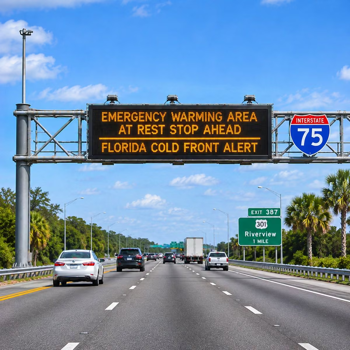
Florida not messing around. First big cold front of the year. 30s for north state tomorrow and Sunday.
 Mike's Weather Page
@tropicalupdate
Morning look at water vapor satellite. Can you see the front? Working south. Cool cold Canadian air rushing in behind. Are you ready? www.spaghettimodels.com
 Mike's Weather Page
@tropicalupdate
Great night. Not Florida this time. Snow tomorrow. Or I give up forecasting weather. Can't wait to see.


 Mike's Weather Page
@tropicalupdate
Woohooooo awesome can't wait. This Sunday Florida.
 Mike's Weather Page
@tropicalupdate
 Mike's Weather Page
@tropicalupdate
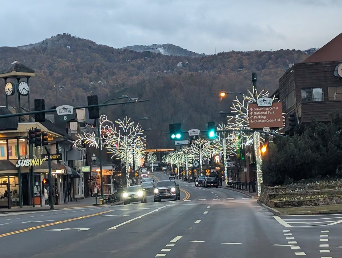
Made it. This familiar welcoming sign never disappoints. I hear there's chili happening downtown. Hmmmm. Hitting the higher mountains tomorrow for an adventure then chasing snow here into the evening hours. Hoping to catch a little action for sure. I come every year searching. An odd addiction yes. But one that has become a part of me. The changing leaves. The mountains. The cold air. All of it. And to make it even cooler the City of Gatlinburg just messaged me saying hi. Small world yes! Cheers.
 Mike's Weather Page
@tropicalupdate
Snow for the Smokies is relying a lot on the Great Lakes. Crazy yes. Counter-clockwise flow around current NE low will be helping bring the juice needed. Winds from the NW and a little help from the mountains upslope will make it happen. I'll be in it tomorrow later morning.
 Mike's Weather Page
@tropicalupdate
Not in Florida anymore lol...
 Mike's Weather Page
@tropicalupdate
Who wants to cruise with all your friends and family from MWP! An incredible good time with even more incredible great prices. Join our 6th annual Mike's Weather Page cruise out of Tampa on the @Margaritaville at Sea March 13th. Details below. Contact Kim before the rates go up. See ya for a great week and a ton of fun!
Special private cocktail party!
Meet n Greet!
Hurricane presentation!
Slot pull!
Group activities!
Free swag!
More!
 Mike's Weather Page
@tropicalupdate
New ENSO outlook released. Strong El Nino expected through winter. Leveling off expected entering Hurricane Season. What does that mean? Well some neutral years are active. And some are inactive. Flip a coin. www.spaghettimodels.com
 Mike's Weather Page
@tropicalupdate
Thank you so much MWP for helping raise money for Laura Dean and her family after losing so much during Hurricane Isaias. Trying to get even more so if you can help that would be awesome. Our annual 'Neighbors Helping Neighbors' benefit party this year will be giving back to her and her family. Hope you can join us for this event Saturday December 5th at Camp Margaritaville Auburndale. Full event details soon but party officially kicks off at 5pm. I will be doing a full stage presentation. FREE Happy Hour. Raffles. Band 7-10pm. Fun night for sure and for a good cause. You can camp or rent a cabin. Some fun earlier in the day too. Discounted rates with Margaritaville giving back to our benefit too! Details below. And the story with Laura and the Hurricane.
GoFundMe: www.gofundme.com/f/helping-a-family-impacted-from-hurrica…
Reservations: www.margaritavilleresorts.com/camp-margaritaville-rv-reso…
Mike's Weather Page
@tropicalupdate
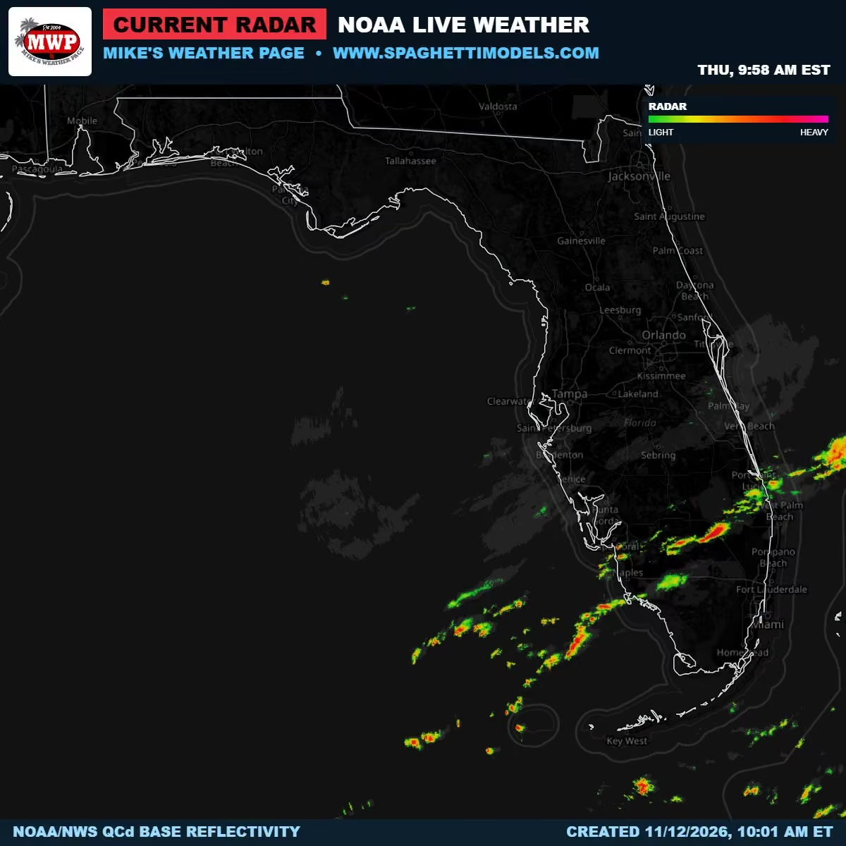
Current radar. Skinny line moving through south Florida right now. Frontal line comes through overnight with some more sprinkles attached. Cold air starts to then arrive. And some winds of course with it. www.spaghettimodels.com
 Mike's Weather Page
@tropicalupdate
Thursday's 11/12/26 "Daily Brew": x.com/i/broadcasts/2BlPoXWbKBEdbv
Mike's Weather Page
@tropicalupdate
Updated weekend weather. Frost and Freeze dipping south. Almost to the Florida Georgia line. And heavy rains remain for Texas and now Louisiana. It was looking like a future path eastward towards Florida. Overnight models trending more south now lowering chances for early next week action. www.spaghettimodels.com
 Mike's Weather Page
@tropicalupdate
Who left the door open? Cold Canadian air arrives this weekend for Florida. Temps running about 10 degrees colder than normal. Saturday and Sunday AM temps showing 30s north with 50s all the way south. The Keys stay a little more warm thanks to the water s surrounding. Someone warn the iguanas please. www.spaghettimodels.com
 Mike's Weather Page
@tropicalupdate
Checking Smoky Mountain snow forecast for this week. Always get nervous after I get the ticket to fly north. Latest overnight runs here. Nothing showing zero chances so that is good! Can't turn your back on the models. Forecasts are all over the place that is for sure. Excited to get there. Might meet a few of you there too it looks like. Who is excited about the chances? Timing looks like Friday the best day into Saturday AM. www.spaghettimodels.com
 Mike's Weather Page
@tropicalupdate
Texas weekend rains still on tap. That push towards Florida looking less on overnight models. Some dipping south of state now. Timing if that blob comes to Florida would be early week. Rainfall totals here the next 7 days. Not showing much for the sunshine state. We will sea.
 Mike's Weather Page
@tropicalupdate
Guess who's back? Old Man Winter! Cold air is making a deep south return this weekend. 30's make it into Florida Saturday and Sunday mornings. Current satellite here shows the first frontal line already in Florida tonight. www.spaghettimodels.com
 Mike's Weather Page
@tropicalupdate
Talking El Nino. What it has done. What it might do heading into winter. Was part of a panel and talked on the southeast specifically. Great information for the whole US. Thanks @foxweather for inviting me for this!
Mike's Weather Page
@tropicalupdate
Give my girl a follow as she begins her sports marketing journey!
Emily Boylan
@SportsWithEmmy
Hi guys!! Welcome to my official account where I will be covering all sports news and my opinions on everything. I’m very excited to be starting this and can’t wait to see where it goes! ❤️
Mike's Weather Page reposted
Emily Boylan
@SportsWithEmmy
Hi guys!! Welcome to my official account where I will be covering all sports news and my opinions on everything. I’m very excited to be starting this and can’t wait to see where it goes! ❤️
Mike's Weather Page
@tropicalupdate
Chasing Smoky Mountain snow chances. Minor impact possibilities here shows general idea of the best spots to get bigger stuff. Timing Friday mainly into early Saturday morning. Heading north tomorrow. Wish me luck! Will be live from Gatlinburg underneath their Christmas lights, with some snowflakes coming down! www.spaghettimodels.com
 Mike's Weather Page
@tropicalupdate
South Florida weather getting juicy this Wednesday afternoon and evening. SPC chances now level 1/5 for thunderstorms. And WPC with a level 1/4 for excessive rainfall. Storms expected to build and flow in from the west. www.spaghettimodels.com
 Mike's Weather Page
@tropicalupdate
Absolute crazy scene out of my local Walmart in Oldsmar, Florida. Carbon monoxide levels were unsafe this AM and the store had to be evacuated. And Florida being Florida they are using airboats to ventilate the store.
Mike's Weather Page
@tropicalupdate
Wednesday's 11/11/26 "Daily Brew": x.com/i/broadcasts/2POrMbrMPBOvoM
Mike's Weather Page
@tropicalupdate
A look at future radar today across the south. South Florida might get some isolated Thunderstorms as things roll in from the west. Big cold front coming helping push up the temps. And warmer moist air today. www.spaghettimodels.com
Mike's Weather Page
@tropicalupdate
11/11 Walking and talking...
Mike's Weather Page
@tropicalupdate
It's officially a 'socks and flops' weekend Florida. At least in the mornings haha. Widespread 30s expected up north with 50s making it way south. Saturday wakeup temps here. Sunday same. Highs Saturday stay below 70 for most. BRRRR. www.spaghettimodels.com
 Mike's Weather Page
@tropicalupdate
Storm Chaser going Snow Chasing. My annual adventure north to catch some wintry action starts tomorrow. Models still teasing idea. I was afraid to look this AM haha. Tracking an upslope pattern for the Smokies which helps make it happen. See you soon Gatlinburg!
 Mike's Weather Page
@tropicalupdate
Upcoming weather. Big cold front on the way. Frost and Freeze inching south. Weekend rains for lower Texas. Juice slides east early week. Models not 100% on things but idea is this could reach Florida. Maybe some storms with the history of El Nino fueling. Idea there the last three days. www.spaghettimodels.com
 Mike's Weather Page
@tropicalupdate
 Mike's Weather Page
@tropicalupdate
Wednesday early morning radar. Things flowing east ahead of approaching front. Some making it in from the Gulf. www.spaghettimodels.com
 Mike's Weather Page
@tropicalupdate
Decorating for Christmas. Who doesn't love a Busch Christmas tree at dinner. Great dinner with Dad tonight.
 Mike's Weather Page
@tropicalupdate
Check out today's segment with @BobVanDillen and @foxweather. Talking El Nino. Snow chasing. Local food drive. And more!
Mike's Weather Page
@tropicalupdate
Talking weather, and maybe snow chasing, and more with @foxweather today at 1:45pm ET!
 Mike's Weather Page
@tropicalupdate
What is up with me and flip flops? Well I guess it started in 2018. Was lifted by a Tornado here at home and both shoes went flying. Found one 100's of feet away. Since then it seems there have been a few stories through the years with them. Here was that incident. And the bigger story was the umbrella in the tree. Crazy memory!
Mike's Weather Page
@tropicalupdate
It is El Nino Awareness Week in Florida. Lots of great information out there from FDEM here. Typically the southeast, especially the Florida peninsula, is active. www.spaghettimodels.com
 Mike's Weather Page
@tropicalupdate
Tuesday's 11/10/26 "Daily Brew": x.com/i/broadcasts/2WXBYvnEvALpjd
Mike's Weather Page
@tropicalupdate
SOCKS AND FLOPS WEEKEND! First 'big' cold front of the season Florida. Showed low temps for Sunday AM yesterday. Check out these high temps for Saturday here. Never leaving the 60s for most the state. Getting wood for sure! www.spaghettimodels.com
 Mike's Weather Page
@tropicalupdate
Showed idea yesterday. Checking again today. Weekend Texas energy trying to slide eastward early week. EURO here shows idea. Classic El Nino into the Florida peninsula. Not tropical. Not solid enough to make bets. But maybe some rains and storms (and winds).
 Mike's Weather Page
@tropicalupdate
Waters are rising in the St. Johns River, Florida. All those heavy rains last week are catching up. Expected peak this weekend near Cocoa at 17.2 feet. Could be some homes and roads impacted. NOAA notes here what this could bring. River flows north. Rare for sure.
 Mike's Weather Page
@tropicalupdate
Overnight EURO ensembles keeping Smoky Mountain snow chances alive. Not a ton being this early in the season, but enough to keep the idea ongoing. Might be up there chasing the areas first of the year. Reminds me of bumping into my buddy Jim Cantore one year in Asheville. Needed a little more gear that year. www.spaghettimodels.com
 Mike's Weather Page
@tropicalupdate
Cleaning out the back of the Storm Chaser. Look what I found. Forgot I threw them in there from Isaias. Might try and patch for one more ride!
 Mike's Weather Page
@tropicalupdate
Fantastic local event put on by my good friend Fran Haasch and everyone at @attyfranhaasch. Last year they brought in 60,000 pounds of donated food!!! Come support if you can this Friday 12pm to 6pm in Palm Harbor, Florida. It benefits so many individuals and families in our area. Thank you!
 Mike's Weather Page
@tropicalupdate
A look at future rains and temp forecast for Nov/Dec/Jan. The south still expected to get some colder cold fronts with some wintry chances thanks to El Nino. Just not everyday. Same with rains. Won't rain everyday. But overall it might rain more than other seasons.

 Mike's Weather Page
@tropicalupdate
Saw some of the most intense flooding across the Palm Bay area last week here in Florida. Storm Chaser was there. Helped an older gentleman get home after being stranded by the floodwaters. Enjoyed chatting with him as he was from PA, same as my folks. Reminded me of my dad a bunch. His wife was a little worried about him being out there. Was happy to be there to help!
Mike's Weather Page
@tropicalupdate
El Nino fueled weather is in the forecast this fall and winter for the southeast, especially Florida. Might be seeing signs of something early next week. Sunday models here on tropicaltidbits.com showing more lower Texas rains. Jet stream could fuel energy towards the east. Models off and on idea but something to throw out there as a maybe. www.spaghettimodels.com
 Mike's Weather Page
@tropicalupdate
Monday's 11/09/26 "Daily Brew": x.com/i/broadcasts/2gqvpnXbVlYMey
Mike's Weather Page
@tropicalupdate
11/09 Walking and talking...
Mike's Weather Page
@tropicalupdate
Chasing snow chances this week for the Smokies. Still showing on most maps some accumulation at the higher levels. Bigger totals backed off some. Maybe they will bounce back. Latest EURO/GFS here. Gatlinburg still in the mix. Anyone going to be there? www.spaghettimodels.com
 Mike's Weather Page
@tropicalupdate
Cool way to see the cold air incoming. Anomalies here. Red/Orange warmer than normal. Green/Purple colder than normal. Big piece breaks off and heads south and east this week. A cold front basically. Barney purple means sweater weather haha. www.spaghettimodels.com
Mike's Weather Page
@tropicalupdate
Falling iguana season begins this weekend. NWS low temps here for Sunday showing 50s going deep down into Florida. Coldest air of the season is on the way. www.spaghettimodels.com
 Mike's Weather Page
@tropicalupdate
Did the Bucs defense miss the flight to Chicago lol..
Mike's Weather Page
@tropicalupdate
Watching the NASCAR finale. Flashback a few years ago here. Hosevar wasn't in that race either. Bucs on later. Full day ahead.

Mike's Weather Page reposted
 NWS Jacksonville
@NWSJacksonville
Tune in tomorrow as we begin the first Florida El Niño Awareness Week! It will be packed with facts & info about the potential impacts we could see during a Very Strong El Niño during the Winter and Spring seasons.
Be prepared, not scared! 🤝
#flwx #floridaelniñoAwarenessWeek
 Mike's Weather Page
@tropicalupdate
Latest WSSI Winter Storm Severity Index showing areas that could see some wintry weather the end of week into weekend. Strong cold front expected with some moisture chances attached. Too far to make bets but brewing nonetheless. Key West likely not included.
 Mike's Weather Page
@tropicalupdate
A lazy Sunday for the boys. Soaking up some sun..
 Mike's Weather Page
@tropicalupdate
Sunday 11/08/26 Weather: Coldest air of the season next week. And wintry weather showing for the Smokies northward. Here's what cooking.
Mike's Weather Page
@tropicalupdate
Some big rainfall numbers expected today across southern Texas. Likely flooding as some could see several inches in spots. Totals expected through tomorrow here. www.spaghettimodels.com
 Mike's Weather Page
@tropicalupdate
Dewpoints today Sunday. Anything under 60 can make it feel chilly outside, even when its 80 outside haha. Enjoying this taste of fall for sure. Next weekend looking much cooler. www.spaghettimodels.com
 Mike's Weather Page
@tropicalupdate
Checking in on the tropics. Season ends officially November 30th. Circling the areas where things might try this time of year. And guess what. 0%. Not one out of 167 ensembles sniffing. Been some asking and I guess some buzz on something. Not seeing it. Have a great Sunday!
 Mike's Weather Page
@tropicalupdate
First big snow of the season for the Smokies? Tracking the latest models. EURO/GFS/ICON still teasing. High elevations for sure. Gatlinburg showing decent totals. Snow chase? Hmmmmm. www.spaghettimodels.com
 Mike's Weather Page
@tropicalupdate
Did you feel the cool air Florida? Sunday AM temps here. 40s north. 50s middle. 60s and 70s south. Big mix for sure. Just a tease however. Bigger cold comes next weekend. www.spaghettimodels.com
 Mike's Weather Page
@tropicalupdate
I went to USF. Just found out they have a beer brewery arts degree. I'm going back to school!
 Mike's Weather Page
@tropicalupdate
Watch for our car today in NASCAR #38. Thanks @FIRMANPower for letting me tag along.
 Mike's Weather Page
@tropicalupdate
First 'real' cold front of the season looks to be on its way next week. Barney means business. Purple temperature anomalies showing for the southeast, which is 10-20 degrees below normal. Might be snow chasing in the Smokies. Hey Gatlinburg you have Christmas lights up yet? Super-dee-duper!
 Mike's Weather Page
@tropicalupdate
Weather this week. Bottom half of Texas getting all the rain. This juice could bring some rains to the SE and Florida later week as big front rolls in. Yes coldest air of the season likely on the way. www.spaghettimodels.com
 Mike's Weather Page
@tropicalupdate
Thanks to @foxweather and @weatherbender_ for having me on a panel last night to talk El Nino and weather for the southeast. Can't believe these opportunities. Just some dude...
 Mike's Weather Page
@tropicalupdate
Snow chase? Look what the models are cooking for next weekend in the Smokies. Big cold front coming for sure. Moisture turning to flakes? Hmmmmm. Watching this for sure. www.spaghettimodels.com
 Mike's Weather Page
@tropicalupdate
Tropics. Invest 94 heading eastbound and down. That's it. Nothing else cooking. Season over soon. www.spaghettimodels.com
 Mike's Weather Page
@tropicalupdate
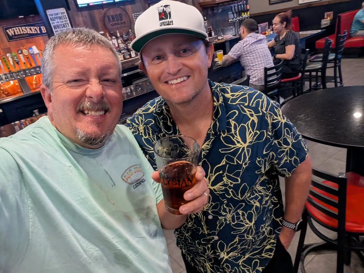
Dinner and drinks with my buddy @jpetramala tonight. So cool sharing stories and more.
 Mike's Weather Page
@tropicalupdate
Talking some weather tonight. Tune in! El Nino special.
 Mike's Weather Page
@tropicalupdate
Friday PM water vapor map. Showing this weekends cold front well. Cooler dry air on the way. Just a teaser though. Colder air arrives next weekend! www.spaghettimodels.com
 Mike's Weather Page
@tropicalupdate
Weekend cold front for Florida. Well most of it. Dewpoints dropping under 70 makes actual 80 degrees almost feel chilly. We Floridians know what I mean haha. Sunday here.
 Mike's Weather Page
@tropicalupdate
Another area in Florida watching for flooding this weekend is the St. Johns near Cocoa. Expected to reach major stage of 17.1 Sunday. NOAA shows 17.2 really starts to enter homes and blocks roads. The river is unique and flows north. And very slow. All of last weeks rains catching up. www.spaghettimodels.com
 Mike's Weather Page
@tropicalupdate
Update on Longo. He's doing great!
Mike's Weather Page
@tropicalupdate
Friday's 11/06/26 "Daily Brew": x.com/i/broadcasts/2jPQmokyrAYvPa
Mike's Weather Page
@tropicalupdate
Still a 'Socks and Flops' official alert! For some. Cold front incoming Florida. Yes. But not all of you. Posted 12 days ago the chances of some cool air this weekend. Half was true. Half was false. 50s are making it to middle state Sunday AM. Even might get some 30s up north. South Florida, however, misses out. We might hit 59 here in Oldsmar. Wooohooooooo. Turn the heat on or not?
 Mike's Weather Page
@tropicalupdate
Frontal line is making the weather today. SPC upping some storm chances for the east coast as it moves in. Brief Tornado chance also mentioned (top left). Clears out for the weekend leaving some cooler dry air behind. www.spaghettimodels.com
 Mike's Weather Page
@tropicalupdate
Took a little ride with Sarah yesterday checking out the Peace River flooding in Arcadia. Tested a new remote roof camera that was better than expected! The river was pretty incredible seeing how high it was. Met some locals. Saw some pretty countryside and sunset. Even some deer too.
 Mike's Weather Page
@tropicalupdate
No Kyle. Chances back to yellow this AM. It is Invest 94. But nothing more. Nothing less. Heading east. CYA. www.spaghettimodels.com

Mike's Weather Page reposted
 WeatherNation
@WeatherNation
HISTORIC FLOODING IN GEORGIA: Drone video shows significant flooding in McCaysville, GA after 10 inches of rain fell overnight. The Toccoa River crested at just over 18 feet today, reaching a historic high and surpassing the previous record of 17.75 feet set in 1990. #gawx #flashflooding
Mike's Weather Page
@tropicalupdate
Flooding at the Peace River Campground in Arcadia, Florida tonight. Waters in Major Flood Stage over 16 feet. Just a couple feet a few days ago.
Mike's Weather Page
@tropicalupdate
Flooding at the Peace River Campground in Arcadia, Florida tonight. Waters in Major Flood Stage over 16 feet. Just 3 feet a couple days ago.
Mike's Weather Page
@tropicalupdate
LIVE Storm Chasing FLORIDA Rivers! x.com/i/broadcasts/2JQXXvMJoOJMyR
Mike's Weather Page
@tropicalupdate
LIVE Storm Chasing FLORIDA Rivers! x.com/i/broadcasts/2QnllMvjMlZqvL
Mike's Weather Page
@tropicalupdate
Fall in Florida. Thanks to Hobby Lobby and Walmart. Got our little setup for this year up. I'll be chasing pumpkins around the yard if El Nino brings some storms lol.

Mike's Weather Page reposted
 Jordan Steele
@JordanSteele
Gas EXPLOSION live on @weatherchannel this morning. While covering the big flooding in TN/GA -- this propane tank lit up right towards that SUV @StephanieAbrams @JimCantore
Mike's Weather Page
@tropicalupdate
Historic flooding overnight north Georgia south Tennessee. Toccoa River here breaking records rising over 15 feet overnight. Tons of water rescues. Downtowns underwater. Happens fast. And sometimes not even in the forecast. www.spaghettimodels.com
 Mike's Weather Page
@tropicalupdate
Fog season is brewing. Warm muggy air ahead of cold fronts bring out the monsters and zombies. Be careful out there in the mornings not sure what you will see... or think you will see.
 Mike's Weather Page
@tropicalupdate
Thursday's 11/05/26 "Daily Brew": x.com/i/broadcasts/2ReMXraBVjWbQk
Mike's Weather Page
@tropicalupdate
11/05 Walking and talking...
Mike's Weather Page
@tropicalupdate
Florida Flooding ongoing in and around Arcadia. Peace River is expected to peak today at 16.5 feet, which could impact up to 60 homes in the area. Not directly impacted by recent heavy rains, but having to deal with the after effects now. Similar to Hurricane Ian when things rose afterwards. www.spaghettimodels.com
 Mike's Weather Page
@tropicalupdate
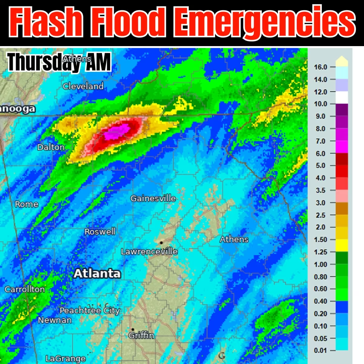
Big story overnight and ongoing. Flash Flood Warnings in northern Georgia, east of the Dalton area. Dozens of water rescues are ongoing as the sun comes up. Almost a foot of rain showing in the mountain areas which is leading to fast accumulations in creeks/rivers.
 Mike's Weather Page
@tropicalupdate
Weather through the weekend. Frontal line working east. Rains today from the Gulf northeastward. Little heavier along the Mid-Atlantic northward tomorrow. Some storms in and around eastern NC Friday. Weekend looking nice for most. South Texas juice builds. Cooler drier air. Fall is here. www.spaghettimodels.com
 Mike's Weather Page
@tropicalupdate
Only in Florida! @Okeechobee Sheriff Office responded to a 10 foot alligator recently inside a Home Depot in Okeechobee, Florida. “We need assistance with an alligator in Aisle 43.” Least the rope and duct tape was close by. All this rain made everything a swamp that's for sure! Over a foot of rain in Okeechobee fell a few days ago. Alligators like this got a little confused.
 Mike's Weather Page
@tropicalupdate
We are one month away! Our annual 'Neighbors Helping Neighbors' benefit party is coming. Raising money for a great cause. And having a ton of fun. Saturday is the big day. Concert at night. Raffle. Cornhole. Meet n' Greet. Weather presentation. Happy Hour. Much more. Make it a day. Or come for a few nights. Families welcome. Come hang with MWP friends and families. Detail link below to book.
🎉 What: Neighbors Helping Neighbors Benefit Party
📍 Where: Camp Margaritaville, Auburndale, Florida
📅 When: Saturday, December 5th
❤️ Why: Neighbors Helping Neighbors Benefit
🏕️ How: Bring an RV, rent a cabin, or come for the day!
www.margaritavilleresorts.com/camp-margaritaville-rv-reso…
 Mike's Weather Page
@tropicalupdate
Future radar the next couple days here. Weak frontal line pushing rain chances eastward. Heavier line starting to show early Friday. Some cooler dry air behind. Sorry SFL not sure you are included... much... with the coolness. www.spaghettimodels.com
Mike's Weather Page
@tropicalupdate
The Peace River near Arcadia could bring some flooding impacts the next couple days. Expected to peak at 16.5 feet. And NOAA shows 16 feet gets up to 60 homes flooded. All this rain is working its way down. www.spaghettimodels.com
 Mike's Weather Page
@tropicalupdate
Season over? New NOAA long range tropics map posted. Not showing any areas of concern into late November. Season officially ends November 30th. www.spaghettimodels.com
 Mike's Weather Page
@tropicalupdate
Wednesday's 11/04/26 "Daily Brew": x.com/i/broadcasts/2RezmeEKmPJWkL
Mike's Weather Page
@tropicalupdate
Morning spaghetti models. NHC spot clearly going east and south of Bermuda. Nothing else cooking. Cheers. www.spaghettimodels.com
 Mike's Weather Page
@tropicalupdate
Wednesday AM Tropical Update. Less than a month remains. NHC bumping chances for maybe Kyle to 50%. Motion would be east away from anyone. No worries. www.spaghettimodels.com
 Mike's Weather Page
@tropicalupdate
Still seeing some cool air make it into Florida this weekend. Just not for everyone. 40s/50s down towards middle state. South stays in the 70s for some as front doesn't make it for everyone. www.spaghettimodels.com
 Mike's Weather Page
@tropicalupdate
Wednesday AM radar. Weak frontal line inching east. Some pockets of rain along the upper Gulf. South Florida flow remains for some. www.spaghettimodels.com
Mike's Weather Page
@tropicalupdate
Historic rains across Florida left disastrous scenes of widespread flooding. Many locals said this was worse than any past tropical system they have ever seen. Here are some videos I took of the area, Palm Bay to Barefoot Bay. It was bad. So many homes flooded. Hundreds of cars left stranded.
Mike's Weather Page
@tropicalupdate
Zoomed in where some of the highest rain totals were the past couple days. 28+ inches officially showing around the Palm Bay area! www.spaghettimodels.com
 Mike's Weather Page
@tropicalupdate
Kyle is that you? NHC bumping chances up this afternoon. Motion staying east so no worries either way.
 Mike's Weather Page
@tropicalupdate
My segment with @foxweather and @BobVanDillen today discussing the Florida flooding. Shared what I saw, with videos of my journey.
Mike's Weather Page
@tropicalupdate
Check out this amazing deal from Firman Power Equipment just for MWP. Having a water pump ready to go can be essential when flooding happens. Especially as we enter an expected wet fall and winter thanks to El Nino. Price includes Free shipping! Thanks Firman crew!
 Mike's Weather Page
@tropicalupdate
Talking Florida flooding with @foxweather Weather at 12:45pm ET.
Mike's Weather Page
@tropicalupdate
BREAKING NEWS: Port Canaveral welcomes its newest cruise ship after all this flooding rain.
 Mike's Weather Page
@tropicalupdate
Tuesday's 11/03/26 "Daily Brew": x.com/i/broadcasts/2YRnNPELKXMaLV
Mike's Weather Page
@tropicalupdate
Over 3 trillion gallons of water fell over Florida the past few days. Crazy to think! Totals here show general idea of totals. Yes 20+ inches plus in spots!
 Mike's Weather Page
@tropicalupdate
Future radar today along with lightning chances. Flow is in from the southeast. Could be some more higher SE totals. WPC showing level yellow 2/4 there. www.spaghettimodels.com
Mike's Weather Page
@tropicalupdate
What failed? Never saw any rainfall models showing what actually fell on the Florida east coast. Most showed 4/5" on the high end. 20" plus actually fell in spots. Flood risk was never above yellow level 2/4 leading up to Monday. Here were some maps on Halloween (Saturday). Just unbelievable what I saw in the Palm Bay area southward.

Mike's Weather Page reposted
 SheliaElaine
@setc72
PSL should have closed school's early on 😳this weather is insane
Mike's Weather Page
@tropicalupdate
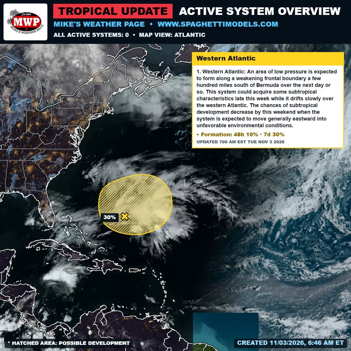
Tuesday AM look at tropics. Yes the season lasts until November 30th. Spot over the western Atlantic at 30%. Should stay south of Bermuda and head off east. No worries. Nothing else showing on the NHC 7 day map. www.spaghettimodels.com
 Mike's Weather Page
@tropicalupdate
Had a pretty special moment today chasing this crazy flood in Florida. Came across an older gentleman with his car stranded in floodwaters near Palm Bay. We tried to get it started. No luck. Offered to take him home. He said yes. Had to help in and out of the Storm Chaser but we did it. The truck is kinda high. Met is wife waiting for him in their garage and yes she was a little worried. I could tell they were happy to be back together. All ended well. We talked a bunch. They are from my mom and dads hometown in Pennsylvania. Shared some stories. And they are big Steelers fan too! Helped as much as I could. Reminded me of my dad so much. Just happy to do a little to hopefully make this terrible situation a little better for them. Glad I was there. Great meeting you sir! Hope everything is ok with your car.
 Mike's Weather Page
@tropicalupdate
So much flooding! So many water rescues. So many locals saying they never seen anything like this. Barefoot Bay, Florida
Mike's Weather Page
@tropicalupdate
Water rescue just now in Barefoot Bay, Florida. Never seen anything like this. 100s of cars flooded. Water in homes. Roads underwater.
Mike's Weather Page
@tropicalupdate
Barefoot Bay, Florida. Every street. Water in some homes. So many cars stranded.
Mike's Weather Page
@tropicalupdate
Insane amount of flooding in and around Palm Bay, Florida. These cars were swept away from flood waters. So dangerous!
Mike's Weather Page
@tropicalupdate
Historic flooding in Palm Bay, Florida.
Mike's Weather Page
@tropicalupdate
Never seen so many cars stranded in water. Palm Bay, Florida.
Mike's Weather Page
@tropicalupdate
Unbelievable flooding. Palm Bay, Florida.
Mike's Weather Page
@tropicalupdate
LIVE Storm Chasing FLORIDA FLOODS! x.com/i/broadcasts/2vypLydgzkXeAE
Mike's Weather Page reposted
 NWS Melbourne
@NWSMelbourne
11:14 AM | A Flash Flood Warning has been issued for portions of St. Lucie County until 1:15 PM EST. Between 4 and 8 inches of rain have fallen. Additional rainfall amounts of 2 to 4 inches are possible in the warned area.
 Mike's Weather Page
@tropicalupdate
Flooding chances increased to Red level 3/4 for today Monday. Heavy rains continue to train from the south. www.spaghettimodels.com
 Mike's Weather Page
@tropicalupdate
Monday's 11/02/26 "Daily Brew":": x.com/i/broadcasts/2JQlKbQzWNRqQm
Mike's Weather Page
@tropicalupdate
11/02 Walking and talking...
Mike's Weather Page
@tropicalupdate
Some pretty big numbers coming in across the Florida peninsula with more to come today. Places showing over 3" here. Several areas with double digits! El Nino falls and winters typically increase Florida flooding. www.spaghettimodels.com
 Mike's Weather Page
@tropicalupdate
Watching tropics. Overnight ensembles. I know it looks like scribble. But tells a lot. New NHC 20% area off the US east coast likely moving off E/NE. And EURO still showing some hints of western Caribbean. That also likely moves off NE if anything. Typical patterns for November if anything tries and spin. www.spaghettimodels.com
 Mike's Weather Page
@tropicalupdate
NHC marking spot in the Atlantic giving it 20% chance this AM. Motion off to the NE likely as midweek front opens the door and lifts it away. Could bring some weather to Bermuda later week. www.spaghettimodels.com
 Mike's Weather Page
@tropicalupdate
Nonstop rains continue across parts of the Florida peninsula. Current Monday AM radar. Slow movement north. East coast still level 2/4 WPC flooding risk today as more rounds expected. Much less overall tomorrow. www.spaghettimodels.com
 Mike's Weather Page
@tropicalupdate
Holy cow. Florida getting some big time rain! Current Sunday 2PM radar.
 Mike's Weather Page
@tropicalupdate
Frontal line this week brewing. Could be storms trying to form Wednesday along the upper Gulf towards the Florida panhandle. Nothing solid yet but just keeping the discussion going. Latest severe chances map here. Line likely weakening as it moves into Thursday for the peninsula. One time it did show better chances. www.spaghettimodels.com
 Mike's Weather Page
@tropicalupdate
Mike the Hype! Posted the EURO for next Sunday a few days ago and it went viral. The idea of cooler temps spread for sure. End of week front still coming. But not as strong. Latest EURO temps for next Sunday here. About 10 degrees warmer. Sorry haha. It happens. But. A few days later could be more chilly with another line coming in. Not posting that. Yet. www.spaghettimodels.com
 Mike's Weather Page
@tropicalupdate
Future radar through Tuesday AM. Paints the idea there will be some heavy areas of rain coming through Florida. Not exact but juice is definitely in the air. Some heavy totals will lead to some isolated flooding. Bucs game looking wet. www.spaghettimodels.com
Mike's Weather Page
@tropicalupdate
Last month watching the tropics and nothing is cooking out there. NHC showing zippo the next 7 days. That area in the lower western Caribbean the EURO has been hinting is less in overnight ensembles. AI still showing nothing there. If anything pops track likely NE. Not a popular area during El Nino so unlikely yes. www.spaghettimodels.com
 Mike's Weather Page
@tropicalupdate
Sunday 8am Florida radar. Current WPC shows most the state and upper Gulf under level 1/4 flooding. With most the Florida east coast under level 2/4 chances. Heavy rain expected through tomorrow at least. www.spaghettimodels.com
Mike's Weather Page
@tropicalupdate
Sunday morning satellite. Things starting to bubble out there. Already some heavy pockets of rain falling. East side still in level 2/4 flooding chance. Lasts through tomorrow at least as all that Gulf juice pushes east. www.spaghettimodels.com
 Mike's Weather Page
@tropicalupdate
 Mike's Weather Page
@tropicalupdate
It wasn't supposed to rain!!!
Mike's Weather Page
@tropicalupdate
Had to modify the skeleton. Wind took him down the other day and broke his arm. Happy Halloween!
 Mike's Weather Page
@tropicalupdate
Latest afternoon EPS model for Sunday rains. Interesting as it still shows chances for both sides of the state. Not what NOAA is showing. Juicy day for someone. www.spaghettimodels.com
 Mike's Weather Page
@tropicalupdate
Saturday afternoon satellite here. Gulf juice bubbling. Upper winds slowly pushing east. Sunday and Monday rain totals inching up there for much of the peninsula. www.spaghettimodels.com
Mike's Weather Page
@tropicalupdate
The annual stocking up of Halloween goodies... for the adult trick or treaters.
 Mike's Weather Page
@tropicalupdate
Future radar through Monday AM. Florida definitely juice increases tomorrow. Some get a lot. Some maybe a little. www.spaghettimodels.com
Mike's Weather Page
@tropicalupdate
Happy Halloween. Need a last minute costume idea? Here ya go!
 Mike's Weather Page
@tropicalupdate
Bigger frontal line still showing this week. Starts midweek middle US with heavy rain and storms. Then keeps moving eastward clearing most the US by the weekend. Cooler and drier air is on tap. Storm potential in question the father east and south it goes. www.spaghettimodels.com
 Mike's Weather Page
@tropicalupdate
Official rain maps usually blend basic ideas. I like looking at operational models like the GFS/EURO here. Gives realistic ideas how isolated areas might get more... or less. Few areas showing 3/4 inches through Monday. Pretty much all of Florida in the mix for something. Now if you don't get any don't get mad at me haha. www.spaghettimodels.com
 Mike's Weather Page
@tropicalupdate
Excessive rainfall maps increased for Sunday and Monday here. Lingering heavy rains expected for most of eastern Florida. Level 2/4 flooding chances. Widespread areas showing several inches. Even possible on the west side. www.spaghettimodels.com
 Mike's Weather Page
@tropicalupdate
One month of Hurricane season to go. NHC tropical update showing nothing the next 7 days. Some EURO ensemble support in the lower western Caribbean. But no AI model support. Motion on that would be NE (away from CONUS). Only spot to kinda know about right now.
 Mike's Weather Page
@tropicalupdate
Good times!!!
 Mike's Weather Page
@tropicalupdate
Great night with my good friends Fran Haasch and Mike Alstott kicking off Octoberfest here in Tampa tonight. Weather was awesome. People were great. Nice meeting so many of you. German beer is great. Cheers!!! @attyfranhaasch @M_A_F_F
 Mike's Weather Page
@tropicalupdate
Halloween is going to be a little breezy Florida. Nothing scary. But maybe adding a little spookiness to the night. www.spaghettimodels.com
 Mike's Weather Page
@tropicalupdate
My unfavorite weekend. Changing the clocks errrr. Now it will be getting dark during the afternoon. YUCK! And to make it worse we have to get up at 2am on Sunday to change them. Tampa sunset is 5:45pm. Too early?
 Mike's Weather Page
@tropicalupdate
Friday's 10/30/26 "Daily Brew": x.com/i/broadcasts/1nxeLMNevybJX
Mike's Weather Page
@tropicalupdate
Been a battle this year with AI vs operational models at times. Looking at overnight ensembles here. EURO looking at a historical hotspot this time of year with 27% showing something moving off NE. AI showing 0%. Casually curious is all. www.spaghettimodels.com

 Mike's Weather Page
@tropicalupdate
Checking in on next weeks frontal line. Latest EURO keeps idea alive. Wed/Thu snapshot here. Strong front builds midweek pushing east. How far into Florida the big question for me. Could be some sneakly El Nino fueled storms as it moves. Interesting feature is this low hanging out over the Atlantic. Likely merges down the road working off to the northeast with front. Might add to NE action. www.spaghettimodels.com
 Mike's Weather Page
@tropicalupdate
Sunday still looking extra juicy across the Florida peninsula. Latest NOAA numbers here. Widespread 1"+. Good day to stay inside and watch some sports it appears. Bucs 1pm. Nascar 2pm. Dark at 5pm (thanks time change). YEP that sounds like a good plan for us.
 Mike's Weather Page
@tropicalupdate
Happy Halloween! Our little setup this year. Booooo!!!
Mike's Weather Page
@tropicalupdate
Big problems at home. My 12 footer fell in last week's winds and lost his shoulder and arm. Not sure what to do...
 Mike's Weather Page
@tropicalupdate
New long range outlook today from NOAA. Showing midweek front line bringing some heavy rain chances. Areas hit hard from Isaias will be dealing with some this weekend, then this a few days later even more. www.spaghettimodels.com

Mike's Weather Page reposted
 FL Division of Emergency Management
@FLSERT
Florida has secured a Major Disaster Declaration for Hurricane Isaias, authorizing Individual Assistance for eight counties: Bay, Escambia, Gulf, Holmes, Okaloosa, Santa Rosa, Walton, and Washington.
This assistance provides critical federal resources to impacted Floridians for housing, home repairs, and other disaster-related needs. Residents can apply at disasterassistance.gov.
This follows the previous approval of Public Assistance for 15 counties to support emergency work and the repair or replacement of disaster-damaged facilities.
We will continue working with our federal partners to ensure impacted Floridians and communities receive the assistance they need to recover as quickly as possible.
 Mike's Weather Page
@tropicalupdate
Hey Tampa Bay area I'll be on with @TheJohnSenning at 2:45pm today talking NASCAR and maybe some weather. 102.5 FM or online. www.theboneonline.com
 Mike's Weather Page
@tropicalupdate
Thursday 10/29/26 Weather: Wet Halloween forecast for some. Storms maybe next week coming with big cold front. Latest here.
Mike's Weather Page
@tropicalupdate
It is an official 'Socks and Flops' alert! Big cold front coming the end of next week Florida. Some temps here on the latest EURO for Sunday AM. Chilly for sure. And some reaches down the state. Are you ready?
 Mike's Weather Page
@tropicalupdate
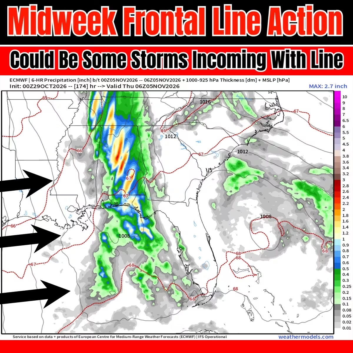
Watching midweek next week. Strong frontal line on radar. Strong storms could be on tap middle Gulf eastward. How far south into Florida the question (later week). www.spaghettimodels.com
 Mike's Weather Page
@tropicalupdate
Thursday's 10/29/26 "Daily Brew": x.com/i/broadcasts/1qGoNYlbaRzKv
Mike's Weather Page
@tropicalupdate
10/29 Walking and talking...
Mike's Weather Page
@tropicalupdate
Rain chances bumping up this weekend across the southeast, especially Florida. Sunday the bigger day with decent totals showing. Timing tricky. But could some storms mixed in. Saturday rains stay west of the Sunshine State. www.spaghettimodels.com
 Mike's Weather Page
@tropicalupdate
Future radar today. Less coverage across the Florida peninsula. Still some flow from the Atlantic as old frontal boundary and weak low pressure reamins. Elsewhere, spotty rains across most the south and east. www.spaghettimodels.com
Mike's Weather Page
@tropicalupdate
Looking ahead. Halloween rains for the upper Gulf pushing east. Pretty much it for eastern US entering next week. More heavy rain out west. Watching middle week return for upper Gulf then southeast. Rains/Storms. www.spaghettimodels.com
 Mike's Weather Page
@tropicalupdate
Go Rays! Been coming here for over 20 years. Both girls first game was when they were two. Here we are. Too many memories to count in this ballpark. Win or lose we already won. So happy to be here. @RaysBaseball #raysup
 Mike's Weather Page
@tropicalupdate
Got some weather brewing later next week. El Nino driving early action towards the southeast and Florida it appears. Severity not clear but consistent idea. Cutoff low pulling up a line of storms working east. Timing will jiggle around but for sure watching. Frontal line storms. Not a Hurricane. www.spaghettimodels.com
 Mike's Weather Page
@tropicalupdate
Come cruise with your MWP family and friends next March on the @Margaritaville at Sea out of Tampa. Amazing rates are locked in for our group. Private cocktail party, free swag, Hurricane presentation with Q&A, and other fun events for our crew. Don't miss out on all the fun!!! Call Kim today.
 Mike's Weather Page
@tropicalupdate
Relentless. Waves and winds have been driving into the Florida east coast for days. High pressure locked in to the north. Low pressure to the south. Nothing to nudge them. Coastal Flood Warnings remain in place for today Wednesday. For all the Florida east coast up into Georgia. Crazy. Some tide values have beat past Hurricanes. www.spaghettimodels.com
 Mike's Weather Page
@tropicalupdate
New NOAA long range tropics map posted. Nothing cooking towards middle November. Nearing the end of season! www.spaghettimodels.com
 Mike's Weather Page
@tropicalupdate
Wednesday's 10/28/26 "Daily Brew": x.com/i/broadcasts/1AxRnZQlMnjxl
Mike's Weather Page
@tropicalupdate
Nothing cooking in the tropics. NHC showing nothing the next 7 days. And long range looking clear. Season does last until November 30th so I will keep things updated. Zippo sounds great to me! www.spaghettimodels.com
 Mike's Weather Page
@tropicalupdate
10/28 Walking and talking...
Mike's Weather Page
@tropicalupdate
Future radar for today. Still weak low pressure over the Bahamas with a lot of rains there. More flow in towards the Florida peninsula today from the Atlantic. General idea here. Some get. Some don't. www.spaghettimodels.com
Mike's Weather Page
@tropicalupdate
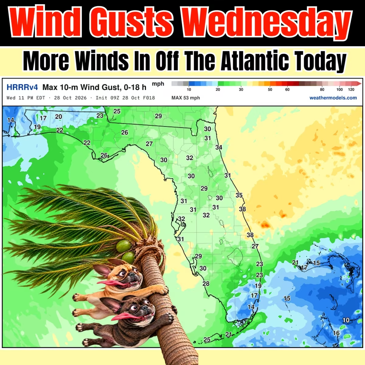
Another windy day across Florida. Things slide up some for the east coast bigger gusts. But expect them to make it through the whole state. East to west flow. Less tomorrow. www.spaghettimodels.com
 Mike's Weather Page
@tropicalupdate
BOO! Looking at this weekend and Halloween. System sliding east and pulling up some Gulf Juice. Saturday rains here showing upper Gulf most likely to get a little wet on Halloween. 🎃 www.spaghettimodels.com
 Mike's Weather Page
@tropicalupdate
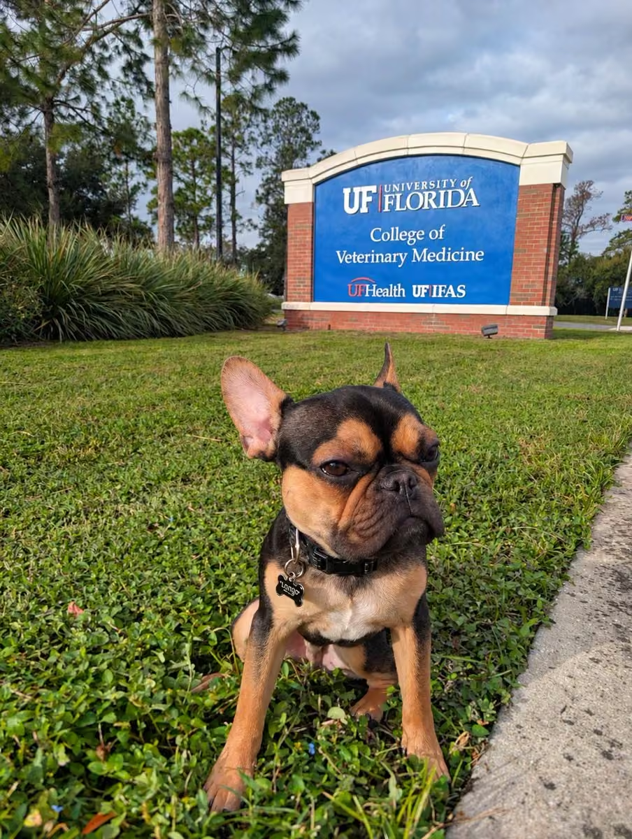
Guess who's coming home! Longo got all his tests back and things are very promising. Much better than what we thought going in. Thank you everyone for the positive words this AM. And a big thanks to UF Gainesville for a great experience. Your team was fantastic.
 Mike's Weather Page
@tropicalupdate
Highest water heights outside a Hurricane since 1994 at Virginia Key, a barrier Island in Biscayne Bay, Miami. Strong winds and full moon boosting numbers up and down the east coast for sure! Today was their 3rd highest behind Irma and Wilma. www.spaghettimodels.com
 Mike's Weather Page
@tropicalupdate
Watching patterns into November. El Nino historically bumps storm chances for the southeast and especially Florida during fall and winter. Usually combining a stronger jet stream and frontal line. EURO hinting idea. Last few runs have. Nothing solid of course but watching curiously. 500mb vorticity map here identifies storm line potential with upper air instability. We will sea. www.spaghettimodels.com
 Mike's Weather Page
@tropicalupdate
Up in Gainesville this AM getting Longo checked out. Little guy has had some stuff going on. We heard UF is great. You got this buddy!!! By the way it's pretty cool up here. 65 brrrrrr.
 Mike's Weather Page
@tropicalupdate
So far 10/10. They are doing a cat scan and additional tests. Waiting in car. Sounds more hopeful than before we got here.
Mike's Weather Page
@tropicalupdate
Talking Florida flooding today with @BobVanDillen and @foxweather. And of course some other stuff. Waiting out Longos visit in Julie's car. So it became the studio today lol.
Mike's Weather Page
@tropicalupdate
Weak low still spinning around the Bahamas. Rain starting to make it's way across lower Florida. Future radar through overnight here paints idea and flow. More tomorrow, then eventually all this pulls out to the northeast, including winds. www.spaghettimodels.com
Mike's Weather Page
@tropicalupdate
Weak low pressure remains over the Bahamas. Wind gusts for today here showing more blowing in from the Atlantic for eastern state. More coastal flooding expected especially during high tide cycles. www.spaghettimodels.com
 Mike's Weather Page
@tropicalupdate
Weak low pressure flow over the Bahamas pushing some rains into Florida the next couple days. Some higher totals showing for some across southeast state. Pulls away later week. www.spaghettimodels.com

Mike's Weather Page reposted
Mike's Weather Page
@tropicalupdate
Getting close to just one month more to go of Hurricane season. Winding down it appears. Overnight 00z Google ensembles here for the Gulf and Caribbean showing 0% chance of anything (in red area). Some good odds right there! www.spaghettimodels.com
 Mike's Weather Page
@tropicalupdate
Ray's. You were amazing when it wasn't serious. Now things flipped when things got serious. Not the same in the WS that's the sad fact. Still love you. But momentum isn't there. Overthinking. Errors. Different lineups. Relievers that aren't normally in the mix. Bats flat. Just seems what got you here isn't here anymore. Not Monday morning quarterbacking. Just thinking out loud. Sad game for sure.
Mike's Weather Page
@tropicalupdate
A MULLET & A BUSCH! Last Talladega post then back to more weather I promise. I know some get annoyed with non-weather posts but oh well. It's what I do. Many awesome memories from this weekend. Family fun number one. Having a car in the race with @FIRMANPower. Hanging with @CarsonHocevar. Meeting a ton of fans and families. This though ranks right up there. @foxweather had me on live from our campsite. Talking weather. And more. Even chugged a @BuschBeer with my mullet on. Pretty sure that's never been done on National TV. As I've grown I've had a few haters. Trying to shut me down. And I guess that's ok and to be expected. I can't thank so many of you fans and sponsors that ignore the critics and still support. Through it all. And still believe. Including FOX who just let's me be me. Pinch me but it's just so crazy to think. This guy. On National TV. Doing what I do. And being who I am. Thank you everyone. Yes I'm reflecting. Yes I chugged a beer. With a mullet. On TV. Feeling satisfied and a little proud of what this MWP thing has all become. Soapbox over. Thank you.
 Mike's Weather Page
@tropicalupdate
Alarm set at 5am. Pack all our crap. Leave 830am. Lose an hour back to eastern. 575 miles. In an RV towing a trailer. Unload. Switch cars. Just made it watch the Rays starting lineup. Not a minute to spare lol. Go Rays!!! Whew.....
 Mike's Weather Page
@tropicalupdate
Incredible weekend with @FIRMANPower at Talladega. Huge thanks for putting Mike's Weather Page on the hood. See us back on the track at Homestead!
Mike's Weather Page
@tropicalupdate
Apparently bones doesn't follow Mike's Weather Page. Posted for days about a windy weekend. Neighbors sent me pictures this AM. Looks like I have to patch a head and an arm when we get home lol. Or maybe he was just celebrating the Bucs win.
 Mike's Weather Page
@tropicalupdate
Future radar the next couple days. Weak low pressure showing with even some spinnage. Models were off and on maybe something developing moving off to the northeast but nothing solid. NHC showing nothing out of it. Incoming rainbands for eastern Florida and definitely the Bahamas on tap. www.spaghettimodels.com
Mike's Weather Page reposted
 Gavin Valenti
@GavinValenti
Didn’t see this coming this morning. Las Olas Boulevard in Fort Lauderdale is flooded from king tides and the full moon. 🌕🌊
Mike's Weather Page
@tropicalupdate
Monday AM look at tropics. Zippo. Looks to stay that way through Halloween. Boo. In a good way. www.spaghettimodels.com
 Mike's Weather Page
@tropicalupdate
See ya next year @TALLADEGA. Always a ton of fun!
 Mike's Weather Page
@tropicalupdate
Weather post. Nothing out there. NHC latest showing zippo next seven days. This takes us into November. www.spaghettimodels.com
 Mike's Weather Page
@tropicalupdate
Hunters Moon tonight! Figured I would put our little guy on this one. Miss ya buddy.
 Mike's Weather Page
@tropicalupdate
 Mike's Weather Page
@tropicalupdate
What is up with this gas saving. Kinda weird. Whole pack running 30% throttle? Then some take off and run crazy fast. Is this racing?
 Mike's Weather Page
@tropicalupdate
20 years later. Time sure does fly. But a million memories in between!
 Mike's Weather Page
@tropicalupdate
Perfect Talladega morning. Go Hurricane Carson Hocevar!
 Mike's Weather Page
@tropicalupdate
Weather. Strong winds from the east off The Atlantic for the southeast and Florida. Big waves remain. Full moon today adding to some height levels. Surfs up! Wave and wind maps here. www.spaghettimodels.com

 Mike's Weather Page
@tropicalupdate
Dega baby. Going hard. It's 2am local. Luckily only 11pm Tampa time. We still going.
 Mike's Weather Page
@tropicalupdate
Been camping at Talladega Superspeedway for 20 years. Used to push the girls down the boulevard in a stroller. Now look at where we are. Circle of life moment. Enjoying things the same but passing the torch. Great to see traditions remain and continue. Having the best weekend with friends and family. And meeting so many awesome folks that follow MWP. Thanks for a great week.

 Mike's Weather Page
@tropicalupdate
We racing at Talladega baby. If you ain't first... you're last! Thanks to @FIRMANPower for putting MWP on the hood. And all that they do!
Mike's Weather Page
@tropicalupdate
Saturday update. Nothing cooking in the tropics. NHC not showing any areas the next seven days. www.spaghettimodels.com
 Mike's Weather Page
@tropicalupdate
So awesome to meet @CarsonHocevar last night here at Talladega. He came over to our campsite and hung out for a long time. Met the girls and was just so chill. Sarah gave him a hug too. He's what you see on TV that's for sure. Thanks everyone to help make it happen.
Mike's Weather Page
@tropicalupdate
The Hurricane came by and hung out at our site. So awesome! Thanks @CarsonHocevar you the man.
 Mike's Weather Page
@tropicalupdate
Watching Ray's from Talladega. Let's go!!! Where you watching at?
 Mike's Weather Page
@tropicalupdate
Hey Florida!!! Spaghetti Model IPA is now in stock at ABC Fine Wine & Spirits across the state. Our annual tropical IPA features Longo on the can. And is a great tasting flavor from TBBC. Get yours this weekend before they are long gone. Cheers!!!
 Mike's Weather Page
@tropicalupdate
We are racing at Talladega tomorrow on the #38 Patrick Emerling NASCAR!! So cool he came by and hung out with us this afternoon. Wish him luck!!! Car looks fantastic!
 Mike's Weather Page
@tropicalupdate
I got pressured from the kids. But I did it! Not going to be a bull rider that's for sure.
Mike's Weather Page
@tropicalupdate
Wild weather setup for the southeast coast, especially Florida. High pressure north. Low pressure south. Windy in the middle. Waves big time. And rains off the Atlantic. www.spaghettimodels.com
 Mike's Weather Page
@tropicalupdate
I'll be on @foxweather at 12:15 ET from the infield at Talladega!
 Mike's Weather Page
@tropicalupdate
Winds up through the weekend and early week from the east thanks to high pressure flow. Wave map here shows maximum heights possible through Monday. Surf up for sure, dude! www.spaghettimodels.com
 Mike's Weather Page
@tropicalupdate
Friday morning look at the tropics. Circling main areas to watch and nothing showing solid to report. Less than 10% of ensembles hint anything. Season does end November 30th so we'll keep watching. But for now zippo out there. www.spaghettimodels.com
 Mike's Weather Page
@tropicalupdate
Love Florida FDOT! Let's go Ray's!!!
 Mike's Weather Page
@tropicalupdate
Need your help. Have @CarsonHocevar the Hurricane come see the Hurricane chaser at Talladega. GEICO Green 1101 infield. Come on. Share. Tag. Whatever lol. Let's do it. Let's make it happen somehow!!! Just a picture and I'm good. I heard he follows me. I would crap. Come on!!!!!!
 Mike's Weather Page
@tropicalupdate
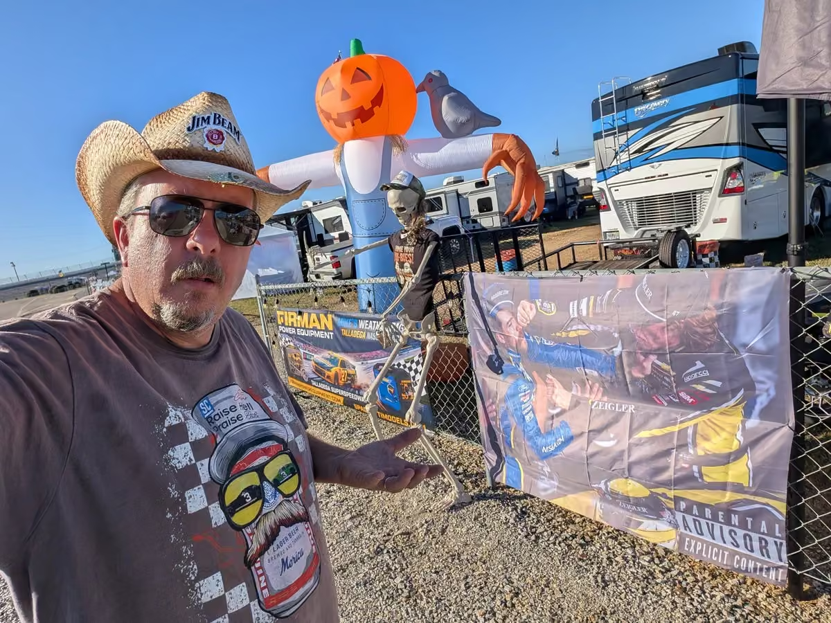
Loud generator or loud music. Music wins. Buy a @FIRMANPower Equipment and I'll turn it down lol.
Mike's Weather Page
@tropicalupdate
OK. I missed an hour of drinking yesterday to update the website and APP for Josephine. Less than 24 hours later she's gone. Come on lol!
 Mike's Weather Page
@tropicalupdate
Rainfall the next 7 days, through next Wednesday. Most across eastern US staying dry. East side of Florida still expecting. www.spaghettimodels.com
 Mike's Weather Page
@tropicalupdate
Traditions. That's what means a lot to us. Been taking the girls through the tunnels at racetracks since they were infants. Sarah today asked me to go for that ride. And of course honk the horn.
 Mike's Weather Page
@tropicalupdate
Looking at next week'ish. Western Atlantic discussions had a maybe spot to watch. Overnight ensemble chances here. No more. Some less. 8% now showing. 92% no. Not stressing on this one yet. www.spaghettimodels.com
 Mike's Weather Page
@tropicalupdate
Morning wood. The boys aren't used to 47 degrees. Me either. Talladega week!
 Mike's Weather Page
@tropicalupdate
Thursday morning look at Subtropical Storm Josephine. Huge wind field that stretches 415 miles from center. Usually what happens with these type systems. Current track and models keep moving off northeast. www.spaghettimodels.com
 Mike's Weather Page
@tropicalupdate
Talking about Subtropical Josephine. Not! Loving some cool Alabama weather. I can see stars!!!
 Mike's Weather Page
@tropicalupdate
Sweet Home Alabama! Ready for a week off the radar. But that didn't happen lol. Just updated the website and APP for Josephine. Dega baby!!!


 Mike's Weather Page
@tropicalupdate
We now have Subtropical Josephine. Nothing changes. Heading northeast. www.spaghettimodels.com
 Mike's Weather Page
@tropicalupdate
Wednesday afternoon NHC update. Invest 93 starting to get a little more organized. Chances up to 70%. Still heading off to the northeast. New little area following at 10%. No biggie on that one. www.spaghettimodels.com

Mike's Weather Page reposted
 NCDOT NC12
@NCDOT_NC12
UPDATE: NC12 is still closed from Marc Basnight Bridge to Rodanthe, and about 800 feet of pavement has now been damaged by forces from the offshore nor'easter. Please stay safe. Avoid travel on NC12 on Pea Island. For travel updates, check drivenc.gov.

 Mike's Weather Page
@tropicalupdate
Invest 93 still at 40% chance this Wednesday AM. Under 1000mb but still attached to that front. Moving off to the northeast. Coastal winds and waves remain. Latest models and look here. www.spaghettimodels.com
 Mike's Weather Page
@tropicalupdate
Heavy rains starting to show on outlook maps for southeast Florida this weekend. Latest here. Stretches over the Bahamas too. www.spaghettimodels.com
 Mike's Weather Page
@tropicalupdate
Annual pit stop on the way to Talladega. Not in Florida anymore! And we are the only ones in shorts and flip flops lol.


 Mike's Weather Page
@tropicalupdate
NOAA with a new Tropics Outlook today highlighting Western Atlantic as a potential spot to watch. www.spaghettimodels.com
 Mike's Weather Page
@tropicalupdate
Latest Tuesday PM update on Invest 93. Still 40% chance. Staying offshore. Heading northeast. www.spaghettimodels.com
 Mike's Weather Page
@tropicalupdate
Heading to @NASCAR @TALLADEGA! Proud to be with my friends from @FIRMANPower and having a car in the Saturday O'Reilly race. Come by our infield campsite and put your name in for a FREE generator. Cheers. Going to be a blast!
 Mike's Weather Page
@tropicalupdate
Rainfall totals for the next 7 days. Notice south Florida and the Bahamas. Low pressure likely upping the rain chances later week into the weekend there. Few ensembles sniffing development but nothing solid to stress with that. Rest of the east staying dry. Nor'easter looking to stay just offshore. And Nascar Talladega looking awesome!!! www.spaghettimodels.com
 Mike's Weather Page
@tropicalupdate
Might be something trying to pop on radar early next week in the western Atlantic. So far most showing another northeast motion. Latest EURO and Google ensembles at 13% yes. 87% no. General area is bringing big rains over the Bahamas and some for SE Florida regardless starting this weekend. www.spaghettimodels.com
 Mike's Weather Page
@tropicalupdate
Had some chatter about the Gulf and Caribbean. Looking at 15 day ensembles here from the EURO and Google and not showing much. Very low chances. Cheers to that! www.spaghettimodels.com
 Mike's Weather Page
@tropicalupdate
Tuesday's 10/20/26 "Daily Brew": x.com/i/broadcasts/1AKEmvapkwVKL
Mike's Weather Page
@tropicalupdate
SpaceX this morning. Another view here from Oldsmar (Tampa Bay). My Android phone seemed clearer than my 360.
Mike's Weather Page
@tropicalupdate
SpaceX this morning. View from Oldsmar (Tampa Bay).
Mike's Weather Page
@tropicalupdate
Awesome SpaceX launch this AM!


 Mike's Weather Page
@tropicalupdate
Invest 93 remains off the Carolina coast this Tuesday AM. Moving off towards the northeast. Overnight NHC chances still at 40%. www.spaghettimodels.com
 Mike's Weather Page
@tropicalupdate
JELLYFISH ALERT: Round 2. This mornings got cancelled. Going to try again tomorrow AM at 6:30am. Clear skies again for many. Moving more SE this time but still a large chunk of the southeast expected to see it. Can't wait!
 Mike's Weather Page
@tropicalupdate
7:04am now
Mike's Weather Page
@tropicalupdate
Our family has been going to Ray's games for 20+ years. My proudest moment was being asked to throw out the first pitch last year here.
Mike's Weather Page
@tropicalupdate
OMG!!!! Nail biter....
 Mike's Weather Page
@tropicalupdate
Talking weather and Ray's today with @BobVanDillen and @foxweather today. Check it out!
Mike's Weather Page
@tropicalupdate
NWS putting out a southeast winter outlook here. www.spaghettimodels.com
 Mike's Weather Page
@tropicalupdate
Low pressure starting to show some spinnage off the east coast. Hanging out a couple more days before taking off northeast. Coastal winds/waves remain. NHC watching for possible formation from it. Impacts the same regardless. www.spaghettimodels.com
Mike's Weather Page
@tropicalupdate
Deepening low pressure off the Atlantic coast the next few days. Max wave heights here showing some coastal action likely. And all the way down to the Florida east coast. Surfs up! www.spaghettimodels.com
 Mike's Weather Page
@tropicalupdate
What does an El Nino winter look like? This is a basic idea. That southern jet stream keeping cold fronts a little more colder. Rains a little more heavy. And storms. Some tornadic. Florida especially in the mix with this setup. www.spaghettimodels.com
 Mike's Weather Page
@tropicalupdate
Monday's 10/19/26 "Daily Brew": x.com/i/broadcasts/1rxmqpyYdXdxy
Mike's Weather Page
@tropicalupdate
Rainfall totals this week through the weekend. Atlantic coastal low looks to keep the rains offshore. Florida juice lifting towards the southeast side of the state later in the forecast. Heading to Talladega NASCAR and looks like we hit the jackpot weather wise!
 Mike's Weather Page
@tropicalupdate
Chilly Monday AM for most. 20s and 30s taking over a big chunk of the US. With some 50s inching into middle Florida. South Florida not playing along. Key West near 80 degrees. www.spaghettimodels.com
 Mike's Weather Page
@tropicalupdate
A look at future radar the next couple days. Atlantic low staying off the coast. Few showers might make the OBX. Florida peninsula flow has some Atlantic isolated showers rolling in. Likely not making it to the western side of the state. www.spaghettimodels.com
Mike's Weather Page
@tropicalupdate
Looking at ensembles the next 15 days. Current NHC marked spot off the Atlantic east coast heading off northeast. Few ensembles hinting western Atlantic earlier next week. Most off the coast and moving northeast too. Nothing else showing solid in the Gulf/Caribbean to stress about as we head into November. www.spaghettimodels.com
 Mike's Weather Page
@tropicalupdate
Chances at 40% could see maybe something subtropical off the east coast. Bringing more coastal winds and waves a few days before it moves off to the northeast. www.spaghettimodels.com
 Mike's Weather Page
@tropicalupdate
JELLYFISH ALERT. Another chance Monday AM to see the crazy exhaust of SpaceX. Look to the east. It will be awesome!
 Mike's Weather Page
@tropicalupdate
Powerful Hurricane Isaias made landfall along the Florida panhandle in October 2026. And Mike was in it! See the before, during, and after video showing it all. The early forecasting and thoughts. The countdown to landfall. The incredible journey with dramatic stories and footage along the way. Come ride along inside the Storm Chaser as Mike heads into the storm straight into the eyewall. See the damages. And the devastation brought to so many. Hurricanes definitely change lives.
Full video here: youtu.be/0PZpQChN1uA
 Mike's Weather Page
@tropicalupdate
Cold front clearing things out. Rainfall totals through next week here. Most staying dry. Including @TALLADEGA Superspeedway which we will be at whooohooooooo! Lingering rains for south Florida remain and some on the Florida east coast is about it. OBX coastal low juice too but nothing showing too high there. Hoping @CarsonHocevar stops by to say hi. www.spaghettimodels.com
 Mike's Weather Page
@tropicalupdate
Looking ahead at 10 day ensembles. East coast low pressure area showing on many. Moving off to the northeast likely down the road. Gulf and Caribbean keeping things virtually zippo. Season ends November 30th officially. www.spaghettimodels.com
 Mike's Weather Page
@tropicalupdate
Lingering low expected to hang off the east coast a few days. Eventually moving off to the northeast likely. Coastal impacts remain as it spins in some weather. NHC keeping chances at 30% for formation. www.spaghettimodels.com
 Mike's Weather Page
@tropicalupdate
Enjoying this cool morning outside with the boys. Feels great!

Mike's Weather Page reposted
 Space Jellyfish Alerts
@spacejellyalert
Space jellyfish alert!
The Bandwagon-5 rocket launch from Florida on October 19, 2026 at 6:30 AM EDT could produce a space jellyfish. This occurs when a rocket and its expanding exhaust plumes are illuminated by the sun and observers are in local darkness.
NOTE: This rare and unique trajectory is modeled as a best-guess estimate. This prediction may be inaccurate for distant viewers.
The rocket will enter sunlight 02m55s after launch.
Viewing locations, peak elevation while rocket is lit by the sun, and approximate viewing direction:
🟢 Nassau • 66° • NE
🟢 Jacksonville • 28° • SE
🟢 Havana • 25° • ENE
🟢 Charlotte • 14° • SSE
🟡 Virginia Beach • 13° • S
🟡 Kingston • 30° • NE
🟡 Nashville • 7° • SE
🔴 Panama City • 8° • NNE
🔴 Columbus, OH • 5° • SSE
🔴 Managua • 5° • NE
🔴 New Orleans • 9° • ESE
🔴 Mérida • 8° • ENE
🔴 New York • 6° • S
🔴 Providenciales • 77° • NE
See a detailed prediction for your location: jellyfish.johnkrausphotos.com
Information as of 2026-10-17 20:04 UTC. Weather pending. Forecast does not model cloud cover or atmospheric conditions.
 Mike's Weather Page
@tropicalupdate
My buddy Harrison doing some storm chasing today from the Outer Banks. It was rocking and rolling there!
Mike's Weather Page
@tropicalupdate
Ready to get scared. Having fun with the family as the sun goes down.... and temperatures too. I only like to come here when it feels like fall. And it sure does. Thank you everyone for the birthday wishes today. Means so much!
 Mike's Weather Page
@tropicalupdate
Coastal low ensembles. Majority move off to the northeast. NHC marked the spot at 20%. www.spaghettimodels.com
 Mike's Weather Page
@tropicalupdate
Coastal low hanging off eastern US this week marked by the NHC. 20% chance of some development. Most models have move off to the northeast. Nor'easter style impacts regardless. www.spaghettimodels.com
 Mike's Weather Page
@tropicalupdate
Sunday morning wakeup temps. Florida pretty split. Possible 40s up north. Middle 70s down south. What side are you on? Front passing though now. www.spaghettimodels.com
 Mike's Weather Page
@tropicalupdate
Typhoon Champi is nearing Guam and the Northern Mariana Islands. Current satellite. 140mph winds! 200k plus live there.
 Mike's Weather Page
@tropicalupdate
First snow of the season for the Smokies! From LeConte Lodge overnight. I'm ready to chase some snow!
 Mike's Weather Page
@tropicalupdate
Tropics. Still some buzz about the Gulf. What does Google say? Here ya go. They say 0% chance the next 10+ days. Cold front taking the headlines. Have a great weekend. Go Rays. www.spaghettimodels.com
 Mike's Weather Page
@tropicalupdate
Drinking coffee. Reliving memories. We sometimes forget. Sitting here on my 53rd birthday I'm reflecting. Watching. Families at the beach. Putting sunscreen on. Stressing about the day ahead. Couples walking up and down the beach. Young with a long future ahead. Older just chilling. Soaking up the fresh day ahead. Birds effortlessly living their best life. Soon to end with a world that will go on. An ocean. Calm now. But waiting on the next storm. One that covered the seat I'm at now. With a beach. That onced raced NASCAR. That has seen it all. That will outlive us all. Just wondering. What's ahead. Where I have been. The path I've led. What's next. Who knows. But I'm happy. Content. No regrets. Number one thought right now is we have two great girls. Raised them right. Proud of who they have become. Hope I've been the best dad. My parents. Loved them everyday. They are who I am. Miss my mom. Talk to Dad everyday. He already emailed me this AM. Julie. 25 years. Wow. We have been through it all. Wouldn't change a thing. I'm happy. She's kept me at peace. Inline. Comfortably numb if you know what I mean. So many memories. Thank you everyone here at Mike's Weather Page. 22 years doing what I love. Sharing weather. Sharing shenanigans. Sharing life. I feel I've made some impacts along the way. To the young and to the old. I hope at least. Not sure where tomorrow will lead but the past has been a blast. Feeling thankful. Blessed. Content. My mom had a picture in the house I grew up in that said: Take time among the hours to smell the flowers. For some reason I remember seeing that often. I guess it means slow down. Relax. I need to start trying. Going to soak in this moment now. Listen to the waves. And chill. Sometime rare I need to do more. Have a great day.
 Mike's Weather Page
@tropicalupdate
Any guesses where tonight? My favorite is finding these local joints. Best time ever!!!
Mike's Weather Page
@tropicalupdate
Tracking weather. Chasing storms. Things I love to do. And want to do more. Goal is to produce high quality videos. Showcasing before, during, and after the storm. So excited to release 'Through the Eyes: Isaias' soon. Here is a teaser.
Mike's Weather Page
@tropicalupdate
Tropics? Nothing officially from the NHC showing. And I'm not seeing anything worth mentioning. Gulf? 5 out of 167 ensemble models say maybe. That's 97% no. Not sure why there's buzz on the Gulf out there. But disregard. I'll mention anything that might be of interest. Right now zippo. Cheers. www.spaghettimodels.com
 Mike's Weather Page
@tropicalupdate
NOAA just released their upcoming winter outlook. El Nino impacts likely. Extra wet for the southeast. Warmer up north. www.spaghettimodels.com

 Mike's Weather Page
@tropicalupdate
Florida cold front arrives overnight and heads through most the state Saturday. Big winds expected. Overnight for the panhandle first then southbound as the day marches on. www.spaghettimodels.com
 Mike's Weather Page
@tropicalupdate
What did you think of the flying Tesla? Everything from 'Back to the Future' and 'Knight Rider' is coming true! Craziest thing ever.
 Mike's Weather Page
@tropicalupdate
Cold front sliding down into Florida. Some rains expected for some. Future radar here into Sunday paints idea. Lingers around for south Florida. Cooler air is on the way! www.spaghettimodels.com
Mike's Weather Page
@tropicalupdate
Happy Friday!
 Mike's Weather Page
@tropicalupdate
Friday 10/16/26: Weather in a Nutshell. What's cooking out there?
Mike's Weather Page
@tropicalupdate
Friday NHC Tropical Update. Nothing cooking out there in their 7 day outlook. Inching towards November. Cold fronts making headlines now. Have a great weekend! www.spaghettimodels.com
 Mike's Weather Page
@tropicalupdate
Heartbreaking story from Hurricane Isaias. While Storm Chasing I ran across a home that was completely destroyed. No walls. No roof. Personal belongings everywhere. I heard a voice yelling 'Mike'. Turns out the family follows Mike's Weather Page and invited me up to share their story. Brought me to tears what I saw, and what I heard. The purpose of this GoFundMe is to raise money for Laura Dean and her family. Also met her dad and her son. Such great people. They lost so much. Including their vehicles from the storm. I was blessed to meet this wonderful family and want to help. All money we raise will go to them. Let's show the weather world we can all come together to help. Neighbors Helping Neighbors. Hoping to write a big check to them from all of us from MWP! Please share!!!
Donate link:
www.gofundme.com/f/helping-a-family-impacted-from-hurrica…
Mike's Weather Page
@tropicalupdate
Little video on this story:
Mike's Weather Page
@tropicalupdate
Leftover front might spin up some type of low pressure off the east coast next week. Models sniffing a little more on idea. Will bring big winds regardless OBX northward through the week. Latest ensembles from EURO/Google here showing lows under 1000mb. 58% say yes. Most keep off the coast then move off to the northeast. Named or not we will sea. BTW nothing is cooking in the Gulf/Caribbean. Seeing chatter on that. But I am not seeing anything worth mentioning. www.spaghettimodels.com
 Mike's Weather Page
@tropicalupdate
Cold front bringing the weather the next few days. Frost/Freeze up north. Leftovers hanging over the Atlantic upping winds. And lingering line ups the rains for south Florida. www.spaghettimodels.com
 Mike's Weather Page
@tropicalupdate
This Ray's ump has missed so many calls... Crazy. We need a run!!!
Mike's Weather Page
@tropicalupdate
Just got him up. Those that know... know. Hurricane season over?
 Mike's Weather Page
@tropicalupdate
Cold front rolling southbound this weekend. Winds will be picking up Florida. Batten down Halloween! Gusts here through Saturday PM. Sunday AM likely windy with extra big waves from the Atlantic. www.spaghettimodels.com
 Mike's Weather Page
@tropicalupdate
Frontal line leftovers next week showing over the Atlantic. EURO keeps a low pressure area close to the coast midweek here. Some are farther east. Worth mentioning. Likely keeping northeast winds strong regardless for several days through the week, Outer Banks northward.
 Mike's Weather Page
@tropicalupdate
Thursday's 10/14/26 "Daily Brew": x.com/i/broadcasts/1AKEmvrVrzYKL
Mike's Weather Page
@tropicalupdate
Thursday tropical update. Shhhhhhh.
 Mike's Weather Page
@tropicalupdate
Cold front coming this weekend Florida. Yes it is true. Sunday AM temps here showing widespread 50s making it into the peninsula. With some 60s dipping deep. I got wood. Ready to break out the new firepit. www.spaghettimodels.com
 Mike's Weather Page
@tropicalupdate
Latest ENSO outlook heading towards summer next year. El Nino lasting through the winter is certain. A turn towards a more neutral pattern appears to be coming. Usually means more unpredictability with Hurricane season. Sometimes more. Sometimes less. Thats weather in a nutshell.
 Mike's Weather Page
@tropicalupdate
Front coming through this weekend for the southeast. South Florida with some bigger rains. Totals here the next 5 days. Temp outlook showing a nice little cooldown too. www.spaghettimodels.com

Mike's Weather Page reposted
 Brent Shavnore
@brent_shavnore
Wow! We served over 600 breakfast and lunch plates today! Thank you to everyone who stopped by. The turnout has been incredible!
We’re restocking and getting ready for dinner, and burgers are on the menu tonight!
If you or someone you know needs a free, hot meal, please come by the SouthState Bank parking lot on Highway 90 in Milton. We’ll keep cooking and serving until we run out of food!
Our community has been through so much this week, and we’re happy to do our part to help. ❤️
Mike's Weather Page
@tropicalupdate
STANDING IN A HURRICANE!!! Intense video of 100+ mph winds and blinding rains from Ft. Walton Beach, Florida. Battled the elements outside the Storm Chaser as I captured the powerful eyewall of Hurricane Isaias. The 360 camera got an amazing perspective here. The skeleton did too...
Mike's Weather Page
@tropicalupdate
Raising money for a good cause. And having some fun while doing it. Come plan to part of our 3rd annual 'Neighbors Helping Neighbors Benefit' Saturday December 5th at @campmarg_aub Camp Margaritaville Auburndale. Details below. Proceeds going to help a family we met impacted by Hurricane Isaias. Will be having a raffle, happy hour party, concert, cornhole, karaoke, food, and fun for the whole family. Make a few days out of it if you want. We are! Camp or Cabin. They got you covered! www.margaritavilleresorts.com/camp-margaritaville-rv-reso…
 Mike's Weather Page
@tropicalupdate
Wednesday's 10/14/26 "Daily Brew": x.com/i/broadcasts/1qxvveyzLklxB
Mike's Weather Page
@tropicalupdate
SPC latest Tornado reports from Isaias. Always tough to establish actual eyewall winds vs. confirmed Tornadoes, as the presence is similar with winds/damage. But outside the eye it is more clear. Officially there are 47 total reports. Most in GA/SC/NC. Only 1 in Florida.

Mike's Weather Page reposted
Brent Shavnore
@brent_shavnore
FREE BREAKFAST FOR THE COMMUNITY THIS MORNING!
We’re out at SouthState Bank on Highway 90 in Milton, cooking up fresh bacon, hot breakfast sandwiches, and serving smoothies for anyone who could use a good meal this morning!
If you’re in the area, please stop by, grab some breakfast, and let us take care of you for a change. Everything is completely free!
Please share to help spread the word! Our community has been through a lot, and we’re here to help however we can. ❤️
Mike's Weather Page
@tropicalupdate
Surfs up dude! High pressure bringing in some big winds this weekend off the Atlantic. Wave map here Sunday showing idea. Going to be some big ones for sure. www.spaghettimodels.com
 Mike's Weather Page
@tropicalupdate
It is a hot one out there today across the south and east. Bunch of places might break records the next couple days. Some with their latest 90s of the season. High pressure locked in. This also keeping things extra dry through the weekend. www.spaghettimodels.com
 Mike's Weather Page
@tropicalupdate
New long range tropics map posted. Nothing showing into November. Cheers to that! Season officially ends November 30th. But with El Nino maybe things are officially done. We will sea. www.spaghettimodels.com
 Mike's Weather Page
@tropicalupdate
Go Ray's!!!
 Mike's Weather Page
@tropicalupdate
Received this nice email from local police during Hurricane Isaias. Thank you so much for writing. Always great to run into all of you when out on the 'chase'!
 Mike's Weather Page
@tropicalupdate
Intense winds from Ft. Walton Beach, Florida in the eyewall of Isaias. Storm Chaser helped protect me so I could get the video outside the truck.
Mike's Weather Page
@tropicalupdate
Tuesday AM power outages. Lineman have been working overtime getting things back online! www.spaghettimodels.com
 Mike's Weather Page
@tropicalupdate
Tuesday's 10/13/26 "Daily Brew": x.com/i/broadcasts/1DGleVgrELDJL
Mike's Weather Page
@tropicalupdate
Upcoming weather. Signs of winter sneaking south. Frost and Freeze spreading wide. Some rains expected early week into Florida. High pressure flow and frontal line pushing the juice in. www.spaghettimodels.com
 Mike's Weather Page
@tropicalupdate
Windy weekend ahead for the south and east. High pressure gradient and frontal line helping push in east winds. Gusts here through Saturday and Sunday. www.spaghettimodels.com
 Mike's Weather Page
@tropicalupdate
Tuesday AM NHC Tropical Update. Nothing cooking. Far Atlantic spot never had a chance. Down to 0%. Season does officially last until November 30th in case you are wondering why I would post anything. Putting up the 12 foot skeleton (finally). www.spaghettimodels.com
 Mike's Weather Page
@tropicalupdate
Jellyfish! View from Tampa this AM. Incredible!!!


 Mike's Weather Page
@tropicalupdate
Jellyfish alert tomorrow Tuesday AM. Clear skies likely so many will likely sea!!! Look to the east.
 Mike's Weather Page
@tropicalupdate
Hurricane Isaias reported winds and rains.

 Mike's Weather Page
@tropicalupdate
The moment a transformer blew up next to us! Around Niceville, FL.
Mike's Weather Page
@tropicalupdate
Great to be on with @foxweather and @BobVanDillen today discussing Isaias. They shared a lot of my footage from the storm.
Mike's Weather Page
@tropicalupdate
Had a pretty emotional moment today in Pensacola Beach. Saw this condo completely destroyed. Roof gone. Rooms gone. And this gentleman just sitting there (90 years young). Pleasantly sitting. With complete destruction all around him. He waved. I waved. Then I hear 'Mike'. Video coming next of one of the most touching stories I've ever witnessed Storm Chasing.
 Mike's Weather Page
@tropicalupdate
Thanks for supporting if you can! www.gofundme.com/f/helping-a-family-impacted-from-hurrica…
Mike's Weather Page
@tropicalupdate
Spirit. Courage. Hope. Pain. Love. Every emotion was felt today with this wonderful family from Pensacola Beach. Isaias tried to take it all. They didn't let it. Was inspired hearing their story. Seeing their smiles. Watching neighbors helping neighbors. Was covering the damage and saw this man. Sitting in destruction. On a porch that once was. We shared a wave. Took a picture. Then I heard a voice. Mike!!! It was his daughter. She invited me up to see the destruction. To share their story. Her son was recovering what he could. Walking up and down the stairs. Picking through the piles. She is a big MWP fan. She smiled. We hugged. For a brief moment everything was OK. I helped as much as I could. And then we said goodbye. But it's not goodbye. The story will continue. Every year we end the year with a 'Neighbors Helping Neighbors' benefit party. And today it was clear. It was a sign. We will be helping. Please stay tuned for details this week. For a way to hopefully make a little positive impact in what they lost today. Thank you.
Mike's Weather Page
@tropicalupdate
Thanks for supporting if you can! www.gofundme.com/f/helping-a-family-impacted-from-hurrica…
Mike's Weather Page
@tropicalupdate
Rainfall this next week. Diagonal flow stuck across middle US. Little bit of front backs up for south Florida. Most everyone else across the south and east staying dry. And a little cool. www.spaghettimodels.com
 Mike's Weather Page
@tropicalupdate
I will be on @foxweather at 1:15pm ET for Isaias coverage.
Mike's Weather Page
@tropicalupdate
Hurricane Isaias Damage Imagery. Few houses with roof damage in Pensacola Beach circled. Zoom in and see the whole upper Gulf coast areas after the storm here: storms.ngs.noaa.gov/storms/isaias_2026/index.html
 Mike's Weather Page
@tropicalupdate
Monday's 10/12/26 "Daily Brew": x.com/i/broadcasts/1AxRnZkpNlXxl
Mike's Weather Page
@tropicalupdate
Overnight look at latest ensembles on anything brewing in the tropics. Chances went down even more. Now showing only 6% of EURO/Google members. That is 94% no. Some buzz out there the past couple days on something brewing so wanted to keep you posted. www.spaghettimodels.com
 Mike's Weather Page
@tropicalupdate
Monday AM Tropical Update. Spot way out in the Atlantic at 20%. Not heading west. Likely will just fizzle out there. Nothing else showing. Let's end the season today! www.spaghettimodels.com
 Mike's Weather Page
@tropicalupdate
THANK YOU!!! Thank you everyone for this journey. I am just some dude that loves weather. Who loves people. Who loves this life. I never claim to know anything. Or everything. Or to be better than anyone else. I just do me. A one man band. Sitting in my chair. At a little desk in Oldsmar. Or in my Chevy in a storm. This storm. Hurricane Isaias. Holy cow. Was asked to be on TV during landfall Prime time. YES PRIME TIME! CNN. FOX. NBC. Yes all three. During the same hour. Has this every happened to anyone before? No politics. Just weather. I get crap when I am on one. Or the other. Some unfollow because of this. But guess what. I don't care what side you are on. Its people. Its humans. Its weather. That is the truth. Thank you so much to everyone that follow. To CNN/FOX/NBC for having me on for Hurricane Isaias. Hope I helped some of you along the way. This storm. Or others. Cheers! @OutFrontCNN @livenowfox @NBCNews
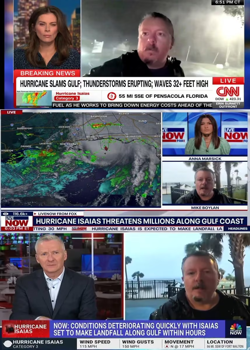 Mike's Weather Page
@tropicalupdate
Hurricane Isaias. Met so many people I can't even guess how many. I love talking. Listening. Sharing. Thank you so so much for trusting and being a part of MWP. Love doing this. Love all of you! See ya next time...
 Mike's Weather Page
@tropicalupdate
Hurricane Isaias crashed a UFO in Pensacola Beach! The winds were pretty intense indeed.
 Mike's Weather Page
@tropicalupdate
Hurricane Isaias. Some cool perspectives and sounds from top of the Storm Chaser as we drove through it.
Mike's Weather Page
@tropicalupdate
Sunday storms ongoing. Tornado Warnings popping thanks to leftover Isaias. 2pm radar here. Whole area is under Tornado Watch as lines move through. www.spaghettimodels.com
 Mike's Weather Page
@tropicalupdate
Future Sunday radar. Watching Isaias spin away. Still some rain and storms to come. See you again in six years. www.spaghettimodels.com
Mike's Weather Page
@tropicalupdate
Very low chances showing now. But enough to mention. Kinda same idea if anything pops. Using my percentage map of 1000mb and under only 12% say yes. 88% say no. And tracks are everywhere. So no stress at all. Some were asking. Seeing some chatter. Seems after every storm the conversation spikes on what's next. I'll keep an eye on things. If anything looks interesting I'll for sure post. Have a great Sunday. www.spaghettimodels.com
 Mike's Weather Page
@tropicalupdate
Isaias still spinning this Sunday morning coming down. Water vapor map on left showing juice all the way to Florida. SPC storm chances still high on right for today. www.spaghettimodels.com

Mike's Weather Page reposted
 Jimmy Patronis
@JimmyPatronis
Good morning, everyone. As we begin recovering from Hurricane Isaias, please stay safe. Keep generators outside, stay away from downed power lines, and check on your neighbors.
We’ll get through this together, but don’t let a preventable mistake turn into a tragedy.
Mike's Weather Page
@tropicalupdate
The skeleton made it through his first hurricane!
Mike's Weather Page
@tropicalupdate
Some Hurricane Isaias damage from Pensacola Beach.
Mike's Weather Page
@tropicalupdate
Pensacola Beach, FL
Mike's Weather Page
@tropicalupdate
Pensacola Beach, FL
Mike's Weather Page
@tropicalupdate
Gulf Breeze, FL
Mike's Weather Page
@tropicalupdate
Out and about checking things out. We are streaming live the next couple hours. Tons of trees are down. Lots of power lines. And I don't hype...
Mike's Weather Page
@tropicalupdate
LIVE Storm Chasing HURRICANE ISAIAS x.com/i/broadcasts/1DxLdZpmMjwxm
Mike's Weather Page
@tropicalupdate
Leftover Isaias still bringing some heavy rain. And storms. Latest look from the SPC for the weekend here showing areas to maybe watch. www.spaghettimodels.com
 Mike's Weather Page
@tropicalupdate
Isaias still bringing the rain and some storms. Future radar for today Saturday showing general idea of flow. Still some pulling up from the Gulf northward from behind. www.spaghettimodels.com
Mike's Weather Page
@tropicalupdate
Almost one million without power this Saturday AM across Florida, Alabama, and Georgia. Power customers, not people. Isaias leaving it's mark for sure. www.spaghettimodels.com
 Mike's Weather Page
@tropicalupdate
After landfall we started driving towards Pensacola and as expected, tons of trees were down, along with power lines. Daylight is going to be interesting. Currently back at the hotel, with no power of course.
Mike's Weather Page
@tropicalupdate
INTENSE!!! Inside the eyewall of Hurricane Isaias at Ft. Walton Beach. View from the Storm Chaser as I battled the storm.
Mike's Weather Page
@tropicalupdate
Took some back roads driving back to Pensacola and as expected trees are down everywhere, along with power lines. Daylight will reveal widespread impacts likely.
Mike's Weather Page
@tropicalupdate
You can't park there! Crazy driving up on this outside Navarre. Four campers on their side!
Mike's Weather Page
@tropicalupdate
In it! Fort Walton Beach!
Mike's Weather Page
@tropicalupdate
LIVE Storm Chasing HURRICANE ISAIAS x.com/i/broadcasts/1vKpPNozYbVKE
Mike's Weather Page
@tropicalupdate
Live from Navarre, FL. Waiting on Major Hurricane Isaias. It's getting crazy windy!
Mike's Weather Page
@tropicalupdate
LIVE Storm Chasing HURRICANE ISAIAS x.com/i/broadcasts/1kKzDPewegrJv
Mike's Weather Page
@tropicalupdate
Major Hurricane Isaias is about 100 miles south of us. Winds are really picking up!!! In Navarre, FL. Streaming live.
Mike's Weather Page
@tropicalupdate
Radar getting in range. Look at that lightning! Not weakening. Still officially 120mph. I'm in Navarre, FL. 3pm CDT time. www.spaghettimodels.com
 Mike's Weather Page
@tropicalupdate
LIVE Storm Chasing HURRICANE ISAIAS x.com/i/broadcasts/1DGleVPVBoNJL
Mike's Weather Page
@tropicalupdate
Pensacola Beach getting windy. My skeleton agrees.
Mike's Weather Page
@tropicalupdate
LIVE Storm Chasing HURRICANE ISAIAS x.com/i/broadcasts/1oJMvNAvABwxQ
Mike's Weather Page
@tropicalupdate
Florida getting ready for Major Hurricane Isaias. Thousands of lineman lined up and ready to go. Awesome to see!
Mike's Weather Page reposted
 Allan Huffman
@RaleighWx
Trend east continues with 12z GFS/UKMET/CMC etc. Landfall could be between Fort Walton Beach and Seaside. Landfall may be at Destin/Miramar Beach now. #isaias
 Mike's Weather Page
@tropicalupdate
OK folks things are getting real. They closed the Waffle House in Gulf Breeze, FL. They know...
 Mike's Weather Page
@tropicalupdate
LIVE Storm Chasing HURRICANE ISAIAS x.com/i/broadcasts/1qKDzWePQZeJV
Mike's Weather Page
@tropicalupdate
Latest 11am CDT NHC update. Track was bumped east (black line). Almost mirroring the Google DeepMind now. Big impacts ahead for Florida... landfall and towards the east. After that things spread north. www.spaghettimodels.com
 Mike's Weather Page
@tropicalupdate
Florida ain't messing around! The state is ready for Major Hurricane Isaias. Never seen so many lineman ready to rock n' roll. Word is 5000+ trucks just here alone. Escambia County near Pensacola.
Mike's Weather Page
@tropicalupdate
Morning update from the hotel lobby in Pensacola. Storm Chasing Isaias. Some latest thoughts. Updates will change so stay tuned to local NWS/NHC. www.spaghettimodels.com
Mike's Weather Page
@tropicalupdate
A look at the latest. Major Hurricane Isaias. Track is confident. Watch those areas to the east showing on current satellite here. Tornadoes always possible in these. Timing puts landfall just after sunset tonight. High tide and new moon will add surge. Impacts before. Impacts way north. And impacts well east. Widespread power outage expected. Tropical Storm winds extend 185 miles from center. Hurricane winds 30 miles from center. New update soon. www.spaghettimodels.com
 Mike's Weather Page
@tropicalupdate
LIVE Storm Chasing HURRICANE ISAIAS x.com/i/broadcasts/1vJpPNebykOJE
Mike's Weather Page
@tropicalupdate
Hurricane Isaias getting stronger. Stronger than forecast. Now 120mph. Pressure 959mb. Storm Surge numbers have increased near landfall and to the east. Now up to 9 feet expected. www.spaghettimodels.com
 Mike's Weather Page
@tropicalupdate
Hurricane Isaias. Latest Friday AM Spaghetti Models and NHC cone. Google DeepMind and HCCA and NHC have settled close to one another. Possible Major Hurricane nearing landfall likely. This is going to end up with some significant impacts for some. Listen to local authorities and take this seriously if in the path. Currently 110mph and likely strengthening. www.spaghettimodels.com in
 Mike's Weather Page
@tropicalupdate
Hurricane Isaias has continued to organize overnight. Those hurricane high end models I keep sharing appear to be correct. Now 110mph. Pressure 963mb. Clear eye. Solid convection and presentation. Official forecast now reaches 120mph before the coast. And likely strong CAT 2 mentioned. Latest Hurricane models aren't baking down. Major Hurricane possible. Track hasn't changed much. Shear as I have learned is hard to predict and forecast impacts. Those that follow know that's been my talking point. Next several hours things get tweaked. Overall impact ideas still the same. Just might increase for some. www.spaghettimodels.com
 Mike's Weather Page
@tropicalupdate
Digesting... models. And more. Cheers from Pensacola. Big day tomorrow. I'm ready!
 Mike's Weather Page
@tropicalupdate
Thursday 10pm CDT NHC update on Isaias. Winds have increased to 105mph winds. Expected to reach Major now at 115mph before some slight weakening before landfall. Track remains close to previous they mention. Going to be sneaky for some. www.spaghettimodels.com
 Mike's Weather Page
@tropicalupdate
Thursday 10pm CDT NHC update on Isaias. Winds have increased to 105mph winds. Expected to reach Major now at 115mph before some slight weakening before landfall. Track remains close to previous they mention. Going to be sneaky for some. www.spaghettimodels.com
 Mike's Weather Page
@tropicalupdate
Thursday night 00z spaghetti models on tropicaltidbits.com. Tracks tightening up. Looking like a little bump east. www.spaghettimodels.com
 Mike's Weather Page
@tropicalupdate
Hurricane Isaias IR satellite Thursday night. Getting more organized it appears. Spinning for sure. Convention building. Riding on top of the infamous Gulf Loop Eddy. Extra warm water for fuel. Holding off shear for now. New NHC update at 10pm CDT. www.spaghettimodels.com
Mike's Weather Page
@tropicalupdate
The day before hurricanes have the most amazing sunsets. Tonight was no different. Heading towards Isaias nearing Pensacola.

 Mike's Weather Page
@tropicalupdate
LIVE Storm Chasing HURRICANE ISAIAS x.com/i/broadcasts/1yxBePaAwopJN
Mike's Weather Page
@tropicalupdate
Update from the Storm Chaser as we head into Hurricane Isaias. Here's the latest update Thursday PM as we head west across I-10. Winds are now 100mph. www.spaghettimodels.com
Mike's Weather Page
@tropicalupdate
Tornadoes! Aggressive Nadocast forecast for Hurricane Isaias bottom. SPC also showing idea top. Conditions might allow little more chances, especially on the eastern side. www.spaghettimodels.com
 Mike's Weather Page
@tropicalupdate
Eye see you! Thursday PM satellite as the sun goes down. Isaias now with an eye. Winds up to 100mph. www.spaghettimodels.com
 Mike's Weather Page
@tropicalupdate
Thursday NHC 5pm update. Winds now up to 100mph. Little tick east. Expected to peak at 110mph then some weakening. Strong winds expected inland along with eastern side of cone. Tornadoes likely to watch on the eastern side into Saturday. www.spaghettimodels.com
 Mike's Weather Page
@tropicalupdate
Not a forecast. Latest Thursday afternoon 12z Google DeepMind models here. They continue on that east side of the NHC cone. New track out at 5pm ET. Satellite imagery a little less impressive recently. Storm likely dealing with shear. Maybe cycling for next round of convection. Or maxing out.

Mike's Weather Page reposted
Allan Huffman
@RaleighWx
With the shift east in the 12z models. Here is the latest dotcast. Most models for #isaias now east of the FL/AL border. I am going for Landfall at Gulf Breeze, Florida as a low end cat 2. But the trend is east.
 Mike's Weather Page
@tropicalupdate
Latest Thursday afternoon spaghetti models for Hurricane Isaias and NHC current cone. Tighter confidence in track with agreement inside the cone. Remember impacts likely outside the cone with any tropical system. Eastern side especially with this one. www.spaghettimodels.com

Mike's Weather Page reposted
 Walton County Sheriff's Office, Florida
@WCSOFL
HAPPENING NOW IN THE @WCBCCFL MEETING: Commissioners have voted that there will be mandatory evacuations in Walton County beginning at noon today for zones A, B, & C, at the recommendation of @WaltonCountyEM.
KNOW YOUR ZONE: experience.arcgis.com/experience/61aa14758c8b42bfa3a5607d…


Mike's Weather Page reposted
Allan Huffman
@RaleighWx
Updating my "dotcast" as the 12z models come in. Certainly a shift east so far from the GFS/ICON/CMC/UKMET. Likely will adjust my landfall point further east in my afternoon update. #isaias
 Mike's Weather Page
@tropicalupdate
Coming to see you Hurricane Isaias. Storm Chaser is ready and we are on the road. Dug out the original flip flops for the chase. They took last year off. Ready for one more ride.

Mike's Weather Page reposted
 NWS Storm Prediction Center
@NWSSPC
Here are our Key Messages for Friday (10/9) and Saturday (10/10).
 Mike's Weather Page
@tropicalupdate
Thursday 11am ET NHC update on Hurricane Isaias. Still strengthening. Similar track as before. Expected to peak at 110mph with some weakening before landfall. NHC: "Isaias is expected to remain a dangerous hurricane through landfall, and gusty winds are expected well inland after landfall given the anticipated expansion of the wind field and accelerating forward speed of the storm." Winds now 85mph. Pressure 975mb. Moving ENE at 10mph. www.spaghettimodels.com
 Mike's Weather Page
@tropicalupdate
SPC Storm Prediction Center showing storm chances here for Friday into Saturday. Yes overnight. Tornados always possible with tropical systems, and this one is no different. Maybe even more. The tail I call it. Or trailing feeder bands showing here. They can be the ones to watch thus the increased chances Saturday when Isaias is well inland. www.spaghettimodels.com
 Mike's Weather Page
@tropicalupdate
Thursday's 10/08/26 "Daily Brew": x.com/i/broadcasts/1AGRnZrdwBVGl
Mike's Weather Page reposted
 National Water Center
@nwsnwc
The National Water Center has issued the morning Tropical National Flood Hazard Outlook for Hurricane Isaias, valid through 7:00 AM CDT on Thursday, October 15, 2026. More information is available at: water.noaa.gov/operations/fho #isaias
 Mike's Weather Page
@tropicalupdate
Hurricane Isaias getting stronger this Thursday AM. Hurricane Hunters finding pressure has dropped to 975mb. Winds still at 80mph. Winds usually catch up after pressure drops. Current IR satellite. www.spaghettimodels.com
 Mike's Weather Page
@tropicalupdate
Latest Thursday AM NHC update on when you might start seeing Tropical Storm force winds. Feeder bands extend well north of the the actual center so these happen earlier than landfall. Thus the closures, evacuations, etc you might see beginning early. 105mph Hurricane the last update just offshore on approach. Colors BTW are percentage chances on getting TS winds. www.spaghettimodels.com
 Mike's Weather Page
@tropicalupdate
The latest Thursday 06z Hurricane Models here on tropicaltidbits.com. Back to showing deep pressure agreement nearing landfall. All weaken 'some' on approach but as the NHC has noted how much will this lower impacts. All these near CAT3 weakening to near CAT2. Still stronger than the official NHC forecast. NHC calling for 105mph just offshore. How much shear interacts is the biggest question as it nears. www.spaghettimodels.com
 Mike's Weather Page
@tropicalupdate
Latest Thursday AM look at Hurricane Isaias. Still strengthening. Expected to peak at 110mph. A little weakening before landfall. NHC overnight track similar to prior. Matching tracks of the Google DeepMind and HCCA. EURO inching closer to these. Expanding wind field expected towards landfall spreading impacts more inland and to the east. Website updated with all the latest. www.spaghettimodels.com
 Mike's Weather Page
@tropicalupdate
Latest Thursday AM key messages from the NHC. No huge changes overnight. Isaias expected to strengthen with that turn to the north. Huge impacts likely. www.spaghettimodels.com
 Mike's Weather Page
@tropicalupdate
New NHC update. Isaias now a Hurricane. First one of the Atlantic season. Winds at 75mph. Pressure down to 982mb. www.spaghettimodels.com
 Mike's Weather Page
@tropicalupdate
A zoomed in look at the latest Wednesday 11pm ET NHC advisories. Next update at 5am. Hurricane expected soon with winds expected to remain above 100mph towards landfall. Lots to watch the next 24 hours. How much it strengthens. How much it weakens with wind shear ahead.
 Mike's Weather Page
@tropicalupdate
NEW CONE! Wednesday 11pm ET NHC update on Isaias. Hurricane Warnings, Storm Surge Warnings, Tropical Storm Warnings are now up. Winds 70mph. Pressure 988mb. Moving ENE at 9pmh. Still expected to reach 110mph. Some weakening before landfall. Major impacts regardless. Wind field expected to expand bringing impacts farther east and inland north. www.spaghettimodels.com
 Mike's Weather Page
@tropicalupdate
New NHC track coming at 11pm. Previous NHC cone and center here in black. Purple is the Google DeepMind and its ensembles. Last year it was the top performing model. This year doing well also. NHC noting that and partly why its gone against king EURO. Blue is the HCCA which was also very good in prior years. So the NHC is close to these. Will see if any more ticks east at 11pm. Thinking will be close the same. www.spaghettimodels.com
 Mike's Weather Page
@tropicalupdate
Hurricane Hunters are inside Isaias right now. Pressure has dropped to 988mb. Despite the odd appearance we don't normally see, the storm is getting stronger. As expected. New NHC cone and graphics at 11pm ET. www.spaghettimodels.com
 Mike's Weather Page
@tropicalupdate
Latest Wednesday PM look at rains expected and flooding potential from Isaias. Double digits possible for some. Friday into Saturday the biggest days. www.spaghettimodels.com
 Mike's Weather Page
@tropicalupdate
Wednesday PM update. Latest zoomed in look at the NHC cone. And some spaghetti models. Black line NHC. Purple line Google. Blue HCCA. Those two are the favored models by the NHC. And lately most accurate. www.spaghettimodels.com
 Mike's Weather Page
@tropicalupdate
Wednesday's 10/07/26 "Daily Brew PM": x.com/i/broadcasts/1AxRnZrlOkaxl
Mike's Weather Page
@tropicalupdate
Wednesday 10/07/26 Tropical Update: The latest on developing Isaias in the Gulf. Hurricane forecast to hit the upper Gulf soon. Models trending a little east bringing more impacts to Florida now.
Mike's Weather Page
@tropicalupdate
Storm Surge forecast has increased in spots per the latest Wednesday 5pm ET advisory. Now extending through Tampa Bay. Big Bend also bumped up. This likely due to the small shifts east and expected strength. New moon adding to the numbers too. www.spaghettimodels.com
 Mike's Weather Page
@tropicalupdate
Latest Wednesday NHC 5pm track update. Isaias strengthening. Pressure 994mb. Winds 65mph. Track bumped east again. Still expected to become 110mph. Some weakening before landfall. NHC mentions CAT 1/2 on most models for landfall. Hurricane Watches now extend inland (pink). Tropical Storm watches (yellow). www.spaghettimodels.com
 Mike's Weather Page
@tropicalupdate
We asked for it. We got it. And then some. Current Wednesday afternoon radar. Florida peninsula continues to be extra moist and juicy. Weekend starts to lighten up. Some. Might have classic fast moving tropical rainbands thanks to Isaias. www.spaghettimodels.com
 Mike's Weather Page
@tropicalupdate
Latest Wednesday PM 18z Spaghetti Models on tropicaltidbits.com. Couple more agreeing with the Google DeepMind (yellow). Overall idea getting tighter. 12z EURO just ran and it bumped a little east and more in line with these. Seems like the Louisiana idea is the biggest outlier right now.
 Mike's Weather Page
@tropicalupdate
Wednesday afternoon 12z Hurricane models are coming in on tropicaltidbits.com. Little weaker on approach overall this run. Big swings in thinking on expected shear on approach. Weakening is expected. But how much. And how strong will storm be before it reaches. NHC mentioning impacts remain either way. Hurricane Hunters in the storm now. Isaias is strengthening as expected. Hurricane expected.
 Mike's Weather Page
@tropicalupdate
Hurricane Hunters are currently inside investigating Isaias. Pressures are falling pretty quick as storm tries to stack and start taking shape. Wednesday 2pm update at 997mb. Winds 50mph. More intensification through the evening very likely. www.spaghettimodels.com
 Mike's Weather Page
@tropicalupdate
Wednesday NHC idea on timing of winds. This shows when you might start seeing Tropical Storm force. Friday for many. This likely will speed up any coastal evacuations, school closures, more. Outer feeder bands start to reach landfall well before the actual center of a storm does. Website updated with all the latest. www.spaghettimodels.com
 Mike's Weather Page
@tropicalupdate
Latest Wednesday noon spaghetti models and NHC cone. NHC track has been nudging east each update. EURO (red) has constantly been the western outlier and is now outside the NHC cone. Google DeepMind (purple) has been the eastern outlier and seems others are starting to follow. Next NHC track update at 5pm ET. Hurricane still expected. Impacts expected well outside the cone and eastern side of track. Website updated with all the latest. Live tonight at 6pm ET. www.spaghettimodels.com
 Mike's Weather Page
@tropicalupdate
Keeping up with model trends. The HCCA and TVCN are model blends that are very useful in tracking. Both have trended eastward some the past few advisories. The NHC almost mirroring the HCCA its last update. Little wiggles still likely. But nothing major expected. Impacts remain regardless to watch for as the center line is just a visual to give idea. Thanks @btangyWx. www.spaghettimodels.com
 Mike's Weather Page
@tropicalupdate
Lighter lines old forecasts. Darker blue recent. Post was about the trends eastward the past day. NHC center now Florida/Alabama line (close to that).
Mike's Weather Page
@tropicalupdate
NHC Storm Surge Forecast for Isaias. New moon adding to the numbers. 5-7 feet possible in orange! Know your zone. Evacuate if told to do so. Added state links to my site to help with needed information. www.spaghettimodels.com
 Mike's Weather Page
@tropicalupdate
NEW CONE! Hurricane Watches are now up along the upper Gulf in pink. Tropical Storm Watches in yellow. Latest Wednesday track here. Little nudge east again. NHC talking rapid intensification possible. Still showing peak at 110mph before some weakening towards landfall. But they note winds might not come down much. So IMO don't think hearing weakening minimizes impacts. www.spaghettimodels.com
 Mike's Weather Page
@tropicalupdate
Wednesday's 10/07/26 "Daily Brew": x.com/i/broadcasts/1qxvveErPLzxB
Mike's Weather Page
@tropicalupdate
Current Wednesday AM satellite. Definitely getting the 'look'. Hurricane Hunters are in. Much better data for the models to digest. Track and intensity throughout the day will get more detailed. Hurricane forecast for the upper Gulf coast remains. www.spaghettimodels.com
 Mike's Weather Page
@tropicalupdate
Always a big focus on landfall. But what happens after? HWRF and HAFS here shows how things continue. Still under 1000mb pressure well inland. Spiraling rain and storms continue. Many well east. And some isolated storm cells remain in the Gulf that get pulled up into. These can last throughout Saturday even into Sunday to watch. Isolated Tornadoes always a chance. Note a few feeder bands might make the Florida peninsula. Some Storm Surge likely makes it to the Big Bend. Those asking for Tampa Bay area likely not much IMO. New moon yes will add some higher waters regardless. Things start to go downhill Friday upper Gulf areas. www.spaghettimodels.com
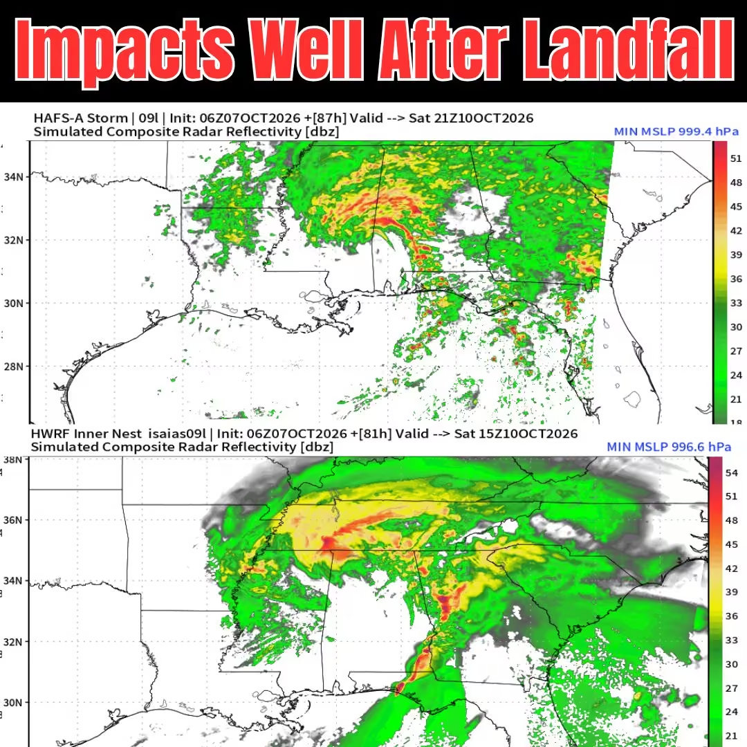 Mike's Weather Page
@tropicalupdate
Latest NHC Wednesday AM cone zoomed in. With some models. Hurricane impacts extend well past center. And often well outside the NHC cone, east side especially. NHC updates cones at 11am/5pm/11pm/5am ET. Cones wiggle and wobble. Important to keep aware. Watching today and tomorrow for possible rapid intensification. Expected to be near Major Hurricane per last NHC update. Some weakening before landfall. But enough to matter? Some Hurricane models showing stronger than the NHC. Lots to watch. Surge likely an issue with new moon in place. Flooding rains of course. And Tornadoes. Especially from the spinning feeder bands in off the Gulf. More east side than west. www.spaghettimodels.com
 Mike's Weather Page
@tropicalupdate
Isaias is organizing this Wednesday AM. Current satellite showing increased convection. Current spaghetti models and NHC cone here. The cone is not impact areas. It is where the center of the storm could go. Impacts expected well east and northward inland. Hurricane Hunters in route. Some Hurricane models still show Major Hurricane on approach later Friday. www.spaghettimodels.com

Mike's Weather Page reposted
Jimmy Patronis
@JimmyPatronis
🚨☔️ STORM ALERT FOR NW FLORIDA
As Tropical Storm Isaias makes its way through the Gulf later this week and into the weekend, it’s time to prepare.
✅Secure your property.
✅Check your supplies.
✅Make a plan for your family and pets.
✅Take photos of your home and belongings before the storm.
Stay informed, look out for your neighbors, and stay safe. God bless. 🇺🇸
Mike's Weather Page
@tropicalupdate
Overnight Wednesday Hurricane models keeping that idea of a Major Hurricane approaching landfall. Latest here on tropicaltidbits.com showing concerning pressures with all four agreeing. Timing later Friday into Saturday. Some weakening on approach yes, not sure it will matter much. High surge likely pushing north and to the east, especially with a new moon. NHC did bump Wednesday AM track east. These models historically read intensity well. Confidence higher when all agree. Track history not as perfect but still paints idea what we could be dealing with. Eastward impacts well eastward expected, reaching the Florida Big Bend at least. The Gulf in October. And an 'I' storm. We watch close. www.spaghettimodels.com
 Mike's Weather Page
@tropicalupdate
Wednesday AM NHC track update. We now have Isaias. Intensity forecast bumped to 110mph before some weakening (not much). Intensity models showing even stronger. Little shift eastward this run. NHC continues adding discussion on east side impacts from center. Lots to watch upper Gulf towards northern Florida. Faster moving system will also bring impacts well inland. www.spaghettimodels.com
 Mike's Weather Page
@tropicalupdate
Those that follow MWP know I like to look long-range at the weather. Especially Hurricanes. Text my buddy Harrison last Wednesday September 30th about this chance of Hurricane Isaias. Had that feeling. He got a flight home and will be Storm Chasing with me. Took him on our Nor'easter chase and he got some great video footage. We head out Thursday. Getting a new sticker for the Storm Chaser. Will be live for the Daily Brew Wed/Thu at 9:19am ET. And also tomorrow night at 6pm. Lots to digest as models come together. Upper Gulf preparing for a Hurricane. Website and APP updated with the latest. www.spaghettimodels.com
 Mike's Weather Page
@tropicalupdate
NEW CONE. Tuesday 11pm NHC track update on TD#9. Expected to quickly strengthen. 100mph Hurricane still forecast. Shear on approach might help weaken some. NHC talks on expanding size meaning impacts well east of center. www.spaghettimodels.com
 Mike's Weather Page
@tropicalupdate
Latest Tuesday night 00z spaghetti models for TD#9 on tropicaltidbits.com. Some nudge west. Google DeepMind still eastern outlier. Expected to be Hurricane Isaias. New NHC track update at 11pm ET. www.spaghettimodels.com
 Mike's Weather Page
@tropicalupdate
When can you start to see Tropical Storm force winds? Latest idea and map from the NHC showing times. Feeder bands will extend to the north and east well ahead of the actual center. Will impact things like schools, travel, some evacuations, all starting Friday early.
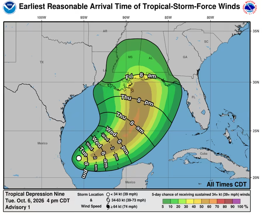 Mike's Weather Page
@tropicalupdate
Tuesday's 10/06/26 "Daily Brew PM": x.com/i/broadcasts/1RKZzBQLXMNKB
Mike's Weather Page
@tropicalupdate
Tuesday 10/06/26 Tropical Update: Hurricane Isaias is developing in the Gulf! Here's the latest.
Mike's Weather Page
@tropicalupdate
Important NHC Key Messages on expected Hurricane Isaias in the Gulf. www.spaghettimodels.com
 Mike's Weather Page
@tropicalupdate
New cone! We now have Tropical Depression #9. NHC expecting a Hurricane. They show 100mph winds Friday. So yes something definitely to watch in the days ahead upper Gulf. www.spaghettimodels.com
 Mike's Weather Page
@tropicalupdate
What is making this turn north? High pressure moves in and builds over the western Atlantic. This clockwise flow helps steer north. And blocks the Florida peninsula. Another low to the west also helping steer. Confidence high on this turn coming. Upper Gulf from middle Louisiana to the Florida panhandle watching close.
 Mike's Weather Page
@tropicalupdate
Latest Tuesday evening 18z spaghetti models on tropicaltidbits.com. Same basic idea on tracks, turning eventually north in a couple days. DeepMind ensembles continue to stay little more east (not pictured). Might have a NHC cone soon.
 Mike's Weather Page
@tropicalupdate
Heads up Pinellas County. Got some vorticity showing on radar that might indicate a waterspout. Heading kinda northeast but hard to pinpoint exact direction. Keep an eye open on isolated storms incoming this afternoon/evening. www.spaghettimodels.com
 Mike's Weather Page
@tropicalupdate
Latest Tuesday 12z EURO running now. Interesting takeaway last night and now again today. Model keeps it strengthening on approach. EURO trending west of others. Usually this model is low on intensity prediction. Lots to watch. Don't focus on centerline as impacts likely well east of center. www.spaghettimodels.com
 Mike's Weather Page
@tropicalupdate
Latest Tuesday 12z higher resolution Hurricane models on tropicaltidbits.com coming in. Some weakening before 'landfall' yes. But is it enough to reduce impacts. Likely not too much. Notice the feeder bands off to the east. Some will likely reach the Big Bend area. Some south towards the peninsula too. HAFS models stronger than earlier. HWRF still showing 950mb range. Timing is this Friday/Saturday. Usually these four models are good at predicting intensity. Especially when they are all close. Dry air will be wrapping in likely yes. Heaviest and strongest stuff center eastward. Plus new moon this weekend will up any Storm Surge impacts. Lots to watch. www.spaghettimodels.com
 Mike's Weather Page
@tropicalupdate
Bunch of heavy rain coming in off the Gulf this Tuesday afternoon. And some storms. SPC highlighting west central Florida to watch. Possible isolated waterspout and/or tornado they mention. www.spaghettimodels.com
 Mike's Weather Page
@tropicalupdate
Current Tuesday midday look at Invest 92 and latest spaghetti models. Definitely looking feisty from above. Lots to watch the next few days. www.spaghettimodels.com
 Mike's Weather Page
@tropicalupdate
Hurricane? Rapid Intensification? Things to watch for IMO yes. System already getting some spin. Planting the seed I call it. Convection solid. Moisture stream seems to last through the week. Addition fuel a developing tropical system needs. And waters. Gulf running a little warmer than normal. And a large loop eddy awaits. These have historically aided in Gulf development. Shear is expected yes. That could help weaken on approach yes. But to what extent. Some of the higher resolution hurricane models teasing this idea of a stronger storm. Historically believable. Not hyping. Not wishcasting. Just laying out there some thoughts. Turn to the north eventually very likely as high pressure builds in the east blocking and steering. Next couple days will be interesting to watch unfold. www.spaghettimodels.com
 Mike's Weather Page
@tropicalupdate
Tuesday's 10/06/26 "Daily Brew": x.com/i/broadcasts/1OGwbnoYmZbKB
Mike's Weather Page
@tropicalupdate
NHC bumping chances of tropical development this Tuesday AM to 90%. Isaias the next name on the list. Some models sniffing Hurricane in a few days with upper Gulf impacts starting as early as Friday this week. Lots to watch. Especially being the Gulf in October. Shear expected near landfall. But what it does before means a lot. Sloppy system brings more impacts eastward towards Florida if it goes that route. www.spaghettimodels.com
 Mike's Weather Page
@tropicalupdate
Latest Tuesday 06z models on tropicaltidbits.com. This is where it gets tricky. I am a model guy. I don't try and outsmart them. When they stay consistent and agree you start to believe. These particular models have been good over the years predicting intensity. Meet in the middle maybe? But couple are strong yes. Hurricane Isaias is a possibility to watch for heading into the weekend. Gulf waters are warm and above 'average'. Shear is ahead yes. But what it does before it reaches that means a lot. Something to watch for sure. NHC up to 90% this AM. Hurricane Hunters head in today. Remember most bigger impacts are east of center. More shear more impacts east. www.spaghettimodels.com
 Mike's Weather Page
@tropicalupdate
Latest Tuesday AM ensembles on weathernerds.org. EURO top. Google bottom. Some chances this shifts east. AI trending that way. Main EPS top left staying west. Big questions on intensity. Higher resolution models sniffing real Hurricane chances. Timing soon with impacts beginning as early as this Friday upper Gulf. www.spaghettimodels.com
 Mike's Weather Page
@tropicalupdate
Tuesday AM satellite on Invest 92. Bubbling away. Amazing how that area in the BOC can help spin up tropical systems. Hurricane Hunters are in today. Will we see Isaias? www.spaghettimodels.com
Mike's Weather Page
@tropicalupdate
Tuesday AM spaghetti models on Invest 92 in the lower Gulf on tropicaltidbits.com. Looking more organized on satellite. Hurricane Hunters head in today. Next name Isaias. First Hurricane of the season?
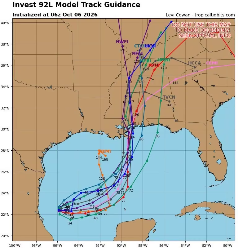 Mike's Weather Page
@tropicalupdate
Most exciting I've ever seen it here at the Rays. So awesome!
Mike's Weather Page
@tropicalupdate
Go Ray's!
 Mike's Weather Page
@tropicalupdate
Invest 92 will have to wait. It's all about the Ray's tonight. Woohooooo. Tailgating. Doesn't get much better! #raysup
 Mike's Weather Page
@tropicalupdate
We now have Invest 92 in the lower Gulf. Chances have increased to 80% formation from the NHC. Next name Isaias. General idea is slow movement a couple days eventually heading off NE'ish. Lots to watch yes with this one. www.spaghettimodels.com
 Mike's Weather Page
@tropicalupdate
Monday 10/05/26 Tropical Update: Something is brewing in the Gulf. Need to watch for sure. Here's the latest.
Mike's Weather Page
@tropicalupdate
Monday NOON satellite on weathernerds.org. Tropical system starting to brew it appears. Slow movement expected a couple days before a general turn NE likely. Watching things close. www.spaghettimodels.com
Mike's Weather Page
@tropicalupdate
Latest Monday AM ensembles on our NHC marked spot in the Gulf on weathernerds.org. EURO top. Google bottom. Some shift east in these. Will have a couple days at least to organize before a turn N/NE it appears. NHC at 70% this AM on chances. Looking juicy.
 Mike's Weather Page
@tropicalupdate
Monday's 10/05/26 "Daily Brew": x.com/i/broadcasts/1PKqrNeMQePGb
Mike's Weather Page
@tropicalupdate
Lot of chatter on end of week/weekend wind shear. Latest numbers here. Typically these numbers would have big impacts on any developing tropical system. Meaning helping it stay weak/weaker. And pushing rains/storms eastward. NHC bumping lower Gulf spot to watch to 70% this AM. So definitely something to keep an eye on. Few ensembles not seeing this shear hurting too much. Logic says those are wrong. But we never ignore outliers we have learned over the years. www.spaghettimodels.com
 Mike's Weather Page
@tropicalupdate
NHC bumping Tropical chances up to red 70% this Monday AM. Area getting more model support with several ensembles showing Isaias forming this week. Lots to watch it appears the next few days as this evolves. Timing later week into the weekend we could start to see Gulf coast impacts. www.spaghettimodels.com
 Mike's Weather Page
@tropicalupdate
Not a forecast. Just a discussion. But always get asked whether a system might be more than a Tropical Storm. Developed this graphic with option to show only systems under 990mb. Looking at latest EURO EPS/AI and WNV3 chances at 24% yes... 76% no. Wind shear the big topic and impacts to any developing system later week. Always watching the Gulf in October. www.spaghettimodels.com
 Mike's Weather Page
@tropicalupdate
Monday morning look at radars. Still showing outages here in red. These have been offline now over two days. Been reading the NWS still has access internally to images, just the data can't be sent out. That means many APPs are showing 'nothing' when indeed 'something' is there.
 Mike's Weather Page
@tropicalupdate
Rainfall forecast for today and this week ahead. Some big numbers still showing. Stalled front combing with Tropical juice pulling N/NE. As we know sometimes these are overdone but they are not backing down either. Watching weather this week for sure along the upper Gulf and Florida. www.spaghettimodels.com
 Mike's Weather Page
@tropicalupdate
NHC bumping chances up to 50% overnight on lower Gulf spot. Models eventually move it N/NE. So far most keeping on the 'weaker' side with possible Gulf Coast impacts later week/weekend. As always we will watch close on any changes or outliers. www.spaghettimodels.com
 Mike's Weather Page
@tropicalupdate
Latest Sunday PM idea from ensembles on potential Gulf area this week. Chances here around 35% of something. NHC officially at 40%. Some pull north. Some stay south. Not a lot of confidence yet. Timing later week so a couple days to really get a grasp. No stress yet. Will digest much more in the AM. www.spaghettimodels.com
 Mike's Weather Page
@tropicalupdate
Chances are up. Orange 40% now. www.spaghettimodels.com
 Mike's Weather Page
@tropicalupdate
Rain chances are up the next several days as lingering frontal line lingers across the upper Gulf down into the Florida peninsula. Daily flood outlooks here. www.spaghettimodels.com
 Mike's Weather Page
@tropicalupdate
Latest EURO EPS ensemble blend with highest chances yet for the lower Gulf this week to watch. Shear the big unknown to the north if it will allow something stronger, or just keep 'whatever' sloppy pushing the rains eastward as it treks up. NHC has area marked at 30%.
 Mike's Weather Page
@tropicalupdate
Happy Sunday. Lobster for breakfast. Why not!
 Mike's Weather Page
@tropicalupdate
Estimated look at radar for Sunday. Lingering front bringing lots of potential juice up from the Gulf. Some will get. Some won't. Thats weather haha. But potential is there for a lot upper Gulf. Peninsula flow west to east. www.spaghettimodels.com
Mike's Weather Page
@tropicalupdate
Heavy rains expected today up from the Gulf. Flood Advisories are up in green. Flash Flood Emergency ongoing in red. Future radar shows a big surge of moisture. Radars are down so many won't see it coming. www.spaghettimodels.com
 Mike's Weather Page
@tropicalupdate
Overnight Sunday 00z ensembles have trended higher for lower Gulf spot. Now 30% of their members showing a 1000mb or less system this week. These are the EURO EPS/AI and Google WNV3 runs. Shear is the biggest question to the north and what impact it will have. Sometimes these become sloppy rainmakers that push rains eastward. But something to watch it appears yes. www.spaghettimodels.com
 Mike's Weather Page
@tropicalupdate
NHC bumping up tropical chances this Sunday morning. Spot now 30%. Low pressure expected to brew this week in the lower Gulf and drift north'ish eventually. Overnight ensembles have trended higher too. www.spaghettimodels.com
 Mike's Weather Page
@tropicalupdate
Seeing a little change in overnight operational models. Latest here on tropicaltidbits.com. Signs of low pressure starting to show up more. Ensembles have been teasing for days. Nothing here strong. But idea might be growing on something spinning from leftover frontal area. Historically makes sense. Spot is up to 30% now from the NHC. Will watch. www.spaghettimodels.com
 Mike's Weather Page
@tropicalupdate
Lots of rain this Sunday morning coming down, along the upper Gulf. Some flooding possible. But don't look at radar. You wouldn't see it coming. All these NWS radar sites are still down and not reporting. Odd. www.spaghettimodels.com
 Mike's Weather Page
@tropicalupdate
Holy cow. Look what's on TV here. Listening to live music and watching this. Fate!!!!!! Anyone know this one?
 Mike's Weather Page
@tropicalupdate
Spaghetti models here from the latest Saturday 12z ensembles on lower Gulf spot. NHC now marking it at 20%. Ensemble blend also at 20% chance. General idea is some sort of low likely next week. Sloppy rains or more we will sea. www.spaghettimodels.com
 Mike's Weather Page
@tropicalupdate
NHC marking the lower Gulf tonight giving the area a 20% chance to develop. Models have been sniffing idea something might try and develop from a future low pressure next week. www.spaghettimodels.com
 Mike's Weather Page
@tropicalupdate
All dressed up for the Down Syndrome GALA here in downtown Tampa. The girls look way better than me that's for sure. It's all about Sarah tonight!!!
 Mike's Weather Page
@tropicalupdate
A Florida El Nino during Fall and Winter. Usually brings increased flooding, severe storms, and colder cold snaps. Looking back at past El Nino years here with weather events that stood out. I think we are seeing our first impact this year already unfolding for the upper Gulf with heavy rains expected this next week+. www.spaghettimodels.com
 Mike's Weather Page
@tropicalupdate
Wondering why radar seems to be a little off this morning along the upper Gulf. Because many of the NWS radars in that area are down. I was doing some work and wondered myself. Currently around noon the ones in red were offline. www.spaghettimodels.com
 Mike's Weather Page
@tropicalupdate
Hard to believe this was almost exactly two years ago. Chasing Milton I was there right as the roof started coming off. Now we have playoff baseball back at the Trop! This place has a ton of memories for our family. Taking both girls there for their first Rays game at the age of two. Running the bases. Enjoying games with our moms and dad. Such a great part of our growing up. GO @RaysBaseball! #raysup
Mike's Weather Page
@tropicalupdate
Watching tropics. Nothing officially out there being tracked by the NHC. Some ensembles still picking up on low pressure next week in the lower Gulf. Just some. EURO EPS/AI and WNV3 here showing only 19% of its members picking up on something under 1000mb. That is 81% chance of nothing. Shear is expected to be strong. And these might be assuming that isn't there. Nonetheless low pressure likely will be there upping the rains for upper and eastern Gulf. At one time they were almost at 30% so the trend has been lower. www.spaghettimodels.com
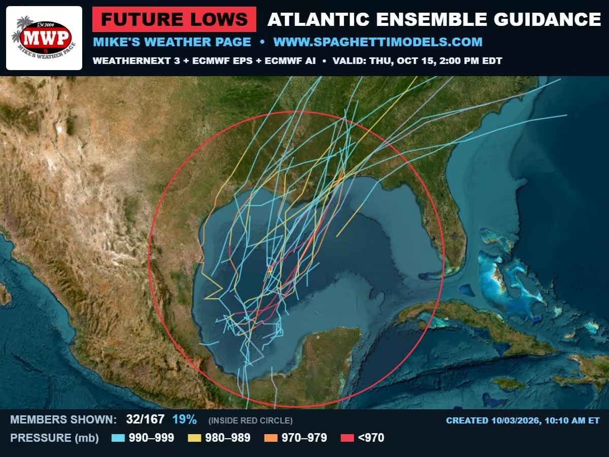 Mike's Weather Page
@tropicalupdate
Interesting weather pattern this next week or so. Looking at EPS on tropicaltidbits.com here. Low pressure lingers all week in the lower Gulf. Rain maps showing several days of extra chances as this pumps things NE. Definite sign of what El Nino does in the fall and winter. Tropical chances still remain very low. Few ensembles not giving up. But only a few. Not sure any rain forecast is solid right now. Chances are there. Weather or not things fall is a different story. www.spaghettimodels.com
 Mike's Weather Page
@tropicalupdate
Big blob coming. Not a named tropical system but will bring rains like one. Current Saturday AM satellite here. Moving north. Flood watches up for parts of the red circled area. Heavy rain expected today and tomorrow there. www.spaghettimodels.com
 Mike's Weather Page
@tropicalupdate
Saturday morning NHC Tropical Outlook. ZIPPO! Nothing cooking. No areas highlighted to watch. And Fay is finally gone. Enjoy! www.spaghettimodels.com
 Mike's Weather Page
@tropicalupdate
Decorating for Fall. Great new cans @BuschBeer I love them. Makes me feel gooooooooood. Loving local dinner. Music. Cooler weather. And awesome food. Hope your nights going great. Mine is. I think lol.
 Mike's Weather Page
@tropicalupdate
Heavy rains expected for an extended period as a lingering front juices things up along the upper Gulf. This just posted showing things pushing farther down into Florida early week. Some isolated double digits showing for some. Might need an ark. www.spaghettimodels.com
 Mike's Weather Page
@tropicalupdate
Lots of buzz on brewing rains into next week for Florida and the southeast. This was just posted extending heavy rain chances even longer. Flooding possible in hatched areas. Interesting pattern to watch unfold. www.spaghettimodels.com
 Mike's Weather Page
@tropicalupdate
Friday radar entering the afternoon. More rain for the Keys... East coast... Panhandle. All getting some as things flow from the south. More expected to build inland later. West peninsula Naples northward still showing later juice. www.spaghettimodel.com
Mike's Weather Page
@tropicalupdate
The 24 hour daily rainfall totals for next week are pretty wild. Latest NOAA numbers here Monday through Thursday. Stalled front juicing things up for sure. Double digits for some expected. Signs of an El Nino Fall/Winter maybe. Weather it happens or not we will sea.
 Mike's Weather Page
@tropicalupdate
Chances less than yesterday when looking at 10 day ensembles from the EURO EPS/AI and WNV3. 15% of the ensembles showing 'something' below 1000mb. That is 85% chance of 'nothing'. Nothing official from the NHC on this discussion. Just some long-range modeling was teasing. All good for now! www.spaghettimodels.com
 Mike's Weather Page
@tropicalupdate
Friday's 10/02/26 "Daily Brew": x.com/i/broadcasts/1dxYlaAnqeZJX
Mike's Weather Page
@tropicalupdate
Current Friday AM radar. Solid line paralleling the west coast. Looks like it will drift east with afternoon chances up for many across the peninsula. West central areas (Tampa Bay) looking like some heavy stuff around 5/6/7. Will be watching progress through the day.
 Mike's Weather Page
@tropicalupdate
10/02 Walking and talking...
Mike's Weather Page
@tropicalupdate
Friday AM NHC Tropical Update. Old Fay hanging on with a 10% chance to come back (again and again). Turning N/NE. Likely missing Bermuda. That's it. Nothing else on the NHC radar. Some chatter on lower Gulf next week. But those chances seem lower today than yesterday. Will keep watching. Have a great Friday and weekend ahead! www.spaghettimodels.com
 Mike's Weather Page
@tropicalupdate
If you don't want anything to form in the tropics you want a lot of wind shear. So far this season there has been a lot. Typical of an El Nino year, which we are in. Some ensembles have been showing lower Gulf next week. Some. Not all. The EURO seems to have done well this year detecting areas of possible development vs. the AI models which have been pretty aggressive at times. The EURO does great with upper air patterns. These shear maps on tropicaltidbits.com show shear early next week. Lots of it middle/upper Gulf. Not saying zero chance. Just saying conditions not ideal for development if this shear exists. More sloppy east pushing rains could be the story. As I keep saying. No stress yet. No bets yet. Carry on! www.spaghettimodels.com
 Mike's Weather Page
@tropicalupdate
WOW! Some big numbers here... for some. Rainfall totals here from NOAA the next 7 days. Not all at once and likely will be spread out over several days. A lingering front with tropical juice from the south all working together. The Keys already say this yesterday.
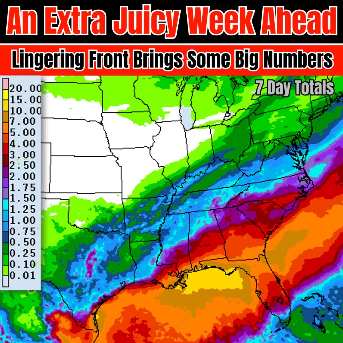
Mike's Weather Page reposted
 Gwen Filosa Media Key West
@GwenFilosaMedia
Sometimes it rains in Key West….hard.
KWPD: stay away from Front and Simonton streets and please no wakes — vehicles push water into businesses like @TattoosnScarsKW seen here
Mike's Weather Page
@tropicalupdate
Well. I got a second night out of it. But bumped into it the next day and more fell apart. Not sure it has many more left. Sniff. Sniff.
 Mike's Weather Page
@tropicalupdate
Thursday afternoon 12z ensembles. Showing members 1000mb and under. Little less than my morning post with 25% showing now. Watching lower Gulf next week. Nothing solid yet at all. No stress. www.spaghettimodels.com
 Mike's Weather Page
@tropicalupdate
Thursday 10/01/26 Tropical Update: Little signs maybe something in the Gulf next week. And lots of rain coming Florida. Here's the latest.
Mike's Weather Page
@tropicalupdate
Tropical feeling rains moving up through the Keys today. Big rains this afternoon dumped several inches causing some flooding. Read some businesses even put out some sand bags. Similar pattern tomorrow. These pictures from Sloppy Joes. I have had a few there before. Anyone else?
 Mike's Weather Page
@tropicalupdate
Latest on the Florida drought. Even with all this rain some areas still in a level 3/4 (red). www.spaghettimodels.com
 Mike's Weather Page
@tropicalupdate
Make up your mind Fay. You come and go, come and go. Back again this afternoon with 10% chance. Eventual turn off to the NE likely no matter what. No other areas highlighted to watch in the Atlantic. www.spaghettimodels.com
 Mike's Weather Page
@tropicalupdate
Latest Thursday ensembles on lower Gulf idea. Showing only low pressures under 1000mb from the EURO EPS / EURO AI / DeepMind WNV3. Roughly 29% show maybe something. Looks like a lingering front next week might leave behind a low pressure area. Sloppy rainmaker or more too soon to tell. Will look at the afternoon runs and compare later today. www.spaghettimodels.com
 Mike's Weather Page
@tropicalupdate
Holy cow. Stalled front showing across Florida next week. Could be some daily rains that really add up. Latest NOAA blend here shows totals through following weekend. Moist and Juicy for sure. www.spaghettimodels.com
 Mike's Weather Page
@tropicalupdate
Thursday's 10/01/26 "Daily Brew": x.com/i/broadcasts/1pKkOXvqLnjKj
Mike's Weather Page
@tropicalupdate
Latest overnight ensembles on weathernerds.org. Still keeping idea open on lower Gulf the second week of October. Not all the members agree, with the EURO showing the least. No worries yet. Just keeping up with the lastest. Low pressure showing regardless. Maybe sloppy from an old front, meaning just rains. Too far away to guess or make bets yet. www.spaghettimodels.com
 Mike's Weather Page
@tropicalupdate
Wet weekend for some along the upper Gulf. Lingering front. Gulf juice pulling north. All combining for higher rain chances. Saturday and Sunday excessive rainfall outlooks here. www.spaghettimodels.com
 Mike's Weather Page
@tropicalupdate
Thursday precipitable water map. It shows juice in the air. Red/Purple usually means rain. Or at least higher chances. #1: Leftover Pacific Polo mingling with frontal line. Heavy rains and flooding expected. #2: All this sliding north. Not tropical. Just extra rains. Some storms. Will reach upper Gulf tomorrow and mingle with that same front. #3: Hurricane Rachel in the Pacific. Going west. www.spaghettimodels.com
 Mike's Weather Page
@tropicalupdate
Thursday morning radar. Keys and south Florida juicy once again. East coast too. Flow generally south to north today. Tomorrow AM similar. www.spaghettimodels.com
 Mike's Weather Page
@tropicalupdate
Hanna gone. Fay gone. Nothing else is cooking out there in the Atlantic. Pacific staying hot. Long-range looking no more no less than yesterday on lower Gulf idea for October. No worries. www.spaghettimodels.com
 Mike's Weather Page
@tropicalupdate
9/30 Walking and talking... Forgot to post this AM lol. Cheers.
Mike's Weather Page
@tropicalupdate
Long-range looking. Frontal line lingering upping some heavy rain discussion. Kinda signs of a wetter El Nino Fall and Winter coming too. www.spaghettimodels.com
 Mike's Weather Page
@tropicalupdate
Nothing officially cooking in the Gulf. Long range models are picking up the maybe some idea. Put this together using EPS/AI/DeepMind ensembles under 1000mb. About 23% showing 'something'. Timing around the second week of October. Nothing to stress about right now that is for sure. Just showing. www.spaghettimodels.com
 Mike's Weather Page
@tropicalupdate
Rainfall totals the next 5 days. Pacific Hurricane Polo leftovers heading up into Texas and beyond. Gulf juice building and moves up through Florida and towards the upper Gulf. Frontal line helping lift all this for a large part of eastern US. www.spaghettimodels.com
 Mike's Weather Page
@tropicalupdate
Watching tropics the second week of October. Maybe. Signals increasing could see some low pressure developing. Named or not too far to know. Latest EPS EURO ensembles on tropicaltidbits.com teasing idea. Nothing on main operational noteworthy. Yet.
Few things contributing:
1: Old front arrives days before and lingers
2: Some Pacific juice looking to cross and pull into
3: CAG / Central American Gyre this time of year
4: Historically for October & during El Nino (and MJO)
 Mike's Weather Page
@tropicalupdate
Wednesday's 09/30/26 "Daily Brew": x.com/i/broadcasts/1AJEmvzXQpvJL
Mike's Weather Page
@tropicalupdate
Latest Wednesday AM ensembles from the EURO/Google here on weathermodels.com. Showing the Gulf. Not all of the members. Some yes. Enough to keep a watch on the idea. Timing second week of October. No bets yet. www.spaghettimodels.com
 Mike's Weather Page
@tropicalupdate
Overnight EURO ensemble blend with a little more percentage than yesterdays runs. Idea sticks. Historically a spot to watch this time of year, especially during El Nino. Nothing solid. But watching yes. Timing second week of October. www.spaghettimodels.com
 Mike's Weather Page
@tropicalupdate
Watching tropics... maybe. New Tropics map just released keeping the lower Gulf as a maybe the first half of October. Ensembles showing little more on idea too. Juice from Pacific mingling with old front likely if anything. No worries right now. Just keeping one eye on idea.
 Mike's Weather Page
@tropicalupdate
Hurricane Polo in the Pacific is bringing leftovers to the USA. Flooding maps showing big chances for some flooding rains today and tomorrow here. Texas and Oklahoma with tropical impacts. Wild. www.spaghettimodels.com
 Mike's Weather Page
@tropicalupdate
An incredible story from Dunedin, Florida. Storm Surge from Hurricane Helene took away a Memorial bench from the Dunedin Causeway back in 2024. It was recently found in Bermuda, which is over 1100+ miles away, likely due to the strong currents of the Gulf Stream. The bench honored Medhat 'Mike' Sadiku and the family was notified from the lady that found it. Just amazing!!! Read more: baynews9.com/fl/tampa/news/2026/09/28/memorial-bench-swep…
 Mike's Weather Page
@tropicalupdate
Gulf bubbling some rain and storms this Tuesday afternoon. Nothing tropical brewing out if this. Just pushing some rains up and east. www.spaghettimodels.com
 Mike's Weather Page
@tropicalupdate
Hurricane Polo bringing big rains to Texas and beyond. Flooding likely in many spots from all of this. Rainfall totals here the next seven days. Isolated areas could bring more. Some extra totals from incoming front and Gulf adding numbers to others. All around a wet eastern US for sure. www.spaghettimodels.com
 Mike's Weather Page
@tropicalupdate
Great to get to chat with @foxweather and @BobVanDillen about my Storm Chase in New Jersey on last weekend's Nor'easter.
Mike's Weather Page
@tropicalupdate
More Pacific action with newly formed Tropical Storm Rachel. Some of the models a week+ ago showed some crossover action to maybe watch. But as we can see models aren't showing those chances currently. Likely curving back west. www.spaghettimodels.com
 Mike's Weather Page
@tropicalupdate
Thanks to @livenowfox for having me on to talk about this weekends Nor'easter. I was live 'in it' literally from Highlands, NJ.
Mike's Weather Page
@tropicalupdate
Tuesday's 09/29/26 "Daily Brew": x.com/i/broadcasts/1PKqrNdXMebGb
Mike's Weather Page
@tropicalupdate
Early October signals still coming and going for that lower Gulf idea. Latest EURO ensemble blend with a little more percentages this AM. Will keep an eye on trends. MJO might be adding a little boost. Nothing solid at all to get stressed about. Just an area you might be hearing about as a big maybe. www.spaghettimodels.com
 Mike's Weather Page
@tropicalupdate
Tuesday AM Tropical Update. Fay is back as a Tropical Storm. Make up your find geeeeesh. Still expected to fizzle anyday. Hanna is heading off east. Nothing else on the NHC radar. No stress out there as we near October. www.spaghettimodels.com
 Mike's Weather Page
@tropicalupdate
Through the eyes of Mike: Chasing a Jersey Shore Nor'easter. See the journey from start to finish, with daily documentation as things progressed. Here inside thoughts. See things live as they happen. All from a unique real-time point of view. A little different style from past MWP storm chases.
Mike's Weather Page
@tropicalupdate
Signs of El Nino continue. Usually a wetter (and stormy) fall and winter is on tap for the southeast in this pattern. Long-range modeling has been signaling. Latest Oct/Nov/Dec outlook here agrees. We will sea. But odds say yes. www.spaghettimodels.com
 Mike's Weather Page
@tropicalupdate
Got some extra juice coming early October for the southeast. And it looks to linger through the month (some). Timeframe here the first week. Gulf juice pumping up from the south mingling with a slow moving frontal line. Signs of an El Nino Fall/Winter sneaking in.
 Mike's Weather Page
@tropicalupdate
Welcome Hanna. We now have a new Tropical Storm in the Atlantic. NHC cone here has it eastbound and down. Expected to peak at 45mph. Another name down. No hurricane 'Party in the USA' with this one. www.spaghettimodels.com
 Mike's Weather Page
@tropicalupdate
My scenes from this weekends Nor'easter along the Jersey Shore. Lots of Storm Surge in these clips.
Mike's Weather Page
@tropicalupdate
Monday's 09/28/26 "Daily Brew": x.com/i/broadcasts/1nxnRBNLDgjxO
Mike's Weather Page
@tropicalupdate
9/28 Walking and talking...
Mike's Weather Page
@tropicalupdate
Texas and Oklahoma likely dealing with leftover Hurricane Polo from the Pacific. Rain map here shows the flow this week up from the south. Lots of flood advisories already posted anticipating. www.spaghettimodels.com
 Mike's Weather Page
@tropicalupdate
Monday AM Tropical Update. Fay expected to fizzle again. Make up your mind. No worries there. Invest 91 in the middle Atlantic up to red 80%. Next name Hanna. Not going to Montana. Nothing else cooking solid on the models. Pacific continues to be the hot spot this year.
 Mike's Weather Page
@tropicalupdate
This tease of cooler air might have been 'false fall', at least for some. Long-range temps showing back to warm early October for the southeast and Florida. Not seeing any big cool fronts on the horizon. www.spaghettimodels.com
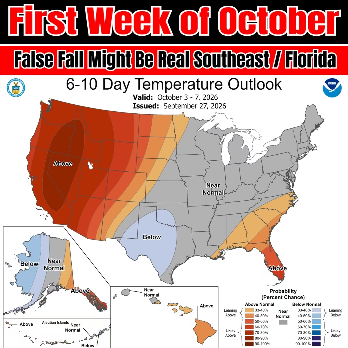 Mike's Weather Page
@tropicalupdate
Oh BTW. Invest 91 is up to orange in the middle Atlantic. Going eastbound and down. Next...
 Mike's Weather Page
@tropicalupdate
Storm Surge! Chased the Nor'easter Sunday morning back to Highlands, NJ. Tracked the low watching the winds and tides. Figured this would be the spot for maximum rise. It sure was. Locals said it was the highest there since Sandy. Including some that have lived their whole lives there. Business owners confirmed. It's amazing to me how fast surge comes in. From nothing to something. What an eventful trip for sure. Met a ton of great people. And really enjoyed the scenery of the Jersey Shore. Until next time...
Mike's Weather Page
@tropicalupdate
Made a pitstop. Yummy! Any guesses?
 Mike's Weather Page
@tropicalupdate
 Mike's Weather Page
@tropicalupdate
It was a chilly Sunday morning across Florida... for some. 50s made it deep into the state. Fall sneaking in for sure. You like?
 Mike's Weather Page
@tropicalupdate
Sunday late morning satellite of our early season Nor'easter. Not technically an eye... but... I'm under it. Making it ashore the Jersey Shore.
 Mike's Weather Page
@tropicalupdate
Watching the Storm Surge race in this AM in Highlands, NJ.
Mike's Weather Page
@tropicalupdate
Storm surge this Sunday AM in Highlands, NJ. More than some expected. The low passing to the south with combined N/NE winds along with a full moon adding the push. Amazing how fast it comes in.
Mike's Weather Page
@tropicalupdate
Watching this Nor'easter spinning in Sunday morning. More surge expected. Heading in.
Mike's Weather Page
@tropicalupdate
Sunday AM tropical update. Old Fay barely hanging on. New orange NHC spot pointing east in the middle Atlantic. That's it. www.spaghettimodels.com
 Mike's Weather Page
@tropicalupdate
Watched some fast incoming storm surge last night in Highlands, NJ.
Mike's Weather Page
@tropicalupdate
Our Nor'easter is slowly approaching the NJ coast this Sunday AM. Current winds showing the low level winds and spin. www.spaghettimodels.com
 Mike's Weather Page
@tropicalupdate
Storm Surge from inside Highlands, NJ tonight. Fascinating to see it in real-time. Video here talking about it before, then during, as it was happening. Comes in fast! Another round in the AM.
Mike's Weather Page
@tropicalupdate
Watching the tide roll in tonight here at Atlantic Highlands, NJ. Breaking over the seawall. Big flooding here last night. Tonight expected to be a little less.
Mike's Weather Page
@tropicalupdate
Highlands, NJ
Mike's Weather Page
@tropicalupdate
Watching the Storm Surge race in tonight here in Atlantic Highlands.
Mike's Weather Page
@tropicalupdate
Highlands, NJ
Mike's Weather Page
@tropicalupdate
LIVE New Jersey Storm Chasing! x.com/i/broadcasts/1pKdRDORVEgJW
Mike's Weather Page
@tropicalupdate
Latest EURO/GFS for tomorrow Sunday AM on tropicaltidbits.com. showing lots of moisture. And decent chance of winds if that core stays tight on approach. Interesting to watch yes.
 Mike's Weather Page
@tropicalupdate
LIVE New Jersey Storm Chasing! x.com/i/broadcasts/1nxeLMOyqlLJX
Mike's Weather Page
@tropicalupdate
Behind the scenes action showing my live today with @foxweather. Ever wonder how I film. Here ya go lol!
Mike's Weather Page
@tropicalupdate
Skim boarding in the Jersey streets today...
Mike's Weather Page
@tropicalupdate
LIVE New Jersey Storm Chasing! x.com/i/broadcasts/1AJEmvQprngJL
Mike's Weather Page
@tropicalupdate
Dang! Look at that satellite. Saturday noon picture.
 Mike's Weather Page
@tropicalupdate
Had quite the adventure this AM around Surf City and Ship Bottom, NJ. Storm Surge came in fast!
Mike's Weather Page
@tropicalupdate
Some clips from this AM around Surf City, NJ. Storm surge came in fast. We barely got out.
Mike's Weather Page
@tropicalupdate
LIVE New Jersey Storm Chasing! x.com/i/broadcasts/1AGRnZEvlvZGl
Mike's Weather Page
@tropicalupdate
Big time flooding in Surf City, NJ this AM.
Mike's Weather Page
@tropicalupdate
Major flooding this AM in Surf City, NJ.
Mike's Weather Page
@tropicalupdate
Hey you!
 Mike's Weather Page
@tropicalupdate
Morning from Seaside Heights. Oceans angry!
Mike's Weather Page
@tropicalupdate
Made it to New Jersey. Pretty windy out here... and wet. High tide in the AM. Will see what we sea. Found a little local joint woohooooo. Cheers!
Mike's Weather Page
@tropicalupdate
Latest on Hurricane Nolo near Hawaii. Heavy rains the big impact there as storm passes below. www.spaghettimodels.com
 Mike's Weather Page
@tropicalupdate
Friday PM update on Polo. Currently 180mph! Eventually bringing rains to the US. www.spaghettimodels.com
 Mike's Weather Page
@tropicalupdate
Major Coastal Flooding upgrade today for a large area. Low pressure bending towards the east coast this weekend upping impacts for many. www.spaghettimodels.com
 Mike's Weather Page
@tropicalupdate
Guess where I'm heading...

Mike's Weather Page reposted
 NWS Weather Prediction Center
@NWSWPC
An intense nor’easter will bring dangerous coastal flooding, strong winds, and heavy rainfall to the Mid-Atlantic and Northeast this weekend, and the expected severity of impacts has increased. Check our latest key messages and visit weather.gov to stay updated.
Mike's Weather Page
@tropicalupdate
Friday afternoon look at our east coast low pressure taking shape. Got spinnage!
Mike's Weather Page
@tropicalupdate
The boys are ready. Are you? Cool air is making it's way into the state. Expect a cooler weekend in the AM hours for sure.
 Mike's Weather Page
@tropicalupdate
Latest Friday AM EURO ensembles showing northeast low pressure tracks. Bend towards the coast due to blocking high. Mean averages are close. Eventually weakens and turns back NE. Widespread impacts through the weekend. www.spaghettimodels.com
 Mike's Weather Page
@tropicalupdate
For those around Tampa Bay free preparedness event happening this Saturday, September 26 at the Tampa Central City YMCA from 10am-1pm: hurricane preparedness, hands-on safety workshops, resources, and giveaways. TECO will have its electrical safety demonstration truck there, along with the Red Cross, Tampa Fire, and other local organizations. Activities for the kids too, including learning how to call 911. A chance to bring the family out and learn a few things before the next emergency. Free and open to everyone, stop by anytime! I am planning to attend (if don't head to the Nor'easter).

Mike's Weather Page reposted
NCDOT NC12
@NCDOT_NC12
Pics from Pea Island this morning. The road is currently covered in 4' of water in some areas, as well as deep sand. At this point, it is impossible to assess the extent of any road damage, but once we do, we will have a better idea of repair/reopening options.


 Mike's Weather Page
@tropicalupdate
Friday's 09/25/26 "Daily Brew": x.com/i/broadcasts/1DGleVWnpmkJL
Mike's Weather Page
@tropicalupdate
Latest models on this weekends low pressure for the NE on tropicaltidbits.com. Hovering around 990mb with continued slow movement skirting coastal areas. Far reaching impacts likely ongoing. Winds in knots.
 Mike's Weather Page
@tropicalupdate
Friday AM update on Hurricane Nolo in the Pacific. Parts of Hawaii are under Watches and Warnings. Heavy rain expected with feet expected in spots. www.spaghettimodels.com
 Mike's Weather Page
@tropicalupdate
BTW. We now have Gonzalo in the far far Atlantic. Going to stay over there. Carry on. www.spaghettimodels.com
 Mike's Weather Page
@tropicalupdate
Did you step outside yet? Holy cow the cool air is here. Current Friday temps showing 60s deep into the state. More over the weekend! Brrrrrrrrrrrrrr.
 Mike's Weather Page
@tropicalupdate
Think I can get one more season out of it? Started out looking a little better the other night lol.
 Mike's Weather Page
@tropicalupdate
Invest 90. In case you were curious. Staying way way over there. Yawn. www.spaghettimodels.com
 Mike's Weather Page
@tropicalupdate
Red means high water. Current locations showing locations expected above HAT - Highest Astronomical Tides. www.spaghettimodels.com
 Mike's Weather Page
@tropicalupdate
Latest 12z HRRR longer range look at Saturday AM here on tropicaltidbits.com. Aggressive 983mb pressure with some big winds showing around 'center'. Future IR satellite shows the look from above of a classic opened Nor'easter or even subtropical system. Coastal impacts likely the biggest thing to watch.

 Mike's Weather Page
@tropicalupdate
Thursday AM NHC Key Messages on Nolo for Hawaii. Hurricane Watch remains for the Big Island. Huge rain totals expected. Feet of rain! Busy year over there for sure! www.spaghettimodels.com
 Mike's Weather Page
@tropicalupdate
9/24 Walking and talking...
Mike's Weather Page
@tropicalupdate
Are you ready? First real cool front of the season coming to Florida this weekend. Sunday Dew Points here showing in the 40s and 50s all way through the state. That makes the air feel fresh, cool, and dry. I might give in and get a pumpkin spice with the girls.
 Mike's Weather Page
@tropicalupdate
Thursday's 09/24/26 "Daily Brew": x.com/i/broadcasts/1qxvveXWOekxB
Mike's Weather Page
@tropicalupdate
Cold front pushing south. And pushing away those rain chances. Rainfall totals here through Sunday PM. Fall is in the air with low humidity and dew points. 50s into Florida this weekend with 60s dipping far far south. Yes they are morning lows haha. It will still be in the 80s. But 85 might feel like 79! www.spaghettimodels.com
 Mike's Weather Page
@tropicalupdate
The Outer Banks NC12 is closed on northern ends due to strong winds/waves and high tides. Ocean overwash seen on traffic cams here at Pea Island (top). Other efforts to keep things dry (bottom). www.spaghettimodels.com
 Mike's Weather Page
@tropicalupdate
Thursday morning look at the tropics. Fay hanging on for round two. Will fizzle in the open Atlantic. Africa spot Invest 90 up to 70%. Will stay in that general area. Next name Gonzalo. Nothing else cooking down the road to stress about. www.spaghettimodels.com
 Mike's Weather Page
@tropicalupdate
Some huge numbers possible coming to Hawaii from approaching Nolo. Feet of rain! www.spaghettimodels.com
 Mike's Weather Page
@tropicalupdate
Hurricane Polo back to CAT5 tonight in the Pacific. Eventual turn towards Baja California showing possible. Remnants might bring more juice north into the US early next week. www.spaghettimodels.com
 Mike's Weather Page
@tropicalupdate
Latest Wednesday PM look at expected Hurricane Nolo. Impacts for Hawaii likely. Tracks and cone shifting a little more to the south. A direct hit seems unlikely at this point. The Big Island is under a Hurricane Watch. www.spaghettimodels.com
 Mike's Weather Page
@tropicalupdate
Ran across this awesome BBQ spot here in Oldsmar. Scrolling the internet one night I saw a review and didn't even know it was so close. Cool vibe. Great sides. Amazing meat. Give them a try! Southern BBQ (behind Thorntons on Tampa Rd). #supportlocal
 Mike's Weather Page
@tropicalupdate
A Hurricane Watch is now posted for Hawaii. Tropical Storm Nolo is expected to be a Major with most tracks passing 'center' close to the south of Big Island. Impacts likely, including heavy rains. www.spaghettimodels.com
 Mike's Weather Page
@tropicalupdate
Interesting to see the Nor'easter this weekend helping spin down cooler dry air through Florida. Weekend water vapor here shows general idea how. Dry air is the brown. Taste of fall for sure on the way. I am getting wood. For my firepit. www.spaghettimodels.com
 Mike's Weather Page
@tropicalupdate
Wednesday afternoon EURO and EURO AI models inching closer to the NE coast this weekend. Latest here on tropicaltidbits.com. Coastal impacts likely. Some heavy rain. And winds matching a strong Tropical Storm or even Hurricane with pressures around 990mb showing. Full moon adding to the water rise. www.spaghettimodels.com
 Mike's Weather Page
@tropicalupdate
Make up your mind up Fay. Now back to 70% chance. It fizzled yesterday into nothing. Current look here. www.spaghettimodels.com
 Mike's Weather Page
@tropicalupdate
Tropical Update. New Tropics map posted from NOAA. Highlighting lower Gulf as a low chance for something maybe tropical popping early October. Kinda the same idea teased a bunch last week. Models still not showing too much but idea remains. EURO ensembles on bottom with general area for same timeframe. No worries right now. www.spaghettimodels.com
 Mike's Weather Page
@tropicalupdate
BREAKING NEWS! Kinda haha. NWS lowering morning lows for this weekend Florida. Sunday AM now showing 50's dipping deep with 60's making it way way way south. Saturday similar. That Nor'easter is helping spin in some of this cooler attic air. Firepit weather for sure. Now I have a serious question. Does Publix have wood yet? I need some.
 Mike's Weather Page
@tropicalupdate
Wednesday's 09/23/26 "Daily Brew": x.com/i/broadcasts/1AKEmvRgPOAKL
Mike's Weather Page
@tropicalupdate
Wednesday AM tropical update. Far Atlantic spot up to orange 40%. Odd track but likely stays over there. Fay is gone. Some remnants might come back and hang in the middle Atlantic. NHC at 20% for that. Nothing else cooking out there. www.spaghettimodels.com
 Mike's Weather Page
@tropicalupdate
Hawaii dealing with another one. Hurricane expected as it nears the Big Island in a couple days. Heavy rain regardless of track. www.spaghettimodels.com
 Mike's Weather Page
@tropicalupdate
Got to talk tropics at the top of the hour with Fox @livenowfox. So fun. Thank you so so much! And they used my new MWP graphics woohoooooooo!!!
 Mike's Weather Page
@tropicalupdate
Tuesday 9/22/26 Tropical Update: CAT5 Hurricane Polo in the Pacific. The latest on the Atlantic. This week's Nor'easter. A Florida cold front. Hawaii watching tropics again. Here's the latest weather in a nutshell.
Mike's Weather Page
@tropicalupdate
Hawaii watching the tropics once again. Some big rains on radar already from the remnants of TD15. Latest Key Messages here. www.spaghettimodels.com
 Mike's Weather Page
@tropicalupdate
Hurricane Polo even stronger Tuesday afternoon. Now up to 180 mph! Pressure 892mb. One of the strongest on record. Latest look here. www.spaghettimodels.com
 Mike's Weather Page
@tropicalupdate
Polo in the Pacific has rapidly intensified to 165mph. A powerful CAT 5 moving NW just off the coast of Mexico. Current Tuesday satellite. www.spaghettimodels.com
 Mike's Weather Page
@tropicalupdate
Some max wave numbers through Friday PM. Atlantic will be rocking and rolling, all the way to Florida. Deepening low. Cold front. All helping. Weekend remains in play as low lingers off the Mid-Atlantic. www.spaghettimodels.com
 Mike's Weather Page
@tropicalupdate
Happy first day of Fall. This is how we roll here in Florida. The only fall colors we see is on the ground from fallen palm fronds.
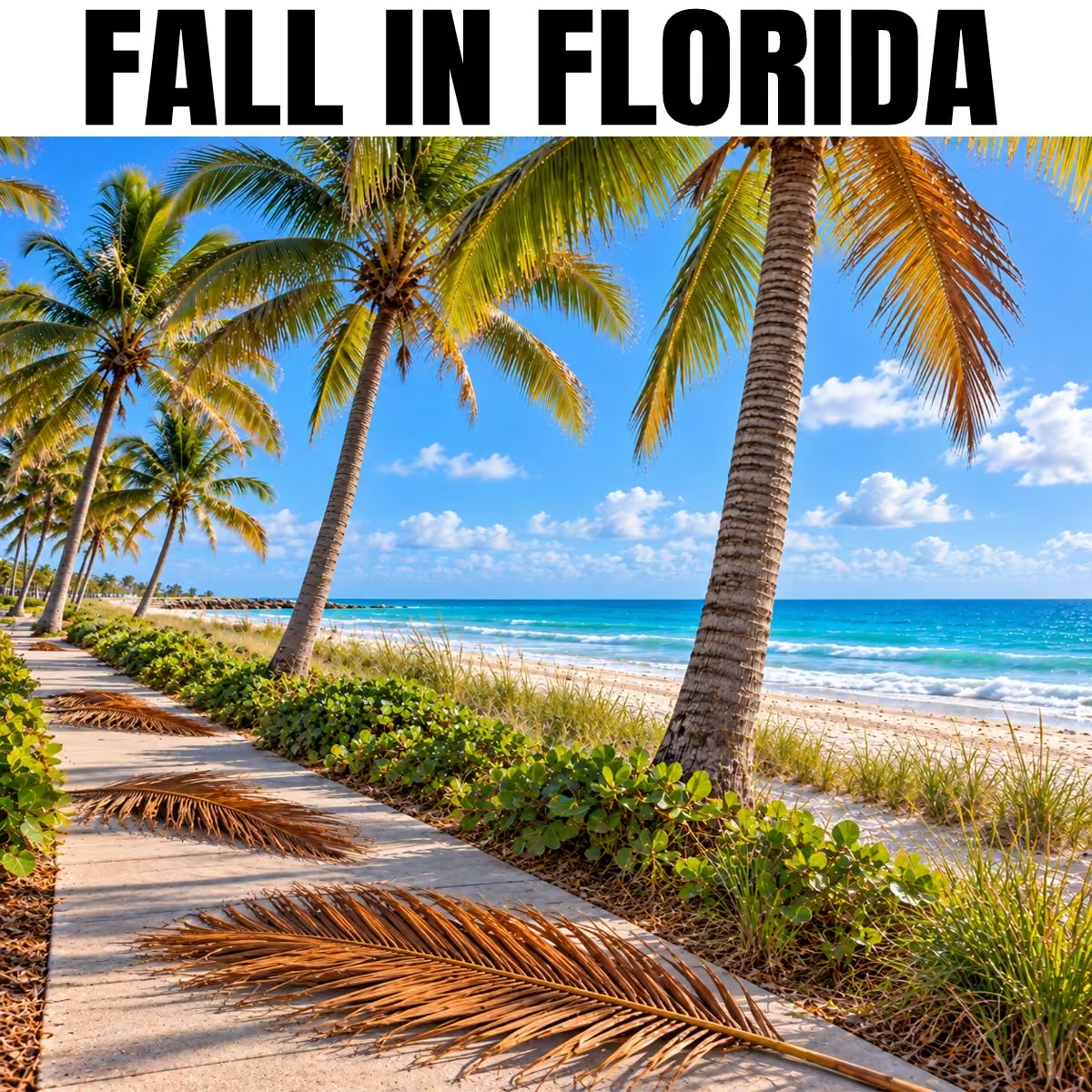 Mike's Weather Page
@tropicalupdate
Tuesday's 09/22/26 "Daily Brew": x.com/i/broadcasts/1DxLdZaagAvxm
Mike's Weather Page
@tropicalupdate
Florida rainfall today Tuesday. Coverage map here paints idea what areas get the most. Farther south you go the better the chances. Mixed movement today with these. www.spaghettimodels.com
 Mike's Weather Page
@tropicalupdate
Tuesday AM NHC tropical update. Tropical Storm Fay barely hanging on. Fizzling soon. Newer area off Africa going to stay over there. Nothing else showing. The record streak of no Hurricanes continues. October sneaking in fast! www.spaghettimodels.com
 Mike's Weather Page
@tropicalupdate
Deepening coastal low fixing to brew. Latest EURO here on tropicaltidbits.com showing sub-990mb trends continue. High pressure slowing movement, blocking, turning close to the coast this weekend. OBX starts feeling tomorrow with winds/waves from the NE.
 Mike's Weather Page
@tropicalupdate
Guess what Florida! An actual cold front is coming this weekend. NWS low temps here for Sunday AM showing 60's deep into the state. Low humidity and dew points will make many feel some cooler air most the weekend. Need to get some wood for that firepit! www.spaghettimodels.com
 Mike's Weather Page
@tropicalupdate
Florida cold front this weekend. Yes it is true. Look!
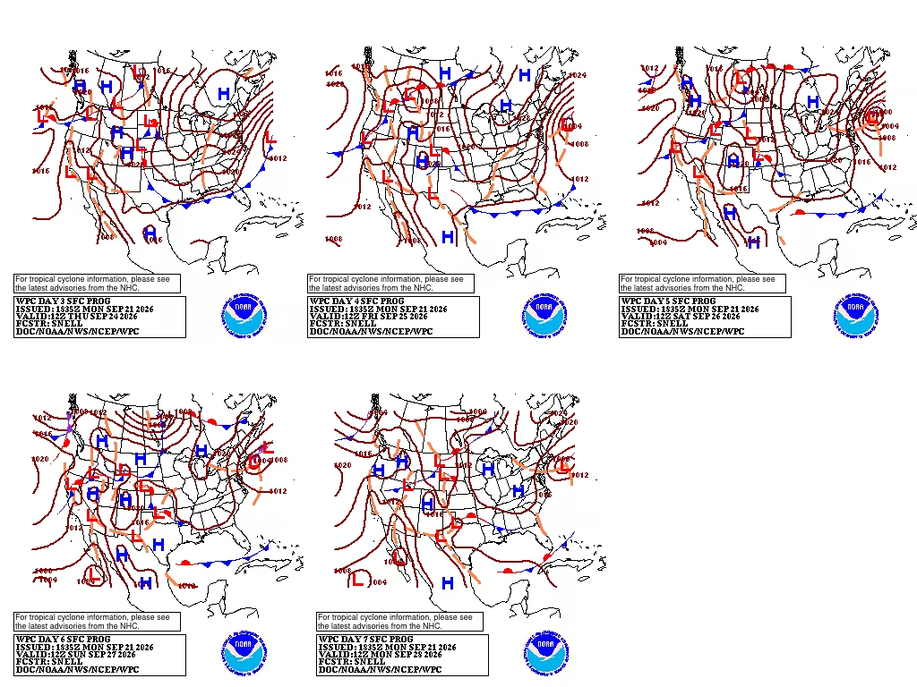 Mike's Weather Page
@tropicalupdate
One of the largest US flags in Florida here at OCC in Pinellas Park. Full moon coming this weekend. Might add to the impacts for the east coast low pressure brewing. www.spaghettimodels.com
 Mike's Weather Page
@tropicalupdate
Had to edit. Used to be.
Mike's Weather Page
@tropicalupdate
Awesome sunset tonight here in Clearwater. Julie sent this to me just now.
 Mike's Weather Page
@tropicalupdate
Latest Key Messages on coastal low pressure setting up along the east coast. www.spaghettimodels.com
 Mike's Weather Page
@tropicalupdate
Deepening coastal low skirts the east coast this week. Wednesday into Thursday could get extra windy for the Outer Banks (northward). Latest EURO deepens under 990mb this weekend just off the NE coast (south of Cape Cod). www.spaghettimodels.com
 Mike's Weather Page
@tropicalupdate
The naked swirl. Lower clouds are yellow (no rain). Upper clouds are white (rain/storms). A sign of strong wind shear and a storm falling apart. Monday afternoon satellite here of Tropical Storm Fay. Won't last long like this. www.spaghettimodels.com
Mike's Weather Page
@tropicalupdate
New NHC spot marked this Monday afternoon coming off Africa. Models keeping it close to Africa and not heading much west. Chances 20%. www.spaghettimodels.com
 Mike's Weather Page
@tropicalupdate
A juicy south Florida this AM thanks to upper low flow in from the Gulf. This pivots later in the afternoon with rains/storms flowing in from the east. Should be a classic view of storms later this evening reaching the central west coast. Timing here around 6/7pm.
 Mike's Weather Page
@tropicalupdate
East coast low pressure the weather this week to watch. Blocking high pressures still showing this weekend stalling a fast exit out to sea. Midweek OBX north will start feeling coastal impacts. EURO dipping under 990mb just off the coast. Warm waters combining with upper front will support a mix of fuel for rains/storms.
 Mike's Weather Page
@tropicalupdate
Current Monday look at upper winds. El Nino brings a lot of shear to the Caribbean which helps prevent storms, as seen here. Also that upper low pressure still showing over Florida. This is controlling rain flow again today. Heavy south Florida. Building east to west later in the day. www.spaghettimodels.com
 Mike's Weather Page
@tropicalupdate
Monday's 09/21/26 "Daily Brew": x.com/i/broadcasts/1aKbdEpwMwBJX
Mike's Weather Page
@tropicalupdate
The latest on Fay. Starting to weaken with shear taking over. The no hurricane streak continues. Hanging out in the middle Atlantic. No US impacts (or Bermuda). www.spaghettimodels.com
 Mike's Weather Page
@tropicalupdate
9/21 Walking and talking...
Mike's Weather Page
@tropicalupdate
More Pacific action heading up towards the US. New Mexico with some heavy rain coming thanks to Tropical Storm Polo. www.spaghettimodels.com
 Mike's Weather Page
@tropicalupdate
Heavy rains this week showing. South Florida from a lingering frontal line. Northeast later week from coastal low. This could bring some impacts the closer it gets to the coast. www.spaghettimodels.com
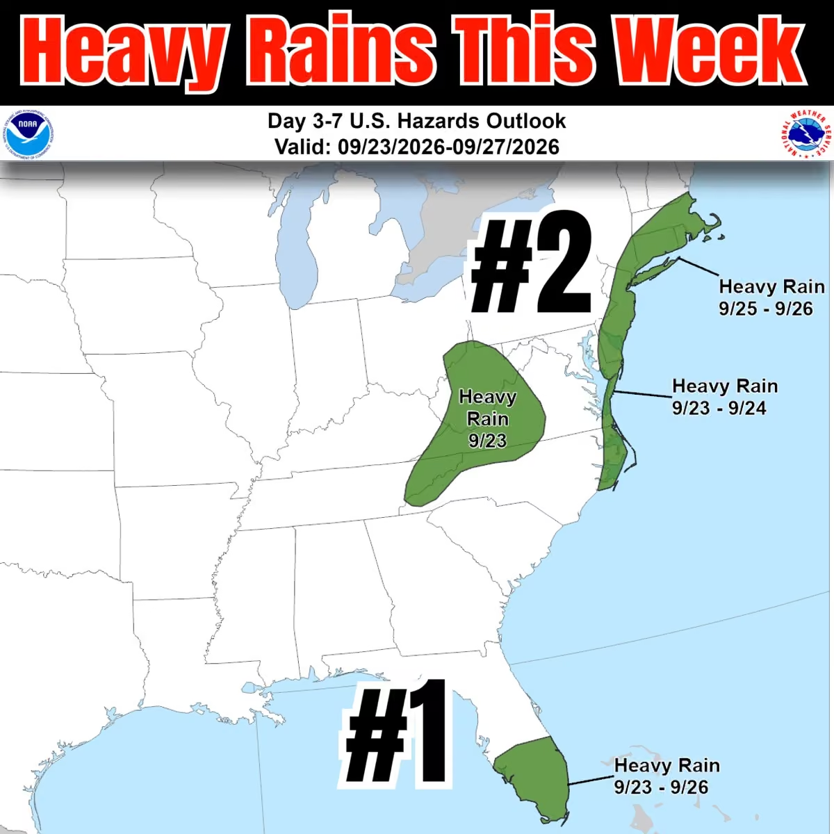 Mike's Weather Page
@tropicalupdate
I've missed you buddy. First firepit of the season. Riley Green playing now and sipping on some Jim. Heck yea!
 Mike's Weather Page
@tropicalupdate
Wild looking satellite this Sunday afternoon and evening over Florida. Mid-level spinnage for sure showing. Not tropical. But helped boost some rains and storms across the state today. www.spaghettimodels.com
Mike's Weather Page
@tropicalupdate
Bucs fans. Well. Not the most exciting first couple weeks. Not seeing much to be pumped about. Continuation of last years ending for sure. Boooooo.
Mike's Weather Page
@tropicalupdate
Let's go Bucs!
 Mike's Weather Page
@tropicalupdate
Watching end of week low pressure getting close to the east coast. Some latest models here on tropicaltidbits.com in the 980/990mb range. Heavy rains, coastal waves and winds likely for a big chunk. Not marked from the NHC. Could be more of a Nor'easter type setup with front coming in. www.spaghettimodels.com
 Mike's Weather Page
@tropicalupdate
A look at the Pacific, in case you were interested. Staying busy. www.spaghettimodels.com
 Mike's Weather Page
@tropicalupdate
Long and skinny SPC area today. Hmmm.
 Mike's Weather Page
@tropicalupdate
Tracking the tropics. And low pressures. The crossover idea, lower Gulf, lost a lot of support the past few days. The main area this week to watch is low pressure off the east coast moving northward. Some turn close enough to cause some impacts. Winds/waves/rains. Tropical maybe not. Nor'easter kinda maybe. Who knows. But most runs keep showing a lowering sub-1000mb pressure turning close end of week. www.spaghettimodels.com
 Mike's Weather Page
@tropicalupdate
Rainfall totals this week. Few areas with big numbers. Invest 99 from the Pacific heading north into southwest US. Low pressure something something hugging the east coast maybe bending close to cause some impacts. South Florida frontal line stalls upping several days of extra rains. www.spaghettimodels.com
 Mike's Weather Page
@tropicalupdate
BREAKING NEWS! Well kinda. We have Fay. Staying in the middle Atlantic. No US impacts. Carry on. www.spaghettimodels.com
 Mike's Weather Page
@tropicalupdate
Bristol baby! Rock you like a hurricane!!
 Mike's Weather Page
@tropicalupdate
Sarah looking absolutely beautiful tonight for her Senior High School Homecoming. And it was magic. The rain stopped and a rainbow came out just in time for pictures. We can't believe this day is here. Thoughts keep going back to the day she was born. The fear. The unknowns. The wonder what her journey would be like. Well it couldn't have been better. So many wonderful memories. So much love. From not only friends and family, but everyone we have met along the way. I know our moms are smiling from above. And I know they made this special day possible for our little girl. We love you Sarah!!!
 Mike's Weather Page
@tropicalupdate
I'm kinda sad. I love summer. Look forward to summer. Now this is the last summer weekend of the year. Fall is next week. Anyone else?
 Mike's Weather Page
@tropicalupdate
Saturday 9/19/26 Tropical Update: Tropical Depression 6 now in the Atlantic. Some Florida news. East coast brewing maybe something something. Here's what's cooking.
Mike's Weather Page
@tropicalupdate
Some sort of low looks to skirt the east coast this week. Could bend close enough to the NE to bring some impacts later week into the weekend. Latest operational runs here from tropicaltidbits.com hints idea. Winds, waves, rains, storms might be all on the plate.
 Mike's Weather Page
@tropicalupdate
We now have Tropical Depression #6. Expected to reach Tropical Storm Fay then fizzle in the open Atlantic in a few days. Another name down. www.spaghettimodels.com
 Mike's Weather Page
@tropicalupdate
Looking at the Tropics. Area #1: The area I have been mentioning this week continues to lose chances. Models backing off even more for end of month low pressure to watch in the Gulf/Caribbean. Area #2: Some sort of low pressure continues to show on models end of week. Skirts the east coast. Might turn close to cause some impacts into the weekend. Nothing official but rains/winds/waves likely coming for the NE. And we now have TD#6 from Invest 99 in the far far Atlantic. No worries. www.spaghettimodels.com
 Mike's Weather Page
@tropicalupdate
Looking at rainfall. NOAA blend of models here showing basic idea of totals though Friday PM. Some isolated areas could get more but the juice is trending heavy for SFL. Atlantic watching for some sort of low to skirt close towards the end of the week. Some of that rain showing.
 Mike's Weather Page
@tropicalupdate
South Florida is in for an extra period of heavy rains. Excessive rain outlooks here the next four days show. And the long-range NOAA map shows heavy rains specifically for SFL 9/22-9/25. www.spaghettimodels.com

Mike's Weather Page reposted
 Podman
@4x6podman
@tropicalupdate
Call almost clear sky Morning glow from Titusville - view east across the Indians River toward space center -
Enjoy the beauty -

 Mike's Weather Page
@tropicalupdate
Satellite imagery this Saturday AM showing mid-level water vapor. Definite low pressure area inching westward. This will amplify isolated storms throughout Florida today. Widespread yes. But a little more pop in some. South Florida spinning in extra rains the next several days with the help from this flow. Heavy rain totals for some. Tropical development not expected from this in the Gulf. www.spaghettimodels.com
Mike's Weather Page
@tropicalupdate
Saturday AM NHC update. Only Invest 99 showing as areas to watch the next 7 days. Its chances have been bumped up to 90%. Might be another short lived tropical system this season. No US impacts. Next name is Fay. www.spaghettimodels.com
 Mike's Weather Page
@tropicalupdate
More Pacific action likely bringing southwest US impacts. Heavy rain showing on future rain maps next week from Invest 99. Latest look here. www.spaghettimodels.com
 Mike's Weather Page
@tropicalupdate
A northeast storm might be brewing later next week. A low pressure area has been showing up consistent coming up along the east coast. Will come down to a large blocking high. If that happens it could turn 'whatever' westward towards coastal areas. EPS Euro ensembles here on tropicaltidbits.com showing a possible reality. Nothing official. But an idea to keep an eye on.
 Mike's Weather Page
@tropicalupdate
Invest 99 up to 80% chance this Friday night. Currently over in the far Atlantic near the Azores. Happened quick as it wasn't marked until today. No impacts to the US. Turning SW then fizzle expected. Latest look here. Next name Fay. www.spaghettimodels.com
 Mike's Weather Page
@tropicalupdate
Friday afternoon / evening storms fixing to brew across GA/SC/NC. North Carolina showing biggest chances. www.spaghettimodels.com
 Mike's Weather Page
@tropicalupdate
Lots of juice out there across south Florida and the Bahamas the next several days. Models starting to tease idea on something in the Atlantic next week. Nothing from the NHC to watch yet. Just seeing some trends. Most move 'it' off NE. Could be something that pops up. We will sea. Rain regardless. Here are some latest totals through the week. www.spaghettimodels.com
 Mike's Weather Page
@tropicalupdate
That happened quick. Invest 99. Nothing overnight now 60% chance. Near the Azores. Might meander a little and track SW some. Got clear spinnage on satellite. Maybe Fay brewing. No US impact. www.spaghettimodels.com
 Mike's Weather Page
@tropicalupdate
Interesting weather pattern for Florida the next few days. Mid-level low pressure, not tropical, can be seen on satellite and radar today. Current look here. It is sliding west. Will spin rains in from the Gulf for the Keys and lower state while spinning in Atlantic rains for the east coast that head westward later Saturday/Sunday. So if your APP shows higher rain chances, this is why. Lots of rain for lower Florida lasts into next week. www.spaghettimodels.com
Mike's Weather Page
@tropicalupdate
Friday's 09/18/26 "Daily Brew": x.com/i/broadcasts/1qKVmyMwzWXxB
Mike's Weather Page
@tropicalupdate
9/18 Walking and talking...
Mike's Weather Page
@tropicalupdate
Do you feel it north Florida? 60s made it widespread throughout the area this AM. I even feel it some here in Tampa Bay walking. Pretty cool. Some of the lows this Friday morning here.
 Mike's Weather Page
@tropicalupdate
Friday AM look at the tropics. Invest 98 went POOF. Chances 0%. New spot near the Azores far far away. Chances there 30%. Enjoy the weekend tropics free! www.spaghettimodels.com
 Mike's Weather Page
@tropicalupdate
Friday AM update. Watching end of month tropic chances for the Caribbean and Gulf. Latest overnight ensembles backing off from the past few days. EURO top. DeepMind bottom. Main EURO keeps idea there some. AI changed its mind. We will sea. East coast of US showing a few still that move off NE. Bottom line. Zippo to stress about right now. Could put us through September if models continue to agree, and disagree. www.spaghettimodels.com
 Mike's Weather Page
@tropicalupdate
Great segment today with @foxweather and @BobVanDillen talking tropics, weather, looking ahead, and much much more. Check it out! www.foxweather.com/watch/fmc-9jtd3u7ryzc2e9bq
 Mike's Weather Page
@tropicalupdate
It's officially fall season in my books when mums hit the shelves at Lowe's. Got some just now. Now if I could just figure out how to keep them around until Halloween.
 Mike's Weather Page
@tropicalupdate
Tampa radar last night. They're here......
 Mike's Weather Page
@tropicalupdate
Thursday 9/17/26 Tropical Update: Invest 98 in the Atlantic. Maybe something brewing end of month. And a taste of Fall is in the air.
Mike's Weather Page
@tropicalupdate
Thursday's 09/17/26 "Daily Brew": x.com/i/broadcasts/1yxBePEyOarJN
Mike's Weather Page
@tropicalupdate
Chances bumped back some for Invest 98 in the Atlantic. Latest NHC discussion here and modeling showing a motion north eventually. Staying hundreds of miles east of Bermuda and turn NE likely if anything remains. No worries. Next name Fay. www.spaghettimodels.com
 Mike's Weather Page
@tropicalupdate
Dry air has entered Florida today (for 2/3rds). Afternoon humidity levels here showing 30s/40s/50s for a big chuck of the state. That brings blue skies. No rain. And drier feeling air. 88 feels like 85! Might not have to go through a couple shirts today working outside.
 Mike's Weather Page
@tropicalupdate
Change of season is in the air. NC/SC/GA with low 60s showing this AM in spots. Some 50s! Current 7am temps here. How does it feel? www.spaghettimodels.com
 Mike's Weather Page
@tropicalupdate
Checking in the tropics. Late September signals from historical pattern this time of year remain. Lowering pressures in and around central America. Latest ensembles here on weathernerds.org. EURO top. DeepMind bottom. Same mixed ideas. Some do. Some don't. Some crossover from the Pacific. Nothing solid to stress on today that is for sure. Will keep a watch on it. www.spaghettimodels.com
 Mike's Weather Page
@tropicalupdate
Who's getting wood Friday night? Firepit weather begins. Sprinkled 60s through northern Florida showing here Saturday AM from the NHC. Still hot during the day but hey it's a start! www.spaghettimodels.com
 Mike's Weather Page
@tropicalupdate
Invest 98 now in the Atlantic. Chances still remain low. Future motion likely N/NE from whatever it becomes. No worries. www.spaghettimodels.com
 Mike's Weather Page
@tropicalupdate
New NOAA Tropics Hazards Map posted. Showing some weak signals for areas in the Atlantic (under 20%). And nothing in the Caribbean and Gulf. Map heads into October. Things can change as always. El Nino helping keep things slow. www.spaghettimodels.com
 Mike's Weather Page
@tropicalupdate
Homecoming for Sarah is this week. Julie does so good picking out clothes for Spirit Week. Today was 'Generation Day'. They went with an older lady... and nailed it! Can't wait to show you her dress for Saturday night. Senior this year. Sniff Sniff......
 Mike's Weather Page
@tropicalupdate
Wednesday's 09/16/26 "Daily Brew": x.com/i/broadcasts/1nxnRBmbRXOxO
Mike's Weather Page
@tropicalupdate
Wednesday AM update on middle Atlantic spot. Juice went down. Chances staying down. Still 30%. Not much to look at with it today. Most had it go N/NE if it did try anything sneaky. Current satellite here. www.spaghettimodels.com
 Mike's Weather Page
@tropicalupdate
9/16 Walking and talking...
Mike's Weather Page
@tropicalupdate
Little windy out there today Wednesday in from the east. Bringing in some dry air some might feel. www.spaghettimodels.com
 Mike's Weather Page
@tropicalupdate
Drier skies and extra low humidity today Wednesday for many across the south and east. Florida split around I-4. Things staying moist and juicy southward. Pattern remains a few days. A little taste of fall for some yes. www.spaghettimodels.com
 Mike's Weather Page
@tropicalupdate
Weak signal still showing on overnight ensembles for end of month. Google top. EURO bottom. Central America lowering pressures. Pacific crossover? General area to watch during El Nino years. Nothing solid to stress. Just looking like I like to do. Nothing official as most won't show things past 10 days as things usually change. But pattern is staying so worth mentioning at least. NOAA long-range outlook came out yesterday and are not highlighting area BTW (Gulf). www.spaghettimodels.com
 Mike's Weather Page
@tropicalupdate
Tropics brewing out west. Odd placement of a Pacific side storm for sure. NHC marking Gulf of California moving northward. Flooding likely for parts of the southwest US. Latest outlook showing levels 3/4 here. www.spaghettimodels.com
 Mike's Weather Page
@tropicalupdate
Chances lowered tonight for the NHC spot middle Atlantic. Models have been trending a little more 'nothing', especially the EURO. Time marches on... www.spaghettimodels.com
 Mike's Weather Page
@tropicalupdate
Unfollow Mike!
 Addison
@Mc_Addison
You mean low 70s until about 7:30 AM then heat index 100 by lunch, right?
Clickbait weather dudes should be illegal
Mike's Weather Page
@tropicalupdate
Curiously watching end of the month. Lowering pressures showing on latest EURO here on tropicaltidbits.com. Some Google DeepMind ensembles too. Not a signal of anything to worry about. Just that homegrown seems the place to watch the rest of the season for anything tropical. No stress yet that is for sure. Just looking ahead as I like to do. Carry on!
 Mike's Weather Page
@tropicalupdate
Wild looking jet stream action today. Zooming up from the SW and spinning back around towards Florida. Will be bringing a mid-level low the next few days changing some weather across the south and east. www.spaghettimodels.com
 Mike's Weather Page
@tropicalupdate
Got the crew out of the attic today. Only one skeleton and one clown were missing hmmm. Thought I heard something a few months ago up there. Now the big question. Bring out the 12 footer or wait? Love this time of year.
 Mike's Weather Page
@tropicalupdate
Watching some southeast weather later this week. Mid-level low coming in from the Atlantic. Latest EURO showing it stall out around Florida. This could spin down some drier/cooler temps down from the north. And spin up some extra rains/storms from the south. For a few extra days into early week if it does park. www.spaghettimodels.com
 Mike's Weather Page
@tropicalupdate
Tuesday's 09/15/26 "Daily Brew": x.com/i/broadcasts/1aKbdEYzkyBJX
Mike's Weather Page
@tropicalupdate
BRRRR. Sweater weather for sure up north. Tuesday AM temps here showing widespread 30s and 40s. Not feel-like. But real temperatures. Did you enjoy your summer up there?
 Mike's Weather Page
@tropicalupdate
Couple different looks at the tropics. 2 models. 2 different ideas. Google likes the NHC spot by Bermuda. Turns it N/NE. EURO doesn't like it. EURO likes a new area in the farther Atlantic. Google doesn't like it. So for now. Nothing cooking solid out there in the tropics.
 Mike's Weather Page
@tropicalupdate
Tuesday AM Tropical Update. Middle Atlantic spot still at 40% chance to develop. Hatched area is where development could occur. Models struggling with it. Some N/NE. Some nothing. Front in the picture likely lifts and curves. Bermuda really the only ones watching right now.
 Mike's Weather Page
@tropicalupdate
Little 'cool' front sneaking in from the north across Florida. Bringing with it a little taste of fall. 60's start to sprinkle down into the state end of the week through the weekend. With some lower 70's making it southbound. Temp anomalies showing early week below normal... just a little. Enough to pull the Halloween stuff down and drink something pumpkin. Granted this are low temps. But hey. Dew points dropping some make 90 feel like 85! www.spaghettimodels.com
 Mike's Weather Page
@tropicalupdate
Want to get away from summer? Head north. Already seeing some frost advisories here. Same system spins down through the southeast dropping some dew points... and 60s for the upper Gulf in a couple days. Who's ready? www.spaghettimodels.com
 Mike's Weather Page
@tropicalupdate
Incredible sunset tonight. Pinellas Park, Florida.
 Mike's Weather Page
@tropicalupdate
Checking on the Pacific. Another storm pointing towards Hawaii. Norbert. This one expected to weaken quite a bit before. Maybe some rains survive in a few days. www.spaghettimodels.com

Mike's Weather Page reposted
 ABC Fine Wine & Spirits
@ABCWineSpirits
100% chance of Spaghetti Model IPA. ☔️🍺
Mike’s Weather Page is back with a new Spaghetti Model IPA! Grab yours at ABC Fine Wine & Spirits before this limited release is gone.
#mikesweatherpage #floridacraftbeer #floridabeer #ipalover
 Mike's Weather Page
@tropicalupdate
NHC bumping up chances to 40% Monday afternoon for our middle Atlantic system. Next name Fay. Eventual turn N/NE away from the USA. Close enough to Bermuda to keep one eye on it. Many stay east of the island. www.spaghettimodels.com
 Mike's Weather Page
@tropicalupdate
Little taste of fall coming a couple days for some across the south and east. Dewpoints here showing a drier and cooler feel. Dipping in ahead of mid-level low later week that might bring rains/storms to the SE, through the Florida peninsula from the east. www.spaghettimodels.com
 Mike's Weather Page
@tropicalupdate
Monday 9/14/26 Tropical Update: Atlantic spot being watched. End of week Florida weather. Maybe end of month brewing.
Mike's Weather Page
@tropicalupdate
Little cooler and drier air coming across the south this week... maybe. Mid-level low spins in from the Atlantic. Might up some rains/storms for some. And a taste of fall. Temperature anomaly map hints. Don't get too excited. Maybe a couple degrees less haha. But less moist... yes... for some.
Mike's Weather Page
@tropicalupdate
Monday's 09/14/26 "Daily Brew": x.com/i/broadcasts/1qKDzWwloYwJV
Mike's Weather Page
@tropicalupdate
Little system spins in and around from the upper Atlantic later week. Nothing 'tropical' but low pressure nonetheless. Could up some peninsula stormy action.
 Mike's Weather Page
@tropicalupdate
Monday morning NHC tropical update. Spot in the Atlantic up to 30%. Models keeping away from the USA turning N/NE. Many east of Bermuda. IR satellite here showing the blob a little more juicy this AM. www.spaghettimodels.com
 Mike's Weather Page
@tropicalupdate
Checking the NHC marked spot in the middle Atlantic. Majority still staying east of Bermuda. Latest overnight ensembles here on weathernerds.org. Google top. Euro bottom.
 Mike's Weather Page
@tropicalupdate
Rainfall through the week. Things staying juicy for the Florida peninsula. While a big patch of dry hangs for places north. www.spaghettimodels.com
 Mike's Weather Page
@tropicalupdate
Sunday 8pm NHC Tropical Update. Spot still 20%. No stress yet! US for sure no sweat. Bermuda keep one eye on it. www.spaghettimodels.com
 Mike's Weather Page
@tropicalupdate
Bucs week #1. Disappointing yes.
 Mike's Weather Page
@tropicalupdate
Sunday Sunday Sunday. Ray's. NASCAR. Bucs. America!!! Doesn't get much better.
 Mike's Weather Page
@tropicalupdate
Sunday afternoon NHC update. Middle Atlantic spot stays at 20%. Models keeping east of the USA. Bermuda close enough to watch. www.spaghettimodels.com
 Mike's Weather Page
@tropicalupdate
Ready for an awesome day of sports. All kinds of sports! Didn't know what shirt to wear so I made this. Hoping to go 3 for 3!!!
 Mike's Weather Page
@tropicalupdate
Great day to watch sports. Go Bucs. Go Rays. And NASCAR. Go #77.
 Mike's Weather Page
@tropicalupdate
Amazes me how mother nature repeats patterns daily. Pop-up storms across the Gulf again today. Took this just now cleaning the boat. Radar is your friend. And using the HRRR.
 Mike's Weather Page
@tropicalupdate
Sunday Florida rain chances. Flip a coin. You know the drill. Here. There. Slow movement. Heaviest chances southward. Enjoy the day! www.spaghettimodels.com
 Mike's Weather Page
@tropicalupdate
NHC marking area in the middle Atlantic that could get some spin later in the week. Models keeping away from the US. Close enough to Bermuda to watch yes. www.spaghettimodels.com
 Mike's Weather Page
@tropicalupdate
It doesn't get much better than this. Cheers everyone. Happy Saturday night!
Mike's Weather Page
@tropicalupdate
What do we do in Florida when it rains while boating. Find a sandbar where it's not. Best days ever. #floridays #weatherpost
 Mike's Weather Page
@tropicalupdate
This should be fun!
 Mike's Weather Page
@tropicalupdate
On the water today. It's cool to understand weather sometimes lol. Coastal storms inching the other direction. Crazy big storms. They pop. Then dry up.
 Mike's Weather Page
@tropicalupdate
I get a lot of heat sometimes when I post something non-weather. So did some digging. Years ago I maintained about 80% weather. Haven't checked in awhile so did a scan today of my last 500 posts. Weather is at 87.4%. Non-weather 12.6%. I can't control what shows in social media feeds. But to have some constantly say "all you ever post is..." is actually wrong. But I get it. The non-weather stuff is not for everyone. And that is ok. Some just want weather. There are many great pages out there that only post weather. And from actual meteorologists, which I am not. Have a great weekend! Going on the boat. So expect a non-weather past later haha.
 Mike's Weather Page
@tropicalupdate
Looking ahead in the tropics. Might see a low popping on radar middle Atlantic next week. Latest EURO/Google ensembles here on weathernerds.org teasing idea. Eventual curve NE. Not a US issue. Maybe Bermuda watching. Many stay east of there. Gulf and Caribbean remain in hibernation. www.spaghettimodels.com
 Mike's Weather Page
@tropicalupdate
Had a great morning yesterday in Ft. Myers with Royal Palm Coast Realtor Association. Gave a speech on Hurricanes and weather to an awesome crowd. Always love doing these. Thanks for the invite!


 Mike's Weather Page
@tropicalupdate
The Pacific staying hot, while the Atlantic is not. Current Saturday AM look here. Hawaii stays in the clear for now. Norbert bending below. Invest 97 looks to stay north. www.spaghettimodels.com
 Mike's Weather Page
@tropicalupdate
09/12 Tropical Update: Zippo. We are past peak season. All downhill from here. www.spaghettimodels.com
 Mike's Weather Page
@tropicalupdate
Florida today. Lots of sunshine in between some rains here and there. Overall rainfall coverage idea throughout the day here. Not a lot of movement so they will rain themselves out. Some get. Some don't. That is Florida in the summer in a nutshell. Have a great day!
 Mike's Weather Page
@tropicalupdate
Pretty rainy start to the weekend for some along the upper Gulf. Current radar. Slow flow eastbound with this. Same idea across the south and east today. www.spaghettimodels.com
 Mike's Weather Page
@tropicalupdate
RAYS!!!! I don't have goosebumps or tears. I don't!
Mike's Weather Page
@tropicalupdate
So dang cool. One of our favorite local hangouts surprised me today Whiskey Wings Oldsmar. They got in @BuschBeer on tap as they know I love it. Got to enjoy the first poured pitcher ever. And even cooler!!! Busch sent me this shirt awhile back and what better day to wear it. America!!! Cheers. Julie wasn't too sure about it but I love it. Showing my Daytona tan. Even has the sleeves off Cleetus McFarland pretty cool right!
 Mike's Weather Page
@tropicalupdate
If you are thinking this Hurricane Season is slow, it is. Very slow. Actually record breaking slow! In all prior years we have seen our first Hurricane by this date (since satellite era 1960). Crazy to think. Every year since 1960 has had a Hurricane in the Atlantic by September 11th. It is a good record to be broken for sure! And nothing is showing on the horizon any time soon. We can thank this big ol' El Nino for this.
 Mike's Weather Page
@tropicalupdate
Are you ready for some Fall weather Florida? Cooler nights... firepits... pumpkin spice everything! GFS and EURO both hinting some 60's dipping in a couple weeks (before October). Bring it on! Halloween decorations start soon. Which means my 12 foot skeleton gets to come down from the attic. Hope he is still up there!
 Mike's Weather Page
@tropicalupdate
360 hour forecast hours are .088% right. So yes. There is a chance!
Mike's Weather Page
@tropicalupdate
Nothing cooking good looking...
 Mike's Weather Page
@tropicalupdate
 Mike's Weather Page
@tropicalupdate
Having a beer with my buddy @MattDevittWX tonight. Talking weather and much more. Cheers!!!
 Mike's Weather Page
@tropicalupdate
Thursday 9/10/26 Tropical Update: Did you see the GFS? Not likely. Here's the latest in the tropics. Today is peak season.
Mike's Weather Page
@tropicalupdate
Lots of scary posts lately on the GFS. I gave up using the GFS after it did so poorly with Ian... and many other storms. Latest EURO ensembles here and nothing basically on radar. Dozens of ensembles and not one showing this GFS fiction. Yes things can change. Until there's something to worry about then we can. Not now. Cheers. www.spaghettimodels.com
 Mike's Weather Page
@tropicalupdate
 Mike's Weather Page
@tropicalupdate
Thursday's 09/10/26 "Daily Brew": x.com/i/broadcasts/1YxNrbYALAVxw
Mike's Weather Page
@tropicalupdate
09/10 Tropical Update: Peak season. And Atlantic staying slow. NHC showing nothing the next 7 days. Maybe something end of the month western Atlantic. Models not showing much to stress about yet. El Nino doing El Nino things. www.spaghettimodels.com
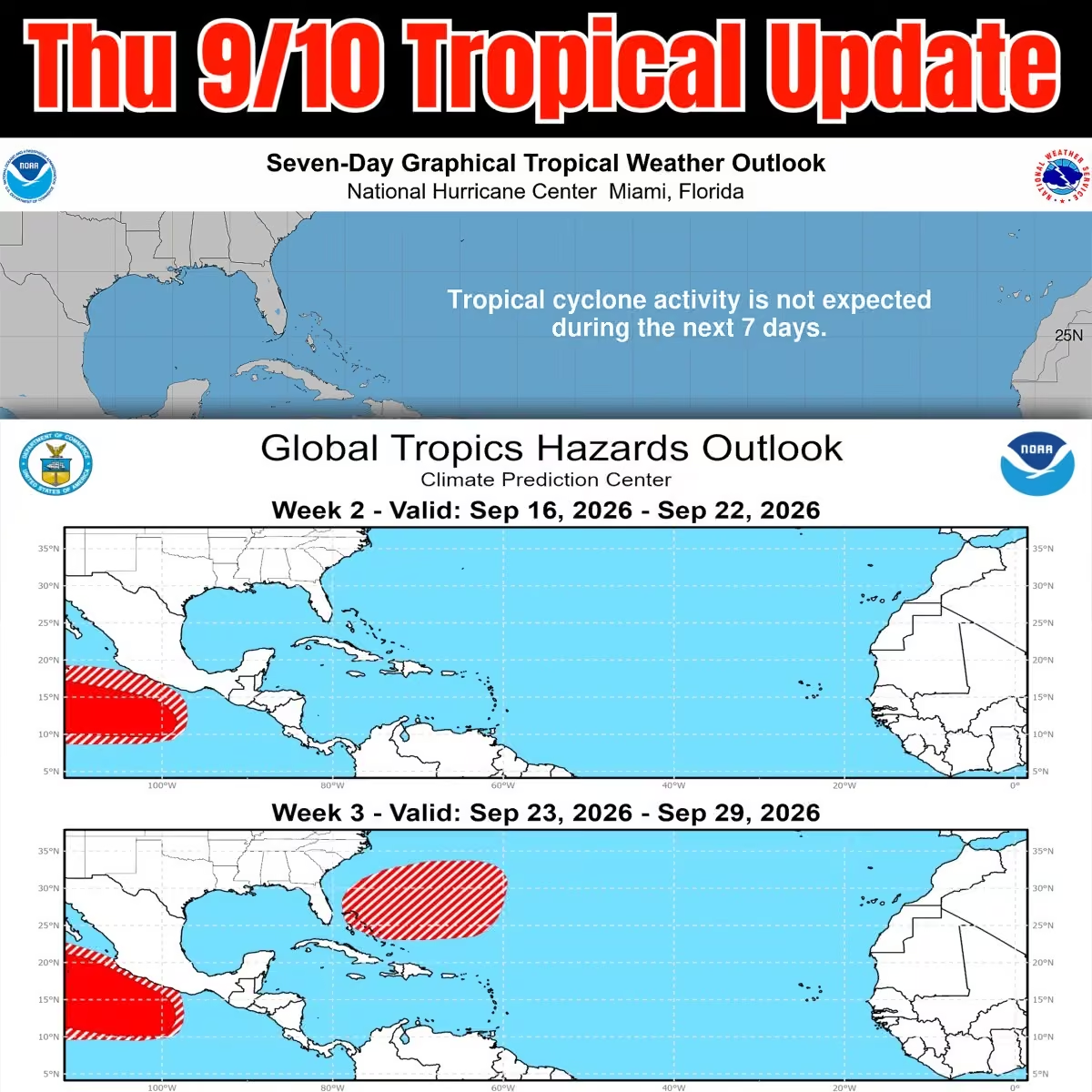 Mike's Weather Page
@tropicalupdate
Thursday Florida rains here. Repeat pattern. Things brewing as the day goes on. Most heads east to west. Classic pattern remains. Some get. Some don't. Some heavy. Some light. www.spaghettimodels.com
 Mike's Weather Page
@tropicalupdate
Just had Menchies for Sarah. Went outside. And I smelled rain. Julie thinks that's weird. I swear I can smell rain approaching. Anyone else?
 Mike's Weather Page
@tropicalupdate
Long line of storms and rain currently marching west. Wednesday action stretching across a big chunk of the Florida peninsula. 6pm radar here. www.spaghettimodels.com
 Mike's Weather Page
@tropicalupdate
Storms are currently popping across the state. Big thunder! Flowing to the west. Classic. www.spaghettimodels.com
 Mike's Weather Page
@tropicalupdate
Wednesday NHC Tropical Update. Nothing cooking. Working on some new graphics. Current satellite with latest update. www.spaghettimodels.com
 Mike's Weather Page
@tropicalupdate
Spotted today...
 Mike's Weather Page
@tropicalupdate
Rainfall totals through Friday. Classic Florida flow for us here on the west side of the peninsula. Storms working east to west through the day. Some decent numbers showing for some. Some like usual will get none. www.spaghettimodels.com
 Mike's Weather Page
@tropicalupdate
Wednesday's 09/09/26 "Daily Brew": x.com/i/broadcasts/1XxygwVByVZGM
Mike's Weather Page
@tropicalupdate
Frontal line still parked over middle Florida with a weak low showing over Gulf. This will pull precipitable water through the state today and combine with daytime heating to bring storms/rains again middle to east side later. Neat to see unfold. Nothing more than summertime normal. www.spaghettimodels.com
 Mike's Weather Page
@tropicalupdate
Looking ahead in the Tropics. Peak season is this week. And looks like the Atlantic will break the record for no Hurricanes before September 11th. GFS is starting to do GFS things. Spitting out a Hurricane here and there. But a quick check here with the EURO ensembles confirms things likely staying quiet for a bit. El Nino doing its thing as advertised. www.spaghettimodels.com
 Mike's Weather Page
@tropicalupdate
Florida weather today Wednesday. Similar to Tuesday. Middle state flowing east to west this afternoon and evening. Excessive rainfall map showing west central with chances of some heavy stuff. Isolated as always. www.spaghettimodels.com
 Mike's Weather Page
@tropicalupdate
Lots of chatter on this years possible record breaking El Nino. Historically it brings an active fall and winter for the south and east, especially Florida. All from a strong horizontal Pacific Jet Stream that fuels. Some memorable past El Nino fall/winter events for Florida here. Do any of these ring a bell?
 Mike's Weather Page
@tropicalupdate
 Mike's Weather Page
@tropicalupdate
Biggest surprise ever today. Thanks @FIRMANPower for the package. My first diecast @NASCAR racecar with logo on the hood. So freaking awesome!!! Such a great few years racing and representing. Love NASCAR. Have my whole life!
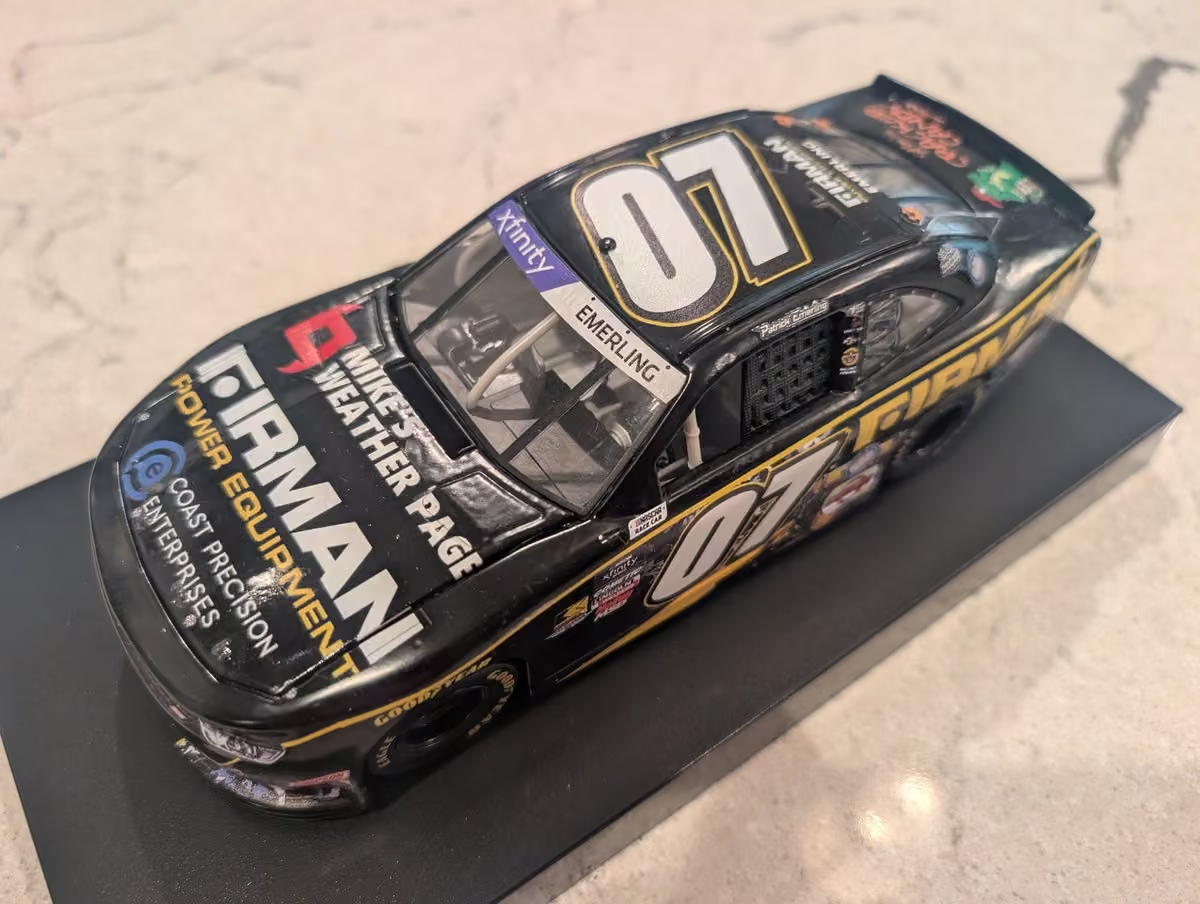 Mike's Weather Page
@tropicalupdate
New long-range tropics map released today. Take it with a grain of salt. No areas stand out to watch from what I can see. El Nino doing its thing keeping things in hibernation. Ready for a likely busy weather pattern across the south and east because of the same El Nino this fall and winter. www.spaghettimodels.com
 Mike's Weather Page
@tropicalupdate
Kinda odd to see a front making it into middle Florida early September. Low pressure helping instability across middle state. Storms popping here and there right now. www.spaghettimodels.com
 Mike's Weather Page
@tropicalupdate
Couple MWP events coming up soon! Our annual end of year Hurricane Benefit Party at Camp Margaritaville Auburndale, FL December 5th weekend. And the 6th annual MWP cruise on @Margaritaville at Sea middle March 2027. Tons of fun. Families welcome. Details below. Make plans now. Hope to see ya!
 Mike's Weather Page
@tropicalupdate
Tuesday's 09/08/26 "Daily Brew":: x.com/i/broadcasts/1dGYladegNQKX
Mike's Weather Page
@tropicalupdate
09/08 Tropical Update: Peak Season is in a couple days. It is all downhill from here. Nothing cooking on the horizon. NHC showing nothing the next 7 days. www.spaghettimodels.com
 Mike's Weather Page
@tropicalupdate
09/08 Walking and talking...
Mike's Weather Page
@tropicalupdate
Almost 100% of Kauai County in Hawaii is out of power early Tuesday AM because of Hurricane Lowell. Approximately 73K live there on the island. www.spaghettimodels.com
 Mike's Weather Page
@tropicalupdate
Hurricane Lowell impacting western Hawaii currently early Tuesday AM. Latest look here showing Hurricane and Tropical Storm force winds across the islands. Almost a direct hit. www.spaghettimodels.com
 Mike's Weather Page
@tropicalupdate
Checking Florida Tuesday weather. Flowing middle peninsula today east to west. Classic set your watch weather maybe. Heaviest I-4 south. www.spaghettimodels.com
 Mike's Weather Page
@tropicalupdate
Parts of Hawaii now under a very rare Tornado Watch as Hurricane Lowell approaches. www.spaghettimodels.com
 Mike's Weather Page
@tropicalupdate
Monday 09/07/26 Tropical Update: What's cooking as we near peak season? Hurricane Lowell update.
Mike's Weather Page
@tropicalupdate
Latest Monday look at Hurricane Lowell in the Pacific. Storm has trended east. Latest wind field here shows how some of the islands will be impacted. Hurricane Warnings for Kauai and Niihau. And Tropical Storm Warnings now for Oahu, which includes Honolulu.
 Mike's Weather Page
@tropicalupdate
Today is National Beer Lovers Day. And guess what? Spaghetti Model IPA is heading to @ABCWineSpirits across the state. This years features Longo on the can, and is properly called 'The El Nino Edition'. African grains included with an awesome sunset and tropical theme (and flavor). Goes good telling stories about the Saharan Dust we chat about all year. Cheers!
 Mike's Weather Page
@tropicalupdate
Florida Labor Day weather today. Weak frontal line north. Gulf high pressure. That is spinning in juice and flow in from the west. General idea of radar here. Anytime anyplace it appears. We just had some thunder here at home. www.spaghettimodels.com
Mike's Weather Page
@tropicalupdate
Weak frontal line juicing up storm chances for the upper Gulf Labor Day. SPC Storm Prediction Center upping to level 1/5. Timing later afternoon into evening likely. www.spaghettimodels.com
 Mike's Weather Page
@tropicalupdate
09/07 Tropical Update: We are nearing peak season. Nothing on the NHC 7 day forecast. And looking long-range not seeing any areas that stand out worth mentioning. EPS 10 day ensembles sleeping here. www.spaghettimodels.com
 Mike's Weather Page
@tropicalupdate
Happy Labor Day. An idea of who might get what today as far as rains go. As usual some get, some don't. Coastal areas and Florida peninsula showing highest chances. Enjoy the day! www.spaghettimodels.com
 Mike's Weather Page
@tropicalupdate
Rare Hurricane Warnings are now up for parts of Hawaii, Kauai and Niihau specifically. Been watching trends on Hurricane Lowell in the Pacific here. You can see the last several NHC advisories and how they have shifted closer east. www.spaghettimodels.com
 Mike's Weather Page
@tropicalupdate
It was, and still is for some, an electric Sunday afternoon and evening for the south and east. Satellite here showing lightning strikes with satellite and the sun going down. www.spaghettimodels.com
Mike's Weather Page
@tropicalupdate
First time at the movies in years. Did you know they have recliners now? Cool! But where's Galaga and Pac-Man? I brought quarters. Noticed the ticket office was gone. But popcorn, candy, and drinks still require a second mortgage lol. Getting ready to watch Toy Story 5. Hope I don't need a tissue. Last time I saw one I did. With the girls. Holding Sarah's hand. She's the perfect date!
 Mike's Weather Page
@tropicalupdate
Hurricane Lowell in the Pacific has made that hard turn right. Will pass west of Hawaii. Some impacts still likely. Tropical Storm Warnings for Kauai and Niihau. Current look here. www.spaghettimodels.com
 Mike's Weather Page
@tropicalupdate
Walking and talking. Used to listen to music, or a good podcast. But my earpods broke. It was the best thing ever. Now I hear birds. The quiet. Kids playing. Even the weather. Lets my mind explore and wonder. Like this road I walk on everyday. It is more than just a road. It is a memory. It all came back to me today. It is where Emmy learned to ride a bike. Where we practiced driving for the first time. Where we sat in the back of my truck watching lightning bugs one night. Such a great morning remembering these moments on this old road. Enjoy the days. They go by so dang fast!
 Mike's Weather Page
@tropicalupdate
Long-range looking. Updated EURO seasonal rain maps here. Showing what likely is on tap thanks to a strong El Nino. Increased rains SW. Increased rains SE, and east coast. Combined with winter could mean more snow for the south. El Nino brings a lower horizontal jet stream fueling all this. And big storms in from the Gulf. Historically severe. Lots of weather likely coming this fall/winter. www.spaghettimodels.com
 Mike's Weather Page
@tropicalupdate
Weak frontal line bringing in some storms today. And possible heavy rains. Latest updates here inching down towards the Florida Georgia line. www.spaghettimodels.com
 Mike's Weather Page
@tropicalupdate
Weak frontal line has been drifting south. Over 600 wind reports the past couple days here. Storms continue today inching more south towards the Florida Georgia line. www.spaghettimodels.com
 Mike's Weather Page
@tropicalupdate
09/06 Tropical Update: Peak season is in a few days. And nothing is on the horizon in the Atlantic. Rare for Labor Day weekend for sure. Enjoy! www.spaghettimodels.com
 Mike's Weather Page
@tropicalupdate
Nice day to take the Tesla out.
 Mike's Weather Page
@tropicalupdate
Some Florida storms brewing this Saturday afternoon. www.spaghettimodels.com
 Mike's Weather Page
@tropicalupdate
My 'unique' POV perspective while Storm Chasing Edouard. Actual audio and webcam video from inside the truck. A new format and idea I wanted to try. 'Through The Eyes - POV Edition'. Check it out!
Mike's Weather Page
@tropicalupdate
Hurricane Lowell in the Pacific still looks to pass west of Hawaii. It is a monster at 155mph and 925mb this AM. Some big rains still possible and coastal impacts. Current look here. www.spaghettimodels.com
 Mike's Weather Page
@tropicalupdate
Weak frontal line dipping south this weekend. Could be some storms to watch across the east coast Saturday and Sunday here. Latest SPC Storm Prediction Center outlooks here. www.spaghettimodels.com
 Mike's Weather Page
@tropicalupdate
Happy Labor Day Weekend! An idea of rains each day. Of course some get some don't. Heaviest brewing North Carolina today. That drifts south Sunday for South Carolina and Georgia. Then into Florida Monday. Weak frontal line dipping. Still sunshine here and there for most. Enjoy!
 Mike's Weather Page
@tropicalupdate
Big day for our Sarah. She started her first job! Serving coffee in the mornings. Look at that smile. She loved it so much. Thankful her High School offers the program. And so crazy to think she's a senior in the same High School I graduated from back in '91. The circle of life is in full effect.
 Mike's Weather Page
@tropicalupdate
We had them today, and pattern looks to remain this weekend. West Coast Florida popups over the water and also down in the Keys. Some make land. Some don't. Important to know if boating. Nothing lasts too long. www.spaghettimodels.com
 Mike's Weather Page
@tropicalupdate
Amazing to see three hurricanes spinning simultaneously in the Pacific. Current look here at all the action this Friday afternoon. When the Pacific is hot, the Atlantic is not. That's usually how it goes. www.spaghettimodels.com
 Mike's Weather Page
@tropicalupdate
All these northern storms start to slide south tomorrow Saturday. Large area under yellow 2/5 SPC alert levels. www.spaghettimodels.com
 Mike's Weather Page
@tropicalupdate
Interesting. We might be witnessing history for the 1st latest Hurricane to form in the Atlantic (if we even get one that is). The latest on record both formed on September 11th. Gustav in 2002 and Humberto in 2013. El Nino is contributing yes. But ironically 2013 wasn't El Nino. Forecast looking like this will verify. We will sea. www.spaghettimodels.com
 Mike's Weather Page
@tropicalupdate
Friday's 09/04/26 "Daily Brew":": x.com/i/broadcasts/1nGnRByDMgYGO
Mike's Weather Page
@tropicalupdate
Labor Day Weekend Tropical Update. NOTHING. Hard to believe as we usually have stuff cooking somewhere in the Atlantic this weekend. ENJOY!!!
 Mike's Weather Page
@tropicalupdate
Thunder! Walking and watching this AM. Hearing big rumbles so I pulled up radar. Yep! 25 miles away over the Gulf. Kinda drifting north and east a little. Coastal action for some. Cool to see and hear.
 Mike's Weather Page
@tropicalupdate
Labor Day Weekend rain totals. Fri/Sat/Sun here. Overall juicy pattern across the south and east. Not all day. Just some here and there. You know the deal. Some get. Some don't. Keep the radar on and enjoy your days! And be careful at those boat ramps. We stay away from them on this weekend haha. www.spaghettimodels.com
 Mike's Weather Page
@tropicalupdate
Northern storms have been relentless. Over 1/2 Million without power this Friday AM. More storms today in some of the same areas. System sliding towards the Mid-Atlantic and Carolinas tomorrow Saturday then lower southeast and northern Florida Sunday. www.spaghettimodels.com
 Mike's Weather Page
@tropicalupdate
Some chatter on Gulf blob today. New NHC update tonight showing nothing. Some rains/storms upper Gulf yes. But nothing organized likely. www.spaghettimodels.com
 Mike's Weather Page
@tropicalupdate
Google released a new anticipated tropical model today. WeatherNext 3. Here's is it's latest on Hurricane Lowell near Hawaii.
 Mike's Weather Page
@tropicalupdate
Rainfall from Tropical Storm Edouard was way more than expected. An estimated 1.3 Trillion gallons fell! With an area of 25 miles wide seeing 10"+. Data here at www.weather.city. Hardin County with the most.
 Mike's Weather Page
@tropicalupdate
Hawaii watching Major Hurricane Lowell. Latest Thursday models and EURO ensembles. Timestamps in white for general idea. Ensembles look spread yes. There average mean is in white. NHC also shown. www.spaghettimodels.com
 Mike's Weather Page
@tropicalupdate
Gulf blob getting blobbier. Not marked by the NHC this Thursday AM. Surrounded by weak low pressure off Tampa Bay. General flow NW. Keeping an eye on it for rain/storms the next day or so along the Gulf. www.spaghettimodels.com
 Mike's Weather Page
@tropicalupdate
Several days of storms up north have been ongoing. This is pushing a little more south. Tomorrow and Saturday showing into the Mid-Atlantic and Carolinas. Frontal line could pop some storms to watch. www.spaghettimodels.com
 Mike's Weather Page
@tropicalupdate
Thursday's 09/03/26 "Daily Brew": x.com/i/broadcasts/1DxleVkRnPRKL
Mike's Weather Page
@tropicalupdate
09/03 Walking and talking...
Mike's Weather Page
@tropicalupdate
09/03 Tropical Update: Shhhhhhhh. EURO showing things asleep has we head past the peak of Hurricane Season. Nothing on the NHC map this AM either. Doesn't mean things can change. But for now nothing is cooking. www.spaghettimodels.com
 Mike's Weather Page
@tropicalupdate
Another juicy day across Florida as a weak low hanging around. Coverage area today Thursday here paints idea. Many get. Some don't. General flow is up from the south heading NW. www.spaghettimodels.com
 Mike's Weather Page
@tropicalupdate
Thursday morning Gulf blob. Looking juicy out there. Weak low pressure over the whole SE area. This area moving off to the NW and should bring some extra pop later into tomorrow for the upper Gulf. Nothing 'tropical' expected. www.spaghettimodels.com
 Mike's Weather Page
@tropicalupdate
Who the heck is that guy? Yep. That's me. Had a clip on the @TODAYshow tracking Edouard today. Thanks for sharing.
 Mike's Weather Page
@tropicalupdate
Hurricane Lowell is currently south of Hawaii likely will be turning north. Could get close enough to watch early next week for some of the islands. www.spaghettimodels.com
 Mike's Weather Page
@tropicalupdate
Needed some gas and ended up finding the best home made BLT ever! Love memories like this. It's the little things in life!
 Mike's Weather Page
@tropicalupdate
Edouard satellite radar this morning was just amazing. Still with an eye and still with that classic 'look' at 5am. An overachiever for sure. www.spaghettimodels.com
 Mike's Weather Page
@tropicalupdate
I simply love to chase storms. And what a day it was chasing Edouard. Why do I do it some ask. I'm not exactly sure. The adventure. The unknown. The danger. The driving. The unfamiliar places. The people I meet along the way. The peaceful calm inside my truck. The perfect view of ever-changing weather. Many reasons I guess. This storm packed more punch than many expected I believe. Small strengthening systems at landfall always seem to overachieve. And the Gulf always helps fuel. Thanks for riding along and being part of this journey. Ready for what's next. Some quick clips here.
Mike's Weather Page
@tropicalupdate
09/02 Tropical Update: Nothing showing the next 7 days from the NHC. New Tropics Outlook showing Atlantic deeper into September. Almost predictable being peak season. Doesn't mean anything right now. www.spaghettimodels.com
 Mike's Weather Page
@tropicalupdate
Edouard leaving it's mark big time in Texas. Power outages over 80k this AM. And flooding risk just bumped to a rare 4/4 as storm lingers in eastern state. www.outage-pro.com
 Mike's Weather Page
@tropicalupdate
Florida remains juicy. Precipitable water keeping numbers 2"+. That usually means chances are high. And the sky is going to dump. Totals through weekend here. www.spaghettimodels.com
 Mike's Weather Page
@tropicalupdate
Edouard still parked over Texas this Wednesday AM. Current satellite shows impressive ball still exists. Flood map remains level 3/4 for today. www.spaghettimodels.com
 Mike's Weather Page
@tropicalupdate
What the heck. Is this real. Yes it is. Midnight radar. Edouard still looking the look. Over land! Why is he smiling at us???
 Mike's Weather Page
@tropicalupdate
True story tonight. Took me a couple drinks before I figured out why they were playing the Astros on all the TVs and speakers. Duh lol....
 Mike's Weather Page
@tropicalupdate
OK OK. I know my video getting out of the car today into the eyewall made some of you laugh. I don't fake it lol. I promise. It was windy. See. This verifies it was windy. A 90mph gust!!!
 Mike's Weather Page
@tropicalupdate
Leaving Edouard heading back to Houston. Was treated to this! The edge of the storm with an awesome sunset on the other side. What a day. What an adventure. Thanks for riding along!
 Mike's Weather Page
@tropicalupdate
Some of the most intense winds here in Beaumont, TX.
Mike's Weather Page
@tropicalupdate
LIVE Edouard Storm Chasing! x.com/i/broadcasts/1RKjpbjQLPeJw
Mike's Weather Page
@tropicalupdate
Incredible storm still ongoing. Technically I'm in the eye. Lots of power lines down. Some trees. Several flooding reports.
 Mike's Weather Page
@tropicalupdate
LIVE Edouard Storm Chasing! x.com/i/broadcasts/1pJdRDnQVWjKW
Mike's Weather Page
@tropicalupdate
Blinding rains TX/LA border...
Mike's Weather Page
@tropicalupdate
In the eyewall of Edouard!!! Intense moment. Just outside of Port Arthur, TX.
Mike's Weather Page
@tropicalupdate
LIVE Edouard Storm Chasing! x.com/i/broadcasts/1wGWjlpONQpKQ
Mike's Weather Page
@tropicalupdate
LIVE Edouard Storm Chasing! x.com/i/broadcasts/1aKbdEeOzRRJX
Mike's Weather Page
@tropicalupdate
LIVE Edouard Storm Chasing! x.com/i/broadcasts/1jGXgBwnEmBKZ
Mike's Weather Page
@tropicalupdate
Waiting for the storm... Streaming live.
Mike's Weather Page
@tropicalupdate
Latest Key Messages on Edouard. Making landfall near Port Arthur, TX soon. www.spaghettimodels.com
 Mike's Weather Page
@tropicalupdate
LIVE Edouard Storm Chasing! x.com/i/broadcasts/1dGYlaXRPENKX
Mike's Weather Page
@tropicalupdate
Hanging at the TX/LA line waiting on Edouard.
Mike's Weather Page
@tropicalupdate
LIVE Edouard Storm Chasing! x.com/i/broadcasts/1aKbdEemAkqJX
Mike's Weather Page
@tropicalupdate
Tuesday AM NHC update on the Tropics. Other than Edouard nothing else is cooking. Ex-Dolly dissipated and long range models are not showing much. www.spaghettimodels.com
 Mike's Weather Page
@tropicalupdate
Tuesday AM latest track from NHC on Edouard. Intensification discussion on possible fast organizing before landfall later today. Smaller eye storms can do that. Official numbers bumped to 65mph. 40mph now. www.spaghettimodels.com
 Mike's Weather Page
@tropicalupdate
Gulf is always tricky during the Tropics. Historically can produce during El Nino years. Edouard latest higher resolution 00z models here on tropicaltidbits.com. Trend a little stronger. We have a 970, 980, 990, and 1000mb range HWRF, HMON, HAFS. 3/4 hinting Hurricane. Lots to watch as the sun comes up tomorrow. Gearing up the rental car at daybreak. www.spaghettimodels.com
 Mike's Weather Page
@tropicalupdate
Latest 00z spaghetti models for Tropical Storm Edouard on tropicaltidbits.com. Tight tracks. Impacts both sides of center. Usually more on the right with this angle. Including surge numbers for sure. But not as wide reaching as with a larger storm we sometimes see. This one is small. Hurricane Watches are up, meaning maybe. Landfall tomorrow, with rainbands and storms leading up. www.spaghettimodels.com
 Mike's Weather Page
@tropicalupdate
Had a great day touring the @TampaElectric Operations Center along with @ByronDonalds today. Really appreciate this invite. And for having me say a few words to all the great lineworkers there in attendance. Fascinating to learn all the behind scenes work that takes place. Lineworkers definitely are heroes to so many! Thanks for all you do.


 Mike's Weather Page
@tropicalupdate
When systems show low level spin like Edouard has the past couple days they can definitely get going. Current radar showing that tonight along with 850/500 winds here. www.spaghettimodels.com
Mike's Weather Page
@tropicalupdate
Westbound and down. Taking a little gamble. Might catch some action from TD #5. If it gets sneaky. Small storms can do that.
 Mike's Weather Page
@tropicalupdate
Couple things watching our Gulf system. Tail ends of fronts sometimes produce. And small storms can be sneaky and intensify quicker. 12z HWRF and HMON showing on tropicaltidbits.com with the idea. Keeping a closer eye on this the next 12 hours or so.
 Mike's Weather Page
@tropicalupdate
PTC #5 is in the upper Gulf. Heading WNW. Midday satellite here. Getting that 'Tropical' look. A day or so over water before landfall tomorrow. Website and APP updated. www.spaghettimodels.com
 Mike's Weather Page
@tropicalupdate
PTC #5 is in the upper Gulf. Heading WNW. Midday satellite here. Getting that 'Tropical' look. A day or so over water before landfall tomorrow. Website and APP updated. www.spaghettimodels.com
 Mike's Weather Page
@tropicalupdate
We now have PTC#5 from Invest 97 in the upper Gulf. Landfall tomorrow with peak winds expected at 45mph. www.spaghettimodels.com
 Mike's Weather Page
@tropicalupdate
Monday's 08/31/26 "Daily Brew": x.com/i/broadcasts/1nGeLMnLklvKX
Mike's Weather Page
@tropicalupdate
Monday AM NHC tropical update. Couple spots. Invest 97 at 70% chance in upper Gulf. Rainmaker mainly for eastern Texas western Louisiana. Models peaking in the Tropical Storm range with 'landfall' around tomorrow (AM for some). Ex-Dolly chances lowered this update down to 10%. Shear doing its thing. And land interaction expected. Maybe a window when it clears all that. But models not too excited on development. Trends are your friends. That is the trend right now. Fizzle. Always watching of course for changes. www.spaghettimodels.com
 Mike's Weather Page
@tropicalupdate
Invest 97 in the upper Gulf looking juicy this AM with decent convection. Landfall towards eastern TX and/or western LA by tomorrow. Rainbands start later today/tonight. Should have TS Watches/Warnings up as this is within 24/36 hours. Models keeping in the Tropical Storm range. Rainfall the bigger impact. Some totals expected here. This could shift but paints general idea. Some sliding east seems possible. www.spaghettimodels.com
 Mike's Weather Page
@tropicalupdate
Monday AM satellite. Couple circled areas marked by the NHC. Invest 97 looking more organized. Heading NW. Will be making 'landfall' likely by tomorrow sometime western LA eastern TX. Models maxing in the Tropical Storm range. Ex-Dolly looking less than yesterday. Battling wind shear for sure. NHC keeping chances low on redevelopment as it heads NW. Models maxing in the Tropical Storm range, with many even showing a fizzle. Nothing on this one to be stressed with yet. www.spaghettimodels.com
 Mike's Weather Page
@tropicalupdate
Bunch of model data for Ex-Dolly. Top left intensity chart. Keeping in the Tropical Storm range. Top right wind shear. Strong winds the next couple days to deal with, then things relax. Middle right water temps. Bottom right humidity. Measures dry air. Bottom left spaghetti models. Right now not a lot of support Ex-Dolly gets too strong. But something to watch these next few days. If it hangs on and makes it to the lower Gulf, it could have a better chance to get spinning. www.spaghettimodels.com
 Mike's Weather Page
@tropicalupdate
Sunday night chances are up for Invest 97 in the Gulf. Current satellite showing continued convection. And some lower level spin. NHC mentions Tropical Storm Watches/Warnings might be coming soon for parts of TX/LA. Heavy rain the big impact to watch. Later Monday into Tuesday system makes it towards the WNW and 'landfall'. Ex-Dolly still being tracked near PR. NHC chances remain at 20%. www.spaghettimodels.com
 Mike's Weather Page
@tropicalupdate
Sunday's 08/30/26 "Daily Brew PM": x.com/i/broadcasts/1wxWjlbdMLpJQ
Mike's Weather Page
@tropicalupdate
A look at the tropics. Invest 97 with some clear spinnage. Models heading off WNW. NHC chances 50%. Intensity models max out at Tropical Storm and below. Ex-Dolly showing north of PR. Big rains for some as it treks WNW this week. Most models keeping Tropical Storm range. Always watching these two areas for homegrown action, especially in an El Nino year. Live tonight at 5pm ET with the latest. www.spaghettimodels.com
 Mike's Weather Page
@tropicalupdate
Sunday afternoon chances bumped up to 50% for the Gulf area of interest. Leftover front has been juicing things up. Little window to get spinnage at it heads WNW next couple days. www.spaghettimodels.com
 Mike's Weather Page
@tropicalupdate
Latest models on our couple areas the NHC is watching. General WNW flow for both. Evening video update tonight Sunday 5pm. www.spaghettimodels.com

 Mike's Weather Page
@tropicalupdate
08/30 Tropical Update: Couple spots on the NHC map. Invest 97 in the Gulf and leftovers of Dolly northern Caribbean. Both flowing generally WNW. Full breakdown later today. www.spaghettimodels.com
 Mike's Weather Page
@tropicalupdate
I love NASCAR. But why is it called a ballfield?
 Mike's Weather Page
@tropicalupdate
Dolly leftovers still looking juicy on satellite. Spaghetti models continue to run. General motion WNW. Strong shear expected the next few days. Some models try to get it back spinning end of the week. www.spaghettimodels.com
 Mike's Weather Page
@tropicalupdate
Daytona race forecast. Winds have shifted. Flow is slow. I can see it this AM. Clouds stagnant. Things will slide more east to west. We good to go for an awesome night. Zoom.. Zoom.
 Mike's Weather Page
@tropicalupdate
Dolly leftovers might try and get spinning later next week after it passes all the expected wind shear first. Latest weathernerds.org ensembles here showing general idea. EURO top. Google bottom. Most showing weak. NHC has the area marked 10%.
 Mike's Weather Page
@tropicalupdate
08/29 Tropical Update: Couple spots marked by the NHC Saturday AM. Both low chances at 10%. Gulf frontal leftovers and remnants of Dolly. Models not too aggressive on either. www.spaghettimodels.com
 Mike's Weather Page
@tropicalupdate
Hanging with the man. @BuschBeer on the pole. We celebrating! Cheers!!
 Mike's Weather Page
@tropicalupdate
Things got a little rowdy last night. Smoothed things over this AM over some Busch. Just kidding lol. Love the locals here. Always great to have them stop by. Thanks for all you guys do!!! And thanks for looking the other way maybe later tonight lol.
 Mike's Weather Page
@tropicalupdate
NHC dropped Tropical Storm status for Dolly this Friday AM. Too much dry air and shear. Current satellite. www.spaghettimodels.com
 Mike's Weather Page
@tropicalupdate
Friday AM standing and talking. Dolly and the tropics.
Mike's Weather Page
@tropicalupdate
Such an odd several days for a not so typical Florida summer. Frontal lines stalled across the south and east. Morning storms brewing along the west coast that move east throughout the day. Like clockwork. www.spaghettimodels.com
 Mike's Weather Page
@tropicalupdate
Friday AM EURO ensembles for Dolly. Showing the likely fizzle. Couple try and bring back after passing hostile conditions around the Caribbean. Not a forecast. Just an idea that can happen. www.spaghettimodels.com
 Mike's Weather Page
@tropicalupdate
Loving life here at Daytona tonight. Cheers! You only live once.
Mike's Weather Page
@tropicalupdate
Friday AM NHC track update on Dolly. Wind shear and dry air helping reduce intensity. Depression expected this weekend. Down the road leftovers showing on couple ensembles. But nothing solid to bet on yet. www.spaghettimodels.com
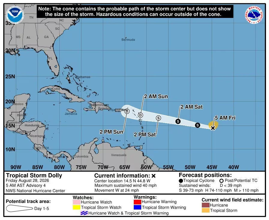 Mike's Weather Page
@tropicalupdate
Dolly intensity models. Keeping it weak. No stress yet. Thanks El Nino wind shear.
 Mike's Weather Page
@tropicalupdate
Live from Daytona. Thanks to @foxweather for having me on. And cheers to @BuschBeer for stopping by. They made the video too!
Mike's Weather Page
@tropicalupdate
Thursday 08/27 Tropical Update: We now have Tropical Storm Dolly. Here's the latest.
Mike's Weather Page
@tropicalupdate
Invest 96 satellite this Thursday AM. Some convection. Some spinnage. Might get classified before it nears the Caribbean Islands later this weekend. Strong wind shear expected to help try and tear apart. Most models do that. No stress yet. www.spaghettimodels.com
 Mike's Weather Page
@tropicalupdate
Thursday AM EURO/Google ensembles from weathernerds.org. Most showing that fizzle of Invest 96 by the Caribbean. Couple try and bounce back after. Which makes sense as a remote possibility. Low chance as of now. No stress. Could still be classified for a few days according to the NHC. www.spaghettimodels.com

 Mike's Weather Page
@tropicalupdate
Thursday AM NHC update. Invest 96. Might get organized enough to be classified. But expected to fizzle likely before the weekend officially from the NHC. Most models keeping it weak by the Caribbean. No stress yet. www.spaghettimodels.com
 Mike's Weather Page
@tropicalupdate
I'm not going to post something to worry about until there's something to worry about. Invest 96 still 60%. We will sea. Models still all over the place. Over 4 million follow MWP. Hope you know I'll raise interest when it's needed. Tonight is not the night. Cheers. No worries.
 Mike's Weather Page
@tropicalupdate
OK I get it. Some only want weather posts from MWP. Here's a only weather post. Just for you! Maybe I'll join 'onlyweather'. Cheers from Daytona!
Mike's Weather Page
@tropicalupdate
Happy National Dog Day... from Daytona.
 Mike's Weather Page
@tropicalupdate
Many models still fizzling out Invest 96 as it treks west. Few bring back. Overall steering here. Ensembles in lighter colors show that turn north of it remains. No stress. Thanks El Nino. No Daily Brew today. Enjoy the day! www.spaghettimodels.com
 Mike's Weather Page
@tropicalupdate
8/26 Tropical Update: Invest 96 chances lowered down to 60%. A good trend to watch far throughout the day today. Hostile conditions remain ahead. Models losing more interest. And Invest 95 went poof. www.spaghettimodels.com
 Mike's Weather Page
@tropicalupdate
Off the radar. Family time for a few days at Daytona. Invest 96 not a big worry right now. But I'll keep you updated no matter what. No Daily Brew in the AM. Maybe Thursday. See ya early I'll be posting the latest overnight runs.
 Mike's Weather Page
@tropicalupdate
Invest 96 remains at 70% this Tuesday afternoon. Latest spaghetti models keeping that nudge north. www.spaghettimodels.com
 Mike's Weather Page
@tropicalupdate
Tuesday afternoon storms possible. North Florida South Georgia. www.spaghettimodels.com
 Mike's Weather Page
@tropicalupdate
Lingering front today remains. Some heavy juice possible north Florida south Georgia. Totals here and maps. www.spaghettimodels.com
 Mike's Weather Page
@tropicalupdate
Tuesday's 08/25/26 "Daily Brew": x.com/i/broadcasts/1vJpPNwbdBMJE
Mike's Weather Page
@tropicalupdate
Tuesday AM EURO/Google ensembles for Invest 96 from weathernerds.org. Same general thinking. Some fizzle. Some develop. Many curve. Some weaker west first. Just too much spread to bet. But with El Nino, conditions towards the Caribbean are hostile. If it doesn't curve before it will have to pop on through to the other side if it has a chance, as Google thinks, and history. www.spaghettimodels.com
 Mike's Weather Page
@tropicalupdate
Tuesday NHC AM update. Invest 96 in the far Atlantic up to 70% chance to develop. NHC mentions some development possible. And also mentions some rougher conditions ahead. Models confirm. Some fizzle. Some curve. Some develop next week. Timing puts whatever near the Lesser Antilles, northward, this weekend. Little more fanning out of ensembles after. www.spaghettimodels.com
 Mike's Weather Page
@tropicalupdate
Look east Tuesday AM early AM. Perfect timing for the infamous jellyfish from SpaceX. Most the southeast and east coast has a chance to see it. Scheduled launch is 5:33am ET.
 Mike's Weather Page
@tropicalupdate
First batch of 00z spaghetti models for Invest 96 on tropicaltidbits.com. Showing that possible curve. www.spaghettimodels.com
 Mike's Weather Page
@tropicalupdate
Invest 96 now in the far Atlantic. NHC keeping chances at 60% tonight. Spaghetti models starting to run. Many curving. EURO here. www.spaghettimodels.com
 Mike's Weather Page
@tropicalupdate
It never rains twice a day. Yea right!!!
Mike's Weather Page
@tropicalupdate
Monday afternoon NHC update. Tropical wave off of Africa at 60%chance of development. Long trek west with some bumping north expected. Models not locked in. Many curve. Some fizzle. Long ways away. Invest 95 harmlessly east of Bermuda moving north. www.spaghettimodels.com
 Mike's Weather Page
@tropicalupdate
Monday storms brewing for eastern Carolinas. SPC posting update at noon here. www.spaghettimodels.com
 Mike's Weather Page
@tropicalupdate
Future curve on far Atlantic wave? If it develops then likely yes. Latest EURO here shows why. Fronts. We had them last year. We already have them this year. They help weaken the Bermuda high and allows that classic curve we often sea. If it stays weaker then likely heads more west opening up other ideas but for now many show a curve. Timing near the Caribbean this weekend (or north of it). Middle following week if Bermuda. Officially spot is marked by the NHC at 60%. Lots of time. www.spaghettimodels.com

Mike's Weather Page reposted
Space Jellyfish Alerts
@spacejellyalert
Space jellyfish alert!
Starlink 10-49 from SLC-40 in Florida on August 25, 2026 at 5:33:17 AM EDT could produce a space jellyfish. This occurs when a rocket and its expanding exhaust plumes are illuminated by the sun and observers are in local darkness.
The rocket will enter sunlight 05m25s after launch.
See a detailed prediction for your location: jellyfish.johnkrausphotos.com
Information as of 2026-08-24 09:55 UTC
 Mike's Weather Page
@tropicalupdate
Monday's 08/24/26 "Daily Brew": x.com/i/broadcasts/1AGRnZezjnYGl
Mike's Weather Page
@tropicalupdate
Monday morning ensembles tracking the far Atlantic wave that just plopped over water. Latest EURO/Google here on weathernerds.org. Timing still middle Atlantic end of this week. Lots of time. Some fizzle. Most curve. These are painfully long to track sometimes. But it is the season. Front have been the story this year (as last). They keep curve chances high. www.spaghettimodels.com
 Mike's Weather Page
@tropicalupdate
08/24 Tropical Update: NHC bumping African wave chances up to 60%. Now over water with that trek expected west. Many showing a curve. Some a fizzle. Some developing later next week. Yes next week. That is how long these take to make it across. Ensembles showing CONUS a very low risk right now (but not zero). Bermuda watching close. I will keep you updated. No stress yet for anyone. Invest 95 heading north in the middle Atlantic currently. BTW NHC website is down. This was the 2am graphic. New 8am updated soon. www.spaghettimodels.com
 Mike's Weather Page
@tropicalupdate
Sunday was wild here in Pinellas County. Rains came in the AM. And never left. Was watching radar all day and the sky was so saturated. Finally the sun peaked through around sunset. 24 hour totals here. Couple isolated spots with 5"+. www.spaghettimodels.com
 Mike's Weather Page
@tropicalupdate
Front line dangling across the south and east the next few days. Action today here. Storms possible with 2/5 SPC risk. And some isolated heavy rains. www.spaghettimodels.com
 Mike's Weather Page
@tropicalupdate
Could be some storms along the south and east tomorrow Monday. Frontal line lingering. Latest SPC here. Will be tweaked some in the AM. www.spaghettimodels.com
 Mike's Weather Page
@tropicalupdate
Tropical Storm Moke (not Mike) is just south of Hawaii. Most impacts staying offshore as it heads westbound. Current look here. www.spaghettimodels.com
 Mike's Weather Page
@tropicalupdate
Sunday night NHC update. Invest 95 sliding east of Bermuda going northbound. New wave fixing to exit Africa at 50%. Fizzle? Curve? Plenty of time to watch. www.spaghettimodels.com
 Mike's Weather Page
@tropicalupdate
Invest 95 staying east of Bermuda heading N/NE. NHC chances at 40%. www.spaghettimodels.com
 Mike's Weather Page
@tropicalupdate
 Mike's Weather Page
@tropicalupdate
What a great night celebrating our MWP beer release. Thank you all for coming out. Appreciate Tampa Bay Brewing Company and @ABCWineSpirits for this yearly opportunity.
Mike's Weather Page
@tropicalupdate
Where did this come from???
 Mike's Weather Page
@tropicalupdate
Latest Sunday AM EURO ensembles on African wave emerging. NHC marked at orange 50% already. Many showing the classic 'curve'. Timing puts middle Atlantic end of the week still. Will keep a watch on it. www.spaghettimodels.com
 Mike's Weather Page
@tropicalupdate
08/23 Tropical Update: Clump of storms coming off Africa now with 50% orange chance. Will be watching this week. Invest 95 east of Bermuda moving north. Area in the northeast Atlantic down to 10%. www.spaghettimodels.com
 Mike's Weather Page
@tropicalupdate
Tropical Storm Moke will pass south of Hawaii. Models keeping that confident. Some heavy rains likely for the Big Island. Current look here. www.spaghettimodels.com
 Mike's Weather Page
@tropicalupdate
NHC bumping chances on Africa wave to 40%. It hasn't emerged over water yet. That is expected Monday'ish. Models showing that long trek west with many bumping north. Still in the middle Atlantic this time next weekend. www.spaghettimodels.com
 Mike's Weather Page
@tropicalupdate
Gulf juice sliding east. Will it make it to land? Future radar said no. My eyeballs saying maybe. Noon radar here. www.spaghettimodels.com
 Mike's Weather Page
@tropicalupdate
Cooler on the coast this AM as some Gulf rains are incoming. Current radar here. Slowly fizzles out with more afternoon pattern center state sliding east later today. www.spaghettimodels.com
 Mike's Weather Page
@tropicalupdate
Saturday AM ensembles on future African wave. Hitting water early next week. EURO top. Google bottom. Showing placement 10 days from today. Slow tug north likely. Future curve showing on many. I will be tracking from the Daytona infield it appears. www.spaghettimodels.com
 Mike's Weather Page
@tropicalupdate
Saturday AM EURO ensembles on future tropical wave exiting Africa. Curve showing on most. EPS top. AI bottom. AI struggles development until it clears 60W. Plenty of time watch. No time to stress. www.spaghettimodels.com
 Mike's Weather Page
@tropicalupdate
08/22 Tropical Update: Few spots. Main one to watch up to 30%. Exiting Africa early next week. That trek west bumping north showing now from the NHC. Curve? Fizzle? More? Plenty of time to watch. Middle Atlantic staying east of Bermuda. Far north east Atlantic bringing some juice that way. www.spaghettimodels.com
 Mike's Weather Page
@tropicalupdate
Had some amazing news tonight. Wish I could share. But can't yet. Soon! But it puts MWP on the biggest stage. Enjoying some awesome music. Hope your Friday night is going great. You only live once!!! Cheers.
Mike's Weather Page
@tropicalupdate
Friday night NHC update. Three spots at 20%. New one off Africa a little interesting. As we have been discussing. Emerging from Africa early next week. Tons of time to watch. No stress yet. www.spaghettimodels.com
 Mike's Weather Page
@tropicalupdate
Hawaii with another close passing tropical system. This time it's Tropical Storm Moke. Some isolated heavy rains the big impact for the Big Island. Latest track here. www.spaghettimodels.com
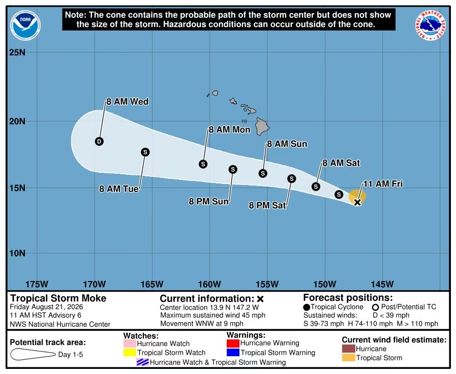 Mike's Weather Page
@tropicalupdate
Making things is fun. Especially beer. Check out our MWP Spaghetti Model IPA being canned here. Come to the release tomorrow Saturday August 22nd from 5-7pm at Tampa Bay Brewing Company (near Oldsmar). Meet the dogs. Get some swag. Get some MWP IPA. Eat. And give cheers with good friends and family.
Mike's Weather Page
@tropicalupdate
Check out this Atlantic spinner. Brought some nasty weather yesterday for the northeast. Not tropical. But cute. www.spaghettimodels.com
Mike's Weather Page
@tropicalupdate
Hawaii watching TD#2-C. NHC track and models keeping south of the islands. Rain a possible impact as it passes. NHC showing isolated areas here. www.spaghettimodels.com
 Mike's Weather Page
@tropicalupdate
Friday's 08/21/26 "Daily Brew": x.com/i/broadcasts/1YGNrbvZWpNGw
Mike's Weather Page
@tropicalupdate
EURO EPS and EURO AI 15 day ensembles. Far Atlantic wave showing. Many curving. Most curving actually. Still many days away before it even exits Africa. www.spaghettimodels.com
 Mike's Weather Page
@tropicalupdate
Next thing to watch? Africa wave still showing early next week plopping over water. Latest 10 day EURO/Google ensembles here on weathernerds.org. Most showing that bump WNW. Many curving eventually. Way to early to make bets. But wanted to share the latest at least. No stress heading into the weekend that is for sure. www.spaghettimodels.com
 Mike's Weather Page
@tropicalupdate
08/21 Tropical Update: NHC waking things up a little with a couple marked spots this AM. Both 20% chance. EURO showing middle Atlantic area heading north then northeast. Looks to miss Bermuda. Far northeast area who knows. That's heading east. Future wave early next off Africa might be watched. Will break that one down in my next post. www.spaghettimodels.com
 Mike's Weather Page
@tropicalupdate
Weather action today Friday for the east coast. Lingering front upping bigger rain chances. And storm potential. SPC bumping it to level 2/5. (yellow). www.spaghettimodels.com
 Mike's Weather Page
@tropicalupdate
Life. Family. Moments. You don't get many chances like these. Always make the most of it. Great time at dinner tonight. Love Longhorn. Love Dad still is able to get out and have a few drinks. Love Emmy and her boyfriend joining. And love Julie and Sarah always by my side. Lots of laughs. Will look back one day and remember this was a good day. You only live once. Cheers.
 Mike's Weather Page
@tropicalupdate
NHC Key Messages on TD2 in the Pacific. Models keeping just south of Hawaii. www.spaghettimodels.com
 Mike's Weather Page
@tropicalupdate
Storms flowing today across Florida. Current Thursday PM satellite looking spicy! www.spaghettimodels.com
 Mike's Weather Page
@tropicalupdate
BREAKING NEWS! New NHC area to watch. Well kinda. Heading east. 20%. Next...
 Mike's Weather Page
@tropicalupdate
Northeast rains expected to be heavy. Level 3/4 flood risk just posted. Totals here from NOAA possible with highlighted impact zone. www.spaghettimodels.com

Mike's Weather Page reposted
 Philip Klotzbach
@philklotzbach
On August 20 every year, Dr. Bill Gray would ring a bell denoting the start of the climatologically most active portion of the Atlantic #hurricane season. Historically, about 2/3 of all Atlantic hurricane activity occurs between August 20 - October 10.
 Mike's Weather Page
@tropicalupdate
We got some Florida spinnage! Wild satellite this Thursday AM showing. Nothing tropical out of this, just an upper low over the state. But clear as day. High pressure over the Gulf is pushing things towards the coast, which are then being pulled inward from this low pressure. Isolated popups throughout the day on tap. Some stronger expected north side of the state. www.spaghettimodels.com
Mike's Weather Page
@tropicalupdate
Hearing some thunder already this Thursday AM here in Oldsmar. High pressure flowing things towards the west side and throughout the state today, west to east, as upper low pulls in. Random popups are on tap once again. Some feisty. Upper Gulf and north Florida highlighted 1/5 from the SPC for stronger storms today also. www.spaghettimodels.com
 Mike's Weather Page
@tropicalupdate
Thursday's 08/20/26 "Daily Brew": x.com/i/broadcasts/1DxleVBnQejKL
Mike's Weather Page
@tropicalupdate
Tracking the tropics soon it appears. Strong wave signal emerging off Africa early next week. Latest EURO/Google ensembles here on weathernerds.org showing possible position in 10 days. That is a ton of time to watch. But interesting as Google is interested in this way more than it was for Invest 92/94. That slow bend WNW first to confirm. www.spaghettimodels.com
 Mike's Weather Page
@tropicalupdate
Some lingering front action for the east coast the next couple days. Friday here showing increased chances for flooding rains. And storms. Some lingers Saturday. Sunday looks nice. www.spaghettimodels.com
 Mike's Weather Page
@tropicalupdate
08/20 Tropical Update: NHC keeping tropics closed the next seven days. Model chatter continues on a wave off Africa early next week that might be watched. These are painfully weeks away literally. So much can change. And often does. But worth pointing out at least. EURO ensembles putting that low pressure idea middle Atlantic the end of the month. Will keep an eye on it for you. Carry on. www.spaghettimodels.com
 Mike's Weather Page
@tropicalupdate
I woke up last night to the sound of thunder...
Anyone else? Radar at 1am confirms. Sneaky little guy slid in from the north. Thought I was dreaming.
 Mike's Weather Page
@tropicalupdate
LIVE Florida Storm Chasing! x.com/i/broadcasts/1dxYlazVOqQJX
Mike's Weather Page
@tropicalupdate
Great interview today with @foxweather and @BobVanDillen. Lots of weather talk. Even chatted about my new beer from @TBBCo. Got to mention @ABCWineSpirits too!
Mike's Weather Page
@tropicalupdate
This kid is pretty smart!
 Mike's Weather Page
@tropicalupdate
High pressure is locked in over the Gulf the next several days. Through the weekend. It brings big heat yes. But also calms the waters. Max wave map here shows things nice and calm. For both the Gulf and Atlantic side. Nice for boaters and fishing that is for sure.
 Mike's Weather Page
@tropicalupdate
Florida storms giving a little more chance for today. SPC Storm Prediction Center upping chances a little deeper into the state. Looking at future HRRR doesn't look like a lot of coverage. But the storms that do form have plenty of heat to POP. www.spaghettimodels.com
 Mike's Weather Page
@tropicalupdate
Hawaii watching the tropics... again. Invest 90E is going to be intensifying and will be something to watch the next few days. Latest ensembles on polarwx.com and latest spaghetti models on tropicaltidbits.com here.
 Mike's Weather Page
@tropicalupdate
08/19 Walking and talking...
Mike's Weather Page
@tropicalupdate
Hurricane Lala is still spinning. Made it to MAJOR CAT 4 as it turns north way west of Hawaii. Interesting to watch. Water temps are around 81°. Say what! Other conditions are working however in its favor. No dust. No shear. It isn't always about water temps. Gulf was hot last year. We had Zippo. Lots of players when it comes to developing Hurricanes. Erin similar last year in the open Atlantic. Tropical Storm to CAT 5 in 30 hours'ish. Waters around 84°. www.spaghettimodels.com
 Mike's Weather Page
@tropicalupdate
Wednesday's 08/19/26 "Daily Brew": x.com/i/broadcasts/1jGXgBajOeyKZ
Mike's Weather Page
@tropicalupdate
It was a hot one Tuesday. Miami hit 100°. That tied a 1942 record for all-time high. Hard to do with all that water that surrounds. Places that showed actual high temperatures over 100° here. More heat today. And tomorrow. And the next day. And the day after that. Summer haha.
 Mike's Weather Page
@tropicalupdate
08/19 Tropical Update: Nothing cooking good looking. NHC keeping things shut down the next seven days. BUT. Ensembles starting to wake up a little on maybe a couple tropical waves. See them here on the EURO 15 day ensembles. We have seen this before. Fizzle. Curve. Too many days away to guess. Just letting ya know. Carry on. www.spaghettimodels.com
 Mike's Weather Page
@tropicalupdate
Rainfall totals expected through Friday PM here. A stalled frontal line helping with the juice. The Carolinas and Florida peninsula with some welcoming totals. A dusty dry Atlantic has limited normal Tropical Waves that help with the rains. Fronts help make up some difference.
 Mike's Weather Page
@tropicalupdate
Boys and their toys... dogs and beer. Hanging with my buddy David as we get ready to release Spaghetti Model IPA this Saturday at Tampa Bay Brewing Company. My dogs seemed heavy. Can't imagine his lol.
 Mike's Weather Page
@tropicalupdate
It's raining! It's raining! Been so long lol. Working recently on the Storm Chaser's front camera view out the windshield. Testing some stuff to make it better, nighttime especially. Woohooooo looks cool so far.
 Mike's Weather Page
@tropicalupdate
Just saw a bunch of lightning looking north here in Tampa. Looked at radar. And yes! Currently have some action sliding southbound. Already covered a bunch already. Current radar here. www.spaghettimodels.com
 Mike's Weather Page
@tropicalupdate
We got our stickers!
 Mike's Weather Page
@tropicalupdate
New tropics long range outlook released from NOAA today. Low chances of maybe something to watch. Fizzle? Fish storm? Who knows if anything can bust through these conditions. We will sea. No worries right now that's for sure! www.spaghettimodels.com
 Mike's Weather Page
@tropicalupdate
Where is Hurricane Season you might ask. We hear a lot about El Nino, dust, and shear. All of these help reduce storms. This graphic shows dust and dry air. Where we are now. And where we were in 2017, when we had Irma. And a busy season overall. The colors indicate dust and dry air. Tons today compared to then. Just last week we had Invest 92 and 94. NHC had decent odds of development. Then poof!!! Really shows how 2026 conditions are doing a number with things. Shear is also a big part of the slowdown. I'll show that separately. www.spaghettimodels.com
 Mike's Weather Page
@tropicalupdate
Summer with an extra dose of summer remains in the forecast for today. Millions in level 4/4 purple. That means heat index temps of 110-115+. Is it really that bad outside? Kinda feels normal to me. But I'm a native and love the heat so maybe I'm a little weird.
 Mike's Weather Page
@tropicalupdate
08/18 Tropical Update: Look who is winning. Eliminating all Atlantic and Gulf threats this season, so far. Dry air, shear, dust, all doing there thing.
The Dust Monster’s here, he sure is tough,
Atlantic and Gulf just can’t produce enough.
They bring storms, he brings the dry,
Shears them apart and waves goodbye!
 Mike's Weather Page
@tropicalupdate
This Saturday is the release party of MWP Spaghetti Model IPA at TBBC. Come hang with MWP friends and family for a fun night for sure. A brand new 'El Nino' edition for this year has been specially brewed. Can't wait to see you all. Steel drum band and free swag too. Cheers!!!
📍13937 Monroes Business Park, Tampa, FL 33635
📅Saturday August 22nd
🕔5pm-8pm
Event page: www.facebook.com/events/1587485736293552
 Mike's Weather Page
@tropicalupdate
Tropics went poof over the weekend. Invest 92 and 94 now just waves. Too much wind shear preventing development. Still can see them on satellite here. Bringing some rains/storms to those areas. www.spaghettimodels.com
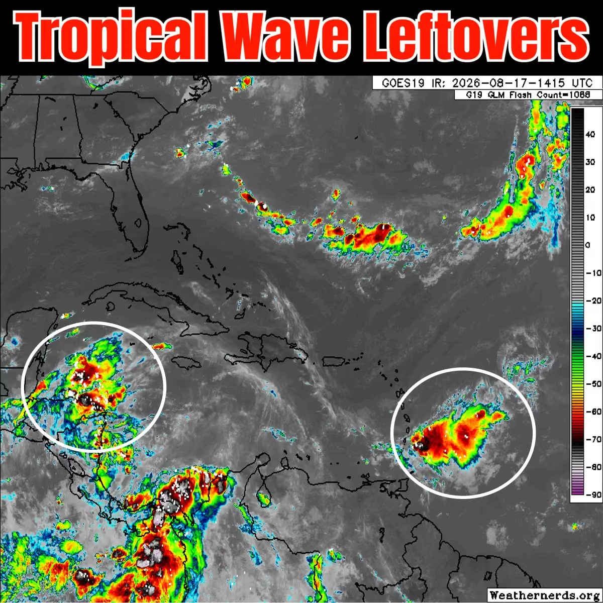 Mike's Weather Page
@tropicalupdate
Monday's 08/17/26 "Daily Brew": x.com/i/broadcasts/1RKZzBWWmWaKB
Mike's Weather Page
@tropicalupdate
Monday AM power outages from www.outage-pro.com. Hawaii with over 100k+. That is about 1/5th of the state. And Indiana still with over 100k+ from recent storms.
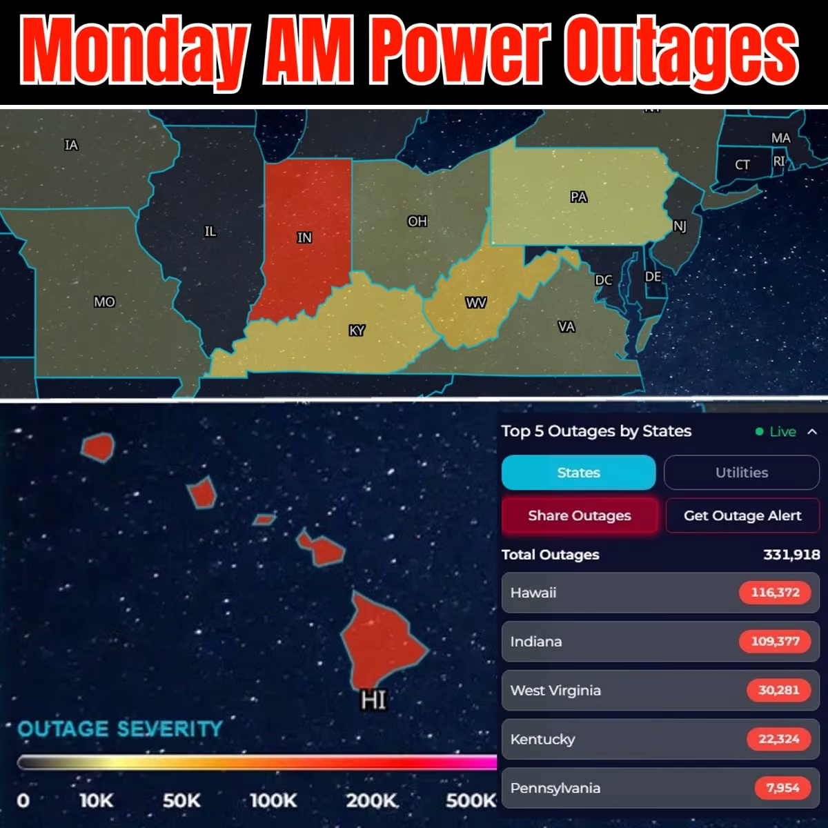 Mike's Weather Page
@tropicalupdate
Over 40 inches of rain fell for parts of the Big Island from Hurricane Lala. East side of the islands definitely got the most as the storm spun in rainbands off the Pacific. www.spaghettimodels.com
 Mike's Weather Page
@tropicalupdate
Radar for Hurricane Lala here. Crazy how the high mountains of Hawaii block and create a huge void in coverage. You have to use multiple locations to get an overall picture. www.spaghettimodels.com
 Mike's Weather Page
@tropicalupdate
08/17 Tropical Update: Models are starting to peak into September. Nothing standing out consistently. NHC showing nothing the next 7 days. Some ensembles curving next wave in the Atlantic. Maybe something for Bermuda to watch midweek next week, if anything comes from it. Western Atlantic and Gulf... zzzzzzz. www.spaghettimodels.com
 Mike's Weather Page
@tropicalupdate
High pressure remains locked over the upper Gulf. This means that big time summer heat stays put. No escaping it across the south and east. Current Monday warnings here. www.spaghettimodels.com
 Mike's Weather Page
@tropicalupdate
Off the radar today...
 Mike's Weather Page
@tropicalupdate
08/16 Tropical Update: Zzzzzzzzzz
 Mike's Weather Page
@tropicalupdate
Hurricane Lala brought snow to Hawaii. Yes it is true! Granted it was 13,803 feet up at Mauna Kea. But snow is snow, right. Crazy.
 Mike's Weather Page
@tropicalupdate
Sunday Sunday Sunday. Remember that Dodge commercial? Rainfall totals for today here. Not a lot overall. High pressure flow keeping it hot, and dry, for many. Whatcha got cooking? www.spaghettimodels.com
 Mike's Weather Page
@tropicalupdate
Looks like Hurricane Lala will miss a direct landfall on the Big Island. Looking back at the Google DeepMind model. On August 12th it showed the likely track missing also, almost mirroring Lala now. Seems that model does real well once a true low is established. Was the best model predicting Milton in 2024 when it was being tested. Interesting stuff. www.spaghettimodels.com
 Mike's Weather Page
@tropicalupdate
And just like that. POOF. Invest is 92 gone. Invest 94 at 0% chance (officially). Atlantic back to sleep. Shhhhhhh.
 Mike's Weather Page
@tropicalupdate
Finally made it. That sure was a long trip. Storm Chaser is ready to chase Lala in Hawaii. Wish us luck!
 Mike's Weather Page
@tropicalupdate
Lala is spinning towards Hawaii. Rare Hurricane Warnings are up for the Big Island. Current Saturday AM satellite here. Usually there is more activity in the Pacific during an El Nino, as this proves. www.spaghettimodels.com
 Mike's Weather Page
@tropicalupdate
Weather today Saturday. High pressure locked in over the southeast. And will be for days. Keeping the flow clockwise across eastern US. Some storms to watch later. Some reach into Florida. This also is helping bring the big heat. www.spaghettimodels.com
 Mike's Weather Page
@tropicalupdate
No tropics until September? Well. This came out this week. NOAA showing no areas to watch through the rest of August. That would be something. Right? www.spaghettimodels.com
 Mike's Weather Page
@tropicalupdate
A rare Hawaii Hurricane Warning. Lala tracking close to a direct landfall on the Big Island today. Huge rainfall incoming as storm spins by. Big waves/winds also expected impacts. www.spaghettimodels.com
 Mike's Weather Page
@tropicalupdate
08/15 Tropical Update: BOOM. And just like that. Chances are down. Way down. Hostile conditions are doing their thing. Invest 92 at 0% (was 80% a couple days ago). Invest 94 at 10% (was at 50% yesterday). Have a great weekend! www.spaghettimodels.com
 Mike's Weather Page
@tropicalupdate
Baseball is fun! Great to hang with Brett Phillips tonight at the Rays.
 Mike's Weather Page
@tropicalupdate
Tropical Update... from the Rays. Chances way way down tonight with Invest 92 and 94. I'm taking the night off!!! Cheers to that.
Mike's Weather Page
@tropicalupdate
My buddy! @PaulFox13
 Mike's Weather Page
@tropicalupdate
Go Rays! Tailgating from Julie's Tesla tonight lol. Enjoying some @BuschBeer in a little rain before the doors open. Doesn't get much better. For those who like to give me a hard time when I post a drinking picture... this is for you lol.
 Mike's Weather Page
@tropicalupdate
 Mike's Weather Page
@tropicalupdate
Friday afternoon NHC update. Development chances lowered. 92 now 10%. 94 now 40%. Wind shear here shows the big battle ahead. Add in dry air and bam... systems struggle. No stress heading into the weekend. Cheers! www.spaghettimodels.com
 Mike's Weather Page
@tropicalupdate
Added a new sticker on the Storm Chaser. Appropriate lol. Hint. The yellow one. I see these all over town so wanted to join the party.
 Mike's Weather Page
@tropicalupdate
08/14 Walking and talking...
Mike's Weather Page
@tropicalupdate
High pressure is parked over the upper Gulf. Bringing the heat the next several days. And clockwise flowing what rains we might get across the east and south. Today's coverage idea here. Similar Saturday with some stronger storms into the Florida panhandle showing.
 Mike's Weather Page
@tropicalupdate
Friday's 08/14/26 "Daily Brew": x.com/i/broadcasts/1rGmqppZEONGy
Mike's Weather Page
@tropicalupdate
Hawaii is under a Hurricane Warning from approaching Lala. An extremely rare Big Island possible landfall. Heavy rains a concern with flooding. And of course winds/waves/surge. Tropical Storm winds in the orange show most will feel. www.spaghettimodels.com
 Mike's Weather Page
@tropicalupdate
08/14 Tropical Update: Tracking a pair of Invests. 92 chances lowered again. Down to 20%. Dry air and shear doing its thing. No development likely as 'weaker goes west'. 94 hanging at 50%. General WNW track. Some models fizzle. Some develop. Several days to watch progress. Nothing solid yet to be stressed about. Top graphic is NHC. Bottom graphic from polarwx.com showing general model consensus on tracks. www.spaghettimodels.com
 Mike's Weather Page
@tropicalupdate
Another day of BOGO summer. Extreme Heat Warnings are up for north Florida and coastal GA/SC this Friday. Heat Indexes nearing 115°! Summer doing summer here across the southeast. I kinda like it actually. Must be the Florida native in me. www.spaghettimodels.com
 Mike's Weather Page
@tropicalupdate
Friday AM look at tropics. Invest 92 chances continue to drop. Once 80% now 30%. Hostile conditions remain. Rainmaker pushing west. Invest 94 holding steady at 50%. General trends still bumping WNW. Some models fizzle. Some keep it together. No stress yet. Especially since it's so far away. Timing puts it still east of the islands Tuesday/Wednesday'ish. www.spaghettimodels.com
 Mike's Weather Page
@tropicalupdate
Thursday PM 00z spaghetti models for Invest 94 on tropicaltidbits.com. Keeping that nudge north as it heads west. Intensity models bouncing around as questions on how it will handle some rougher conditions ahead. Should still be just east of the islands early week. Lots of time to watch.
 Mike's Weather Page
@tropicalupdate
People often ask how I started MWP. Well here you go. Hurricane Charley was 22 years ago. That was when Mike's Weather Page began. The storm was heading towards us here in Tampa. I ran across my first spaghetti models and fell in love with them. But found myself struggling to find them again the next day. Google wasn't really a thing back then. I was taking a website class at USF at the time. Decided it would be good practice to build one just for me. Called it Mike's Weather Page haha. Was also taking marketing (my main degree). I laugh telling this part of the story. Brilliant and creative name I chose right haha! Anyway. The idea was a webpage I could go to and get all the links, images, models, and more that I wanted. Added new ones every time I found one. Shared with only family and friends. That was the original idea. Fast forward to today and that is pretty much the same idea. This was a younger me on the couch way back then. Where MWP was born. On that little laptop. Before the kids were even born. Crazy. I consider all of you family and friends today. Just a few million more than in 2004 where it all began.
 Mike's Weather Page
@tropicalupdate
Lala heading to Hawaii. Hurricane Watches are up for the Big Island. Impacts begin tomorrow. On top of winds and waves, heavy rainfall expected for the island. Latest NHC Key Messages here. www.spaghettimodels.com
 Mike's Weather Page
@tropicalupdate
Thursday NHC 2pm update on the tropics. Development chances LOWERED for Invest 92. Now 60%. All that dry air and shear doing its thing. And even bigger shear ahead. Invest 94 behind still at 50%. Also dealing with some hostile conditions. Might have a new wave emerging from Africa to watch next. For now no stress with any of this. Cheers to that! www.spaghettimodels.com
 Mike's Weather Page
@tropicalupdate
See ya later little guy. We barely got to know each other. 2032 is when we get to meet again, when your name is returned in the NHC rotation. That is if they didn't retire the name. Doubt that will happen lol. 🤣
 Mike's Weather Page
@tropicalupdate
High pressure locked over the southeast the next few days. That brings the big heat. And there is no escape. Heat Advisories in orange taking over most the south and east. Summer... with a little extra summer mixed in.
 Mike's Weather Page
@tropicalupdate
Thursday's 08/13/26 "Daily Brew": x.com/i/broadcasts/1jGXgBBgBZzKZ
Mike's Weather Page
@tropicalupdate
Basic idea on track and timing of Invest 92 and Invest 94, regardless of development. Not an official forecast. Modeling found on polarwx.com. NHC showing odds at 80% for 92 and 50% for 94 this AM.
 Mike's Weather Page
@tropicalupdate
08/13 Tropical Update: Cristobal now a Depression moving harmlessly east in the upper Atlantic. Focus is on 92/94. Chances remain the same this AM. Both are showing well on current satellite below. 92 general trend is west and weak. Fizzle likely in the Caribbean. 94 showing little tug north. Models up and down on ideas. No worries yet with these. www.spaghettimodels.com
 Mike's Weather Page
@tropicalupdate
Thursday AM spaghetti models. Latest EURO/Google 10 day ensembles on weathernerds.org for both Invest 92/94. What does all this mean? Well. Google less enthusiastic. EURO little more, but not 100%. Confidence low basically on any worries right now. 92 weak into the Caribbean. 94 with some lift, with a few showing longer range chances. EURO also hinting next wave middle Atlantic in a week+. www.spaghettimodels.com
 Mike's Weather Page
@tropicalupdate
Thursday AM spaghetti models for Invest 92 on tropicaltidbits.com. Weaker west the old saying goes. Lots of shear in the Caribbean expected. NHC still at 80% this could develop before. Intensity models holding steady in the TD/TS range. Invest 92 is the wave in front of Invest 94 BTW.
 Mike's Weather Page
@tropicalupdate
Thursday AM spaghetti models for Invest 94 on tropicaltidbits.com. Little nudge north treking west. Some models fizzle, some keep weak, some develop. Will watch. NHC at 50% chance. Still will be east of the islands early week. Lots of time.
 Mike's Weather Page
@tropicalupdate
We now have Invest 94 in the far Atlantic. It is the stormy area behind Invest 92. Latest super ensemble blend here on polarwx.com shows general idea of both systems. NHC at 80% tonight for 92. 50% for 94. MWP website and APP updated with the latest on these. www.spaghettimodels.com @burgwx
 Mike's Weather Page
@tropicalupdate
Tonight's the night. Big meteor shower expected. Staying up later or getting up early? Rumor is there could be 100's an hour. Best advice is find somewhere dark. And look up. Midnight to dawn best time. BONUS: New Moon will help keep the skies extra dark too.
 Mike's Weather Page
@tropicalupdate
Invest 92 isn't expected to make it long once in the Caribbean. Why? El Nino helping. Strong wind shear is expected which helps rip apart storms. Most El Nino years have no activity in this area because of it. Also some dry air to the north helping. www.spaghettimodels.com
 Mike's Weather Page
@tropicalupdate
Wednesday 12z EURO EPS and AI models. Keeps Invest 92 fizzled in the Caribbean. And might try and develop the wave behind it. Nothing solid with that one yet. No stressing. www.spaghettimodels.com
 Mike's Weather Page
@tropicalupdate
Wednesday 08/12 Tropical Update: Tropical Storm Cristobal forms. Invest 92 heading west. New wave off Africa to watch behind.
Mike's Weather Page
@tropicalupdate
Wednesday 2pm NHC Tropical Update. Chances increased on orange wave to 40%. Red Invest 92 remains at 80% chance. www.spaghettimodels.com
 Mike's Weather Page
@tropicalupdate
Storms brewing later this Wednesday afternoon and evening for the Florida Georgia line. Flow north towards the south. www.spaghettimodels.com
 Mike's Weather Page
@tropicalupdate
Wednesday noon satellite for Invest 92. Got spinnage yes. Lacking some moisture as dry air surrounds. But trying to get going. NHC at 80% chance. General track west towards the Caribbean. Nearing the Lesser Antilles this weekend. www.spaghettimodels.com
Mike's Weather Page
@tropicalupdate
Hawaii fixing to have a possible tropical system. A rare direct hit too. Official PTC #1 is now out. Rainfall the big story so far. EURO showing feet of rain possible. www.spaghettimodels.com
 Mike's Weather Page
@tropicalupdate
Latest Wednesday spaghetti models for Invest 92 on tropicaltidbits.com (red NHC 80% area). General track west expected. Lots of wind shear in the Caribbean to try and pass through. Some fizzle it. Wave behind not an Invest yet but looks healthy.
 Mike's Weather Page
@tropicalupdate
Tropical Storm Cristobal forms in the north Atlantic. SAY WHAT!!! Yes it is true. 10% chance yesterday. Things can happen fast in the tropics. Especially with no shear or dusty dry air. Won't last long. Maybe 24 hours if that. Crazy year. www.spaghettimodels.com
 Mike's Weather Page
@tropicalupdate
Wednesday's 08/12/26 "Daily Brew": x.com/i/broadcasts/1RKjpbpLOlRJw
Mike's Weather Page
@tropicalupdate
Checking in on the far Atlantic wave marked by the NHC at 30%. Latest EPS/DeepMind ensembles here on polarwx.com. Fizzle down the road? Too early to tell but track ideas similar, today at least. Many days to watch as always. www.spaghettimodels.com
 Mike's Weather Page
@tropicalupdate
Hawaii watching the tropics. Rare to possibly have a direct hit on the islands. Invest 93C keeping that chance real. Latest models here on tropicaltidbits.com. Some showing Hurricane. Timing in a few days.
 Mike's Weather Page
@tropicalupdate
08/12 Tropical Update: Invest 92 at red 80%. Most showing a fizzle in and around the Caribbean. Big shear ahead. The yellow 30% wave behind has more model support down the road. Will be watching that one several days. The orange 50% hanging on. Fish storm yes.
 Mike's Weather Page
@tropicalupdate
Wednesday AM look at ensembles. EURO top. Google DeepMind bottom. Invest 92 showing that fizzle likely after it enters the Caribbean. The low pressure behind showing more model support still. Timing here next Monday. Still east of the islands. www.spaghettimodels.com
 Mike's Weather Page
@tropicalupdate
Talking tropics yesterday with @foxweather. Thanks for the opportunity and having me on each week for over a year now! Love tracking the tropics with all of you!
Mike's Weather Page
@tropicalupdate
Been walking. Talking. Eating healthy. Drinking less. Feeling great. Lost 15 pounds. Enjoying some @JimBeam tonight after several days off. Cheers. Feeling good. Sarah is a Senior. Emmy is in college. Life is good. It's the little things in life. No regrets. Reporting on the tropics. Doing what I love. Hope you love what I do. 22 years tracking the Tropics. Crazy. Thanks for following. Thanks for trusting. I got your back. Always! Cheers to you. Just one more......
 Mike's Weather Page
@tropicalupdate
Invest 92 first batch of spaghetti models here on tropicaltidbits.com this Tuesday night. General track west. Shear ahead will be a big hurdle. We will watch. Website and Mike's Weather Page APP updated with all the latest. NHC chances at 80% it will develop.
 Mike's Weather Page
@tropicalupdate
🔴 🟠 🟡 Tropics getting a bit more active tonight. Brand new wave off Africa at yellow 20%. Upper Atlantic area beating forecasts now orange 40%. Invest 92 up to red 80%. www.spaghettimodels.com
 Mike's Weather Page
@tropicalupdate
Storms today were absolutely intense. Over 1 million customers without power this Tuesday evening! www.outage-pro.com
 Mike's Weather Page
@tropicalupdate
First batch of EURO spaghetti models for Invest 92 in the Atlantic. Many fizzle system once in and around the Caribbean, likely due to heavy wind shear expected. Couple do hang on. But not enough to stress yet. Lots of hostile conditions to work through first. @Weathernerds
 Mike's Weather Page
@tropicalupdate
We now have Invest 92 in the middle Atlantic. Models bouncing around many ideas the past few days. Currently a little window to develop before hostile conditions ahead. www.spaghettimodels.com
 Mike's Weather Page
@tropicalupdate
The 70% NHC marked spot currently on noon Tuesday satellite. It's losing some love with models. There is a low pressure plopping off of Africa now that might be watched next. www.spaghettimodels.com
 Mike's Weather Page
@tropicalupdate
Happy first day of school Sarah. Can't believe you are now a senior in high school! Seems like yesterday you were heading off to Kindergarten. Sniff Sniff. Where the heck do the years go. My advice to new parents: DON'T BLINK haha. Great song too. Give it a listen.
 Mike's Weather Page
@tropicalupdate
Tuesday AM ensembles on the 70% NHC marked spot in the Atlantic. Still same thinking. No big concern yet. Some models still show a fizzle out. Some show that curve in the Atlantic. Still lots of shear and dry air to deal with in the days ahead. www.spaghettimodels.com
 Mike's Weather Page
@tropicalupdate
Thanks to @burgwx for the site.
Mike's Weather Page
@tropicalupdate
Tuesday's 08/11/26 "Daily Brew": x.com/i/broadcasts/1jxXgBgjeXkJZ
Mike's Weather Page
@tropicalupdate
08/11 Tropical Update: NHC keeping the red Atlantic low pressure at 70% chance this AM. Models bouncing around. From fizzle. From weaker west. From curving north into the Atlantic. No worries yet with this one. Dry dusty air to the north. Shear to the west. Other spots. 0% just some isolated rains heading west. Much needed. 10% heading east. Fish storm if that. www.spaghettimodels.com
 Mike's Weather Page
@tropicalupdate
Big heat returns to Florida and the east coast today. Heat Advisories taking over the phone alerts this AM for many. I got mine. High pressure has parked itself over the southeast. Several days of this ahead. It is summer. www.spaghettimodels.com
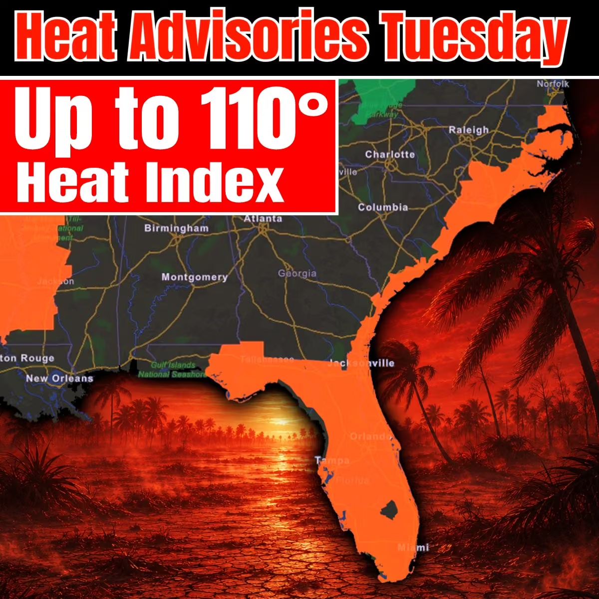 Mike's Weather Page
@tropicalupdate
🔴 NHC bumping chances on Tropical Wave to 70% red tonight. General nudge north expected as it heads west. Many curve close to Bermuda. Some fizzle with dust and shear. Plenty of time to watch. www.spaghettimodels.com
 Mike's Weather Page
@tropicalupdate
Monday afternoon 12z EURO ensembles on 60% NHC Atlantic spot. Curve likely still showing... or a fizzle with all that dry air and shear ahead. Will keep watching. No stress! www.spaghettimodels.com
 Mike's Weather Page
@tropicalupdate
Hawaii watching tropics close. Invest 93C could develop. Some models showing Hurricane. Tracks have shifted back north close to the islands. Timing later week into this weekend. Latest here on tropicaltidbits.com. With El Nino years the Pacific often is more active.
 Mike's Weather Page
@tropicalupdate
08/10 Walking and talking...
Mike's Weather Page
@tropicalupdate
Timing of circled area. If it hangs on of course. Chances this Monday AM from the NHC at 60%. Lots of dusty dry air to the north. And wind shear ahead end of the week/weekend. Many curve it around Bermuda. Few inch more west. Several days to watch. No reason to worry right now. It's hurricane season. Tropics happen. Sometimes. www.spaghettimodels.com
 Mike's Weather Page
@tropicalupdate
Tropics in a nutshell. Wind shear showing through the Caribbean... typical of El Nino years. Area #1 marked by the NHC at 10% likely gets shredded. Some rains for the Lesser Antilles first. Area #2 marked by the NHC at 60% with little bigger window to develop. Healthy today on Monday AM satellite. Has to deal with upcoming shear over the weekend. Map here dated 8/16 shows this shear and where #2 likely will be. Circled question marked area is where some models are showing continued development chances as conditions become a little more favorable for that. Steering? Many curve. Some close to Bermuda. Couple little more west to watch. Way too early to worry... to cancel anything... or to stress. Just be aware at this stage. It's the tropics. They happen. We just try and reason with hurricane season! www.spaghettimodels.com
 Mike's Weather Page
@tropicalupdate
Monday's 08/10/26 "Daily Brew": x.com/i/broadcasts/1XGygwmNryvxM
Mike's Weather Page
@tropicalupdate
08/10 Tropical Update: Few spots on the NHC map. Only one worth really watching is the far Atlantic wave up to 60%. General west motion with some tug north. Curve showing eventually on many. But not all. Timing puts whatever it is just east of the Caribbean next weekend. Lots of time to watch. Lots of models to watch. Lots to battle... with dust, dry air, and shear all ahead. But worth watching and keeping an eye on if it can make it past all that. www.spaghettimodels.com
 Mike's Weather Page
@tropicalupdate
Watching the Atlantic. Overnight Monday EURO and Google ensembles here on weathernerds.org. Dominant area showing the next 10 days with majority bumping WNW then possible curve. Few outliers bumping little more west today, with Google some too. Lots of time to watch. Other marked area nearing the Caribbean still showing a fizzle likely. www.spaghettimodels.com
 Mike's Weather Page
@tropicalupdate
Sunday 08/09 Tropical Update: NHC highlighting three areas to watch. Here's the latest.
Mike's Weather Page
@tropicalupdate
Sunday night NHC update. New area moving off to the east at 10%. Fish storm. Weak low still moving west at 20%. Hostile shear ahead of that one. 50% still with decent model support. Eventual bump north'ish likely. X marks the spots where they are right now.
 Mike's Weather Page
@tropicalupdate
Yes or No? Julie put me in charge of the camper interior decorating. I kinda like it!
 Mike's Weather Page
@tropicalupdate
El Nino historically brings flooding, snow, severe weather, and tornados to Florida during fall, winter, and sometimes spring. Here are past El Nino years and some events that stood out. This year could be a record El Nino. We will see if Mother Nature repeats herself. Storm Chaser is ready.
 Mike's Weather Page
@tropicalupdate
El Nino brings wicked weather to the southeast, especially Florida, late year / early year. Historically most every El Nino fall/winter has had flooding, severe weather, tornadoes, and even snow. Latest NMME maps here on tropicaltidbits.com shows average rainfall anomalies for Dec/Jan/Feb. A hint of things to likely come. That is if history repeats. www.spaghettimodels.com
 Mike's Weather Page
@tropicalupdate
Hawaii watching the tropics. Invest 93C at 90% chance to develop from the NHC. Ensemble tracks take it close with some pull to the south of the islands. Timing there later week if any impacts. www.spaghettimodels.com
 Mike's Weather Page
@tropicalupdate
Looking at the tropics and the EURO ensembles. Couple spots on the NHC radar. 1st spot runs into wind shear entering the Caribbean and likely goes poof. 2nd spot curving with a little better window to develop. Timestamps give idea on timing. Just one model but a good model to look at for ideas. www.spaghettimodels.com
 Mike's Weather Page
@tropicalupdate
We hear a lot about wind shear in El Nino years. These are strong upper level winds that tear apart organizing tropical systems. NHC currently watching two areas. #1 expected to run into this wind shear reducing chances of development. #2 might be curving more north into areas with less wind shear thus giving it more favorable conditions to develop. Happy Sunday! www.spaghettimodels.com
 Mike's Weather Page
@tropicalupdate
Sunday AM ensembles here on weathernerds.org. Couple spots being watched by the NHC. #1 showing a west track but most fizzle any chances in the Caribbean. Strong shear from El Nino helping. #2 with more model support. Many showing the classic curve. These are 10 days ensembles giving an idea where things might be then. Long track African waves take a week+ to watch. No stress yet with any of this. Always watching here at MWP. www.spaghettimodels.com
 Mike's Weather Page
@tropicalupdate
08/09 Tropical Update. NHC keeping chances the same on a couple spots to watch in the far Atlantic. 20% with some strong shear ahead as it nears the Caribbean, keeping long-range chances down. 40% with decent model support on development. Hasn't even left Africa yet so a lot of time to watch. EURO keeping the curve towards Bermuda. Always too soon to know for sure. Still east of the Caribbean this time next week. www.spaghettimodels.com
 Mike's Weather Page
@tropicalupdate
Atlantic Gulf Stream blob stays offshore for Sunday. Heaviest remains just off the SC/NC coast. Rainfall totals expected here showing widespread summertime action. Here. There. Anywhere. Nowhere. www.spaghettimodels.com
 Mike's Weather Page
@tropicalupdate
Saturday NHC pm update. African wave train beginning to start up. New area fixing to emerge has chances increased to 40%. Area in front still at 20%. Lots of time to watch these. If they become named or fizzle. www.spaghettimodels.com
 Mike's Weather Page
@tropicalupdate
Africa is starting to send the waves. NHC watching a couple now with two highlighted yellow. Latest operational runs here on tropicaltidbits.com showing low pressure support this time next Saturday. Long ways away to keep a watch on things. EURO starting to show that classic 'curve'. But always too soon to bet. www.spaghettimodels.com
 Mike's Weather Page
@tropicalupdate
Couple spots now to watch from the NHC in the Atlantic. Updated Saturday outlook here. www.spaghettimodels.com
 Mike's Weather Page
@tropicalupdate
Who gets rain today Saturday? Gulf Stream Blob bringing extra juice to coastal FL/GA/SC. Little less for everyone else as Tropical Wave steals the show. Pulling N then NE. Less rains tomorrow. www.spaghettimodels.com
 Mike's Weather Page
@tropicalupdate
Good Saturday morning Gulf Stream Blob. Tropical Wave sliding more N/NE today bringing heavier rain chances along GA/SC coastal areas. Little less across Florida today and tomorrow as this pulls out. No development expected close to the coast. www.spaghettimodels.com
 Mike's Weather Page
@tropicalupdate
Latest EURO and Google ensembles on next week's Tropical Wave marked by the NHC. Still east of the Caribbean by end of week. August 16th here. Some showing pull NW. Timing of any approaching front and strength of Bermuda High determines a lot. Lots of time to watch. Few ensembles still showing separate low nearing the Caribbean August 12th/13th, but not enough for NHC to mark. Models at www.weathernerds.org.
 Mike's Weather Page
@tropicalupdate
08/08 Tropical Update: NHC marking new spot to watch next week. 20% chance low pressure develops from expected Tropical Wave off Africa. www.spaghettimodels.com
 Mike's Weather Page
@tropicalupdate
Sunset tonight was surreal!
Mike's Weather Page
@tropicalupdate
Happy National Beer Day! Make sure you get your Spaghetti Model IPA soon from @TBBCo and @ABCWineSpirits. An awesome tropical blend with an even more awesome label. Beer release party is August 22nd 5-8pm at TBBC. Come hang, see Louie and Longo, drink, eat, and have a great time!!! Cheers.
 Mike's Weather Page
@tropicalupdate
Friday 2pm radar. Juice is flowing in from the Atlantic across the state. Peninsula did a rain dance and it worked! www.spaghettimodels.com
 Mike's Weather Page
@tropicalupdate
More Florida storms today likely. Yesterday here looking towards Tampa.
 Mike's Weather Page
@tropicalupdate
Friday's 08/07/26 "Daily Brew": x.com/i/broadcasts/1AxRnnQdNpjxl
Mike's Weather Page
@tropicalupdate
08/07 Tropical Update: NHC keeping things shut down the next 7 days. Even with some model support out in the far Atlantic there isn't strong enough proof to go with a yellow circle. We are nearing middle August with nothing brewing. Cheers to that. www.spaghettimodels.com
 Mike's Weather Page
@tropicalupdate
08/07 Walking and talking...
Mike's Weather Page
@tropicalupdate
Tropical juice flowing across the Sunshine State today Friday. Tropical Wave over the Atlantic helping pump in more rain across the peninsula. Flow is basically east to west once again. Isolated heavy stuff possible again. Welcome home summer rains. www.spaghettimodels.com
 Mike's Weather Page
@tropicalupdate
Overnight models still teasing idea of some MDR, Main Development Region, low pressure later next week. Ensembles have been off and on the idea too. Latest on tropicaltidbits.com. Nothing solid or close enough to even stress about. Just keeping you up to date.
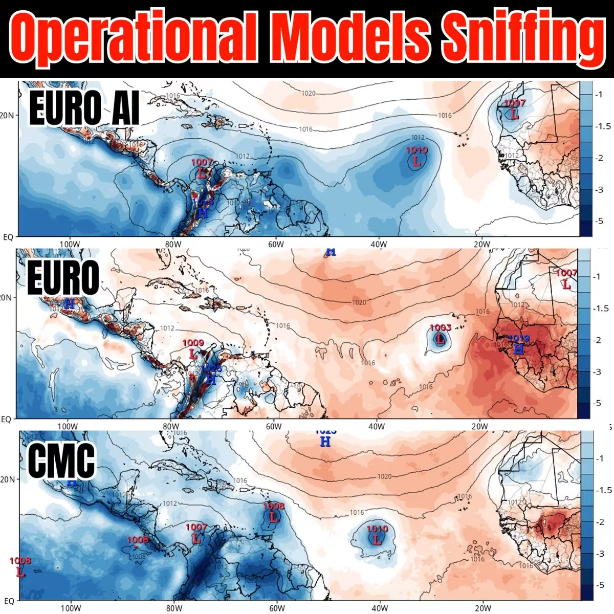 Mike's Weather Page
@tropicalupdate
Friday AM satellite. Tropical Wave making it's presence known as it nears the southeast. Increased rains and storms for Florida the next couple days. Blob turns more N/NE juicing east coastal areas too. K development from this. www.spaghettimodels.com
 Mike's Weather Page
@tropicalupdate
I can't believe football is starting. NFL kickoff tonight.
 Mike's Weather Page
@tropicalupdate
Little afternoon thunderstorm here in Tampa. Watching it roll in from the east.
Mike's Weather Page
@tropicalupdate
Time-lapse of storms coming across Tampa Bay this afternoon.
Mike's Weather Page
@tropicalupdate
LIVE Florida Storm Chasing! x.com/i/broadcasts/1RJjppgDXyjKw
Mike's Weather Page
@tropicalupdate
NOAA updated their Hurricane Outlook for the rest of the 2026 season. Higher chances more of a below average year.
 Mike's Weather Page
@tropicalupdate
Rains and Storms brewing today middle Florida and moving towards the west. Healthy line likely across the peninsula. Classic summer pattern, for a couple days at least. www.spaghettimodels.com
 Mike's Weather Page
@tropicalupdate
Updated Florida drought map released today. Little better. But not a lot. Still a few areas in level 3/4. Rainy season helping some. Definitely better than a couple months ago. www.spaghettimodels.com
 Mike's Weather Page
@tropicalupdate
Thursday's 08/06/26 "Daily Brew": x.com/i/broadcasts/1RKZzzazPkrKB
Mike's Weather Page
@tropicalupdate
08/06 Tropical Update: ZIPPO! New Global Tropics Map is out. And guess what. Nothing showing through most of August. Imagine nothing to track in a sometimes busy August. We will sea. El Nino, cold fronts, dust, cooler waters, all doing their thing. www.spaghettimodels.com
 Mike's Weather Page
@tropicalupdate
See this little blob by the Bahamas? Well its just a blob. Going to hug around the Bermuda high the next couple days, upping some rain chances along the way. Thursday/Friday/Saturday rains are a little higher across the SE with its help. Sunday little less.
 Mike's Weather Page
@tropicalupdate
Some overnight ensembles still picking up on far Atlantic wave. EURO here with a little more support towards the Lesser Antilles around August 12/13th. BUT. As with most El Nino years the conditions become very hostile the farther west you go. And most ensembles fizzle after. Nothing from the NHC on this one yet. Tropics remain asleep. www.spaghettimodels.com
 Mike's Weather Page
@tropicalupdate
Increased rain chances the next couple days for the southeast. Tropical wave sliding in from the western Atlantic helping boost the juice. Lingers into Saturday with Sunday lessening up. www.spaghettimodels.com
 Mike's Weather Page
@tropicalupdate
LIVE Florida Storm Chasing! x.com/i/broadcasts/1oKMvvoZOQRGQ
Mike's Weather Page
@tropicalupdate
The sun is huge tonight. Crazy!!!
 Mike's Weather Page
@tropicalupdate
Longo made it on Fox Weather today. He stole the show!
 Mike's Weather Page
@tropicalupdate
Wednesday 08/05 Tropical Update: New CSU Hurricane Forecast released today. Watching Atlantic down the road. Weather in a nutshell.
Mike's Weather Page
@tropicalupdate
Tropical wave watching? Big blob currently coming off Africa has a few ensembles sniffing. Not all. But some. Timing would put it near the Caribbean August 12th'ish if it survives this season's hostile conditions. EURO AI likes it the most. Google GENC not at all. Nothing from the NHC. Just passing it along. www.spaghettimodels.com
 Mike's Weather Page
@tropicalupdate
Talking tropics and some weather on @foxweather with @BobVanDillen and @JaneMinarWX today. Thanks for having me on!
Mike's Weather Page
@tropicalupdate
Florida weather flow does a U-turn Thursday. Atlantic tropical wave moving in from the west will shift winds and pattern across the state for a few days. Rains build east to west with some classic set your watch afternoon/evening storms for the west coast. HRRR tomorrow early afternoon pictured here. www.spaghettimodels.com
 Mike's Weather Page
@tropicalupdate
The 2026 Hurricane Season Outlook was updated today from CSU. Still calling for a below average season ahead. They predict 7 more names, with 4 being Hurricanes and 1 of those being a Major. We will sea. It only takes one. El Nino bringing hostile conditions as expected reducing season activity.
 Mike's Weather Page
@tropicalupdate
Wednesday's 08/05/26 "Daily Brew": x.com/i/broadcasts/1DGLddzMVQRGm
Mike's Weather Page
@tropicalupdate
8/05 Tropical Update: Nothing cooking as we enter the second week of August. Tons of dry air, lack of moisture, and wind shear currently preventing things from getting going. Little juice east of Florida might bring some rains end of week into the weekend for the south and east. Far Atlantic wave mentioned yesterday never got circled. Looks to be drying up already. New wave coming off Africa has a little model support. But nothing to stress about yet that is for sure with these conditions. www.spaghettimodels.com

Mike's Weather Page reposted
NWS Weather Prediction Center
@NWSWPC
#wpc_md 0946 affecting coastal areas of North and South Carolina, #ncwx #scwx, www.wpc.ncep.noaa.gov/metwatch/metwatch_mpd_multi.php?md=…
 Mike's Weather Page
@tropicalupdate
Florida led the way in 7 day rainfall totals. Trillions of gallons fell with the Big Bend getting the most. Some places 20"+. Over 23 Trillion pounds of water fell. Crazy right! Data found at weather.city. Cool new website I found.
 Mike's Weather Page
@tropicalupdate
Wednesday AM satellite showing some rain/storms east of Florida. This was picked up on a few models days ago as maybe a low pressure area to watch. Nothing currently with it. But does look to swing towards the Bahamas and south/east late week into the weekend. Might bump up some rains and coastal action. www.spaghettimodels.com
 Mike's Weather Page
@tropicalupdate
Early Wednesday radar before sunrise. Another morning of Gulf juice inching in. Lot less than prior days that's for sure. North flow inching east. Might be a little lightning. Isolated waterspout sometimes in these too. www.spaghettimodels.com
 Mike's Weather Page
@tropicalupdate
Me trying to talk about weather... When there is no weather.
 Mike's Weather Page
@tropicalupdate
 Mike's Weather Page
@tropicalupdate
Healthy far Atlantic wave has plopped over water. Has some spinnage yes. BUT... Lots of dry air above and ahead. Wind shear in the Caribbean ahead because of El Nino. And Cooler than 'normal' water temps. All this likely keeping development chances low. But am guessing NHC might mark. Something like 20% mentioning brief window of development chances before conditions ahead become unfavorable. We will sea. No stress either way! www.spaghettimodels.com
 Mike's Weather Page
@tropicalupdate
08/04 Walking and talking...
Mike's Weather Page
@tropicalupdate
We got a spinner! Mid-level low pressure parked over Georgia this AM. 1) Spinning down dry air. 2) Spinning up storm potential to inland North and South Carolina. 3) Flowing rain juice into middle Florida and coastal east coast states. Cool yes! www.spaghettimodels.com
 Mike's Weather Page
@tropicalupdate
Tuesday's 08/04/26 "Daily Brew": x.com/i/broadcasts/1nxeLLgwvXPJX
Mike's Weather Page
@tropicalupdate
End of week moisture push in from the east. Merging with leftover frontal line will up some rain chances across the Bahamas then Florida and the south/east. At one time a few models picked up on possible development but conditions remain too hostile. Rain chances bumping up some because of it. Precipitable water map here showing the increase moisture, from this and the old front. www.spaghettimodels.com
 Mike's Weather Page
@tropicalupdate
08/04 Tropical Update: NHC keeping tropics shut down the next 7 days. Some chatter on African wave later this week. Few EURO ensembles showing here. Google very few. Hostile conditions towards the Caribbean if it spins at all. That low that was showing wrapping around the Bermuda high still there but development chances remain unlikely. Might bump rain chances up for the southeast later this week and weekend. www.spaghettimodels.com
 Mike's Weather Page
@tropicalupdate
Tuesday AM water vapor satellite showing frontal line splitting things up across the southeast. Dry air in the orange. Few showers remain along the edge. Florida Big Bend finally getting a break. www.spaghettimodels.com
 Mike's Weather Page
@tropicalupdate
Rains starting to dry up Tuesday. Totals here bringing some drier conditions to many. Still some here and there. But not the heavy stuff we have been seeing widespread. www.spaghettimodels.com
 Mike's Weather Page
@tropicalupdate
Grew up racing R/C cars. Excited to do it again. @FIRMANPower my Goodwrench Chevy #3 tonight! Ready to turn left and make some circles.
 Mike's Weather Page
@tropicalupdate
Took Sarah to surprise Dad with some goodies. He likes his sweets!
 Mike's Weather Page
@tropicalupdate
Chasing Florida Storms LIVE x.com/i/broadcasts/1AxRnnDnZOXxl
Mike's Weather Page
@tropicalupdate
Chasing Florida Storms LIVE x.com/i/broadcasts/1qxoNNoekyzJv
Mike's Weather Page
@tropicalupdate
Precipitable water map for Monday AM here. It shows how thick the moisture is in the atmosphere. How heavy the rain is in the sky. Red means rain chances are up. Purple is almost a guarantee it is going to dump some rain. Big rains too. Barney knows. www.spaghettimodels.com
 Mike's Weather Page
@tropicalupdate
Monday's 08/03/26 "Daily Brew": x.com/i/broadcasts/1AxRnnOQjgYxl
Mike's Weather Page
@tropicalupdate
OK who else remembers this? Growing up in Florida you could set you clock when it would rain in the summer. Almost daily. It was our sign as kids to head home for dinner. We would then hit the streets after when things cooled down. Getting our backs splashed by our bike tires. Memories still etched in my mind. Now you never know when it is going to rain. If it even is going to rain. Maybe it was just me. Curious...
 Mike's Weather Page
@tropicalupdate
08/03 Tropical Update: First Monday of August and tropics remain shut down. Nothing brewing this next on latest NHC update. Circled area is current satellite. Few models bounced around idea it might be something to watch but overnight runs keeping chances very very low. Juice slides west and could bring some extra rain chances this weekend for the southeast US. Keeping one half open sleepy eye on it. LOL cheers. www.spaghettimodels.com
 Mike's Weather Page
@tropicalupdate
A wet and moist Monday for most the east coast today. Some heavy pockets of rain expected along the Florida big bend and Carolina east coasts. Also extending to the NE. Pattern has been stuck for days for Florida. Finally disappearing back to kinda 'normal' tomorrow.
 Mike's Weather Page
@tropicalupdate
More rain! Monday 7am radar showing healthy line incoming off the Gulf. Just heard some thunder too. Moving ENE. www.spaghettimodels.com
 Mike's Weather Page
@tropicalupdate
Who needs an ark? Rains here, there, not there. Some heavy totals for sure... for some. More tonight. More tomorrow. Big Bend especially. Current 5pm radar. www.spaghettimodels.com
 Mike's Weather Page
@tropicalupdate
Florida and El Nino fall and winters. Historically we get more rain, more cold, and more storms, meaning tornadoes. A look back at past El Nino years here. Most had extreme weather events that stand out. This could be a record El Nino year. We will sea what Mother Nature will bring.
 Mike's Weather Page
@tropicalupdate
Relentless rains continue for north Florida this Sunday AM. Flash Flood Warning ongoing where 5"+ have fallen the past couple hours. www.spaghettimodels.com
 Mike's Weather Page
@tropicalupdate
Heavy rain in Tampa this Sunday morning.
Mike's Weather Page
@tropicalupdate
08/02 Tropical Update: Nothing cooking good looking. NHC not highlighting any areas these next 7 days. That area I was mentioning coming around the Bermuda high still with a weak signature. Maybe some low pressure juice for the SE and/or east coast next weekend'ish. Still keeping one eye on it. No stress! Have a great Sunday! www.spaghettimodels.com
 Mike's Weather Page
@tropicalupdate
More rain on tap today and tomorrow. North Florida and coastal east coast the hot spots with the highest totals expected. Florida big bend already with saturated grounds will lead to additional flooding likely in spots. www.spaghettimodels.com
 Mike's Weather Page
@tropicalupdate
Hurricane Storm Surge impacts extend well past center. And mostly the right side of the eye. Chased Helene and Milton in 2024. Took these pictures after here. Both Steinhatchee and Manasota Key were roughly 25 miles from center of each storm. Damages were catastrophic.

Mike's Weather Page reposted
 NSF - NASASpaceflight.com
@NASASpaceflight
Tornado or Water Spout at the Cape. Spotted on our SCL camera. Rain-wrapped but obvious.
nsf.live/spacecoast
Mike's Weather Page
@tropicalupdate
Latest Sunday rainfall prediction from the NWS. Still showing some decent numbers across the panhandle down towards I-4 and Tampa Bay. Could be some isolated big numbers once again. Big Bend. Have you had enough? www.spaghettimodels.com
 Mike's Weather Page
@tropicalupdate
Breaking News! Spaghetti Model IPA is now being brewed. And I helped! Can't wait for the release party at @TBBCo August 22nd 5pm-8pm. Come get some and have some fun with all of us too!
Mike's Weather Page
@tropicalupdate
Flooding rain update for Florida and Georgia this Saturday afternoon and evening. High rainfall rates continue. www.spaghettimodels.com
 Mike's Weather Page
@tropicalupdate
Heavy rains expected to continue into Sunday for northern Florida. Flooding map here showing yellow (2/4 level) from the panhandle towards the Tampa Bay area. www.spaghettimodels.com
 Mike's Weather Page
@tropicalupdate
08/01 Walking and talking...
Mike's Weather Page
@tropicalupdate
Weekend rainfall totals Florida. Moist air remains. HRRR totals here shows how some get it. Some don't. Some a lot. Some a little. But isolated flooding chances exist anywhere these bigger numbers fall. Some purple showing. That could be double digits... somewhere. Most remains middle to north state. South Florida very isolated. www.spaghettimodels.com
 Mike's Weather Page
@tropicalupdate
Talking weather with @foxweather today from the Florida west coast. Check out this week's segment here.
Mike's Weather Page
@tropicalupdate
Funny I do all these with just my phone. And me holding th camera.
Mike's Weather Page
@tropicalupdate
Saturday AM rains continue across northern Florida. Healthy radar showing with flow towards the SE. Some isolated flooding the next couple days from all this, mainly upper Gulf and northern peninsula. www.spaghettimodels.com
 Mike's Weather Page
@tropicalupdate
Overnight ensembles on weathernerds.org. EURO top. Google bottom. Nothing solid showing. Nothing from the NHC to watch. But few still showing idea of low pressure spinning around Bermuda high next week and continuing that curve back NE. Keeping one eye on it that is all.
 Mike's Weather Page
@tropicalupdate
08/01 Tropical Update: Nothing cooking on the NHC 7 day outlook. GFS did what GFS does. Spit out a few hurricanes and now nothing. There still is a weak low showing coming around the Bermuda high next week. Few ensembles still picking up on idea. Not a solid signal still but enough to mention again today. Have a great weekend! www.spaghettimodels.com
 Mike's Weather Page
@tropicalupdate
Rains linger along the upper Gulf this weekend. NOAA bumping up the excessive rainfall outlooks for Saturday and Sunday. Some isolated bigger totals still expected. www.spaghettimodels.com
 Mike's Weather Page
@tropicalupdate
Go Rays! Just cracked my first beer of the week. Yep it's true. Made a goal to slow down (a little). Walking and talking. Losing a little weight. It's hard trying to be responsible but it's time. At least a few nights a week lol. @BuschBeer Buschhhhhhhhhhhhhhhh
 Mike's Weather Page
@tropicalupdate
Been upgrading and tweaking Storm Chaser the past couple weeks. So excited about these new features:
#1: Clearer live weather updates with latest trends, from the truck.
#2: Pressure trends the past 30 minutes that switch back and forth.
#3: Live current time of chase video.
#4: Pop-up showing warnings near me and counts down miles as I near.
#5: Same pop-up shows cities impacted.
#6: Current watches and warnings I'm currently in, which will rotate.
#7: Current city I'm driving in.
#8: Current Storm Chaser direction.
#9: Current main road and side roads.
#10: Live radar with pin location where I'm at on the map.
So many questions during the lives about some of this so can't wait to see it in action. Goal is to have as much data available to those watching. And to have one of the best streams out there.
 Mike's Weather Page
@tropicalupdate
I love watching ducks cross the road. Anyone else?
 Mike's Weather Page
@tropicalupdate
Amazing weather pictures captured by webcams across Florida and the Tampa Bay area. All kinds of action found by my friends at @MyFDOT_Tampa. Which is your favorite?
 Mike's Weather Page
@tropicalupdate
Rainfall through the weekend here Florida. Still seeing some bigger totals possible. Not a washout but at times could be heavy. Trend has remained Tampa Bay north through the panhandle. Keep those umbrellas handy. See ya later alligator! www.spaghettimodels.com
 Mike's Weather Page
@tropicalupdate
Friday's 07/31/26 "Daily Brew": x.com/i/broadcasts/1yKAPPWjXvbxb
Mike's Weather Page
@tropicalupdate
Tornado Warnings so far for 2026. Wisconsin, Illinois, and Indiana have had more than Texas and Oklahoma. That is wild. With a strong El Nino Florida numbers historically pick up in the fall and winter. BTW these are warnings. Not always confirmed. But a strong storm nonetheless.
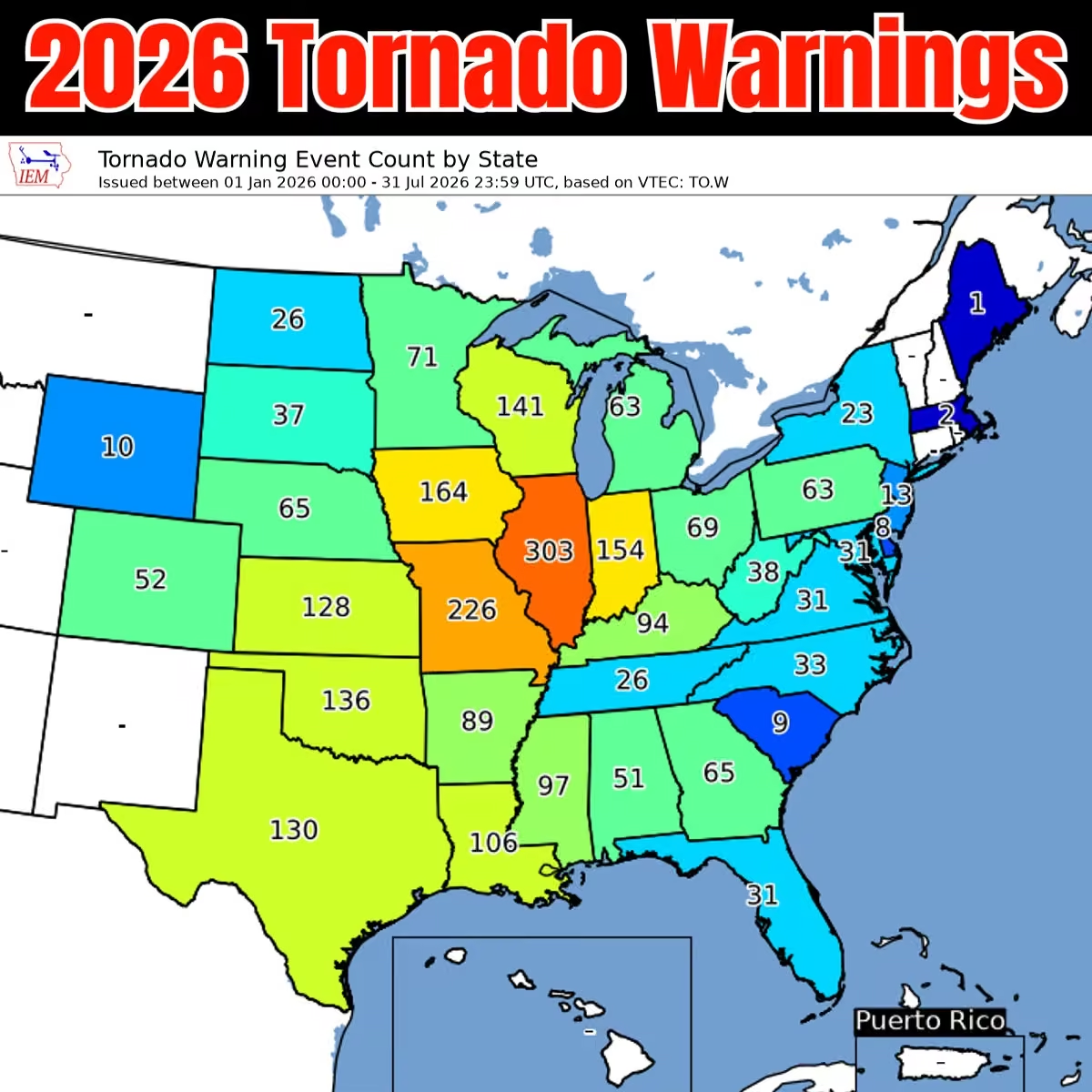 Mike's Weather Page
@tropicalupdate
07/31 Tropical Update: Nothing on the NHC radar the next 7 days. Only thing showing on models is maybe an area sliding around high pressure into the western Atlantic 2nd week of August. Some weak ensemble support right now. Figured it was worth a little tiny mention. No stress. Have a great weekend ahead! www.spaghettimodels.com
 Mike's Weather Page
@tropicalupdate
Been watching some low pressure chances into August rolling around the Bermuda high into the western Atlantic. Not a strong signal but one there to at least mention. Ensembles picking up on it a little. EURO top. Google bottom. Outside the NHC 7 day window so plenty of time to check back. Still lots of dusty dry air out there. But something the western Atlantic is a possible spot during El Nino. No worries. But you know I watch and point out potential areas... even if they end up fizzling. wwws.spaghettimodels.com
 Mike's Weather Page
@tropicalupdate
Old front sticking around bringing those rain chances through the weekend. Not a washout. But some heavy isolated totals for sure. Looks like it inched back north with northern Florida showing highest daily totals. Totals expected here. www.spaghettimodels.com
 Mike's Weather Page
@tropicalupdate
See any lightning tonight? I just did. Storms back at it drenching some areas that have already had a bunch. Current radar. General flow is SE. Couple more days of this lingering front. Some get. Some don't. Some get a lot. Some get a sprinkle. Welcome to Florida. You know. Just a normal July cold front haha. www.spaghettimodels.com
 Mike's Weather Page
@tropicalupdate
Florida drought update today. Not much changed. Few pockets of the state still need some big rains. www.spaghettimodels.com
 Mike's Weather Page
@tropicalupdate
Juice bubbling and brewing across Florida this Thursday AM. NWS showing yellow dash area fixing to get some big rains with winds/lightning. Cold front parked across the state flowing things in from the west. www.spaghettimodels.com
 Mike's Weather Page
@tropicalupdate
Mike's Weather Page
@tropicalupdate
07/30 Tropical Update: Same thing different day. Nothing cooking in the tropics. Long-range maps suggesting it could stay that way into middle August for the Atlantic. Ensembles with no real areas to chat about. Enjoy! www.spaghettimodels.com
 Mike's Weather Page
@tropicalupdate
When you see 70/80% chance of rain through the weekend what do you do? Make inside plans? Ignore? Lingering front across middle and upper Florida the next few days. Tricky forecast as always. Who gets what... and when... and how much. www.spaghettimodels.com
 Mike's Weather Page
@tropicalupdate
Thursday AM water vapor. Fascinating to look at. Northeast low over water brought all that stormy and wet weather the past few days up that way. And is connected to a long frontal line stretching through middle Florida today. High pressure builds in the middle bringing dry and even some cooler air for most in eastern US. This is July right? www.spaghettimodels.com

Mike's Weather Page reposted
 WindyCity Weather and News
@WindyCityWxMan
“There goes my roof … Aaawww crap”
Menasha Tornado up close via YouTube user @JoeSchmit
youtu.be/j3ttR3rOlrI via @YouTube
Mike's Weather Page
@tropicalupdate
NWS rainfall forecast for today Thursday. Some Gulf rains/storms out there already this AM. Forecast to build throughout the day with widespread rain expected. I know many are saying 'yea right'. Lets hope for those that want and need! www.spaghettimodels.com
 Mike's Weather Page
@tropicalupdate
Tampa Bay area. Might get some early early AM thunder waking you up tomorrow. Been watching the Gulf blob drifting maybe east before sunrise. We will sea. But rains/storms seem likely for middle state tomorrow. West central before noon starting things off. www.spaghettimodels.com
 Mike's Weather Page
@tropicalupdate
They still think they are puppies. One comes up, the other gets jealous lol. We make it work.
 Mike's Weather Page
@tropicalupdate
Crazy Florida front in July. Popping storms up north today. Same tomorrow. Some slides south. Some hangs all weekend. Bertha left some DNA in the Gulf and has been bubbling all day with not much movement. Might eventually slide east. www.spaghettimodels.com
 Mike's Weather Page
@tropicalupdate
Mike's Weather Page
@tropicalupdate
New long-range Tropics Outlook takes us into middle August. Nothing on radar as environment still doesn't show any favorable areas. Things can always change but not seeing anything right now. Enjoy! www.spaghettimodels.com
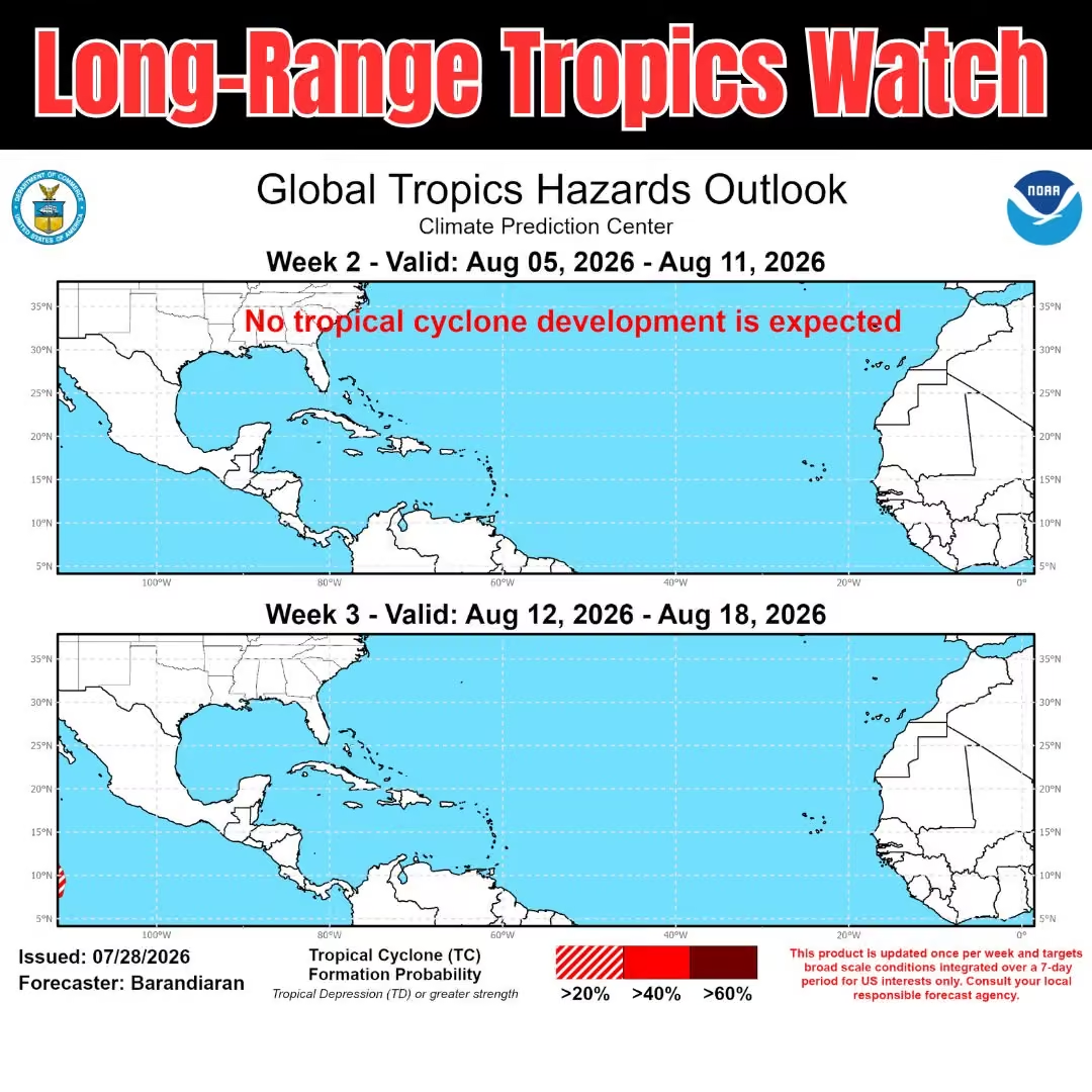 Mike's Weather Page
@tropicalupdate
Could be some feisty storms the next couple days across lower Georgia and upper Florida. Especially after mixing in daytime heating ahead of this lingering cold front. SPC outlooks here for today and tomorrow. Looking at weather patterns tomorrow. Some thunderstorms sneaking southbound into the AM and early afternoon for middle state possible. Will see if SPC bumps green down. www.spaghettimodels.com
 Mike's Weather Page
@tropicalupdate
Latest on Fausto. At one time pointed towards Hawaii, but has ended up nudging north. Only some swells expected as the storm has shriveled down to a Tropical Depression. Colder water has helped.
 Mike's Weather Page
@tropicalupdate
Mike's Weather Page
@tropicalupdate
NASCAR. Thoughts. A little rant. Then and now...
Mike's Weather Page
@tropicalupdate
7/29 Tropical Update. Read the signs. www.spaghettimodels.com
 Mike's Weather Page
@tropicalupdate
We have a lingering frontal line across the southeast this week. Yes a front. Check out these excessive rainfall maps. Nothing too extreme as of Wednesday. But a steady idea of rain potentials into the weekend. Sunday similar (not shown). Indoor plans sound good middle to upper Florida state for sure, as you show the most totals. Rays are home this weekend. Hmmmmm. www.spaghettimodels.com
 Mike's Weather Page
@tropicalupdate
Inches not sprinkles! Rain is incoming for many middle to northern parts of Florida. And could be lots of it for some. We have another front. Yes a cold front. Granted it will be 95 down from 98 but enough to bring moist air at least. Totals through the weekend here as it sits and lingers. Doesn't want to leave and go back north quite anytime soon it appears. Rain chances are up. Yes look at your APPs. This is why. www.spaghettimodels.com
 Mike's Weather Page
@tropicalupdate
Some Florida frontal action coming. Maybe BOGO style middle day middle state. Old frontal action tomorrow. New front Thursday. Things linger into the weekend middle to north state. www.spaghettimodels.com
 Mike's Weather Page
@tropicalupdate
BOGO cool fronts. What? Yep. Tomorrow another one inches south pushing rains, and storm energy southward into lower Georgia and north Florida. SPC storm potential showing. This will get tweaked tomorrow AM. www.spaghettimodels.com
 Mike's Weather Page
@tropicalupdate
It's extra extra hot today and tomorrow. A rare Exteme Heat Warning for the upper Gulf has been issued. Could see Heat Index Temperatures reaching 110°+ today, with more of the same tomorrow. Bonus summer!
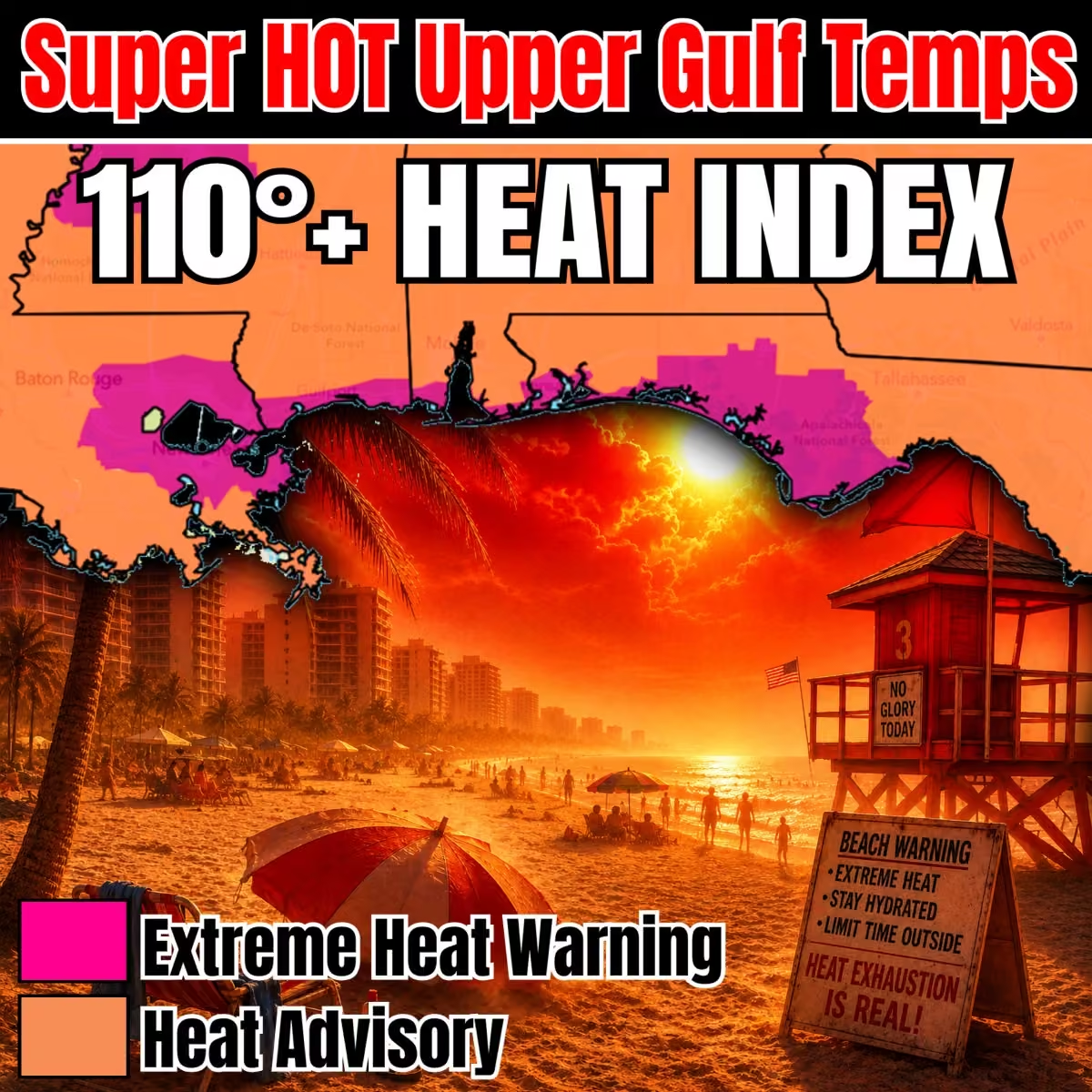 Mike's Weather Page
@tropicalupdate
Come party with us at @TBBCo Saturday night August 22nd from 5pm-8pm as we debut this year's Spaghetti Model IPA: The El Nino edition! Longo is on the can with a cool tropical vibe and real African hops copycating this year's hurricane season so far. Of course Longo and Louie will be there, and all our friends and family. Cheers and see ya there for a good time. Some FREE swag too!!!
 Mike's Weather Page
@tropicalupdate
Mike's Weather Page
@tropicalupdate
07/28 Tropical Update: Shhhhhh
 Mike's Weather Page
@tropicalupdate
Old frontal juice today lingers across the southeast US. And guess what? Another front comes in tomorrow pushing more rains and storms south. SPC showing areas to watch Wednesday with a level 2/5 already. Rainfall keeping those chances high into the weekend. Some get. Some don't. Some happy. Some mad. It's weather haha. But setup could lead to some heavy stuff falling. www.spaghettimodels.com
 Mike's Weather Page
@tropicalupdate
Some strong storms expected today Tuesday for eastern US. Tornado Outlook shows there could be a Tornado Watch to watch. www.spaghettimodels.com

Mike's Weather Page reposted
 TMJ4 News
@tmj4
Drone video shows some of the devastating destruction left in Menasha following the severe weather that hit southeast Wisconsin on Monday.
Mike's Weather Page
@tropicalupdate
Strong storms up north today. Over 1/2 million customers without power this Monday night. Illinois with the most. www.spaghettimodels.com
 Mike's Weather Page
@tropicalupdate
I guess there's an outbreak of phones stuck on SOS. Couple of ours are too errrrr. Anyone else? I blame Gilligan!!
 Mike's Weather Page
@tropicalupdate
Lingering front in July. WHAT! Yes it is true. And it will be upping those rains chances across the southeast the next several days. Actually gets a push from another one midweek. Some idea on potential flooding areas here showing through Thursday. Crystal River today got over 5"+. www.spaghettimodels.com
 Mike's Weather Page
@tropicalupdate
SPC Storm Prediction Center bumping up a large area of strong storms to watch for Tuesday. Many states completely covered in the 2/5 level. www.spaghettimodels.com
 Mike's Weather Page
@tropicalupdate
Storms rolling through Tampa late Monday morning.
Mike's Weather Page
@tropicalupdate
What the heck is this stuff?
 Mike's Weather Page
@tropicalupdate
Mike's Weather Page
@tropicalupdate
07/27 Walking and talking...
Mike's Weather Page
@tropicalupdate
07/27 Tropical Update: Don't wake the bear. He's in hibernation.
 Mike's Weather Page
@tropicalupdate
Welcome back rains! Florida with some bigger chances this week. Including today! Monday totals on top favoring west central Florida (finally). Even some flood potential to watch. Lingering front lingers all week upping the juice. www.spaghettimodels.com
 Mike's Weather Page
@tropicalupdate
Florida getting juicy this week as lingering front changes things up. Precipitable water map here for the week showing those chances. Red is moist air. Purple is very moist air. West central state for today finally showing widespread chances. www.spaghettimodels.com
Mike's Weather Page
@tropicalupdate
Hawaii watching Fausto. Latest spaghetti models on tropicaltidbits.com here showing little more bump north. Storm will be weakening in the days ahead also. Rain and surf mainly to watch. If that. www.spaghettimodels.com
 Mike's Weather Page
@tropicalupdate
Another heat wave middle US ongoing. Extreme Heat Warnings for a large chuck today. Just summer for everyone else. www.spaghettimodels.com
 Mike's Weather Page
@tropicalupdate
07/26 Tropical Update: Crickets. Enjoy. Happy Sunday! www.spaghettimodels.com
 Mike's Weather Page
@tropicalupdate
Sunday rainfall expected across the southeast. South Carolina getting juicy. Florida here and there. Some storms get spicy middle to Atlantic side again. West central getting denied... again. Maybe someone will get lucky. Maybe one. www.spaghettimodels.com
 Mike's Weather Page
@tropicalupdate
Someone tell Santa it's time to go home. Christmas is only 5 months away!
 Mike's Weather Page
@tropicalupdate
Is there any way to control how many MPH @Tesla goes over the speed limit. Hurry mode sometimes hits 22 over. The old update you could limit. I love Mad Max but who pays the speeding ticket lol.
Mike's Weather Page
@tropicalupdate
Love the aggressiveness levels now. Just wish could limit X amount of mph over speed limit.
Mike's Weather Page
@tropicalupdate
Great segment yesterday with @BobVanDillen and @foxweather talking Bertha.. They showed a bunch of my videos, from this one and years past in the same general area.. Check it out!
Mike's Weather Page
@tropicalupdate
Proud moment. Sarah completed a computer camp this week. She had to stand and give a slide presentation that was all about her. And how she wants to be a nail tech. Although the moment was special. It reminded how hard it sometimes is. For us. And for her. We can see she knows she's different. It hurts knowing that she wants to be like everyone else. To be able to drive. Go on a date. To have a long conversations. To read and write. She tries so hard. We see that. We give her all the love and support we can. And we definitely know she can see that. So at the end of the day we are all in this together. Since day one. Wouldn't change anything in the world. We are all better humans because of Sarah. And that is what life is all about. Cheers. Have a great weekend!
 Mike's Weather Page
@tropicalupdate
Upcoming weather. Hazardous Heat for most everyone. Or is that just summer? Look at Florida. See the hand? Now you can't unsee it lol. www.spaghettimodels.com
 Mike's Weather Page
@tropicalupdate
Sunday getting a little more juicy southward. Frontal line inching down. Eastern SC/GA and many in the Florida peninsula with increased rain chances. Middle and east side more. West less. Sunday totals here and flooding potential. www.spaghettimodels.com
 Mike's Weather Page
@tropicalupdate
Happy Saturday. More lingering rains from that old front linger for the Atlantic east coast. Carolinas under some heavy rain chances again. Normal Florida here or there. Sunday things get heavier as this frontal line moves south. www.spaghettimodels.com
 Mike's Weather Page
@tropicalupdate
Hawaii watching the tropics. Fausto coming close next week. Here's the latest on tropicaltidbits.com.
 Mike's Weather Page
@tropicalupdate
Florida FDOT for the win. Love these signs. They always make me smile. Which is your favorite?
 Mike's Weather Page
@tropicalupdate
Hawaii watching the tropics. Next week action close from an approaching Fausto. Should be weakening as it does but still a Tropical Storm. www.spaghettimodels.com
 Mike's Weather Page
@tropicalupdate
The final track of Big Bertha. Definitely not typical. She bounced here... there... everywhere. Started offshore of Tampa. Went south. Then north. New Orleans was on her radar for sure and a stop on Bourbon Street. Houston is where she called it quits. See ya in six years when your name will be used again. That is 2032!
 Mike's Weather Page
@tropicalupdate
Looking at the weekend Florida. Sunday rain chances bumping up a bit for the east side. Even showing some on the flood potential outlook. www.spaghettimodels.com
 Mike's Weather Page
@tropicalupdate
07/24 Tropical Update: No tropics to update. CLOSED UNTIL FURTHER NOTICE!
 Mike's Weather Page
@tropicalupdate
Apparently my brain thought it was May haha.
Mike's Weather Page
@tropicalupdate
Did you just feel an earthquake Florida??? Holy crap we just did on our ship. Literally we were on top of this earthquake just now. Everything shook. Panic definitely was in the air. Thought we lost a motor. 6.1+ magnitude reported as of now. Craziest thing ever experienced no doubt.
 Mike's Weather Page
@tropicalupdate
Looking ahead Florida. I think it is safe to say all 23.4 million of you will see rain the next 10 days. Latest NOAA blend of models here. Tropical juice will be flowing in from the Caribbean. Not all falls at once. But some isolated areas could see several inches in any random cell or rain train that sets up. The iguanas are definitely happy!
 Mike's Weather Page
@tropicalupdate
It was so great to finally meet @iCyclone today at the National Hurricane Conference. Been following for years and am a huge fan. He's the Storm Chasing legend that's for sure. Thoroughly enjoyed your presentation today and chatting afterwards.
 Mike's Weather Page
@tropicalupdate
I wish I was joking Florida. Tuesday and Wednesday mornings will be super duper chilly. Freezing feeling in the panhandle. With 30s dipping and blowing deep. A late season cold front is on the way. And a big one at that. Storms Monday likely to watch. Great way to start Spring Break. Not!!!
 Mike's Weather Page
@tropicalupdate
Florida fixing to get HOT HOT HOT on Friday. Some 90s starting to show. Saturday too. Lots of 80s. Time to enjoy the return of 'summer' for a few days for sure. Cold front coming early week though that will bring back the socks and flops. And falling iguanas.
 Mike's Weather Page
@tropicalupdate
Holy cow it's fixing to get cold. Floridians aren't built for this. Huge arctic cold front dives into the state this Saturday. Sunday AM will have record cold temps spread all across the Florida peninsula. Wind Chills in the single digits up north, with 20s to the south. No escaping it. We have to prepare. It is going to take much more than socks and flops this time around.
 Mike's Weather Page
@tropicalupdate
What an incredible rush. Big thanks to @MyFDOT_Tampa for the invite and taking me to the very top of the Sunshine Skyway Bridge! The view was unbelievable. And the ride up the elevator a little... scary lol. So much fun.


 Mike's Weather Page
@tropicalupdate
It's snowing in north Florida!
Mike's Weather Page
@tropicalupdate
Floridians aren't built for this. Latest NWS forecast temps for New Years Eve morning here. Even chillier than yesterday's numbers. 20s north and going deep. 30s/40s even deeper. 50's now for the Keys. Don't worry (be happy). It will warm up during the day. Just a couple extra hours indoors with the heat on. Just remember if you turn the heat on it might smell a little funny at first. It's an annual tradition for many. And it is OK if you have to Google ‘how to winter”.
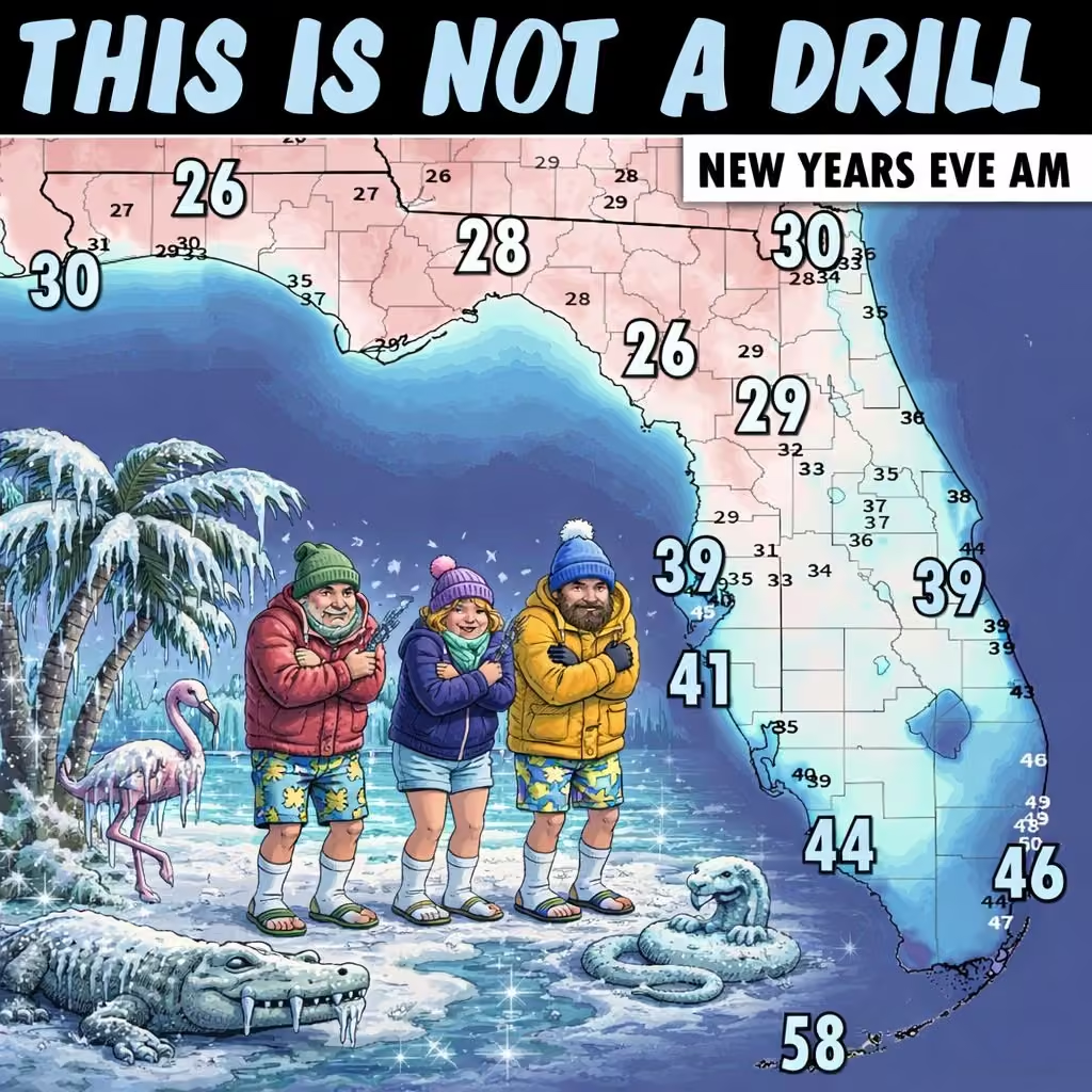 Mike's Weather Page
@tropicalupdate
No escape Florida. Freezing wind chills are coming. The last morning of 2025 will be super duper chilly. This the EURO for Wednesday AM. Some other models not as cold. But still cold. Especially by Florida standards. Will warm up during the day so just a little more time to 'chill' inside.
 Mike's Weather Page
@tropicalupdate
Latest Wednesday AM EURO/GFS ensembles on weathernerds.org. Overall trends remain. Slow drift west. Eventual front next week lifts N/NE. Caribbean/Bahamas watching the most. States keeping aware. Bermuda always watching no matter what storm this year.
 Mike's Weather Page
@tropicalupdate
Sunday early AM spaghetti models on TD#9. Confidence still strong on that turn east. spaghettimodels.com
 Mike's Weather Page
@tropicalupdate
Thursday 18z afternoon ensembles are out for Invest 94 on tropicaltidbits.com. Continues with majority heading in the north direction.
 Mike's Weather Page
@tropicalupdate
Finally got to meet @MicheleSmith32 today. We miss your tournaments but was fun watching some friends today. Cheers to no storms this year for you. @emilyboylan99
 Mike's Weather Page
@tropicalupdate
Latest EURO/GFS/CMC on tropicaltidbits.com for midweek next week. Tracks remain similar. Waiting on Hurricane models HWRF/HAFS/HMON to get a better idea on intensity chances. Invest 99 is in the Caribbean. NHC marking 90% chance to develop. Hurricane Hunters head in tomorrow. Live tonight at 8pm ET to chat. www.spaghettimodels.com
 Mike's Weather Page
@tropicalupdate
Milton is now a CAT 5 160mph Major Hurricane. Unbelievable intensification these last several hours. Historic! www.spaghettimodels.com
Mike's Weather Page
@tropicalupdate
This was what we didn't want to see this AM. Storm is getting much stronger. And wider. Current satellite. www.spaghettimodels.com
Mike's Weather Page
@tropicalupdate
Hmmmm. This is... interesting.
 Mike's Weather Page
@tropicalupdate
Dust from Africa here the next 10 days. Will help keep things quiet it looks like this next week, especially in the Caribbean. Should make it to the US even and make some nice sunsets. www.spaghettimodels.com
Mike's Weather Page
@tropicalupdate
Solar eclipse day. Latest look at possible cloud cover here.
 Mike's Weather Page
@tropicalupdate
Amazing defense from the mound last night from @emilyboylan99 here. Helping keep her high school season ERA at 0.00 in 26IP. So proud of you girl! @PHUSoftball @spcsoftball @Biggamebobby @Andy_Villamarzo @MicheleSmith32 @cindybristow @NCAASoftball @USASoftball @SportsCenter
Mike's Weather Page
@tropicalupdate
Great game today @emilyboylan99 and @coachbownetfl so proud of you and the team! In Clearwater at the @MicheleSmith32 College Showcase.
 Mike's Weather Page
@tropicalupdate
Just got to watch @emilyboylan99 pitch one of her best games at the @MicheleSmith32 showcase in Clearwater. Proud of you girl!
 Mike's Weather Page
@tropicalupdate
Flooding in Laplace, LA (permission to use please credit Mike's Weather Page).
 Texas Tech University Hurricane Research Team


