Where can you stop and smell the roses? 🌹
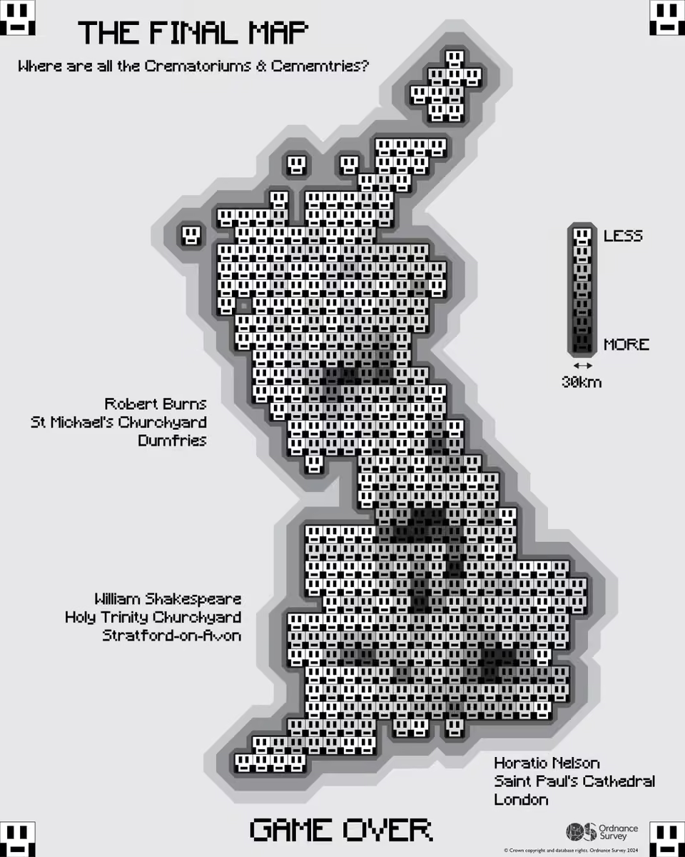
For Day 19 of the #30daymapchallenge, Rebekah Spratt hand-drew a map of some of Britain’s best-known rose gardens and hidden gems.
We absolutely love the beautiful hand-drawn details! 😍
Theme: Smell
Ordnance Survey
The Ordnance Survey (OS) is the national mapping agency for Great Britain. The agency's name indicates its original military purpose (see ordnance and surveying), which was to map Scotland in the wake of the Jacobite rising of 1745. This work was also driven by a more general and nationwide need in light of the potential threat of invasion during the Napoleonic Wars. Since 1 April 2015, the Ordnance Survey has operated as Ordnance Survey Ltd, a government-owned company, 100% in public ownership. The Ordnance Survey Board remains accountable to the Secretary of State for Science, Innovation and Technology. It was also a member of the Public Data Group. More on Wikipedia
-
Ordnance Survey
@OrdnanceSurvey

-
Ordnance Survey
@OrdnanceSurvey
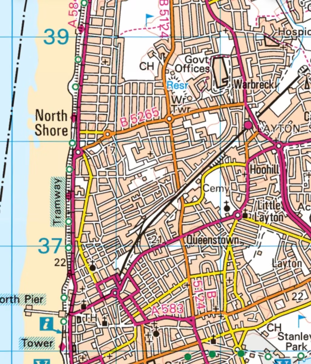
🏝️ Day 18: Null Island
Where does location data go when something goes wrong? Sometimes, 0°N, 0°E.
Known as ‘Null Island’, this fictional place can help reveal errors in geographic data when locations unexpectedly end up at these coordinates. 🗺️
#30daymapchallenge -
Ordnance Survey
@OrdnanceSurvey
🌗 Day 17: Light & Dark
A good map style does more than look good. It helps the right information stand out.
Our Geo Data Visualisation team has created a range of OS Open Zoomstack styles, including light and dark basemaps designed for data overlays. 🗺️
#30daymapchallenge -
Ordnance Survey
@OrdnanceSurvey
Day 16’s theme is Collaborative Map 🤝🗺️
Eddie Bulpitt teamed up with Saints Foundation to map Francis Benali’s 10 Peaks Challenge around Scafell Pike, which raised an incredible £54,000 for the charity.
#30daymapchallenge -
Ordnance Survey
@OrdnanceSurvey
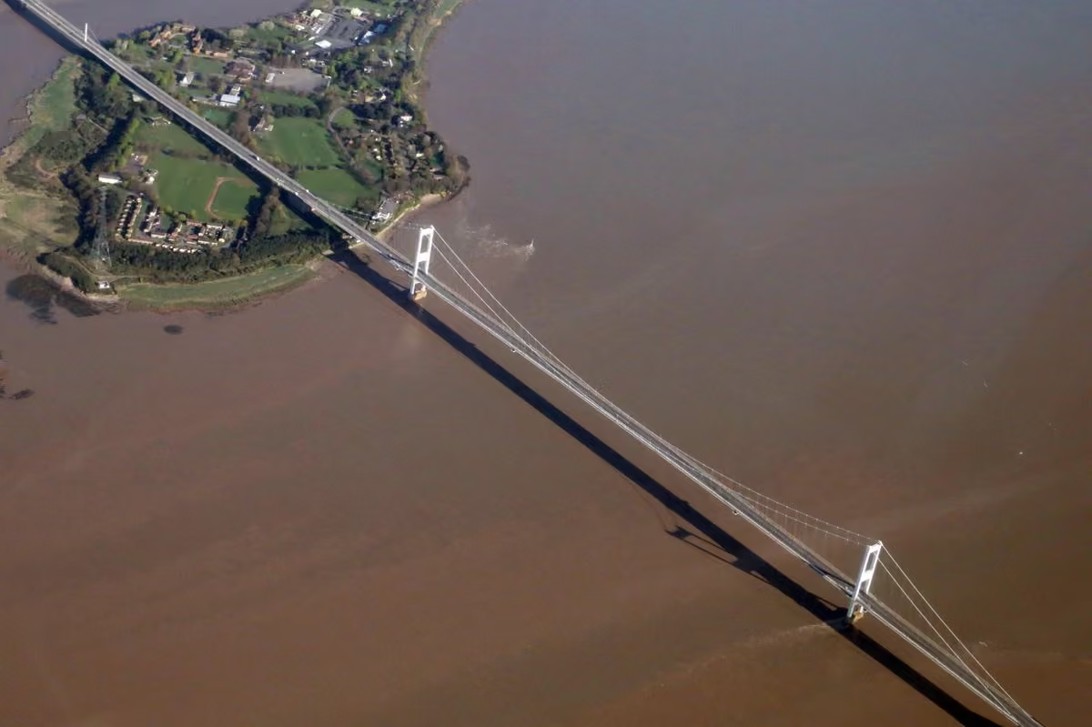
This week’s Map Monday shows a feat of Victorian engineering that’s stood here for almost 150 years. 🗺️
Think you know where we are? Drop your guess below! 👇 -
Ordnance Survey
@OrdnanceSurvey
What would Britain look like turned inside out? 🔄🗺️
For Day 15’s Inside Out theme, Jamie Young used circle inversion to flip locations across a circle running through Edinburgh, Cardiff and London, while those three cities stay exactly where they are.
#30daymapchallenge -
Ordnance Survey
@OrdnanceSurvey
What if a map was the same size as the place it represents? 🗺️
For Day 14 of the #30daymapchallenge, Emily Brawn took inspiration from Borges and Lewis Carroll, painstakingly surveying a section of sea off South Parade Pier, Portsmouth, at a 1:1 scale. -
Ordnance Survey
@OrdnanceSurvey
🧱 Lego. 🍝 Pasta. And a few pipe cleaners.
Not your typical mapping toolkit…
For Day 13 of the #30daymapchallenge, our OS Consultancy Team got crafty to explore how different datasets interact across a series of emergency scenarios. 🗺️
#30daymapchallenge -
Ordnance Survey
@OrdnanceSurvey
How do you map the power of community?
For Day 12 of the #30daymapchallenge, Paul Naylor mapped AFC Stoneham’s remarkable journey to FA Vase victory at Wembley. 🏆
A club with roots at OS stretching back to 1919! 👀 -
Ordnance Survey
@OrdnanceSurvey
Can AI map its own impact? 🤖🗺️
For Day 10 of the #30daymapchallenge, Matt Farthing tested the self-awareness of AI, asking Microsoft 365 Copilot to map global hotspots of AI power and water consumption. -
Ordnance Survey
@OrdnanceSurvey
How rural is rural? 🗺️
For Day 9 of the #30daymapchallenge, we mapped the most remote point in each ceremonial county.
🏆 Western Isles takes the top spot, with one point 79.4 km from the nearest built-up area.
Theme: Urban-Rural -
Ordnance Survey
@OrdnanceSurvey
Can you recognise this corner of Britain from a historical map? 🗺️
We’ve delved into the OS archives for Map Monday. Look closely at the coastline, settlements and transport links. Can you work out where we are?
Bonus points if you can guess when this map was published! ⏳ -
Ordnance Survey
@OrdnanceSurvey
There’s only one place in Britain where its postcode area and OS National Grid square begin with the same two letters. 📍
For Day 8 of the #30daymapchallenge, OS Surveyor Sean Kennedy, mapped the hunt for this geographical “Utopia”.
Can you find it? -
Ordnance Survey
@OrdnanceSurvey
Days 6 & 7 of the #30daymapchallenge 🗺️
🍷 A vintage-inspired map of award-winning wine producers.
⏱️ A Minecraft world surveyed and mapped by hand in just 10 minutes. -
Ordnance Survey
@OrdnanceSurvey
Day 5 of the #30daymapchallenge is all about Sight 👀❤️
With a twist on “love at first sight”, today’s map uncovers some of Britain’s most romantic street names through location data. -
Ordnance Survey
@OrdnanceSurvey
What lies beneath the Yorkshire Dales? 👀
For Day 4 of the #30daymapchallenge, Geospatial Consultant, Jess Baker, mapped its incredible concentration of caves and underground systems, including the 90 km Three Counties cave system.
Theme: Clusters 🗺️ -
Ordnance Survey
@OrdnanceSurvey
The #30daymapchallenge is underway! 🗺️
Our first three maps:
🍑 Day 1: Britain’s many “Bottoms”
➖ Day 2: 24,817 Search and Rescue operations visualised through lines
🌡️ Day 3: Heat vulnerability across Greater London
Follow along to see them all👀 -
Ordnance Survey
@OrdnanceSurvey
There’s more to this week’s Map Monday than meets the eye… 👀🗺️
This landscape was once home to a medieval settlement, traces of which can still be spotted on the map today.
Can you work out where we are? 👇 -
Ordnance Survey
@OrdnanceSurvey
🎃 It's almost Halloween!
We've already chosen our costume, and it's inspired by this mystery location... 🦇
Can you work out our costume theme and where this map extract is from? -
Ordnance Survey
@OrdnanceSurvey
This week's mystery location is famous for its connection to witches and folklore 🧙♀️
Can you tell us which village we're visiting today? -
Ordnance Survey
@OrdnanceSurvey
As the seasons change, we've picked a location that really comes into its own at this time of year. 🍂
Can you guess where this OS Maps extract is from? -
Ordnance Survey
@OrdnanceSurvey
Time your visit carefully, this week's Map Monday can only be reached when the tides allow. 🌊
Can you tell us where this map segment is showing? -
Ordnance Survey
@OrdnanceSurvey
YHA's Festival of Walking is currently underway! This Map Monday, we're highlighting a historical landmark that's welcomed walkers for centuries. 🥾
Can you tell us what famous feature this map is showing?
We'd love to know your favourite local walking route too 👇 -
Ordnance Survey
@OrdnanceSurvey
The autumn equinox takes place this week, and we've chosen a location with a name that feels perfectly suited to this time of year... 🍁
Can you tell us which village we're visiting today? -
Ordnance Survey
@OrdnanceSurvey
@heritageopenday are now underway, celebrating some of Britain's most fascinating historic places.
This week's mystery location has nearly 1,000 years of history behind it. 🏰
Can you tell us where this OS Maps extract is from?
🌿 @nationaltrust -
Ordnance Survey
@OrdnanceSurvey
The summer holidays are over, the alarm clock is back on, and many school pupils might be feeling a bit like this week's location...
Can you tell us which village this OS Maps extract shows? -
Ordnance Survey
@OrdnanceSurvey
This Scottish stretch of water has one of our favourite place names on OS Maps... 🤭 Any guesses where we are?
-
Ordnance Survey
@OrdnanceSurvey
Wildfires and extreme heat are changing the places around us. We're using location data from drones, aircraft and satellites to help government, emergency services and businesses understand climate risks and make more informed decisions. 🛰️🗺️
www.bbc.co.uk/news/articles/cp3rvd3ygqvo -
Ordnance Survey
@OrdnanceSurvey
An island with a wild side...Can you guess where this map fragment takes us? 🗺️
🐿️ Fun fact: It's one of the few places in southern England where you can still spot native red squirrels. -
Ordnance Survey
@OrdnanceSurvey
Moving home can be a stressful experience. @HMLandRegistry and OS are collaborating to ensure trusted data is accessible, transactions are smoother, and information is connected from the outset for better, faster, and less stressful property services: www.ordnancesurvey.co.uk/news/unlocking-better-less-stres…
-
Ordnance Survey
@OrdnanceSurvey
After last week's meteor shower, we're heading to a place where the stars really shine.
Can you guess the town from this map fragment? ✨ -
Ordnance Survey
@OrdnanceSurvey
This #mapmonday, can you tell us which marine nature reserve we're exploring?
Let us know your guess below! 👇 -
Ordnance Survey
@OrdnanceSurvey
This trig point stars in our new Get Real campaign, but we've hidden the place name. Can you guess where it is? 👀
Most importantly, where are you exploring this summer with OS Maps? We'd love some inspiration in the comments 🌞👇 -
Ordnance Survey
@OrdnanceSurvey
School’s out for summer 🎶 Time for family adventures to begin!
Can you guess where we’re heading first? Let us know where you're exploring this summer! ☀️ -
Ordnance Survey
@OrdnanceSurvey
Will's grandad Brian helped map Britain. Now he does too.
We heard how surveying has changed across generations at OS - from paper maps & field books to digital tools & GPS - while the mission remains the same: keeping Britain's map up to date.
📍 Full story coming soon. -
Ordnance Survey
@OrdnanceSurvey
This #mapmonday, we want to know two things...
1. Can you guess this location?
2. And more importantly, what’s the best summer hiking snack? 😋 -
Ordnance Survey
@OrdnanceSurvey
It's Monday again, you know the drill 👀 Can you guess where we’re visiting today?
-
Ordnance Survey
@OrdnanceSurvey
To wrap up National Map Reading Week, we're celebrating some of the incredible personal map collections from colleagues across Ordnance Survey 🗺️
Do you have an impressive collection of your own? Share it with us below! 👇 -
Ordnance Survey
@OrdnanceSurvey
During OS Innovation Festival, we asked the Map Men to share their top tip for anyone getting into map reading.
Knowing the difference between map scales is a fundamental navigation skill. It helps you interpret the level of detail and choose the right map for your activity. 🗺️ -
Ordnance Survey
@OrdnanceSurvey
This National Map Reading Week, we're celebrating the power of maps in education 🗺️🌍
From 2026, Digimap for Schools will reach ~1,700 more schools, giving up to 1 million additional pupils access to digital mapping and map reading skills.
Learn more: digimapforschools.edina.ac.uk -
Ordnance Survey
@OrdnanceSurvey
Why bother learning to read a map in 2026?
During this year's OS Innovation Festival, we put the question to the Map Men Mark Cooper-Jones and Jay Foreman.
Their answer is a reminder that, even in an increasingly digital world, map reading remains a valuable life skill. 🗺️ -
Ordnance Survey
@OrdnanceSurvey
It's one of our favourite times of year - National Map Reading Week! 🗺️
For this #mapmonday, how many map symbols can you see and name?
And bonus points if you can tell us where we are! 👇 -
Ordnance Survey
@OrdnanceSurvey
Their rackets are ready and our strawberries are too 🍓🎾
It all starts this week… any guesses from you? -
Ordnance Survey
@OrdnanceSurvey
This coastal spot is home to thousands of returning visitors each year. But can you guess which bird you might spot here?
These birds are nicknamed “clowns of the sea” and come back to the same burrows every year 🏡 Let us know your guess ⬇️ -
Ordnance Survey
@OrdnanceSurvey
One week to go until the OS Innovation Festival ⏳
On 24th & 25th June, we're bringing together 250+ people from across sectors for two days of hands‑on collaboration using location data.
We’re looking forward to seeing everyone there.
www.ordnancesurvey.co.uk/whats-new/innovation-festival -
Ordnance Survey
@OrdnanceSurvey
Final call 📣 Registrations for the OS Innovation Festival close tomorrow.
Sign up while you still can 👉 www.ordnancesurvey.co.uk/whats-new/innovation-festival" -
Ordnance Survey
@OrdnanceSurvey
🌊 Can you guess the coastline?
Its cliffs and coves show just how powerfully the sea shapes the landscapes we map. 🌍
On this World Oceans Day, we’re spotlighting this incredible stretch of coast and the role we all play in protecting the ocean for generations to come 💙 -
Ordnance Survey
@OrdnanceSurvey
We’re at #geobusiness today and tomorrow at ExCeL London!
If you’re attending, do come and say hi. And if not, there’s still time to join us: www.geobusinessshow.com 👋 -
Ordnance Survey
@OrdnanceSurvey
Your weekly map quiz is back! Can you name the town we are visiting today? 🍊🧸
-
Ordnance Survey
@OrdnanceSurvey
We’re excited to welcome new sponsors to the OS Innovation Festival 2026 🙌
Join us on 24th to 25th June 👉 Register now: www.ordnancesurvey.co.uk/whats-new/innovation-festival -
Ordnance Survey
@OrdnanceSurvey
The wild flower meadow outside OSHQ always looks glorious after No Mow May! 🌼
By pausing routine mowing across our sites, we’ve given space for spontaneous wildflowers to emerge, supported essential pollinators, and helped boost local biodiversity in a simple way. -
Ordnance Survey
@OrdnanceSurvey
Hmmm... lots of contour lines and trees 🤔 Do you know the Loch this map segment is near?
-
Ordnance Survey
@OrdnanceSurvey
A cyclist's haven - but do you know where? 🚴♀️
-
Ordnance Survey
@OrdnanceSurvey
Are you attending GeoPlace 2026?
Join the speaker session 'The Street Gazetteer, unlocking benefits to highways authorities' at 2pm in the Premiership Suite.
OS will be demonstrating a pedestrian routing prototype and how it can support active travel: www.geoplace.co.uk/new-sessions/the-street-gazetteer-unlo… -
Ordnance Survey reposted
Groundsure
@Groundsure
We look forward to attending @UKREiiF 2026 next week. If you wish to meet up with our lovely team, do get in touch! We are proud to host our very own fringe event on the 20th May. Attendees will have the chance to hear from our guest speaker, Pam Whitham from @OrdnanceSurvey 🎙️
-
Ordnance Survey
@OrdnanceSurvey
We’re heading to GeoBusiness 2026!
Join us as we showcase the future of Britain’s geospatial infrastructure – from OS Net & PNT resilience to NUAR and the OS NGD.
🎤 Packed speaker programme and roundtable on the future of BNG & ODN
📍 Register now: www.geobusinessshow.com -
Ordnance Survey
@OrdnanceSurvey
Egbe Manners shares what to expect from the "See it coming" sprint at the OS Innovation Festival.
If you’re interested in collaborating across organisations and shaping practical ideas, this sprint is for you.
Find out more and sign up here: www.ordnancesurvey.co.uk/whats-new/innovation-festival -
Ordnance Survey
@OrdnanceSurvey
This #mapmonday, can you tell us what connects these UK villages? 🌿✨
-
Ordnance Survey reposted
RGS-IBG Schools
@RGS_IBGschools
Looking to make the most of Digimap for Schools with your students?
In partnership with @OrdnanceSurvey, this short session will explore the thematic overlays and historical data functionality within Digimap for Schools.
Book now 👉www.rgs.org/events/upcoming-events/digimap-for-schools-ov… -
Ordnance Survey reposted
Association for Geographic Information
@GeoCommunity
What a brilliant launch for the AGI South Coast Network hosted by @OrdnanceSurvey at Explorer House
Bringing together geospatial professionals from across the region for an evening of insight and networking
🔗Read more www.agi.org.uk/a-brilliant-launch-for-the-agi-south-coast… -
Ordnance Survey
@OrdnanceSurvey
Join us at the OS Innovation Festival on 24th - 25th June and take part in our innovation sprints where you’ll explore challenges, test ideas and build practical solutions across a choice of sectors.
You can explore these here: www.ordnancesurvey.co.uk/whats-new/innovation-festival -
Ordnance Survey
@OrdnanceSurvey
Join us at Utility Week Live at stand C2. Meet partners Experian, AMT-SYBEX & Integrated Skills Ltd and learn how NUAR is improving underground asset management www.utilityweeklive.co.uk
-
Ordnance Survey
@OrdnanceSurvey
When emergencies happen on roads, rivers or open land, knowing exactly where someone is can save lives. 🚑
The OS Emergency Services Gazetteer helps identify places like bridges and junctions so help reaches the right place faster: www.ordnancesurvey.co.uk/products/os-emergency-services-g… -
Ordnance Survey reposted
RGS-IBG Schools
@RGS_IBGschools
Looking to explore new ways to map fieldwork?
In partnership with @OrdnanceSurvey, this session will show both new and experienced users of Digimap for Schools how to map local fieldwork and fieldtrip locations - plus handy apps to support your process 👇
www.rgs.org/events/upcoming-events/digimap-for-schools-ks… -
Ordnance Survey reposted
Pets Magazine
@Pets_Mag
We’re delighted to welcome @OrdnanceSurvey as sponsor of Field Notes, our brand new countryside column
First up is photographer Gerry Slade and his Dogs of Great Britain exhibition in aid of @Heropawsuk and the Children’s Air Ambulance.
#countryside #dogwalks -
Ordnance Survey
@OrdnanceSurvey
Heading to the Esri Conference?
Come and meet OS experts in person, get up to speed with our latest data release, and see how it can work for you. #esriukac @esriuk -
Ordnance Survey
@OrdnanceSurvey
A big thank you to the sponsors supporting OS Innovation Festival 2026!
Their support helps bring together people, ideas and collaboration focused on real challenges around place, data and impact.
Sign up to join us next month: www.ordnancesurvey.co.uk/whats-new/innovation-festival #osinnovationfest -
Ordnance Survey
@OrdnanceSurvey
A forest fit for a lightsaber duel ⚔️🔵🔴 This #mapmonday, can you tell us where the real‑life Takodana is?
Happy Star Wars Day! ✨ -
Ordnance Survey
@OrdnanceSurvey
When every second counts, knowing exactly which bridge is involved is critical. 🚨
New third‑party bridge information adds recognised names and identifiers for bridges across GB, helping emergency services confirm locations faster.
Explore the data: www.ordnancesurvey.co.uk/products/os-ngd -
Ordnance Survey
@OrdnanceSurvey
From the school run to the daily commute, bus and cycle infrastructure shapes safer, more sustainable journeys. 🚍🚲
Bus and cycle lane data is now available with full GB coverage, showing where road space is designated for buses and cyclists: www.ordnancesurvey.co.uk/products/os-ngd -
Ordnance Survey
@OrdnanceSurvey
From technology and maps to leadership and the natural world, OS Innovation Festival brings together voices exploring how we understand place and drive change. 💡
Save your spot for the Innovation Festival: www.ordnancesurvey.co.uk/whats-new/innovation-festival #osinnovationfest -
Ordnance Survey
@OrdnanceSurvey
Two months to go until the OS Innovation Festival! ⏳
This summer, innovators from across the public and private sectors will come together to explore how location data can unlock new ideas and opportunities.
Save your spot and be part of it: www.ordnancesurvey.co.uk/whats-new/innovation-festival -
Ordnance Survey
@OrdnanceSurvey
Better postcode data is here. 📨
New postcode data delivers better postcode geography for Great Britain and Northern Ireland, including postcode unit areas and points for GB and postcode points for NI.
Discover the data on the OS Data Hub: www.ordnancesurvey.co.uk/products/os-ngd -
Ordnance Survey reposted
RGS-IBG Schools
@RGS_IBGschools
Want to empower your students to use Digimap for Schools with confidence?
In partnership with @OrdnanceSurvey, this short session will explore data collection and tables, helping you to support students as they carry out geographical enquiries.
Book now👉www.rgs.org/events/upcoming-events/digimap-for-schools-da… -
Ordnance Survey
@OrdnanceSurvey
The trig pillar where it all began 🧭
Cold Ashby kicked off Britain’s retriangulation in 1936… But do you know where it ended? 👀 -
Ordnance Survey
@OrdnanceSurvey
Registrations are open for the OS Innovation Festival! 🎉
Join people from across the public and private sectors for two days of hands-on innovation, collaboration and fresh thinking using location data.
Register now: www.ordnancesurvey.co.uk/whats-new/innovation-festival -
Ordnance Survey
@OrdnanceSurvey
Every child deserves the chance to explore the world through maps. 🗺️
From 2026, free access to Digimap for Schools is expanding to reach more schools in areas of greatest need across GB - supporting geography and digital skills in the classroom: digimapforschools.edina.ac.uk -
Ordnance Survey
@OrdnanceSurvey
These 4 locations have a colourful connection this #mapmonday. But can you tell us where they all are? 🌈🗺️
-
Ordnance Survey
@OrdnanceSurvey
New updates to the OS Emergency Services Gazetteer are now available:
🔵 Slipways
🔵 Weirs
🔵 Third‑party bridge information
Supporting incident response and reporting by expanding the range of locations included in OS ESG. Discover via the OS Data Hub: www.ordnancesurvey.co.uk/products/os-emergency-services-g… -
Ordnance Survey
@OrdnanceSurvey
Growing communities and climate change are putting pressure on water supply. 💧
Location data helps water companies understand demand, plan new infrastructure and protect services people rely on every day: www.ordnancesurvey.co.uk/insights/water-industry-meeting-… -
Ordnance Survey
@OrdnanceSurvey
Eggardon Hill in Dorset is looking egg‑stra special on the map this Easter Monday 🥚
Which Easter‑themed locations do you love? -
Ordnance Survey
@OrdnanceSurvey
The good eggs in our cartography team have been doing some very eggxtra complex analysis for us in the lead up to Easter...
According to their research 1,636,000 mini eggs would fit around the circumference of the Isle of Eigg. To put that to scale, that's 654,000 Creme eggs 🥚 -
Ordnance Survey
@OrdnanceSurvey
From local high streets to shopping centres, retail shapes everyday life. 🛍️
We’re releasing new retail areas data to show where retail activity happens across the nation.
Discover the data on the OS Data Hub: www.ordnancesurvey.co.uk/products/os-ngd -
Ordnance Survey
@OrdnanceSurvey
Today we’re thrilled to announce a trial of Adaptive Grid North - a rotated Grid North to future‑proof OS maps. To try it now, simply tilt your map (or your head).
Dr Polly Axis says this may cut navigational ambiguity by 0.00003%. If you get lost, it’s now science-approved!
Ordnance Survey
@OrdnanceSurvey
April Fools! 👀 Did we get you?
-
Ordnance Survey
@OrdnanceSurvey
Happy #mapmonday! Do you have a favourite pub walk?
-
Ordnance Survey
@OrdnanceSurvey
Ever had patchy signal at home or slow broadband on your street? 📶
Accurate location data helps telecoms providers spot underserved areas and target upgrades where people actually need them: www.ordnancesurvey.co.uk/insights/telecoms-customer-satis… -
Ordnance Survey
@OrdnanceSurvey
Introducing the latest updates to the OS National Geographic Database 🎉
🔵 Retail areas
🔵 GB Postcode unit areas and points
🔵 NI Postcode points
🔵 Bus & Cycle lanes - full GB coverage
🔵 Third‑party bridge information
Discover the new data: www.ordnancesurvey.co.uk/products/os-ngd -
Ordnance Survey
@OrdnanceSurvey
Flooding can leave people cut off from work, school and essential services 🌊
New analysis, using @EnvAgency and OS NGD data, shows how vulnerable key roads and rail routes across England are to extreme weather - and what that means for communities: www.ordnancesurvey.co.uk/insights/flooding-threatens-to-c… -
Ordnance Survey
@OrdnanceSurvey
We’re here at @BAPCOEvent and already having lots of great conversations! 🤝
Come and see us in the Ordnance Survey GeoZone to talk about MAIT and connect with our experts and partners supporting emergency services and defence. #bapco2026 -
Ordnance Survey
@OrdnanceSurvey
The state of the buildings around us affects safety, services and everyday life. 🏢
OS NGD Buildings shows the physical condition and status of buildings - supporting safer planning and emergency response.
Explore OS NGD: www.ordnancesurvey.co.uk/products/os-ngd -
Ordnance Survey
@OrdnanceSurvey
When maps are your day job, some never quite leave you. 🗺️ We’re back with part two of your favourite map makers’ favourite maps - and the stories behind why they stood out.
Do you have a favourite map?This media couldn't be displayed. See it on the original post. -
Ordnance Survey
@OrdnanceSurvey
We asked OS Partners what’s exciting them most about OS data right now.
From NUAR and OS NGD to the evolution of our basemaps, the message is clear: location data is unlocking smarter ideas, deeper insight and better decision-making across sectors. -
Ordnance Survey
@OrdnanceSurvey
Monday morning feels... 😴
Do you know the ceremonial county these sleepy spots are in? -
Ordnance Survey
@OrdnanceSurvey
Heading to #bapco2026? 👋 Join us at the @BAPCOEvent from 25-26 March in Coventry!
Connect with OS and our partners in the Ordnance Survey GeoZone to learn how we support emergency services and defence.
Register here: www.bapco-show.co.uk -
Ordnance Survey
@OrdnanceSurvey
What are your memories of learning geography at school? 🗺️
Digital geography skills are just as vital today. That’s why OS is expanding free access to Digimap for Schools, supporting teachers and pupils across England, Scotland and Wales.
Learn more: www.ordnancesurvey.co.uk/news/new-digimap-for-schools-offer -
Ordnance Survey
@OrdnanceSurvey
Do you know the location and symbols in today's #mapmonday ?
-
Ordnance Survey
@OrdnanceSurvey
When we say Send it, this is where we mean. Do you know the name of the river that flows through this town?
-
Ordnance Survey
@OrdnanceSurvey
Building PropTech with land & property data? 🏘️
Move faster with £20k equity‑free funding, mentoring and access to OS & @HMLandRegistry datasets.
Spring 2026 Geovation Accelerator applications close on 28 Feb: geovation.grantplatform.com -
Ordnance Survey
@OrdnanceSurvey
From pavements and car parks, to green spaces people enjoy every day - learn how OS NGD data is helping local authorities make smarter decisions for the places communities rely on: www.ordnancesurvey.co.uk/blog/more-efficient-land-managem…
-
Ordnance Survey
@OrdnanceSurvey
We asked your favourite map makers about their favourite maps 🗺️ Is there a map or geodataviz that's been memorable for you?
This media couldn't be displayed. See it on the original post. -
Ordnance Survey
@OrdnanceSurvey
Let's test our geography knowledge this #mapmonday, can you name the types of water features shown here?
-
Ordnance Survey
@OrdnanceSurvey
Love is in the air… and on the map! 💘🗺️
From the whimsical Lovers Lane to the sweetly named Honeypot Meadow and Darling Road, we’ve tracked down some of Great Britain’s most romantic place names: www.ordnancesurvey.co.uk/blog/romantic-street-names -
Ordnance Survey
@OrdnanceSurvey
Britain’s coastline is constantly on the move. For the people who live, work or spend time near the sea, those changes can shape daily life. 🌊
Learn how location data can support better planning for the future of our coast: www.ordnancesurvey.co.uk/news/new-continuous-tidelines-data -
Ordnance Survey
@OrdnanceSurvey
From 2026, more schools and more pupils across GB will gain free access to digital geography tools. ✏️🌍
Enabling more teachers to be supported with high quality digital mapping in their classrooms - where it can make the biggest difference: www.ordnancesurvey.co.uk/education/gis-schools/digimap -
Ordnance Survey
@OrdnanceSurvey
Behind every dig site is a team relying on accurate information to stay safe and keep the country moving.🛠️
NUAR’s next steps focus on clearer data and instant notifications so teams can dig with confidence: www.ordnancesurvey.co.uk/blog/gds-update-on-nuar -
Ordnance Survey
@OrdnanceSurvey
Have you ever had a home or office that feels chilly no matter how high you turn up the heating? 🥶
Often, it’s not about just usage - it’s about how the home is built, where it’s located, and the conditions around it: www.ordnancesurvey.co.uk/insights/how-location-data-can-h… -
Ordnance Survey
@OrdnanceSurvey
It’s World Wetlands Day 💦 Wetlands cover just 6% of Earth but support 40% of species.
Explore and show your nearest RSPB soggy patch some love:
Scotland: Loch Leven 🦢
Cymru: Cors Ddyga 🦅
England: Ham Wall 🌾
📍Find your nearest wetland via the blue bird symbol on OS Maps. -
Ordnance Survey
@OrdnanceSurvey
Free digital mapping resources are reaching over a million pupils in areas of greatest need across Great Britain. 🗺️
Through Digimap for Schools, OS is supporting teachers to inspire future geographers and build digital skills.
Learn more: www.ordnancesurvey.co.uk/news/new-digimap-for-schools-offer -
Ordnance Survey
@OrdnanceSurvey
Innovation Festival 2026 will bring together innovators from government, industry and academia for two days of collaboration and hands-on problem solving using location data.
📅 24 - 25 June 2026
📍 Southampton
Register your interest: www.ordnancesurvey.co.uk/whats-new/innovation-festival -
Ordnance Survey reposted
HPM Magazine
@HpmMag
.@OrdnanceSurvey has conducted an analysis of 23.6 million homes across Britain to identify which are the most and least efficient properties to heat.
www.hpmmag.com/news/ordnance-survey-identifies-hard-to-he…
#heating #plumbing #buildings #construction -
Ordnance Survey
@OrdnanceSurvey
Do you know where this Tongue of Britain is? 👅😛
-
Ordnance Survey
@OrdnanceSurvey
Why might your home be colder than the one down the road? 🏠❄️
We analysed 23.6M homes across GB to understand how building age, materials and layout affect heat retention.
This insight helps show where energy-efficiency upgrades could matter most: www.ordnancesurvey.co.uk/insights/how-location-data-can-h… -
Ordnance Survey
@OrdnanceSurvey
Last night’s solar storm made the Northern Lights visible in parts of the UK 🌌
Solar activity like this can also influence satellite signals used for navigation and positioning on Earth.
Learn how solar storms interact with satellite navigation: www.ordnancesurvey.co.uk/insights/ordnance-surveys-early-… -
Ordnance Survey
@OrdnanceSurvey
🐤Birds Rock. What is your favourite British bird and do you know where today's #mapmonday is?
-
Ordnance Survey
@OrdnanceSurvey
Are you using OS VectorMap Local? We want your feedback!
Your input helps shape the next update. Take our quick survey by 31 January: forms.cloud.microsoft/pages/responsepage.aspx?id=LXSIeUPF… -
Ordnance Survey
@OrdnanceSurvey
Let's lighten the load this Monday with some mappy jokes! Drop your best LOL‑worthy geography gags in the comments and we’ll rate them out of 10 😏🥁
📍Bonus points if you actually know where Lollover Hill is - and no, “on a map” doesn’t count. -
Ordnance Survey
@OrdnanceSurvey
What’s next for geospatial technology in 2026?
Easier access to location insight, smarter use of AI, and humans staying firmly in the loop. CTO Manish Jethwa shares his predictions: www.ordnancesurvey.co.uk/insights/manish-jethwa-predictio… -
Ordnance Survey reposted
The CJS Team
@CountrysideJobs
Ever turned back because a path was blocked, flooded or overgrown? 🌧️🌳
@OrdnanceSurvey’s new Community Alerts on OS Maps let walkers, hikers & cyclists report real-time footpath issues – and see problems ahead before they arrive.
Discover how it works: c-js.uk/3YrNjlb -
Ordnance Survey
@OrdnanceSurvey
POV: First day back at work after Christmas 💀 For this #mapmonday tell us where you’d rather be instead of at work! 👇
-
Ordnance Survey
@OrdnanceSurvey
What will shape UK infrastructure in 2026? Smarter planning, better use of data and a deeper understanding of place.
Chris Wilton’s predictions explore what's next for energy, data centres and local infrastructure: www.ordnancesurvey.co.uk/insights/chris-wilton-prediction… -
Ordnance Survey
@OrdnanceSurvey
The crimbo-limbo is blurring the days together and we may have consumed too much cheese but it is time for the last #mapmonday of 2026 🍷🧀
Tell us the grid co-ordinate of Cheese Hill... and what type of cheese you think it is made of 😆 -
Ordnance Survey
@OrdnanceSurvey
Explore a fresh walk with one of our favourite festive routes across Britain: osmaps.com/discover/guides/christmas-walk-ideas/ ⛄
-
Ordnance Survey
@OrdnanceSurvey
Mappy Christmas! 🗺️🎄⭐
-
Ordnance Survey
@OrdnanceSurvey
Santa has a lot of rooftops to cover on Christmas Eve. 🎅🛷
From flat roofs to thatched ones, we mapped his journey across Great Britain to help plan safe landings and smooth stops along the way. -
Ordnance Survey
@OrdnanceSurvey
Britain is full of festive street names - and not just at Christmas. 🎄
From Noel Road and Christmas Lane to North Pole Road and Santa Claus Drive, Christmas cheer can be found right across the map. 🎅 -
Ordnance Survey
@OrdnanceSurvey
#mapmonday Festive Edition ✨ Can you guess the connection between these places?
We bet lots of you have been to watch one of these in the last month! -
Ordnance Survey
@OrdnanceSurvey
From mapping GB to championing wellbeing - Martin has used his lived experience to support others at OS as a Mental Health Champion, from webinars on burnout & change to everyday check‑ins: mentalhealth-uk.org/about-us/stories/martins-story/ 🤝
-
Ordnance Survey
@OrdnanceSurvey
What tasty, festive editions would you add to this map? 🍽️
-
Ordnance Survey
@OrdnanceSurvey
Help us improve OS VectorMap Local!
Share your thoughts in our quick survey - your input could shape the next update: forms.cloud.microsoft/pages/responsepage.aspx?id=LXSIeUPF… -
Ordnance Survey
@OrdnanceSurvey
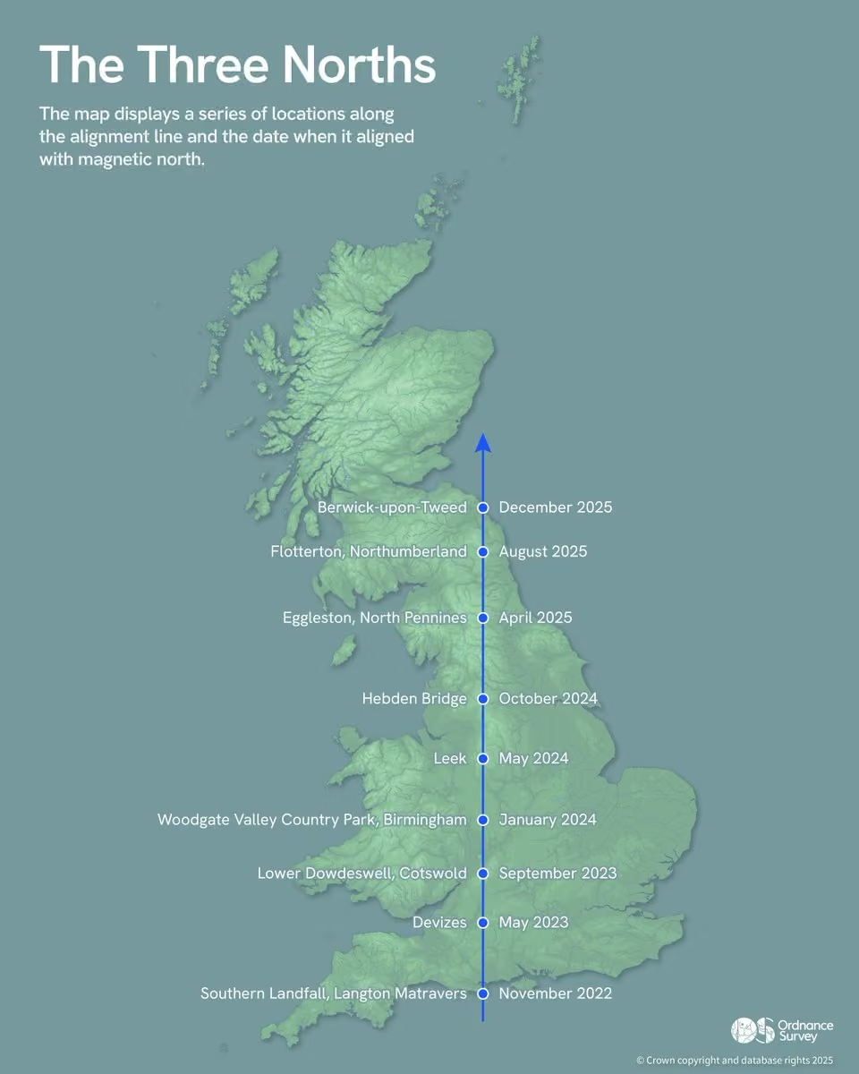
The rare alignment of the three norths is leaving England. 🧭
On 13 December, true north, magnetic north and grid north stop aligning at Berwick-upon-Tweed, marking a major mapping milestone.
Next landfall will be in Scotland in 2026: www.ordnancesurvey.co.uk/news/three-norths-departing-england -
Ordnance Survey
@OrdnanceSurvey
The 12 days of Christmas... but make it mappy 🗺️✨ Do you have a favourite festive place?
-
Ordnance Survey reposted
UKAuthority
@UKAuthority
@OrdnanceSurvey launches new tidelines dataset www.ukauthority.com/articles/ordnance-survey-launches-new… #geospatial #locationdata
-
Ordnance Survey
@OrdnanceSurvey
Your outie likes looking at maps. They trust lines more than feelings.
What other activities would your outie enjoy doing? Do you reckon your outie know where today's #mapmonday is? -
Ordnance Survey
@OrdnanceSurvey
Every map begins with a blank space and a question - what story does this place need to tell? 💡
Layers of location data - buildings, roads, water, height - get shaped and simplified until the pattern becomes clear.
A map isn’t made by detail - it’s made by decisions. -
Ordnance Survey
@OrdnanceSurvey
Dogs + trig pillars = pure adventure! 🐶
-
Ordnance Survey
@OrdnanceSurvey
Another amazing year of the #30daymapchallenge! Our colleagues explored new techniques and showcased what's possible when creativity meets data 🗺️
See the full collection of OS entries in our map gallery: labs.os.uk/public/30-day-map-challenge/2025/ -
Ordnance Survey
@OrdnanceSurvey
A major NUAR milestone as @WeAreOpenreach adds 550,000+ km of network data to the platform, taking NUAR to 3.2 million km of mapped underground assets and roughly 80% of known buried infrastructure.
This update strengthens accuracy, efficiency and confidence on site.
Ordnance Survey
@OrdnanceSurvey
Read more: www.ordnancesurvey.co.uk/news/openreach-joins-nuar
If you would like to learn more about NUAR, please contact support@nuar.uk. -
Ordnance Survey
@OrdnanceSurvey
Turn sites into opportunities with enhanced OS NGD Land Use data. 🌿Revealing the current status of topographic features across GB, discover how the latest OS NGD data helps you drive government policies, target regeneration and plan green infrastructure: www.ordnancesurvey.co.uk/products/os-data-hub
-
Ordnance Survey
@OrdnanceSurvey
Hedgerows do more than mark boundaries - they prevent soil erosion and support wildlife. 🌿
For Day 27 of #30daymapchallenge - Boundaries, Production Consultant Thomas Bristow maps hedgerow density across GB using OS NGD Field Boundaries & Local Authority data. -
Ordnance Survey
@OrdnanceSurvey
Ever wondered where ‘Ordnance’ appears on the map? 🗺️
Production Consultant Harry Searles explores every feature in OS data containing the word ‘Ordnance’, highlighting historic associations and points of interest.
For Day 24 of the #30daymapchallenge - Places and their names.
Ordnance Survey
@OrdnanceSurvey
*Copy correction: historically associated
-
Ordnance Survey
@OrdnanceSurvey
For Day 30 of #30daymapchallenge - Makeover, Geospatial Analyst Hannah Brooks reveals the dramatic transformation of a map through styling choices.
Each step shows how geo data visualisation turns raw data into a polished, compelling design. 🎨 -
Ordnance Survey
@OrdnanceSurvey
Ever wondered how near you are to a truly prominent hill? 🗻
Field Surveyor Robert Finch maps England’s 10km grid squares by proximity to the nearest Marilyn (150m prominence), using OS National Grid and hill data for Day 29 of the #30daymapchallenge - Raster. -
Ordnance Survey
@OrdnanceSurvey
By blending craft and cartography, Geospatial Consultant Guy Heathcote uses seamless raster textures in QGIS to style OS NGD vector data, then frames it in Blender.
London’s Wood Green takes on a distinctive look for Day 29 of #30daymapchallenge - Raster. -
Ordnance Survey
@OrdnanceSurvey
For Day 28 of #30daymapchallenge - Black, Senior Production Manager Tom Moir transforms Ben Nevis, Snowdon & Scafell Pike into sculptural forms using data from OS Terrain 50 & Terrain 5.
Contours on black reveal the beauty of Britain’s highest peaks. ⛰️ -
Ordnance Survey
@OrdnanceSurvey
For Day 27 of the #30daymapchallenge - Boundaries, Data Scientist Tom Peterken maps embassy locations to reveal where countries “border” each other in the capital.
Using OS NGD Address, Sites and Buildings data. -
Ordnance Survey
@OrdnanceSurvey
For Day 26 of the #30daymapchallenge - Transport, Field Surveyor Sophie Boyadjieva maps the introduction of trolleybuses across Europe, showing when each country embraced this electric mode of transport.
-
Ordnance Survey
@OrdnanceSurvey
Where are London’s busiest Underground stations? 🚇
Data Management Analyst Jacob Kilby maps annualised entry/exit figures for 2024 using @TfL Open Data, with proportional symbols showing the hotspots across London.
For Day 26 of the #30daymapchallenge - Transport. -
Ordnance Survey
@OrdnanceSurvey
Great Britain as a board game! 🎲
Geospatial Consultant James Armstrong recreates the map using a hexagonal grid inspired by strategy games. Navigate the country, aim for the fewest turns and score big on sustainability!
For Day 25 of the #30daymapchallenge - Hexagons. -
Ordnance Survey
@OrdnanceSurvey
Thank you to everyone who attended our #govgeo25 event in Llandudno with @WelshGovernment!
Special thanks to @Keep_Wales_Tidy and @torfaencouncil for their insightful stories of how location data is helping them achieve great things. -
Ordnance Survey
@OrdnanceSurvey
Location data powers Britain’s connectivity. This is how OS data helps telecoms plan smarter, reduce costs and deliver reliable service to every community: www.ordnancesurvey.co.uk/insights/location-data-bridging-…
-
Ordnance Survey
@OrdnanceSurvey
Paris, Texas… and Paris, France. 🌍
Software Engineer Dan Whitford maps North and South American cities that share names with places in Europe - a fascinating look at naming patterns across continents.
For Day 24 of the #30daymapchallenge - Places and their names. -
Ordnance Survey
@OrdnanceSurvey
Field Surveyor Alicja Kalnina brings Welsh landscapes to life in felt for Day 23 of the #30daymapchallenge - Process. 🗺️
Inspired by rural roads, rolling hills and the heritage of Welsh wool, this tactile map celebrates elevation in a whole new way. -
Ordnance Survey
@OrdnanceSurvey
From thousands of trig points to just over 100 GNSS stations - technology has transformed OS’s control network. 📡
Senior Production Manager Tom Moir visualises this evolution for Day 23 of the #30daymapchallenge - Process. -
Ordnance Survey
@OrdnanceSurvey
Sometimes the best maps need no explanation – just pure Earth 'data'. 🌍
Senior Geospatial Consultant Danny Hyam keeps it simple for Day 22 of the #30daymapchallenge - Data (Natural Earth). -
Ordnance Survey
@OrdnanceSurvey
Geospatial Consultant Guy Heathcote takes us on an iconic lunchtime quest through Adanac Park! 🥐☕
This playful map uses 3D models as icons in a 2D world, showing the essential stops near OS HQ.
For Day 21 of the #30daymapchallenge - Icons. -
Ordnance Survey
@OrdnanceSurvey
Data Scientist Tom Peterken maps UK fishing ports by fleet size using @The_MMO vessel lists, OS tidelines and @UKHO boundaries.
Territorial waters are shaded by the nearest port - built in Python.
For Day 20 of the #30daymapchallenge - Water🎣 -
Ordnance Survey
@OrdnanceSurvey
Surveyor Tim Henry explores the mysticism of Great Britain’s rivers for Day 20 of the #30daymapchallenge - Water. 💧
This map highlights legendary waterways and the folklore that flows through them, using OS Open Rivers, Boundary Line and GB Overview Maps. -
Ordnance Survey
@OrdnanceSurvey
For Day 20 of the #30daymapchallenge - Water, Production Manager Matt Farthing maps the 10 most extensive river catchments in GB, based on cumulative lengths of rivers and tributaries using OS Open Rivers data.
Which one of these is the closest to you? 🌊 -
Ordnance Survey
@OrdnanceSurvey
Another fantastic #govgeo25 event with @WelshGovernment in Cardiff!
Today’s agenda featured inspiring customer stories from our PSGA community in Wales, an OS NGD workshop, networking opportunities, and more.
Thank you to everyone who joined us - see you in Llandudno next week! -
Ordnance Survey reposted
Department for Science, Innovation and Technology
@SciTechgovuk
Speaking @at_RIN, Lord Vallance announced £155 million to safeguard critical sectors.
💪 This investment will strengthen the resilience of our Positioning, Navigation and Timing (PNT) services, which support everything from Sat Navs and mobile phones to the stock market. -
Ordnance Survey reposted
-
Ordnance Survey
@OrdnanceSurvey
Can you spot your local cinema on the map? 🎥
Geospatial Consultant Jess Baker maps every cinema in Great Britain using OS NGD Land Use Features - Sites.
For Day 19 of the #30daymapchallenge - Projections. -
Ordnance Survey
@OrdnanceSurvey
The National Highways Network Model, developed by @NationalHways and powered by OS data, could change the way we travel on England’s roads.
Discover how the model will lead to safer and more efficient journeys 👇This media couldn't be displayed. See it on the original post.
Ordnance Survey
@OrdnanceSurvey
Learn more about The Network Model: www.ordnancesurvey.co.uk/news/new-motorway-and-a-road-mod…
-
Ordnance Survey reposted
Cheryl Coombes
@CherylCoombes1
Happy Mappy GIS day everyone. To the lovely people at @OrdnanceSurvey and @cadcorp for making our work come to life 💜#gisday2025
-
Ordnance Survey
@OrdnanceSurvey
For Day 18 of the #30daymapchallenge - Out of This World, Geospatial Analyst Hannah Brooks maps a Victorian London that never stopped expanding, creating a fantastical map full of eccentric places.
-
Ordnance Survey
@OrdnanceSurvey
Graduate Rebekah Spratt maps the northern and southern night skies for Day 18 of the #30daymapchallenge - Out of This World.
Using colours from Van Gogh’s Starry Night, these celestial charts bring art and astronomy together. 🌌 -
Ordnance Survey
@OrdnanceSurvey
Get better insight into water environments and coastal planning with the latest additions to OS NGD Water Data - enabling macro analysis, risk assessment and environmental protection. 🌊
Explore the new OS NGD data: www.ordnancesurvey.co.uk/products/os-data-hub -
Ordnance Survey
@OrdnanceSurvey
For Day 17 of the #30daymapchallenge - A New Tool, Software Engineer Dan Whitford uses the Python library ridge-map to turn NASA SRTM elevation data into a map.
Inspired by Joy Division’s iconic design - showing the Solent and Isle of Wight rising from the sea. 🌊 -
Ordnance Survey reposted
Sam J
@samwise_v
#30daymapchallenge Day 15 – Fire.
I am still catching up so another simple one here. Place names in GB that begin with or end with 'burn'. Based on @OrdnanceSurvey #zoomstack data, made in #qgis. -
Ordnance Survey
@OrdnanceSurvey
For Day 16 of the #30daymapchallenge - Cell, Surveyor Rachel Evans maps the location of GB prisons as of September 2025.
Using OS Boundary-Line and Government data, this striking design was inspired by observations during TR17 work in Wolverhampton. 🗺️ -
Ordnance Survey
@OrdnanceSurvey
For Day 15 of the #30daymapchallenge - Fire, Surveyor James Ward maps the actors and locations behind the Gunpowder Plot of 1605.
Using OS GB Overview mapping and historical sources, the Midlands emerges as a key stage for conspiracy and flames of history. 🔥 -
Ordnance Survey
@OrdnanceSurvey
Senior Geospatial Consultant Danny Hyam takes us back to 2001 with an ‘open’ street map of the area west of Southampton - now home to OS HQ, but then just fields.
A playful look at how mapping and landscapes evolve for Day 14 of the #30daymapchallenge - OpenStreetMap. 📖 -
Ordnance Survey
@OrdnanceSurvey
For Day 13 of the #30daymapchallenge - 10 Minute Map, Production Manager Matt Farthing contrasts the vast, linear boundaries of West Central USA with the intricate coastline of West Central Norway.
A quick sketch with a nod to Slartibartfast! 🗺️ -
Ordnance Survey
@OrdnanceSurvey
For Day 13 of the #30daymapchallenge - 10 Minute Map, Associate Data Scientist Estelle Liu visualises buildings with basements across England & Wales using OS NGD Buildings data.
A custom Python package made this map possible in just 10 minutes! 🏠 -
Ordnance Survey
@OrdnanceSurvey
For Day 12 of the #30daymapchallenge - Map from 2125, Geospatial Consultant Guy Heathcote envisions Leicester Square with a retro-futuristic neon glow.
Using OS NGD Buildings, Roadlink and Streetlights data in Blender, this vision of tomorrow is powered by geometry and light. -
Ordnance Survey
@OrdnanceSurvey
Geospatial Consultant Hannah Wright creates a striking minimalist map for Stage 6 of the Men’s @TourofBritain, using OS Terrain 50 and and Open Zoomstack data.
For Day 11 of the #30daymapchallenge - Minimal Map, it turns race data into art. -
Ordnance Survey
@OrdnanceSurvey
OS has connections to the Armed Forces going back centuries. This Remembrance Day, we gather at our memorial to honour those who gave everything. We will remember their sacrifice. #lestweforget
-
Ordnance Survey
@OrdnanceSurvey
For Day 10 of the #30daymapchallenge - Air, Software Engineer Dan Whitford visualises global airline routes using OpenFlights data, processed with Python and GeoPandas.
A minimalist map with no borders or terrain - just the connections that shape our world. -
Ordnance Survey
@OrdnanceSurvey
Graduate Rebekah Spratt maps RAF Red Arrows flightpaths across Great Britain in 2025 using Flightradar and OS data.
Altitude profiles feature the Goodwood Festival of Speed and Blackpool Airshow.
For Day 10 of the #30daymapchallenge - Air. -
Ordnance Survey reposted
Sam J
@samwise_v
#30daymapchallenge: Day 7: Accessibility
Walking times from Birmingham New Street. Made in #qgis with @OrdnanceSurvey #zoomstack data and using the @here maps routing API. -
Ordnance Survey reposted
Basemap
@basemap
Day 9 of the #30daymapchallenge – Analog
We turned our 45-minute public transport travel time map to the Tate Modern into a cross stitch creation because accessibility is an art form! We even added all the copyright attributions (including @OrdnanceSurvey). -
Ordnance Survey reposted
Phil - Warden, ULMC Caseg Fraith Hut🏴
@CasegFraith
#30daymapchallenge Day 9 - Analog
I am submitting my favourite @OrdnanceSurvey 1 inch to 1 mile Tourist Map of the Lake District
It pre-dates digital maps and would have been hand-drawn by draughtsmen
It shows the shape of the hills by artistic shading and was only 50p to buy! -
Ordnance Survey
@OrdnanceSurvey
Geospatial Analyst Hannah Brooks crocheted a globe using a pattern by KaperCrochet, adapting colours for land and sea.
The northern hemisphere is complete, with the rest to follow soon.
For Day 9 of the #30daymapchallenge - Analog. -
Ordnance Survey
@OrdnanceSurvey
Honouring the brave, remembering the fallen. #lestweforget
Created by Senior Geospatial Consultant, Paul Naylor. -
Ordnance Survey
@OrdnanceSurvey
For Day 8 of the #30daymapchallenge - Urban, Geospatial Analyst Jonathan Allsup maps the age of every property in Greater #london using OS NGD Buildings data.
The inner city shows its oldest roots, while clusters of newer buildings trace patterns of urban sprawl. -
Ordnance Survey reposted
Basemap
@basemap
Day 7 #30daymapchallenge Accessibility
Mapping access to Thirsk Station, where @sustrans & @northyorksc plan new walking/cycling links to Sowerby Gateway.
With @OrdnanceSurvey pavement data applied, the difference in walkable access is striking. -
Ordnance Survey
@OrdnanceSurvey
For Day 7 of the #30daymapchallenge - Accessibility, Associate Data Scientist Rebecca Aspin maps how close households are to secondary schools.
In some areas, most homes are within a 30-minute walk, while others show stark gaps in access. -
Ordnance Survey reposted
Laurence Oakes-Ash
@LOakesAsh
#30daymapchallenge Day 6 - Dimensions! Have a look at this exploration of 3D representations of different landmarks in different data and basemaps:
cadence360.cityscience.com/projects/cs53616c7465645f5fd66…
@Mapbox @OrdnanceSurvey -
Ordnance Survey reposted
Laurence Oakes-Ash
@LOakesAsh
#30daymapchallenge Day 5 - Earth. Today I created a fly through of the complete journey of Phileas Fogg from Around the World in 80 Days. The whole fly through lasts about 2 hours! Here is a snippet from one of the first legs (to Turin). Enjoy! cadence360.cityscience.com/projects/cs53616c7465645f5fab0…
@Mapbox -
Ordnance Survey
@OrdnanceSurvey
For Day 6 of the #30daymapchallenge - Dimensions, Geospatial Consultant Hannah Wright highlights the scale of @ScottishMR call-outs in 2024.
Some incidents demanded over 200 volunteer hours, showing the immense effort to reach and resolve emergencies. -
Ordnance Survey reposted
Cadence
@Cadence_GIS_
Unlock all the tools you need to create interactive, data-rich maps in minutes.
Join the #30daymapchallenge with Cadence - the digital planning platform trusted by professionals across the UK.
cadence.cityscience.com/blog/30-day-map-challenge/
@drweiyang @OrdnanceSurvey @LGAcomms @RTPIPlanners @theTCPA -
Ordnance Survey reposted
Basemap
@basemap
Day 5 of the #30daymapchallenge Earth
We’ve mapped how terrain and gradient affect travel times for cyclists. Using @OrdnanceSurvey elevation data, this map shows contours of the landscape alongside the impact of gradients on cycling time, a reminder every hill changes access. -
Ordnance Survey
@OrdnanceSurvey
For Day 5 of the #30daymapchallenge - Earth, Geospatial Consultant Jess Baker takes us on a journey across Britain’s hills, where chalk figures whisper stories from the Bronze Age to the late 20th century.
-
Ordnance Survey
@OrdnanceSurvey
What an incredible day at #govgeo25 in Edinburgh with @GDSTeam.
The event was packed with interactive workshop sessions, the latest updates and insights for our public sector community, plus plenty of networking with our amazing OS partner exhibitors. -
Ordnance Survey reposted
Alice Loxton
@history_alice
The wonderful @OrdnanceSurvey maps!
Copies of Eleanor available here: linktr.ee/aliceloxtonThis media couldn't be displayed. See it on the original post. -
Ordnance Survey
@OrdnanceSurvey
Day 4 - Data (My Data) of the #30daymapchallenge!
Geospatial Analyst Hannah Brooks presents a cosplay journey across GB comic cons using OS Open Zoomstack and personal data. 🎭 -
Ordnance Survey reposted
Sam J
@samwise_v
#30daymapchallenge Day 3 - Polygons
Another play around with the new Index of Multiple Deprivation 2025, clipped to building polygons to show deprivation in #birmingham city centre. Made in #qgis with @OrdnanceSurvey #zoomstack buildings data. -
Ordnance Survey reposted
Laurence Oakes-Ash
@LOakesAsh
#30daymapchallenge Day 3 - Polygons. Today I wanted to explore the @OrdnanceSurvey Green Spaces data around Manchester, so created an interactive map in @Cadence_GIS_ . You can explore the map for yourself here: Manchester Green Spaces - 30DayMapChallenge2 - Cadence
-
Ordnance Survey
@OrdnanceSurvey
Lucy Main, Associate Data Scientist maps England’s historic counties by the ‘average’ colour of their flags.
Calculated in Python using quadratic mean of RGB values - the result is a vibrant patchwork! 🎨
For Day 3 - Colours of the #30daymapchallenge. -
Ordnance Survey
@OrdnanceSurvey
What's everyone's predictions for The Traitors finale this week?! Oh... and you know the score; where are we today for Map Monday? 🤔
-
Ordnance Survey
@OrdnanceSurvey
Day 2 - Lines for #30daymapchallenge. Summer lights up Britain with 1.69M OS Maps routes, but winter cools things down to 1.31M - a 23% drop.
Red vs blue tells the story of seasonal adventures - created by Paul Naylor, Senior Geospatial Consultant. 🗺️ -
Ordnance Survey
@OrdnanceSurvey
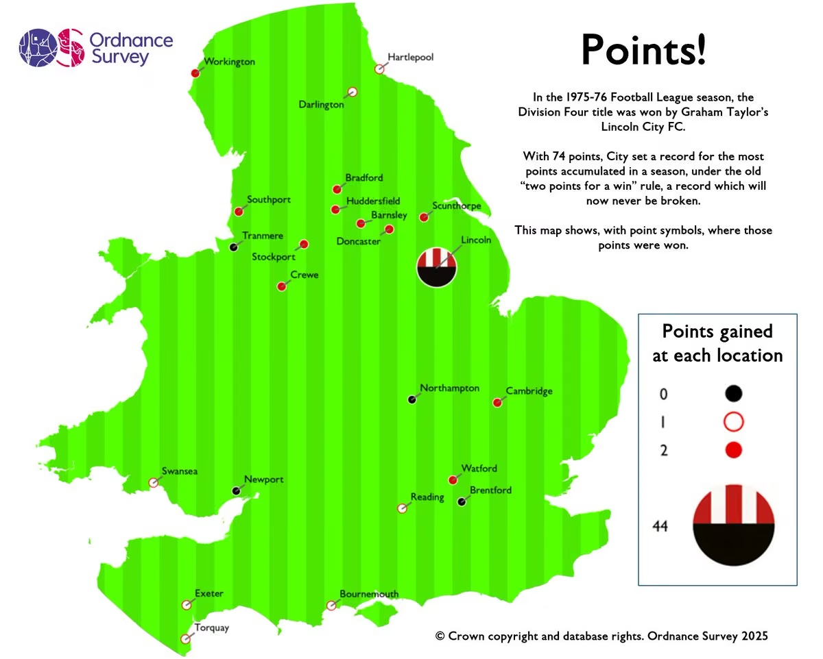
The #30daymapchallenge is back!
For Day 1 - Points, Production Manager Matt Farthing maps Lincoln City’s Division Four title-winning 1975–76 season ⚽ -
Ordnance Survey
@OrdnanceSurvey
Mappy Halloween! 🎃 Where is the spookiest place you know?
-
Ordnance Survey
@OrdnanceSurvey
Gain clarity on the physical state of every building with the latest OS NGD Buildings update with:
🏢 Physical condition attribution
🏢 Insight into under construction, built or derelict buildings
🏢 Better data for emergency planning, compliance and development
Ordnance Survey
@OrdnanceSurvey
Explore the new OS NGD data: www.ordnancesurvey.co.uk/products/os-data-hub
-
Ordnance Survey
@OrdnanceSurvey
Mappy Halloween - ghost mode edition 👻🎃 #ghostphotoshoot
-
Ordnance Survey
@OrdnanceSurvey
National street lights data in OS NGD is lighting the way to safer, smarter travel.
Over 6.5 million lights mapped from OS aerial imagery help councils plan safer routes, tackle crime hotspots & optimise infrastructure: www.ordnancesurvey.co.uk/news/new-national-street-lights-… -
Ordnance Survey
@OrdnanceSurvey
Climate risk is changing how we insure and sell property.🏘️
Discover how we’re helping the conveyancing sector move beyond postcode-level guesswork with precise location data: www.ordnancesurvey.co.uk/insights/location-data-redefinin… -
Ordnance Survey reposted
UKAuthority
@UKAuthority
@OrdnanceSurvey has released data on the location of streetlights on publicly accessible roads and paths in Great Britain.
www.ukauthority.com/articles/ordnance-survey-releases-str… #smartcities #locationdata -
Ordnance Survey
@OrdnanceSurvey
Did you know the Crier of Claiffe is the only named ghost to be on OS Maps? 👻🗺️
Deep in the Lake District, near the shores of Windermere, legend tells of a ghostly figure who once haunted Claiffe Station, wailing for lost love and scaring off unsuspecting walkers. 😱 -
Ordnance Survey
@OrdnanceSurvey
Ever wondered how your daily routes are mapped and connected? 🛣️
OS Open Roads dataset reveals the structure behind GB's road network through:
🟢 Motorway Junctions
🔗 Road Links
⚪Road Nodes
Discover more: www.ordnancesurvey.co.uk/products/os-open-roads -
Ordnance Survey reposted
Cadcorp
@cadcorp
Cadcorp ready to demo the value of @OrdnanceSurvey #osngd at #govgeo25 London today
-
Ordnance Survey
@OrdnanceSurvey
Calling UK charities! 📣
OS is seeking a new Charity Partner for 2026 - 2028 to help tackle digital exclusion in education.
We’re looking for a charity that empowers underserved communities, supports early careers, promotes STEM or explores AI.
Applications open 4 November.This media couldn't be displayed. See it on the original post.
Ordnance Survey
@OrdnanceSurvey
Learn more: www.ordnancesurvey.co.uk/news/ordnance-survey-seeks-new-c…
-
Ordnance Survey
@OrdnanceSurvey
New basemap styles just dropped! 🎉
OS NGD Tiles API now features:
🖤 Black & White
🛣️ Road
🌤️ Light
Built for developers, planners & map lovers: www.ordnancesurvey.co.uk/blog/new-basemap-styles-for-os-ngd -
Ordnance Survey
@OrdnanceSurvey
Smarter coastal planning starts here 🌊
OS NGD Land data now includes:
🌍 More complete coverage of intertidal zones
🌍 Coverage of intertidal areas beneath piers & jetties
🌍 Data for habitat monitoring & flood risk
Discover the new OS NGD data: www.ordnancesurvey.co.uk/products/os-data-hub -
Ordnance Survey reposted
UKAuthority
@UKAuthority
National Highways deploys strategic road network model www.ukauthority.com/articles/national-highways-deploys-st… @NationalHways @OrdnanceSurvey #roads #data
-
Ordnance Survey
@OrdnanceSurvey
Discover how North Wales is using location data to deliver smarter public services.
Hear from OS experts, explore OS NGD updates, and connect with your public sector peers.
📍 Llandudno, 25 November
PSGA members register free: www.ordnancesurvey.co.uk/customers/public-sector/governme… -
Ordnance Survey
@OrdnanceSurvey
We’ve teamed up with @NationalHways to launch the Network Model - bringing timely, detailed geospatial data to England’s motorways and A roads. 🛣️
Smarter journeys, less congestion, and better planning for everyone: www.ordnancesurvey.co.uk/news/new-motorway-and-a-road-mod… -
Ordnance Survey
@OrdnanceSurvey
The Royal Mail Address enhancement within OS NGD delivers an innovative solution to accessing UK Addressing data from one single, trusted source.
It includes:
📨 Full copy of Royal Mail PAF with Geometry
📨 Unique UPRN to UDPRN relationship intelligence
1/2
Ordnance Survey
@OrdnanceSurvey
📨 New and enhanced attribution
Access the new data: www.ordnancesurvey.co.uk/products/os-data-hub 2/2 -
Ordnance Survey
@OrdnanceSurvey
Inspired by Department of Conservation masterpiece on the geographical knobs of New Zealand. We present to you: The bottoms of Britain. 🍑
A bottom is a legit geographical term for low-lying land, often found in valleys; and we've discovered 4,159 of them across GB. -
Ordnance Survey
@OrdnanceSurvey
Roundabouts everywhere... a big clue to this week's #mapmonday!
Do you recognise where we are today? -
Ordnance Survey
@OrdnanceSurvey
Introducing new updates to the OS NGD 🎉
🔵 Address - Royal Mail Address
🔵 Buildings - Physical state
🔵 Land Use - Operational status
🔵 Land - Intertidal areas
🔵 Water - Continuous tidelines
🔵 Transport - Bus & Cycle lanes
Discover the new data: www.ordnancesurvey.co.uk/products/os-data-hub -
Ordnance Survey reposted
Association for Geographic Information
@GeoCommunity
Whether you are new to the industry or looking to expand your network join AGI Early Careers Network and @OrdnanceSurvey in Southampton for this excellent chance to connect and learn!
Read more and register 🔗www.agi.org.uk/agi-early-careers-networking-event-registr… -
Ordnance Survey
@OrdnanceSurvey
Explorer House was buzzing recently as we welcomed back 120 OS alumni for a special reunion!
From stories spanning the 1970s to today’s tech, we celebrated the legacy and innovation that shape Ordnance Survey. 🎉 -
Ordnance Survey
@OrdnanceSurvey
Today is National #getoutsideday 🌿
We're encouraging everyone to enjoy the outdoors just as much in colder seasons as in warmer ones.
Whether it’s a crisp walk or a muddy adventure, map your moment in OS Maps. -
Ordnance Survey
@OrdnanceSurvey
Discover how Scotland is using location data to deliver smarter public services.
Hear from OS experts, explore OS NGD updates, and connect with your public sector peers.
📍 Edinburgh, 4 November
PSGA members register free: www.ordnancesurvey.co.uk/customers/public-sector/governme… -
Ordnance Survey
@OrdnanceSurvey
At #bigdataldn, Rebekah Spratt shared how OS is helping Kinshasa, DRC build climate resilience through the Green Cities programme, funded by @FCDOGovUK 🌍
Interactive risk maps, training & data tools now empower city officials to own their future relationship with risk.
Ordnance Survey
@OrdnanceSurvey
Thanks @Snowflake & @womenindataorg!
-
Ordnance Survey reposted
Cadcorp
@cadcorp
The agenda is now online for the @Cadcorp #emergencyservices Conference 2025 - Attendees will hear from @DC_Police, @OrdnanceSurvey, @HantsIOW_fire and more - View the full agenda and book your place from here mailchi.mp/cadcorp.com/esc-25-e3 - #gis #spatialinsight
-
Ordnance Survey
@OrdnanceSurvey
We’re exhibiting at #connectedbritain on 24 - 25 September!
Join us on Stand 33 with our partners and explore how OS data powers smarter telecoms through:
📊 Geospatial Analytics
📍 Address Data Management
📈 Network Planning
www.terrapinn.com/conference/connected-britain/index.stm -
Ordnance Survey
@OrdnanceSurvey
Our CEO wants @rihanna in the boardroom… and he’s got a pretty good reason why 🎶
Nick Bolton joins @CityAM’s Boardroom Uncovered podcast to share why imagination and edge matters in business.
Listen here: www.youtube.com/watch?v=6L48QaMkK2M&list=PLaoz_LUjhNTFDeI… 🎧 -
Ordnance Survey
@OrdnanceSurvey
At Cambridge Conference 2025, global geospatial leaders shared how mapping agencies are evolving to meet today’s challenges.
From climate change and natural disasters to digital transformation, data sovereignty, and shifting policy landscapes - read more: www.ordnancesurvey.co.uk/insights/cambridge-conference-2025 -
Ordnance Survey reposted
Met Office Business
@MetOfficeB2B
Solar flares and storms become more frequent as the sun peaks in its 11-year cycle - we are currently in a solar maximum period, which can last up to a year. Increased solar activity can have wide-ranging impacts on Earth. 1/3 🧵
-
Ordnance Survey reposted
Cadcorp
@cadcorp
Join us at #govgeo25 this Autumn! Discover how @Cadcorp #gis software and services supports the #publicsector. Meet us in London. Edinburgh or Cardiff and hear from @OrdnanceSurvey experts about the value of the #osngd - Register: www.ordnancesurvey.co.uk/customers/public-sector/governme… - #spatialinsight
-
Ordnance Survey reposted
Cadcorp
@cadcorp
We're at #ets2025 today. Join us in the @OrdnanceSurvey Mapping Zone (H38) where we're showcasing #gis and #webmapping software and services, and #osngd examples for #emergencyservices - #spatialinsight
-
Ordnance Survey
@OrdnanceSurvey
This Emergency Services Day, we honour the dedication of those who keep our communities safe.
Thank you to the police, firefighters, paramedics, and all emergency teams who protect lives every day. 💙 #999day #emergencyservicesday -
Ordnance Survey
@OrdnanceSurvey
Unlock the power of location data at the heart of government. Join us at one of our one day national events this autumn to explore how accurate geospatial data is driving smarter public services across GB.
PSGA members - secure your free place: www.ordnancesurvey.co.uk/customers/public-sector/governme… #govgeo25 -
Ordnance Survey reposted
EST magazine
@ESTmagUK
'Ordnance Survey to bring innovative Mapping Zone to The Emergency Tech Show 2025'
Read the full story here: emergencyservicestimes.com/2025/09/03/ordnance-survey-to-…
#emergencyservicestimes #est -
Ordnance Survey
@OrdnanceSurvey
When seconds matter, maps aren’t just for navigation 📍
Drive-time mapping shows which areas are reachable within a set time or distance - helping organisations plan smarter routes, fix coverage gaps, and make faster, more efficient decisions. -
Ordnance Survey
@OrdnanceSurvey
We’re excited to share that OS has acquired @Dennis_Maps! 🗺️
Securing the future of our iconic paper maps and strengthening a partnership that’s delivered quality for over 15 years: www.ordnancesurvey.co.uk/news/os-acquires-full-ownership-… -
Ordnance Survey
@OrdnanceSurvey
OS joined #southamptonpride for the 5th year last weekend - a vibrant celebration of love, identity, and allyship. 🌈
We’re grateful to everyone who joined us, cheered us on, and continues to make OS a place of acceptance and support. 💙 -
Ordnance Survey
@OrdnanceSurvey
We'll be at #ets2025 on 17 - 18 September. Join us at Europe’s largest emergency services tech event to explore how OS data supports smarter, safer emergency response. 🚨
Visit the OS Mapping Zone to see real-world case studies, and partner solutions: www.emergencytechshow.com -
Ordnance Survey
@OrdnanceSurvey
Britain’s biggest map lover has been revealed! 🏆
This bank holiday, grab your favourite map and get outside. Whether you're tracing trails or exploring new corners, there’s a whole community of map lovers ready to inspire you: www.ordnancesurvey.co.uk/news/britains-biggest-map-lover-… -
Ordnance Survey
@OrdnanceSurvey
Solar flares and storms become more frequent as the sun peaks in its 11-year cycle - posing risks to GPS, comms & critical infrastructure. 🛰️
We're supporting the @metoffice forecasts with GNSS data from OS Net, helping protect nation's resilience: www.ordnancesurvey.co.uk/insights/ordnance-surveys-early-… -
Ordnance Survey
@OrdnanceSurvey
Scotland's 141-mile canal towpath network isn't just historic scenery - it's a lifeline for communities, health, business and biodiversity.
Discover how OS data is helping to create a greener and happier Scotland: www.ordnancesurvey.co.uk/blog/why-scottish-canal-towpaths… -
Ordnance Survey
@OrdnanceSurvey
We're proud to have donated high-spec drones to @LowlandRescue to support searches for high-risk missing people. Drone imagery and post-flight analysis help teams search smarter and safer: www.ordnancesurvey.co.uk/news/os-drones-to-aid-lowland-re…
-
Ordnance Survey
@OrdnanceSurvey
We’re honoured to receive the @DefenceHQ Gold Award for our support to the Armed Forces community. 🎖️ From veterans to reservists, we’re proud to champion those who serve.
-
Ordnance Survey
@OrdnanceSurvey
1.8 million UK homes sit within 100m of wildfire-prone urban edges. 🌡️
As climate change reshapes our risk landscape, OS location data is helping emergency services prepare smarter: www.ordnancesurvey.co.uk/insights/how-location-data-suppo… -
Ordnance Survey reposted
Met Office
@metoffice
Thinking of heading into the mountains this weekend? Check our mountain forecasts before you head out weather.metoffice.gov.uk/specialist-forecasts/mountain
We have teamed up with @OrdnanceSurvey & @MountainResqUK with some great advice for summer safety in the mountains
osmaps.com/discover/guides/summer-safety-in-the-mountains/
#weatherready -
Ordnance Survey
@OrdnanceSurvey
A postcode isn’t enough when every second counts. 💡 Public services need door-level precision, not just A to B insight.
Smart routing uses rich location data to power ambulances, gritters, inspections, and emergency repairs - exactly where they’re needed, when they’re needed. -
Ordnance Survey
@OrdnanceSurvey
School drop-offs shouldn’t be a safety hazard. 🚸
Bolton-le-Sands Parish Council used OS data to map traffic risks and plan safer routes to school - with the community at the heart of the solution.
See how mapping makes a difference: www.ordnancesurvey.co.uk/customers/case-studies/bolton-le… -
Ordnance Survey
@OrdnanceSurvey
Are you using OS VectorMap District or OpenMap Local for any analytical purpose? 🗺️ Make sure your voice is heard for future development of these products.
Please take a few minutes to complete our survey and share your needs and dependencies: forms.cloud.microsoft/e/Atz3apC0Mj -
Ordnance Survey
@OrdnanceSurvey
Positioning powers everything - from ambulances to agriculture.
OS is strengthening the UK’s positioning backbone with a more resilient PNT framework - powered by OS Net’s real-time, centimetre-level accuracy: www.ordnancesurvey.co.uk/insights/building-resilient-posi… -
Ordnance Survey
@OrdnanceSurvey
They did it! 🏆 #lionesses
-
Ordnance Survey
@OrdnanceSurvey
Meet Sam, at the forefront of using geospatial data to help planners design smarter, more connected communities. 👇
This media couldn't be displayed. See it on the original post. -
Ordnance Survey
@OrdnanceSurvey
Ever had cows hold up your perfectly planned route? 👀 With Community Alerts on OS Maps you can now flag unexpected obstacles.
✅ Flag and receive real-time hazard updates for fallen trees, flooded paths or other obstacles
✅ Community-powered
✅ Smarter, safer walks -
Ordnance Survey reposted
Cadcorp
@cadcorp
Learn more about the @OrdnanceSurvey #osdatahub in @Cadcorp SIS - Still time to register for this #onlinetraining course - mailchi.mp/cadcorp.com/training-sis-desktop-os-data-aug25-e2 - #gis
-
Ordnance Survey
@OrdnanceSurvey
Did you know @GlosCathedral has solar panels? OS NGD contains existing solar panel data - even for historic buildings ☀️
Helping anyone from planners to investors understand where renewables already exist. Access via the OS DataHub: www.ordnancesurvey.co.uk/products/os-ngd -
Ordnance Survey
@OrdnanceSurvey
We're back with another #mapmonday! The small patch of green in top left square of this map segment has a special meaning for many - do you know what it is?
-
Ordnance Survey
@OrdnanceSurvey
Up the hill, across the ridge, and into the wild… can you crack the 6-figure grid references? 🧭 Drop your grid guesses in the comments ⬇️
It’s #nationalmapreadingweek - the perfect time to sharpen your navigation skills and celebrate the art of exploring with confidence. -
Ordnance Survey
@OrdnanceSurvey
Learn how to explore roof data insights in this tutorial from OS Geospatial Analyst Jamie Heath!
Download sample data on the OS Data Hub: www.ordnancesurvey.co.uk/products/os-ngdThis media couldn't be displayed. See it on the original post. -
Ordnance Survey reposted
RGS-IBG Schools
@RGS_IBGschools
Have you seen @OrdnanceSurvey's new Geography Education Impact Report? 📘🌍
It highlights how they're supporting #geography education, developing talent, and raising awareness of the value of mapping beyond the classroom 🧭
Read the full report 👇
www.ordnancesurvey.co.uk/documents/report/Geography-educa… -
Ordnance Survey reposted
Geographical Association
@The_GA
This year, the inaugural Ordnance Survey Award for Primary Geography was presented to All Souls’ C of E Primary School, Rochdale.
On behalf of All Souls’ pupils and teachers their Y5 and Y6 Subject Leads for Geography – Nia and Oliver – accepted this award from Darren Bailey, the OS’s Schools Programme Manager, and Steve Brace, CEO Geographical Association.
You can read more about their excellent work in the subject here: the-ga.org/News -
Ordnance Survey reposted
Geospatial World
@geospatialworld
Nick Bolton, CEO of @OrdnanceSurvey, shares how spatial computing is transforming national mapping agencies in this keynote at Geospatial World Forum 2025.
He explains the shift from traditional cartography to data-driven ecosystems powered by AI, machine learning, and multi-source integration.
Nick highlights the national map’s evolving role as a digital foundation for applications like autonomous systems, precision agriculture, and public services. He emphasizes that true value lies in applying geospatial data to solve real-world problems—making mapping central to the future of smart, connected nations.
#geospatialworldforum2025 #gwf2025 #nickbolton #ordnancesurvey #spatialcomputing #digitaltwin #geospatialinnovation #digitalmapping #smartnations #ai #mapping #geospatialdata #locationintelligence #precisionagriculture #autonomoussystems #mappingthefutureThis media couldn't be displayed. See it on the original post. -
Ordnance Survey reposted
Royal Geographical Society (with IBG)
@RGS_IBG
This week, @OrdnanceSurvey are encouraging people of all ages to learn and enjoy the skills of navigation for #mapreadingweek 🗺️
If you're a primary school teacher looking to grow your students’ map skills, our six-lesson unit is designed to help 👇
www.rgs.org/schools/resources-for-schools/map-skills -
Ordnance Survey
@OrdnanceSurvey
Mapping is no longer about pins - it's about insight.
CTO Manish Jethwa shares how OS builds a value chain from data to customer benefit, and why future maps must 'talk back' through AI-driven interfaces: www.computerweekly.com/news/366624713/Interview-Manish-Je… -
Ordnance Survey
@OrdnanceSurvey
Ever wondered what it’s like to capture Britain from above? ✈️
Meet Phillip, OS Air Camera Operator, who combines a love of flying and cartography to help keep OS data accurate and up to date. -
Ordnance Survey
@OrdnanceSurvey
OS VectorMap District and OpenMap Local users - we want your input! 🗺️ Help shape the future of our open data products by completing our short survey.
Take part here: forms.cloud.microsoft/e/Atz3apC0Mj -
Ordnance Survey
@OrdnanceSurvey
That's a wrap on the LGA Conference & Exhibition in Liverpool this week! Great to be there with @GeoPlaceLLP to showcase how location data supports public sector transformation and to share the latest on the OS NGD.
-
Ordnance Survey reposted
GeoPlace
@GeoPlaceLLP
🚀 Heading to #lgaconf25 in Liverpool? Visit #geoplace & @OrdnanceSurvey at Stand C35 to see how geospatial data powers smarter public services
📍 #uprn, #usrn, #ngd, #nuar, Street works & routing
Plus, join our Innovation Zone session with @bathnes!
🔗lgaevents.local.gov.uk/lga/frontend/xt/accessDenied.csp?C… -
Ordnance Survey
@OrdnanceSurvey
“I’ve accepted who I am and make headway in the world because of my experiences, not in spite of them.” 🏳️🌈
This Pride Month at OS HQ, we’ve been celebrating the voices that make OS stronger. Meet Mickey, who shares their journey with identity, inclusion, and allyship. -
Ordnance Survey
@OrdnanceSurvey
The best view at Glastonbury? The one from our Flying Squad plane. ✈️
📷 2022 -
Ordnance Survey
@OrdnanceSurvey
This Armed Forces Week we're proud to recognise the vital contribution of Britain's military community - past and present.
At OS we support reservists, veterans and volunteers who apply their skills in service and beyond: www.ordnancesurvey.co.uk/blog/how-ordnance-survey-support… -
Ordnance Survey reposted
Jay Foreman
@jayforeman
NEW MAP MEN VIDEO!!!! 🗺️
For a special treat, @markcooperjones and I went to @ordnancesurvey to see how Britain's best maps are made.This media couldn't be displayed. See it on the original post. -
Ordnance Survey
@OrdnanceSurvey
Using Boundary-Line? Let us know what you think by 27 June! 💡
As part of our commitment to improving our data, we are gathering feedback from users of Boundary-Line to help shape the future roadmap of the product.
Please complete our short survey here: ordnancesurvey.qualtrics.com/jfe/form/SV_6KkA0CcDo2Dl4a2 -
Ordnance Survey
@OrdnanceSurvey
Happy 234th birthday to us! 🥳 We've come a long way since our first map in 1801, and our journey of innovation continues.
We're always evolving and helping to set the benchmark in location data to help people explore and shape our world. -
Ordnance Survey
@OrdnanceSurvey
Is your home at risk from wildfires? Our new research reveals the 20 UK cities and towns most at risk: inews.co.uk/news/environment/20-uk-cities-most-risk-wildf… @theipaper
-
Ordnance Survey
@OrdnanceSurvey
Where should EV chargers go? In partnership with @Transport4North, OS has helped identify which of the 6.4 million households in the North have driveways or off-street parking access, showing the potential to have electric vehicle (EV) chargers at home: www.ordnancesurvey.co.uk/news/new-driveway-information-he…
-
Ordnance Survey
@OrdnanceSurvey
We're exhibiting at the LGA Conference and Exhibition with @GeoPlaceLLP at the ACC Liverpool from 1-3 July - on Stand C35.
OS experts will be available to discuss the value and application of location data across the public sector and help you explore the OS NGD.
Ordnance Survey
@OrdnanceSurvey
Book here to attend: lgaevents.local.gov.uk/lga/frontend/xt/accessDenied.csp?C…
-
Ordnance Survey
@OrdnanceSurvey
We are thrilled to announce that Principal Geospatial Consultant, Duncan Moss has been awarded an OBE in the King's Birthday Honours! 🏅
This prestigious recognition highlights Duncan's outstanding contributions to geospatial data and mapping. 👏
www.ordnancesurvey.co.uk/news/duncan-moss-awarded-obe-in-… -
Ordnance Survey
@OrdnanceSurvey
What kind of roof does the UK's smallest house have? Our data knows - and it can tell you the same for over 40 million others.
Use OS NGD data to identify fire risks, support green energy planning and infrastructure, and more.
Access on the OS Data Hub: www.ordnancesurvey.co.uk/products/os-ngd -
Ordnance Survey
@OrdnanceSurvey
Huge congrats to Chloë Searl & Paul Logue - winners of the 2025 Ordnance Survey Award from @RGS_IBG, recognised for excellence in geography education at secondary level.
-
Ordnance Survey
@OrdnanceSurvey
At OS, we're proud to stand with the LGBTQ+ community this Pride Month - and every month. 🏳️🌈 We believe in creating a culture of inclusion, belonging, and respect where everyone can bring their whole selves to work.
-
Ordnance Survey
@OrdnanceSurvey
This #mapmonday we're celebrating OS Maps birthday, but can you guess how old the app will be this week? 📱🎂🎉
Let us know your guesses in the comments! -
Ordnance Survey
@OrdnanceSurvey
Planning a race or taking part in a trail run? 🏃♀️
Sustainability Lead, Ella Cowen shares how to reduce your impact before, during & after mass participation events - from route planning to poo bags: osmaps.com/discover/guides/sustainability-mass-participat… -
Ordnance Survey
@OrdnanceSurvey
Congratulations to Geospatial Data Graduate Lucy Main who has been awarded Early Career Professional of the Year at the 2025 AGI @GeoCommunity Awards for Excellence! 🎉
-
Ordnance Survey reposted
Cadcorp
@cadcorp
Spatial data from @OrdnanceSurvey is used by utility companies for more informed asset planning, efficient maintenance operation and improved customer service. View some @Cadcorp examples here: www.necsws.com/sectors/geospatial-solutions/
-
Ordnance Survey
@OrdnanceSurvey
We're celebrating 2 years with @MentalHealthUK and extending our partnership for a third year until 2026! 🎉
Over the past two years, we've been fundraising and supporting vital mental health services across the UK.
Let's continue making a difference together! 🤝This media couldn't be displayed. See it on the original post. -
Ordnance Survey
@OrdnanceSurvey
"It's more like a mission, helping supply the right mapping, the right expertise, and making it available to every part of Great Britain's public services."
Meet Gemma, Delivery Lead for PSGA who helps 6,500+ public sector organisations serve their communities with OS data.This media couldn't be displayed. See it on the original post. -
Ordnance Survey
@OrdnanceSurvey
Us returning to work after the best week off hiking and frolicking in nature. 🥾
You know the score - who knows where we are today? -
Ordnance Survey reposted
Smart Classes
@SmartClassesUK
Ahead of their joint webinar with @OrdnanceSurvey, #simanalytica's Rob Harwood explains how advances in #datascience combined with emerging #ai based automation & assistance are transforming #transportplanning, strategy, scheme evaluation & day to day ops.smartclasses.co/knowledge-base/ai-and-data-science-transf…
-
Ordnance Survey
@OrdnanceSurvey
We've joined the @Snowflake Marketplace to make OS data more accessible than ever.
Discover more: diginomica.com/how-ordnance-survey-mapping-route-better-d… -
Ordnance Survey
@OrdnanceSurvey
'I've had personal experiences with mental health support for myself and my family, so I wanted to give something back!'
Senior Production Manager, Tom Moir took part in @mentalhealthuk's annual fundraising event and shares his incredible experience. 👇This media couldn't be displayed. See it on the original post. -
Ordnance Survey reposted
Cadcorp
@cadcorp
Lunchtime demos of how the public sector can maximise @OrdnanceSurvey #osngd in #gis at @GeoPlaceLLP #geoplace2025 today - #localgovernment #emergencyservices #psga #spatialinsight
-
Ordnance Survey reposted
Land App
@thelandapp
📣 Join us for a free live webinar on how to use @OrdnanceSurvey data in Land App!
In this session, we’ll cover:
✅ How to use OS data layers, basemaps, and prints
✅ Where to access OS MasterMap and Field Boundary Downloads
✅ How to streamline land management workflows
✅ Q&A with our expert team
📅 Fri 30 May, 12 pm
🔗 Sign up: us02web.zoom.us/webinar/register/4817476620004/WN_iglDYdz…
#upcomingwebinar #landmanagement #mappingtools #livedemo -
Ordnance Survey
@OrdnanceSurvey
We're at @UtilityWeekLive today exhibiting with our partners on stand F24!
Come and chat to us about unlocking the power of location data! #uwl25 -
Ordnance Survey reposted
Cadcorp
@cadcorp
We're really excited to be at @UtilityWeekLive #uwl25 tomorrow. Come meet us on stand F24 where we will be exhibiting with @OrdnanceSurvey. Learn how OS data and the #osngd benefits utility companies and how to maximise its uses in #gis and #webmapping - register.visitcloud.com/survey/2y9ya3xsgivaf
-
Ordnance Survey
@OrdnanceSurvey
An interactive map created in collaboration with @mentalhealthuk showcases the impact of their Young People’s programmes across the UK. 🗺️
Discover the meaningful change being driven and how the next generation is being empowered: mentalhealth-uk.org/support-and-services/supporting-young… -
Ordnance Survey
@OrdnanceSurvey
This week’s Map Monday spot is near the start of the iconic South West Coastal Path 🌊⛰️ Can you name the towns where this epic journey begins and ends?
-
Ordnance Survey
@OrdnanceSurvey
Join us at the @GeoPlaceLLP Annual Conference on 22 May in London!
Connect with our technical consultants on Stand 9 to find out more about the OS National Geographic Database or get involved in our roundtable session. Our experts will be at hand to answer your questions.
GeoPlace
@GeoPlaceLLP
Exactly 4 weeks! Join 500+ professionals at #geoplace2025 - 22 May - London - explore how #locationdata is transforming local gov. Free for council officers—don’t miss live case studies, expert talks & more
Register: www.geoplace.co.uk/news-events/events/conference
#localgovernment #digitaltransformation -
Ordnance Survey
@OrdnanceSurvey
Come along to stand F24 at @UtilityWeekLive next week where we are excited to be exhibiting with OS Partners.
Talk to OS and our partners about unlocking the power of location data! #uwl25
Utility Week Live
@UtilityWeekLive
📣Exhibitor Announcement!
Meet @OrdnanceSurvey at Utility Week Live 2025 - Europe's biggest annual gathering of pan-utilities (20-21 May, NEC, Birmingham). Find them at stand F24.
Find out more: www.utilityweeklive.co.uk/exhibitors/ordnance-survey?&azl…
Meet them there: register.visitcloud.com/survey/2y9ya3xsgivaf?actioncode=N… -
Ordnance Survey
@OrdnanceSurvey
We connected with over 100 people at the @esriuk Annual Conference yesterday - sharing our latest additions to the OS NGD and answering queries at our stand. #esriukac
-
Ordnance Survey
@OrdnanceSurvey
We're exhibiting in the Partner Zone on Floor 3, Stand 1 at @esriuk conference tomorrow!
Don't miss this chance to meet us in person, and stay informed about the latest advancements in NGD, and discover how to leverage these updates to your advantage. #esriukac -
Ordnance Survey
@OrdnanceSurvey
Can you guess where these photos are from? 🛩️
Our Flying Team has kicked off their season this spring with incredible weather and even more incredible routes!
Photos captured by Air Camera Operator, Phillip Nangle. -
Ordnance Survey
@OrdnanceSurvey
Explore Great Britain like never before - through the lens of Minecraft. 🎮
Using OS OpenData, we've built a highly detailed Minecraft world that brings Britain's landscapes, towns, and coastlines to life in blocks: www.ordnancesurvey.co.uk/whats-new/minecraft-gbThis media couldn't be displayed. See it on the original post. -
Ordnance Survey
@OrdnanceSurvey
.@Geovation has welcomed a new cohort of GeoTech and PropTech start ups to its award-winning Accelerator Programme - backed by OS and @HMLandRegistry.
Meet the innovators who are tackling important challenges with property and location-powered solutions: www.ordnancesurvey.co.uk/news/new-cohort-for-award-winnin… -
Ordnance Survey
@OrdnanceSurvey
We have published a pre-market tender notification for the renewal of our Geospatial Content Enhancement Framework.
This framework is crucial for maintaining and updating geospatial data across GB: www.find-tender.service.gov.uk/Notice/009508-2025 -
Ordnance Survey
@OrdnanceSurvey
Happy #mapmonday!
This Beer is a fantastic pint of interest. -
Ordnance Survey
@OrdnanceSurvey
May the 4th be with you! 🌌 Have you visited any of these places?
Our dataviz team has mapped Star Wars filming locations across the nation 👇 -
Ordnance Survey
@OrdnanceSurvey
British Minecraft fans, access a detailed Minecraft world of Great Britain with OS OpenData - your street, your town, block by block.
Download and explore: www.ordnancesurvey.co.uk/whats-new/minecraft-gbThis media couldn't be displayed. See it on the original post. -
Ordnance Survey
@OrdnanceSurvey
Surveying a secret Second World War bunker in Folkestone that used to relay Enigma messages to Bletchley Park: www.ordnancesurvey.co.uk/blog/secret-wartime-bunker-surve… 🔍
-
Ordnance Survey
@OrdnanceSurvey
The Thames Tideway Tunnel project, supported by @LandmarkUK and powered by OS data, is revolutionising river management to prevent sewage pollution, and promote biodiversity: www.ordnancesurvey.co.uk/customers/case-studies/tideway-a…
-
Ordnance Survey
@OrdnanceSurvey
Exciting news for #minecraft gamers! OS has brought the detailed world of Great Britain to Minecraft! 🎮
Explore stunning landscapes, from London to the Scottish Highlands, in incredible detail: www.ordnancesurvey.co.uk/whats-new/minecraft-gb -
Ordnance Survey
@OrdnanceSurvey
Our latest OS NGD data reveals where solar panels are most common across GB. ☀️
These new insights, backed by OS data, are helping to drive smarter energy planning and sustainability efforts: www.ordnancesurvey.co.uk/blog/where-the-most-solar-panels… -
Ordnance Survey
@OrdnanceSurvey
This Earth Day, our data viz team has mapped where Britain's renewable energy is thriving. 🌍
#ourpowerourplanet #earthday2025 -
Ordnance Survey
@OrdnanceSurvey
Happy Easter! You could fit approximately 1.6 million mini eggs around the Isle of Eigg, only slightly more than we'll be eating this weekend. That's a sweet 32.72km.🍫
If you prefer Creme Eggs, you could fit 654k around the same island. -
Ordnance Survey
@OrdnanceSurvey
It's #trigweek! 🎉
This gridded cartogram uses data from the OS Complete Trig Archive (a legacy dataset) - revealing how trig pillar density relates to elevation across Great Britain. -
Ordnance Survey
@OrdnanceSurvey
Happy 89th birthday to the trig pillar! 🎂
First installed in 1936, trig pillars have played a vital role in mapping Great Britain and remain a much-loved part of the landscape.
Discover how we've also recreated Great Britain in Minecraft: www.ordnancesurvey.co.uk/news/minecraft-gamers-to-experie… -
Ordnance Survey
@OrdnanceSurvey
Ever wondered what's inside a trig pillar? 💡
Built in the 1930's, these concrete pillars helped OS map Great Britain with incredible accuracy, using triangulation.
Once vital to surveying, they've now become iconic landmarks for walkers and map-lovers alike. #trigweek -
Ordnance Survey
@OrdnanceSurvey
Data released by @MountainResqUK shows a dramatic growth in rescue call-outs over the past five years.
With the right maps, route planning, and navigation skills - we can all enjoy the outdoors safely and confidently: www.theguardian.com/world/2025/apr/16/record-high-british… -
Ordnance Survey
@OrdnanceSurvey
Access point data for key public buildings is now live on OS NGD. Crucial for emergency planning, situational awareness, and accessibility.
Available on the OS Data Hub: www.ordnancesurvey.co.uk/products/os-ngd -
Ordnance Survey
@OrdnanceSurvey
OS initiative @Geovation and @mhclg have launched a £1.2M PropTech Innovation Challenge to accelerate the delivery of 1.5 million new homes.
Register your interest: geovation.uk/challenges/proptech-innovation-challenge/ -
Ordnance Survey
@OrdnanceSurvey
We welcomed Minister for the Future Digital Economy and Online Safety, Maggie Jones @SciTechgovuk to OS HQ, sharing the capabilities of OS data and how it's improving people's lives on a daily basis.
@WhitchurchGirl @GDSTeamThis media couldn't be displayed. See it on the original post. -
Ordnance Survey reposted
Satellite Applications Catapult
@SatAppsCatapult
We were proud to take part in the #cambridgeconference earlier this week, @OrdnanceSurvey’s prestigious biennial gathering of national mapping agencies from around the world to explore the role of geospatial insight in addressing global challenges.
-
Ordnance Survey reposted
Maggie Jones
@WhitchurchGirl
People often think that @OrdnanceSurvey is just about maps, but they're transforming data to improve people's lives. When I visited their office, I was able to see some of the impressive & imaginative work being done.
This media couldn't be displayed. See it on the original post. -
Ordnance Survey
@OrdnanceSurvey
The OS National Geographic Database contains new data on roofs, including presence of solar panels - providing valuable insights for various sectors, including sustainability, insurance, and urban planning.
Now available on the OS Data Hub: www.ordnancesurvey.co.uk/products/os-ngd -
Ordnance Survey reposted
Maggie Jones
@WhitchurchGirl
Great to visit @OrdnanceSurvey and see the fantastic work they're doing with data. 📊The great wealth of talent and creativity I saw shows how data can be used to create transformative products to improve people’s lives.
-
Ordnance Survey
@OrdnanceSurvey
From mapping ambulance routes to identifying gaps in healthcare access, location data plays a vital role in improving patient outcomes.
Ordnance Survey
@OrdnanceSurvey
By understanding where services are needed the most, geospatial insights help local authorities to:
🔵 Plan new healthcare facilities
🔵 Improve emergency response times
🔵 Enhance accessibility by identifying barriers for healthcare
Ordnance Survey
@OrdnanceSurvey
Discover how OS is supporting a ground-breaking trial to maximise the efficiency of ambulance fleets: www.ordnancesurvey.co.uk/news/os-supports-trial-to-maximi… #worldhealthday
-
Ordnance Survey reposted
buildindigital
@buildindigital
The UK’s Ministry of Housing, Communities & Local Government has teamed up with Ordnance Survey to launch a £1.2m proptech challenge aimed at speeding up the delivery of new homes.
buildindigital.com/geovation-supports-housing-ministrys-p…
#construction #proptech @OrdnanceSurvey @mhclg -
Ordnance Survey
@OrdnanceSurvey
Never miss a tea break again! 🫖
Whether you're hiking through the countryside or exploring the city, our new OS Maps Tea Time Alarm ensures you always find the perfect spot for a brew with a view. -
Ordnance Survey
@OrdnanceSurvey
Data for over 40 million roofs is now available in the OS National Geographic Database.
Use this data to identify fire risks, support green energy planning and infrastructure, retrofitting projects and more.
Access on the OS Data Hub: www.ordnancesurvey.co.uk/products/os-ngd -
Ordnance Survey
@OrdnanceSurvey
Finding various 'Bottoms' on maps will never not be funny!
Any guesses where this rather long one is? -
Ordnance Survey reposted
shecancodehq
@SheCanCodeHQ
As part of our #internationalwomensday campaign, we asked #womenintech what the day means to them?
Here’s what the fantastic Debbie Wilson, Head of Geospatial Data at @OrdnanceSurvey had to say ⬇️
View our entire #iwd2025 campaign here 🔗 shecancode.io/accelerate-action-women-in-tech-on-what-int… -
Ordnance Survey
@OrdnanceSurvey
Introducing new updates to the OS NGD 🎉
- Roofs, including aspect, material and solar panels
- Access points to key public buildings
- Tunnels and street lights
- New sites and site access purpose
- New geographical names
Explore on the OS Data Hub: www.ordnancesurvey.co.uk/products/os-ngd -
Ordnance Survey reposted
Landmark Information Group
@LandmarkUK
It's the first ever @OrdnanceSurvey Innovation Festival today,are ready to talk big ideas and geospatial solutions with everyone who's attending!
They can't wait to get stuck in to show how we can help solve big challenges through the use of #geospatialdata! -
Ordnance Survey
@OrdnanceSurvey
Afternoon seminars are in full swing at the #ospartnerconference. These sessions provide insights on our strategies for enabling success and much more!
-
Ordnance Survey
@OrdnanceSurvey
Connecting with our partners today at OS Partner Conference - an event dedicated to empowering our partners with cutting-edge tools, valuable insights, and support needed to thrive in today's dynamic market. #ospartnerconference
-
Ordnance Survey
@OrdnanceSurvey
SimAnalytica's climate risk scenario modelling, backed by OS data, is helping organisations plan for climate change.
Discover how to improve climate risk management with location data: www.ordnancesurvey.co.uk/customers/case-studies/simanalyt… -
Ordnance Survey
@OrdnanceSurvey
This #mapmonday we have No Place for you... Do you know where this segment is?
-
Ordnance Survey reposted
The Association of Ambulance Chief Executives
@AACE_org
. @SCAS999 is working with @OrdnanceSurvey on a trial to increase the efficiency of #ambulance fleets by minimising the amount of time when ambulances must be taken off the road for unforeseen maintenance. 👇
emergencyservicestimes.com/2025/03/21/using-data-to-predi… -
Ordnance Survey
@OrdnanceSurvey
Forests are vital for enriching biodiversity. 🌲
This International Day of Forests, our GeoDataViz team have mapped forest cover using Land data from the OS National Geographic Database. -
Ordnance Survey
@OrdnanceSurvey
This ground-breaking trial with @SCAS999 ensures life-saving support is available at all times, by maximising ambulance fleet efficiency with OS data: www.ordnancesurvey.co.uk/news/os-supports-trial-to-maximi…
-
Ordnance Survey
@OrdnanceSurvey
Manifesting sunny days and picnic weather 🙌
Prepare for Spring days outside with friends and family, with 40% off OS picnic blankets: shop.osmaps.com/outdoor-gear/picnic-rugs/?_bc_fsnf=1&bran… -
Ordnance Survey
@OrdnanceSurvey
OS Open datasets are now available on @SnowflakeDB Marketplace!
It's easier than ever to access OS location data and the insights you need to improve efficiency and public services: app.snowflake.com/marketplace/providers/GZ1MOZBWYT0/Ordna… -
Ordnance Survey reposted
Utility Week Live
@UtilityWeekLive
📣Exhibitor Announcement!
Meet @OrdnanceSurvey at Utility Week Live 2025 - Europe's biggest annual gathering of pan-utilities (20-21 May, NEC, Birmingham). Find them at stand F24.
Find out more: www.utilityweeklive.co.uk/exhibitors/ordnance-survey?&azl…
Meet them there: register.visitcloud.com/survey/2y9ya3xsgivaf?actioncode=N… -
Ordnance Survey
@OrdnanceSurvey
We are thrilled to announce the unveiling of the first OS benchmark in over 25 years! 🎉
CEO Nick Bolton unveiled the benchmark at a special ceremony in Surrey, celebrating the 70th anniversary of the @135GeoSqnRE move to their current base in Ewell. -
Ordnance Survey
@OrdnanceSurvey
Monday morning feels... 😴
Do you know the ceremonial county these sleepy spots are in? -
Ordnance Survey
@OrdnanceSurvey
Map layout significantly impacts readability. From balancing elements to choosing the right scale, every detail matters in cartography.
Understanding these principles can transform how we visualise geographic data. -
Ordnance Survey
@OrdnanceSurvey
Join us at our Partner Conference in less than two weeks! This event is dedicated to empowering OS Partners with the tools, insights, and support needed to thrive in today's dynamic market.
Register now to secure your spot: www.ordnancesurvey.co.uk/customers/os-channel-partners/pa… -
Ordnance Survey reposted
SCRAN
@Scranlife
#womenshistorymonth 🗺️ working on a map at the Scottish Survey Office of Cartography & preparing to print a new map in 1947. The Ordnance Survey had introduced a new scale of mapping with measurements 1:1250 fifty inches to a mile.
🧡 @OrdnanceSurvey www.trove.scot/database/results.php?QUICKSEARCH=1&search_… -
Ordnance Survey
@OrdnanceSurvey
John Kells, an OS surveyor and dedicated Toffees fan had the unique opportunity to survey the new @EvertonStadium in Liverpool.⚽
As the site developed, OS has been responsible for capturing it for the nation’s maps and the OS NGD - the digital master map of the nation.
Ordnance Survey
@OrdnanceSurvey
Read more: www.ordnancesurvey.co.uk/blog/putting-evertons-new-stadiu…
-
Ordnance Survey
@OrdnanceSurvey
OS is empowering @activetraveleng to revolutionise cycle lane planning 🚲
OS NGD Speeds and Road Widths data provide critical insights, ensuring new cycle lanes are safe and efficient: www.ordnancesurvey.co.uk/blog/cycle-lane-planning-enhance… -
Ordnance Survey
@OrdnanceSurvey
This #internationalwomensday, we are proud to celebrate the exceptional women who drive innovation.
Join us in honouring their achievements and advocating for gender equality in tech and beyond. #iwd2025
@SheCanCodeHQ -
Ordnance Survey reposted
SmartCitiesWorld
@SmartCitiesW
OPINION: Why geospatial data is key to building a smarter future - #geospatialdata is the glue that makes other data interoperable in public and private sector projects, says John Kimmance, chief customer officer at @OrdnanceSurvey
#ai #machinelearning
www.smartcitiesworld.net/opinions/why-geospatial-data-is-… -
Ordnance Survey
@OrdnanceSurvey
We had a great time at the @BAPCOEvent in Coventry this week - discussing how geospatial data supports the Emergency Services and showcasing the capabilities of the OS National Geographic Database (NGD). #bapco
-
Ordnance Survey
@OrdnanceSurvey
OS location intelligence is helping @HiscoxUK transform how insurance risks are managed and analysed - to enable precise risk assessments and mitigate potential hazards: www.ordnancesurvey.co.uk/customers/case-studies/hiscox-us…
-
Ordnance Survey reposted
ResilienceDirect™
@RD_Gov
👏 Fantastic collaboration with @OrdnanceSurvey our Public Sector Geospatial Agreement partner on demonstrating how National Geographic Database is being utilised on @RD_Gov
📖 You can find out more about NGD on ResilienceDirect 👇
collaborate.resilience.gov.uk/home/367986/NGD -
Ordnance Survey
@OrdnanceSurvey
This #worldwildlifeday, we're proud to celebrate the rich biodiversity surrounding OS HQ, Explorer House.
Ordnance Survey
@OrdnanceSurvey
The OS Wildlife club also plays a pivotal role in promoting biodiversity and fostering a deeper connection with nature among our colleagues. #wwd2025
-
Ordnance Survey reposted
Met Office
@metoffice
If you are planning on getting out and about in the countryside this weekend here are some tips from our partners @OrdnanceSurvey on ways you can prepare yourself for an outdoor adventure 👇
#weatherready -
Ordnance Survey
@OrdnanceSurvey
Don't leave us hanging on like a yo-yo with today's #mapmonday 🎶
Do you know the Landranger map number (1:50k scale) for this segment? -
Ordnance Survey
@OrdnanceSurvey
We had a great time at @The_ABI_UK annual conference - exhibiting with our partners, @Experian and @Idoxgroup!
The conference underscored the insurance industry's vital role in fostering resilience and economic security in the UK. #abiconf25 -
Ordnance Survey reposted
SmartCitiesWorld
@SmartCitiesW
OPINION: Why geospatial data is key to building a smarter future - #geospatialdata is the glue that makes other data interoperable in public and private sector projects, says John Kimmance, chief customer officer at @OrdnanceSurvey
#ai #machinelearning
www.smartcitiesworld.net/opinions/why-geospatial-data-is-… -
Ordnance Survey reposted
Mining Remediation Authority
@MiningRemAuth
We’re delighted to be shortlisted at @TheEngineerUK #c2iawards this evening for our #partnership work with @OrdnanceSurvey
This follows our joint project to map the heating and cooling demand for mine water heat projects above abandoned coal mine workings across Great Britain. -
Ordnance Survey
@OrdnanceSurvey
Join us at the @BAPCOEvent on 5-6 March in Coventry to explore the latest cutting-edge technologies that are transforming the way we ensure public safety.
Secure your spot here: invt.io/1exbq83acid #bapco -
Ordnance Survey
@OrdnanceSurvey
We're putting the @EvertonStadium on the map! 🗺️
Catch the replay on @BBCNWT from 23:00: www.bbc.co.uk/programmes/m0028fgn -
Ordnance Survey reposted
Hill Dickinson Stadium
@EvertonStadium
It was a busy but fun morning yesterday at our new home. 🏠
-
Ordnance Survey reposted
Hill Dickinson Stadium
@EvertonStadium
Everton Stadium goes on the map! 🗺️📍
www.youtube.com/watch?v=tliN_uWll2o -
Ordnance Survey
@OrdnanceSurvey
Did you see us on @BBCBreakfast this morning talking about mapping the new @EvertonStadium? ⚽️
Catch the replay here from 3:25:33: www.bbc.co.uk/programmes/m0028chb
Pictured here: Senior Production Manager Mark Cuthbert with club legends Graham Stuart and @reid6peter. -
Ordnance Survey reposted
Roger Johnson
@RogerJ_01
Amazing to be inside @EvertonStadium, @Everton’s new home, as it goes live on @OrdnanceSurvey maps of the UK. Full report on @BBCNWT on TV at 1830. #efc
-
Ordnance Survey reposted
WorkL For Business
@WorkLforBusines
Transform your approach to change in 2025. The February edition of WorkLife Business News is here! ⬇️
Featuring...
@OrdnanceSurvey | @Tessiant_ | @ImproveWellUK | @ericsson
Read the full edition: www.flipsnack.com/workl/workl-for-business-worklife-news-…
#employeeexperience -
Ordnance Survey
@OrdnanceSurvey
The countdown is on for the OS Innovation Festival 🎉
This event will explore how location data can drive sustainable solutions and foster innovation. Join us to explore the future of geospatial: www.ordnancesurvey.co.uk/whats-new/innovation-festival -
Ordnance Survey
@OrdnanceSurvey
Join us at the @BAPCOEvent on 5-6 March! #bapco
Hear from David Chapman, Wes Clift and Egbe Manners on how PSGA data supports the Emergency Services.
Secure your spot here: www.bapco-show.co.uk -
Ordnance Survey reposted
Hill Dickinson Stadium
@EvertonStadium
👀📍Ordnance Survey on the ground.
-
Ordnance Survey reposted
Energy Manager Magazine
@PSEnergyManager
Chris Wilton, Sector Lead, Utilities, @OrdnanceSurvey writes - Digital twins: a key tool to transform the UK’s energy sector www.energymanagermagazine.co.uk/digital-twins-a-key-tool-… #energymanagement #energymanager
-
Ordnance Survey
@OrdnanceSurvey
Kate Humble's story reminds us of the simple yet powerful impact of immersing ourselves in the great outdoors: www.ordnancesurvey.co.uk/blog/kate-humble-on-her-love-for… @katehumble
-
Ordnance Survey
@OrdnanceSurvey
Happy Valentine's Day! ❤️ Love has inspired over 100 location names in Great Britain, with the following including the words close to 'Love':
❤️ 44 addresses using NGD built address data
❤️ 56 street names using NGD street address data
❤️ 5 places using Land Use Sites data -
Ordnance Survey reposted
SmartCitiesWorld
@SmartCitiesW
OPINION: Ethical AI, geospatial data and the future of digital transformation - CTO at @OrdnanceSurvey looks at how #ai will impact the world of #geospatialdata and why it has developed the responsible AI charter
#llms #generativeai #datasecurity
www.smartcitiesworld.net/opinions/ethical-ai-geospatial-d… -
Ordnance Survey reposted
Digimap for Schools
@Digimap4Schools
Don't miss Darren Bailey (@OrdnanceSurvey )'s online training session in June! More details below 👇👇
#geographyteacher
RGS-IBG Schools
@RGS_IBGschools
Interested to find out more about how to use Digimap for Schools in your teaching?
@digimap4Schools leads this free online demonstration, helping you embed GIS and mapping into your geography to engage students and enhance learning.
Book now www.rgs.org/events/upcoming-events/digimap-for-schools-ks… -
Ordnance Survey
@OrdnanceSurvey
Our cutting-edge location data is at the heart of the UK's new National Land Use Framework. This transformative project supports informed, sustainable decisions, shaping a better future for our communities and environment: www.ordnancesurvey.co.uk/blog/supporting-the-publication-… @DefraGovUK
This media couldn't be displayed. See it on the original post. -
Ordnance Survey reposted
Cadcorp
@cadcorp
We're at the #housinginnovationshow today. Stop by the @Cadcorp stand to say hello and learn more about the fundamentals and benefits of #gis, #webmapping and @OrdnanceSurvey data for #housingassociations across the UK.
-
Ordnance Survey
@OrdnanceSurvey
Every year, the GeoDataViz team at OS takes a moment to celebrate the most innovative and beautifully crafted maps that have pushed the boundaries of cartographic design.
Discover our seven favourite maps of 2024: www.ordnancesurvey.co.uk/blog/os-seven-favourite-maps-2024 -
Ordnance Survey
@OrdnanceSurvey
Ditch the gym for exploring the outdoors - with thousands of routes waiting for you: osmaps.com/discover/our-gym/ 🏃
-
Ordnance Survey
@OrdnanceSurvey
Join us at the OS Innovation Festival on 26 March! 🌟
We'll be tackling challenges that impact everyone - from biodiversity loss to data sharing, and creating solutions for various markets.
Hear from experts and connect with other industry leaders: www.ordnancesurvey.co.uk/whats-new/innovation-festival -
Ordnance Survey
@OrdnanceSurvey
Moonbility's AI-powered platform, supported by @Geovation's Accelerator Programme, is set to empower passengers with reduced mobility, offering real-time assistance and personalised support.
Transforming accessibility in the rail industry for a more inclusive future. -
Ordnance Survey reposted
Defra UK
@DefraGovUK
Today we launch a national conversation on land use in England.
Have your say: www.gov.uk/government/consultations/land-use-in-england -
Ordnance Survey
@OrdnanceSurvey
Fresh air and nature can reduce stress, boost your mood, and strengthen your immune system.
These are the proven health benefits of getting outside during the colder months: osmaps.com/discover/guides/health-benefits-of-getting-out… ❄️ -
Ordnance Survey
@OrdnanceSurvey
As we look ahead to 2025, Manish Jethwa, Chief Technology Officer shares his insights on the transformative trends shaping our future: www.ordnancesurvey.co.uk/insights/manish-jethwa-predictio…
-
Ordnance Survey reposted
Geospatial World
@geospatialworld
geospatialworld.net/videos/spatial-computing-geospatial-f…
#gwprimelive | Every map tells a story, weaving together humanity’s past, present, and future—from the migration of our ancestors to the dynamics of political shifts, environmental changes, and beyond.
With the transformative power of AI, ML, and spatial computing, maps are evolving into sophisticated tools that redefine how we understand and interact with the world.
In an exclusive conversation with Geospatial World, Nick Bolton, CEO, @OrdnanceSurvey, explores how spatial computing is shaping the geospatial future, how to optimize and strengthen the geospatial value chain, the role of cross-sector collaboration in deriving value from geospatial data, and much more.
#artificialintelligence #aiml #spatialcomputing #geospatial #mapping #geospatialdata #collaboration #data #gwprime #interview @SciTechgovuk @nibeditawriter -
Ordnance Survey
@OrdnanceSurvey
Celebrating Over 40 Years at OS! 🎉
We're thrilled to honour our incredible colleagues who have dedicated over 40 years to OS.
Their commitment and hard work has been instrumental in our journey. Here they are, receiving a historic benchmark as a token of our appreciation. -
Ordnance Survey
@OrdnanceSurvey
Are you one of the 70% who prefer getting outside for exercise vs indoor workouts?🏃
From walking and running to cycling, here's why the outdoors is the ultimate gym: www.ordnancesurvey.co.uk/news/os-urges-brits-to-swap-the-… -
Ordnance Survey reposted
RNLI
@RNLI
Severe weather warnings from @metoffice have been issued for Friday as #stormÉowyn brings gales 👇
Stay well back from stormy seas & cliff edges
Check the weather forecast & tide times
Take a phone
In an emergency call 999/112 & ask for the coastguard
#weatheraware -
Ordnance Survey reposted
Met Office
@metoffice
Storm Éowyn is bringing destructive winds to northwestern parts of the UK as it moves in, Red Weather Warnings are in force.
Read our news release for the latest information 👇 -
Ordnance Survey
@OrdnanceSurvey
⚠Red and amber weather warnings may mean it's safer to stay in and plan your next adventure instead this weekend!
Check @metoffice for your local weather forecast, be prepared to rearrange or change routes if needed, and pack extra layers. -
Ordnance Survey reposted
WildlifeKate
@katemacrae
Some species to look out for in your #biggardenbirdwatch, 24th-26th Jan! Who can you spot on my live cameras?
Let's start with the stunning great-spotted woodpecker!
@RSPBCymru @Natures_Voice @WTSWW @OrdnanceSurvey -
Ordnance Survey reposted
Geovation
@Geovation
🤔Thinking of applying to our #acceleratorprogramme? Check out what our #geovation alumni have to say about the tailored opportunities!👇🎤
Apply #geotech - www.f6s.com/geovation-spring-25-geotech/apply
Apply #proptech - www.f6s.com/geovation-spring-25-proptech/apply
Closes 23:59 Sun 02/03
#startup #preseed -
Ordnance Survey
@OrdnanceSurvey
The correct answer is 104,153! Did you get it right? 💡
Ordnance Survey
@OrdnanceSurvey
Can you guess how many images our Flying Squad captured in 2024? ✈️
-
Ordnance Survey
@OrdnanceSurvey
Location data is key to Greater Manchester's nature recovery strategy. 🌿
They're using geospatial data to protect wildlife corridors and enhance biodiversity: www.ordnancesurvey.co.uk/news/location-data-at-heart-of-n…This media couldn't be displayed. See it on the original post. -
Ordnance Survey
@OrdnanceSurvey
Here's what's in and out for sustainability and geospatial in 2025 👇
Geospatial data and location intelligence is crucial for building a resilient future, supporting more effective monitoring of climate change, sustainable investments and biodiversity. -
Ordnance Survey
@OrdnanceSurvey
Join OS and Wallace & Gromit this National Dog Walking Month in exploring the great outdoors with your furry friends: osmaps.com/discover/guides/celebrate-national-dog-walking…
-
Ordnance Survey
@OrdnanceSurvey
Can you guess how many images our Flying Squad captured in 2024? ✈️
-
Ordnance Survey
@OrdnanceSurvey
Heat networks are providing affordable, secure and reliable heat for homes across England ♨️
Appointed by @energygovuk, our new partnership with @Arup will help identify and develop heat network zones in England: www.ordnancesurvey.co.uk/news/new-partnership-to-accelera… -
Ordnance Survey reposted
Geovation
@Geovation
What can our #acceleratorprogramme do for your #proptech or #geotech #startup?
The call for applications opens Mon 13 Jan, and who better to hear about our programme than from our own cohort alumni! Find out what they have to say and how you can apply 👇
geovation.uk/apply/accelerator/ -
Ordnance Survey
@OrdnanceSurvey
We're delighted to announce Colin Hughes has been appointed as the new Chair of Ordnance Survey by the UK Government, starting on 9 March 2025!
www.ordnancesurvey.co.uk/news/colin-hughes-appointed-chai… @SciTechgovuk -
Ordnance Survey
@OrdnanceSurvey
Who needs an expensive gym membership? It's time to get back to nature. Will you join us? 🥾
Enjoy 14 days free with the OS Maps app: osmaps.com/discover/our-gym/ -
Ordnance Survey
@OrdnanceSurvey
Frosty mornings at Explorer House, OS HQ ❄️
📷 Shot by Josh Drake -
Ordnance Survey reposted
Dougal Shaw
@dougalshaw
The next episode of My Business Leader Secret will be with Nick Bolton, CEO of Britain's mapping service the @OrdnanceSurvey.
Watch more than 25 episodes from the series so far here: www.businessleader.co.uk/series/my-business-leader-secret/ -
Ordnance Survey
@OrdnanceSurvey
The OS Innovation Festival is happening this year 🌟
Industry leaders and innovators will connect to explore transformative trends in geospatial tech, AI, and sustainability: www.ordnancesurvey.co.uk/whats-new/innovation-festival -
Ordnance Survey
@OrdnanceSurvey
John Kimmance, Chief Customer Officer predicts 2025 will see a surge in geospatial data demand, AI and Machine Learning integration, and a strong focus on sustainability: www.geoconnexion.com/in-depth/drivers-for-growth-in-2025
-
Ordnance Survey reposted
British Geological Survey
@BritGeoSurvey
Did you know that you can access nine free BGS geological datasets through the @OrdnanceSurvey Data Hub?
Datasets available through the hub include:
- BGS Geology 625k
- BGS GeoSure 5km hex grid
- BGS GeoClimate UKCP18 Open
- BGS GeoCoast Open
osdatahub.os.uk/downloads/open -
Ordnance Survey
@OrdnanceSurvey
Chris Wilton, Sector Lead for Utilities explains the critical role of location data in the water sector's £88bn transformation. 🌊
Water Magazine
@watermagtweets
The January edition of Water Magazine is out now...
Read it for free by visiting:
www.watermagazine.co.uk
#waterindustry #watermagazine #waterindustrymagazine #waternews #waterindustrynews #wastewaterindustry #wastewater #stormwater #watertreatment #wastewatertreatment -
Ordnance Survey reposted
shecancodehq
@SheCanCodeHQ
Mapping Success: Sarah Driver's Journey in Tech 🌍
Sarah Driver from @OrdnanceSurvey, shares her inspiring career journey, the role models who shaped her path, and valuable advice for women in tech.
🔗 Check it out here: shecancode.io/spotlight-series-sarah-driver-production-le…
#womenintech #careerjourney -
Ordnance Survey
@OrdnanceSurvey
If you’re used to getting outside in a city location, it can come as a shock to realise just how dark it can be in the countryside.
Mountain Rescue share their expert advice for staying safe in the dark this winter: osmaps.com/discover/guides/winter-hiking-tips-from-mounta… -
Ordnance Survey
@OrdnanceSurvey
For many, the colder seasons mean crisp mornings, warm drinks and snuggling by the fire. But for others, the shorter days signal a downturn in mood and energy..
OS Champion Eli Bishop offers some tips to help you look after your mental health this winter: osmaps.com/discover/guides/manage-your-mental-health-this… -
Ordnance Survey
@OrdnanceSurvey
Keep your kids entertained during the festive season with our Kids Navigation Challenge! 🎄
Customisable OS maps let them plan routes and lead the way, making outdoor fun educational and exciting: osmaps.com/discover/guides/kids-navigation-challenge/ -
Ordnance Survey
@OrdnanceSurvey
Merry Christmas from everyone at Ordnance Survey 🎄
-
Ordnance Survey
@OrdnanceSurvey
Merry #christmaseve! 🎅
Using OS Open Zoomstack and AddressBase Core data, we've mapped 12 songs to celebrate this festive period 👇 -
Ordnance Survey
@OrdnanceSurvey
Get into the festive spirit with our top Christmas walk ideas! 🎄
From the magical Loch Morlich Circuit to the UFO Trail in Rendlesham Forest, there's a perfect walk for everyone.
Check out OS Maps and find your next adventure: osmaps.com/discover/guides/christmas-walk-ideas/ #christmaswalks -
Ordnance Survey
@OrdnanceSurvey
This year, Santa's sleigh is getting a high-tech upgrade with the help of AI from OS! 🎄🎅
From optimising his route to ensuring every gift is delivered on time, AI is making Santa's job a breeze: www.ordnancesurvey.co.uk/news/santa-gets-ai-help-this-chr… -
Ordnance Survey reposted
shecancodehq
@SheCanCodeHQ
Say hello to Kieran Ingram! 👋
Kieran is Head of Business Intelligence at @OrdnanceSurvey. She explores her career journey and advice for women in the tech industry.
Read her interview ➡️shecancode.io/spotlight-series-kieran-ingram-head-of-busi…
#spotlightseries #womenintech #womeninstem -
Ordnance Survey reposted
Department for Science, Innovation and Technology
@SciTechgovuk
The National Underground Asset Register (NUAR) will ensure that critical works like repairing power lines & fixing water mains can happen, improving worker safety, reducing delays and benefiting the economy over £400m per year.
NUAR will safeguard Christmas for years to come 🎄This media couldn't be displayed. See it on the original post. -
Ordnance Survey
@OrdnanceSurvey
In collaboration with OS, @Arup will provide technical and consulting services to identify and develop heat network zones across England.
Heat networks are one of the most cost-effective ways of providing secure, reliable and affordable heat for homes, hospitals or schools.
Ordnance Survey
@OrdnanceSurvey
Read more: www.ordnancesurvey.co.uk/news/new-partnership-to-accelera…
-
Ordnance Survey
@OrdnanceSurvey
OS Champions have shared their top picks for the best outdoor gifts this season. From waterproof backpacks to trekking poles, there's something for every adventurer: osmaps.com/discover/guides/outdoorsy-christmas-gift-ideas… #christmasgifts
-
Ordnance Survey
@OrdnanceSurvey
At OS, we’re not just mapping the world - we’re making it better.
In our latest partnership with @mentalhealthuk, we’ve developed an illuminating interactive map showcasing the transformative impact of their Young People’s programmes across the UK: www.ordnancesurvey.co.uk/blog/highlighting-the-power-and-… -
Ordnance Survey
@OrdnanceSurvey
Any guesses where our flying squad took these photos? ⛰ #internationalmountainday
-
Ordnance Survey reposted
Mining Remediation Authority
@MiningRemAuth
We’re thrilled to see our partnership work with the @OrdnanceSurvey named in the shortlist for @TheEngineerUK #c2iawards.
This follows our joint project to map the heating and cooling demand for mine water heat projects above abandoned coal mine workings across Great Britain. -
Ordnance Survey
@OrdnanceSurvey
Whether you're in urban planning or environmental research, the OS NGD Geographical Names dataset can be used to perform quick and accurate gazetteer searches as well as high-level visualisation and spatial analysis of named features and places. 🌍
-
Ordnance Survey
@OrdnanceSurvey
Welcome to the new Geovation Accelerator Cohort! 🥳
These innovative GeoTech and PropTech startups will receive expert support and cutting-edge data to drive sustainable solutions and boost the economy: www.ordnancesurvey.co.uk/news/geovation-announces-19th-ac… -
Ordnance Survey reposted
shecancodehq
@SheCanCodeHQ
Say hello to Dr Egbe Manners, Sector Product Manager at @OrdnanceSurvey! 👋
We're exploring Egbe's career journey, her role models and her advice to other women in tech
➡️ shecancode.io/spotlight-series-dr-egbe-manners-sector-pro…
#womenintech #spotlightseries #femalerolemodels -
Ordnance Survey
@OrdnanceSurvey
Chloe Thomas, a personal trainer and nutritionist, shares how hiking can improve your physical and mental wellbeing.
From boosting creativity to enhancing fitness, the benefits are endless: living360.uk/hiking-walking-benefits-chloe-thomas/
Image credit: Living 360 -
Ordnance Survey
@OrdnanceSurvey
OS and @MiningRemAuth (formerly The Coal Authority) have been shortlisted for @TheEngineerUK Collaborate to Innovate Awards for the Mine Water Heat project! #c2iawards
-
Ordnance Survey
@OrdnanceSurvey
Team Spaces have launched on the OS Data Hub 🎉
🔹 Organise your folder structure
🔹 Manage secure access to API projects
🔹 Control who can view and edit specific APIs
Now available on the OS Data Hub: osdatahub.os.uk -
Ordnance Survey reposted
Cadcorp
@cadcorp
Ready to greet delegates at the #psga event with @OrdnanceSurvey in Cardiff. Stop by the @Cadcorp stand to learn more about getting the most from the #osngd with #gis and web mapping #gcxpsga24
-
Ordnance Survey reposted
Geospatial Commission
@GeospatialC
The National Underground Asset Register (NUAR) is on track to deliver over £400 million per year of value for the UK.
Our annual project update covers progress over the last 12 months and plans for the future.
Find out more by clicking the images:👇 -
Ordnance Survey
@OrdnanceSurvey
Viability, a @Geovation and @HMLR-backed PropTech startup, is changing the way we assess housing development sites - and helping to address the housing crisis while also promoting sustainable practices: hmlandregistry.blog.gov.uk/2024/11/14/assessing-the-viabi…
-
Ordnance Survey reposted
Digital Planning UK Gov
@DigiPlanningGov
Understanding planning data and how to manage it can be tricky, but it’s key to making the planning process more efficient.
Our data team has been working with @OrdnanceSurvey to improve data sharing in planning. They’ve shared some great insights ⬇
www.linkedin.com/pulse/ordnance-survey-collaboration-faci… -
Ordnance Survey
@OrdnanceSurvey
Created by GeoDataViz Lead Paul Naylor, this choropleth depicting the locations of all cemeteries and crematoriums within GB.
Including grave sites of notable historical figures using Using OS AddressBase and OS Zoomstack for Day 30 - Final #30daymapchallenge. -
Ordnance Survey
@OrdnanceSurvey
Using OS NGD data, this 3D map represents the locations of London's 'West End' theatres, with seating capacities shown as scaled bars.
Created by Product Development Consultant Guy Heathcote for Day 29 of the #30daymapchallenge - Data (Overture). -
Ordnance Survey reposted
British Cartographic Society
@bcsmaps
Last week BCS’s Paul and Henry attended the Government Geography Profession conference at @ordnancesurvey. It was great to meet new member Anusha Das Gupta who has just joined BCS - welcome!
-
Ordnance Survey
@OrdnanceSurvey
This map illustrates the incredible journey of humpback whales, who undertake the longest mammalian migration on Earth.
Created by Associate Data Scientist Mel Marochov for Day 28 of the #30daymapchallenge - The Blue Planet. -
Ordnance Survey
@OrdnanceSurvey
Technical Relationship Consultant James Armstrong provides geospatial context to one of the most extreme and isolated parts of the world oceans, using topographic data from OSM and bathymetry data from GEBCO.
For Day 28 of the #30daymapchallenge - The Blue Planet. -
Ordnance Survey
@OrdnanceSurvey
Created by Data Architect Nate Meech, this unique micro map was crafted from falling leaves collected in the #newforest and digitised in Inkscape to resemble a macro landscape.
For Day 27 of the #30daymapchallenge - Micromapping. -
Ordnance Survey reposted
Astun Technology
@astuntech
Another great #gcxpsga24 event today with @OrdnanceSurvey in London.
It was great to see so many familiar faces and speak to some new contacts about #gis in the #publicsector.
Missed out? Sign up to our #geospatial events alert:
www.astuntechnology.com/subscribe-news/ -
Ordnance Survey reposted
Cadcorp
@cadcorp
We're also going to be at the #gcxpsga24 event in Cardiff next week. @Cadcorp will be there demo'ing how #psga members can gain maximum value from the @OrdnanceSurvey #osngd within #gis. Hope to see you there!
-
Ordnance Survey
@OrdnanceSurvey
Created by Software Engineer Dan Whitford, this map shows global flight paths using the unusual "Arctic Polar Stereographic" projection, placing the #northpole at the centre.
For Day 26 of the #30daymapchallenge - Map projections. -
Ordnance Survey
@OrdnanceSurvey
The image, created in Blender with QGIS and GIMP, features OS MasterMap data rendered using OS's 'Standard' stylesheets. It shows the location of the previous OS HQ in Southampton.
By Product Development Consultant Guy Heathcote for #30daymapchallenge Day 26 - Map projections. -
Ordnance Survey reposted
Gayle Gander
@GayleGander
It’s a geospatial week! Ahead of @GeoCommunity conference on Thursday, I’m having an *excellent* day at #gcxpsga24 talking to old friends as well as plenty of new contacts. Useful updates on @OrdnanceSurvey products, loving OS NGD Buildings
-
Ordnance Survey reposted
Cadcorp
@cadcorp
Straight into it today demo'ing how #psga members can get the most from @OrdnanceSurvey #spatialdata and the #osngd with #gis and web mapping. Stop by the @Cadcorp stand in London to learn more - #gcxpsga24
-
Ordnance Survey reposted
Mental Health UK
@mentalhealthuk
💜 Our Young People’s Programmes interactive map is live!
In collaboration with @OrdnanceSurvey, we’ve created a dynamic map showcasing the transformative impact of our Young People’s programmes across the UK.
Explore the map to find available support 👉 mentalhealth-uk.org/support-and-services/supporting-young… -
Ordnance Survey reposted
CJS News
@CountrysideNews
@OrdnanceSurvey pioneered the Geovation hub 15 years ago to foster a geospatial ecosystem for start-ups to solve real world challenges using location data. Since then, the hub has supported over 150 startups, with a combined net worth of £300 million c-js.uk/3ZljHXZ
-
Ordnance Survey
@OrdnanceSurvey
This 3D hexagon heatmap shows the TOPO changes submitted to the NGD by OS field surveyors across GB since the last #30daymapchallenge. Inspired by work analytics, it highlights data update locations.
Created by Senior Production Manager Tom Moir for Day 25 - Heat. -
Ordnance Survey
@OrdnanceSurvey
Created by Data Scientist Tom Peterken, this map shows the maximum temperature recorded across the UK each day in 2023. 🌡️
For Day 25 of the #30daymapchallenge - Heat. -
Ordnance Survey
@OrdnanceSurvey
Happy 15th birthday @Geovation! 🥳
Our initiative in association with @HMLandRegistry has empowered countless entrepreneurs, fostering a community where groundbreaking ideas flourish: www.ordnancesurvey.co.uk/news/geovation-hits-15-year-mile… -
Ordnance Survey reposted
Euan G Stevenson
@egstevenson
#30daymapchallenge
Day 24: Circles
According to @OrdnanceSurvey Open Roads data, there are 45 streets in Aberdeen, Scotland with 'Circle' in their name. Mapped using @cadcorp SIS. -
Ordnance Survey reposted
Euan G Stevenson
@egstevenson
#30daymapchallenge Day 22: 2 colours.
A map showing @OrdnanceSurvey Open Rivers within the Cairngorms National Park and overlaid on OS Miniscale relief style basemap. Created using @cadcorp SIS Desktop. -
Ordnance Survey
@OrdnanceSurvey
This contextual map is styled using only circular fills, circular points, and dotted lines, along with some text, to create a unique visual representation.
Created by Technical Geospatial Analyst Hannah Brooks for Day 24 of the #30daymapchallenge - Only circular shapes. -
Ordnance Survey
@OrdnanceSurvey
This map uses a true area projection (Hammer) to accurately depict areas, reducing distorted geometries to simple circles.
By Production Manager Matt Farthing for Day 24 of the #30daymapchallenge - Only circular shapes. -
Ordnance Survey
@OrdnanceSurvey
This map visualises the results of OS employees plotting towns and cities in Hampshire on a blank map from their memory. Southampton had the highest accuracy, while Andover scored the lowest.
By Graduate Rebekah Spratt for Day 23 of the #30daymapchallenge - Memory. -
Ordnance Survey reposted
Promap
@Promap
Todays theme for #30daymapchallenge is two colours, and unlike previous years it is just two flat colours, no gradients or shading. This map was styled with simple thin black lines and a white background, using OS Terrain 5 Contour data showing the Cairngorm National Park.
-
Ordnance Survey
@OrdnanceSurvey
Created by Field Surveyor Robert Finch, this hexogram shows the completion rate of parkrun tourism by OS runners within each Parliamentary Constituency.
For Day 22 of the #30daymapchallenge - Two Colours. -
Ordnance Survey reposted
Basemap
@basemap
Day 22 of #30daymapchallenge: Two Colours! ⚫⚪
We used @OrdnanceSurvey Zoomstack to create a simple black-and-white map, showing areas of Edinburgh within 400m walk of a bus stop using detailed footpath data. Striking & effective! #gis #mapchallenge #publictransport -
Ordnance Survey
@OrdnanceSurvey
OS digital maps have outsold physical maps for the first time 🗺 We've been making paper maps for 233 years, and there will always be a place for both. Which do you prefer?
Read more on The @Telegraph: www.telegraph.co.uk/business/2024/11/21/why-walkers-ditch… -
Ordnance Survey
@OrdnanceSurvey
Created by Technical Geospatial Analyst Hannah Brooks, this map shows the locations where bombs fell in #southampton during the Blitz, overlaid on modern-day mapping of Southampton.
For Day 21 of the #30daymapchallenge - Conflict. -
Ordnance Survey
@OrdnanceSurvey
This map shows the spatial distribution of bus stops in #guernsey, Channel Islands, using Voronoi polygons to illustrate service areas.
Created by Data Management Analyst Jacob Kilby for Day 20 of the #30daymapchallenge - Data (OpenStreetMap). -
Ordnance Survey reposted
Int'l Coalition for Sustainable Infrastructure
@sust_coalition
Out now! ⚡🏦
The Climate Resilient Infrastructure Report: A Focus on Technology explores how digital technology can enhance climate resilience through the lens of the 4 resilience phases:
🔴 Prepare
🟠 Respond
🟡 Recover
🟢 Adapt
➡Check it out: sustainability-coalition.org/publication/the-climate-resi… -
Ordnance Survey reposted
BC
@mildthing99
🔊Now + Then #pennylane🔊
Aerial photo of Penny Lane, Moseley Hill Liverpool
#melodymaker ad Feb 1967 @thebeatles
⏭️Now @Esri Imagery + @openstreetmap
⏮️Then @OrdnanceSurvey 10560 1949-71
🙏 @natlibscotmaps 3D
#30daymapchallenge
Day 20: Open Street Map maps.nls.uk/geo/explore/3d -
Ordnance Survey reposted
Cadcorp
@cadcorp
We're delighted to be supporting the #gcxpsga24 event with @OrdnanceSurvey in London next week. @Cadcorp will be there demo'ing how #psga members can gain maximum value from the #osngd within #gis. Hope to see you there!
-
Ordnance Survey
@OrdnanceSurvey
This map depicts place names using the official British Sign Language font. It explores how sign language can be integrated into maps.
Created by Data Scientist Anna Labetski for Day 19 of the #30daymapchallenge - Typography. -
Ordnance Survey reposted
New Civil Engineer
@ncedigital
🔥 @Arup will provide technical and consulting services for the identification and development of heat network zones in England, in partnership with @OrdnanceSurvey
Full story: www.newcivilengineer.com/latest/arup-and-os-partner-to-id… -
Ordnance Survey
@OrdnanceSurvey
This map uses text to highlight patterns in locations 19th-century authors considered salubrious, inspired by Victorian print advertising. It reflects on contemporary views of health and geography.
Created by Graduate Lucy Main for Day 19 of the #30daymapchallenge - Typography. -
Ordnance Survey reposted
Euan G Stevenson
@egstevenson
#30daymapchallenge
Day 18: 3D. Just a simple one today - @OrdnanceSurvey 1:250k scale colour raster draped over OS Terrain 50 DTM Grid. Made with @cadcorp SIS. -
Ordnance Survey reposted
Grand Union Paddington
@inpaddington
Here’s ours with some canine friends. 🐾 🍊
Ordnance Survey
@OrdnanceSurvey
GeoDataViz Lead Paul Naylor maps 23 #paddingtonbear statues across the UK and Ireland as part of Paddington Visits this year. 🐻
For Day 17 of the #30daymapchallenge - Collaborative map.
Find your local Paddington statue here: osmaps.com/discover/paddington-visits/ -
Ordnance Survey
@OrdnanceSurvey
Created by Product Development Consultant Guy Heathcote, this animated video features art from @TimmyMallett's south coast leg of his Great Britain circumnavigation: youtu.be/zleClpJN5tE
For Day 18 of the #30daymapchallenge - 3D. -
Ordnance Survey
@OrdnanceSurvey
GeoDataViz Lead Paul Naylor maps 23 #paddingtonbear statues across the UK and Ireland as part of Paddington Visits this year. 🐻
For Day 17 of the #30daymapchallenge - Collaborative map.
Find your local Paddington statue here: osmaps.com/discover/paddington-visits/ -
Ordnance Survey
@OrdnanceSurvey
This map highlights the locations of buildings over 10 storeys tall across Great Britain, using OS NGD Buildings and OS NGD Boundaries data. 🏢
Created by Data Management Analyst Tom Holbrook for Day 16 of the #30daymapchallenge - Choropleth. -
Ordnance Survey
@OrdnanceSurvey
Created by Production Manager Matt Farthing, this map uses the Ceremonial Counties layer of OS Open Boundaries.
Inspired by his love for France and winemaking, it captures the autumn colours of the vineyards. 🍇
For Day 16 of the #30daymapchallenge - Choropleth. -
Ordnance Survey
@OrdnanceSurvey
This map showcases 10 years of Google location data, overlaid on an @Esri base map, highlighting most places visited since having a smartphone. Created by Field Surveyor Conan Parsons for Day 15 of the #30daymapchallenge - My data.
-
Ordnance Survey reposted
Jacob L. Macdonald
@jacobmac02
🗺️ DAY 15: MY DATA - “Map something personal”… What’s the distribution of Jacob-based places around Great Britain? Using @OrdnanceSurvey place names for today’s #30daymapchallenge. Lots of Jacob’s ladders about.
-
Ordnance Survey
@OrdnanceSurvey
Created by Hannah Brooks, this hand-drawn map on an art tablet brings Terry Pratchett's Discworld to life. ✨
For Day 14 of the #30daymapchallenge - A world map. -
Ordnance Survey reposted
Cadcorp
@cadcorp
Demos are underway at the @Cadcorp stand at #gcxpsga24 York today. Stop by for your demo on how #psga members can gain maximum value from the @OrdnanceSurvey #osngd with #gis.
-
Ordnance Survey reposted
Cadcorp
@cadcorp
We're at #gcxpsga24 in York with @OrdnanceSurvey today. Stop by the @Cadcorp stand where we will demo'ing how #psga members can gain maximum value from the #osngd within #gis.
-
Ordnance Survey
@OrdnanceSurvey
Associate Data Scientist Mel Marochov created this lino print map, capturing scale and beauty of Sequoia and Kings Canyon National Park in California. Inspired by a recent visit, it’s Mel’s first time using lino to make a map. 🌲
For Day 13 of the #30daymapchallenge - A new tool -
Ordnance Survey
@OrdnanceSurvey
Digital twins are revolutionising the way we approach innovation and sustainability.
OS and @WelshGovernment are leading the change, using digital twins to monitor environmental impacts and improve wellbeing of local communities: www.ordnancesurvey.co.uk/blog/showcasing-the-value-of-dig… -
Ordnance Survey reposted
Tim Ostler
@TimOstler1
#30daymapchallenge Day 13: A new tool
Reused some data from the challenge a couple of years ago and used the vector vonoroi tool in @qgis to create this patchwork diagram bisecting the distance between @OrdnanceSurvey trig points -
Ordnance Survey reposted
Europa Technologies
@europatech
Public sector organisations in the North… please visit us at tomorrow’s #gcxpsga24 event In York, organised by @OrdnanceSurvey
See what’s new in out award-winning viaEuropa platform which supports the trio of Geospatial Commission contracts: #psga, #apgb & #psl.
🥇OS Strategic Partner
#ospartner #successlocated
www.ordnancesurvey.co.uk/customers/public-sector/geospati… -
Ordnance Survey reposted
Cadcorp
@cadcorp
Looking forward to tomorrow's #gcxpsga24 event In York with @OrdnanceSurvey. @Cadcorp will be there demo'ing how #psga members can gain maximum value from the #osngd within #gis. See you there!
-
Ordnance Survey
@OrdnanceSurvey
Created by Associate Data Scientist Rebecca Aspin, this animated map uses the building age attribute in NGD Buildings to show the increase in residential building coverage over time. 🏘️
For Day 12 of the #30daymapchallenge - Time and Space. -
Ordnance Survey reposted
Cadcorp
@cadcorp
The value of @ordnancesurvey #osngd data for #housingassociations in action #gis
-
Ordnance Survey reposted
Cadcorp
@cadcorp
How the connectivity of @ordnancesurvey #osngd data can help #housingassociations build a comprehensive portfolio view
-
Ordnance Survey
@OrdnanceSurvey
OS has teamed up with @ONS to analyse travel times and access to local amenities across England and Wales.
ONS is providing valuable insights into how accessible essential services like GP surgeries, pharmacies, and post offices are for residents: www.ordnancesurvey.co.uk/blog/using-location-data-to-meas… -
Ordnance Survey reposted
Cadcorp
@cadcorp
The @Cadcorp Housing Conference is tomorrow. We’re looking forward to a packed agenda that will explore the benefits of 'Unlocking Property Insights'. @MyGreatPlace will be presenting and @OrdnanceSurvey will be sharing #osngd case studies for #housingassociations
-
Ordnance Survey reposted
British Cartographic Society
@bcsmaps
#wewillrememberthem
David Holland, Senior Innovation & Research Scientist at @OrdnanceSurvey featured some OS maps in his origami wreath, alongside knitted and crocheted poppies made by the OS Craftography group - a beautiful tribute for display on Remembrance Day. -
Ordnance Survey
@OrdnanceSurvey
This map shows the projected arctic trade shipping routes if the #arctic sea ice melted. 🚢❄️
Created by Graduate Jonathan Allsup for Day 11 of the #30daymapchallenge - Arctic. -
Ordnance Survey
@OrdnanceSurvey
OS has a connection with the Armed Forces going back centuries. Today, we honour their service and sacrifice by paying tribute at our memorial. We will remember them. #remembrancesunday #lestweforget
-
Ordnance Survey
@OrdnanceSurvey
For Day 10 of the #30daymapchallenge - Pen & Paper, Graduate Rebekah Spratt creates this fantasy-inspired hand-drawn map using OS Maps API - Leisure data to highlight the TT racing mountain course on the #isleofman.
-
Ordnance Survey
@OrdnanceSurvey
A beautifully hand drawn map created by Production Manager Matt Farthing showing the mills of Pennsylvania for Day 10 of the #30daymapchallenge - Pen & Paper.
-
Ordnance Survey
@OrdnanceSurvey
Created by Data Scientist Anna Labetski, this map commemorates the 35th anniversary of the Berlin Wall’s fall, symbolizing the end of the Cold War.
For Day 9 of the #30daymapchallenge - AI only. -
Ordnance Survey
@OrdnanceSurvey
Created by Software Engineer Dan Whitford, this map uses HDX data to assess countries’ risk of humanitarian disasters from extreme natural events and climate change.
For Day 8 of the #30daymapchallenge - Data (HDX). -
Ordnance Survey reposted
UKAuthority
@UKAuthority
Transport Scotland chooses digital twin for roads data www.ukauthority.com/articles/transport-scotland-chooses-d… @transcotland @OrdnanceSurvey @improserv
-
Ordnance Survey
@OrdnanceSurvey
Field Surveyor Diana Chard created a map showing classic car sales turnover across GB, highlighting Yorkshire and the West Midlands as top regions.
Using OS Boundary Lines and data from a 2020 CEBR report.
For Day 7 of the #30daymapchallenge - Vintage. -
Ordnance Survey
@OrdnanceSurvey
Field Surveyor and UAS Pilot Conan Parsons created a map overlaying petrol stations and electric car chargers on a 1st edition map of #oxfordshire (1872-1887).
For Day 7 of the #30daymapchallenge - Vintage. -
Ordnance Survey
@OrdnanceSurvey
The Abauntz Lamizulo Rock Map is the oldest map in Western Europe. Engraved by Magdalenian hunter-gatherers, it depicts the area around the cave, including animals like red deer and ibex.
For Day 7 of the #30daymapchallenge - Vintage.
Ordnance Survey
@OrdnanceSurvey
Created by Field Surveyor Alicja Kalnina.
-
Ordnance Survey reposted
Basemap
@basemap
Day 7 of #30daymapchallenge: Vintage
We’ve loaded 2004 timetables into TRACC and used @OrdnanceSurvey Meridian 2 data to map access to Manchester’s CIS Tower, home to Europe’s largest solar façade at the time.
Fast forward to 2024—how does it compare with improved @BeeNetwork? -
Ordnance Survey reposted
Euan G Stevenson
@egstevenson
#30daymapchallenge
Day 6 - Raster.
A map showing drive time isochrones around GP Practices in NHS Grampian, Scotland. Produced using @Cadcorp SIS with data from @OrdnanceSurvey and spatialdata.gov.scot -
Ordnance Survey
@OrdnanceSurvey
Geospatial Graduate Lloyd John used data from NOAA's National Weather Service, Storm Prediction Center to show the frequency of EF2+ tornadoes in the USA between 1950-2023.
For Day 6 of the #30daymapchallenge - Raster. -
Ordnance Survey reposted
Astun Technology
@astuntech
Andrew and David had a great day at the first #psga event in Edinburgh, even if they had to give the chocolate away!
Stop by our stand at York, London & Cardiff for your chance to win with Astun.
#gcxpsga24 #gis @OrdnanceSurvey -
Ordnance Survey reposted
Basemap
@basemap
Day 6 of the #30daymapchallenge: Raster!
We used @OrdnanceSurvey 1:250k raster data and a rasterised travel time map to highlight hospital access in the West Midlands for arrivals between 7-9am on a Tuesday in November. Visualising healthcare accessibility! #mapchallenge #gis -
Ordnance Survey
@OrdnanceSurvey
Field Surveyor Sophie Boyadjieva has created a map of her family journeys, moving East to West and vice versa to study abroad and seek new experiences.
Despite the borders, she and her husband met in a muddy field in England.
For Day 5 of the #30daymapchallenge - A Journey. -
Ordnance Survey reposted
Cadcorp
@cadcorp
Ready to greet delegates at the #psga event with @OrdnanceSurvey. Stop by the @Cadcorp stand to learn more about getting the most from the #osngd with #gis and web mapping #gcxpsga24
-
Ordnance Survey reposted
GISCARTA
@giscartamap
#30daymapchallenge
Day 4: Hexagons
It's definitely the best way to show population density.
Also check how the scale changes as you zoom in! map.giscarta.com/viewer/87e34ff8-fc2e-46c4-82a0-aee8af5501c8
#map #mapping #gis #geospatialscience #geovis
#opendata #giscarta -
Ordnance Survey
@OrdnanceSurvey
Where are all the Bi-cons? Technical Relationship Consultant Jessica Baker joined the census maps portal data with the local authority district polygons from Boundary Line - and then turned the polygon count attribute into points.
For Day 4 of the #30daymapchallenge - Hexagons. -
Ordnance Survey reposted
Europa Technologies
@europatech
Visit our stand at one of the Geospatial Commission’s Public Sector & PSGA events and see what’s new (and coming soon) with our award winning viaEuropa platform.
Edinburgh – 5th November
York – 14th November
London – 26th November
Cardiff – 3rd December
🥇OS Strategic Partner
#gcxpsga24 @OrdnanceSurvey #ospartner #successlocated
www.ordnancesurvey.co.uk/customers/public-sector/geospati… -
Ordnance Survey reposted
Simon Kuestenmacher
@simongerman600
This elevation map by @promap consists of nothing but dots. The map is on point if you ask me…
-
Ordnance Survey reposted
Simon Kuestenmacher
@simongerman600
Roman settlements and roads in the UK as mapped by @ordnancesurvey.
-
Ordnance Survey reposted
Cadcorp
@cadcorp
Looking forward to tomorrow's #gcxpsga24 event In Edinburgh with @OrdnanceSurvey. @Cadcorp will be there demo'ing how #psga members can gain maximum value from the #osngd within #gis. Hope to see you there!
-
Ordnance Survey reposted
Alasdair Rae
@undertheraedar
A hex map for today's #30daymapchallenge hexagon theme - from the Hex capital of the world
(data from @OrdnanceSurvey OS Open Zoomstack) -
Ordnance Survey
@OrdnanceSurvey
Using OS Open Greenspace and Open Zoomstack, Technical Relationship Consultant Jessica Baker identified and ranked the 10 largest parks in GB.
For Day 3 of the #30daymapchallenge - Polygons. Check out the interactive ESRI Storymap: storymaps.arcgis.com/stories/8e5ac396b05146219cb035abdf61… -
Ordnance Survey
@OrdnanceSurvey
A visualisation of 2024 surveying work by two OS Field Surveyors in the Midlands. Lines connect home locations to job sites, coloured by work type.
Using OS Zoomastack, this was created by Field Surveyor Rob Finch for Day 2 of the #30daymapchallenge - Lines. -
Ordnance Survey
@OrdnanceSurvey
In the last year, there were nearly 2 million walking routes, 291,000 cycling routes, 256,000 running routes and other routes created in OS Maps 👏 This is where they all were 👇
Created by GeoDataViz Lead Paul Naylor For Day 2 of the #30daymapchallenge - Lines. -
Ordnance Survey reposted
Tim Ostler
@TimOstler1
#30daymapchallenge
Day 1: Points
Aiming to map as many days as I can this year. Starting with Day 1 and a simple summary of mainland GB's extremes of geography! -
Ordnance Survey reposted
Blue Light Maps
@BlueLightMaps
Buildings in Greater London, Ordnance Survey data. I particularly like how clearly you can make out the runways at Heathrow.
Definitely nothing to do with an upcoming @BlueLightMaps release.
#30daymapchallenge -
Ordnance Survey
@OrdnanceSurvey
#30daymapchallenge is back! 🗺️ Day 1 - Points. To kick off the month, Senior Production Manager Tom Moir shows the position of Roman settlements and roads as point features.
-
Ordnance Survey reposted
Basemap
@basemap
Starting the #30daymapchallenge with Day 1: Points! 🗺️✨ Here's a map showing #ptal (Public Transport Accessibility Levels) points in #leicester. It's fascinating to visualise transport accessibility! #mapchallenge #gis #publictransport
-
Ordnance Survey reposted
Promap
@Promap
The #30daymapchallenge starts today - We're kicking off with "Points", and our map of OS Terrain 5 Spot Height data. It's been styled using tiny points and graduated symbology, with a clean background helping the points do all the talking.
-
Ordnance Survey
@OrdnanceSurvey
We're looking forward to seeing everyone's #30daymapchallenge submissions and sharing our own. Let us know if you use OS data 😊🗺
Alasdair Rae
@undertheraedar
One for the mappers out there: the Ordnance Survey Data Hub (for Great Britain) keeps getting better and better - check out how many free and open datasets there are on there now
osdatahub.os.uk/downloads/open
#30daymapchallenge -
Ordnance Survey reposted
Alasdair Rae
@undertheraedar
One for the mappers out there: the Ordnance Survey Data Hub (for Great Britain) keeps getting better and better - check out how many free and open datasets there are on there now
osdatahub.os.uk/downloads/open
#30daymapchallenge -
Ordnance Survey
@OrdnanceSurvey
Mappy Halloween! 🎃 Where is the spookiest place you know?
-
Ordnance Survey
@OrdnanceSurvey
Our new data release is a game changer for emergency services.
With 26 million sites and 47 million floors now in the OS NGD - even more accurate and detailed location data is available to support emergency planning and response across Great Britain: osdatahub.os.uk -
Ordnance Survey
@OrdnanceSurvey
Making friends wherever he goes... 🐻🥪
Head on an adventure to find one of the 23 #paddingtonbear statues across the UK and Ireland as part of Paddington Visits. Find your local Paddington statue: osmaps.com/discover/paddington-visits/ -
Ordnance Survey
@OrdnanceSurvey
Ready for a spooky adventure? 👻 Discover the UK’s creepiest horror film locations!
From the eerie moors of “An American Werewolf in London” to the chilling scenes of “The Wicker Man,” explore if you dare: osmaps.com/discover/guides/horror-film-locations-uk/ -
Ordnance Survey
@OrdnanceSurvey
Congratulations to almost 20 colleagues who recently received the historic benchmark in recognition of their long service at OS!🎉
The benchmarks were used in the 20th century to record height above sea level and can also be seen in trig pillars today. -
Ordnance Survey reposted
British Geological Survey
@BritGeoSurvey
New topsoil geochemistry data provides the most extensive snapshot of environmental pollution effects around the UK.
The maps pinpoint the distribution of 41 different chemical elements, providing invaluable insights across a wide range of disciplines.
www.bgs.ac.uk/news/40-years-and-counting-new-topsoil-data… -
Ordnance Survey reposted
Barnsley Museums
@BarnsleyMuseums
#alphabetchallenge #weekqforquirky In 2019 we had a lot of fun recreating a collection of @BarnsArchives photos. The originals were taken by @OrdnanceSurvey as part of a post-war mapping project.
See more of these photos in our Picturing Hoyland blog
barnsleymuseums.art.blog/2020/05/15/picturing-hoyland/ -
Ordnance Survey reposted
Cadcorp
@cadcorp
We're delighted to be sponsoring the @HousemarkLtd #housing Data and Analytics Summit. Stop by the @Cadcorp stand to see the benefits of @OrdnanceSurvey #spatialdata and the #osngd for #housingassociations www.necsws.com/sectors/geospatial-solutions/
-
Ordnance Survey reposted
Hopewiser
@HopewiserLtd
Make smarter business decisions using @OrdnanceSurvey data.🚀
From choosing the perfect site to begin development to selecting the ideal delivery route, precise location data drives better decisions and promotes #businessgrowth
Find out more here! ⬇
www.hopewiser.com/ordnancesurvey/ -
Ordnance Survey reposted
Forestry England
@ForestryEngland
Join Wallace and Gromit for the ultimate #forestwalkies 🐾
Our brand-new activity trails across the country are packed with games and challenges for you and your pooch.
Download the route on @OrdnanceSurvey Maps and embark on your dog’s dream day out 👉 forestryeng.land/forest-walkies -
Ordnance Survey reposted
British Cartographic Society
@bcsmaps
#mapmonday Did you know our YouTube channel features an array of fascinating talks about a plethora of maps? You can browse what's available here: www.youtube.com/c/BritishCartographicSociety?cbrd=1&ucbcb=1 Which are your favourites?
-
Ordnance Survey
@OrdnanceSurvey
MAPS
-
Ordnance Survey
@OrdnanceSurvey
DATA
-
Ordnance Survey
@OrdnanceSurvey
LOCATION
-
Ordnance Survey
@OrdnanceSurvey
Welcome to our new graduates! 🎉
They're working on projects that will develop their technical expertise, and help OS build the next generation of products and services. -
Ordnance Survey
@OrdnanceSurvey
Geospatial Commission @GeospatialC Public Sector & PSGA events are only a few weeks away!
Have you secured your spot?
Discover how location data unlocks insight and better decision-making in the public sector: www.ordnancesurvey.co.uk/customers/public-sector/geospati… #gcxpsga24 -
Ordnance Survey reposted
Cadcorp
@cadcorp
Discover how location data unlocks insight for the public sector and join one of the regional #gcxpsga24 events with @OrdnanceSurvey next month. @Cadcorp will be on hand to demonstrate how to gain maximum value from the #osngd within #gis. Register here: www.ordnancesurvey.co.uk/customers/public-sector/geospati…
-
Ordnance Survey
@OrdnanceSurvey
We're thrilled that OS is now a strategic partner to the @FCDOGovUK Land Facility Programme!
We’ll work with @TetraTechIntDev led consortium to strengthen land governance in Africa, South-East Asia, and Latin America.
youtu.be/LwXVgQ7eyoM -
Ordnance Survey reposted
Interchange
@InterchangeUK
@OrdnanceSurvey becomes operator of National Underground Asset Register beta service ➡️ www.interchange-uk.com/news/ordnance-survey-becomes-opera…
#data #consturction #contractors -
Ordnance Survey
@OrdnanceSurvey
Can you guess the building with the most amount of floors in Great Britain? 🏢
We found the answer through our new number of floors data... -
Ordnance Survey reposted
Royal Geographical Society (with IBG)
@RGS_IBG
What is the origin of OS (@OrdnanceSurvey), and how did it evolve into what we know today?
Join us to hear more about the history and evolution of this unique British organisation.
📍 Oxford, 22 October 👉 www.rgs.org/events/upcoming-events/a-very-british-success… -
Ordnance Survey
@OrdnanceSurvey
Do you have a favourite base map style?
🛣️ Road: Emphasises transport networks.
🌳 Outdoor: Highlights terrain and land cover.
💡 Light: Perfect for data visualisation.
🌙 Night: Ideal for dark environments.
www.ordnancesurvey.co.uk/blog/base-map-style-updates -
Ordnance Survey
@OrdnanceSurvey
This #worldmentalhealthday, let’s take a moment to recognise the importance of talking about our mental health every day.
We're also thrilled to be extending our partnership with charity partner @mentalhealthuk - for another year!
Mental Health UK
@mentalhealthuk
Mental health is now seen as the biggest health worry across Britain.
It's never been more important to prioritise mental health in the workplace.
Here’s why. #worldmentalhealthday -
Ordnance Survey reposted
EST magazine
@ESTmagUK
'Ordnance Survey announced as future operator of the National Underground Asset Register'
Read the full story here: emergencyservicestimes.com/2024/10/09/ordnance-survey-ann…
#emergencyservicestimes #est @OrdnanceSurvey @GeospatialC -
Ordnance Survey reposted
StudiocanalUK
@StudiocanalUK
Go on your own adventure and find your nearest bench by heading over to the @OrdnanceSurvey website at osmaps.com/discover/Paddington-visits/
-
Ordnance Survey reposted
GeoPlace
@GeoPlaceLLP
Over the last 2 years, GeoPlace has been a member of the NUAR Delivery Consortium, actively supporting the onboarding of local government asset owners.
We look forward to continued collaboration with @OrdnanceSurvey & the @GeospatialC to promote safe excavation practices & unlocking the power of geospatial data to drive economic growth.
Ordnance Survey
@OrdnanceSurvey
We're excited to be appointed to deliver the National Underground Asset Register (NUAR) service.
Find out more: www.gov.uk/government/news/os-named-future-operator-of-na… -
Ordnance Survey
@OrdnanceSurvey
We're excited to be appointed to deliver the National Underground Asset Register (NUAR) service.
Find out more: www.gov.uk/government/news/os-named-future-operator-of-na… -
Ordnance Survey
@OrdnanceSurvey
We recently celebrated the launch of the new Armed Forces Network at OS.
Dedicated to our community of reservists, veterans, and military family members.
Learn more: www.ordnancesurvey.co.uk/news/new-armed-forces-network-at… -
Ordnance Survey
@OrdnanceSurvey
Are you ready to map the future? Join OS and discover a wide range of exciting careers in data, technology and beyond: ordnancesurvey.wd3.myworkdayjobs.com/OS_Careers #hiring
-
Ordnance Survey reposted
UKAuthority
@UKAuthority
@OrdnanceSurvey adds data on number of floors in buildings, interactions with bridges and access locations linked to the increased coverage of sites to OS National Geographic Database www.ukauthority.com/articles/ordnance-survey-provides-ext… #locationdata
-
Ordnance Survey reposted
EST magazine
@ESTmagUK
'Emergency services to benefit from most detailed location data from Ordnance Survey to date'
Read the full story here: emergencyservicestimes.com/2024/10/03/emergency-services-…
#emergencyservicestimes #est @OrdnanceSurvey -
Ordnance Survey
@OrdnanceSurvey
Introducing new updates to the OS National Geographic Database 🎉
This new release is a game changer for the public sector and organisations who access millions of features to help shape the world around us.
Now available on the OS Data Hub: www.ordnancesurvey.co.uk/news/supporting-the-emergency-se…
Ordnance Survey
@OrdnanceSurvey
The latest OS NGD updates include:
- Number of floors
- Land use attribution
- Bridge interactions
- Access points to sites -
Ordnance Survey reposted
UKAuthority
@UKAuthority
@OrdnanceSurvey provides extra detail in data for emergency services www.ukauthority.com/articles/ordnance-survey-provides-ext…
-
Ordnance Survey reposted
Geospatial Commission
@GeospatialC
How many floors do you think The Shard has?
For you the answer might help in a pub quiz or impress a loved one. For the emergency services that information could save lives.
They now have that data as part of the new updates to the @OrdnanceSurvey National Geographic Database. -
Ordnance Survey
@OrdnanceSurvey
Scottish Water is setting new standards in customer service by leveraging high-quality addressing data. 💧
Learn how OS data helps manage address lifecycles seamlessly: www.ordnancesurvey.co.uk/customers/case-studies/scottish-… -
Ordnance Survey
@OrdnanceSurvey
It's #nationalgetoutsideday this Sunday! Reclaim the outdoors as your own personal space for adventure, relaxation and discovery. 🚵 @OSleisure
Here is the weather forecast for this weekend by @metoffice 👇This media couldn't be displayed. See it on the original post.
Ordnance Survey
@OrdnanceSurvey
Read more: www.ordnancesurvey.co.uk/news/the-big-walk-is-here
-
Ordnance Survey reposted
Cadcorp
@cadcorp
With @Cadcorp Managed Services, you can expect expert service from
a trusted supplier. As an @OrdnanceSurvey Premium Partner, we work closely with #housingassociations to license the data they require and help them achieve their return on investment - www.necsws.com/sectors/geospatial-solutions/ -
Ordnance Survey
@OrdnanceSurvey
Discover which bridleways made the cut in our top 10 with @BritishHorse 🐴
These riding routes celebrate the best off-road access networks. Now available on the OS Maps app @OSLeisure: www.ordnancesurvey.co.uk/news/top-10-best-bridleways-adde… -
Ordnance Survey reposted
SEAN PAUL DAY
@seanpaulday
The Taxi Brains project is coming to fruition.
Prof @hugospiers and his team at University College London have been probing taxi drivers’ brains in the hope that the findings will feed into Alzheimer’s disease diagnostics.
The study also raises important questions about the future of our cognitive abilities as we become more dependent on technology to think, plan, and evaluate everything on our behalf.
@taxibrains @ARUKnews @OrdnanceSurvey @UCLPALSThis media couldn't be displayed. See it on the original post. -
Ordnance Survey reposted
Integrated Skills
@IntegratedSkill
Lots of flashing lights and great tech @emergencytechuk . Good to see @OrdnanceSurvey team on their stand, and some potential software integrations with ISL's TrafficWorx solution
-
Ordnance Survey reposted
Geospatial Commission
@GeospatialC
In August, the UN Committee of Experts on Global Geospatial Information Management (UN-GGIM) took place in New York. 🌍🗽
In our latest blog, Isabella McGuinness shares her experience of attending alongside @OrdnanceSurvey .
Find out more 👇
geospatialcommission.blog.gov.uk/2024/09/19/the-un-ggim-1… -
Ordnance Survey
@OrdnanceSurvey
Ready to make a real impact? 🌍 Join OS and help shape the future of geospatial data!
Explore exciting career opportunities and be part of a team that’s mapping the world for a better tomorrow: ordnancesurvey.wd3.myworkdayjobs.com/OS_Careers #seeabetterplace -
Ordnance Survey
@OrdnanceSurvey
We're at @emergencytechuk in Birmingham this week!
OS data plays a crucial role in helping emergency services enhance operations and improve accuracy, ensuring timely support during critical moments.
Visit stand J80 to learn how OS can support your organisation! #ets2024 -
Ordnance Survey reposted
British Cartographic Society
@bcsmaps
Congratuations to our @ordnancesurvey OS Award runner up: A Decade of Langdale/Ambleside Mountain Rescue Team Call-outs, Lake District (2013-2023), By Charlie Hewitt
-
Ordnance Survey reposted
British Cartographic Society
@bcsmaps
Congratuations to our @ordnancesurvey OS Award Winner: British Placename Mapper, by Robin Wilson.
Full map available here: placenames.rtwilson.com
X @sciremotesense
Mastodon @robintw@mastodon.me.uk -
Ordnance Survey
@OrdnanceSurvey
OS and @GeospatialC are pleased to be hosting a series of regional events this autumn!
Join us to hear about the location data and services available through the Public Sector Geospatial Agreement: www.ordnancesurvey.co.uk/customers/public-sector/geospati… #gcxpsga24 -
Ordnance Survey
@OrdnanceSurvey
CEO Nick Bolton speaks to @ITNBusiness and @DuncanGolestani at #connectedbritain about how OS is shaping the UK's future.
ITN Business
@ITNBusiness
‘@OrdnanceSurvey has been mapping Britain for over 230 years! We sat down with their CEO Nick Bolton to explore how they’re still powering the UK’s modern digital landscape. Watch the interview in our programme ‘#digitalbritain: Connecting the Nation’: business.itn.co.uk/programmes/digital-britain-connecting-…
-
Ordnance Survey
@OrdnanceSurvey
Ella Cowen, Sustainability, Property and Facilities Lead has been recognised as a future leader for sustainability. Making @edie's 30 Under 30 Class of 2024. 🎉
This initiative recognises rising sustainability stars delivering on efforts to build a better future across the UK.
Ordnance Survey
@OrdnanceSurvey
-
Ordnance Survey reposted
Geospatial Commission
@GeospatialC
Great talks at #geogovsummit in Washington DC yesterday. 🌍Our International Lead Melanie Hutchinson and David Henderson, Executive Director @ordnancesurvey joined US & Canadian peers to discuss the role of geospatial infrastructures in aiding the response to global challenges.
-
Ordnance Survey
@OrdnanceSurvey
We’ve recently added Field Boundary & Land Cover data to OS NGD, enhancing landscape monitoring and boosting biodiversity. 🌳
This helps landowners plan for biodiversity net gain: ww3.rics.org/uk/en/journals/land-journal/ordnance-survey-… @RICSnews -
Ordnance Survey
@OrdnanceSurvey
Moonbility is partnering with @nxwestmidlands to trial WheelsOnboard - a new technology initiative helping to make intermodal journeys more accessible for passengers with reduced mobility: groundtransportgroup.com/news-and-media/intermodal-journe…
Ordnance Survey
@OrdnanceSurvey
Moonbility is Innovate UK funded and supported by @Geovation, an @OrdnanceSurvey initiative in association with @HMLandRegistry.
-
Ordnance Survey
@OrdnanceSurvey
Together with @LandmarkUK and @europatech, we're here at @ConnBritain!
Come and chat to us on stand 96. #connectedbritain -
Ordnance Survey reposted
Space4Climate
@Space4Climate
Great start to #ukeo Conf with inspiring keynote from @SusanneMecklen2 . Join us at 1.30 when Krupa will be chairing session on #business & #eo with @mathiasdisney @NCEOscience & @ucl, Jason Hopkins @OrdnanceSurvey, @Sentinel_DanP @uniofleicester & Gareth Thomas @STFC_Matters
-
Ordnance Survey
@OrdnanceSurvey
Summer isn't over yet. Discover the top 20 SUP spots in the Lake District!
Whether you’re a newbie or a pro, there’s a perfect launch point waiting for you: osmaps.com/discover/guides/lake-district-paddle-boarding/ -
Ordnance Survey reposted
Robin Wilson
@sciremotesense
Very pleased to win two awards (Highly Commended for the @Avenza award for Electronic Mapping and First Prize for the @OrdnanceSurvey award) at the @bcsmaps annual conference for my British Placename Mapper - see placenames.rtwilson.com to have a play!
-
Ordnance Survey reposted
Damien Mansell
@DamienMansell
Thanks to Ordnance Survey survey team at #carto24 @BCSmaps for leading a hackathon. Our team were tasked to create a tool to build resilience / planning for flooding in Worcester. We enriched OS road network data with Environment Agency flooding risk data to create an app #geoviz
-
Ordnance Survey reposted
Cadcorp
@cadcorp
It's #colourblindawarenessday today, so here's a friendly reminder that @Cadcorp SIS supports @OrdnanceSurvey Open #zoomstack data, including its Colour Vision Deficiency friendly styles - #gis #spatialinsight #fridaymapfun
-
Ordnance Survey reposted
Hopewiser
@HopewiserLtd
Here's how Hopewiser's @OrdnanceSurvey file helped this #logistics organisation empower their delivery services.🚚🚀
Click here to read the case study! ⬇🔍📚
www.hopewiser.com/case-study/os-logistics-case-study/
#ospartner #fridayfeeling #businesssolutions -
Ordnance Survey
@OrdnanceSurvey
We're looking forward to exhibiting at the @emergencytechuk in Birmingham on 18-19 September.
We have a long and proud history of supporting the emergency services and responsive agencies in planning their responses and securing a safer future: www.emergencytechshow.com #ets2024 -
Ordnance Survey
@OrdnanceSurvey
Join us at #connectedbritain next week on stand 96.
OS CEO Nick Bolton will also be joining the Digital Britain: Connecting the Nation news-style programme with @ITNBusiness @DuncanGolestani
We're excited to be exhibiting with our partners @LandmarkUK and @europatech
ITN Business
@ITNBusiness
1 week until ‘#digitalbritain: Connecting the Nation’ goes live on our content hub! Our programme explores how digital infrastructure is shaping the future of UK connectivity. Read how organisations are bridging the #digitaldivide: business.itn.co.uk/how-organisations-are-working-to-bridg… #connectedbritain
-
Ordnance Survey reposted
buildindigital
@buildindigital
Ordnance Survey has agreed to collaborate on the use of the geospatial data to modernise planning practice and help deliver the government’s development and growth agenda.
buildindigital.com/ordnance-survey-deal-puts-data-at-hear…
#construction #planning #data @OrdnanceSurvey -
Ordnance Survey
@OrdnanceSurvey
#lakedistrict has been named the most popular National Park in Britain, according to OS Maps app data 🏞️
The data shows an impressive 278,000 routes created by outdoor enthusiasts over the past year: www.ordnancesurvey.co.uk/blog/lake-district-tops-list-of-… -
Ordnance Survey
@OrdnanceSurvey
We are thrilled to share that OS has partnered with the Digital Task Force for Planning to collaborate on digital planning innovation and promote transformative changes for the benefit of the public: www.ordnancesurvey.co.uk/news/joining-forces-with-digital…🤝
-
Ordnance Survey reposted
Cadcorp
@cadcorp
- @OrdnanceSurvey Creates Richer Buildings Data for GB - housingindustryleaders.com/os-creates-deeper-and-richer-b… - For #housingassociations, this data can be used beyond the basics of identifying properties within a flood zone but the buildings where risk might be greater. Contact @Cadcorp to learn more.
-
Ordnance Survey
@OrdnanceSurvey
OS colleagues had an amazing time at Southampton Pride last weekend. For this, our fourth time marching, OS was also a proud sponsor of #southamptonpride, celebrating and supporting the wider LGBTQ+ community! 🌈
-
Ordnance Survey
@OrdnanceSurvey
Explore the UK’s stunning landscapes sustainably 🌿
Discover eco-adventures that leave nature better than you found it - from litter picks to biodiversity surveys, embrace outdoor pursuits that protect our planet: osmaps.com/discover/guides/embracing-eco-adventure-sustai… -
Ordnance Survey
@OrdnanceSurvey
It's the 240th anniversary of a pivotal moment for modern geospatial science and the roots of OS 🎉
When engineer William Roy established his baseline on the flattest suitable ground: Hounslow Heath.
www.ordnancesurvey.co.uk/blog/william-roy-baseline-240th-… -
Ordnance Survey
@OrdnanceSurvey
Generative AI is revolutionising how we analyse and interpret spatial data.
Learn how OS are delivering smarter, faster, and more accurate geospatial solutions with AI: www.ordnancesurvey.co.uk/insights/generative-ai-geospatia… -
Ordnance Survey reposted
RSGS
@RoyalScotGeoSoc
Join us for our next Meet the Experts session, where Donna Lyndsay and James Norris from @OrdnanceSurvey will discuss how map data can help tackle global challenges such as climate change!
www.eventbrite.co.uk/e/meet-the-expert-data-for-decarboni… -
Ordnance Survey
@OrdnanceSurvey
Absolar is revolutionising solar panel assessments with OS data ☀
By combining advanced technology with precise data, they’re helping maximize energy efficiency and sustainability: www.ordnancesurvey.co.uk/customers/case-studies/absolar
#ospartner @absolar_energy -
Ordnance Survey
@OrdnanceSurvey
Our rich buildings data is transforming GB with detailed insights into building age and efficiency 💡
From precise risk assessments in insurance, to enhanced emergency response planning, geospatial is driving innovation across sectors: www.ordnancesurvey.co.uk/news/os-creates-deeper-and-riche… @Verisk_LBDUK -
Ordnance Survey
@OrdnanceSurvey
How do you plan your walking routes? 🚶 Here’s our quick guide to planning a route in 5 easy steps: osmaps.com/discover/guides/how-to-plan-a-walking-route-us…
-
Ordnance Survey
@OrdnanceSurvey
Meet the man who's mapped Scotland millimetre by millimetre for 40 years.
OS Surveyor Stuart has cycled and hiked through challenging terrains to ensure OS maps remain up to date: www.scotsman.com/news/the-man-who-has-mapped-scotland-mil… -
Ordnance Survey reposted
British Cartographic Society
@bcsmaps
Our next sponsor for the BCS conference 2024 is... @OrdnanceSurvey!
Ordnance Survey (OS) is Great Britain’s National Mapping Service. Our trusted location data and expertise is helping to build a modern digital Britain.
www.ordnancesurvey.co.uk
#carto2024 -
Ordnance Survey
@OrdnanceSurvey
What's SUP? Discover the joy of stand-up paddle boarding with these essential tips!
Whether you’re a beginner or looking to up your SUP game: osmaps.com/discover/guides/paddle-boarding-tips/ #paddleboarding -
Ordnance Survey
@OrdnanceSurvey
Can you guess where our Flying Squad has been? 👀🚀⭐
-
Ordnance Survey
@OrdnanceSurvey
Revolutionise connectivity with Complex Building Intelligence 💡
It's set to be a game-changer for broadband providers: www.ordnancesurvey.co.uk/news/os-unveils-game-changing-ad… -
Ordnance Survey
@OrdnanceSurvey
Do you know where wild camping is legal? 🏕️
@OSLeisure has some great wild camping advice including the Get Outside Wild Camping Code that we should all abide by: osmaps.com/discover/guides/is-wild-camping-legal-in-engla… -
Ordnance Survey
@OrdnanceSurvey
Love trig pillars and want to bag yourself £1,000?
Every Saturday in August, @OSLeisure will be livestreaming from a mystery trig on Instagram, TikTok, and Twitch: www.ordnancesurvey.co.uk/news/find-mystery-trig-pillar-ba… #trigpillars #touchgrass -
Ordnance Survey
@OrdnanceSurvey
Project Gigabit transforms connectivity for hard-to-reach communities 📡🏡
Here's how we’re bridging the digital divide with geospatial modelling and alternative wireless with @SciTechgovuk: www.ordnancesurvey.co.uk/blog/faster-more-reliable-connec… -
Ordnance Survey reposted
Hopewiser
@HopewiserLtd
Data from @OrdnanceSurvey never lets you down!
UPRNs are the one piece of address information that remains the same and are never re-used.
They ensure consistent results and allow you to confidently manage your address information!
Find out more HERE!
www.hopewiser.com/guide/uprn-guide-for-ecommerce-retail/ -
Ordnance Survey reposted
Cadcorp
@cadcorp
🔵 New updates to @Cadcorp SIS 9.1 | Increased @OrdnanceSurvey data support #osngd, Updated access to @EnvAgency flood-monitoring API, Additional display options in #covermodeller, Create more customised #webmaps - www.necsws.com/news/cloud-solutions/new-updates-to-sis-9-1/ - #gis #spatialinsight
-
Ordnance Survey
@OrdnanceSurvey
Green and blue spaces can boost house prices 🏡 In collaboration with @ONS, we now have up-to-date insights showing how nature adds value to our homes: www.ordnancesurvey.co.uk/blog/accounting-value-nature-hou…
-
Ordnance Survey
@OrdnanceSurvey
The OS NGD Water Theme contains both the topographic and network representations of water features, enabling topographic analysis of your local area 💧
-
Ordnance Survey
@OrdnanceSurvey
Vikings, Normans and Celts left lasting influences on Britain's place names.
With OS Open Names data, we found fascinating patterns in place names across the nation: www.ordnancesurvey.co.uk/blog/fascinating-patterns-in-bri… 🏰🔍 -
Ordnance Survey
@OrdnanceSurvey
Network providers can now use OS Complex Building Intelligence to streamline data - addressing challenges related to high-rise flats and mixed-use buildings: www.ordnancesurvey.co.uk/customers/cbi-webinar
-
Ordnance Survey
@OrdnanceSurvey
Are you looking for a new career that inspires you, and offers hybrid working?
Discover our latest roles: ordnancesurvey.wd3.myworkdayjobs.com/OS_Careers #hiring -
Ordnance Survey
@OrdnanceSurvey
AI is revolutionary for geospatial and location data industry. Here's how we're ensuring a responsible use of AI at OS: www.ordnancesurvey.co.uk/blog/responsible-ai-ordnance-survey
-
Ordnance Survey reposted
Hopewiser
@HopewiserLtd
Data from @OrdnanceSurvey supports #financial businesses in many ways.🚀
🔍Identify the level of flood risk to a given location
💡Understand #insurance claim hotposts
🗺Gain insights on the geopgrahy of an area
Learn more about OS #data ⬇
www.hopewiser.com
#ospartner -
Ordnance Survey
@OrdnanceSurvey
Manage natural landscapes more effectively with OS data. Field boundary and land cover data in the OS National Geographic Database can help:
🌱 Monitor more effectively
♻️ Reduce environmental impact
🦋 Enhance biodiversity
ww3.rics.org/uk/en/journals/land-journal/ordnance-survey-… -
Ordnance Survey
@OrdnanceSurvey
Have you seen the latest basemap updates? From road to outdoor, light to night styles. Make your maps stand out with the OS Maps API: www.ordnancesurvey.co.uk/products/os-maps-api
-
Ordnance Survey
@OrdnanceSurvey
Our colleagues are having an amazing time at the @EsriUC this week in San Diego, CA - joining 15,000 GIS professionals that use geography for good. 🌍
We're looking forward to discussions on how we can create transparency in supply chains later this week.🤝 #esriuc2024 -
Ordnance Survey reposted
RICS
@RICSnews
🌎 How can location data tackle climate change?
#ricsjournals explores how Ordnance Survey aims to make it easier to reduce environmental impact and enhance biodiversity 👇
ww3.rics.org/uk/en/journals/land-journal/ordnance-survey-… -
Ordnance Survey
@OrdnanceSurvey
We're so excited to be at @EsriUC this week, connecting with others and sharing insights 🎉
Esri User Conference
@EsriUC
Welcome to #esriuc2024! We are so excited you're here. 🤗 It's going to be a great week.
Don't miss the Plenary Session live stream today at 8:30 AM PT. If you're in San Diego,🌴 join us in Halls F-H.
🔹Sign in to watch: uc2024.esri.com/flow/esri/24uc/reglandingPlenaryOnly/form… -
Ordnance Survey
@OrdnanceSurvey
We're thrilled to partner with @charity_shc on 'Light the South Trail Map' - to help raise vital funds for Southampton Children's Hospital. 🤝
You can follow the trail of 40 large lighthouses in #southampton and #cowes by downloading the OS Maps app: lightthesouth.co.uk -
Ordnance Survey
@OrdnanceSurvey
Are you forward-thinking, commercially minded and innovative? ⚡
We're looking for people to join our Security, Engineering and Tech teams.
Explore our vacancies to see where OS can take your career: ordnancesurvey.wd3.myworkdayjobs.com/OS_Careers -
Ordnance Survey
@OrdnanceSurvey
We've been having an incredible time at @NorthumbrianH2O #innovationfestival24 - connecting with others and holding a 'TrustTees' sprint this week. 🤝
-
Ordnance Survey reposted
Hopewiser
@HopewiserLtd
We leverage our expertise to enable our valued customers to benefit from premium @OrdnanceSurvey datasets📚
We can achieve this through high quality bespoke solutions and services🚀
Click ⬇ for more on Hopewiser's OS data files 📈
www.hopewiser.com
#ospartner #dataviz -
Ordnance Survey
@OrdnanceSurvey
We're thrilled to be at the forefront of new legislation creating investment opportunities in environmental monitoring: diginomica.com/new-legislation-sparks-private-sector-inve…
-
Ordnance Survey reposted
Department for Science, Innovation and Technology
@SciTechgovuk
New Secretary of State for Science, Innovation and Technology @peterkyle met Permanent Secretary Sarah Munby as he arrived at the department today.
This government aims to use science and technology to transform public services, fuel economic growth and improve people's lives. -
Ordnance Survey
@OrdnanceSurvey
This is how we're inspiring the next generation of geospatial professionals through Geospatial Virtual Work Experience: www.ordnancesurvey.co.uk/news/inspiring-the-next-generati…
-
Ordnance Survey
@OrdnanceSurvey
Congratulations Paul Naylor, the new British Cartographic Society President🎉 @bcsmaps
Paul is a Technical Relationship Consultant at OS, leading our GeoDataViz team and will now be at the forefront of the BCS's continued success and growth 👇 -
Ordnance Survey
@OrdnanceSurvey
Our Base Map styles have been refreshed! Can you spot the difference between our old and new Light style?🌿
-
Ordnance Survey reposted
RSGS
@RoyalScotGeoSoc
We are pleased to announce the renewal of our long-standing collaboration with @OrdnanceSurvey, to help promote the essential role geography and geospatial in delivering climate solutions!
Read more: www.rsgs.org/blog/ordnance-survey-renews-long-standing-co… -
Ordnance Survey
@OrdnanceSurvey
Join us at @NorthumbrianH2O Innovation Festival, 8 - 12 July! 🌟
We'll be discussing collaborative planning for restoring a protected area and driving economic growth in our region. 🌍
Learn more and register: www.innovationfestival.org/the-festival/sprints/ordnance-… #innovationfestival24 -
Ordnance Survey
@OrdnanceSurvey
This dataviz by Data Scientist Tom Peterken shows how OS NGD Land data can showcase information about the physical surface across Britain. 🗺️
Aggregating grid cells in areas, such as #scotland, #hampshire and #southampton for more insightful detail. -
Ordnance Survey reposted
Hopewiser
@HopewiserLtd
The @OrdnanceSurvey and @BritGeoSurvey have collaborated to add various groundbreaking data products to the OS Datahub.🚀📚
Take your data to new levels by accessing above and below ground data!🗺
Read the full article ⬇
www.ordnancesurvey.co.uk/news/new-territory-for-ordnance-…
#datascientists #ospartner -
Ordnance Survey reposted
Cadcorp
@cadcorp
Next generation #webmapping offers user-friendly #gis functionality with a range of #cloud managed service options. @OrdnanceSurvey data updates are fully automated using their latest APIs. Learn more here: www.necsws.com/sectors/geospatial-solutions/ - #spatialinsight
-
Ordnance Survey
@OrdnanceSurvey
Are you at the #glastonbury Festival this weekend? 🎤
Our GeoDataViz team reflects on the festival's history since its start in the 70's - showcasing how the festival has grown over the years. @glastonbury -
Ordnance Survey
@OrdnanceSurvey
We're thrilled to share that @pointonenav has become a Licensed #ospartner and integrated OS Net into its own accurate positioning and ‘precise location as a service.’
This is how OS has helped them make precision positioning available to GB enterprises: www.ordnancesurvey.co.uk/insights/point-one-navigation-os… -
Ordnance Survey
@OrdnanceSurvey
Join our team and be part of something extraordinary! 🚀 We're hiring across Product, Data and Engineering teams: ordnancesurvey.wd3.myworkdayjobs.com/OS_Careers #hiring #seeabetterplace
-
Ordnance Survey
@OrdnanceSurvey
We now offer nine free geological datasets in collaboration with @BritGeoSurvey! 🌍
Check them out on the OS Data Hub: osdatahub.os.uk/downloads/open -
Ordnance Survey
@OrdnanceSurvey
What's the magic behind combining AI with location data? ✨
Discover how we're harnessing AI and automation for OS location data: www.ordnancesurvey.co.uk/insights/harnessing-ai-technolog… -
Ordnance Survey reposted
TfL
@TfL
And by the way, I’m going out tonight 💃
Introducing Tube Map (Taylor’s Version) ✨
#ldntaylorsversion #londontstheerastour -
Ordnance Survey
@OrdnanceSurvey
Happy 233rd birthday to us 🥳
We’ve come a long way since publishing our first map in 1801 – introducing digital mapping in 1971 - to recently launching the OS Emergency Services Gazetteer. The next chapter is only just beginning! -
Ordnance Survey reposted
Association for Geographic Information
@GeoCommunity
Congratulations to AGI Award Winner for Chairperson's Award Outstanding Service to the Geospatial Community
David Henderson, Chief Geospatial Officer @OrdnanceSurvey
Award presented by AGI Co-Chair @fergusc -
Ordnance Survey reposted
Royal Geographical Society (with IBG)
@RGS_IBG
We have signed an agreement with @OrdnanceSurvey, building on two decades of collaboration promoting geography and location data 🎉
Together, we will continue to advance geography, collaborate across sectors, and enhance teaching.
Find out more: www.rgs.org/about-us/our-work/latest-news/society-extends… -
Ordnance Survey
@OrdnanceSurvey
OS expertise is driving innovation to improve communities across the nation - and you could be part of making it happen! We're hiring: ordnancesurvey.wd3.myworkdayjobs.com/OS_Careers #hiring #seeabetterplace
-
Ordnance Survey
@OrdnanceSurvey
Join our @NorthumbrianH2O sprint at this year's Innovation Festival to explore strategies for restoring a protected area and driving economic growth 🌿 Register your place: www.innovationfestival.org/the-festival/sprints/ordnance-… #innovationfestival24
-
Ordnance Survey reposted
UKAuthority
@UKAuthority
A selection of projects have been named as winners and highly commended in the Geospatial Innovation Awards.
www.ukauthority.com/articles/winners-of-geospatial-innova… @OrdnanceSurvey @Geovation -
Ordnance Survey reposted
Hopewiser
@HopewiserLtd
Here's how @OrdnanceSurvey data helps our clients in the Land and Property sector:🗺️
✅Resolves questions in property searches
✅Helps with asset management
✅Helps find potential sites for development
Read more about OS data here ⬇
www.hopewiser.com/ordnancesurvey/
#ospartner -
Ordnance Survey
@OrdnanceSurvey
What's the magic behind combining AI with location data? ✨
Our data isn’t just lines on a map; it’s the pulse of a nation, the rhythm of cities, and the whispers of landscapes.
Discover how we're harnessing AI and automation: www.ordnancesurvey.co.uk/insights/harnessing-ai-technolog… -
Ordnance Survey reposted
UKAuthority
@UKAuthority
Winners of the Geospatial Innovation Awards www.ukauthority.com/articles/winners-of-geospatial-innova… @OrdnanceSurvey @Geovation
-
Ordnance Survey
@OrdnanceSurvey
Where do you think the highest and lowest roads in Britain are? 🛣️
We've collaborated with @Jeep_UK to find out: www.ordnancesurvey.co.uk/news/highest-and-lowest-roads -
Ordnance Survey
@OrdnanceSurvey
We've cracked the formula for the perfect walk. 🌳
According to our recent poll it's: Circular + 1 to 4 miles long + lovely weather + a beautiful view + flat .
Do you agree? Let us know what yours would be 😊 -
Ordnance Survey
@OrdnanceSurvey
Learn how @IceWarriorJim is gauging what's happening to the five extreme environments of Earth, to help empower decision-makers in politics, commerce and society to make better informed decisions. Learn more @at_RIN's Evening Talks 18 June at @RGS_IBG: rin.org.uk/event/NewFrontiersAndSustainability
-
Ordnance Survey
@OrdnanceSurvey
Have you cycled this #bikeweek? 🚲
We're celebrating all those who cycle and encourage more cycling. Cycling can help you feel happier, healthier, greener and more connected. -
Ordnance Survey reposted
CJS News
@CountrysideNews
Celebrating visionaries in geospatial innovation - Geovation announces the winners of its second international Geospatial Innovation Awards - @OrdnanceSurvey c-js.uk/4bWmRFF
-
Ordnance Survey
@OrdnanceSurvey
Mega constellations of satellites in low earth orbit can help address @UN_SDG challenges such as food security, climate change and global connectivity 🛰
To learn how, join @MarekZiebart @at_RIN's Evening Talks: New Frontiers & Sustainability, 18 June at @RGS_IBG.
Ordnance Survey
@OrdnanceSurvey
-
Ordnance Survey
@OrdnanceSurvey
Looking for your next adventure? It's an exciting time to join OS. Our location data is at the heart of helping the nation become more healthy, connected and sustainable. Discover our latest roles: ordnancesurvey.wd3.myworkdayjobs.com/en-US/OS_Careers/jobs #hiring #seeabetterplace
-
Ordnance Survey
@OrdnanceSurvey
It was an incredible evening at The Geospatial Innovation Awards - celebrating people that have created the best geospatial solutions to empower communities, shape landscapes, and safeguard our planet 🤝
Congratulations to all the winners and shortlisted applicants!🏆 @Geovation -
Ordnance Survey
@OrdnanceSurvey
With maps in hand, our @OSLeisure Outsiders have teamed up with 3 Insiders who don’t know their tent poles from their walking sticks, for the chance to win £10k for charity.
Meet the participants: osmaps.com/discover/touch-grass/
#ostouchgrass -
Ordnance Survey
@OrdnanceSurvey
Nathan Ward, Channel Sales Development Manager, discusses how Unique Property Reference Numbers are the key to unlocking greater efficiencies in property and insurance sectors: financeday.co.uk/unique-property-reference-numbers-the-ke… #uprn
-
Ordnance Survey reposted
British Cartographic Society
@bcsmaps
Been busy making maps this last year? Then we have the best place to show them off with the BCS Annual Awards 2024 - entry forms now live! (Until 23rd June)
If you have used OS data in an innovate or exciting way then enter the @OrdnanceSurvey award www.cartography.org.uk/awards -
Ordnance Survey
@OrdnanceSurvey
We're looking forward to joining Civil Service Live tomorrow in Birmingham! Speak to us to discover how you can also win 12 months access to OS Maps Premium. 🎁
📍 Join OS and @GeospatialC on stands 61 & 62 #civilservicelive @UKCivilService -
Ordnance Survey
@OrdnanceSurvey
Flex your map reading skills with our #nationalmapreadingweek Quiz! What score did you get? osmaps.com/discover/guides/national-map-reading-week-2024… #nmrw
-
Ordnance Survey
@OrdnanceSurvey
This #nationalmapreadingweek, we're inviting people to grab a map (paper or digital), and get outside safely for an adventure: osmaps.com/discover/guides/map-reading-week/ #nmrw
Mountain Rescue England and Wales also recommend the OS Maps App when heading out to UK's National Parks. -
Ordnance Survey
@OrdnanceSurvey
This week, more than 700 OS colleagues connected at Explorer House and in locations across GB for Activity Day 🏃 Discover the highlights 👇
We were also joined by a special guest - Former European, Commonwealth & World Champion @Iwanrunner 🏆 -
Ordnance Survey
@OrdnanceSurvey
This week, OS colleagues attended @GEOBusinessShow to share their insights on topics, such as:
💡 Revolutionising sustainable practices with Earth Observation technology
💡 The importance of geospatial data standards and how these can help deliver government policy
Ordnance Survey
@OrdnanceSurvey
💡 Professional development and apprenticeships: Unlocking the potential
💡 Unleashing innovation with geospatial data: Powering a sustainable future
💡 The importance of accurate and resilient positioning
#geobusiness -
Ordnance Survey
@OrdnanceSurvey
Congratulations to Product Manager Egbe Manners who was awarded AGI Geospatial Professional of the Year 2024 for her contribution to the OS Emergency Street Gazetteer. And to David Henderson, Chief Geospatial Officer - awarded for Outstanding Service to the Geospatial Community🎉
-
Ordnance Survey
@OrdnanceSurvey
Looking for your next career move? We're hiring:
🔵 Server Support Technician
🔵 Software Engineer
🔵 Senior User Interface Designer
Apply online: ordnancesurvey.wd3.myworkdayjobs.com/OS_Careers #seeabetterplace -
Ordnance Survey
@OrdnanceSurvey
It was great to hear from Hazel Hendley on the panel discussing apprenticeships and professional development! #geobusiness
Addy Pope
@GIS4HE
Excited to hear more about professional development and degree apprenticeships with the @RGS_IBG @GEOBusinessShow #gis #geography
-
Ordnance Survey
@OrdnanceSurvey
On the 80th anniversary of D-Day, we're reminded of the sacrifice of those that fought for our freedom. Including OS colleagues.
120 million maps were made for the Normandy Landings alone, and 342 million were produced for the entire war effort. -
Ordnance Survey
@OrdnanceSurvey
Geospatial data standards. Why bother?
Find out at #geobusiness tomorrow with OS Data Standards Lead Allan Jamieson, 12:30 on the GIS and data stage.
#gis #datastandards #geospatialThis post is unavailable. See it on X. -
Ordnance Survey reposted
RGS-IBG Schools
@RGS_IBGschools
Join us for a @digimap4schools showcase. Darren Bailey @ordnancesurvey will lead you through its functionality, map layers and more. He will also share ideas for embedding online mapping activities into the curriculum.
www.rgs.org/events/upcoming-events/digimap-for-schools-fo… -
Ordnance Survey reposted
Space4Climate
@Space4Climate
Welcome to @GEOBusinessShow! Don't forget to join us & our experts 12.30, Earth Insights stage, to demystify satellite climate data services - EO for GEO! @OrdnanceSurvey @4_intelligence @GeoByENVI #agtelligence
#earthobservation #satellitedata #climateaction #geobusiness -
Ordnance Survey reposted
Geographical Association
@The_GA
The day you've been waiting for is upon us!
Geographers, are you ready?? Don't forget to share your resources, and any pictures of your fieldwork adventures all through the month.
#nationalfestivaloffieldwork -
Ordnance Survey
@OrdnanceSurvey
How would you rate your map reading skills? Brushing up on your map reading can help keep you safe and give you more room for adventure ⛰️
Learn how to navigate the outdoors safely: osmaps.com/discover/guides/map-reading-week/ #nmrw #mapreading -
Ordnance Survey
@OrdnanceSurvey
We're thrilled to recognise the winners of our @RGS_IBG Excellence in Geography Education at Secondary Level Award 🥇
As role models, both Fiona and Cyrus are making significant contributions to the thriving geographical communities we enjoy here in the UK. Congratulations! 🎉 -
Ordnance Survey reposted
Jeep UK
@Jeep_UK
Adventure is in the DNA of Jeep. Is it a part of yours?
Tell us about your most memorable adventure... 📖
To discover more of Jeep and @OrdnanceSurvey's Off the Beaten Track Locations, visit here: www.jeep.co.uk/get-lost-map -
Ordnance Survey
@OrdnanceSurvey
What is a map? 🤔
Post not available here, view on X
Ordnance Survey
@OrdnanceSurvey
🗺️ Thematic - portraying information such as population density or environmental metrics, where data has a geographical element attached to it
Ordnance Survey
@OrdnanceSurvey
🗺️ Web - allowing users to interact, with functionality to search for things included within it.
#nationalmapreadingweek #nmrw -
Ordnance Survey reposted
Alasdair Rae
@undertheraedar
If you haven't checked out the @OrdnanceSurvey open data hub lately, look again - tons more great datasets for all of Great Britain on there now, free to use
osdatahub.os.uk/downloads/open -
Ordnance Survey
@OrdnanceSurvey
Join a cartography masterclass with our experts! In this free webinar - meet our cartographers to learn more about the fundamentals of map making 🗺️
⏰ 6th June at 7pm.
Secure your spot: events.teams.microsoft.com/event/fd84ff44-e2cd-44e3-ac03-… #cartography #mapmaking #mapmasterclass -
Ordnance Survey
@OrdnanceSurvey
Are you interested in mapping land and habitats to plan and improve biodiversity? 🌿 We are pleased to support our Partner @esriuk as they're hosting a webinar with @NHSNSS on 6th June: register.gotowebinar.com/register/3526659795304044895?sou…
-
Ordnance Survey reposted
UKAuthority
@UKAuthority
@OrdnanceSurvey adds geological datasets to OS Data Hub www.ukauthority.com/articles/ordnance-survey-adds-geologi… @BritGeoSurvey #geospatial
-
Ordnance Survey
@OrdnanceSurvey
We’re venturing into new territory with @BritGeoSurvey! 🌍 Enhancing OS Data Hub data with authoritative geological data including bedrock geology, soil parent material, hydrogeology and more.
Learn more: www.ordnancesurvey.co.uk/news/new-territory-for-ordnance-… -
Ordnance Survey
@OrdnanceSurvey
Being able to respond effectively and efficiently to emergencies, such as flooding or wildfires, is crucial for protecting lives, infrastructure, and the environment.
This is how location data is supporting local resilience training: www.ordnancesurvey.co.uk/blog/location-data-supporting-lo… #seeabetterplace -
Ordnance Survey reposted
BBC Coventry & Warwickshire
@BBCCWR
Mollie's sitting in for Donna on Sunday Breakfast from 6am. On the way:
- Hear about increasing congregations at our local churches
- A new tool from @OrdnanceSurvey to help emergency services
- and a spiritual garden at a Whitchurch school
Listen live www.bbc.co.uk/programmes/p0gksyw5?at_bbc_team=editorial -
Ordnance Survey
@OrdnanceSurvey
Do you know where the Hairy Caterpillar is? 🐛 For emergency services getting to the right place, whatever it is called locally, as quickly as possible can saves lives 👇
-
Ordnance Survey
@OrdnanceSurvey
Research has revealed that our remote sensing surveyors brains see the world differently, as their brains have adapted to view aerial imagery vs non-surveyors: www.ordnancesurvey.co.uk/news/how-expert-mapmakers-see-wo… #remotesensing
-
Ordnance Survey
@OrdnanceSurvey
The smallest efforts and individual actions can have a ripple effect, leading to positive change, and a brighter future for everyone.
Discover the latest roles at OS and be part of the future of mapping: ordnancesurvey.wd3.myworkdayjobs.com/OS_Careers #hiring -
Ordnance Survey
@OrdnanceSurvey
Meet the GeoTech and PropTech start-ups transforming the industry as part of the @Geovation Accelerator Programme: www.ordnancesurvey.co.uk/news/success-for-startups-on-geo…
-
Ordnance Survey reposted
RGS-IBG Schools
@RGS_IBGschools
Join us for a @digimap4schools showcase. Darren Bailey @ordnancesurvey will lead you through its functionality, map layers and more. He will also share ideas for embedding online mapping activities into the curriculum.
www.rgs.org/events/upcoming-events/digimap-for-schools-fo… -
Ordnance Survey reposted
Integrated Skills
@IntegratedSkill
Great to talk with our partner @OrdnanceSurvey at the @UtilityWeekLive event. Route planning for meter readers discussed #uwl2024
-
Ordnance Survey reposted
Digimap for Schools
@Digimap4Schools
🏫 Looking for in-person school training for 2024-2025? Register your interest with @OrdnanceSurvey for sessions at your school! Find more details about their teacher training support: www.ordnancesurvey.co.uk/education/teacher-resources/teac…
#geographyteacher -
Ordnance Survey reposted
Engine Shed
@EngineShed_BB
In our latest Let's Chat interview, we sat down with Isabelle Chatel de Brancion, Business and Innovation Lead @Geovation, to find out what the @OrdnanceSurvey initiative can offer to startups and businesses in the West of England. 💬🌎📍
engine-shed.co.uk/news/lets-chat-isabelle-chatel-de-branc… -
Ordnance Survey
@OrdnanceSurvey
Come and chat to us on stand H16 at @UtilityWeekLive about unlocking the power of location data. 💡 #uwl24
🔹Geospatial Data
🔹Secure Data Sharing
🔹Address Lifecycle Management
🔹Geospatial Analytics & Insight
🔹Consultancy Services -
Ordnance Survey
@OrdnanceSurvey
OS Gardening Club has planted tens of thousands of wildflower seeds in the allotments around OS HQ, with the goal to create a sea of colour and a home for our bees and butterflies on site. This is how it looks now, while we celebrate #worldbeeday 🐝
-
Ordnance Survey
@OrdnanceSurvey
This Mental Health Awareness Week is all about movement and the importance of regular physical activity.
We're proud to work alongside @mentalhealthuk and @REDJanuaryUK - encouraging and inspiring people to get moving for mental and physical health. #mhaw #nationalwalkingmonthThis media couldn't be displayed. See it on the original post. -
Ordnance Survey reposted
Futures For All
@futuresforalluk
CLOSING SOON! 🚨 Educators! Here are just some of the incredible #workexperience placements we have that are closing to applicants soon. ⏰
Find out more & sign up your students: www.futuresforall.org/experience-2/work-experience
@CreativeCareer5 @OrdnanceSurvey @KainosSoftware @brightec @VirginAtlantic -
Ordnance Survey reposted
UN-GGIM
@UNGGIM
🌐 Hear from global leaders on the vital role of geospatial information in tackling climate challenges. Join us on 29 May at our #sids4 Leveraging geospatial information for climate resilience
side event w/ @OrdnanceSurvey @gisbarbados 👉 www.un.org/globalgeospatial/en #unggim @SustDev -
Ordnance Survey
@OrdnanceSurvey
Looking for your next career move? Join OS to be at the forefront of improving lives of communities across the nation: ordnancesurvey.wd3.myworkdayjobs.com/OS_Careers #hiring #seeabetterplace
-
Ordnance Survey reposted
Geospatial Commission
@GeospatialC
Celebrate #learningatworkweek with a peek into our Geospatial Shadowing Programme!
Thanks to collaboration with @BritGeoSurvey, @CoalAuthority, @HMLandRegistry, @OrdnanceSurvey & @VOAgovuk 115 colleagues saw firsthand how geospatial is transforming the UK:geospatialcommission.blog.gov.uk/2024/05/16/geospatial-sh… -
Ordnance Survey
@OrdnanceSurvey
Are you heading to @UtilityWeekLive next week? Join OS on stand H16. Talk to our team about unlocking the power of location data: register.visitcloud.com/survey/2r8obihui9ndr?actioncode=N… #uwl24
-
Ordnance Survey reposted
Lincoln Alumni
@LincolnAlumni
Congratulations to our next rector, Nigel Clifford, who was honoured with a Lifetime Achievement Award from the Geospatial World Forum for his transformative leadership as CEO of @OrdnanceSurvey. @NigelClifford1 @geoworldmedia
#gwf2024 -
Ordnance Survey
@OrdnanceSurvey
Today is the final day to submit or nominate projects and solutions for the @Geovation Geospatial Innovation Awards 2024! Apply by 23:59 tonight⏰
Geovation
@Geovation
The Geospatial Innovation awards are open for entries. Explore the categories and submit your entry to gain the recognition you deserve.
geovation.uk/awards/ -
Ordnance Survey reposted
Land App
@thelandapp
Did you spot us in the latest series of Clarkson's Farm? 👀
Seeing our friends at @ceresrural helping Clarkson's team make land use decisions with Land App is great. Clean mapping underpinned by @OrdnanceSurvey data is providing clarity to their diverse planning.
#clarksonsfarm -
Ordnance Survey reposted
BBC Birmingham & Black Country
@bbcwm
Coming up from 10 with @stanchers:
- @WMPolice raid a suspected 'chop shop' in Birmingham after more car cannibalism
- @ASLEFunion on why train drivers are on strike again
- How local knowledge can help @OrdnanceSurvey & our emergency services
Listen - www.bbc.co.uk/programmes/p0h2k682?at_bbc_team=editorial -
Ordnance Survey reposted
Mental Health UK
@mentalhealthuk
This year's #mentalhealthawarenessweek takes place from 13 - 19 May.
Our 'Move Your Way' campaign will explore the benefits of movement for our mental health, the barriers to physical activity, and help you move in a way that works for you.
Read more 👇
mentalhealth-uk.org/get-involved/mental-health-awareness-… -
Ordnance Survey reposted
UKAuthority
@UKAuthority
@OrdnanceSurvey has worked with @HMCoastguard on development of database with nicknames for locations around coast; valuable data tool for #emergencyservices www.ukauthority.com/articles/ordnance-survey-calls-on-eme… #locationdata
-
Ordnance Survey reposted
Geospatial World
@geospatialworld
#gwf2024 | The second session of the Summit held a panel discussion on the "Collaborative Opportunities for National Mapping Agencies", where @DHenderson_Geo, Chief Geospatial Officer, @OrdnanceSurvey says, "There is an abundance of data from the different sectors, availability of daily source of imagery and data. However, incorporating this data into the national map is still a challenge. To go from sensor to customer within a matter of hours at a scale of a national system of maintenance is still a huge challenge."
"The foundational geospatial data in Great Britain can be better in terms of enrichment, quality, improvement, fundamental interoperability, would be incremental. I’m looking to explore all these facets this week."
#challenges #geospatial #geospatialworldforum2024 #data #map #nationalmap #imagery -
Ordnance Survey
@OrdnanceSurvey
We are looking forward to participating in Geospatial World Forum (GWF) in Rotterdam this week. #gwf2024 @geoworldmedia
Post not available here, view on X
Ordnance Survey
@OrdnanceSurvey
Monday 13th 10:00-10:45 – David Henderson; India-Europe Space Summit: Collaborative Opportunities for National Mapping Agencies.
Wednesday 15th 09:30-10:30 – David Henderson; National Mapping Summit: Role and Relevance of GKI to national development.
Ordnance Survey
@OrdnanceSurvey
Thursday 16th 12:00-13:00 – Juliet Ezechie; Downstream Space Summit: National Mapping as Foundation for Image Intelligence and Services.
-
Ordnance Survey
@OrdnanceSurvey
Are you ready to embark on a journey where location data transforms into real-world solutions? Join OS to make an impact!
ordnancesurvey.wd3.myworkdayjobs.com/OS_Careers #hiring #seeabetterplace -
Ordnance Survey reposted
RGS-IBG Schools
@RGS_IBGschools
Congratulations again to our inspirational secondary geography teachers Fiona Sheriff (@fiona_616 ) and Dr Cyrus Golding in receiving your well-deserved Ordnance Survey Award (@OrdnanceSurvey). Looking forward to hearing more about it soon...
-
Ordnance Survey
@OrdnanceSurvey
Join OS at the @GeoPlaceLLP annual conference where we'll showcase how 'Connecting People and Places' using address and street data is helping local communities 👇#geoplace2024 #seeabetterplace
GeoPlace
@GeoPlaceLLP
Housing associations! Navigating the Social Housing Regulation Act? Location is key! AddressBase by @OrdnanceSurvey & the #uprn can help www.housingtoday.co.uk/sponsored-content/how-location-wil… Want more info? Attend 'Healthy Homes' at #geoplace24 - 21 May www.geoplace.co.uk/news-events/events/conference
#socialhousing #locationdata -
Ordnance Survey reposted
Guardian news
@guardiannews
‘Mayday Stinky Bay’: Ordnance Survey adds nicknames to database to aid rescuers www.theguardian.com/uk-news/article/2024/may/08/ordnance-…
-
Ordnance Survey reposted
Cadcorp
@cadcorp
The @Cadcorp #emergencyservices Conference 2024 is next week. With confirmed presentations from #fireservices and #police as well as @OrdnanceSurvey giving an overview on their new Emergency Services Gazetteer #osesg, register now to book your place: www.necsws.com/sectors/geospatial-solutions/
-
Ordnance Survey
@OrdnanceSurvey
Drinking dinosaur and Jabba the hut to help emergency responders pinpoint the location of incidents.
Blue light services can now input local and colloquial nicknames into a new database called the Vernacular Names Tool.
www.bbc.co.uk/news/articles/c4n18eqq932o -
Ordnance Survey
@OrdnanceSurvey
Congratulations to all the talented individuals honoured for their outstanding contribution and excellence in geography and beyond 🏆 🎉
Royal Geographical Society (with IBG)
@RGS_IBG
👏 Congratulations to this year's medals and awards recipients! We're thrilled to honour these passionate and dedicated individuals and organisations who have made outstanding contributions to geographical research, fieldwork, teaching, professional practice and public engagement
-
Ordnance Survey
@OrdnanceSurvey
Congratulations to @hf_wright for receiving an Honourable Mention from the @NACIS_Atlas judges 🏆
In partnership with @BritishCycling, “Reservoir Cogs” highlights the importance of removing barriers to cycling for those from disadvantaged backgrounds. -
Ordnance Survey
@OrdnanceSurvey
May the fourth be with you! 🌌 Have you visited any of these locations? #starwarsday #maythe4th
-
Ordnance Survey
@OrdnanceSurvey
Thanks to sustainability initiatives including our colleagues from OS Wildlife Group,OS HQ is thriving with diverse flora and fauna. Recent activity includes:
🐜 Creating brush piles for invertebrates
🌿 Reducing the scrub on the meadow
🦆 Installing wildlife monitoring cameras -
Ordnance Survey
@OrdnanceSurvey
Geovation’s Spring Accelerator Programme has attracted top innovators across GeoTech and PropTech 🚀
Meet the eight new start-ups set to transform the industry with equity-free funding, data access, mentoring, and a powerful network of industry leaders: www.ordnancesurvey.co.uk/news/success-for-startups-on-geo… -
Ordnance Survey reposted
Jeep UK
@Jeep_UK
From rolling hills to dramatic coastlines, Jeep and @OrdnanceSurvey have mapped out the ultimate 'off the beaten track' locations through England, Scotland, and Wales. It's time to set your compass and explore the untapped beauty of the UK. 🌿🗺️
#getlostwithjeepcompass -
Ordnance Survey
@OrdnanceSurvey
Ready to help shape the future of mapping and location intelligence?
Join OS and make your mark in the world of geospatial and technology: ordnancesurvey.wd3.myworkdayjobs.com/OS_Careers #seeabetterplace -
Ordnance Survey
@OrdnanceSurvey
Join OS at @GeoPlaceLLP Annual Conference this May where we'll showcase how 'Connecting People and Places' using address and street data is helping our local communities with service provision and more 👇 #seeabetterplace
GeoPlace
@GeoPlaceLLP
GeoPlace Annual Conference - 'Connecting People and Places' - Registration: www.geoplace.co.uk/news-events/events/conference The premier event for anyone delivering services to people & places. FREE of charge to attend and takes place at Manchester United Football Club on - 21 May 2024.
#geoplace2024 -
Ordnance Survey
@OrdnanceSurvey
Protect your local landscape with new data now available on the OS Data Hub 🌿
Explore the latest updates to the OS National Geographic Database on the OS Data Hub: osdatahub.os.uk -
Ordnance Survey
@OrdnanceSurvey
The Isle of Skye is so topographically varied! As shown in this dataviz by OS Technical Relationship Consultant Hannah, inspired by @John_M_Nelson's paper cut style for ArcGIS Pro. #isleofskye #dataviz
-
Ordnance Survey
@OrdnanceSurvey
Did you know that OS offers free access to election maps and boundary lines? Discover the capabilities of our election map: www.ordnancesurvey.co.uk/blog/os-election-maps-boundary-l… #ge2024
-
Ordnance Survey
@OrdnanceSurvey
Ready to kickstart your new career? Discover our latest roles and join an organisation on a mission to help people across the world with location data: ordnancesurvey.wd3.myworkdayjobs.com/OS_Careers #seeabetterplace #hiring
-
Ordnance Survey reposted
SDGs Today
@sdgstoday
🌊Registration is OPEN for the 2024 Eco Ambassadors Solutions Lab!
📢Middle & high schoolers, @sdgstoday & @CSD_Columbia invite you to explore #gis, #sdgs, global citizenship, #microplastics & more to craft local sustainable solutions!🌱
Apply by May 31👉sdgstoday.org/eco-ambassadors-program -
Ordnance Survey reposted
RGS-IBG Schools
@RGS_IBGschools
Join us for a @digimap4schools showcase. Darren Bailey @ordnancesurvey will lead you through its functionality, map layers and more. He will also share ideas for embedding online mapping activities into the curriculum.
www.rgs.org/events/upcoming-events/digimap-for-schools-fo… -
Ordnance Survey reposted
Geospatial Commission
@GeospatialC
We have updated the UK Geospatial Data Standards Register including information on adopting @isostandards data product specification.
There is now a standardised method to describe a geospatial dataset when publishing geospatial data.
Find out more: 👇
www.gov.uk/government/publications/uk-geospatial-data-sta… -
Ordnance Survey
@OrdnanceSurvey
Bradley Taylor, Strategic Transport & Mobility Lead reflects on discussions at @InterchangeUK, and how he wants to help drive innovation in the transport sector through the power of geospatial: www.ordnancesurvey.co.uk/blog/interchange-2024-ordnance-s…
-
Ordnance Survey
@OrdnanceSurvey
Our incredible Flying Team are usually in the skies from March to November each year.
Capturing around 80,000 km2 of imagery data across the country helps keep our maps up to date. This DataViz shows GPS tracks of our aircraft making their way over GB 👇📷 -
Ordnance Survey
@OrdnanceSurvey
It's #londonmarathon today! Are you unable to join in person but still want the official medal?
Try these 14 virtual #osmaps routes wherever you wish with the TCS London Marathon MyWay Adventure: osmaps.com/discover/guides/try-these-14-routes-with-your-… -
Ordnance Survey reposted
Aston University PR
@AstonPress
👀|@AstonUniversity and @OrdnanceSurvey discover expert mapmakers see the world differently
🛩️ Expert surveyors use different visual cues in 3D aerial images to assess topography when updating maps
🗺️The findings could improve surveyor training
👉www.aston.ac.uk/latest-news/new-research-shines-light-how… -
Ordnance Survey
@OrdnanceSurvey
Caren completed her mission to visit all 51 trigs in Northamptonshire in 51 days between January and March this year, raising awareness and funds for Papyrus Young Suicide Prevention 👏 #trigweek
-
Ordnance Survey
@OrdnanceSurvey
Who doesn't love that new job feeling? Join OS to be part of an organisation with a mission - to help communities across the globe to #seeabetterplace.
Discover our latest roles and apply: ordnancesurvey.wd3.myworkdayjobs.com/OS_Careers #hiring #techjobs -
Ordnance Survey reposted
MapServe
@mapserve
🔍 Looking to navigate @OrdnanceSurvey licensing? Dive into our latest post for 7 essential facts you need to know, from understanding usage restrictions to exploring licensing options.
Read all about it here: shorturl.at/ktDF6
#oslicencing #datausage -
Ordnance Survey reposted
Esri UK
@esriuk
Celebrate your achievements! The 2024 Geovation Awards are now open – a fantastic opportunity from @OrdnanceSurvey and #geovation to showcase your #gis projects and take centre stage with fellow game-changers in the #geospatial industry. Find out more: esri.social/lUIY50Rg7wx
-
Ordnance Survey
@OrdnanceSurvey
Ever wondered what the inside of a trig pillar looks like? 💡
Like an iceberg, there is more below the surface than above it. This is how trig points were designed during the retriangulation of Britain. 👇 #trigweek -
Ordnance Survey
@OrdnanceSurvey
We're thrilled to share that @sensat_ai has joined the OS Partner Programme to help them redefine data utility for infrastructure projects in GB, empowering customers with advanced visualisation capabilities: www.ordnancesurvey.co.uk/news/sensat-becomes-new-partner #ospartner
-
Ordnance Survey
@OrdnanceSurvey
It's #trigweek! Can you spot the mountainous areas? ⛰️
This visualisation was created using the OS Complete Trig Archive (a legacy dataset). The gridded cartogram explores the relationship between areas with the most trig pillars and their elevation. -
Ordnance Survey
@OrdnanceSurvey
Bluebell season is here! Have you spotted any popping up in your local woodland areas yet?
Here are 10 of our favourite places to spot them in GB: osmaps.com/discover/guides/best-bluebell-walks/ -
Ordnance Survey reposted
AGI Early Careers Network
@AGI_ECN
Next up is one of our newest members, Douglas Leno!
Doug is a Data and Technology Graduate at @OrdnanceSurvey. He joined the #ecn because he has received great help and advice in his career and would love to pay it forward and help other people access resources and guidance too. -
Ordnance Survey
@OrdnanceSurvey
As the Mobile Product Manager for OS Maps, Chris has closely with the iOS and Android development team to shape and deliver the new update for the OS Maps app. 👇 #osplacemaker
Discover his favourite route on #osmaps: explore.osmaps.com/route/1739278/old-man-of-coniston-cumb…
Ordnance Survey
@OrdnanceSurvey
*Chris has worked closely
-
Ordnance Survey
@OrdnanceSurvey
Are you ready to be part of a team that empowers businesses with data-driven insights and supports critical decision-making?
Join us and contribute to solutions that benefit citizens, economies, and environments: ordnancesurvey.wd3.myworkdayjobs.com/OS_Careers #hiring #seeabetterplace -
Ordnance Survey
@OrdnanceSurvey
Applications for @Geovation's Geospatial Innovation Awards close next month! Are you revolutionising the world with #geospatial?
Discover the categories and apply: geovation.uk/awards/ #techawards #geospatialawards -
Ordnance Survey
@OrdnanceSurvey
The UK is a science and technology superpower, with the largest tech sector in Europe.
Learn more: www.business.gov.uk/invest-in-uk/expand-your-business-in-…
@SciTechgovuk -
Ordnance Survey
@OrdnanceSurvey
#worldhealthday champions the right of everyone, everywhere to access quality health services. Geography can play a key role in healthcare, linking people to places to ensure care is provided where needed.
Learn more: www.ordnancesurvey.co.uk/betterplaces/healthy -
Ordnance Survey reposted
Jo Skinner
@JoSkinn72022724
Come see us tomorrow at 3pm Lecture Theatre B #gaconf24 @Digimap4Schools @OrdnanceSurvey
-
Ordnance Survey reposted
Laura
@geoglors
Come and join us today at 3pm in Lecture Theatre B. We will share how we became more confident with #gis and @Digimap4Schools
You will walk away with practical examples you can try out straight away. #gaconf24 @JoSkinn72022724 @OrdnanceSurvey #geographyteacher @Noadswood_Sch -
Ordnance Survey
@OrdnanceSurvey
Game-changing location data is boosting nature recovery in Greater Manchester. 🌳
Leveraging the OS National Geographic Database, they are mapping areas within urban environments, ensuring space for nature to thrive.
Discover more: www.ordnancesurvey.co.uk/news/location-data-at-heart-of-n… #seeabetterplace -
Ordnance Survey
@OrdnanceSurvey
Are you looking for your next role? Here at OS, innovation meets impact. We’re seeking forward-thinking, innovative individuals to help us create a better world.
Explore our current vacancies and find your better place with us: ordnancesurvey.wd3.myworkdayjobs.com/OS_Careers #seeabetterplace #hiring -
Ordnance Survey
@OrdnanceSurvey
Authoritative location data is enabling pilots to navigate the skies safely and with confidence, even in challenging weather conditions.
Ground monitoring OS data combined with satellite connectivity is revolutionising aviation safety across the nation: www.ordnancesurvey.co.uk/news/ordnance-survey-helps-to-de… -
Ordnance Survey
@OrdnanceSurvey
Protect your local landscape with new data on the OS Data Hub 🌿
With a new detailed data layer, Field Boundary, and enhancements to the existing Land Cover data: www.ordnancesurvey.co.uk/news/new-data-ordnance-survey-he… -
Ordnance Survey reposted
Ordnance Survey
@OrdnanceSurvey
Hi Rikck, sorry to hear your would like to cancel your subscription and would like a refund. Please can you DM us your email address and we will look into this for you.
-
Ordnance Survey
@OrdnanceSurvey
Nominate your dog to join the OS Canine Surveyor Squad🐶
Just like their heroic counterparts in organisations such as Mountain Rescue, Police, and Guide Dogs - our furry friends are ready to lend their skilled noses to help our Field Surveyors update our maps from the ground. -
Ordnance Survey
@OrdnanceSurvey
Happy Easter! The #isleofeigg is one of the Small Isles in the Inner Hebrides in Scotland, with just over 100 local residents. #scottishislands @isleofeigg
-
Ordnance Survey
@OrdnanceSurvey
We have teamed up with @Jeep_UK to showcase the very best - but lesser-known - spots across the Great British outdoors for you to explore this bank holiday weekend: www.ordnancesurvey.co.uk/news/top-15-off-the-beaten-track… 🌳
-
Ordnance Survey
@OrdnanceSurvey
Earn your London Marathon medal from anywhere with virtual #osmaps routes for walkers, runners and explorers. 🏅
Sign up, choose your route, and earn the same #londonmarathon medal: osmaps.com/discover/guides/try-these-14-routes-with-your-… -
Ordnance Survey
@OrdnanceSurvey
At OS, we use location data for positive impact.
From monitoring the environment, to promoting active and healthy lifestyles, and connecting communities to vital services, location intelligence is helping to illuminate a new path.
Find your next role: ordnancesurvey.wd3.myworkdayjobs.com/OS_Careers -
Ordnance Survey reposted
Geospatial Commission
@GeospatialC
🆕 @OrdnanceSurvey have today released new location datasets that will help deliver improved public services.
The new data and products will support:
🚒 emergency services
🌍 sustainability
🏡 land management
Discover more: 👇
www.gov.uk/government/news/new-psga-data-will-help-speed-… -
Ordnance Survey
@OrdnanceSurvey
Introducing new OS data 🎉
🏦 Buildings enhancements
🐑 Field Boundary data
🌳Land Cover attribution
🚊 Tram tracks on road attribution
🚨 OS Emergency Services Gazetteer
🛣 OS Multi-modal Routing Network
Explore on the OS Data Hub: osdatahub.os.uk -
Ordnance Survey
@OrdnanceSurvey
We've welcomed OS Channel Partners to our HQ this morning for a one-day conference to celebrate their successes and share our hopes for 2024 🤝 #ospartner
-
Ordnance Survey reposted
SDGs Today
@sdgstoday
🗺️New StoryMap by @OrdnanceSurvey!
Their team piloted the creation of an automated digital base map of Lusaka, Zambia. Latest #ai tech was used, requiring 10% of the time compared to manual surveying processes.
Explore further in our #sdg11 Collection👉storymaps.arcgis.com/collections/6f87b83bf8d243a688a6f732… -
Ordnance Survey
@OrdnanceSurvey
When an unexploded bomb was found in a garden in #plymouth, OS data and mapping was essential to respond safely.
Accurate mapping is essential in an emergency. Location data is vital for decision making and planning responses.
Learn more: www.ordnancesurvey.co.uk/blog/how-mapping-supported-risk-… -
Ordnance Survey reposted
Environment Journal
@envjournal
UK @OrdnanceSurvey and @greatermcr are collaborating on a new Local Nature Recovery Strategy project, using in-depth mapping data.
🗺️👇
environmentjournal.online/climate-change/greater-manchest…
#climate #biodiversity #nature #manchester -
Ordnance Survey
@OrdnanceSurvey
From mapping out renewable energy sites to advocating for conservation efforts - OS colleagues are at the forefront of a groundbreaking global sustainability initiative by @RewiredE.
OS Solicitor Laura Sparmann tells more: www.ordnancesurvey.co.uk/news/saving-the-planet-at-the-ho… -
Ordnance Survey
@OrdnanceSurvey
Have you seen the latest updates to the OS Maps app? With better navigation, greater personalisation and different colour themes - explore the outdoors with confidence: osmaps.com/browser-not-supported #osmaps
-
Ordnance Survey reposted
Rob Langford
@RobertDLangford
Great to see hear about the work that @ChrisJMee1 from @OrdnanceSurvey is doing with @WelshGovernment & @CDOLlywCymru around exploring how digital twins could support the Digital Strategy for Wales
Glyn Jones
@CDOLlywCymru
Check out our latest guest blog about digital twins and what we're currently exploring with Ordnance Survey: digitalanddata.blog.gov.wales/2024/03/22/guest-blog-explo…
-
Ordnance Survey
@OrdnanceSurvey
Oshian, Strategic Product Manager for OS Maps, leads our product and development team on bringing the latest app updates to life. #osmaps #osplacemaker #seeabetterplace
Discover Oshian's favourite route on the OS Maps: explore.osmaps.com/route/1190255/river-ouse-cambridgeshir… -
Ordnance Survey
@OrdnanceSurvey
Join us and you’ll have an opportunity to make an impact. To empower projects that deliver real-world benefits across Britain and internationally.
Apply here: ordnancesurvey.wd3.myworkdayjobs.com/OS_Careers #hiring #techjobs #seeabetterplace -
Ordnance Survey reposted
CJS News
@CountrysideNews
Game-changing location data is at the core of Greater Manchester's nature recovery strategy: OS data is being used to help identify wildlife corridors - @OrdnanceSurvey c-js.uk/3IOF7na
-
Ordnance Survey
@OrdnanceSurvey
Helping water voles, birds and great crested newts commute across our landscape 🦦
The Greater Manchester Ecology Unit is on a mission to create wildlife corridors to support nature recovery by harnessing the power of OS National Geographic Database 🌳
www.ordnancesurvey.co.uk/news/location-data-at-heart-of-n… -
Ordnance Survey reposted
British Cartographic Society
@bcsmaps
Been busy making maps this last year? Then we have the best place to show them off with the BCS Annual Awards 2024 - entry forms now live! (Until 23rd June)
If you have used OS data in an innovate or exciting way then enter the @OrdnanceSurvey award www.cartography.org.uk/awards -
Post not available here, view on X
Ordnance Survey
@OrdnanceSurvey
Hi Rikck, sorry to hear your would like to cancel your subscription and would like a refund. Please can you DM us your email address and we will look into this for you.
-
Ordnance Survey
@OrdnanceSurvey
Where will be your next adventure? OS Maps has lots of exciting features to help you enjoy the great outdoors.
Whether you’re an experienced hiker or just wanting to get out more, we’ve got you covered: osmaps.com/browser-not-supported #osmaps -
Ordnance Survey
@OrdnanceSurvey
Do you love exploring the outdoors? Plan all your routes and adventures instantly on your digital devices with OS Maps.
We've also recently made app improvements to make your navigation experience even easier! Find out more: osmaps.com/browser-not-supported #osmaps -
Ordnance Survey reposted
Royal Geographical Society (with IBG)
@RGS_IBG
📱 Imagine making a phone gesture with your hand and asking your map to show you things such as 'buildings within 20 metres of a river' 🗺️
Steve Attewell from @OrdnanceSurvey explores this potential in our latest geovisualisation 👉 www.rgs.org/about-us/what-is-geography/geovisualisation/a… -
Ordnance Survey
@OrdnanceSurvey
"My favourite feature on OS Maps is Snap-to-Path in Create Route because I love planning my running adventures. "
Meet Fran, Product Manager for OS Maps at the forefront of the latest app improvements for clearer and easier use. #osmaps #osplacemaker #seeabetterplace -
Ordnance Survey
@OrdnanceSurvey
Are you forward-thinking, commercially minded and innovative? Discover the latest roles at OS and help communities around you #seeabetterplace with location data and expertise: ordnancesurvey.wd3.myworkdayjobs.com/OS_Careers #hiring
-
Ordnance Survey reposted
Department for Science, Innovation and Technology
@SciTechgovuk
The UK's scientific and technological sectors have a rich history of innovation.
Yesterday @techuk, @michelledonelan launched the Science & Tech superpower campaign, urging investors to support businesses, fostering economic growth and job creation. -
Ordnance Survey
@OrdnanceSurvey
Did you know that OS Maps app has had 6 million routes shared on the app? 🗺️
Our street mapping, aerial imagery and detailed topographic mapping lets you explore the world around you and discover new places: osmaps.com/browser-not-supported #osmaps -
Ordnance Survey reposted
Esri UK
@esriuk
We've collaborated with @OrdnanceSurvey to bring OS NGD API to #arcgis, giving you access to features from their National Geographic Database directly in ArcGIS Online. Get the data you want, where you want, when you want it. We'll help you get started: esri.social/NA3u50QRj44
-
Ordnance Survey reposted
Department for Science, Innovation and Technology
@SciTechgovuk
Science and technology is the UK’s superpower.
📈It drives our economic growth
🌍It solves societies biggest challenges
👩💻It changes the way we live and work
If you're looking to invest or scale up your business, discover more: science-tech-superpower.campaign.gov.uk -
Ordnance Survey
@OrdnanceSurvey
We're excited to share that the #osmaps app has undergone a complete makeover - with a fresh new design making it clearer and easier to use.
What's new?
📱 Navigation around the app
📍 Personalisation options
🎨 Colour modes for improved accessibility
www.ordnancesurvey.co.uk/news/os-maps-app-gets-glow-upThis media couldn't be displayed. See it on the original post. -
Ordnance Survey
@OrdnanceSurvey
Discover Britain’s 10 best short walks for a great day out!
With OS Short Walks Made Easy guidebooks, get key information like where to park, where to eat and what to see on route: osmaps.com/discover/guides/10-best-short-walks-across-bri… #gbwalking -
Ordnance Survey
@OrdnanceSurvey
This #internationalwomensday, we're celebrating women's achievement and hearing from incredible individuals at OS - in collaboration with @SheCanCodeHQ.
This is how Rachel, Emma and Isabelle #inspireinclusion for women in tech and beyond 👇 #iwd #iwd2024 #womenintech -
Ordnance Survey
@OrdnanceSurvey
We believe people work best when they have a clear mission, feel empowered to make change, and have a great work-life balance.
Find your better place by applying to join OS: ordnancesurvey.wd3.myworkdayjobs.com/OS_Careers #hiring #seeabetterplace -
Ordnance Survey
@OrdnanceSurvey
Have you applied OS data to a cartographic design you're proud of? Enter for the chance to win the @bcsmaps Ordnance Survey award 🏆
Previous winners include 'A walk in the (city) park' by Sebastian Jones 👇
Learn more: www.cartography.org.uk/awards #bcsawards #dataviz #cartography -
Ordnance Survey
@OrdnanceSurvey
Your road journeys are safer thanks to @NationalHways using OS data across 4300 miles of England’s motorways and major A roads.
www.ordnancesurvey.co.uk/customers/national-highways-maki… #nationalhighways #gbhighways -
Ordnance Survey
@OrdnanceSurvey
Our international team has been connecting with @GEOSA_GOV_SA - the National Mapping Agency for KSA at @LEAPandInnovate tech show in Riyadh, Saudi Arabia. #leap24
الجيومكانية
@GEOSA_GOV_SA
#فيديو |#الجيومكانية تستقبل زوارها في #ليب
#ليب_في_ملهم
#leap
#leap24This media couldn't be displayed. See it on the original post. -
Ordnance Survey
@OrdnanceSurvey
OS Channel Partner Conference is just 3 weeks away - have you secured your spot? ✅
Join us for seminars and networking to discover how location data and technology can drive innovation and unlock commercial benefits: www.ordnancesurvey.co.uk/customers/os-channel-partners/os… #ospartner -
Ordnance Survey
@OrdnanceSurvey
Today is #worldwildlifeday, a day to celebrate and protect the amazing diversity of life on our planet. 🌿🐾
We can all play a role in conserving wildlife by using digital innovation and location data to support projects that safeguard habitats and restore ecosystems. 🌎Post not available here, view on X
Ordnance Survey
@OrdnanceSurvey
🌊 Protecting Hampshire’s Solent waterways and wetlands: www.ordnancesurvey.co.uk/customers/case-studies/nitrate-n…
Ordnance Survey
@OrdnanceSurvey
🌳 Mapping England’s woodland landscape plan for wildlife in future: www.ordnancesurvey.co.uk/customers/case-studies/nfc-wildl…
#worldwildlifeday #peatlands #wildlifeprotection #wwd2024 -
Ordnance Survey
@OrdnanceSurvey
Registrations for the #gcxpsga2023 event in Cardiff close on Friday, 17 November - register now to secure your place! www.ordnancesurvey.co.uk/customers/public-sector/conferen…
@GeospatialC -
Ordnance Survey
@OrdnanceSurvey
Introducing @Geovation's latest cohort - meet the GeoTech and PropTech start-ups that have joined the Accelerator Programme! 👏
Backed by OS and @HMLandRegistry, it has already supported over 150 start-ups delivering innovation in many areas: www.ordnancesurvey.co.uk/news/next-six-start-ups-selected… -
Ordnance Survey
@OrdnanceSurvey
Happy 19th birthday @openstreetmap!
Here's a map from our #30daymapchallenge 2022 archives, where OS Data Academy Apprentice Nate Meech used OpenStreetMap + OS data 🗺 -
Ordnance Survey
@OrdnanceSurvey
For insights into how governments and public sector organisations can build a more resilient nation with geospatial data, read the full report: www.ordnancesurvey.co.uk/customers/international/see-your…
#seeabetterplace -
Ordnance Survey
@OrdnanceSurvey
Robust and reliable location data supports vital everyday services as well as helping organisations to tackle environmental emergencies.
From transport networks to energy sources, this is how OS data keeps us connected via @GuardianLabs: www.theguardian.com/location-intelligence/2023/jun/14/fro… #seeabetterplace -
Ordnance Survey
@OrdnanceSurvey
OS mapping expertise is helping emergency services pinpoint where you are, whether you're stuck on a motorway or out in the countryside.
Learn more about how OS can shine a light on your world from @GuardianLabs 👇
www.theguardian.com/location-intelligence/2023/may/31/how…
#seeabetterplace #publicsector -
Ordnance Survey
@OrdnanceSurvey
We've worked with @GeospatialC to support the launch of The National Underground Asset Register (NUAR) - a revolutionary underground digital map to support economic growth, improve safety and reduce delays.
Read more: www.ordnancesurvey.co.uk/news/digital-map-underground-pip… -
Ordnance Survey
@OrdnanceSurvey
This amazing interactive web map by @NYCParks gives users access to the trees of #newyorkcity 🌳
It includes the location, size, care it's receiving, and ecological benefits of the tree. It's one of our GeoDataViz team's favourites.
Explore it yourself: www.nycgovparks.org/tree-map/tree-map -
Ordnance Survey
@OrdnanceSurvey
Our thoughts go out to everyone affected by the tragic events in Turkey and Syria.
We are proud to support MapAction in their essential work.
MapAction
@mapaction
Follow our LIVE Blog for the latest on MapAction's mission to support the United Nations Disaster Assessment Coordination (#undac) team in #relief efforts near the site of the #earthquakes in #turkiye. mapaction.org/live-mapaction-team-flies-at-undacs-request… @guardiantech @thetimes @SZ @repubblica @LeMonde_EN
-
Ordnance Survey
@OrdnanceSurvey
With OS @NHSBSA can share valuable information across the NHS - improving health outcomes for people in care homes.
OS helped create the first-ever prescription form-level analysis of care home prescribing: www.ordnancesurvey.co.uk/blog/the-business-of-care-how-th… #seeabetterplace -
Ordnance Survey
@OrdnanceSurvey
Our calculations have discovered the three 'norths' will combine for the first time in history this week🧭
True north, magnetic north and grid north will combine at a single point - starting at Langton Matravers, a village just west of Swanage #3norths -
Ordnance Survey
@OrdnanceSurvey
From blue lights to streetlights, discover how our location data is making a positive difference to public services and decision-making every day: www.ordnancesurvey.co.uk/customers/public-sector
-
Ordnance Survey
@OrdnanceSurvey
How are you using AddressBase? Our flagship address database, AddressBase Premium gives you up to date, accurate information about over 40 million addresses.
Find out more: www.ordnancesurvey.co.uk/products/addressbase-premium -
Ordnance Survey
@OrdnanceSurvey
If you're a public sector member of the PSGA, join the @GeospatialC conference with OS and other public sector contract suppliers, on Wednesday 2nd November.
Visit your members area to book: auth.ordnancesurvey.co.uk/F5Networks-SSO-Req?SSO_ORIG_URI… -
Ordnance Survey
@OrdnanceSurvey
There are over 38 million #uprn records in OS Data Hub, used by customers across industries, from the NHS to the #property sector, to optimise decision making and communications.
Learn more about Unique Property Reference Numbers: www.ordnancesurvey.co.uk/newsroom/insights/appreciation-f… -
Ordnance Survey
@OrdnanceSurvey
OS is helping The NHS London Healthy Urban Development Unit (HUDU) to narrow health inequalities, ensuring everyone has access to the healthcare they need.
Discover how our location data and expertise is supporting better health infrastructure: www.ordnancesurvey.co.uk/business-government/products/cas… -
Ordnance Survey
@OrdnanceSurvey
Tune in to @bbc5live and Naga Munchetty @TVNaga01 at 12:30pm today and hear OS’s Chief Geospatial Scientist @jeremy_morley talk about an exciting project on how mapping, navigation and London cab drivers are supporting Alzheimer’s research 🧠
@AlzResearchUK @taxibrains @ucl -
Ordnance Survey
@OrdnanceSurvey
OS location data and expertise supported the @UKHSA to protect the nation in response to Covid-19 outbreak.
Discover how our collaboration helped to inform emergency responses: www.ordnancesurvey.co.uk/newsroom/blog/os-supporting-uk-h… -
Ordnance Survey
@OrdnanceSurvey
OS is helping save lives by supporting @TheBHF's national database of defibrillators.
It's used by UK's ambulance services - providing them with the location of the nearest defibrillator in an emergency.
Find out more: www.ordnancesurvey.co.uk/news/british-heart-foundation-da…
#uprn -
Ordnance Survey
@OrdnanceSurvey
The incorporation of UPRNs into energy performance certificates is a transformational step forward for the property industry.
UPRNs ensure that organisations across a variety of sectors can refer to the same property. Find out more: ww3.rics.org/uk/en/journals/property-journal/uprns-harnes… @RICSnews -
Ordnance Survey
@OrdnanceSurvey
Councils across GB are using OS data to improve local services, from highlighting areas at risk from flooding, to gathering views on development proposals.
Discover how councils can make the most of their access to OS data: www.ordnancesurvey.co.uk/business-government/products/cas…
#psga -
Ordnance Survey
@OrdnanceSurvey
Our #psga Members Event on 23 March will help you discover how to access OS data and support, while connecting with OS experts and other members.
Registration closes on 18 March. Visit members area and secure your place: auth.ordnancesurvey.co.uk/F5Networks-SSO-Req?SSO_ORIG_URI…
#seeabetterplace -
Ordnance Survey
@OrdnanceSurvey
Accurate geospatial data can support delivery drivers in overcoming logistics challenges.
Learn how address data helps to minimise delivery delays and improve customer satisfaction: www.ordnancesurvey.co.uk/customers/data-certainty/logistics
#geospatial #logistics -
Ordnance Survey
@OrdnanceSurvey
Financial risk assessment decisions require accurate data to ensure informed lending and certainty for both lenders and customers.
Discover how better data can help to lend more responsibly: www.ordnancesurvey.co.uk/customers/data-certainty/lending
#finance #lending -
Ordnance Survey
@OrdnanceSurvey
OS’s Chief Propositions and Innovation Officer Paul French, gives his predictions on trends that will affect the geospatial industry this year: www.ordnancesurvey.co.uk/newsroom/news/trends-for-2022-in…
#geospatial #locationdata #machinelearning #ai -
Ordnance Survey
@OrdnanceSurvey
The incorporation of #uprn into the latest @luhc release is a positive step, not only improving how users link different information but also supporting improved safety standards for the property sector.
Find out more: www.ordnancesurvey.co.uk/newsroom/blog/ordnance-survey-op… #property #housing -
Ordnance Survey
@OrdnanceSurvey
New to web mapping and looking to start with the basic building blocks? Take a look at our code examples: labs.os.uk/public/os-data-hub-tutorials/quick-start/addin… #osdeveloper
-
Ordnance Survey
@OrdnanceSurvey
.@NHSDigital is currently the biggest user of the OS Places API and at its peak, this API was being used to capture and verify over one million addresses each day. Read more: www.ordnancesurvey.co.uk/newsroom/blog/os-data-and-servic…
-
Ordnance Survey
@OrdnanceSurvey
Using the OS Places API, @NHSDigital has been able to efficiently capture the addresses of people requesting Covid-19 kits. Find out how: www.ordnancesurvey.co.uk/newsroom/blog/os-data-and-servic…
-
Ordnance Survey
@OrdnanceSurvey
#tbt to @StanfordsTravel's mappy floor🗺️
-
Ordnance Survey
@OrdnanceSurvey
As the new Head of Mobile Games in our @OSleisure team, @mhawkyard gives us a glimpse into his big plans for OS: www.ordnancesurvey.co.uk/newsroom/blog/meet-the-team-mike… #meettheosteam
-
Ordnance Survey
@OrdnanceSurvey
Taking place on Tuesday, sign up for our OS Partner webinar to discover your Addressing Superpower: register.gotowebinar.com/register/8591309395095482380
-
Ordnance Survey
@OrdnanceSurvey
From sparkline cartogram maps to UPRNs, @TowerHamletsNow has used OS data to support their Covid-19 response. Find out more: www.ordnancesurvey.co.uk/newsroom/blog/OS-data-supports-t… #osdeveloper
-
Ordnance Survey
@OrdnanceSurvey
Taking place on 12 & 13 May, the Minister for Housing @ChrisPincher will be speaking at this year’s @GeoPlaceLLP annual conference.
Book your place now: www.geoplace.co.uk/news-events/events/conference -
Ordnance Survey
@OrdnanceSurvey
Did you know UPRNs are created by @GeoPlaceLLP? As our Product Manager, Louise Weale has been involved in evaluating how OS can support the property market in its adoption: www.ordnancesurvey.co.uk/newsroom/blog/meet-the-team-loui… #meettheosteam
-
Ordnance Survey
@OrdnanceSurvey
Address data is a powerful way to connect and exchange data. Discover your #addressing superpower and download our guide
www.ordnancesurvey.co.uk/business-government/true-power-o… #seeabetterplace -
Ordnance Survey
@OrdnanceSurvey
Spatial analysis is a powerful way to understand the world. Discover how to build a web interface capable of sophisticated spatial analytics: labs.os.uk/public/os-data-hub-tutorials/web-development/p… #osdeveloper
-
Ordnance Survey
@OrdnanceSurvey
Today's #30daymapchallenge theme is water🌊
Using QGIS, we experimented using bathymetric data from @gebcobathymetry👇
github.com/tjukanovt/30DayMapChallenge -
Ordnance Survey
@OrdnanceSurvey
#flashbackfriday to the evolution of OS maps👇
-
Ordnance Survey
@OrdnanceSurvey
Join @Iwanrunner and the nation at midday today for the @OSleisure #getoutsideinside Step Up challenge. Find out how high you can climb 👉 osmaps.com/discover/guides/os-step-up-challenge/
-
Ordnance Survey
@OrdnanceSurvey
We've collaborated with EDINA to make the @Digimap4Schools service free to all for the remainder of the school year. Read more: www.ordnancesurvey.co.uk/news/ordnance-survey-collaborate…
-
Ordnance Survey
@OrdnanceSurvey
Access location data to support your organisation’s response to #covid19: www.ordnancesurvey.co.uk/about/covid-19
-
Ordnance Survey
@OrdnanceSurvey
During this challenging time, we've worked with Edina to make the @Digimap4Schools service free for any students to use up to the end of July.
Find out more: www.ordnancesurvey.co.uk/news/ordnance-survey-collaborate… -
Ordnance Survey
@OrdnanceSurvey
The @UNGGIM is calling for #geospatial experts to contribute to the 3rd edition of their report on 'Future trends in geospatial information management: the five to ten-year vision'.
www.ordnancesurvey.co.uk/about/news/2019/geospatial-trend… -
Ordnance Survey
@OrdnanceSurvey
#mappybirthday to us - we're 228 years old today
-
Ordnance Survey
@OrdnanceSurvey
The inspirational @DwayneFields shares his motivation for leading six young adults from London up #bennevis⛰️Story coming very soon to @BBCTheOneShow and OS YouTube... #street2peak
-
Ordnance Survey
@OrdnanceSurvey
Don't forget to follow @osleisure for all of the latest news on #getoutsideday on 30 September. Dozens of events for you to join in with, or download a pack and createtyour own social.os.uk/htZTf
-
Ordnance Survey
@OrdnanceSurvey
All 92 #football grounds mapped out ahead of the 2018-19 English season kick-off social.os.uk/EvRBi #footballseason
-
Ordnance Survey
@OrdnanceSurvey
#azcartography - V is for #visualisation. Visualisation is at the core of what our GeoDataViz team do here at OS. They are responsible for making sense of complex data through compelling visuals in the most effective ways social.os.uk/azcartography_lp8V8
-
Ordnance Survey
@OrdnanceSurvey
Did you know, we show over 220,000 kms of public rights of way on our maps?🐾It can be tricky to know where you're allowed, so we've explained each #symbol and its legalities here👉social.os.uk/publicrightsofway_HTHoT
-
Ordnance Survey
@OrdnanceSurvey
Our GeoDataViz team worked with @undertheraedar to investigate Britain's largest islands. Take a look: social.os.uk/WyXZf #gbislands
-
Ordnance Survey
@OrdnanceSurvey
Did you know that there are 82 British islands larger than 5km2? Our GeoDataViz team and @undertheraedar from @sheffielduni explored the islands in #geodata social.os.uk/3VSzl #gbislands #opendata
-
Ordnance Survey
@OrdnanceSurvey
Interested to find out about the work we are doing in #ai? Get involved and tell us how many bodies of water you see in this image. Click here for the answer and to find out more: social.os.uk/adventuresinai_nG4x2 #deeptech #machinelearning #computervision
-
Ordnance Survey
@OrdnanceSurvey
Carto tips: Using blend modes and opacity levels social.os.uk/wJ5sb #cartography #dataviz
-
Ordnance Survey
@OrdnanceSurvey
Have you been on one of Britain's most trodden paths over the Bank Holiday? www.ordnancesurvey.co.uk/blog/2017/08/snowdon-tops-list-b…
-
Ordnance Survey
@OrdnanceSurvey
Do you have strong leadership experience in #data #architecture? Are you looking for a new #job opportunity? We're recruiting for a Big Data Architect based in #southampton. Apply by 3 April social.os.uk/recruitment_IbKx9 #hiring #careers
-
Ordnance Survey
@OrdnanceSurvey
How to create a fantasy island for @countrywalking for April Fool's Day social.os.uk/R6g2s #aprilfool #cartography
-
Ordnance Survey
@OrdnanceSurvey
We found some #easter place names on our maps - is your favourite there? Any you'd add?

-
Ordnance Survey
@OrdnanceSurvey
Are you a user of our OS #opendata? We’ve been exporting our data in a range of different formats and would like your feedback! Click here for more info on how to get involved in our product trial: social.os.uk/shapethefuture_XuWVg
-
Ordnance Survey
@OrdnanceSurvey
Have you tried our GeoDataViz Toolkit? Tips & resources to help you communicate your data effectively social.os.uk/IPO25 #mapmonday #datavis
-
Ordnance Survey
@OrdnanceSurvey
Tips on creating effective basemaps from our GeoDataViz team social.os.uk/OrFgp #mapmonday #cartography #datavis
-
Ordnance Survey
@OrdnanceSurvey
Did you know that 30% of urban Britain is covered by residential gardens? See more #greenspace insights
social.os.uk/L2XSm #greenspace #geospatial -
Ordnance Survey
@OrdnanceSurvey
Useful webinar for #teachers – how to use OS MasterMap Building Height data in ArcGIS @EDINA_Digimap . Makes visualising 3D data much simpler for colleges & universities social.os.uk/1sqaM
-
Ordnance Survey
@OrdnanceSurvey
Interested in free & open source geospatial software? Visit #foss4guk @Geovation over the next few days with workshops & OS Partners presentations from @NautoGuide @AstonTechnology social.os.uk/8NEHA
-
Ordnance Survey
@OrdnanceSurvey
Top tips for cartographers social.os.uk/WAs7k #cartography #maps
-
Ordnance Survey
@OrdnanceSurvey
Sign up for CrisisHack at our @Geovation Hub 2-4 March with @dstlmod & @IBM social.os.uk/vud02 #hackathon #maps
-
Ordnance Survey
@OrdnanceSurvey
Happy 50th birthday to the Severn Bridge - captured here by our Flying Unit
#severnbridge -
Ordnance Survey
@OrdnanceSurvey
Catch up on Cartographic Design Principles social.os.uk/TtzEU #cartography #maps
-
Ordnance Survey
@OrdnanceSurvey
Britain's most popular grid squares in OS #maps social.os.uk/n4onW #dataviz #nationalparksweek
-
Ordnance Survey
@OrdnanceSurvey
Win a school visit from @stevebackshall in the #wildlifemap #competition social.os.uk/BDYRI #geographyteachers
-
Ordnance Survey
@OrdnanceSurvey
Happy 80th birthday to the trig pillar! social.os.uk/KawY2 #trigpillar80
-
Ordnance Survey
@OrdnanceSurvey
#win a visit from @stevebackshall for your school with this #wildlifemap #competition social.os.uk/yZVrK
-
Ordnance Survey
@OrdnanceSurvey
We need a Reseach Scientist - is this you? Or do you know someone who fits the bill? ordnancesurvey.csod.com/ats/careersite/JobDetails.aspx?id…
-
Steve Leonard BVSc PGCertSAM MRCVS
@ThatVetOffTheTV
Not sure what this Ordinance Survey cartographer was thinking?!?
Ordnance Survey
@OrdnanceSurvey
@ThatVetOffTheTV there are some fantastic place names in Britain!
-
Ordnance Survey
@OrdnanceSurvey
Have your say on #opendata #publicdata - @bisgovuk would like to hear your thoughts: bisgovuk.citizenspace.com/shex/public-data-group Please RT
-
Ordnance Survey
@OrdnanceSurvey
We're looking for a Commercial Strategy Manager, closing date is 25 October, click here for full details www.ordnancesurvey.co.uk/about/careers/vacancies/commerci…
-
Ordnance Survey
@OrdnanceSurvey
It's only 2 weeks till #location2012 and there's still time to book your place. drop.top/presentations?ref=online-web-presentations
-
Ordnance Survey
@OrdnanceSurvey
Thank U all - We R getting vry close to 9,000 followers. 2 mark the occasion, we'll give a free OS Explorer Map 2 follower no 9000. Plse RT.