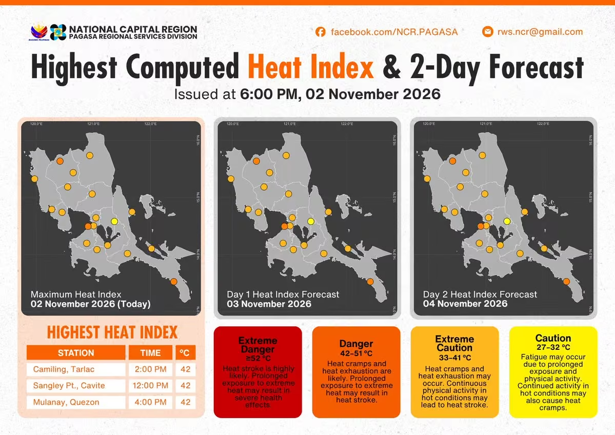
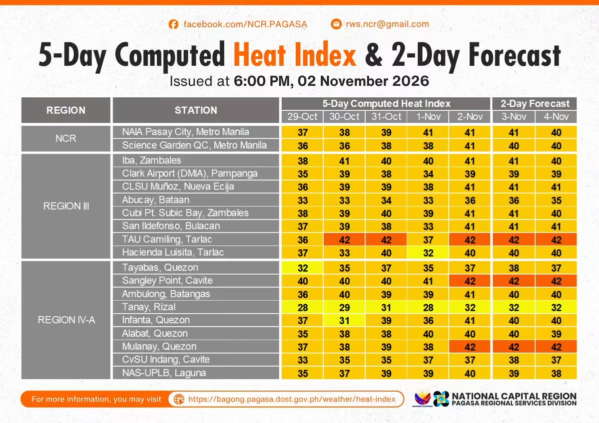
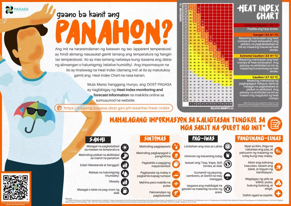
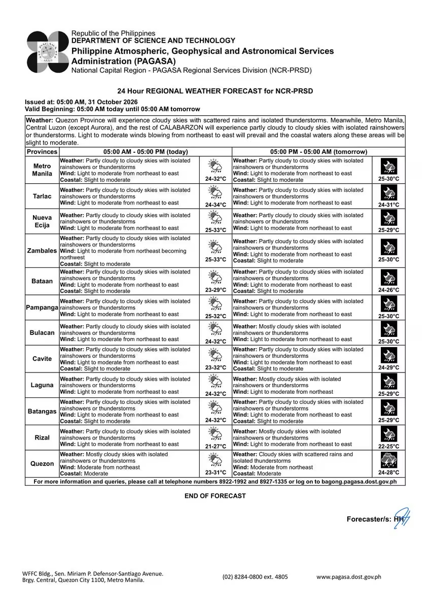
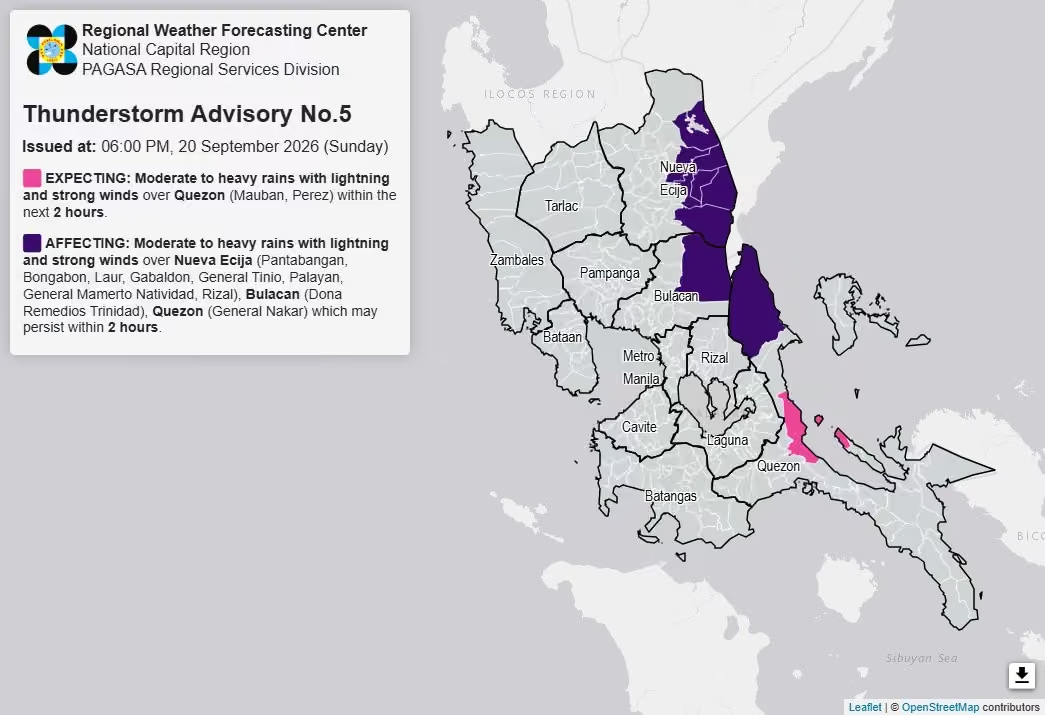
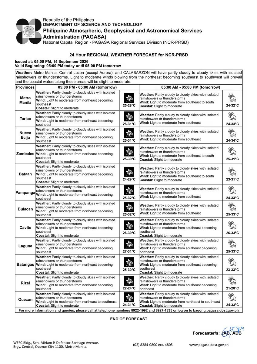
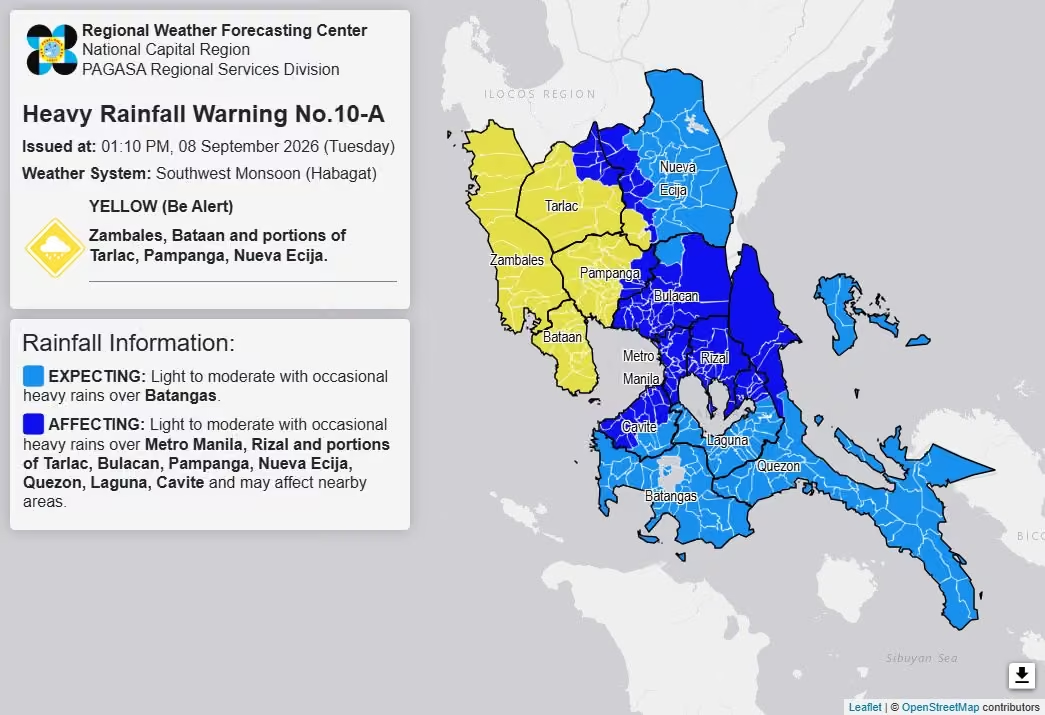
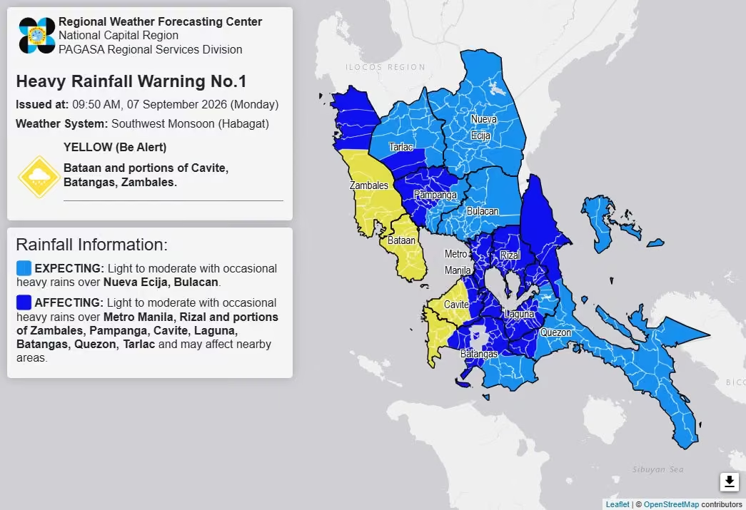
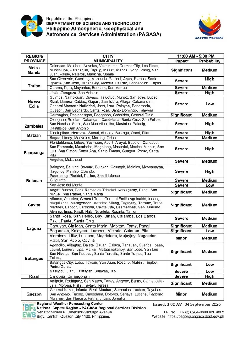
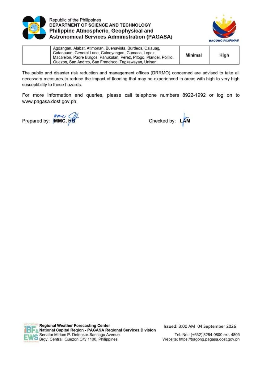
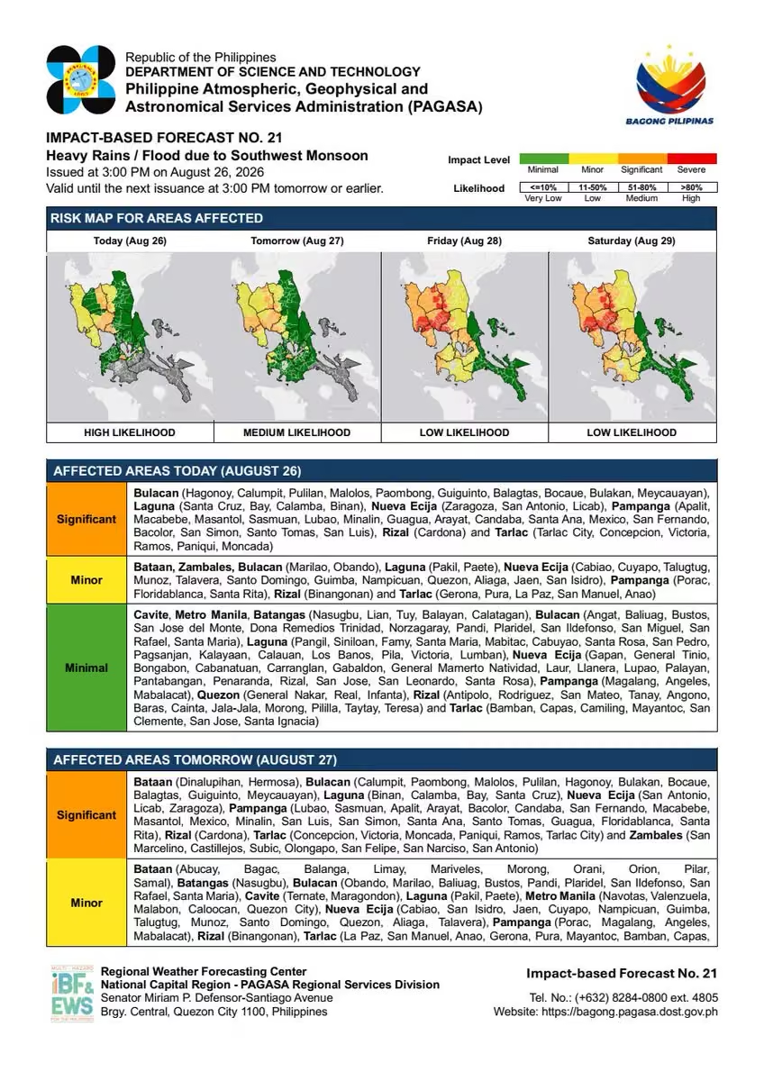
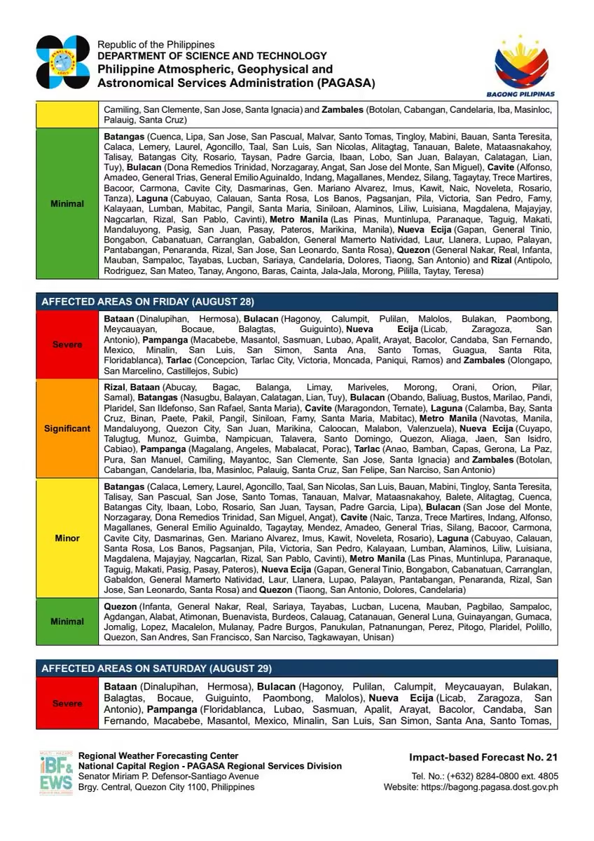
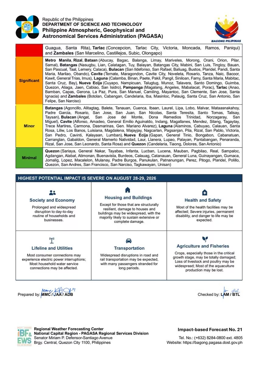
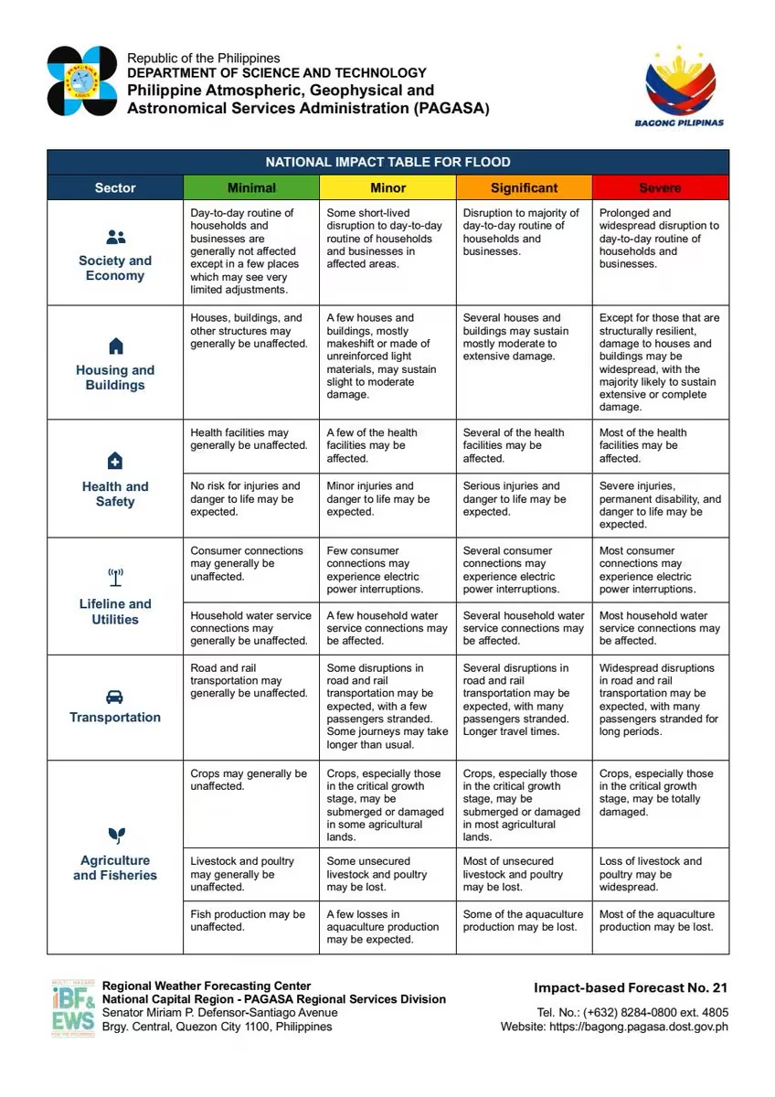
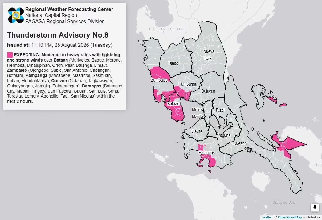
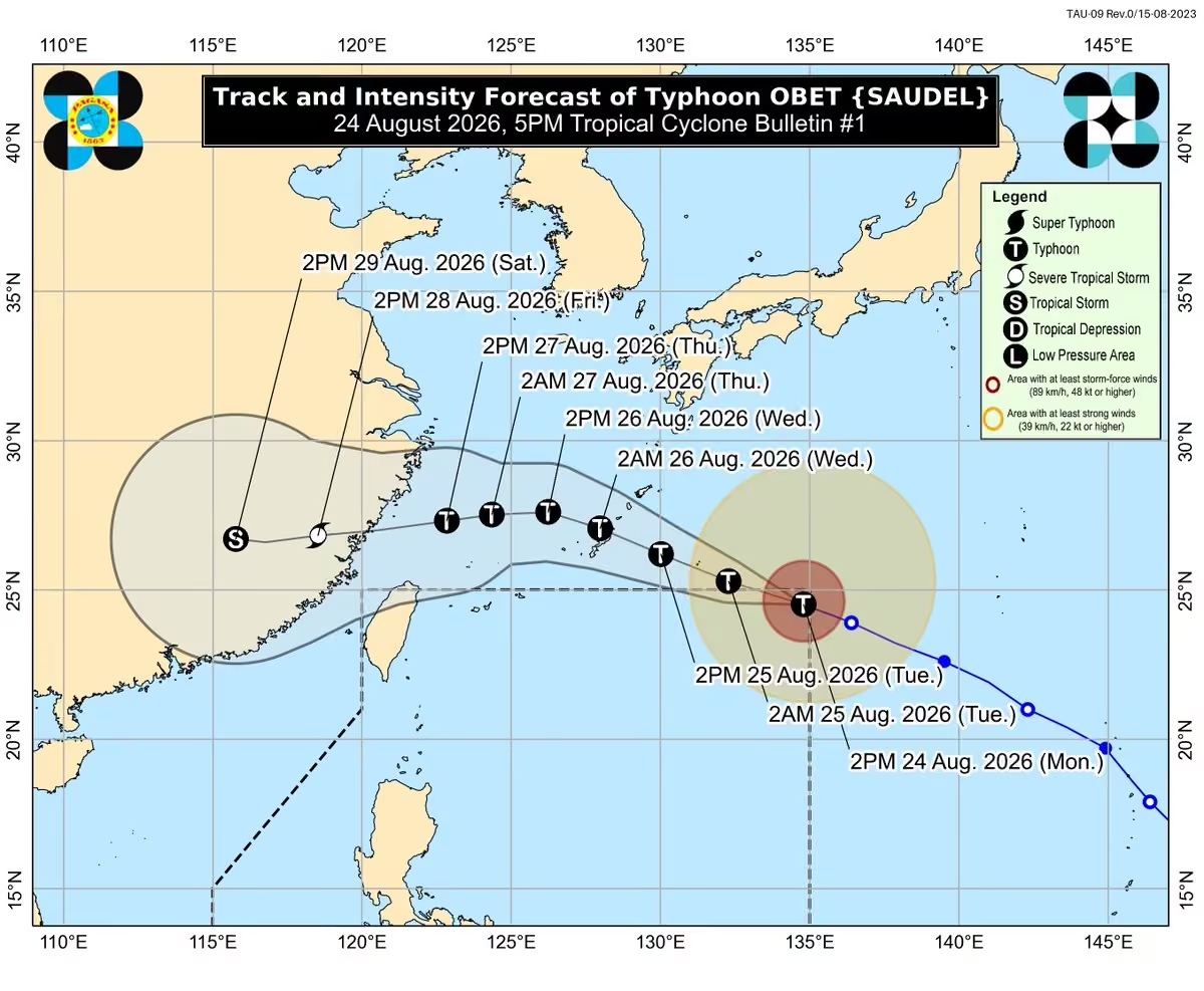
5-Day Highest Computed Heat Index and 2-Day Forecast
Issued at: 6:00 PM, 17 November 2026
You may access the information using this link:
www.pagasa.dost.gov.ph/weather/heat-index
PAGASA
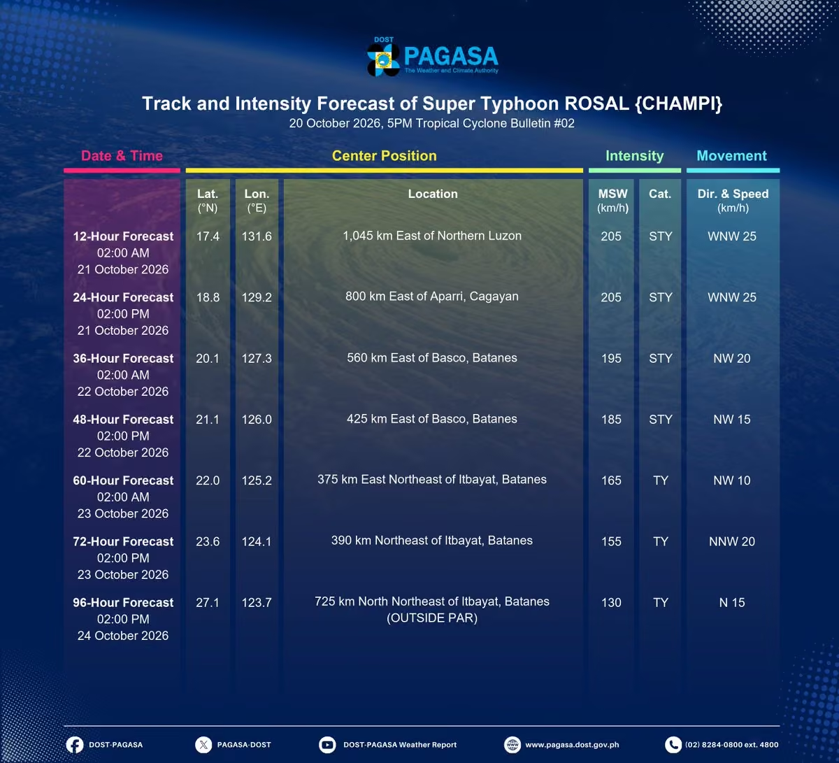
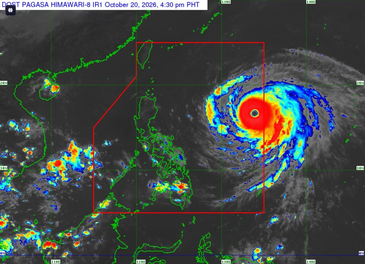
The Philippine Atmospheric, Geophysical and Astronomical Services Administration (Filipino: Pangasiwaan ng Pilipinas sa Serbisyong Atmosperiko, Heopisiko at Astronomiko), abbreviated as PAGASA, is the national meteorological and hydrological services (NMHS) agency of the Philippines. It is mandated to provide protection against natural calamities, ensure the safety, well-being, and economic security of the people, and promote national progress through scientific and technological services in meteorology, hydrology, climatology, astronomy, and other geophysical sciences. Created on December 8, 1972, through the reorganization of the Weather Bureau, PAGASA is one of the scientific and technological service institutes of the Department of Science and Technology. More on Wikipedia
-
PAGASA-DOST
@dost_pagasa
-
PAGASA-DOST
@dost_pagasa
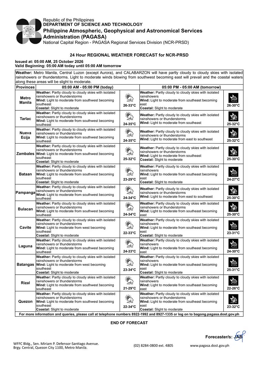
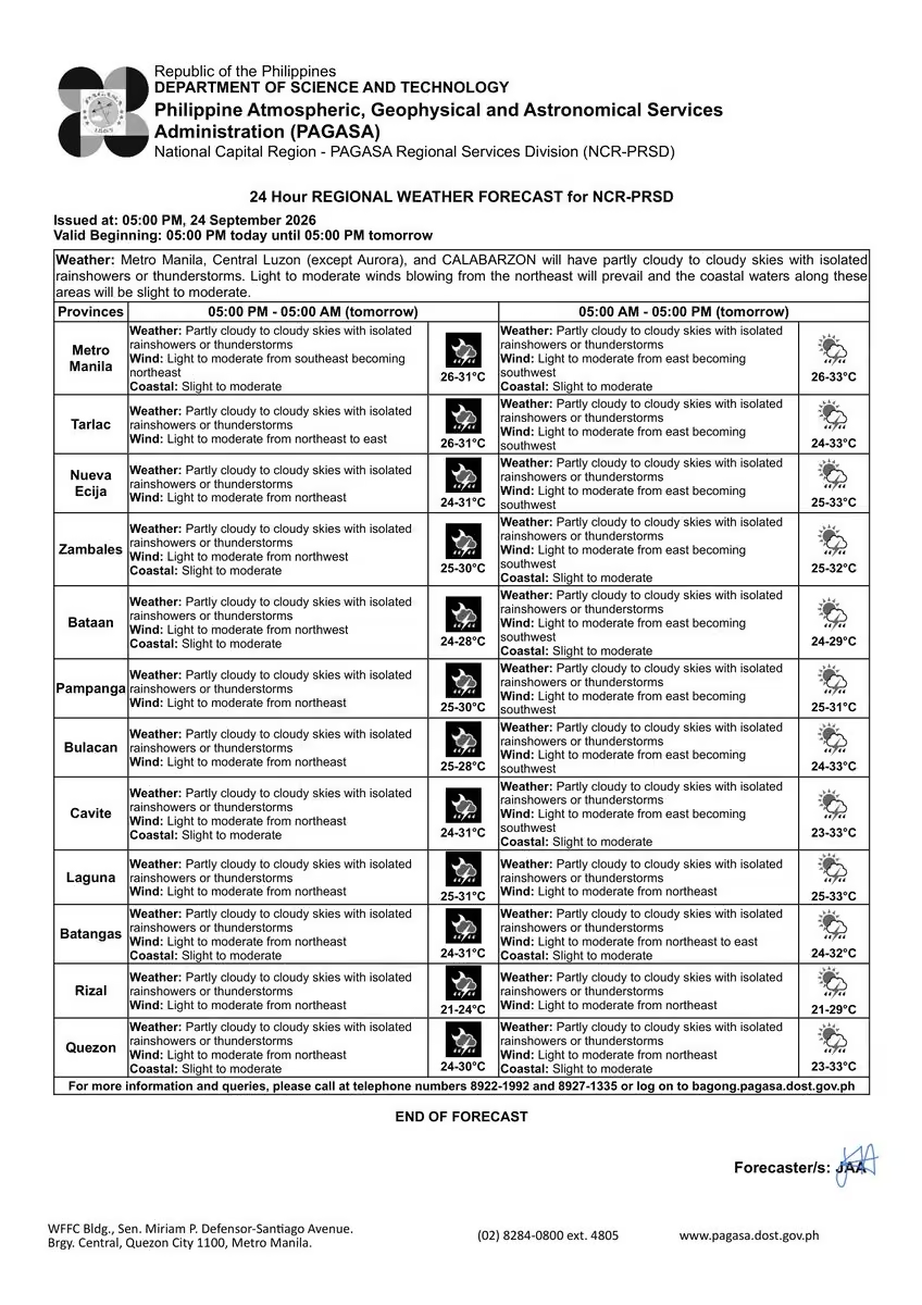
REGIONAL WEATHER FORECAST for #ncr_prsd
Issued at: 5:00 PM, 17 November 2026
Valid Beginning: 5:00 PM today - 5:00 PM tomorrow
www.pagasa.dost.gov.ph/regional-forecast/ncrprsd
***Help us improve our service by answering this quick survey.
Kindly follow this link: docs.google.com/forms/d/e/1FAIpQLSfqE28lYSNaQt7-z-0wRtwqv… -
PAGASA-DOST
@dost_pagasa
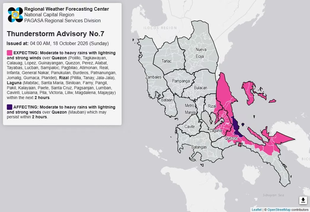
Thunderstorm Information #ncr_prsd
Issued at: 10:00 AM, 17 November 2026
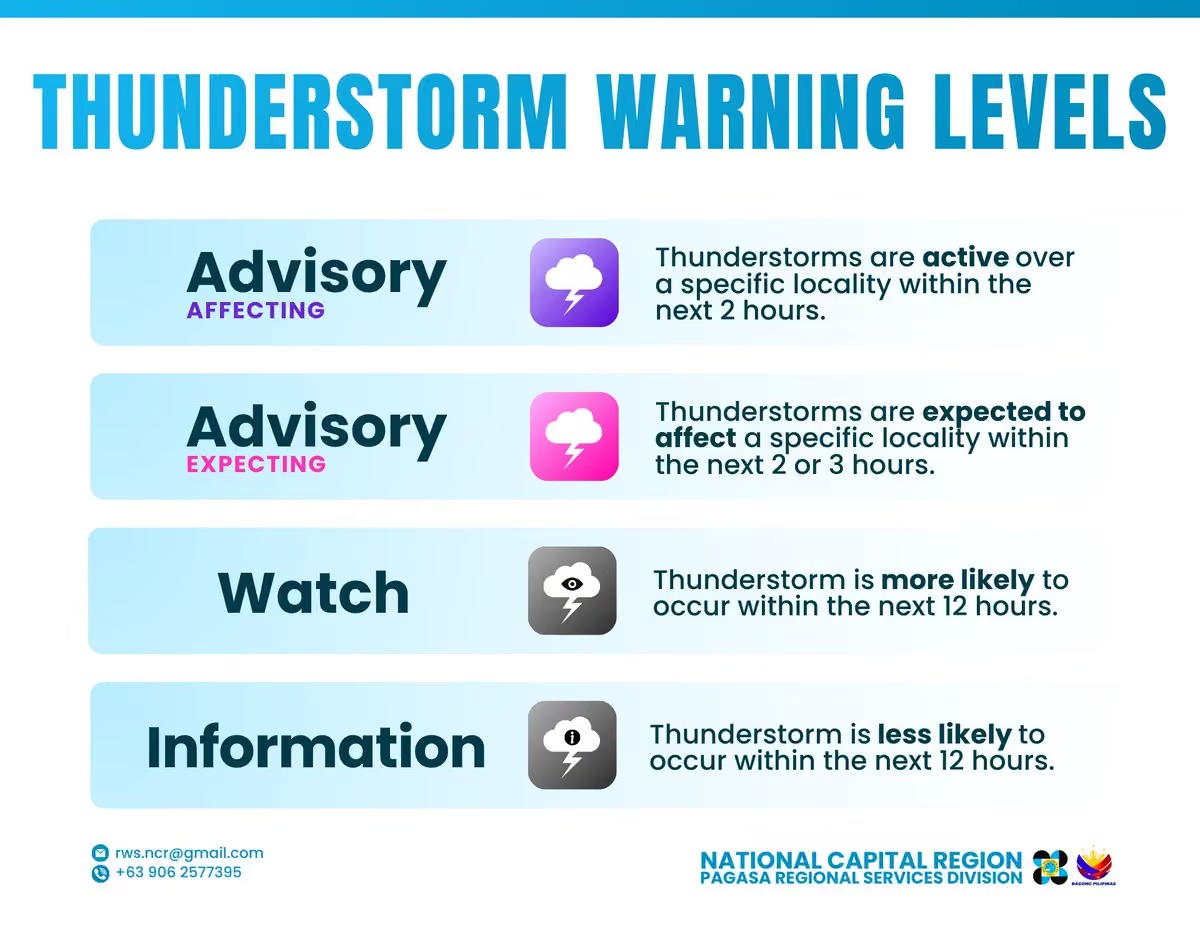
Thunderstorm is LESS LIKELY to develop over Greater Metro Manila Area(Metro Manila, Bulacan, Rizal, Laguna and Cavite) within 12 hours.
All are advised to continue monitoring for updates. -
PAGASA-DOST
@dost_pagasa
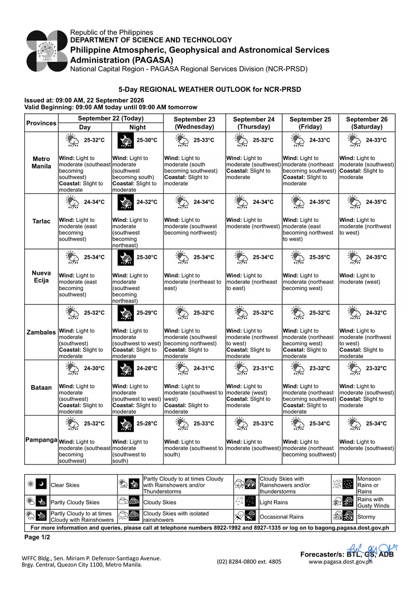
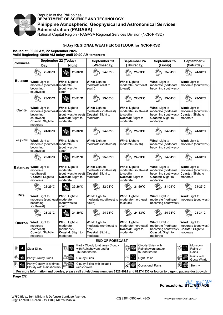
5-DAY REGIONAL WEATHER OUTLOOK for #ncr_prsd
Issued at: 9:00 AM, 17 November 2026
Valid Beginning: 9:00 AM today - 9:00 AM tomorrow
www.pagasa.dost.gov.ph/regional-forecast/ncrprsd
***Help us improve our service by answering this quick survey.
Kindly follow this link: docs.google.com/forms/d/e/1FAIpQLSfqE28lYSNaQt7-z-0wRtwqv… -
PAGASA-DOST
@dost_pagasa
REGIONAL WEATHER FORECAST for #ncr_prsd
Issued at: 5:00 AM, 17 November 2026
Valid Beginning: 5:00 AM today - 5:00 AM tomorrow
www.pagasa.dost.gov.ph/regional-forecast/ncrprsd
***Help us improve our service by answering this quick survey.
Kindly follow this link: docs.google.com/forms/d/e/1FAIpQLSfqE28lYSNaQt7-z-0wRtwqv… -
PAGASA-DOST
@dost_pagasa
REGIONAL WEATHER FORECAST for GREATER METRO MANILA AREA (GMMA) #ncr_prsd
Issued at: 4:00 AM, 17 November 2026
Valid Beginning: 4:00 AM - 10:00 AM today
www.pagasa.dost.gov.ph/regional-forecast/ncrprsd -
PAGASA-DOST
@dost_pagasa
5-Day Highest Computed Heat Index and 2-Day Forecast
Issued at: 6:00 PM, 16 November 2026
You may access the information using this link:
www.pagasa.dost.gov.ph/weather/heat-index -
PAGASA-DOST
@dost_pagasa
REGIONAL WEATHER FORECAST for #ncr_prsd
Issued at: 5:00 PM, 16 November 2026
Valid Beginning: 5:00 PM today - 5:00 PM tomorrow
www.pagasa.dost.gov.ph/regional-forecast/ncrprsd
***Help us improve our service by answering this quick survey.
Kindly follow this link: docs.google.com/forms/d/e/1FAIpQLSfqE28lYSNaQt7-z-0wRtwqv… -
PAGASA-DOST
@dost_pagasa
Thunderstorm Information #ncr_prsd
Issued at: 10:00 AM, 16 November 2026
Thunderstorm is LESS LIKELY to develop over Greater Metro Manila Area(Metro Manila, Bulacan, Rizal, Laguna and Cavite) within 12 hours.
All are advised to continue monitoring for updates. -
PAGASA-DOST
@dost_pagasa
5-DAY REGIONAL WEATHER OUTLOOK for #ncr_prsd
Issued at: 9:00 AM, 16 November 2026
Valid Beginning: 9:00 AM today - 9:00 AM tomorrow
www.pagasa.dost.gov.ph/regional-forecast/ncrprsd
***Help us improve our service by answering this quick survey.
Kindly follow this link: docs.google.com/forms/d/e/1FAIpQLSfqE28lYSNaQt7-z-0wRtwqv… -
PAGASA-DOST
@dost_pagasa
REGIONAL WEATHER FORECAST for GREATER METRO MANILA AREA (GMMA) #ncr_prsd
Issued at: 4:00 AM, 16 November 2026
Valid Beginning: 4:00 AM - 10:00 AM today
www.pagasa.dost.gov.ph/regional-forecast/ncrprsd -
PAGASA-DOST
@dost_pagasa
Thunderstorm Information #ncr_prsd
Issued at: 10:00 PM, 15 November 2026
Thunderstorm is LESS LIKELY to develop over Greater Metro Manila Area(Metro Manila, Bulacan, Rizal, Laguna and Cavite) within 12 hours.
All are advised to continue monitoring for updates. -
PAGASA-DOST
@dost_pagasa
5-Day Highest Computed Heat Index and 2-Day Forecast
Issued at: 6:00 PM, 15 November 2026
You may access the information using this link:
www.pagasa.dost.gov.ph/weather/heat-index -
PAGASA-DOST
@dost_pagasa
REGIONAL WEATHER FORECAST for #ncr_prsd
Issued at: 5:00 PM, 15 November 2026
Valid Beginning: 5:00 PM today - 5:00 PM tomorrow
www.pagasa.dost.gov.ph/regional-forecast/ncrprsd
***Help us improve our service by answering this quick survey.
Kindly follow this link: docs.google.com/forms/d/e/1FAIpQLSfqE28lYSNaQt7-z-0wRtwqv… -
PAGASA-DOST
@dost_pagasa
Thunderstorm Watch #ncr_prsd
Issued at: 10:00 AM, 15 November 2026
Thunderstorm is MORE LIKELY to develop over Greater Metro Manila Area(Metro Manila, Bulacan, Rizal, Laguna and Cavite) within 12 hours.
All are advised to continue monitoring for updates. -
PAGASA-DOST
@dost_pagasa
5-DAY REGIONAL WEATHER OUTLOOK for #ncr_prsd
Issued at: 9:00 AM, 15 November 2026
Valid Beginning: 9:00 AM today - 9:00 AM tomorrow
www.pagasa.dost.gov.ph/regional-forecast/ncrprsd
***Help us improve our service by answering this quick survey.
Kindly follow this link: docs.google.com/forms/d/e/1FAIpQLSfqE28lYSNaQt7-z-0wRtwqv… -
PAGASA-DOST
@dost_pagasa
REGIONAL WEATHER FORECAST for #ncr_prsd
Issued at: 5:00 AM, 15 November 2026
Valid Beginning: 5:00 AM today - 5:00 AM tomorrow
www.pagasa.dost.gov.ph/regional-forecast/ncrprsd
***Help us improve our service by answering this quick survey.
Kindly follow this link: docs.google.com/forms/d/e/1FAIpQLSfqE28lYSNaQt7-z-0wRtwqv… -
PAGASA-DOST
@dost_pagasa
REGIONAL WEATHER FORECAST for GREATER METRO MANILA AREA (GMMA) #ncr_prsd
Issued at: 4:00 AM, 15 November 2026
Valid Beginning: 4:00 AM - 10:00 AM today
www.pagasa.dost.gov.ph/regional-forecast/ncrprsd -
PAGASA-DOST
@dost_pagasa
Thunderstorm Information #ncr_prsd
Issued at: 10:00 PM, 14 November 2026
Thunderstorm is LESS LIKELY to develop over Greater Metro Manila Area(Metro Manila, Bulacan, Rizal, Laguna and Cavite) within 12 hours.
All are advised to continue monitoring for updates. -
PAGASA-DOST
@dost_pagasa
5-Day Highest Computed Heat Index and 2-Day Forecast
Issued at: 6:00 PM, 14 November 2026
You may access the information using this link:
www.pagasa.dost.gov.ph/weather/heat-index -
PAGASA-DOST
@dost_pagasa
REGIONAL WEATHER FORECAST for #ncr_prsd
Issued at: 5:00 PM, 14 November 2026
Valid Beginning: 5:00 PM today - 5:00 PM tomorrow
www.pagasa.dost.gov.ph/regional-forecast/ncrprsd
***Help us improve our service by answering this quick survey.
Kindly follow this link: docs.google.com/forms/d/e/1FAIpQLSfqE28lYSNaQt7-z-0wRtwqv… -
PAGASA-DOST
@dost_pagasa
Thunderstorm Advisory No. 2 #ncr_prsd
Issued at: 2:58 PM, 14 November 2026(Saturday)
Moderate to heavy rainshowers with lightning and strong winds are expected over Bataan (Mariveles, Limay, and Orion), Cavite (Tanza, General Trias, Rosario, Noveleta, Cavite City, Kawit, Bacoor, Imus, Carmona, Gen. Mariano Alvarez, Dasmarinas, and Naic), Laguna (San Pedro, Binan, and Santa Rosa), Metro Manila (Taguig, Pasig, Muntinlupa, Las Pinas, Paranaque, Makati, Pasay, Pateros, Mandaluyong, Manila, San Juan, Quezon City, and Marikina), and Rizal (Binangonan, Angono, Cainta, Taytay, Antipolo, Teresa, and San Mateo) within the next 2 hours.
All are advised to take precautionary measures against the impacts associated with these hazards which include flash floods and landslides.
Keep monitoring for updates. -
PAGASA-DOST
@dost_pagasa
Thunderstorm Advisory No. 1 #ncr_prsd
Issued at: 1:00 PM, 14 November 2026(Saturday)
Moderate to heavy rainshowers with lightning and strong winds are expected over Cavite (Dasmarinas, Imus, Bacoor, General Trias, Tanza, Rosario, Kawit, Noveleta, Cavite City, Carmona, Gen. Mariano Alvarez, and Trece Martires), Laguna (San Pedro and Binan), Metro Manila (Muntinlupa, Las Pinas, Taguig, Paranaque, Pasay, Pasig, Makati, and Pateros), and Rizal (Tanay, Baras, Morong, Cardona, Teresa, Binangonan, Angono, Antipolo, Taytay, Cainta, and San Mateo) within the next 2 hours.
All are advised to take precautionary measures against the impacts associated with these hazards which include flash floods and landslides.
Keep monitoring for updates. -
PAGASA-DOST
@dost_pagasa
Thunderstorm Watch #ncr_prsd
Issued at: 10:00 AM, 14 November 2026
Thunderstorm is MORE LIKELY to develop over Greater Metro Manila Area(Metro Manila, Bulacan, Rizal, Laguna and Cavite) within 12 hours.
All are advised to continue monitoring for updates. -
PAGASA-DOST
@dost_pagasa
5-DAY REGIONAL WEATHER OUTLOOK for #ncr_prsd
Issued at: 9:00 AM, 14 November 2026
Valid Beginning: 9:00 AM today - 9:00 AM tomorrow
www.pagasa.dost.gov.ph/regional-forecast/ncrprsd
***Help us improve our service by answering this quick survey.
Kindly follow this link: docs.google.com/forms/d/e/1FAIpQLSfqE28lYSNaQt7-z-0wRtwqv… -
PAGASA-DOST
@dost_pagasa
REGIONAL WEATHER FORECAST for #ncr_prsd
Issued at: 5:00 AM, 14 November 2026
Valid Beginning: 5:00 AM today - 5:00 AM tomorrow
www.pagasa.dost.gov.ph/regional-forecast/ncrprsd
***Help us improve our service by answering this quick survey.
Kindly follow this link: docs.google.com/forms/d/e/1FAIpQLSfqE28lYSNaQt7-z-0wRtwqv… -
PAGASA-DOST
@dost_pagasa
REGIONAL WEATHER FORECAST for GREATER METRO MANILA AREA (GMMA) #ncr_prsd
Issued at: 4:00 AM, 14 November 2026
Valid Beginning: 4:00 AM - 10:00 AM today
www.pagasa.dost.gov.ph/regional-forecast/ncrprsd -
PAGASA-DOST
@dost_pagasa
Thunderstorm Advisory No. 2 #ncr_prsd
Issued at: 7:00 PM, 13 November 2026(Friday)
Moderate to heavy rainshowers with lightning and strong winds are expected over Quezon (Mulanay, San Narciso, San Francisco, San Andres, and Catanauan) within the next 2 hours.
All are advised to take precautionary measures against the impacts associated with these hazards which include flash floods and landslides.
Keep monitoring for updates. -
PAGASA-DOST
@dost_pagasa
5-Day Highest Computed Heat Index and 2-Day Forecast
Issued at: 6:00 PM, 13 November 2026
You may access the information using this link:
www.pagasa.dost.gov.ph/weather/heat-index -
PAGASA-DOST
@dost_pagasa
REGIONAL WEATHER FORECAST for #ncr_prsd
Issued at: 5:00 PM, 13 November 2026
Valid Beginning: 5:00 PM today - 5:00 PM tomorrow
www.pagasa.dost.gov.ph/regional-forecast/ncrprsd
***Help us improve our service by answering this quick survey.
Kindly follow this link: docs.google.com/forms/d/e/1FAIpQLSfqE28lYSNaQt7-z-0wRtwqv… -
PAGASA-DOST
@dost_pagasa
Thunderstorm Advisory No. 1 #ncr_prsd
Issued at: 4:35 PM, 13 November 2026(Friday)
Moderate to heavy rainshowers with lightning and strong winds are expected over Quezon (San Francisco and San Andres) within the next 2 hours.
All are advised to take precautionary measures against the impacts associated with these hazards which include flash floods and landslides.
Keep monitoring for updates. -
PAGASA-DOST
@dost_pagasa
5-DAY REGIONAL WEATHER OUTLOOK for #ncr_prsd
Issued at: 9:00 AM, 13 November 2026
Valid Beginning: 9:00 AM today - 9:00 AM tomorrow
www.pagasa.dost.gov.ph/regional-forecast/ncrprsd
***Help us improve our service by answering this quick survey.
Kindly follow this link: docs.google.com/forms/d/e/1FAIpQLSfqE28lYSNaQt7-z-0wRtwqv… -
PAGASA-DOST
@dost_pagasa
REGIONAL WEATHER FORECAST for #ncr_prsd
Issued at: 5:00 AM, 13 November 2026
Valid Beginning: 5:00 AM today - 5:00 AM tomorrow
www.pagasa.dost.gov.ph/regional-forecast/ncrprsd
***Help us improve our service by answering this quick survey.
Kindly follow this link: docs.google.com/forms/d/e/1FAIpQLSfqE28lYSNaQt7-z-0wRtwqv… -
PAGASA-DOST
@dost_pagasa
REGIONAL WEATHER FORECAST for GREATER METRO MANILA AREA (GMMA) #ncr_prsd
Issued at: 4:00 AM, 13 November 2026
Valid Beginning: 4:00 AM - 10:00 AM today
www.pagasa.dost.gov.ph/regional-forecast/ncrprsd -
PAGASA-DOST
@dost_pagasa
Rainfall Advisory No. 21-Final #ncr_prsd
Weather System: Easterlies
Issued at: 8:00 PM, 12 November 2026(Thursday)
All Rainfall Advisory over NCR-PRSD forecast area are now TERMINATED.
The public and the Disaster Risk Reduction and Management Offices concerned are still advised to MONITOR the weather condition.
For more information and queries, please call telephone numbers 8927-1335 and 8927-2877 or log on to www.pagasa.dost.gov.ph. -

PAGASA-DOST
@dost_pagasa
5-Day Highest Computed Heat Index and 2-Day Forecast
Issued at: 6:00 PM, 12 November 2026
You may access the information using this link:
www.pagasa.dost.gov.ph/weather/heat-index -
PAGASA-DOST
@dost_pagasa
REGIONAL WEATHER FORECAST for #ncr_prsd
Issued at: 5:00 PM, 12 November 2026
Valid Beginning: 5:00 PM today - 5:00 PM tomorrow
www.pagasa.dost.gov.ph/regional-forecast/ncrprsd
***Help us improve our service by answering this quick survey.
Kindly follow this link: docs.google.com/forms/d/e/1FAIpQLSfqE28lYSNaQt7-z-0wRtwqv… -
PAGASA-DOST
@dost_pagasa
Rainfall Advisory No. 20 #ncr_prsd
Weather System: Easterlies
Issued at: 5:00 PM, 12 November 2026(Thursday)
Light to moderate rains are expected over Quezon(Panukulan, Burdeos, Patnanungan, Jomalig, Polillo, Infanta, Mauban, Real, Sampaloc, Alabat, Atimonan, Buenavista, Calauag, Guinayangan, Gumaca, Lopez, Perez, Plaridel, Quezon, Tagkawayan, General Nakar).
The public and the Disaster Risk Reduction and Management Offices concerned are advised to MONITOR the weather condition and watch for the next warning to be issued at 8:00 PM today.
For more information and queries, please call telephone numbers 8927-1335 and 8927-2877 or log on to www.pagasa.dost.gov.ph. -
PAGASA-DOST
@dost_pagasa
Rainfall Advisory No. 19 #ncr_prsd
Weather System: Easterlies
Issued at: 2:00 PM, 12 November 2026(Thursday)
Light to moderate with occasional heavy rains are expected over Laguna(Santa Maria, Siniloan, Famy, Pangil, Pakil, Paete, Lumban, Kalayaan, Cavinti, Luisiana, Majayjay, Magdalena, Pagsanjan, Mabitac, Santa Cruz), Rizal(Tanay, Rodriguez, Antipolo, Pililla, Jala-Jala, Baras) and Bulacan(Dona Remedios Trinidad, Norzagaray).
Light to moderate with occasional heavy rains affecting Quezon(Polillo, Burdeos, Panukulan, Patnanungan, Jomalig, Tagkawayan, Guinayangan, Lopez, Catanauan, Buenavista, General Luna, Mauban) and may affect nearby areas.
The public and the Disaster Risk Reduction and Management Offices concerned are advised to MONITOR the weather condition and watch for the next warning to be issued at 5:00 PM today.
For more information and queries, please call telephone numbers 8927-1335 and 8927-2877 or log on to www.pagasa.dost.gov.ph. -
PAGASA-DOST
@dost_pagasa
Rainfall Advisory No. 18 #ncr_prsd
Weather System: Easterlies
Issued at: 11:00 AM, 12 November 2026(Thursday)
Light to moderate rains are expected over Bulacan(Dona Remedios Trinidad, Norzagaray), Laguna(Santa Maria, Pangil, Siniloan, Famy, Pakil, Paete, Kalayaan, Lumban, Cavinti, Luisiana, Majayjay, Mabitac) and Rizal(Rodriguez, Antipolo, Tanay).
Light to moderate with occasional heavy rains affecting Quezon(Polillo, Burdeos, Panukulan, Patnanungan, Jomalig, Calauag, Tagkawayan, Guinayangan, Quezon, Alabat, Perez, San Narciso, Buenavista) and may affect nearby areas.
The public and the Disaster Risk Reduction and Management Offices concerned are advised to MONITOR the weather condition and watch for the next warning to be issued at 2:00 PM today.
For more information and queries, please call telephone numbers 8927-1335 and 8927-2877 or log on to www.pagasa.dost.gov.ph. -
PAGASA-DOST
@dost_pagasa
Rainfall Advisory No. 17 #ncr_prsd
Weather System: Easterlies
Issued at: 8:00 AM, 12 November 2026(Thursday)
Light to moderate rains are expected over Laguna.
Light to moderate with occasional heavy rains affecting Quezon(General Nakar, Burdeos, Panukulan, Polillo, Patnanungan, Jomalig), Rizal(Antipolo, Rodriguez, San Mateo), Bulacan(Norzagaray, San Jose del Monte, San Rafael, San Ildefonso, Dona Remedios Trinidad, Angat, Marilao, Santa Maria, Bocaue, Pandi, Bustos, Meycauayan, Obando) and Metro Manila(Caloocan, Valenzuela, Navotas, Malabon, Quezon City, Marikina) and may affect nearby areas.
The public and the Disaster Risk Reduction and Management Offices concerned are advised to MONITOR the weather condition and watch for the next warning to be issued at 11:00 AM today.
For more information and queries, please call telephone numbers 8927-1335 and 8927-2877 or log on to www.pagasa.dost.gov.ph. -
PAGASA-DOST
@dost_pagasa
REGIONAL WEATHER FORECAST for #ncr_prsd
Issued at: 5:00 AM, 12 November 2026
Valid Beginning: 5:00 AM today - 5:00 AM tomorrow
www.pagasa.dost.gov.ph/regional-forecast/ncrprsd
***Help us improve our service by answering this quick survey.
Kindly follow this link: docs.google.com/forms/d/e/1FAIpQLSfqE28lYSNaQt7-z-0wRtwqv… -
PAGASA-DOST
@dost_pagasa
Rainfall Advisory No. 16 #ncr_prsd
Weather System: Easterlies
Issued at: 5:00 AM, 12 November 2026(Thursday)
Light to moderate rains are expected over Rizal(Tanay, Pililla, Jala-Jala, Antipolo, Baras, Binangonan, Cardona, Teresa, Morong).
Light to moderate rains affecting Quezon(Tagkawayan, Panukulan, Burdeos, Polillo, Patnanungan, Jomalig, Calauag, Mauban, Real, Sampaloc, Lucban, Tayabas, Pagbilao, Infanta) and Laguna(Cavinti, Pakil, Paete, Kalayaan, Lumban, Pangil, Siniloan) and may affect nearby areas.
The public and the Disaster Risk Reduction and Management Offices concerned are advised to MONITOR the weather condition and watch for the next warning to be issued at 8:00 AM today.
For more information and queries, please call telephone numbers 8927-1335 and 8927-2877 or log on to www.pagasa.dost.gov.ph. -
PAGASA-DOST
@dost_pagasa
REGIONAL WEATHER FORECAST for GREATER METRO MANILA AREA (GMMA) #ncr_prsd Issued at: 4:00 AM, 12 November 2026 Valid Beginning: 4:00 AM - 10:00 AM today www.pagasa.dost.gov.ph/regional-forecast/ncrprsd
-
PAGASA-DOST
@dost_pagasa
Rainfall Advisory No. 15 #ncr_prsd
Weather System: Northeast Monsoon (Amihan)
Issued at: 2:00 AM, 12 November 2026(Thursday)
Light to moderate rains are expected over Metro Manila(Quezon City, Marikina, Pasig, Taguig, Muntinlupa, Caloocan, Valenzuela, San Juan, Mandaluyong, Makati, Pateros), Batangas(Lipa, Santo Tomas, Padre Garcia, Tanauan, Malvar), Cavite(Carmona, Silang) and Bulacan(San Jose del Monte, Norzagaray, Marilao, Meycauayan, Dona Remedios Trinidad).
Light to moderate rains affecting Quezon(Panukulan, Burdeos, Polillo, Patnanungan, Jomalig, Tagkawayan, Perez, General Nakar, Infanta, Real, Mauban, Sampaloc, Atimonan, Pagbilao, Lucena, Tayabas, Lucban, Calauag), Rizal(Binangonan, Cardona, Jala-Jala, Pililla, Tanay, Morong, Baras, Rodriguez, San Mateo, Antipolo) and Laguna(San Pablo, Calauan) and may affect nearby areas.
The public and the Disaster Risk Reduction and Management Offices concerned are advised to MONITOR the weather condition and watch for the next warning to be issued at 5:00 AM today.
For more information and queries, please call telephone numbers 8927-1335 and 8927-2877 or log on to www.pagasa.dost.gov.ph. -
PAGASA-DOST
@dost_pagasa
Rainfall Advisory No. 14 #ncr_prsd
Weather System: Northeast Monsoon (Amihan)
Issued at: 11:00 PM, 11 November 2026(Wednesday)
Light to moderate rains are expected over Batangas(Tanauan, Santo Tomas, Malvar, Talisay, Balete, Lipa, Mataasnakahoy, Nasugbu, Laurel, Lian, Tuy) and Bulacan(Dona Remedios Trinidad, Norzagaray, San Jose del Monte).
Light to moderate rains affecting Quezon(Panukulan, Polillo, Burdeos, Patnanungan, Jomalig, Infanta, Real, General Nakar, Mauban, Tagkawayan, Guinayangan, Perez, Calauag), Rizal(Tanay, Morong, Baras, Binangonan, Pililla, Jala-Jala, Cardona), Laguna(Santa Maria, Siniloan, Mabitac, Pakil, Pangil, Famy, San Pedro, Binan, Santa Rosa, Cabuyao, Calamba, Paete), Cavite(Carmona, Gen. Mariano Alvarez, Imus, Dasmarinas, Bacoor, General Trias, Trece Martires, Tanza, Silang) and Metro Manila(Muntinlupa, Las Pinas) and may affect nearby areas.
The public and the Disaster Risk Reduction and Management Offices concerned are advised to MONITOR the weather condition and watch for the next warning to be issued at 2:00 AM tomorrow.
For more information and queries, please call telephone numbers 8927-1335 and 8927-2877 or log on to www.pagasa.dost.gov.ph. -
PAGASA-DOST
@dost_pagasa
Rainfall Advisory No. 13 #ncr_prsd
Weather System: Northeast Monsoon (Amihan)
Issued at: 8:00 PM, 11 November 2026(Wednesday)
Light to moderate rains are expected over Metro Manila(Pasig, Marikina, Taguig, Muntinlupa, Pateros, Paranaque, Las Pinas, Quezon City) and Batangas(Santo Tomas, Lipa).
Light to moderate rains affecting Quezon(Perez, Atimonan, Pagbilao, Tayabas, Lucena, Lucban, Sampaloc, Mauban, Panukulan, Burdeos, Patnanungan, Jomalig, Polillo, General Nakar, Infanta), Rizal(Tanay, Pililla, Binangonan, Angono, Taytay) and Laguna(Santa Maria, Alaminos, Calauan, Bay, San Pablo, Rizal, Nagcarlan, Los Banos, Victoria) and may affect nearby areas.
The public and the Disaster Risk Reduction and Management Offices concerned are advised to MONITOR the weather condition and watch for the next warning to be issued at 11:00 PM today.
For more information and queries, please call telephone numbers 8927-1335 and 8927-2877 or log on to www.pagasa.dost.gov.ph. -
PAGASA-DOST
@dost_pagasa
REGIONAL WEATHER FORECAST for #ncr_prsd
Issued at: 5:00 PM, 11 November 2026
Valid Beginning: 5:00 PM today - 5:00 PM tomorrow
www.pagasa.dost.gov.ph/regional-forecast/ncrprsd
***Help us improve our service by answering this quick survey.
Kindly follow this link: docs.google.com/forms/d/e/1FAIpQLSfqE28lYSNaQt7-z-0wRtwqv… -
PAGASA-DOST
@dost_pagasa
Rainfall Advisory No. 12 #ncr_prsd
Weather System: Northeast Monsoon (Amihan)
Issued at: 5:00 PM, 11 November 2026(Wednesday)
Light to moderate rains are expected over Bulacan(Norzagaray, San Jose del Monte, Dona Remedios Trinidad, Paombong, Malolos, Bulakan, Obando, Marilao, Meycauayan, Hagonoy), Nueva Ecija(General Tinio, Gabaldon), Metro Manila(Quezon City, Marikina, Pasig, Caloocan, Valenzuela, Manila, Navotas, Malabon, San Juan, Mandaluyong, Makati, Pateros, Taguig, Muntinlupa) and Batangas(Santo Tomas, Balete, Lipa, Malvar, Mataasnakahoy, Padre Garcia, Tanauan).
Light to moderate rains affecting Rizal(Cardona, Pililla, Jala-Jala, Binangonan), Laguna(Santa Maria, Mabitac, Pakil, Siniloan, Famy, Pangil) and Quezon(Infanta, Real, Tayabas, Sampaloc, Lucban, Mauban, Pagbilao, Perez, Lucena, Panukulan, Patnanungan, Burdeos, Polillo) and may affect nearby areas.
The public and the Disaster Risk Reduction and Management Offices concerned are advised to MONITOR the weather condition and watch for the next warning to be issued at 8:00 PM today.
For more information and queries, please call telephone numbers 8927-1335 and 8927-2877 or log on to www.pagasa.dost.gov.ph. -
PAGASA-DOST
@dost_pagasa
Rainfall Advisory No. 11 #ncr_prsd
Weather System: Northeast Monsoon (Amihan)
Issued at: 2:00 PM, 11 November 2026(Wednesday)
Light to moderate rains are expected over Cavite(Silang, Carmona, Gen. Mariano Alvarez, Dasmarinas, Amadeo, Tagaytay, Indang, General Trias, Trece Martires, Mendez, Alfonso), Batangas(Talisay, Lipa, Santo Tomas, Malvar, Tanauan, Balete, Mataasnakahoy, Laurel, Lemery, Agoncillo, Mabini, Bauan, San Luis, Taal, San Nicolas, Santa Teresita, Alitagtag, Cuenca, San Jose, San Pascual, Tingloy, Padre Garcia, Ibaan, Rosario, Batangas City, San Juan, Taysan, Lobo), Bulacan(Norzagaray, Dona Remedios Trinidad) and Nueva Ecija(General Tinio, Gabaldon).
Light to moderate rains affecting Rizal(Tanay, Pililla, Jala-Jala), Quezon(General Nakar, Mauban, Infanta, Real, Panukulan, Burdeos, Polillo, Patnanungan, Jomalig, Quezon, Alabat, Perez, Gumaca, Plaridel, Atimonan, Lucban, Sampaloc, Tagkawayan) and Laguna(Pila, Santa Cruz, Santa Maria, Famy, Siniloan, Pangil, Pakil, Paete, Kalayaan, Lumban, Cavinti, Pagsanjan, Mabitac, Bay, Cabuyao, Calauan, Calamba, Los Banos, Victoria) and may affect nearby areas.
The public and the Disaster Risk Reduction and Management Offices concerned are advised to MONITOR the weather condition and watch for the next warning to be issued at 5:00 PM today.
For more information and queries, please call telephone numbers 8927-1335 and 8927-2877 or log on to www.pagasa.dost.gov.ph. -
PAGASA-DOST
@dost_pagasa
5-DAY REGIONAL WEATHER OUTLOOK for #ncr_prsd
Issued at: 9:00 AM, 11 November 2026
Valid Beginning: 9:00 AM today - 9:00 AM tomorrow
www.pagasa.dost.gov.ph/regional-forecast/ncrprsd
***Help us improve our service by answering this quick survey.
Kindly follow this link: docs.google.com/forms/d/e/1FAIpQLSfqE28lYSNaQt7-z-0wRtwqv… -
PAGASA-DOST
@dost_pagasa
Rainfall Advisory No. 9 #ncr_prsd
Weather System: Northeast Monsoon (Amihan)
Issued at: 8:00 AM, 11 November 2026(Wednesday)
Light to moderate rains are expected over Rizal(Tanay, Pililla, Jala-Jala, Rodriguez, Antipolo, Baras) and Bulacan(Dona Remedios Trinidad, Norzagaray).
Light to moderate rains affecting Quezon(Burdeos, Polillo, Panukulan, Patnanungan, Jomalig, Perez, Alabat, Calauag, Real, Mauban, Sampaloc) and Laguna(Cavinti, Lumban, Kalayaan, Paete, Pakil, Pangil, Siniloan) and may affect nearby areas.
The public and the Disaster Risk Reduction and Management Offices concerned are advised to MONITOR the weather condition and watch for the next warning to be issued at 11:00 AM today.
For more information and queries, please call telephone numbers 8927-1335 and 8927-2877 or log on to www.pagasa.dost.gov.ph. -
PAGASA-DOST
@dost_pagasa
Rainfall Advisory No. 8 #ncr_prsd
Weather System: Northeast Monsoon (Amihan)
Issued at: 5:00 AM, 11 November 2026(Wednesday)
Light to moderate rains are expected over Laguna(Luisiana, Cavinti, Majayjay, Liliw, Nagcarlan, Rizal, Siniloan, Santa Maria, Famy, Pangil, Pakil, Paete, Kalayaan, Lumban, Pagsanjan, Magdalena, Santa Cruz, Pila, Victoria, San Pablo, Mabitac).
Light to moderate rains affecting Quezon(Panukulan, Burdeos, Polillo, Patnanungan, Jomalig, Mauban, Sampaloc, Lucban, Tayabas, Candelaria, Sariaya) and may affect nearby areas.
The public and the Disaster Risk Reduction and Management Offices concerned are advised to MONITOR the weather condition and watch for the next warning to be issued at 8:00 AM today.
For more information and queries, please call telephone numbers 8927-1335 and 8927-2877 or log on to www.pagasa.dost.gov.ph. -
PAGASA-DOST
@dost_pagasa
REGIONAL WEATHER FORECAST for #ncr_prsd
Issued at: 5:00 AM, 11 November 2026
Valid Beginning: 5:00 AM today - 5:00 AM tomorrow
www.pagasa.dost.gov.ph/regional-forecast/ncrprsd
***Help us improve our service by answering this quick survey.
Kindly follow this link: docs.google.com/forms/d/e/1FAIpQLSfqE28lYSNaQt7-z-0wRtwqv… -
PAGASA-DOST
@dost_pagasa
REGIONAL WEATHER FORECAST for GREATER METRO MANILA AREA (GMMA) #ncr_prsd
Issued at: 4:00 AM, 11 November 2026
Valid Beginning: 4:00 AM - 10:00 AM today
www.pagasa.dost.gov.ph/regional-forecast/ncrprsd -
PAGASA-DOST
@dost_pagasa
Rainfall Advisory No. 7 #ncr_prsd
Weather System: Northeast Monsoon (Amihan)
Issued at: 2:00 AM, 11 November 2026(Wednesday)
Light to moderate rains affecting Quezon(Polillo, Burdeos, Patnanungan, Jomalig, Infanta, General Nakar, Real, Panukulan, Mauban, Perez, Calauag, Alabat), Rizal(Tanay, Pililla, Cardona, Binangonan, Morong, Baras, Jala-Jala) and Laguna(Mabitac, Santa Maria, Famy, Pakil, Siniloan, Pangil) and may affect nearby areas.
The public and the Disaster Risk Reduction and Management Offices concerned are advised to MONITOR the weather condition and watch for the next warning to be issued at 5:00 AM today.
For more information and queries, please call telephone numbers 8927-1335 and 8927-2877 or log on to www.pagasa.dost.gov.ph. -
PAGASA-DOST
@dost_pagasa
Rainfall Advisory No. 6 #ncr_prsd
Weather System: Northeast Monsoon (Amihan)
Issued at: 11:00 PM, 10 November 2026(Tuesday)
Light to moderate rains are expected over Rizal(Tanay, Jala-Jala, Pililla, Cardona, Binangonan, Baras) and Batangas(San Juan).
Light to moderate rains affecting Quezon(Perez, Quezon, Calauag, Alabat, Sariaya, Lucena, Tayabas, Mauban, Pagbilao, Atimonan, Padre Burgos, Agdangan, Sampaloc, Lucban, Polillo, Patnanungan, Jomalig) and Laguna(Luisiana, Cavinti) and may affect nearby areas.
The public and the Disaster Risk Reduction and Management Offices concerned are advised to MONITOR the weather condition and watch for the next warning to be issued at 2:00 AM tomorrow.
For more information and queries, please call telephone numbers 8927-1335 and 8927-2877 or log on to www.pagasa.dost.gov.ph. -
PAGASA-DOST
@dost_pagasa
Rainfall Advisory No. 5 #ncr_prsd
Weather System: Northeast Monsoon (Amihan)
Issued at: 8:00 PM, 10 November 2026(Tuesday)
Light to moderate rains are expected over Rizal(Tanay).
Light to moderate rains affecting Quezon(Tagkawayan, Calauag, Quezon, Perez, Alabat, Patnanungan, Jomalig, Polillo, Burdeos, Panukulan, Mauban, Atimonan, Guinayangan, Pagbilao, Tayabas, Lucban, Sampaloc, San Narciso, Mulanay, San Andres, San Francisco, Buenavista) and Laguna(Famy, Santa Maria, Pangil, Siniloan, Pakil, Mabitac) and may affect nearby areas.
The public and the Disaster Risk Reduction and Management Offices concerned are advised to MONITOR the weather condition and watch for the next warning to be issued at 11:00 PM today.
For more information and queries, please call telephone numbers 8927-1335 and 8927-2877 or log on to www.pagasa.dost.gov.ph. -
PAGASA-DOST
@dost_pagasa
5-Day Highest Computed Heat Index and 2-Day Forecast
Issued at: 6:00 PM, 10 November 2026
You may access the information using this link:
www.pagasa.dost.gov.ph/weather/heat-index -
PAGASA-DOST
@dost_pagasa
REGIONAL WEATHER FORECAST for #ncr_prsd
Issued at: 5:00 PM, 10 November 2026
Valid Beginning: 5:00 PM today - 5:00 PM tomorrow
www.pagasa.dost.gov.ph/regional-forecast/ncrprsd
***Help us improve our service by answering this quick survey.
Kindly follow this link: docs.google.com/forms/d/e/1FAIpQLSfqE28lYSNaQt7-z-0wRtwqv… -
PAGASA-DOST
@dost_pagasa
Rainfall Advisory No. 4 #ncr_prsd
Weather System: Northeast Monsoon (Amihan)
Issued at: 5:00 PM, 10 November 2026(Tuesday)
Light to moderate rains are expected over Laguna(Luisiana, Cavinti, Kalayaan, Paete, Lumban, Pakil, Pangil, Siniloan, Santa Maria, Famy, Mabitac, Santa Cruz, Pila, Calauan, Los Banos, Victoria, Nagcarlan, Magdalena, Liliw, Pagsanjan, Bay, Rizal, Majayjay, Calamba, Cabuyao) and Rizal(Tanay, Pililla, Jala-Jala, Cardona, Binangonan).
Light to moderate rains affecting Quezon(Tayabas, Mauban, Pagbilao, Real, Perez, Alabat, Plaridel, Atimonan, Gumaca, Calauag, Tagkawayan, Lopez, Quezon, Guinayangan, Polillo, Lucena, Padre Burgos) and may affect nearby areas.
The public and the Disaster Risk Reduction and Management Offices concerned are advised to MONITOR the weather condition and watch for the next warning to be issued at 8:00 PM today.
For more information and queries, please call telephone numbers 8927-1335 and 8927-2877 or log on to www.pagasa.dost.gov.ph. -
PAGASA-DOST
@dost_pagasa
Rainfall Advisory No. 2 #ncr_prsd
Weather System: Northeast Monsoon (Amihan)
Issued at: 11:00 AM, 10 November 2026(Tuesday)
Light to moderate rains are expected over Rizal(Tanay, Rodriguez, Antipolo, Baras, Pililla, Jala-Jala, Morong, Teresa, Cardona, Binangonan, Angono), Laguna(Santa Maria, Famy, Siniloan, Pangil, Pakil, Paete, Kalayaan, Lumban, Cavinti, Luisiana, Majayjay, Liliw, Nagcarlan, Rizal, San Pablo, Magdalena, Pagsanjan, Santa Cruz, Mabitac, Calauan, Victoria, Pila, Alaminos, Bay, Los Banos, Calamba), Bulacan(Dona Remedios Trinidad, Norzagaray) and Batangas(San Juan, Rosario, Padre Garcia, Lipa, Santo Tomas, Malvar, Balete, Mataasnakahoy, Tanauan).
Light to moderate rains affecting Quezon(San Andres, San Narciso, San Francisco, Mulanay, Calauag, Tagkawayan, Guinayangan, Panukulan, Burdeos, Jomalig, Perez, Alabat, Lopez, Tayabas, Pagbilao, Padre Burgos, Mauban, Atimonan) and may affect nearby areas.
The public and the Disaster Risk Reduction and Management Offices concerned are advised to MONITOR the weather condition and watch for the next warning to be issued at 2:00 PM today.
For more information and queries, please call telephone numbers 8927-1335 and 8927-2877 or log on to www.pagasa.dost.gov.ph. -
PAGASA-DOST
@dost_pagasa
5-DAY REGIONAL WEATHER OUTLOOK for #ncr_prsd
Issued at: 9:00 AM, 10 November 2026
Valid Beginning: 9:00 AM today - 9:00 AM tomorrow
www.pagasa.dost.gov.ph/regional-forecast/ncrprsd
***Help us improve our service by answering this quick survey.
Kindly follow this link: docs.google.com/forms/d/e/1FAIpQLSfqE28lYSNaQt7-z-0wRtwqv… -
PAGASA-DOST
@dost_pagasa
Rainfall Advisory No. 1 #ncr_prsd
Weather System: Northeast Monsoon (Amihan)
Issued at: 8:00 AM, 10 November 2026(Tuesday)
Light to moderate rains are expected over Laguna(Cavinti, Lumban, Paete, Kalayaan, Pakil, Pangil, Siniloan, Famy, Santa Maria, Luisiana, Pagsanjan, Mabitac, Santa Cruz, Magdalena, Majayjay, Liliw, Nagcarlan, Rizal, Pila, Victoria, Calauan, San Pablo, Alaminos, Bay), Rizal(Tanay, Rodriguez, Antipolo, Baras, Pililla, Jala-Jala), Bulacan(Dona Remedios Trinidad, Norzagaray) and Nueva Ecija(General Tinio).
Light to moderate rains affecting Quezon(Panukulan, Burdeos, Patnanungan, Polillo, Real, Mauban, Atimonan, Calauag, Tagkawayan, Guinayangan, Jomalig, Quezon, Alabat, Perez, San Narciso, Mulanay) and may affect nearby areas.
The public and the Disaster Risk Reduction and Management Offices concerned are advised to MONITOR the weather condition and watch for the next warning to be issued at 11:00 AM today.
For more information and queries, please call telephone numbers 8927-1335 and 8927-2877 or log on to www.pagasa.dost.gov.ph. -
PAGASA-DOST
@dost_pagasa
REGIONAL WEATHER FORECAST for #ncr_prsd
Issued at: 5:00 AM, 10 November 2026
Valid Beginning: 5:00 AM today - 5:00 AM tomorrow
www.pagasa.dost.gov.ph/regional-forecast/ncrprsd
***Help us improve our service by answering this quick survey.
Kindly follow this link: docs.google.com/forms/d/e/1FAIpQLSfqE28lYSNaQt7-z-0wRtwqv… -
PAGASA-DOST
@dost_pagasa
REGIONAL WEATHER FORECAST for GREATER METRO MANILA AREA (GMMA) #ncr_prsd
Issued at: 4:00 AM, 10 November 2026
Valid Beginning: 4:00 AM - 10:00 AM today
www.pagasa.dost.gov.ph/regional-forecast/ncrprsd -
PAGASA-DOST
@dost_pagasa
Thunderstorm Advisory No. 3 #ncr_prsd
Issued at: 7:23 PM, 09 November 2026(Monday)
Moderate to heavy rainshowers with lightning and strong winds are expected over Laguna (Calauan, Nagcarlan, Alaminos, San Pablo, Rizal, Liliw, Majayjay, Luisiana, Magdalena, Pagsanjan, Cavinti, Paete, Pakil, Pangil, Famy, Siniloan, Mabitac, Kalayaan, Lumban, and Santa Maria) and Quezon (Perez, Mauban, Real, Infanta, Candelaria, Dolores, Tiaong, Sampaloc, Lucban, Sariaya, Tayabas, Alabat, Polillo, Panukulan, Burdeos, Atimonan, Lucena, and Pagbilao) within the next 2 hours.
All are advised to take precautionary measures against the impacts associated with these hazards which include flash floods and landslides.
Keep monitoring for updates. -
PAGASA-DOST
@dost_pagasa
5-Day Highest Computed Heat Index and 2-Day Forecast
Issued at: 6:00 PM, 09 November 2026
You may access the information using this link:
www.pagasa.dost.gov.ph/weather/heat-index -
PAGASA-DOST
@dost_pagasa
REGIONAL WEATHER FORECAST for #ncr_prsd
Issued at: 5:00 PM, 9 November 2026
Valid Beginning: 5:00 PM today - 5:00 PM tomorrow
www.pagasa.dost.gov.ph/regional-forecast/ncrprsd
***Help us improve our service by answering this quick survey.
Kindly follow this link: docs.google.com/forms/d/e/1FAIpQLSfqE28lYSNaQt7-z-0wRtwqv… -
PAGASA-DOST
@dost_pagasa
TROPICAL CYCLONE BULLETIN NR. 2F
Typhoon #samuelph (CEMPAKA)
Issued at 5:00 PM, 09 November 2026
TYPHOON SAMUEL HAS EXITED THE PHILIPPINE AREA OF RESPONSIBILITY.
Link: www.pagasa.dost.gov.ph/tropical-cyclone/severe-weather-bu… -
PAGASA-DOST
@dost_pagasa
Thunderstorm Advisory No. 2 #ncr_prsd
Issued at: 4:50 PM, 09 November 2026(Monday)
Moderate to heavy rainshowers with lightning and strong winds are expected over Bulacan (Norzagaray and Dona Remedios Trinidad), Laguna (Santa Maria, Famy, Siniloan, Pangil, Mabitac, Pakil, Paete, Kalayaan, Lumban, Cavinti, Luisiana, Pagsanjan, and Santa Cruz), Quezon (Polillo, General Nakar, Infanta, Real, Panukulan, Burdeos, Patnanungan, Jomalig, Mauban, and Sampaloc), and Rizal (Tanay, Rodriguez, Antipolo, Baras, Pililla, and Jala-Jala) within the next 2 hours.
All are advised to take precautionary measures against the impacts associated with these hazards which include flash floods and landslides.
Keep monitoring for updates. -
PAGASA-DOST
@dost_pagasa
Rainfall Advisory No. 5-Final #ncr_prsd
Weather System: Northeast Monsoon (Amihan)
Issued at: 5:00 PM, 09 November 2026(Monday)
All Rainfall Advisory over NCR-PRSD forecast area are now TERMINATED.
The public and the Disaster Risk Reduction and Management Offices concerned are still advised to MONITOR the weather condition.
For more information and queries, please call telephone numbers 8927-1335 and 8927-2877 or log on to www.pagasa.dost.gov.ph. -
PAGASA-DOST
@dost_pagasa
Rainfall Advisory No. 4 #ncr_prsd
Weather System: Northeast Monsoon (Amihan)
Issued at: 2:00 PM, 09 November 2026(Monday)
Light to moderate rains are expected over Bataan, Rizal(Antipolo, Rodriguez, San Mateo, Tanay, Angono, Baras, Binangonan, Cardona, Jala-Jala, Morong, Pililla, Teresa), Nueva Ecija(Gapan, General Tinio, San Isidro, Aliaga, Bongabon, Cabanatuan, Carranglan, Cuyapo, Gabaldon, General Mamerto Natividad, Guimba, Jaen, Laur, Licab, Llanera, Lupao, Nampicuan, Palayan, Pantabangan, Penaranda, Quezon, Rizal, San Jose, San Leonardo, Santa Rosa, Santo Domingo, Munoz, Talavera, Talugtug, Zaragoza, San Antonio), Bulacan(Dona Remedios Trinidad, San Miguel, San Ildefonso, Norzagaray, San Rafael), Tarlac(San Manuel, Anao, Moncada, Concepcion, La Paz, Victoria, Pura, Ramos), Zambales(Subic, Olongapo, Castillejos, San Antonio, San Marcelino, San Narciso) and Pampanga(Porac, Floridablanca, Lubao, Guagua, Santa Rita).
Light to moderate rains affecting Quezon(Alabat, Quezon, Polillo, Panukulan, Real, Atimonan, Mauban, Padre Burgos, Pagbilao, Perez), Laguna(Siniloan, Famy, Mabitac, Pangil, Pakil, Paete, Kalayaan, Lumban), Cavite(Tagaytay) and Batangas(Talisay, Tanauan) and may affect nearby areas.
The public and the Disaster Risk Reduction and Management Offices concerned are advised to MONITOR the weather condition and watch for the next warning to be issued at 5:00 PM today.
For more information and queries, please call telephone numbers 8927-1335 and 8927-2877 or log on to www.pagasa.dost.gov.ph. -
PAGASA-DOST
@dost_pagasa
TROPICAL CYCLONE BULLETIN NR. 1
Typhoon #samuelph (CEMPAKA)
Issued at 11:00 AM, 09 November 2026
Valid for broadcast until the next bulletin at 5:00 PM today.
TYPHOON CEMPAKA HAS ENTERED THE PHILIPPINE AREA OF RESPONSIBILITY AND IS GIVEN THE LOCAL NAME “SAMUEL”
DOST-PAGASA
Link: www.pagasa.dost.gov.ph/tropical-cyclone/severe-weather-bu… -
PAGASA-DOST
@dost_pagasa
Rainfall Advisory No. 3 #ncr_prsd
Weather System: Northeast Monsoon (Amihan)
Issued at: 11:00 AM, 09 November 2026(Monday)
Light to moderate rains are expected over Bataan(Abucay, Morong, Bagac, Samal, Orani, Hermosa, Dinalupihan, Mariveles), Zambales(Subic, Olongapo, San Marcelino, Castillejos, San Antonio, San Narciso, Cabangan, Palauig, San Felipe, Botolan, Iba, Masinloc), Bulacan(Dona Remedios Trinidad, San Miguel, San Ildefonso, San Rafael, Norzagaray, San Jose del Monte), Nueva Ecija(General Tinio, Gabaldon, Carranglan, Pantabangan, Bongabon, Lupao, San Jose, Rizal, Laur, Palayan, General Mamerto Natividad, Penaranda, Gapan), Rizal(Rodriguez, Antipolo, Tanay, San Mateo, Baras, Pililla, Jala-Jala) and Laguna(Famy, Mabitac, Santa Maria, Siniloan, Pangil, Pakil, Paete, Lumban, Kalayaan, Cavinti, Santa Cruz, Pagsanjan, Luisiana).
Light to moderate with occasional heavy rains affecting Quezon(Burdeos, General Nakar, Patnanungan, Jomalig, Polillo, Panukulan, Infanta, Real) and may affect nearby areas.
The public and the Disaster Risk Reduction and Management Offices concerned are advised to MONITOR the weather condition and watch for the next warning to be issued at 2:00 PM today.
For more information and queries, please call telephone numbers 8927-1335 and 8927-2877 or log on to www.pagasa.dost.gov.ph. -
PAGASA-DOST
@dost_pagasa
5-DAY REGIONAL WEATHER OUTLOOK for #ncr_prsd
Issued at: 9:00 AM, 9 November 2026
Valid Beginning: 9:00 AM today - 9:00 AM tomorrow
www.pagasa.dost.gov.ph/regional-forecast/ncrprsd
***Help us improve our service by answering this quick survey.
Kindly follow this link: docs.google.com/forms/d/e/1FAIpQLSfqE28lYSNaQt7-z-0wRtwqv… -
PAGASA-DOST
@dost_pagasa
Rainfall Advisory No. 2 #ncr_prsd
Weather System: Northeast Monsoon (Amihan)
Issued at: 8:00 AM, 09 November 2026(Monday)
Light to moderate rains are expected over Bulacan(Dona Remedios Trinidad, Norzagaray, San Miguel, San Ildefonso, San Rafael, San Jose del Monte, Angat), Nueva Ecija(General Tinio, Gapan, Penaranda, Bongabon, Rizal, General Mamerto Natividad, Llanera, Cabanatuan, Talavera, Palayan, Santo Domingo, Aliaga, Santa Rosa, Laur, Gabaldon), Rizal(Rodriguez, Antipolo, Tanay, San Mateo), Zambales(Botolan, Cabangan, San Marcelino, San Felipe, San Narciso) and Laguna(Santa Maria).
Light to moderate rains affecting Quezon(General Nakar) and may affect nearby areas.
The public and the Disaster Risk Reduction and Management Offices concerned are advised to MONITOR the weather condition and watch for the next warning to be issued at 11:00 AM today.
For more information and queries, please call telephone numbers 8927-1335 and 8927-2877 or log on to www.pagasa.dost.gov.ph. -
PAGASA-DOST
@dost_pagasa
Rainfall Advisory No. 1 #ncr_prsd
Weather System: Northeast Monsoon (Amihan)
Issued at: 5:00 AM, 09 November 2026(Monday)
Light to moderate rains are expected over Rizal(Rodriguez, Antipolo, Tanay).
Light to moderate rains affecting Bulacan(Dona Remedios Trinidad), Nueva Ecija(General Tinio) and Quezon(General Nakar) and may affect nearby areas.
The public and the Disaster Risk Reduction and Management Offices concerned are advised to MONITOR the weather condition and watch for the next warning to be issued at 8:00 AM today.
For more information and queries, please call telephone numbers 8927-1335 and 8927-2877 or log on to www.pagasa.dost.gov.ph. -
PAGASA-DOST
@dost_pagasa
REGIONAL WEATHER FORECAST for #ncr_prsd
Issued at: 5:00 AM, 9 November 2026
Valid Beginning: 5:00 AM today - 5:00 AM tomorrow
www.pagasa.dost.gov.ph/regional-forecast/ncrprsd
***Help us improve our service by answering this quick survey.
Kindly follow this link: docs.google.com/forms/d/e/1FAIpQLSfqE28lYSNaQt7-z-0wRtwqv… -
PAGASA-DOST
@dost_pagasa
REGIONAL WEATHER FORECAST for GREATER METRO MANILA AREA (GMMA) #ncr_prsd
Issued at: 4:00 AM, 9 November 2026
Valid Beginning: 4:00 AM - 10:00 AM today
www.pagasa.dost.gov.ph/regional-forecast/ncrprsd -
PAGASA-DOST
@dost_pagasa
Thunderstorm Advisory No. 1 #ncr_prsd
Issued at: 1:00 AM, 09 November 2026(Monday)
Moderate to heavy rainshowers with lightning and strong winds are expected over Bulacan (Dona Remedios Trinidad and Norzagaray) and Nueva Ecija (General Tinio and Gabaldon) within the next 2 hours.
The above condition is affecting Quezon (General Nakar) which may persist within 2 hours.
All are advised to take precautionary measures against the impacts associated with these hazards which include flash floods and landslides.
Keep monitoring for updates. -
PAGASA-DOST
@dost_pagasa
TROPICAL CYCLONE ADVISORY NR. 4
Typhoon CEMPAKA
Issued at 11:00 PM, 08 November 2026
Valid for broadcast until the next advisory at 11:00 AM tomorrow.
TYPHOON CEMPAKA MAINTAINS ITS STRENGTH AS IT CONTINUES TO MOVE WEST NORTHWESTWARD.
Link:bagong.pagasa.dost.gov.ph/tropical-cyclone-advisory-iframe -
PAGASA-DOST
@dost_pagasa
Thunderstorm Watch #ncr_prsd
Issued at: 10:00 PM, 08 November 2026
Thunderstorm is MORE LIKELY to develop over Greater Metro Manila Area(Metro Manila, Bulacan, Rizal, Laguna and Cavite) within 12 hours.
All are advised to continue monitoring for updates. -
PAGASA-DOST
@dost_pagasa
5-Day Highest Computed Heat Index and 2-Day Forecast
Issued at: 6:00 PM, 08 November 2026
You may access the information using this link:
www.pagasa.dost.gov.ph/weather/heat-index -
PAGASA-DOST
@dost_pagasa
TROPICAL CYCLONE ADVISORY NR. 3A
Typhoon CEMPAKA
Issued at 5:00 PM, 08 November 2026
Valid for broadcast until the next advisory at 11:00 PM today.
CEMPAKA INTENSIFIES INTO A TYPHOON.
Link:bagong.pagasa.dost.gov.ph/tropical-cyclone-advisory-iframe -
PAGASA-DOST
@dost_pagasa
REGIONAL WEATHER FORECAST for #ncr_prsd
Issued at: 5:00 PM, 8 November 2026
Valid Beginning: 5:00 PM today - 5:00 PM tomorrow
www.pagasa.dost.gov.ph/regional-forecast/ncrprsd
***Help us improve our service by answering this quick survey.
Kindly follow this link: docs.google.com/forms/d/e/1FAIpQLSfqE28lYSNaQt7-z-0wRtwqv… -
PAGASA-DOST
@dost_pagasa
Thunderstorm Advisory No. 15 #ncr_prsd
Issued at: 4:25 PM, 08 November 2026(Sunday)
Moderate to heavy rainshowers with lightning and strong winds are expected over Nueva Ecija (Cuyapo and Nampicuan), Quezon (General Nakar, Panukulan, Burdeos, Polillo, Infanta, Tagkawayan, Guinayangan, Calauag, and Quezon), and Tarlac (San Manuel, Anao, Camiling, Moncada, Paniqui, and Ramos) within the next 2 hours.
All are advised to take precautionary measures against the impacts associated with these hazards which include flash floods and landslides.
Keep monitoring for updates. -
PAGASA-DOST
@dost_pagasa
Thunderstorm Advisory No. 14 #ncr_prsd
Issued at: 11:55 AM, 08 November 2026(Sunday)
Moderate to heavy rainshowers with lightning and strong winds are expected over Batangas (Talisay, Tanauan, Santo Tomas, Malvar, Lipa, Balete, and Mataasnakahoy), Cavite (Carmona, Silang, Gen. Mariano Alvarez, and Tagaytay), Laguna (Santa Maria, Mabitac, Famy, Siniloan, Pakil, Liliw, Luisiana, Magdalena, Majayjay, Nagcarlan, Pagsanjan, Pila, Rizal, San Pablo, Santa Cruz, Victoria, Cavinti, Kalayaan, Lumban, Paete, Pangil, Binan, Santa Rosa, Cabuyao, Calamba, Alaminos, Calauan, Bay, and Los Banos), Quezon (General Nakar, Infanta, Real, Panukulan, Burdeos, Polillo, Mauban, Sampaloc, Lucban, Patnanungan, and Dolores), and Rizal (Pililla, Jala-Jala, and Tanay) within the next 2 hours.
All are advised to take precautionary measures against the impacts associated with these hazards which include flash floods and landslides.
Keep monitoring for updates. -
PAGASA-DOST
@dost_pagasa
TROPICAL CYCLONE ADVISORY NR. 2
Severe Tropical Storm CEMPAKA
Issued at 11:00 AM, 08 November 2026
Valid for broadcast until the next advisory at 11:00 PM today.
CEMPAKA MAINTAINS ITS STRENGTH WHILE MOVING WESTWARD OVER THE PHILIPPINE SEA EAST OF EXTREME NORTHERN LUZON.
DOST-PAGASA
Link:bagong.pagasa.dost.gov.ph/tropical-cyclone-advisory-iframe -
PAGASA-DOST
@dost_pagasa
Thunderstorm Advisory No. 13 #ncr_prsd
Issued at: 10:15 AM, 08 November 2026(Sunday)
Moderate to heavy rainshowers with lightning and strong winds are expected over Batangas (Taysan, Rosario, Padre Garcia, Lipa, Ibaan, San Jose, Cuenca, San Pascual, Alitagtag, Bauan, Mabini, Tingloy, and San Juan), Laguna (San Pablo, Santa Maria, Siniloan, Famy, Mabitac, Pakil, Pangil, Nagcarlan, Rizal, Majayjay, Liliw, Paete, Kalayaan, Cavinti, Luisiana, Magdalena, Pagsanjan, Lumban, Calauan, Alaminos, Santa Cruz, Pila, and Victoria), Quezon (Tiaong, San Antonio, Dolores, General Nakar, Infanta, Real, Sariaya, Tayabas, Lucban, Sampaloc, Mauban, Pagbilao, Lucena, Candelaria, Jomalig, Polillo, and Panukulan), and Rizal (Tanay) within the next 2 hours.
The above condition is affecting Batangas (Lobo and Batangas City) which may persist within 2 hours.
All are advised to take precautionary measures against the impacts associated with these hazards which include flash floods and landslides.
Keep monitoring for updates. -
PAGASA-DOST
@dost_pagasa
5-DAY REGIONAL WEATHER OUTLOOK for #ncr_prsd
Issued at: 9:00 AM, 8 November 2026
Valid Beginning: 9:00 AM today - 9:00 AM tomorrow
www.pagasa.dost.gov.ph/regional-forecast/ncrprsd
***Help us improve our service by answering this quick survey.
Kindly follow this link: docs.google.com/forms/d/e/1FAIpQLSfqE28lYSNaQt7-z-0wRtwqv… -
PAGASA-DOST
@dost_pagasa
Thunderstorm Advisory No. 12 #ncr_prsd
Issued at: 8:05 AM, 08 November 2026(Sunday)
Moderate to heavy rainshowers with lightning and strong winds are expected over Batangas (Batangas City, Ibaan, San Pascual, Bauan, Mabini, San Jose, Rosario, Lipa, Padre Garcia, Lobo, San Juan, Taysan, Cuenca, Alitagtag, San Luis, and Tingloy), Laguna (Santa Maria, Pakil, Pangil, Siniloan, Famy, and Mabitac), Quezon (General Nakar, Infanta, Tiaong, Candelaria, Dolores, San Antonio, Sariaya, Tayabas, Lucena, Pagbilao, Perez, Alabat, Quezon, Calauag, Real, Atimonan, Mauban, Polillo, Tagkawayan, and Guinayangan), and Rizal (Antipolo, Baras, Teresa, Morong, Tanay, Pililla, Cardona, and Jala-Jala) within the next 2 hours.
All are advised to take precautionary measures against the impacts associated with these hazards which include flash floods and landslides.
Keep monitoring for updates. -
PAGASA-DOST
@dost_pagasa
Thunderstorm Advisory No. 11 #ncr_prsd
Issued at: 6:35 AM, 08 November 2026(Sunday)
Moderate to heavy rainshowers with lightning and strong winds are expected over Batangas (San Juan, Rosario, Taysan, Lobo, Padre Garcia, Batangas City, Ibaan, and Lipa) and Quezon (Candelaria, Dolores, Tiaong, San Antonio, Atimonan, Padre Burgos, Pagbilao, Mauban, Sampaloc, Lucban, Perez, Alabat, Quezon, Calauag, Tagkawayan, Guinayangan, Plaridel, Burdeos, Polillo, Panukulan, Patnanungan, Jomalig, Unisan, and Agdangan) within the next 2 hours.
The above condition is affecting Quezon (Sariaya, Lucena, and Tayabas) which may persist within 2 hours.
All are advised to take precautionary measures against the impacts associated with these hazards which include flash floods and landslides.
Keep monitoring for updates. -
PAGASA-DOST
@dost_pagasa
Thunderstorm Advisory No. 10 #ncr_prsd
Issued at: 5:07 AM, 08 November 2026(Sunday)
Moderate to heavy rainshowers with lightning and strong winds are expected over Laguna (Luisiana, Cavinti, and Majayjay) and Quezon (Pagbilao, Lucban, Sampaloc, Lucena, Sariaya, Quezon, Lopez, Guinayangan, Tagkawayan, Alabat, Perez, Gumaca, Unisan, Agdangan, Plaridel, Padre Burgos, Pitogo, Panukulan, Burdeos, Patnanungan, and Jomalig) within the next 2 hours.
The above condition is affecting Quezon (Calauag, Tayabas, Mauban, and Atimonan) which may persist within 2 hours.
All are advised to take precautionary measures against the impacts associated with these hazards which include flash floods and landslides.
Keep monitoring for updates. -
PAGASA-DOST
@dost_pagasa
REGIONAL WEATHER FORECAST for #ncr_prsd
Issued at: 5:00 AM, 8 November 2026
Valid Beginning: 5:00 AM today - 5:00 AM tomorrow
www.pagasa.dost.gov.ph/regional-forecast/ncrprsd
***Help us improve our service by answering this quick survey.
Kindly follow this link: docs.google.com/forms/d/e/1FAIpQLSfqE28lYSNaQt7-z-0wRtwqv… -
PAGASA-DOST
@dost_pagasa
REGIONAL WEATHER FORECAST for GREATER METRO MANILA AREA (GMMA) #ncr_prsd
Issued at: 4:00 AM, 8 November 2026
Valid Beginning: 4:00 AM - 10:00 AM today
www.pagasa.dost.gov.ph/regional-forecast/ncrprsd -
PAGASA-DOST
@dost_pagasa
Thunderstorm Advisory No. 9 #ncr_prsd
Issued at: 12:52 AM, 08 November 2026(Sunday)
Moderate to heavy rainshowers with lightning and strong winds are expected over Batangas (Padre Garcia, Rosario, Santo Tomas, Lipa, San Juan, Malvar, Balete, and Mataasnakahoy), Laguna (San Pablo, Rizal, Calauan, Victoria, Santa Cruz, Magdalena, Pagsanjan, Pila, Luisiana, Alaminos, Bay, Los Banos, and Cavinti), and Quezon (Sampaloc, Mauban, Pagbilao, Lucena, Tiaong, San Antonio, Padre Burgos, Atimonan, Lopez, Gumaca, Plaridel, Unisan, Burdeos, Panukulan, Jomalig, Patnanungan, Polillo, and Agdangan) within the next 2 hours.
The above condition is affecting Laguna (Majayjay, Liliw, and Nagcarlan) and Quezon (Sariaya, Tayabas, Candelaria, Lucban, Dolores, Quezon, Alabat, Perez, and Calauag) which may persist within 2 hours.
All are advised to take precautionary measures against the impacts associated with these hazards which include flash floods and landslides.
Keep monitoring for updates. -
PAGASA-DOST
@dost_pagasa
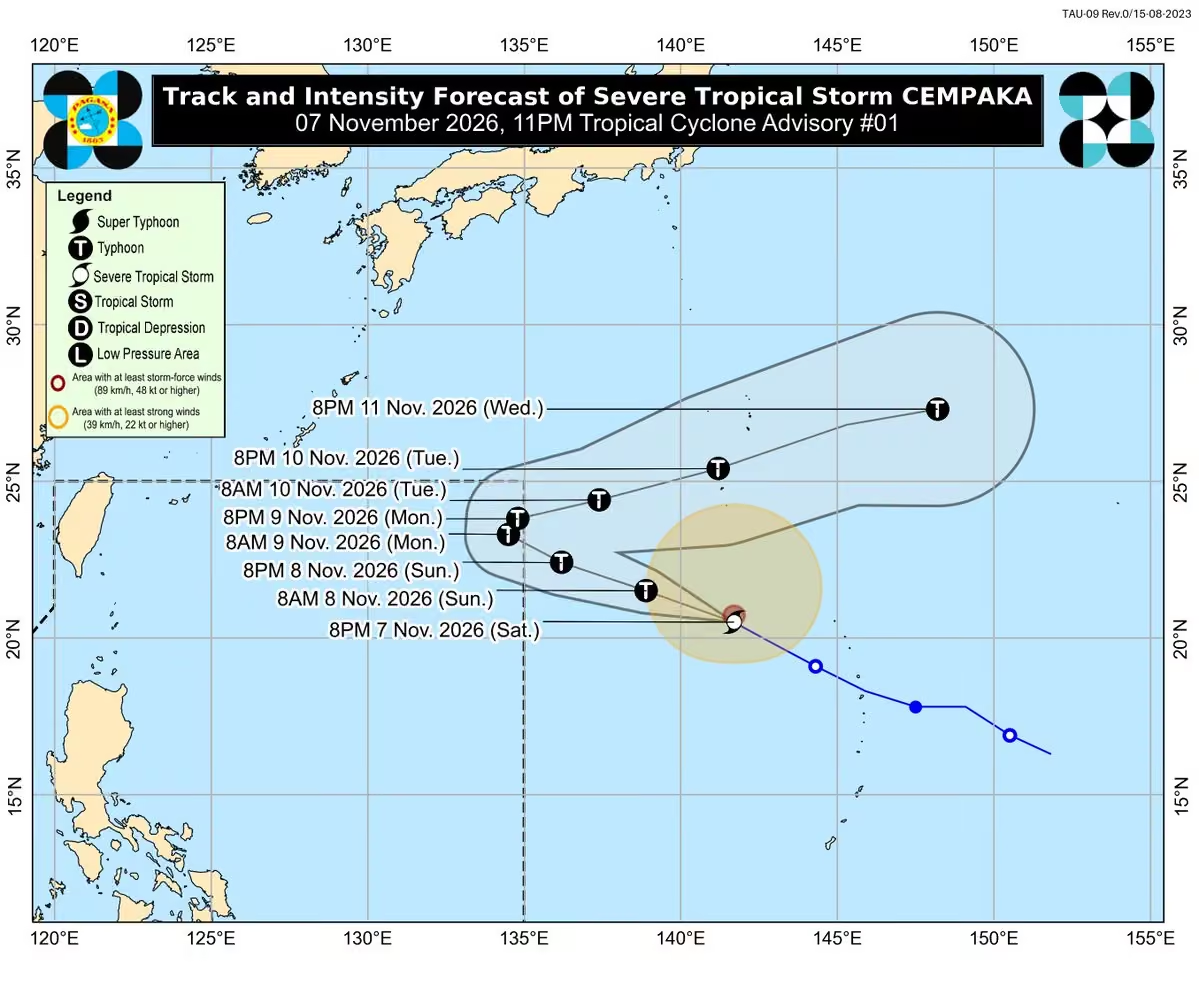
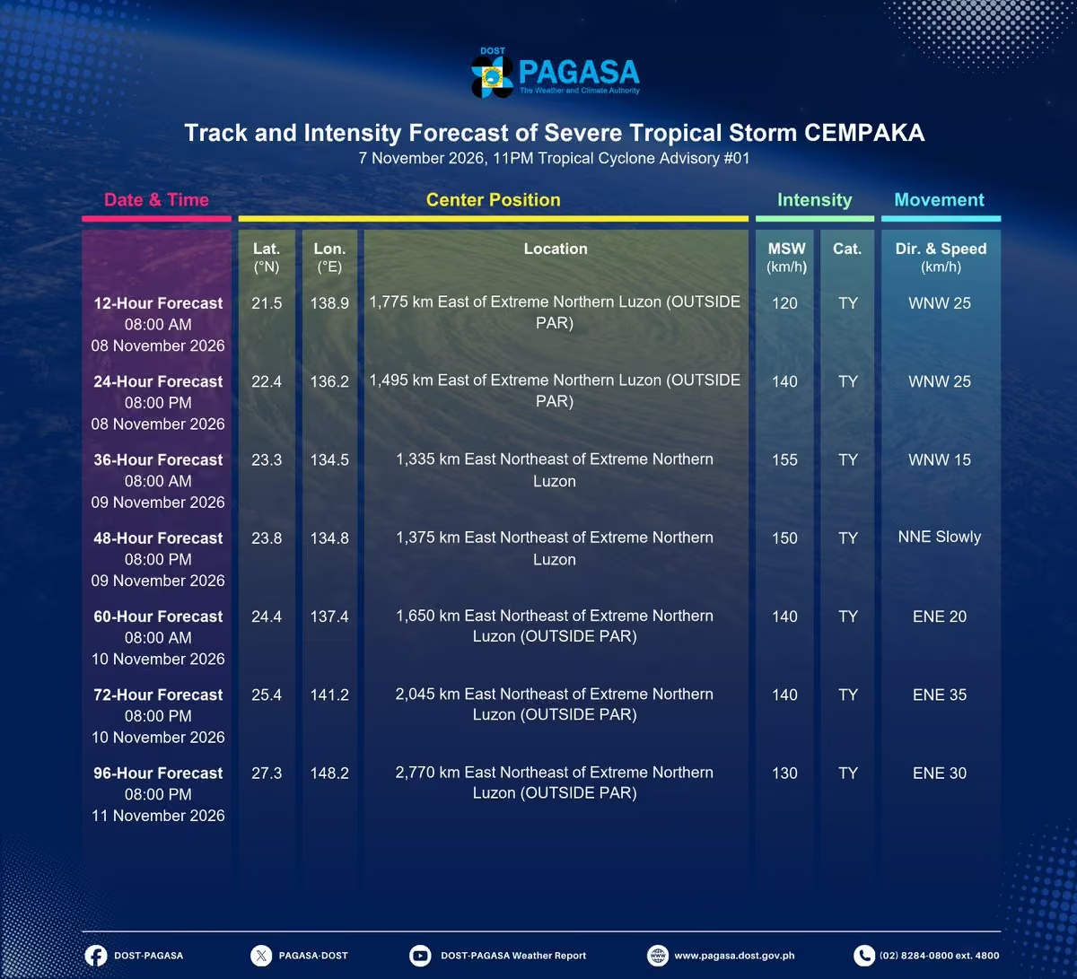
TROPICAL CYCLONE ADVISORY NR. 1
Severe Tropical Storm CEMPAKA
Issued at 11:00 PM, 07 November 2026
Valid for broadcast until the next advisory at 11:00 AM tomorrow.
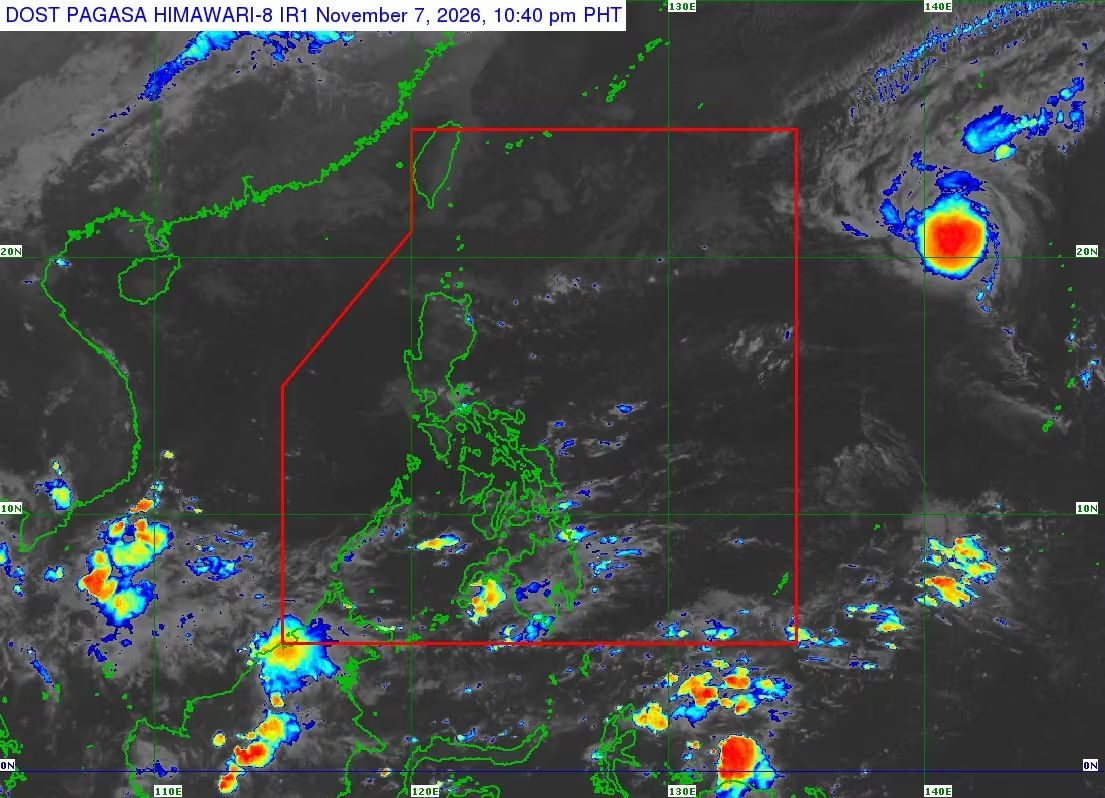
CEMPAKA INTENSIFIES INTO A SEVERE TROPICAL STORM AS IT MOVES WEST NORTHWESTWARD OVER THE SEA NORTHWEST OF NORTHERN MARIANA ISLANDS.
DOST-PAGASA
Link:bagong.pagasa.dost.gov.ph/tropical-cyclone-advisory-iframe -
PAGASA-DOST
@dost_pagasa
Thunderstorm Advisory No. 8 #ncr_prsd
Issued at: 10:50 PM, 07 November 2026(Saturday)
Moderate to heavy rainshowers with lightning and strong winds are expected over Laguna (Liliw, Luisiana, Cavinti, Lumban, Kalayaan, Magdalena, Pagsanjan, Majayjay, Santa Maria, Mabitac, Pangil, Pakil, Siniloan, Famy, Paete, and Santa Cruz), Quezon (Panukulan, Polillo, Real, Sampaloc, Lucban, Sariaya, Candelaria, Quezon, Agdangan, Padre Burgos, Unisan, Gumaca, Plaridel, Guinayangan, Tagkawayan, Lopez, Calauag, Infanta, General Nakar, Dolores, and Pitogo), and Rizal (Pililla, Jala-Jala, and Tanay) within the next 2 hours.
The above condition is affecting Quezon (Pagbilao, Tayabas, Lucena, Atimonan, Mauban, Alabat, Perez, Burdeos, Patnanungan, and Jomalig) which may persist within 2 hours.
All are advised to take precautionary measures against the impacts associated with these hazards which include flash floods and landslides.
Keep monitoring for updates. -
PAGASA-DOST
@dost_pagasa
Thunderstorm Advisory No. 7 #ncr_prsd
Issued at: 9:00 PM, 07 November 2026(Saturday)
Moderate to heavy rainshowers with lightning and strong winds are expected over Bulacan (Norzagaray and San Jose del Monte), Laguna (Pakil, Pangil, Siniloan, Famy, Santa Maria, Paete, Kalayaan, Lumban, Cavinti, Mabitac, Luisiana, and Majayjay), Quezon (Jomalig, Infanta, Real, Mauban, Alabat, Perez, Guinayangan, Calauag, Quezon, Sampaloc, and Lucban), and Rizal (Tanay, Rodriguez, Antipolo, Pililla, Jala-Jala, Baras, and San Mateo) within the next 2 hours.
The above condition is affecting Quezon (General Nakar, Polillo, Burdeos, Panukulan, Patnanungan, and Tagkawayan) which may persist within 2 hours.
All are advised to take precautionary measures against the impacts associated with these hazards which include flash floods and landslides.
Keep monitoring for updates. -
PAGASA-DOST
@dost_pagasa
Thunderstorm Advisory No. 6 #ncr_prsd
Issued at: 6:55 PM, 07 November 2026(Saturday)
Moderate to heavy rainshowers with lightning and strong winds are expected over Laguna (Cavinti, Luisiana, Majayjay, Kalayaan, Lumban, Paete, Pakil, Pangil, Siniloan, Mabitac, Santa Maria, Famy, Pagsanjan, Santa Cruz, and Magdalena), Quezon (Real, Infanta, General Nakar, Burdeos, Panukulan, Polillo, Patnanungan, Tayabas, Lucban, Sampaloc, Sariaya, Lucena, Pagbilao, Atimonan, Calauag, Perez, Quezon, Alabat, and Jomalig), and Rizal (Tanay, Antipolo, Pililla, Jala-Jala, and Baras) within the next 2 hours.
The above condition is affecting Quezon (Mauban) which may persist within 2 hours.
All are advised to take precautionary measures against the impacts associated with these hazards which include flash floods and landslides.
Keep monitoring for updates. -
PAGASA-DOST
@dost_pagasa
5-Day Highest Computed Heat Index and 2-Day Forecast
Issued at: 6:00 PM, 07 November 2026
You may access the information using this link:
www.pagasa.dost.gov.ph/weather/heat-index -
PAGASA-DOST
@dost_pagasa
REGIONAL WEATHER FORECAST for #ncr_prsd
Issued at: 5:00 PM, 7 November 2026
Valid Beginning: 5:00 PM today - 5:00 PM tomorrow
www.pagasa.dost.gov.ph/regional-forecast/ncrprsd
***Help us improve our service by answering this quick survey.
Kindly follow this link: docs.google.com/forms/d/e/1FAIpQLSfqE28lYSNaQt7-z-0wRtwqv… -
PAGASA-DOST
@dost_pagasa
Thunderstorm Advisory No. 5 #ncr_prsd
Issued at: 3:46 PM, 07 November 2026(Saturday)
Moderate to heavy rainshowers with lightning and strong winds are expected over Laguna (Santa Maria, Famy, Pangil, Siniloan, Pakil, Paete, Mabitac, Pagsanjan, Magdalena, Santa Cruz, Luisiana, and Majayjay), Quezon (Polillo, Jomalig, Panukulan, General Nakar, Infanta, Real, Mauban, Tagkawayan, Guinayangan, Lucban, and Tayabas), and Rizal (Tanay) within the next 2 hours.
The above condition is affecting Laguna (Kalayaan, Lumban, and Cavinti) and Quezon (Patnanungan, Burdeos, and Sampaloc) which may persist within 2 hours.
All are advised to take precautionary measures against the impacts associated with these hazards which include flash floods and landslides.
Keep monitoring for updates. -
PAGASA-DOST
@dost_pagasa
Thunderstorm Advisory No. 4 #ncr_prsd
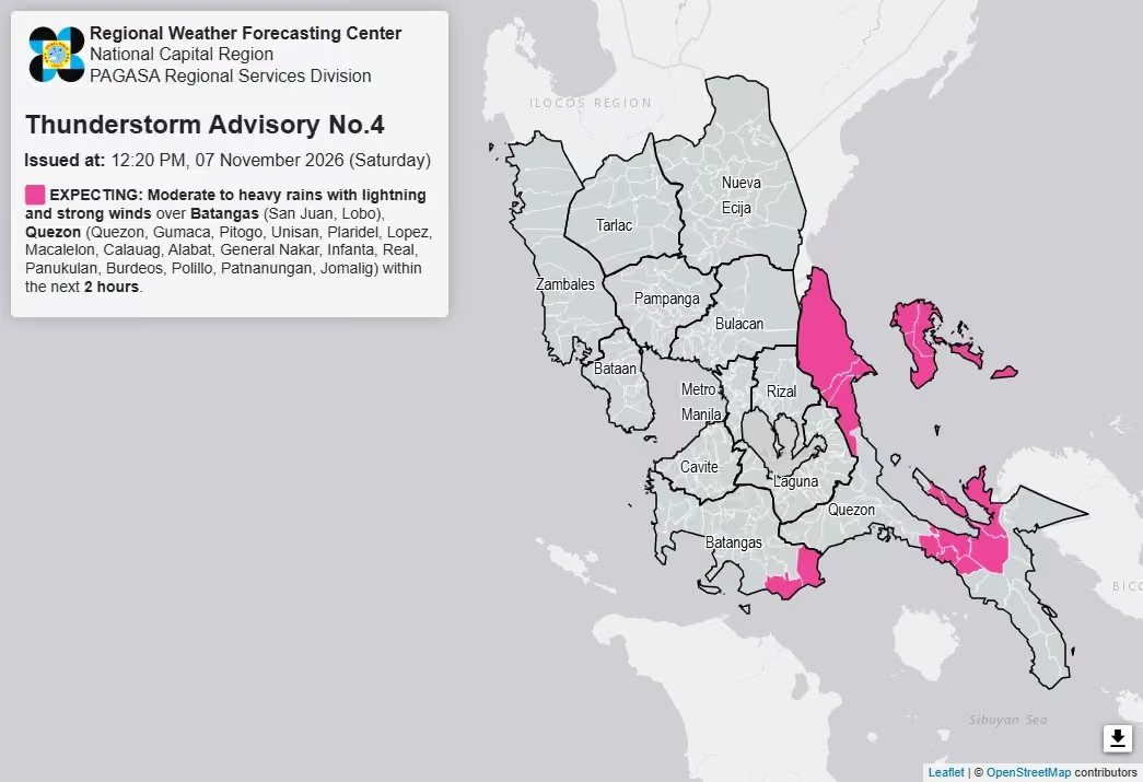
Issued at: 12:20 PM, 07 November 2026(Saturday)
Moderate to heavy rainshowers with lightning and strong winds are expected over Batangas (San Juan and Lobo) and Quezon (Quezon, Gumaca, Pitogo, Unisan, Plaridel, Lopez, Macalelon, Calauag, Alabat, General Nakar, Infanta, Real, Panukulan, Burdeos, Polillo, Patnanungan, and Jomalig) within the next 2 hours.
All are advised to take precautionary measures against the impacts associated with these hazards which include flash floods and landslides.
Keep monitoring for updates. -
PAGASA-DOST
@dost_pagasa
5-DAY REGIONAL WEATHER OUTLOOK for #ncr_prsd
Issued at: 9:00 AM, 7 November 2026
Valid Beginning: 9:00 AM today - 9:00 AM tomorrow
www.pagasa.dost.gov.ph/regional-forecast/ncrprsd
***Help us improve our service by answering this quick survey.
Kindly follow this link: docs.google.com/forms/d/e/1FAIpQLSfqE28lYSNaQt7-z-0wRtwqv… -
PAGASA-DOST
@dost_pagasa
REGIONAL WEATHER FORECAST for GREATER METRO MANILA AREA (GMMA) #ncr_prsd
Issued at: 4:00 AM, 7 November 2026
Valid Beginning: 4:00 AM - 1Thunderstorm Advisory No. 3 #ncr_prsd
Issued at: 8:05 AM, 07 November 2026(Saturday)
Moderate to heavy rainshowers with lightning and strong winds are expected over Bulacan (Dona Remedios Trinidad, San Miguel, San Ildefonso, and San Rafael), Laguna (Santa Maria, Siniloan, and Famy), Nueva Ecija (General Tinio), Quezon (General Nakar, Infanta, Panukulan, Burdeos, Candelaria, Sariaya, Tayabas, Lucban, Lucena, Pagbilao, Sampaloc, Calauag, Jomalig, Patnanungan, Polillo, Tagkawayan, Guinayangan, Real, Quezon, Alabat, Perez, Lopez, Atimonan, Plaridel, and Padre Burgos), and Rizal (Tanay) within the next 3 hours.
The above condition is affecting Quezon (Mauban) which may persist within 2 hours.
All are advised to take precautionary measures against the impacts associated with these hazards which include flash floods and landslides.
Keep monitoring for updates.0:00 AM today
www.pagasa.dost.gov.ph/regional-forecast/ncrprsd -
PAGASA-DOST
@dost_pagasa
REGIONAL WEATHER FORECAST for #ncr_prsd
Issued at: 5:00 AM, 7 November 2026
Valid Beginning: 5:00 AM today - 5:00 AM tomorrow
www.pagasa.dost.gov.ph/regional-forecast/ncrprsd
***Help us improve our service by answering this quick survey.
Kindly follow this link: docs.google.com/forms/d/e/1FAIpQLSfqE28lYSNaQt7-z-0wRtwqv… -
PAGASA-DOST
@dost_pagasa
Thunderstorm Advisory No. 1 #ncr_prsd
Issued at: 2:07 AM, 07 November 2026(Saturday)
Moderate to heavy rainshowers with lightning and strong winds are expected over Batangas (San Juan, Rosario, Lobo, and Taysan), Laguna (Paete, Pakil, Pangil, Siniloan, Famy, Cavinti, Lumban, and Kalayaan), and Quezon (Panukulan, Burdeos, Polillo, Real, Mauban, Atimonan, Sampaloc, Infanta, Perez, Alabat, Tagkawayan, Patnanungan, Jomalig, Calauag, Quezon, and Guinayangan) within the next 2 hours.
All are advised to take precautionary measures against the impacts associated with these hazards which include flash floods and landslides.
Keep monitoring for updates. -
PAGASA-DOST
@dost_pagasa
5-Day Highest Computed Heat Index and 2-Day Forecast
Issued at: 6:00 PM, 06 November 2026
You may access the information using this link:
www.pagasa.dost.gov.ph/weather/heat-index -
PAGASA-DOST
@dost_pagasa
REGIONAL WEATHER FORECAST for #ncr_prsd
Issued at: 5:00 PM, 6 November 2026
Valid Beginning: 5:00 PM today - 5:00 PM tomorrow
www.pagasa.dost.gov.ph/regional-forecast/ncrprsd
***Help us improve our service by answering this quick survey.
Kindly follow this link: docs.google.com/forms/d/e/1FAIpQLSfqE28lYSNaQt7-z-0wRtwqv… -
PAGASA-DOST
@dost_pagasa
Thunderstorm Information #ncr_prsd
Issued at: 10:00 AM, 06 November 2026
Thunderstorm is LESS LIKELY to develop over Greater Metro Manila Area(Metro Manila, Bulacan, Rizal, Laguna and Cavite) within 12 hours.
All are advised to continue monitoring for updates. -
PAGASA-DOST
@dost_pagasa
5-DAY REGIONAL WEATHER OUTLOOK for #ncr_prsd
Issued at: 9:00 AM, 6 November 2026
Valid Beginning: 9:00 AM today - 9:00 AM tomorrow
www.pagasa.dost.gov.ph/regional-forecast/ncrprsd
***Help us improve our service by answering this quick survey.
Kindly follow this link: docs.google.com/forms/d/e/1FAIpQLSfqE28lYSNaQt7-z-0wRtwqv… -
PAGASA-DOST
@dost_pagasa
REGIONAL WEATHER FORECAST for #ncr_prsd
Issued at: 5:00 AM, 6 November 2026
Valid Beginning: 5:00 AM today - 5:00 AM tomorrow
www.pagasa.dost.gov.ph/regional-forecast/ncrprsd
***Help us improve our service by answering this quick survey.
Kindly follow this link: docs.google.com/forms/d/e/1FAIpQLSfqE28lYSNaQt7-z-0wRtwqv… -
PAGASA-DOST
@dost_pagasa
REGIONAL WEATHER FORECAST for GREATER METRO MANILA AREA (GMMA) #ncr_prsd
Issued at: 4:00 AM, 6 November 2026
Valid Beginning: 4:00 AM - 10:00 AM today
www.pagasa.dost.gov.ph/regional-forecast/ncrprsd -
PAGASA-DOST
@dost_pagasa
Thunderstorm Information #ncr_prsd
Issued at: 10:00 PM, 05 November 2026
Thunderstorm is LESS LIKELY to develop over Greater Metro Manila Area(Metro Manila, Bulacan, Rizal, Laguna and Cavite) within 12 hours.
All are advised to continue monitoring for updates. -
PAGASA-DOST
@dost_pagasa
5-Day Highest Computed Heat Index and 2-Day Forecast
Issued at: 6:00 PM, 05 November 2026
You may access the information using this link:
www.pagasa.dost.gov.ph/weather/heat-index -
PAGASA-DOST
@dost_pagasa
REGIONAL WEATHER FORECAST for #ncr_prsd
Issued at: 5:00 PM, 5 November 2026
Valid Beginning: 5:00 PM today - 5:00 PM tomorrow
www.pagasa.dost.gov.ph/regional-forecast/ncrprsd
***Help us improve our service by answering this quick survey.
Kindly follow this link: docs.google.com/forms/d/e/1FAIpQLSfqE28lYSNaQt7-z-0wRtwqv… -
PAGASA-DOST
@dost_pagasa
Thunderstorm Information #ncr_prsd
Issued at: 10:00 AM, 05 November 2026
Thunderstorm is LESS LIKELY to develop over Greater Metro Manila Area(Metro Manila, Bulacan, Rizal, Laguna and Cavite) within 12 hours.
All are advised to continue monitoring for updates. -
PAGASA-DOST
@dost_pagasa
5-DAY REGIONAL WEATHER OUTLOOK for #ncr_prsd
Issued at: 9:00 AM, 5 November 2026
Valid Beginning: 9:00 AM today - 9:00 AM tomorrow
www.pagasa.dost.gov.ph/regional-forecast/ncrprsd
***Help us improve our service by answering this quick survey.
Kindly follow this link: docs.google.com/forms/d/e/1FAIpQLSfqE28lYSNaQt7-z-0wRtwqv… -
PAGASA-DOST
@dost_pagasa
REGIONAL WEATHER FORECAST for #ncr_prsd
Issued at: 5:00 AM, 5 November 2026
Valid Beginning: 5:00 AM today - 5:00 AM tomorrow
www.pagasa.dost.gov.ph/regional-forecast/ncrprsd
***Help us improve our service by answering this quick survey.
Kindly follow this link: docs.google.com/forms/d/e/1FAIpQLSfqE28lYSNaQt7-z-0wRtwqv… -
PAGASA-DOST
@dost_pagasa
REGIONAL WEATHER FORECAST for GREATER METRO MANILA AREA (GMMA) #ncr_prsd
Issued at: 4:00 AM, 5 November 2026
Valid Beginning: 4:00 AM - 10:00 AM today
www.pagasa.dost.gov.ph/regional-forecast/ncrprsd -
PAGASA-DOST
@dost_pagasa
5-Day Highest Computed Heat Index and 2-Day Forecast
Issued at: 6:00 PM, 04 November 2026
You may access the information using this link:
www.pagasa.dost.gov.ph/weather/heat-index -
PAGASA-DOST
@dost_pagasa
REGIONAL WEATHER FORECAST for #ncr_prsd
Issued at: 5:00 PM, 4 November 2026
Valid Beginning: 5:00 PM today - 5:00 PM tomorrow
www.pagasa.dost.gov.ph/regional-forecast/ncrprsd
***Help us improve our service by answering this quick survey.
Kindly follow this link: docs.google.com/forms/d/e/1FAIpQLSfqE28lYSNaQt7-z-0wRtwqv… -
PAGASA-DOST
@dost_pagasa
Thunderstorm Watch #ncr_prsd
Issued at: 10:00 AM, 04 November 2026
Thunderstorm is MORE LIKELY to develop over Greater Metro Manila Area(Metro Manila, Bulacan, Rizal, Laguna and Cavite) within 12 hours.
All are advised to continue monitoring for updates. -
PAGASA-DOST
@dost_pagasa
5-DAY REGIONAL WEATHER OUTLOOK for #ncr_prsd
Issued at: 9:00 AM, 4 November 2026
Valid Beginning: 9:00 AM today - 9:00 AM tomorrow
www.pagasa.dost.gov.ph/regional-forecast/ncrprsd
***Help us improve our service by answering this quick survey.
Kindly follow this link: docs.google.com/forms/d/e/1FAIpQLSfqE28lYSNaQt7-z-0wRtwqv… -
PAGASA-DOST
@dost_pagasa
REGIONAL WEATHER FORECAST for #ncr_prsd
Issued at: 5:00 AM, 4 November 2026
Valid Beginning: 5:00 AM today - 5:00 AM tomorrow
www.pagasa.dost.gov.ph/regional-forecast/ncrprsd
***Help us improve our service by answering this quick survey.
Kindly follow this link: docs.google.com/forms/d/e/1FAIpQLSfqE28lYSNaQt7-z-0wRtwqv… -
PAGASA-DOST
@dost_pagasa
REGIONAL WEATHER FORECAST for GREATER METRO MANILA AREA (GMMA) #ncr_prsd
Issued at: 4:00 AM, 4 November 2026
Valid Beginning: 4:00 AM - 10:00 AM today
www.pagasa.dost.gov.ph/regional-forecast/ncrprsd -
PAGASA-DOST
@dost_pagasa
Thunderstorm Advisory No. 7 #ncr_prsd
Issued at: 3:05 AM, 04 November 2026(Wednesday)
Moderate to heavy rainshowers with lightning and strong winds are expected over Quezon (Perez, Alabat, Quezon, Atimonan, Plaridel, Padre Burgos, Lucena, Tayabas, Candelaria, Sariaya, Lucban, Pagbilao, Mauban, Polillo, Jomalig, Patnanungan, Burdeos, Panukulan, Calauag, Gumaca, Sampaloc, Real, Dolores, Agdangan, and Unisan) within the next 2 hours.
All are advised to take precautionary measures against the impacts associated with these hazards which include flash floods and landslides.
Keep monitoring for updates. -
PAGASA-DOST
@dost_pagasa
Thunderstorm Advisory No. 6 #ncr_prsd
Issued at: 9:25 PM, 03 November 2026(Tuesday)
Moderate to heavy rainshowers with lightning and strong winds are expected over Quezon (Tagkawayan, Calauag, Polillo, Burdeos, Panukulan, Patnanungan, Guinayangan, Quezon, Mauban, Real, Infanta, General Nakar, Perez, and Alabat) and Zambales (Masinloc, Iba, Palauig, and Botolan) within the next 3 hours.
Heavy to intense rainshowers with lightning and strong winds are affecting Zambales (Santa Cruz and Candelaria) which may persist within 2 hours.
All are advised to take precautionary measures against the impacts associated with these hazards which include flash floods and landslides.
Keep monitoring for updates. -
PAGASA-DOST
@dost_pagasa
Thunderstorm Advisory No. 5 #ncr_prsd
Issued at: 8:17 PM, 03 November 2026(Tuesday)
Moderate to heavy rainshowers with lightning and strong winds are expected over Quezon (Jomalig, Patnanungan, Burdeos, Polillo, Panukulan, Perez, Alabat, Calauag, and Quezon) and Zambales (Candelaria) within the next 2 hours.
The above condition is affecting Zambales (Santa Cruz) which may persist within 2 hours and may affect nearby areas.
All are advised to take precautionary measures against the impacts associated with these hazards which include flash floods and landslides.
Keep monitoring for updates. -
PAGASA-DOST
@dost_pagasa
Thunderstorm Advisory No. 4 #ncr_prsd
Issued at: 6:19 PM, 03 November 2026(Tuesday)
Moderate to heavy rainshowers with lightning and strong winds are expected over Quezon (Jomalig, Patnanungan, Burdeos, Panukulan, and Polillo), Tarlac (San Clemente), and Zambales (Santa Cruz and Candelaria) within the next 2 hours.
All are advised to take precautionary measures against the impacts associated with these hazards which include flash floods and landslides.
Keep monitoring for updates. -
PAGASA-DOST
@dost_pagasa
5-Day Highest Computed Heat Index and 2-Day Forecast
Issued at: 6:00 PM, 03 November 2026
You may access the information using this link:
www.pagasa.dost.gov.ph/weather/heat-index -
PAGASA-DOST
@dost_pagasa
REGIONAL WEATHER FORECAST for #ncr_prsd
Issued at: 5:00 PM, 3 November 2026
Valid Beginning: 5:00 PM today - 5:00 PM tomorrow
www.pagasa.dost.gov.ph/regional-forecast/ncrprsd
***Help us improve our service by answering this quick survey.
Kindly follow this link: docs.google.com/forms/d/e/1FAIpQLSfqE28lYSNaQt7-z-0wRtwqv… -
PAGASA-DOST
@dost_pagasa
5-DAY REGIONAL WEATHER OUTLOOK for #ncr_prsd
Issued at: 9:00 AM, 3 November 2026
Valid Beginning: 9:00 AM today - 9:00 AM tomorrow
www.pagasa.dost.gov.ph/regional-forecast/ncrprsd
***Help us improve our service by answering this quick survey.
Kindly follow this link: docs.google.com/forms/d/e/1FAIpQLSfqE28lYSNaQt7-z-0wRtwqv… -
PAGASA-DOST
@dost_pagasa
Thunderstorm Advisory No. 3 #ncr_prsd
Issued at: 8:40 AM, 03 November 2026(Tuesday)
Moderate to heavy rainshowers with lightning and strong winds are expected over Bataan (Dinalupihan, Hermosa, Orani, Samal, Abucay, Balanga, Orion, Pilar, Limay, and Mariveles), Bulacan (Hagonoy and Paombong), Cavite (Noveleta, Cavite City, Tanza, and Rosario), and Pampanga (Floridablanca, Lubao, Sasmuan, Macabebe, and Masantol) within the next 2 hours.
All are advised to take precautionary measures against the impacts associated with these hazards which include flash floods and landslides.
Keep monitoring for updates. -
PAGASA-DOST
@dost_pagasa
Thunderstorm Advisory No. 2 #ncr_prsd
Issued at: 5:52 AM, 03 November 2026(Tuesday)
Moderate to heavy rainshowers with lightning and strong winds are expected over Bulacan (Norzagaray and Dona Remedios Trinidad), Nueva Ecija (Carranglan, General Tinio, and Pantabangan), Quezon (Infanta, Real, Panukulan, Burdeos, and Polillo), and Rizal (Rodriguez, Tanay, and Antipolo) within the next 2 hours.
The above condition is affecting Quezon (General Nakar) which may persist within 2 hours.
All are advised to take precautionary measures against the impacts associated with these hazards which include flash floods and landslides.
Keep monitoring for updates. -
PAGASA-DOST
@dost_pagasa
REGIONAL WEATHER FORECAST for #ncr_prsd
Issued at: 5:00 AM, 3 November 2026
Valid Beginning: 5:00 AM today - 5:00 AM tomorrow
www.pagasa.dost.gov.ph/regional-forecast/ncrprsd
***Help us improve our service by answering this quick survey.
Kindly follow this link: docs.google.com/forms/d/e/1FAIpQLSfqE28lYSNaQt7-z-0wRtwqv… -
PAGASA-DOST
@dost_pagasa
Thunderstorm Advisory No. 1 #ncr_prsd
Issued at: 3:55 AM, 03 November 2026(Tuesday)
Moderate to heavy rainshowers with lightning and strong winds are expected over Bulacan (Dona Remedios Trinidad and Norzagaray), Nueva Ecija (Carranglan, Pantabangan, Rizal, Laur, and General Tinio), Quezon (General Nakar), and Rizal (Rodriguez) within the next 2 hours.
The above condition is affecting Nueva Ecija (Gabaldon and Bongabon) which may persist within 2 hours and may affect nearby areas.
All are advised to take precautionary measures against the impacts associated with these hazards which include flash floods and landslides.
Keep monitoring for updates. -
PAGASA-DOST
@dost_pagasa
REGIONAL WEATHER FORECAST for GREATER METRO MANILA AREA (GMMA) #ncr_prsd
Issued at: 4:00 AM, 3 November 2026
Valid Beginning: 4:00 AM - 10:00 AM today
www.pagasa.dost.gov.ph/regional-forecast/ncrprsd -
PAGASA-DOST
@dost_pagasa
5-Day Highest Computed Heat Index and 2-Day Forecast
Issued at: 6:00 PM, 02 November 2026
You may access the information using this link:
www.pagasa.dost.gov.ph/weather/heat-index -
PAGASA-DOST
@dost_pagasa
REGIONAL WEATHER FORECAST for #ncr_prsd
Issued at: 5:00 PM, 2 November 2026
Valid Beginning: 5:00 PM today - 5:00 PM tomorrow
www.pagasa.dost.gov.ph/regional-forecast/ncrprsd
***Help us improve our service by answering this quick survey.
Kindly follow this link: docs.google.com/forms/d/e/1FAIpQLSfqE28lYSNaQt7-z-0wRtwqv… -
PAGASA-DOST
@dost_pagasa
Thunderstorm Watch #ncr_prsd
Issued at: 10:00 AM, 02 November 2026
Thunderstorm is MORE LIKELY to develop over Greater Metro Manila Area(Metro Manila, Bulacan, Rizal, Laguna and Cavite) within 12 hours.
All are advised to continue monitoring for updates. -
PAGASA-DOST
@dost_pagasa
5-DAY REGIONAL WEATHER OUTLOOK for #ncr_prsd
Issued at: 9:00 AM, 2 November 2026
Valid Beginning: 9:00 AM today - 9:00 AM tomorrow
www.pagasa.dost.gov.ph/regional-forecast/ncrprsd
***Help us improve our service by answering this quick survey.
Kindly follow this link: docs.google.com/forms/d/e/1FAIpQLSfqE28lYSNaQt7-z-0wRtwqv… -
PAGASA-DOST
@dost_pagasa
REGIONAL WEATHER FORECAST for #ncr_prsd
Issued at: 5:00 AM, 2 November 2026
Valid Beginning: 5:00 AM today - 5:00 AM tomorrow
www.pagasa.dost.gov.ph/regional-forecast/ncrprsd
***Help us improve our service by answering this quick survey.
Kindly follow this link: docs.google.com/forms/d/e/1FAIpQLSfqE28lYSNaQt7-z-0wRtwqv… -
PAGASA-DOST
@dost_pagasa
REGIONAL WEATHER FORECAST for GREATER METRO MANILA AREA (GMMA) #ncr_prsd
Issued at: 4:00 AM, 2 November 2026
Valid Beginning: 4:00 AM - 10:00 AM today
www.pagasa.dost.gov.ph/regional-forecast/ncrprsd -
PAGASA-DOST
@dost_pagasa
Thunderstorm Advisory No. 11 #ncr_prsd
Issued at: 3:30 AM, 02 November 2026(Monday)
Moderate to heavy rainshowers with lightning and strong winds are expected over Bulacan (Dona Remedios Trinidad, San Miguel, and San Ildefonso), Laguna (Siniloan, Santa Maria, Famy, Mabitac, and Pangil), Nueva Ecija (Pantabangan, Rizal, Laur, Gabaldon, Bongabon, Palayan, General Tinio, Gapan, Penaranda, and San Leonardo), Quezon (General Nakar, Real, Infanta, Burdeos, Panukulan, Polillo, and Patnanungan), and Rizal (Tanay and Pililla) within the next 2 hours.
All are advised to take precautionary measures against the impacts associated with these hazards which include flash floods and landslides.
Keep monitoring for updates. -
PAGASA-DOST
@dost_pagasa
Thunderstorm Advisory No. 10 #ncr_prsd
Issued at: 11:26 PM, 01 November 2026(Sunday)
Moderate to heavy rainshowers with lightning and strong winds are expected over Bulacan (Dona Remedios Trinidad), Laguna (Santa Maria, Siniloan, and Famy), Nueva Ecija (General Tinio), Quezon (Polillo, Burdeos, Panukulan, Real, Mauban, Patnanungan, and General Nakar), Rizal (Tanay), and Zambales (Palauig, Iba, and Botolan) within the next 2 hours.
The above condition is affecting Quezon (Infanta) which may persist within 2 hours.
All are advised to take precautionary measures against the impacts associated with these hazards which include flash floods and landslides.
Keep monitoring for updates. -
PAGASA-DOST
@dost_pagasa
Thunderstorm Advisory No. 9 #ncr_prsd
Issued at: 9:20 PM, 01 November 2026(Sunday)
Moderate to heavy rainshowers with lightning and strong winds are expected over Bulacan (Dona Remedios Trinidad and Norzagaray), Laguna (Cavinti, Lumban, Kalayaan, Pakil, Paete, Pangil, Mabitac, Famy, Santa Maria, and Siniloan), Quezon (General Nakar, Real, Mauban, Sampaloc, Perez, Alabat, Polillo, and Tagkawayan), Rizal (Pililla, Jala-Jala, and Tanay), and Zambales (San Marcelino, Castillejos, and Cabangan) within the next 2 hours.
The above condition is affecting Zambales (San Antonio, San Felipe, and San Narciso) which may persist within 2 hours.
All are advised to take precautionary measures against the impacts associated with these hazards which include flash floods and landslides.
Keep monitoring for updates. -
PAGASA-DOST
@dost_pagasa
Thunderstorm Advisory No. 8 #ncr_prsd
Issued at: 7:07 PM, 01 November 2026(Sunday)
Moderate to heavy rainshowers with lightning and strong winds are expected over Laguna (Pangil, Siniloan, Famy, Santa Maria, Paete, Pakil, Mabitac, Kalayaan, Lumban, Cavinti, and Luisiana) and Quezon (Guinayangan, Calauag, Quezon, Alabat, Perez, Atimonan, Gumaca, Plaridel, Lopez, Real, Sampaloc, Lucban, Tayabas, and Pagbilao) within the next 2 hours.
The above condition is affecting Quezon (Mauban) which may persist within 2 hours.
All are advised to take precautionary measures against the impacts associated with these hazards which include flash floods and landslides.
Keep monitoring for updates. -
PAGASA-DOST
@dost_pagasa
5-Day Highest Computed Heat Index and 2-Day Forecast
Issued at: 6:00 PM, 01 November 2026
You may access the information using this link:
www.pagasa.dost.gov.ph/weather/heat-index -
PAGASA-DOST
@dost_pagasa
REGIONAL WEATHER FORECAST for #ncr_prsd
Issued at: 5:00 PM, 1 November 2026
Valid Beginning: 5:00 PM today - 5:00 PM tomorrow
www.pagasa.dost.gov.ph/regional-forecast/ncrprsd
***Help us improve our service by answering this quick survey.
Kindly follow this link: docs.google.com/forms/d/e/1FAIpQLSfqE28lYSNaQt7-z-0wRtwqv… -
PAGASA-DOST
@dost_pagasa
Thunderstorm Advisory No. 7 #ncr_prsd
Issued at: 4:40 PM, 01 November 2026(Sunday)
Moderate to heavy rainshowers with lightning and strong winds are expected over Bataan (Mariveles, Bagac, Limay, Orion, and Pilar), Bulacan (Dona Remedios Trinidad, San Miguel, San Ildefonso, and San Rafael), Nueva Ecija (Cabiao, Gapan, General Tinio, San Antonio, San Isidro, Aliaga, Cabanatuan, Cuyapo, Gabaldon, General Mamerto Natividad, Guimba, Jaen, Laur, Licab, Nampicuan, Palayan, Penaranda, Quezon, San Leonardo, Santa Rosa, Santo Domingo, Talavera, Talugtug, Zaragoza, Munoz, and Lupao), Pampanga (Candaba, Arayat, Magalang, Mabalacat, Angeles, Mexico, Porac, and Santa Ana), Quezon (Tagkawayan, Guinayangan, and General Nakar), Zambales (Santa Cruz, Candelaria, Masinloc, Palauig, Iba, and Botolan), and Tarlac within the next 2 hours.
All are advised to take precautionary measures against the impacts associated with these hazards which include flash floods and landslides.
Keep monitoring for updates. -
PAGASA-DOST
@dost_pagasa
Thunderstorm Advisory No. 6 #ncr_prsd
Issued at: 2:45 PM, 01 November 2026(Sunday)
Moderate to heavy rainshowers with lightning and strong winds are expected over Bataan (Dinalupihan and Hermosa), Batangas (Malvar, Mataasnakahoy, Lipa, Balete, Nasugbu, Lian, Tuy, Calaca, Balayan, Calatagan, Lemery, Agoncillo, San Nicolas, and Taal), Cavite (Maragondon, Ternate, General Trias, Trece Martires, Bacoor, Carmona, Cavite City, Dasmarinas, Gen. Mariano Alvarez, Imus, Kawit, Naic, Noveleta, Rosario, and Tanza), Laguna (Bay, Calauan, Alaminos, San Pablo, Victoria, Nagcarlan, Pila, Santa Cruz, Liliw, San Pedro, Rizal, Santa Maria, Mabitac, Pakil, Famy, Siniloan, Pangil, and Binan), Nueva Ecija (Cabiao, Gapan, General Tinio, San Antonio, San Isidro, Aliaga, Bongabon, Cabanatuan, Cuyapo, Gabaldon, General Mamerto Natividad, Guimba, Jaen, Laur, Licab, Llanera, Nampicuan, Palayan, Penaranda, Quezon, Rizal, San Leonardo, Santa Rosa, Santo Domingo, Munoz, Talavera, Talugtug, and Zaragoza), Quezon (Tagkawayan, Infanta, Mauban, Pagbilao, Real, Sampaloc, Agdangan, Alabat, Atimonan, Burdeos, Calauag, Catanauan, General Luna, Gumaca, Jomalig, Lopez, Macalelon, Mulanay, Padre Burgos, Panukulan, Patnanungan, Perez, Pitogo, Plaridel, Polillo, Quezon, Unisan, Guinayangan, San Narciso, and Buenavista), Zambales (Candelaria, Santa Cruz, Masinloc, San Marcelino, Botolan, Cabangan, Iba, Palauig, Subic, Castillejos, San Felipe, San Narciso, and San Antonio), Bulacan, Metro Manila, Pampanga, Rizal, and Tarlac within the next 2 hours.
The above condition is affecting Batangas (Laurel, Talisay, Tanauan, and Santo Tomas), Cavite (Alfonso, Tagaytay, Silang, Amadeo, Indang, Mendez, General Emilio Aguinaldo, and Magallanes), Laguna (Calamba, Santa Rosa, Cabuyao, and Los Banos), and Quezon (General Nakar) which may persist within 2 hours.
All are advised to take precautionary measures against the impacts associated with these hazards which include flash floods and landslides.
Keep monitoring for updates. -
PAGASA-DOST
@dost_pagasa
Thunderstorm Advisory No. 5 #ncr_prsd
Issued at: 1:50 PM, 01 November 2026(Sunday)
Moderate to heavy rainshowers with lightning and strong winds are expected over Batangas (Santo Tomas, Tanauan, Lipa, Malvar, Balete, and Mataasnakahoy), Laguna (Calamba, Los Banos, Calauan, Bay, Cabuyao, Nagcarlan, Rizal, Victoria, Liliw, and Pila), Metro Manila (Marikina, Quezon City, Caloocan, Valenzuela, Malabon, and Navotas), Nueva Ecija (Cabiao, Gapan, General Tinio, San Antonio, San Isidro, Aliaga, Bongabon, Cabanatuan, Cuyapo, Gabaldon, General Mamerto Natividad, Guimba, Jaen, Laur, Licab, Llanera, Nampicuan, Palayan, Penaranda, Quezon, Rizal, San Leonardo, Santa Rosa, Santo Domingo, Munoz, Talavera, Talugtug, and Zaragoza), Quezon (Infanta, Panukulan, Polillo, Real, Perez, Alabat, Quezon, Atimonan, Plaridel, Unisan, Gumaca, Agdangan, Padre Burgos, Pitogo, Tagkawayan, Guinayangan, Calauag, Mauban, and Sampaloc), Rizal (Antipolo, Rodriguez, San Mateo, Tanay, Angono, Baras, Binangonan, Cainta, Cardona, Morong, Taytay, and Teresa), Zambales (Santa Cruz, Candelaria, Masinloc, Palauig, Iba, and Botolan), Bulacan, Pampanga, and Tarlac within the next 2 hours.
The above condition is affecting Laguna (San Pablo and Alaminos) and Quezon (General Nakar, Tiaong, Dolores, and San Antonio) which may persist within 2 hours.
All are advised to take precautionary measures against the impacts associated with these hazards which include flash floods and landslides.
Keep monitoring for updates. -
PAGASA-DOST
@dost_pagasa
Thunderstorm Advisory No. 4 #ncr_prsd
Issued at: 12:35 PM, 01 November 2026(Sunday)
Moderate to heavy rainshowers with lightning and strong winds are expected over Bulacan (San Ildefonso, San Rafael, Baliuag, Norzagaray, Angat, Bustos, San Jose del Monte, Pandi, Plaridel, Pulilan, Santa Maria, Bocaue, Marilao, Balagtas, Guiguinto, Obando, Bulakan, Malolos, Calumpit, Paombong, Hagonoy, and Meycauayan), Laguna (Santa Maria, Siniloan, Famy, Mabitac, Pakil, and Pangil), Metro Manila (Marikina, Valenzuela, Malabon, Navotas, Caloocan, and Quezon City), Nueva Ecija (Cabanatuan, Gabaldon, Laur, Santa Rosa, Penaranda, Palayan, San Leonardo, Jaen, Zaragoza, San Antonio, San Isidro, Cabiao, Guimba, Licab, Quezon, Aliaga, Bongabon, General Mamerto Natividad, Talavera, Llanera, Rizal, Santo Domingo, and Nampicuan), Pampanga (Candaba, Arayat, Magalang, Mabalacat, Angeles, Santa Ana, Mexico, San Luis, San Simon, Apalit, San Fernando, Santo Tomas, Bacolor, Guagua, Porac, Santa Rita, Minalin, Masantol, and Macabebe), Quezon (Guinayangan, Calauag, General Nakar, Polillo, Panukulan, Quezon, Perez, Alabat, Infanta, and Real), Rizal (Rodriguez, Tanay, Antipolo, Baras, San Mateo, Teresa, Morong, and Pililla), Tarlac (Mayantoc, Santa Ignacia, Tarlac City, La Paz, Concepcion, Capas, San Jose, Bamban, San Clemente, Camiling, Victoria, Pura, Gerona, Moncada, Ramos, Paniqui, and Anao), and Zambales (Botolan, Iba, Palauig, Masinloc, and Candelaria) within the next 2 hours.
The above condition is affecting Bulacan (Dona Remedios Trinidad and San Miguel), Nueva Ecija (Gapan and General Tinio), and Quezon (Tagkawayan) which may persist within 2 hours.
All are advised to take precautionary measures against the impacts associated with these hazards which include flash floods and landslides.
Keep monitoring for updates. -
PAGASA-DOST
@dost_pagasa
Thunderstorm Advisory No. 3 #ncr_prsd
Issued at: 10:45 AM, 01 November 2026(Sunday)
Moderate to heavy rainshowers with lightning and strong winds are expected over Bulacan (Norzagaray, San Miguel, San Ildefonso, San Rafael, Angat, Baliuag, and Bustos), Laguna (Santa Maria), Nueva Ecija (Gapan, Cabanatuan, Santa Rosa, Penaranda, San Leonardo, Jaen, Zaragoza, Licab, Aliaga, San Antonio, Cabiao, and San Isidro), Pampanga (Magalang, Arayat, Candaba, Santa Ana, Mexico, San Luis, Mabalacat, and Angeles), Quezon (Panukulan, Polillo, Jomalig, Patnanungan, and Burdeos), Rizal (Rodriguez, Tanay, Antipolo, and Baras), and Tarlac (La Paz, Tarlac City, Concepcion, Gerona, Victoria, Santa Ignacia, San Jose, Capas, Bamban, and Mayantoc) within the next 2 hours.
The above condition is affecting Bulacan (Dona Remedios Trinidad), Nueva Ecija (General Tinio), and Quezon (General Nakar and Infanta) which may persist within 2 hours.
All are advised to take precautionary measures against the impacts associated with these hazards which include flash floods and landslides.
Keep monitoring for updates. -
PAGASA-DOST
@dost_pagasa
5-DAY REGIONAL WEATHER OUTLOOK for #ncr_prsd
Issued at: 9:00 AM, 1 November 2026
Valid Beginning: 9:00 AM today - 9:00 AM tomorrow
www.pagasa.dost.gov.ph/regional-forecast/ncrprsd
***Help us improve our service by answering this quick survey.
Kindly follow this link: docs.google.com/forms/d/e/1FAIpQLSfqE28lYSNaQt7-z-0wRtwqv… -
PAGASA-DOST
@dost_pagasa
Thunderstorm Advisory No. 2 #ncr_prsd
Issued at: 8:45 AM, 01 November 2026(Sunday)
Moderate to heavy rainshowers with lightning and strong winds are expected over Bulacan (Norzagaray, San Ildefonso, San Rafael, Angat, San Jose del Monte, and San Miguel), Laguna (Santa Maria), Nueva Ecija (General Tinio, Gapan, and Penaranda), Quezon (Panukulan, Polillo, Burdeos, Infanta, Patnanungan, and Jomalig), and Rizal (Rodriguez, Antipolo, Tanay, and Baras) within the next 2 hours.
The above condition is affecting Bulacan (Dona Remedios Trinidad) and Quezon (General Nakar) which may persist within 2 hours.
All are advised to take precautionary measures against the impacts associated with these hazards which include flash floods and landslides.
Keep monitoring for updates. -
PAGASA-DOST
@dost_pagasa
Thunderstorm Advisory No. 1 #ncr_prsd
Issued at: 6:35 AM, 01 November 2026(Sunday)
Moderate to heavy rainshowers with lightning and strong winds are expected over Laguna (Santa Maria, Mabitac, Siniloan, Famy, Pangil, Paete, Pakil, Lumban, and Kalayaan), Quezon (General Nakar, Burdeos, Patnanungan, and Jomalig), and Rizal (Tanay, Pililla, Jala-Jala, Antipolo, and Baras) within the next 2 hours.
The above condition is affecting Quezon (Infanta, Real, Panukulan, and Polillo) which may persist within 2 hours.
All are advised to take precautionary measures against the impacts associated with these hazards which include flash floods and landslides.
Keep monitoring for updates. -
PAGASA-DOST
@dost_pagasa
REGIONAL WEATHER FORECAST for #ncr_prsd
Issued at: 5:00 AM, 1 November 2026
Valid Beginning: 5:00 AM today - 5:00 AM tomorrow
www.pagasa.dost.gov.ph/regional-forecast/ncrprsd
***Help us improve our service by answering this quick survey.
Kindly follow this link: docs.google.com/forms/d/e/1FAIpQLSfqE28lYSNaQt7-z-0wRtwqv… -
PAGASA-DOST
@dost_pagasa
REGIONAL WEATHER FORECAST for GREATER METRO MANILA AREA (GMMA) #ncr_prsd
Issued at: 4:00 AM, 1 November 2026
Valid Beginning: 4:00 AM - 10:00 AM today
www.pagasa.dost.gov.ph/regional-forecast/ncrprsd -
PAGASA-DOST
@dost_pagasa
Thunderstorm Advisory No. 5 #ncr_prsd
Issued at: 11:05 PM, 31 October 2026(Saturday)
Moderate to heavy rainshowers with lightning and strong winds are expected over Laguna (San Pablo, Alaminos, Bay, Calauan, Cavinti, Majayjay, Luisiana, Liliw, Nagcarlan, Rizal, Magdalena, Pagsanjan, Santa Maria, Famy, Siniloan, Pangil, Pakil, Mabitac, Lumban, Kalayaan, Paete, Victoria, Santa Cruz, and Pila), Quezon (Sampaloc, Lucban, Real, Infanta, and Mauban), and Rizal (Pililla and Jala-Jala) within the next 2 hours.
All are advised to take precautionary measures against the impacts associated with these hazards which include flash floods and landslides.
Keep monitoring for updates. -
PAGASA-DOST
@dost_pagasa
Thunderstorm Advisory No. 4 #ncr_prsd
Issued at: 9:19 PM, 31 October 2026(Saturday)
Moderate to heavy rainshowers with lightning and strong winds are expected over Bataan (Mariveles, Limay, and Orion), Bulacan (Dona Remedios Trinidad), and Nueva Ecija (General Tinio, Laur, Rizal, Pantabangan, and Carranglan) within the next 2 hours.
The above condition is affecting Nueva Ecija (Gabaldon and Bongabon) which may persist within 2 hours.
All are advised to take precautionary measures against the impacts associated with these hazards which include flash floods and landslides.
Keep monitoring for updates. -
PAGASA-DOST
@dost_pagasa
Thunderstorm Advisory No. 3 #ncr_prsd
Issued at: 6:10 PM, 31 October 2026(Saturday)
Moderate to heavy rainshowers with lightning and strong winds are expected over Quezon (San Francisco, San Andres, San Narciso, Buenavista, Panukulan, Burdeos, Polillo, Patnanungan, Mauban, Real, Infanta, General Luna, Guinayangan, and Lopez) and Zambales (Santa Cruz and Candelaria) within the next 2 hours.
The above condition is affecting Quezon (Catanauan and Mulanay) which may persist within 2 hours.
All are advised to take precautionary measures against the impacts associated with these hazards which include flash floods and landslides.
Keep monitoring for updates. -
PAGASA-DOST
@dost_pagasa
REGIONAL WEATHER FORECAST for #ncr_prsd
Issued at: 5:00 PM, 31 October 2026
Valid Beginning: 5:00 PM today - 5:00 PM tomorrow
www.pagasa.dost.gov.ph/regional-forecast/ncrprsd
***Help us improve our service by answering this quick survey.
Kindly follow this link: docs.google.com/forms/d/e/1FAIpQLSfqE28lYSNaQt7-z-0wRtwqv… -
PAGASA-DOST
@dost_pagasa
Thunderstorm Advisory No. 2 #ncr_prsd
Issued at: 3:51 PM, 31 October 2026(Saturday)
Moderate to heavy rainshowers with lightning and strong winds are expected over Bataan (Limay, Orion, and Mariveles), Batangas (Mabini, Bauan, San Luis, and San Pascual), Bulacan (Dona Remedios Trinidad), Nueva Ecija (General Tinio and Gabaldon), Quezon (San Francisco, San Andres, San Narciso, Mulanay, General Luna, and General Nakar), Tarlac (San Clemente, Camiling, and Moncada), and Zambales (Santa Cruz and Candelaria) within the next 2 hours.
The above condition is affecting Quezon (Catanauan) which may persist within 2 hours.
All are advised to take precautionary measures against the impacts associated with these hazards which include flash floods and landslides.
Keep monitoring for updates. -
PAGASA-DOST
@dost_pagasa
Thunderstorm Advisory No. 1 #ncr_prsd
Issued at: 11:15 AM, 31 October 2026(Saturday)
Moderate to heavy rainshowers with lightning and strong winds are expected over Bulacan (Dona Remedios Trinidad and Norzagaray), Nueva Ecija (General Tinio, Gabaldon, Bongabon, Laur, Pantabangan, Rizal, and Carranglan), and Quezon (Burdeos, Panukulan, Polillo, Patnanungan, Jomalig, Calauag, Lopez, Guinayangan, Quezon, Gumaca, Mauban, Atimonan, Pagbilao, Perez, Alabat, Padre Burgos, Tayabas, Lucena, Sariaya, Plaridel, Unisan, Agdangan, Pitogo, Macalelon, Lucban, Sampaloc, General Nakar, Infanta, and Real) within the next 3 hours.
The above condition is affecting Quezon (Tagkawayan) which may persist within 2 hours.
All are advised to take precautionary measures against the impacts associated with these hazards which include flash floods and landslides.
Keep monitoring for updates. -
PAGASA-DOST
@dost_pagasa
5-DAY REGIONAL WEATHER OUTLOOK for #ncr_prsd
Issued at: 9:00 AM, 31 October 2026
Valid Beginning: 9:00 AM today - 9:00 AM tomorrow
www.pagasa.dost.gov.ph/regional-forecast/ncrprsd
***Help us improve our service by answering this quick survey.
Kindly follow this link: docs.google.com/forms/d/e/1FAIpQLSfqE28lYSNaQt7-z-0wRtwqv… -
PAGASA-DOST
@dost_pagasa
REGIONAL WEATHER FORECAST for #ncr_prsd
Issued at: 5:00 AM, 31 October 2026
Valid Beginning: 5:00 AM today - 5:00 AM tomorrow
www.pagasa.dost.gov.ph/regional-forecast/ncrprsd
***Help us improve our service by answering this quick survey.
Kindly follow this link: docs.google.com/forms/d/e/1FAIpQLSfqE28lYSNaQt7-z-0wRtwqv… -
PAGASA-DOST
@dost_pagasa
REGIONAL WEATHER FORECAST for GREATER METRO MANILA AREA (GMMA) #ncr_prsd
Issued at: 4:00 AM, 31 October 2026
Valid Beginning: 4:00 AM - 10:00 AM today
www.pagasa.dost.gov.ph/regional-forecast/ncrprsd -
PAGASA-DOST
@dost_pagasa
Thunderstorm Advisory No. 5 #ncr_prsd
Issued at: 6:30 PM, 30 October 2026(Friday)
Moderate to heavy rainshowers with lightning and strong winds are expected over Bataan (Limay and Morong), Batangas (Nasugbu and Lian), Quezon (Mauban, Perez, Tagkawayan, Guinayangan, Calauag, Alabat, and Real), and Zambales (Subic, San Antonio, San Narciso, Masinloc, Palauig, and Candelaria) within the next 2 hours.
The above condition is affecting Bataan (Mariveles and Bagac) which may persist within 2 hours.
All are advised to take precautionary measures against the impacts associated with these hazards which include flash floods and landslides.
Keep monitoring for updates. -
PAGASA-DOST
@dost_pagasa
REGIONAL WEATHER FORECAST for #ncr_prsd
Issued at: 5:00 PM, 30 October 2026
Valid Beginning: 5:00 PM today - 5:00 PM tomorrow
www.pagasa.dost.gov.ph/regional-forecast/ncrprsd
***Help us improve our service by answering this quick survey.
Kindly follow this link: docs.google.com/forms/d/e/1FAIpQLSfqE28lYSNaQt7-z-0wRtwqv… -
PAGASA-DOST
@dost_pagasa
Thunderstorm Advisory No. 4 #ncr_prsd
Issued at: 4:00 PM, 30 October 2026(Friday)
Moderate to heavy rainshowers with lightning and strong winds are expected over Batangas (Nasugbu, Tuy, Calaca, Agoncillo, Alitagtag, Balete, Batangas City, Bauan, Tanauan, Cuenca, Ibaan, Laurel, Lemery, Lipa, Lobo, Mabini, Malvar, Mataasnakahoy, Padre Garcia, Rosario, San Jose, San Juan, San Luis, San Nicolas, San Pascual, Santa Teresita, Santo Tomas, Taal, Talisay, Taysan, and Tingloy), Bulacan (Hagonoy, Paombong, Malolos, Bulakan, Obando, and Meycauayan), Cavite (Cavite City, Bacoor, Kawit, Noveleta, Imus, Rosario, General Trias, and Tanza), Laguna (Liliw, Luisiana, Magdalena, Majayjay, Nagcarlan, Pagsanjan, Pila, Rizal, Santa Cruz, Victoria, Cavinti, Famy, Kalayaan, Lumban, Mabitac, Paete, Pakil, Pangil, Santa Maria, Siniloan, San Pablo, Alaminos, Calauan, Bay, and Los Banos), Metro Manila (Las Pinas, Taguig, Mandaluyong, San Juan, Quezon City, Caloocan, Navotas, Malabon, and Valenzuela), Pampanga (Macabebe, Masantol, Sasmuan, and Lubao), Quezon (Candelaria, Dolores, San Antonio, Sariaya, Tiaong, General Nakar, Infanta, Real, Alabat, Buenavista, Burdeos, Calauag, Catanauan, General Luna, Guinayangan, Gumaca, Jomalig, Lopez, Macalelon, Mulanay, Panukulan, Patnanungan, Perez, Pitogo, Polillo, Quezon, San Andres, San Francisco, San Narciso, Tagkawayan, Mauban, Sampaloc, and Lucban), Rizal (Tanay, Pililla, and Jala-Jala), Tarlac (Mayantoc and Camiling), Zambales (Subic, Olongapo, San Narciso, San Felipe, Cabangan, Botolan, Candelaria, Santa Cruz, and Masinloc), and Bataan within the next 2 hours.
Heavy to intense rainshowers with lightning and strong winds are affecting Batangas (Calatagan, Lian, and Balayan), Metro Manila (Pasay, Paranaque, Makati, and Manila), Tarlac (San Clemente), and Zambales (San Marcelino, San Antonio, and Castillejos) which may persist within 2 hours.
All are advised to take precautionary measures against the impacts associated with these hazards which include flash floods and landslides.
Keep monitoring for updates. -
PAGASA-DOST
@dost_pagasa
Thunderstorm Advisory No. 3 #ncr_prsd
Issued at: 2:15 PM, 30 October 2026(Friday)
Moderate to heavy rainshowers with lightning and strong winds are expected over Bataan (Dinalupihan, Morong, and Hermosa), Batangas (Bauan, San Luis, Mabini, Santa Teresita, Taal, Ibaan, Lipa, Rosario, Padre Garcia, Taysan, San Nicolas, Tingloy, Lobo, Mataasnakahoy, Lemery, Agoncillo, Calaca, Balayan, Lian, Calatagan, Tuy, and Nasugbu), Cavite (Silang, Amadeo, General Trias, Indang, Trece Martires, and Mendez), Pampanga (Angeles, Porac, Bacolor, Santa Rita, Guagua, Lubao, Floridablanca, and Sasmuan), Quezon (Lucban, Sampaloc, Tayabas, Pagbilao, General Nakar, Infanta, Real, Lopez, Gumaca, Calauag, Quezon, Alabat, Perez, Plaridel, Unisan, Atimonan, Pitogo, Catanauan, General Luna, Macalelon, Buenavista, Guinayangan, Tagkawayan, Polillo, Burdeos, Panukulan, Jomalig, Patnanungan, Mauban, and Lucena), and Zambales (San Marcelino, San Narciso, Castillejos, San Antonio, San Felipe, Subic, Olongapo, Botolan, and Cabangan) within the next 2 hours.
The above condition is affecting Batangas (San Pascual, San Jose, Cuenca, Alitagtag, and Batangas City) which may persist within 2 hours.
All are advised to take precautionary measures against the impacts associated with these hazards which include flash floods and landslides.
Keep monitoring for updates. -
PAGASA-DOST
@dost_pagasa
Thunderstorm Advisory No. 2 #ncr_prsd
Issued at: 11:00 AM, 30 October 2026(Friday)
Moderate to heavy rainshowers with lightning and strong winds are expected over Metro Manila (Marikina, Pasig, Mandaluyong, San Juan, Quezon City, Makati, Taguig, Pateros, Manila, Pasay, Paranaque, Caloocan, Navotas, Malabon, and Valenzuela), Quezon (General Nakar, Infanta, Real, Atimonan, Alabat, Quezon, Calauag, Guinayangan, Tagkawayan, Lopez, Gumaca, Plaridel, Panukulan, Burdeos, Polillo, Patnanungan, Jomalig, Sampaloc, Lucban, Tayabas, Pagbilao, Padre Burgos, and Lucena), and Rizal (Antipolo, San Mateo, Cainta, and Taytay) within the next 2 hours.
The above condition is affecting Quezon (Perez and Mauban) which may persist within 2 hours.
All are advised to take precautionary measures against the impacts associated with these hazards which include flash floods and landslides.
Keep monitoring for updates. -
PAGASA-DOST
@dost_pagasa
5-DAY REGIONAL WEATHER OUTLOOK for #ncr_prsd
Issued at: 9:00 AM, 30 October 2026
Valid Beginning: 9:00 AM today - 9:00 AM tomorrow
www.pagasa.dost.gov.ph/regional-forecast/ncrprsd
***Help us improve our service by answering this quick survey.
Kindly follow this link: docs.google.com/forms/d/e/1FAIpQLSfqE28lYSNaQt7-z-0wRtwqv… -
PAGASA-DOST
@dost_pagasa
Thunderstorm Advisory No. 1 #ncr_prsd
Issued at: 8:30 AM, 30 October 2026(Friday)
Moderate to heavy rainshowers with lightning and strong winds are expected over Quezon (Panukulan, Burdeos, Polillo, Patnanungan, Jomalig, Calauag, Tagkawayan, Guinayangan, Quezon, Alabat, and Perez) within the next 2 hours.
All are advised to take precautionary measures against the impacts associated with these hazards which include flash floods and landslides.
Keep monitoring for updates. -
PAGASA-DOST
@dost_pagasa
REGIONAL WEATHER FORECAST for #ncr_prsd
Issued at: 5:00 AM, 30 October 2026
Valid Beginning: 5:00 AM today - 5:00 AM tomorrow
www.pagasa.dost.gov.ph/regional-forecast/ncrprsd
***Help us improve our service by answering this quick survey.
Kindly follow this link: docs.google.com/forms/d/e/1FAIpQLSfqE28lYSNaQt7-z-0wRtwqv… -
PAGASA-DOST
@dost_pagasa
REGIONAL WEATHER FORECAST for GREATER METRO MANILA AREA (GMMA) #ncr_prsd
Issued at: 4:00 AM, 30 October 2026
Valid Beginning: 4:00 AM - 10:00 AM today
www.pagasa.dost.gov.ph/regional-forecast/ncrprsd -
PAGASA-DOST
@dost_pagasa
REGIONAL WEATHER FORECAST for #ncr_prsd
Issued at: 5:00 PM, 29 October 2026
Valid Beginning: 5:00 PM today - 5:00 PM tomorrow
www.pagasa.dost.gov.ph/regional-forecast/ncrprsd
***Help us improve our service by answering this quick survey.
Kindly follow this link: docs.google.com/forms/d/e/1FAIpQLSfqE28lYSNaQt7-z-0wRtwqv… -
PAGASA-DOST
@dost_pagasa
Rainfall Advisory No. 13-Final #ncr_prsd
Weather System: Shear Line
Issued at: 2:00 PM, 29 October 2026(Thursday)
All Rainfall Advisory over NCR-PRSD forecast area are now TERMINATED.
The public and the Disaster Risk Reduction and Management Offices concerned are still advised to MONITOR the weather condition.
For more information and queries, please call telephone numbers 8927-1335 and 8927-2877 or log on to www.pagasa.dost.gov.ph. -
PAGASA-DOST
@dost_pagasa
Thunderstorm Advisory No. 1 #ncr_prsd
Issued at: 1:15 PM, 29 October 2026(Thursday)
Moderate to heavy rainshowers with lightning and strong winds are expected over Quezon (Macalelon, San Narciso, Mulanay, Pitogo, Gumaca, Lopez, Guinayangan, and Calauag) within the next 2 hours.
The above condition is affecting Quezon (Catanauan, General Luna, and Buenavista) which may persist within 2 hours.
All are advised to take precautionary measures against the impacts associated with these hazards which include flash floods and landslides.
Keep monitoring for updates. -
PAGASA-DOST
@dost_pagasa
Rainfall Advisory No. 12 #ncr_prsd
Weather System: Shear Line
Issued at: 11:00 AM, 29 October 2026(Thursday)
Light to moderate with occasional heavy rains are expected over Quezon(Tiaong, San Antonio, Dolores, Candelaria, General Nakar, Infanta, Real, Sariaya, Lucena, Tayabas, Pagbilao), Tarlac(La Paz, Concepcion, Victoria, Tarlac City) and Bulacan(San Miguel, Dona Remedios Trinidad, Norzagaray).
Light to moderate rains affecting Batangas(San Juan) and Nueva Ecija(General Tinio, Gabaldon, Zaragoza, Licab, Santa Rosa, Penaranda, Laur, Palayan, Quezon, Santo Domingo, Talavera, Aliaga, Cabanatuan) and may affect nearby areas.
The public and the Disaster Risk Reduction and Management Offices concerned are advised to MONITOR the weather condition and watch for the next warning to be issued at 2:00 PM today.
For more information and queries, please call telephone numbers 8927-1335 and 8927-2877 or log on to www.pagasa.dost.gov.ph. -
PAGASA-DOST
@dost_pagasa
5-DAY REGIONAL WEATHER OUTLOOK for #ncr_prsd
Issued at: 9:00 AM, 29 October 2026
Valid Beginning: 9:00 AM today - 9:00 AM tomorrow
www.pagasa.dost.gov.ph/regional-forecast/ncrprsd
***Help us improve our service by answering this quick survey.
Kindly follow this link: docs.google.com/forms/d/e/1FAIpQLSfqE28lYSNaQt7-z-0wRtwqv… -
PAGASA-DOST
@dost_pagasa
Rainfall Advisory No. 11 #ncr_prsd
Weather System: Shear Line
Issued at: 8:00 AM, 29 October 2026(Thursday)
Light to moderate rains are expected over Rizal, Metro Manila, Bulacan(San Jose del Monte, Norzagaray, Dona Remedios Trinidad, Angat, Balagtas, Baliuag, Bocaue, Bustos, Meycauayan, Guiguinto, Marilao, Obando, Pandi, San Ildefonso, San Miguel, San Rafael, Santa Maria), Nueva Ecija(General Tinio, Laur, Gabaldon, Palayan, Bongabon, General Mamerto Natividad, Rizal, Pantabangan, Carranglan, Gapan, Penaranda, Santa Rosa, Cabanatuan, Llanera, San Jose) and Cavite(Kawit, Imus, Bacoor, Dasmarinas, Gen. Mariano Alvarez, Rosario, Noveleta, Cavite City, Carmona, General Trias, Tanza, Trece Martires, Amadeo, Silang, Indang, Naic).
Light to moderate rains affecting Quezon(Panukulan, Polillo, Burdeos, Patnanungan, Jomalig, Mauban, Real, Lucban, Sampaloc, Tayabas) and Laguna(Paete, Pakil, Pangil, Siniloan, Famy, Kalayaan, Lumban, Luisiana, Cavinti) and may affect nearby areas.
The public and the Disaster Risk Reduction and Management Offices concerned are advised to MONITOR the weather condition and watch for the next warning to be issued at 11:00 AM today.
For more information and queries, please call telephone numbers 8927-1335 and 8927-2877 or log on to www.pagasa.dost.gov.ph. -
PAGASA-DOST
@dost_pagasa
Rainfall Advisory No. 10 #ncr_prsd
Weather System: Shear Line
Issued at: 5:00 AM, 29 October 2026(Thursday)
Light to moderate rains are expected over Bulacan(Dona Remedios Trinidad, Norzagaray, San Jose del Monte) and Metro Manila(Quezon City, Marikina, Caloocan, Pasig, Taguig, Pateros, Paranaque, Muntinlupa, Las Pinas).
Light to moderate with occasional heavy rains affecting Quezon(Burdeos, Panukulan, Polillo, Patnanungan, Jomalig, Infanta, Real, Mauban, General Nakar, Perez, Alabat, Sampaloc), Rizal(Tanay) and Laguna(Santa Maria, Siniloan, Pangil, Famy, Pakil, Mabitac) and may affect nearby areas.
The public and the Disaster Risk Reduction and Management Offices concerned are advised to MONITOR the weather condition and watch for the next warning to be issued at 8:00 AM today.
For more information and queries, please call telephone numbers 8927-1335 and 8927-2877 or log on to www.pagasa.dost.gov.ph. -
PAGASA-DOST
@dost_pagasa
REGIONAL WEATHER FORECAST for #ncr_prsd
Issued at: 5:00 AM, 29 October 2026
Valid Beginning: 5:00 AM today - 5:00 AM tomorrow
www.pagasa.dost.gov.ph/regional-forecast/ncrprsd
***Help us improve our service by answering this quick survey.
Kindly follow this link: docs.google.com/forms/d/e/1FAIpQLSfqE28lYSNaQt7-z-0wRtwqv… -
PAGASA-DOST
@dost_pagasa
REGIONAL WEATHER FORECAST for GREATER METRO MANILA AREA (GMMA) #ncr_prsd
Issued at: 4:00 AM, 29 October 2026
Valid Beginning: 4:00 AM - 10:00 AM today
www.pagasa.dost.gov.ph/regional-forecast/ncrprsd -
PAGASA-DOST
@dost_pagasa
Rainfall Advisory No. 9 #ncr_prsd
Weather System: Shear Line
Issued at: 2:00 AM, 29 October 2026(Thursday)
Light to moderate rains affecting Quezon(Panukulan, Patnanungan, Jomalig, Polillo, Calauag, Alabat, Quezon, Perez, Burdeos, Guinayangan, Lopez, Tagkawayan, San Narciso, San Andres, Mauban) and may affect nearby areas.
The public and the Disaster Risk Reduction and Management Offices concerned are advised to MONITOR the weather condition and watch for the next warning to be issued at 5:00 AM today.
For more information and queries, please call telephone numbers 8927-1335 and 8927-2877 or log on to www.pagasa.dost.gov.ph. -
PAGASA-DOST
@dost_pagasa
Rainfall Advisory No. 8 #ncr_prsd
Weather System: Shear Line
Issued at: 11:00 PM, 28 October 2026(Wednesday)
Light to moderate rains affecting Quezon(Patnanungan, Jomalig, Burdeos, Calauag, Perez, Alabat, Quezon, Polillo, Tagkawayan, Guinayangan, San Narciso) and may affect nearby areas.
The public and the Disaster Risk Reduction and Management Offices concerned are advised to MONITOR the weather condition and watch for the next warning to be issued at 2:00 AM tomorrow.
For more information and queries, please call telephone numbers 8927-1335 and 8927-2877 or log on to www.pagasa.dost.gov.ph. -
PAGASA-DOST
@dost_pagasa
Rainfall Advisory No. 7 #ncr_prsd
Weather System: Shear Line
Issued at: 8:00 PM, 28 October 2026(Wednesday)
Light to moderate rains affecting Quezon(Panukulan, Burdeos, Polillo, Patnanungan, Alabat, Quezon, Mauban, Calauag, Perez, Atimonan, Gumaca, Plaridel, Lopez, Tagkawayan, Guinayangan, Jomalig) and may affect nearby areas.
The public and the Disaster Risk Reduction and Management Offices concerned are advised to MONITOR the weather condition and watch for the next warning to be issued at 11:00 PM today.
For more information and queries, please call telephone numbers 8927-1335 and 8927-2877 or log on to www.pagasa.dost.gov.ph. -
PAGASA-DOST
@dost_pagasa
REGIONAL WEATHER FORECAST for #ncr_prsd
Issued at: 5:00 PM, 28 October 2026
Valid Beginning: 5:00 PM today - 5:00 PM tomorrow
www.pagasa.dost.gov.ph/regional-forecast/ncrprsd
***Help us improve our service by answering this quick survey.
Kindly follow this link: docs.google.com/forms/d/e/1FAIpQLSfqE28lYSNaQt7-z-0wRtwqv… -
PAGASA-DOST
@dost_pagasa
Rainfall Advisory No. 6 #ncr_prsd
Weather System: Shear Line
Issued at: 5:00 PM, 28 October 2026(Wednesday)
Light to moderate rains are expected over Laguna(Lumban, Cavinti, Pagsanjan, Luisiana, Majayjay, Magdalena).
Light to moderate rains affecting Quezon(Tagkawayan, Guinayangan, Panukulan, Burdeos, Patnanungan, Jomalig) and may affect nearby areas.
The public and the Disaster Risk Reduction and Management Offices concerned are advised to MONITOR the weather condition and watch for the next warning to be issued at 8:00 PM today.
For more information and queries, please call telephone numbers 8927-1335 and 8927-2877 or log on to www.pagasa.dost.gov.ph. -
PAGASA-DOST
@dost_pagasa
Rainfall Advisory No. 5 #ncr_prsd
Weather System: Shear Line
Issued at: 2:00 PM, 28 October 2026(Wednesday)
Light to moderate rains affecting Quezon(Tagkawayan, Calauag, Guinayangan, Quezon, Alabat, Panukulan, Perez) and may affect nearby areas.
The public and the Disaster Risk Reduction and Management Offices concerned are advised to MONITOR the weather condition and watch for the next warning to be issued at 5:00 PM today.
For more information and queries, please call telephone numbers 8927-1335 and 8927-2877 or log on to www.pagasa.dost.gov.ph. -
PAGASA-DOST
@dost_pagasa
Rainfall Advisory No. 4 #ncr_prsd
Weather System: Shear Line
Issued at: 11:00 AM, 28 October 2026(Wednesday)
Light to moderate rains affecting Quezon(Burdeos, Panukulan, Patnanungan) and may affect nearby areas.
The public and the Disaster Risk Reduction and Management Offices concerned are advised to MONITOR the weather condition and watch for the next warning to be issued at 2:00 PM today.
For more information and queries, please call telephone numbers 8927-1335 and 8927-2877 or log on to www.pagasa.dost.gov.ph. -
PAGASA-DOST
@dost_pagasa
5-DAY REGIONAL WEATHER OUTLOOK for #ncr_prsd
Issued at: 9:00 AM, 28 October 2026
Valid Beginning: 9:00 AM today - 9:00 AM tomorrow
www.pagasa.dost.gov.ph/regional-forecast/ncrprsd
***Help us improve our service by answering this quick survey.
Kindly follow this link: docs.google.com/forms/d/e/1FAIpQLSfqE28lYSNaQt7-z-0wRtwqv… -
PAGASA-DOST
@dost_pagasa
Rainfall Advisory No. 3 #ncr_prsd
Weather System: Shear Line
Issued at: 8:00 AM, 28 October 2026(Wednesday)
Light to moderate with occasional heavy rains are expected over Batangas(San Juan, Lobo, Rosario, Taysan, Padre Garcia).
Light to moderate with occasional heavy rains affecting Quezon(San Francisco, Mulanay, San Andres, Jomalig, Patnanungan, Burdeos, San Narciso, Panukulan, Catanauan, Lopez, Macalelon, General Luna, Buenavista, Guinayangan, Tagkawayan, Calauag) and may affect nearby areas.
The public and the Disaster Risk Reduction and Management Offices concerned are advised to MONITOR the weather condition and watch for the next warning to be issued at 11:00 AM today.
For more information and queries, please call telephone numbers 8927-1335 and 8927-2877 or log on to www.pagasa.dost.gov.ph. -
PAGASA-DOST
@dost_pagasa
Rainfall Advisory No. 2 #ncr_prsd
Weather System: Shear Line
Issued at: 5:00 AM, 28 October 2026(Wednesday)
Light to moderate rains affecting Quezon(Pagbilao, Padre Burgos, Atimonan, Perez, Alabat, Panukulan, Burdeos, Patnanungan, Jomalig, Polillo, Calauag, Quezon, Plaridel, Agdangan, Guinayangan, Tagkawayan, Buenavista, Lucena, Sariaya, San Andres, San Francisco) and may affect nearby areas.
The public and the Disaster Risk Reduction and Management Offices concerned are advised to MONITOR the weather condition and watch for the next warning to be issued at 8:00 AM today.
For more information and queries, please call telephone numbers 8927-1335 and 8927-2877 or log on to www.pagasa.dost.gov.ph. -
PAGASA-DOST
@dost_pagasa
REGIONAL WEATHER FORECAST for #ncr_prsd
Issued at: 5:00 AM, 28 October 2026
Valid Beginning: 5:00 AM today - 5:00 AM tomorrow
www.pagasa.dost.gov.ph/regional-forecast/ncrprsd
***Help us improve our service by answering this quick survey.
Kindly follow this link: docs.google.com/forms/d/e/1FAIpQLSfqE28lYSNaQt7-z-0wRtwqv… -
PAGASA-DOST
@dost_pagasa
REGIONAL WEATHER FORECAST for GREATER METRO MANILA AREA (GMMA) #ncr_prsd
Issued at: 4:00 AM, 28 October 2026
Valid Beginning: 4:00 AM - 10:00 AM today
www.pagasa.dost.gov.ph/regional-forecast/ncrprsd -
PAGASA-DOST
@dost_pagasa
Rainfall Advisory No. 1 #ncr_prsd
Weather System: Shear Line
Issued at: 2:00 AM, 28 October 2026(Wednesday)
Light to moderate rains affecting Quezon(Candelaria, Sariaya, Tayabas, Lucban, Lucena, Mauban, Pagbilao, Sampaloc, Agdangan, Alabat, Atimonan, Buenavista, Burdeos, Calauag, Guinayangan, Jomalig, Lopez, Mulanay, Padre Burgos, Patnanungan, Perez, Plaridel, Quezon, San Andres, San Francisco, San Narciso, Tagkawayan, General Nakar) and may affect nearby areas.
The public and the Disaster Risk Reduction and Management Offices concerned are advised to MONITOR the weather condition and watch for the next warning to be issued at 5:00 AM today.
For more information and queries, please call telephone numbers 8927-1335 and 8927-2877 or log on to www.pagasa.dost.gov.ph. -
PAGASA-DOST
@dost_pagasa
REGIONAL WEATHER FORECAST for #ncr_prsd
Issued at: 5:00 PM, 27 October 2026
Valid Beginning: 5:00 PM today - 5:00 PM tomorrow
www.pagasa.dost.gov.ph/regional-forecast/ncrprsd
***Help us improve our service by answering this quick survey.
Kindly follow this link: docs.google.com/forms/d/e/1FAIpQLSfqE28lYSNaQt7-z-0wRtwqv… -
PAGASA-DOST
@dost_pagasa
Thunderstorm Watch #ncr_prsd
Issued at: 10:00 AM, 27 October 2026
Thunderstorm is MORE LIKELY to develop over Greater Metro Manila Area(Metro Manila, Bulacan, Rizal, Laguna and Cavite) within 12 hours.
All are advised to continue monitoring for updates. -
PAGASA-DOST
@dost_pagasa
5-DAY REGIONAL WEATHER OUTLOOK for #ncr_prsd
Issued at: 9:00 AM, 27 October 2026
Valid Beginning: 9:00 AM today - 9:00 AM tomorrow
www.pagasa.dost.gov.ph/regional-forecast/ncrprsd
***Help us improve our service by answering this quick survey.
Kindly follow this link: docs.google.com/forms/d/e/1FAIpQLSfqE28lYSNaQt7-z-0wRtwqv… -
PAGASA-DOST
@dost_pagasa
REGIONAL WEATHER FORECAST for #ncr_prsd
Issued at: 5:00 AM, 27 October 2026
Valid Beginning: 5:00 AM today - 5:00 AM tomorrow
www.pagasa.dost.gov.ph/regional-forecast/ncrprsd
***Help us improve our service by answering this quick survey.
Kindly follow this link: docs.google.com/forms/d/e/1FAIpQLSfqE28lYSNaQt7-z-0wRtwqv… -
PAGASA-DOST
@dost_pagasa
REGIONAL WEATHER FORECAST for GREATER METRO MANILA AREA (GMMA) #ncr_prsd
Issued at: 4:00 AM, 27 October 2026
Valid Beginning: 4:00 AM - 10:00 AM today
www.pagasa.dost.gov.ph/regional-forecast/ncrprsd -
PAGASA-DOST
@dost_pagasa
Thunderstorm Advisory No. 4 #ncr_prsd
Issued at: 7:00 PM, 26 October 2026(Monday)
Moderate to heavy rainshowers with lightning and strong winds are expected over Quezon (San Narciso, Mulanay, San Francisco, San Andres, Catanauan, General Luna, and Buenavista) within the next 2 hours.
All are advised to take precautionary measures against the impacts associated with these hazards which include flash floods and landslides.
Keep monitoring for updates. -
PAGASA-DOST
@dost_pagasa
REGIONAL WEATHER FORECAST for #ncr_prsd
Issued at: 5:00 PM, 26 October 2026
Valid Beginning: 5:00 PM today - 5:00 PM tomorrow
www.pagasa.dost.gov.ph/regional-forecast/ncrprsd
***Help us improve our service by answering this quick survey.
Kindly follow this link: docs.google.com/forms/d/e/1FAIpQLSfqE28lYSNaQt7-z-0wRtwqv… -
PAGASA-DOST
@dost_pagasa
Thunderstorm Advisory No. 3 #ncr_prsd
Issued at: 4:15 PM, 26 October 2026(Monday)
Moderate to heavy rainshowers with lightning and strong winds are expected over Bulacan (Pulilan, Calumpit, Plaridel, Malolos, Paombong, Hagonoy, Baliuag, San Rafael, Bustos, Pandi, Balagtas, Bulakan, and Guiguinto), Nueva Ecija (San Antonio and Cabiao), Pampanga (Arayat, Magalang, Mabalacat, Angeles, Santa Ana, Candaba, San Luis, San Simon, Mexico, San Fernando, Apalit, Masantol, Macabebe, Minalin, Santo Tomas, Bacolor, Guagua, Santa Rita, and Sasmuan), Quezon (Buenavista, Catanauan, Lopez, General Luna, Macalelon, Gumaca, Calauag, Guinayangan, Tagkawayan, Atimonan, Plaridel, Pitogo, Unisan, and Agdangan), and Tarlac (Concepcion, Tarlac City, La Paz, Bamban, and Capas) within the next 2 hours.
All are advised to take precautionary measures against the impacts associated with these hazards which include flash floods and landslides.
Keep monitoring for updates. -
PAGASA-DOST
@dost_pagasa
Thunderstorm Advisory No. 2 #ncr_prsd
Issued at: 2:55 PM, 26 October 2026(Monday)
Moderate to heavy rainshowers with lightning and strong winds are expected over Bulacan (San Jose del Monte, Marilao, Meycauayan, Santa Maria, Bocaue, Obando, Baliuag, San Rafael, San Ildefonso, Bustos, Pulilan, Angat, Pandi, and Plaridel), Metro Manila (Caloocan, Valenzuela, Quezon City, Malabon, and Navotas), Pampanga (San Luis, San Simon, Apalit, and Candaba), and Quezon (General Luna, Catanauan, Buenavista, Guinayangan, Lopez, Macalelon, Gumaca, Pitogo, Unisan, Calauag, Tagkawayan, Infanta, Real, Mauban, Atimonan, Plaridel, Perez, Alabat, and Quezon) within the next 2 hours.
All are advised to take precautionary measures against the impacts associated with these hazards which include flash floods and landslides.
Keep monitoring for updates. -
PAGASA-DOST
@dost_pagasa
Thunderstorm Advisory No. 1 #ncr_prsd
Issued at: 1:10 PM, 26 October 2026(Monday)
Moderate to heavy rainshowers with lightning and strong winds are expected over Quezon (Lopez, Calauag, Guinayangan, Tagkawayan, Quezon, Polillo, Buenavista, Macalelon, General Luna, and Catanauan) within the next 2 hours.
All are advised to take precautionary measures against the impacts associated with these hazards which include flash floods and landslides.
Keep monitoring for updates. -
PAGASA-DOST
@dost_pagasa
Thunderstorm Watch #ncr_prsd
Issued at: 10:00 AM, 26 October 2026
Thunderstorm is MORE LIKELY to develop over Greater Metro Manila Area (Metro Manila, Bulacan, Rizal, Laguna and Cavite) within 12 hours.
All are advised to continue monitoring for updates. -
PAGASA-DOST
@dost_pagasa
5-DAY REGIONAL WEATHER OUTLOOK for #ncr_prsd
Issued at: 9:00 AM, 26 October 2026
Valid Beginning: 9:00 AM today - 9:00 AM tomorrow
www.pagasa.dost.gov.ph/regional-forecast/ncrprsd
***Help us improve our service by answering this quick survey.
Kindly follow this link: docs.google.com/forms/d/e/1FAIpQLSfqE28lYSNaQt7-z-0wRtwqv… -
PAGASA-DOST
@dost_pagasa
REGIONAL WEATHER FORECAST for #ncr_prsd
Issued at: 5:00 AM, 26 October 2026
Valid Beginning: 5:00 AM today - 5:00 AM tomorrow
www.pagasa.dost.gov.ph/regional-forecast/ncrprsd
***Help us improve our service by answering this quick survey.
Kindly follow this link: docs.google.com/forms/d/e/1FAIpQLSfqE28lYSNaQt7-z-0wRtwqv… -
PAGASA-DOST
@dost_pagasa
REGIONAL WEATHER FORECAST for GREATER METRO MANILA AREA (GMMA) #ncr_prsd
Issued at: 4:00 AM, 26 October 2026
Valid Beginning: 4:00 AM - 10:00 AM today
www.pagasa.dost.gov.ph/regional-forecast/ncrprsd -
PAGASA-DOST
@dost_pagasa
Thunderstorm Watch #ncr_prsd
Issued at: 10:00 PM, 25 October 2026
Thunderstorm is MORE LIKELY to develop over Greater Metro Manila Area(Metro Manila, Bulacan, Rizal, Laguna and Cavite) within 12 hours.
All are advised to continue monitoring for updates. -
PAGASA-DOST
@dost_pagasa
Thunderstorm Advisory No. 6 #ncr_prsd
Issued at: 6:30 PM, 25 October 2026(Sunday)
Moderate to heavy rainshowers with lightning and strong winds are expected over Batangas (Tingloy, Mabini, Bauan, San Luis, Taal, Alitagtag, San Pascual, Santa Teresita, San Nicolas, Calaca, Lemery, Agoncillo, Batangas City, and Balayan), Cavite (Bacoor), Laguna (Pila, Santa Cruz, Magdalena, Victoria, Pagsanjan, Lumban, Pangil, Mabitac, Pakil, Santa Maria, Famy, Siniloan, Kalayaan, Paete, and Cavinti), Nueva Ecija (Lupao, Cuyapo, Nampicuan, and Talugtug), Quezon (Buenavista, Catanauan, San Narciso, Mulanay, General Luna, Macalelon, and Lopez), Rizal (Cainta, Antipolo, Baras, Cardona, San Mateo, Tanay, Pililla, Jala-Jala, and Rodriguez), Tarlac (San Manuel, Moncada, and Anao), and Metro Manila within the next 2 hours.
The above condition is affecting Nueva Ecija (Carranglan) and Rizal (Morong, Teresa, Binangonan, Angono, and Taytay) which may persist within 2 hours.
All are advised to take precautionary measures against the impacts associated with these hazards which include flash floods and landslides.
Keep monitoring for updates. -
PAGASA-DOST
@dost_pagasa
Thunderstorm Advisory No. 5 #ncr_prsd
Issued at: 5:25 PM, 25 October 2026(Sunday)
Moderate to heavy rainshowers with lightning and strong winds are expected over Nueva Ecija (Nampicuan, Guimba, Gapan, San Leonardo, Penaranda, Carranglan, San Jose, Talavera, Santo Domingo, Llanera, Cabanatuan, Santa Rosa, and Jaen), Quezon (Gumaca, Lopez, Macalelon, Pitogo, and General Luna), and Tarlac (San Manuel, Moncada, Anao, Paniqui, and Ramos) within the next 2 hours.
The above condition is affecting Nueva Ecija (Lupao, Talugtug, Munoz, and Cuyapo) which may persist within 2 hours.
All are advised to take precautionary measures against the impacts associated with these hazards which include flash floods and landslides.
Keep monitoring for updates. -
PAGASA-DOST
@dost_pagasa
REGIONAL WEATHER FORECAST for #ncr_prsd
Issued at: 5:00 PM, 25 October 2026
Valid Beginning: 5:00 PM today - 5:00 PM tomorrow
www.pagasa.dost.gov.ph/regional-forecast/ncrprsd
***Help us improve our service by answering this quick survey.
Kindly follow this link: docs.google.com/forms/d/e/1FAIpQLSfqE28lYSNaQt7-z-0wRtwqv… -
PAGASA-DOST
@dost_pagasa
Thunderstorm Advisory No. 4 #ncr_prsd
Issued at: 4:25 PM, 25 October 2026(Sunday)
Moderate to heavy rainshowers with lightning and strong winds are expected over Bulacan (San Miguel, San Ildefonso, San Rafael, and Norzagaray), Nueva Ecija (General Tinio, Gapan, Penaranda, Lupao, Pantabangan, Munoz, Rizal, Llanera, General Mamerto Natividad, Palayan, Bongabon, Laur, Gabaldon, and Talavera), Quezon (General Nakar), and Rizal (Rodriguez) within the next 2 hours.
The above condition is affecting Bulacan (Dona Remedios Trinidad) and Nueva Ecija (Carranglan and San Jose) which may persist within 2 hours.
All are advised to take precautionary measures against the impacts associated with these hazards which include flash floods and landslides.
Keep monitoring for updates. -
PAGASA-DOST
@dost_pagasa
Thunderstorm Advisory No. 3 #ncr_prsd
Issued at: 3:15 PM, 25 October 2026(Sunday)
Moderate to heavy rainshowers with lightning and strong winds are expected over Nueva Ecija (Gabaldon, Laur, Palayan, General Mamerto Natividad, Lupao, San Jose, Munoz, Talavera, Llanera, Santo Domingo, and Talugtug) and Quezon (Tagkawayan and Guinayangan) within the next 2 hours.
The above condition is affecting Nueva Ecija (Carranglan, Pantabangan, Rizal, and Bongabon) which may persist within 2 hours.
All are advised to take precautionary measures against the impacts associated with these hazards which include flash floods and landslides.
Keep monitoring for updates. -
PAGASA-DOST
@dost_pagasa
Thunderstorm Advisory No. 2 #ncr_prsd
Issued at: 2:25 PM, 25 October 2026(Sunday)
Moderate to heavy rainshowers with lightning and strong winds are expected over Nueva Ecija (Carranglan, Lupao, San Jose, Rizal, and Bongabon) and Quezon (Tagkawayan, Guinayangan, Buenavista, San Narciso, San Andres, San Francisco, Mulanay, Lopez, Catanauan, and Calauag) within the next 2 hours.
The above condition is affecting Nueva Ecija (Pantabangan) which may persist within 2 hours.
All are advised to take precautionary measures against the impacts associated with these hazards which include flash floods and landslides.
Keep monitoring for updates. -
PAGASA-DOST
@dost_pagasa
Thunderstorm Advisory No. 1 #ncr_prsd
Issued at: 11:40 AM, 25 October 2026(Sunday)
Moderate to heavy rainshowers with lightning and strong winds are expected over Quezon (San Andres, San Francisco, San Narciso, Mulanay, Tagkawayan, Guinayangan, Buenavista, Calauag, Lopez, Macalelon, Catanauan, and General Luna) within the next 2 hours.
All are advised to take precautionary measures against the impacts associated with these hazards which include flash floods and landslides.
Keep monitoring for updates. -
PAGASA-DOST
@dost_pagasa
5-DAY REGIONAL WEATHER OUTLOOK for #ncr_prsd
Issued at: 9:00 AM, 25 October 2026
Valid Beginning: 9:00 AM today - 9:00 AM tomorrow
www.pagasa.dost.gov.ph/regional-forecast/ncrprsd
***Help us improve our service by answering this quick survey.
Kindly follow this link: docs.google.com/forms/d/e/1FAIpQLSfqE28lYSNaQt7-z-0wRtwqv… -
PAGASA-DOST
@dost_pagasa
REGIONAL WEATHER FORECAST for #ncr_prsd
Issued at: 5:00 AM, 25 October 2026
Valid Beginning: 5:00 AM today - 5:00 AM tomorrow
www.pagasa.dost.gov.ph/regional-forecast/ncrprsd
***Help us improve our service by answering this quick survey.
Kindly follow this link: docs.google.com/forms/d/e/1FAIpQLSfqE28lYSNaQt7-z-0wRtwqv… -
PAGASA-DOST
@dost_pagasa
REGIONAL WEATHER FORECAST for GREATER METRO MANILA AREA (GMMA) #ncr_prsd
Issued at: 4:00 AM, 25 October 2026
Valid Beginning: 4:00 AM - 10:00 AM today
www.pagasa.dost.gov.ph/regional-forecast/ncrprsd -
PAGASA-DOST
@dost_pagasa
Thunderstorm Watch #ncr_prsd
Issued at: 10:00 PM, 24 October 2026
Thunderstorm is MORE LIKELY to develop over Greater Metro Manila Area(Metro Manila, Bulacan, Rizal, Laguna and Cavite) within 12 hours.
All are advised to continue monitoring for updates. -
PAGASA-DOST
@dost_pagasa
REGIONAL WEATHER FORECAST for #ncr_prsd
Issued at: 5:00 PM, 24 October 2026
Valid Beginning: 5:00 PM today - 5:00 PM tomorrow
www.pagasa.dost.gov.ph/regional-forecast/ncrprsd
***Help us improve our service by answering this quick survey.
Kindly follow this link: docs.google.com/forms/d/e/1FAIpQLSfqE28lYSNaQt7-z-0wRtwqv… -
PAGASA-DOST
@dost_pagasa
TROPICAL CYCLONE BULLETIN NR. 17F
Typhoon #rosalph (CHAMPI)
Issued at 11:00 AM, 24 October 2026
ROSAL HAS EXITED THE PHILIPPINE AREA OF RESPONSIBILITY.
DOST-PAGASA
Link: www.pagasa.dost.gov.ph/tropical-cyclone/severe-weather-bu… -
PAGASA-DOST
@dost_pagasa
5-DAY REGIONAL WEATHER OUTLOOK for #ncr_prsd
Issued at: 9:00 AM, 24 October 2026
Valid Beginning: 9:00 AM today - 9:00 AM tomorrow
www.pagasa.dost.gov.ph/regional-forecast/ncrprsd
***Help us improve our service by answering this quick survey.
Kindly follow this link: docs.google.com/forms/d/e/1FAIpQLSfqE28lYSNaQt7-z-0wRtwqv… -
PAGASA-DOST
@dost_pagasa
TROPICAL CYCLONE BULLETIN NR. 16
Typhoon #rosalph (CHAMPI)
Issued at 5:00 AM, 24 October 2026
Valid for broadcast until the next bulletin at 11:00 AM today.
ROSAL WEAKENS SLIGHTLY WHILE OVER THE SEA EAST OF TAIWAN.
Link: www.pagasa.dost.gov.ph/tropical-cyclone/severe-weather-bu… -
PAGASA-DOST
@dost_pagasa
REGIONAL WEATHER FORECAST for #ncr_prsd
Issued at: 5:00 AM, 24 October 2026
Valid Beginning: 5:00 AM today - 5:00 AM tomorrow
www.pagasa.dost.gov.ph/regional-forecast/ncrprsd
***Help us improve our service by answering this quick survey.
Kindly follow this link: docs.google.com/forms/d/e/1FAIpQLSfqE28lYSNaQt7-z-0wRtwqv… -
PAGASA-DOST
@dost_pagasa
REGIONAL WEATHER FORECAST for GREATER METRO MANILA AREA (GMMA) #ncr_prsd
Issued at: 4:00 AM, 24 October 2026
Valid Beginning: 4:00 AM - 10:00 AM today
www.pagasa.dost.gov.ph/regional-forecast/ncrprsd -
PAGASA-DOST
@dost_pagasa
TROPICAL CYCLONE BULLETIN NR. 15
Typhoon #rosalph (CHAMPI)
Issued at 11:00 PM, 23 October 2026
Valid for broadcast until the next bulletin at 5:00 AM tomorrow.
ROSAL MAINTAINS ITS STRENGTH WHILE OVER THE SEA EAST OF TAIWAN.
DOST-PAGASA
Link: www.pagasa.dost.gov.ph/tropical-cyclone/severe-weather-bu… -
PAGASA-DOST
@dost_pagasa
Thunderstorm Information #ncr_prsd
Issued at: 10:00 PM, 23 October 2026
Thunderstorm is LESS LIKELY to develop over Greater Metro Manila Area (Metro Manila, Bulacan, Rizal, Laguna and Cavite) within 12 hours.
All are advised to continue monitoring for updates. -
PAGASA-DOST
@dost_pagasa
TROPICAL CYCLONE BULLETIN NR. 14
Typhoon #rosalph (CHAMPI)
Issued at 5:00 PM, 23 October 2026
Valid for broadcast until the next bulletin at 11:00 PM today.
ROSAL SLIGHTLY INTENSIFIES AS IT CONTINUES TO MOVE NORTH NORTHWESTWARD OVER THE SEA EAST OF TAIWAN.
DOST-PAGASA
Link: -
PAGASA-DOST
@dost_pagasa
REGIONAL WEATHER FORECAST for #ncr_prsd
Issued at: 5:00 PM, 23 October 2026
Valid Beginning: 5:00 PM today - 5:00 PM tomorrow
www.pagasa.dost.gov.ph/regional-forecast/ncrprsd
***Help us improve our service by answering this quick survey.
Kindly follow this link: docs.google.com/forms/d/e/1FAIpQLSfqE28lYSNaQt7-z-0wRtwqv… -
PAGASA-DOST
@dost_pagasa
TROPICAL CYCLONE BULLETIN NR. 13
Typhoon #rosalph (CHAMPI)
Issued at 11:00 AM, 23 October 2026
Valid for broadcast until the next bulletin at 5:00 PM today.
ROSAL SLIGHTLY WEAKENS WHILE MOVING NORTH NORTHWESTWARD OVER THE SEA EAST OF TAIWAN. -
PAGASA-DOST
@dost_pagasa
Thunderstorm Watch #ncr_prsd
Issued at: 10:00 AM, 23 October 2026
Thunderstorm is MORE LIKELY to develop over Greater Metro Manila Area(Metro Manila, Bulacan, Rizal, Laguna and Cavite) within 12 hours.
All are advised to continue monitoring for updates. -
PAGASA-DOST
@dost_pagasa
5-DAY REGIONAL WEATHER OUTLOOK for #ncr_prsd
Issued at: 9:00 AM, 23 October 2026
Valid Beginning: 9:00 AM today - 9:00 AM tomorrow
www.pagasa.dost.gov.ph/regional-forecast/ncrprsd
***Help us improve our service by answering this quick survey.
Kindly follow this link: docs.google.com/forms/d/e/1FAIpQLSfqE28lYSNaQt7-z-0wRtwqv… -
PAGASA-DOST
@dost_pagasa
TROPICAL CYCLONE BULLETIN NR. 12
Typhoon #rosalph (CHAMPI)
Issued at 5:00 AM, 23 October 2026
Valid for broadcast until the next bulletin at 11:00 AM today.
ROSAL MAINTAINS ITS STRENGTH WHILE MOVING NORTHWESTWARD OVER THE SEA EAST NORTHEAST OF BATANES.
Link: -
PAGASA-DOST
@dost_pagasa
REGIONAL WEATHER FORECAST for #ncr_prsd
Issued at: 5:00 AM, 23 October 2026
Valid Beginning: 5:00 AM today - 5:00 AM tomorrow
www.pagasa.dost.gov.ph/regional-forecast/ncrprsd
***Help us improve our service by answering this quick survey.
Kindly follow this link: docs.google.com/forms/d/e/1FAIpQLSfqE28lYSNaQt7-z-0wRtwqv… -
PAGASA-DOST
@dost_pagasa
REGIONAL WEATHER FORECAST for GREATER METRO MANILA AREA (GMMA) #ncr_prsd
Issued at: 4:00 AM, 23 October 2026
Valid Beginning: 4:00 AM - 10:00 AM today
www.pagasa.dost.gov.ph/regional-forecast/ncrprsd -
PAGASA-DOST
@dost_pagasa
TROPICAL CYCLONE BULLETIN NR. 11
Typhoon #rosalph (CHAMPI)
Issued at 11:00 PM, 22 October 2026
Valid for broadcast until the next bulletin at 5:00 AM tomorrow.
ROSAL CONTINUES TO WEAKEN AS IT DECELERATES NORTHWESTWARD OVER THE SEA EAST OF BATANES.
Link: www.pagasa.dost.gov.ph/tropical-cyclone/severe-weather-bu… -
PAGASA-DOST
@dost_pagasa
Thunderstorm Advisory No. 3 #ncr_prsd
Issued at: 9:23 PM, 22 October 2026(Thursday)
Moderate to heavy rainshowers with lightning and strong winds are expected over Batangas (San Pascual, Batangas City, Bauan, Mabini, and Lobo) within the next 2 hours.
The above condition is affecting Batangas (Tingloy) which may persist within 2 hours.
All are advised to take precautionary measures against the impacts associated with these hazards which include flash floods and landslides.
Keep monitoring for updates. -
PAGASA-DOST
@dost_pagasa
Thunderstorm Advisory No. 2 #ncr_prsd
Issued at: 6:50 PM, 22 October 2026(Thursday)
Moderate to heavy rainshowers with lightning and strong winds are expected over Bulacan (Obando, Meycauayan, Marilao, Bocaue, Balagtas, and Guiguinto) and Metro Manila (Navotas, Malabon, Valenzuela, Caloocan, Manila, and Quezon City) within the next 2 hours.
The above condition is affecting Bulacan (Hagonoy, Paombong, Malolos, Calumpit, and Bulakan) which may persist within 2 hours.
All are advised to take precautionary measures against the impacts associated with these hazards which include flash floods and landslides.
Keep monitoring for updates. -
PAGASA-DOST
@dost_pagasa
TROPICAL CYCLONE BULLETIN NR. 10
Typhoon #rosalph (CHAMPI)
Issued at 5:00 PM, 22 October 2026
Valid for broadcast until the next bulletin at 11:00 PM today.
ROSAL WEAKENS INTO A TYPHOON OVER THE PHILIPPINE SEA EAST OF BATANES. -
PAGASA-DOST
@dost_pagasa
REGIONAL WEATHER FORECAST for #ncr_prsd
Issued at: 5:00 PM, 22 October 2026
Valid Beginning: 5:00 PM today - 5:00 PM tomorrow
www.pagasa.dost.gov.ph/regional-forecast/ncrprsd
***Help us improve our service by answering this quick survey.
Kindly follow this link: docs.google.com/forms/d/e/1FAIpQLSfqE28lYSNaQt7-z-0wRtwqv… -
PAGASA-DOST
@dost_pagasa
Thunderstorm Advisory No. 1 #ncr_prsd
Issued at: 2:51 PM, 22 October 2026(Thursday)
Moderate to heavy rainshowers with lightning and strong winds are expected over Bataan (Dinalupihan and Hermosa), Pampanga (Lubao, Sasmuan, and Guagua), and Zambales (Subic, Castillejos, and Olongapo) within the next 2 hours.
The above condition is affecting Pampanga (Floridablanca) and Zambales (San Marcelino) which may persist within 2 hours.
All are advised to take precautionary measures against the impacts associated with these hazards which include flash floods and landslides.
Keep monitoring for updates. -
PAGASA-DOST
@dost_pagasa
TROPICAL CYCLONE BULLETIN NR. 9
Super Typhoon #rosalph (CHAMPI)
Issued at 11:00 AM, 22 October 2026
Valid for broadcast until the next bulletin at 5:00 PM today.
ROSAL FURTHER WEAKENS AS IT CONTINUES TO MOVE WEST NORTHWESTWARD OVER THE PHILIPPINE SEA EAST OF BATANES. -
PAGASA-DOST
@dost_pagasa
Thunderstorm Watch #ncr_prsd
Issued at: 10:00 AM, 22 October 2026
Thunderstorm is MORE LIKELY to develop over Greater Metro Manila Area (Metro Manila, Bulacan, Rizal, Laguna and Cavite) within 12 hours.
All are advised to continue monitoring for updates. -
PAGASA-DOST
@dost_pagasa
5-DAY REGIONAL WEATHER OUTLOOK for #ncr_prsd
Issued at: 9:00 AM, 22 October 2026
Valid Beginning: 9:00 AM today - 9:00 AM tomorrow
www.pagasa.dost.gov.ph/regional-forecast/ncrprsd
***Help us improve our service by answering this quick survey.
Kindly follow this link: docs.google.com/forms/d/e/1FAIpQLSfqE28lYSNaQt7-z-0wRtwqv… -
PAGASA-DOST
@dost_pagasa
TROPICAL CYCLONE BULLETIN NR. 8
Super Typhoon #rosalph (CHAMPI)
Issued at 5:00 AM, 22 October 2026
Valid for broadcast until the next bulletin at 11:00 AM today.
ROSAL SLIGHTLY WEAKENS AS IT CONTINUES TO MOVE NORTHWESTWARD OVER THE PHILIPPINE SEA EAST OF BATANES. -
PAGASA-DOST
@dost_pagasa
REGIONAL WEATHER FORECAST for #ncr_prsd
Issued at: 5:00 AM, 22 October 2026
Valid Beginning: 5:00 AM today - 5:00 AM tomorrow
www.pagasa.dost.gov.ph/regional-forecast/ncrprsd
***Help us improve our service by answering this quick survey.
Kindly follow this link: docs.google.com/forms/d/e/1FAIpQLSfqE28lYSNaQt7-z-0wRtwqv… -
PAGASA-DOST
@dost_pagasa
REGIONAL WEATHER FORECAST for GREATER METRO MANILA AREA (GMMA) #ncr_prsd
Issued at: 4:00 AM, 22 October 2026
Valid Beginning: 4:00 AM - 10:00 AM today
www.pagasa.dost.gov.ph/regional-forecast/ncrprsd -
PAGASA-DOST
@dost_pagasa
Thunderstorm Advisory No. 11 #ncr_prsd
Issued at: 12:10 AM, 22 October 2026(Thursday)
Moderate to heavy rainshowers with lightning and strong winds are expected over Cavite (Trece Martires, Indang, Naic, Tanza, Amadeo, and Dasmarinas), Laguna (Pakil, Santa Maria, Pangil, Siniloan, Famy, Paete, Kalayaan, and Lumban), and Rizal (Jala-Jala, Pililla, Tanay, and Binangonan) within the next 2 hours.
The above condition is affecting Cavite (General Trias), Laguna (Mabitac), and Rizal (Cardona, Baras, and Morong) which may persist within 2 hours.
All are advised to take precautionary measures against the impacts associated with these hazards which include flash floods and landslides.
Keep monitoring for updates. -
PAGASA-DOST
@dost_pagasa
TROPICAL CYCLONE BULLETIN NR. 7
Super Typhoon #rosalph (CHAMPI)
Issued at 11:00 PM, 21 October 2026
Valid for broadcast until the next bulletin at 5:00 AM tomorrow.
ROSAL IS NOW BEGINNING TO MOVE NORTHWESTWARD
WHILE OVER THE SEA EAST OF EXTREME NORTHERN LUZON. -
PAGASA-DOST
@dost_pagasa
Thunderstorm Advisory No. 10 #ncr_prsd
Issued at: 10:10 PM, 21 October 2026(Wednesday)
Moderate to heavy rainshowers with lightning and strong winds are expected over Bulacan (Meycauayan, Marilao, and Santa Maria), Laguna (San Pablo, Calauan, and Alaminos), Metro Manila (Marikina, Quezon City, Caloocan, Pasig, Valenzuela, Taguig, Pateros, San Juan, and Mandaluyong), Quezon (General Nakar, San Narciso, Mulanay, Sariaya, Candelaria, Tiaong, Dolores, and San Antonio), and Rizal (Morong, Teresa, Binangonan, Angono, Cardona, Tanay, and Pililla) within the next 2 hours.
The above condition is affecting Bulacan (Norzagaray and San Jose del Monte), Quezon (San Francisco and San Andres), and Rizal (Antipolo, Rodriguez, San Mateo, Baras, Cainta, and Taytay) which may persist within 2 hours.
All are advised to take precautionary measures against the impacts associated with these hazards which include flash floods and landslides.
Keep monitoring for updates. -
PAGASA-DOST
@dost_pagasa
Thunderstorm Advisory No. 9 #ncr_prsd
Issued at: 8:46 PM, 21 October 2026(Wednesday)
Moderate to heavy rainshowers with lightning and strong winds are expected over Bulacan (San Miguel, San Ildefonso, San Rafael, Angat, Bustos, Santa Maria, Pandi, Marilao, Bocaue, Meycauayan, and Obando), Laguna (Santa Maria, Mabitac, Pakil, Pangil, Famy, and Siniloan), Metro Manila (Valenzuela, Pasig, Malabon, Manila, Navotas, Makati, San Juan, Mandaluyong, Taguig, and Pateros), Nueva Ecija (General Tinio and Gapan), Quezon (Infanta, General Nakar, Real, San Francisco, San Andres, San Narciso, Mulanay, Buenavista, and Catanauan), and Rizal (Angono, Baras, Binangonan, Cainta, Cardona, Jala-Jala, Morong, Pililla, Taytay, and Teresa) within the next 2 hours.
Heavy to intense rainshowers with lightning and strong winds are affecting Bulacan (Dona Remedios Trinidad, San Jose del Monte, and Norzagaray), Metro Manila (Quezon City, Caloocan, and Marikina), and Rizal (Rodriguez, Antipolo, Tanay, and San Mateo) which may persist within 2 hours.
All are advised to take precautionary measures against the impacts associated with these hazards which include flash floods and landslides.
Keep monitoring for updates. -
PAGASA-DOST
@dost_pagasa
Thunderstorm Advisory No. 8 #ncr_prsd
Issued at: 7:37 PM, 21 October 2026(Wednesday)
Moderate to heavy rainshowers with lightning and strong winds are expected over Bulacan (San Rafael, Angat, San Ildefonso, Santa Maria, Marilao, and Meycauayan), Metro Manila (Caloocan, Quezon City, Valenzuela, and Marikina), Nueva Ecija (General Tinio, Gapan, and Penaranda), Pampanga (San Fernando, Floridablanca, Guagua, Santa Rita, Bacolor, Porac, Lubao, Sasmuan, Macabebe, Masantol, Minalin, and Santo Tomas), Quezon (General Nakar, Alabat, Perez, Quezon, Calauag, Guinayangan, and Tagkawayan), and Rizal (Rodriguez, Antipolo, San Mateo, and Tanay) within the next 2 hours.
The above condition is affecting Bulacan (Dona Remedios Trinidad, Norzagaray, San Jose del Monte, and San Miguel) which may persist within 2 hours.
All are advised to take precautionary measures against the impacts associated with these hazards which include flash floods and landslides.
Keep monitoring for updates. -
PAGASA-DOST
@dost_pagasa
Thunderstorm Advisory No. 7 #ncr_prsd
Issued at: 5:40 PM, 21 October 2026(Wednesday)
Moderate to heavy rainshowers with lightning and strong winds are expected over Bataan (Dinalupihan, Hermosa, Orani, Morong, Samal, Abucay, Bagac, Balanga, and Pilar), Batangas (San Juan), Bulacan (Calumpit, Hagonoy, Baliuag, and Pulilan), Laguna (Pakil, Pangil, Mabitac, Santa Maria, Siniloan, Famy, and Paete), Pampanga (Floridablanca, Guagua, Santa Rita, Mabalacat, Mexico, Santo Tomas, San Simon, Minalin, Sasmuan, Lubao, Magalang, Arayat, Santa Ana, Apalit, Candaba, Macabebe, Masantol, and San Luis), Quezon (Tayabas, Lucena, Candelaria, Lucban, Real, and Mauban), Rizal (Pililla and Jala-Jala), Tarlac (Bamban), and Zambales (Botolan, Cabangan, San Felipe, San Narciso, San Antonio, Castillejos, Subic, and Olongapo) within the next 2 hours.
The above condition is affecting Pampanga (Porac, San Fernando, Bacolor, and Angeles), Quezon (Sariaya), and Zambales (San Marcelino) which may persist within 2 hours.
All are advised to take precautionary measures against the impacts associated with these hazards which include flash floods and landslides.
Keep monitoring for updates. -
PAGASA-DOST
@dost_pagasa
TROPICAL CYCLONE BULLETIN NR. 6
Super Typhoon #rosalph (CHAMPI)
Issued at 5:00 PM, 21 October 2026
Valid for broadcast until the next bulletin at 11:00 PM today.
SUPER TYPHOON ROSAL SLIGHTLY WEAKENS AS IT CONTINUES TO MOVE WEST NORTHWESTWARD OVER THE SEA EAST OF NORTHERN LUZON. -
PAGASA-DOST
@dost_pagasa
REGIONAL WEATHER FORECAST for #ncr_prsd
Issued at: 5:00 PM, 21 October 2026
Valid Beginning: 5:00 PM today - 5:00 PM tomorrow
www.pagasa.dost.gov.ph/regional-forecast/ncrprsd
***Help us improve our service by answering this quick survey.
Kindly follow this link: docs.google.com/forms/d/e/1FAIpQLSfqE28lYSNaQt7-z-0wRtwqv… -
PAGASA-DOST
@dost_pagasa
Thunderstorm Advisory No. 6 #ncr_prsd
Issued at: 3:00 PM, 21 October 2026(Wednesday)
Moderate to heavy rainshowers with lightning and strong winds are expected over Bataan (Dinalupihan, Hermosa, and Morong), Batangas (Santo Tomas, Tanauan, Malvar, Balete, Mataasnakahoy, Lipa, Mabini, Bauan, San Luis, Taal, Santa Teresita, Alitagtag, Agoncillo, San Nicolas, Lemery, Batangas City, Cuenca, San Jose, San Pascual, and Ibaan), Laguna (Santa Maria, Mabitac, Siniloan, Famy, Kalayaan, Lumban, Cavinti, Luisiana, Pagsanjan, Majayjay, San Pablo, and Alaminos), Metro Manila (Quezon City, Mandaluyong, Taguig, Makati, Pasig, San Juan, Pateros, Marikina, Manila, Caloocan, Malabon, Valenzuela, and Navotas), Pampanga (Porac and Floridablanca), Quezon (Real, Tayabas, Lucena, Pagbilao, Atimonan, Padre Burgos, Agdangan, Dolores, Candelaria, Tiaong, Mulanay, San Andres, San Francisco, San Narciso, and San Antonio), Rizal (Tanay, Pililla, Jala-Jala, Antipolo, San Mateo, Binangonan, Morong, Teresa, Baras, and Cardona), Tarlac (Mayantoc, Capas, and Bamban), and Zambales (Masinloc, Palauig, Cabangan, San Marcelino, Subic, Castillejos, and Olongapo) within the next 2 hours.
Heavy to intense rainshowers with lightning and strong winds are affecting Batangas (San Juan, Rosario, Taysan, Lobo, and Padre Garcia), Laguna (Pakil, Pangil, and Paete), Quezon (Mauban, Sampaloc, Lucban, and Sariaya), Rizal (Taytay, Angono, and Cainta), Tarlac (San Jose), and Zambales (Botolan and Iba) which may persist within 2 hours.
All are advised to take precautionary measures against the impacts associated with these hazards which include flash floods and landslides.
Keep monitoring for updates. -
PAGASA-DOST
@dost_pagasa
Thunderstorm Advisory No. 5 #ncr_prsd
Issued at: 2:25 PM, 21 October 2026(Wednesday)
Moderate to heavy rainshowers with lightning and strong winds are expected over Batangas (Padre Garcia, Rosario, Lipa, Santo Tomas, Lobo, Mataasnakahoy, Taal, San Nicolas, Alitagtag, Santa Teresita, Bauan, San Luis, Lemery, Agoncillo, Mabini, Taysan, Tanauan, Malvar, and Balete), Laguna (San Pablo, Alaminos, Kalayaan, Lumban, Famy, Siniloan, Mabitac, Luisiana, Pagsanjan, Majayjay, Santa Maria, and Cavinti), Pampanga (Porac and Floridablanca), Quezon (Real, Tiaong, Candelaria, San Antonio, Dolores, Atimonan, Padre Burgos, Agdangan, Pagbilao, Tayabas, Lucena, San Francisco, San Andres, San Narciso, and Mulanay), Rizal (Pililla, Jala-Jala, and Tanay), Tarlac (San Jose, Capas, Bamban, and Mayantoc), and Zambales (Botolan, Palauig, Iba, Cabangan, San Marcelino, Castillejos, Subic, and Masinloc) within the next 2 hours.
The above condition is affecting Batangas (San Juan), Laguna (Pakil, Paete, and Pangil), and Quezon (Sariaya, Mauban, Lucban, and Sampaloc) which may persist within 2 hours.
All are advised to take precautionary measures against the impacts associated with these hazards which include flash floods and landslides.
Keep monitoring for updates. -
PAGASA-DOST
@dost_pagasa
Thunderstorm Advisory No. 4 #ncr_prsd
Issued at: 12:55 PM, 21 October 2026(Wednesday)
Moderate to heavy rainshowers with lightning and strong winds are expected over Bataan (Mariveles, Orion, Bagac, Limay, Pilar, Balanga, Abucay, Samal, Orani, and Morong), Cavite (Cavite City, Ternate, Noveleta, Rosario, Tanza, Naic, and Maragondon), Laguna (Pangil, Pakil, Paete, Kalayaan, Lumban, Cavinti, Luisiana, Majayjay, Siniloan, Famy, Mabitac, and Santa Maria), and Quezon (Real, Atimonan, Sampaloc, Tayabas, Lucban, Pagbilao, Lucena, Infanta, Mulanay, San Narciso, San Francisco, and San Andres) within the next 2 hours.
The above condition is affecting Quezon (Mauban) which may persist within 2 hours.
All are advised to take precautionary measures against the impacts associated with these hazards which include flash floods and landslides.
Keep monitoring for updates. -
PAGASA-DOST
@dost_pagasa
Thunderstorm Advisory No. 3 #ncr_prsd
Issued at: 11:55 AM, 21 October 2026(Wednesday)
Moderate to heavy rainshowers with lightning and strong winds are expected over Quezon (San Francisco, San Andres, Mulanay, San Narciso, Real, and Mauban), Zambales (Olongapo, Subic, Castillejos, San Antonio, and San Marcelino), and Bataan within the next 2 hours.
All are advised to take precautionary measures against the impacts associated with these hazards which include flash floods and landslides.
Keep monitoring for updates. -
PAGASA-DOST
@dost_pagasa
Thunderstorm Advisory No. 2 #ncr_prsd
Issued at: 11:15 AM, 21 October 2026(Wednesday)
Moderate to heavy rainshowers with lightning and strong winds are expected over Rizal (Binangonan, Cardona, Angono, and Taytay), Zambales (Subic, Olongapo, San Marcelino, Castillejos, and San Antonio), and Bataan within the next 2 hours.
All are advised to take precautionary measures against the impacts associated with these hazards which include flash floods and landslides.
Keep monitoring for updates. -
PAGASA-DOST
@dost_pagasa
TROPICAL CYCLONE BULLETIN NR. 5
Super Typhoon ROSAL (CHAMPI)
Issued at 11:00 AM, 21 October 2026
Valid for broadcast until the next bulletin at 5:00 PM today.
SUPER TYPHOON ROSAL MAINTAINS ITS STRENGTH WHILE MOVING WEST NORTHWESTWARD OVER THE SEA EAST OF NORTHERN LUZON.
Link: -
PAGASA-DOST
@dost_pagasa
Thunderstorm Watch #ncr_prsd
Issued at: 10:00 AM, 21 October 2026
Thunderstorm is MORE LIKELY to develop over Greater Metro Manila Area(Metro Manila, Bulacan, Rizal, Laguna and Cavite) within 12 hours.
All are advised to continue monitoring for updates. -
PAGASA-DOST
@dost_pagasa
5-DAY REGIONAL WEATHER OUTLOOK for #ncr_prsd
Issued at: 9:00 AM, 21 October 2026
Valid Beginning: 9:00 AM today - 9:00 AM tomorrow
www.pagasa.dost.gov.ph/regional-forecast/ncrprsd
***Help us improve our service by answering this quick survey.
Kindly follow this link: docs.google.com/forms/d/e/1FAIpQLSfqE28lYSNaQt7-z-0wRtwqv… -
PAGASA-DOST
@dost_pagasa
Thunderstorm Advisory No. 1 #ncr_prsd
Issued at: 8:52 AM, 21 October 2026(Wednesday)
Moderate to heavy rainshowers with lightning and strong winds are expected over Quezon (Macalelon, General Luna, Catanauan, Buenavista, Mulanay, San Narciso, Guinayangan, Tagkawayan, Calauag, Lopez, Quezon, Gumaca, Pitogo, Alabat, Plaridel, and Unisan) within the next 2 hours.
All are advised to take precautionary measures against the impacts associated with these hazards which include flash floods and landslides.
Keep monitoring for updates. -
PAGASA-DOST
@dost_pagasa
TROPICAL CYCLONE BULLETIN NR. 4
Super Typhoon #rosalph (CHAMPI)
Issued at 5:00 AM, 21 October 2026
Valid for broadcast until the next bulletin at 11:00 AM today.
SUPER TYPHOON ROSAL ACCELERATES WHILE OVER THE SEA EAST OF NORTHERN LUZON.
DOST-PAGASA
Link: www.pagasa.dost.gov.ph/tropical-cyclone/severe-weather-bu… -
PAGASA-DOST
@dost_pagasa
REGIONAL WEATHER FORECAST for #ncr_prsd
Issued at: 5:00 AM, 21 October 2026
Valid Beginning: 5:00 AM today - 5:00 AM tomorrow
www.pagasa.dost.gov.ph/regional-forecast/ncrprsd
***Help us improve our service by answering this quick survey.
Kindly follow this link: docs.google.com/forms/d/e/1FAIpQLSfqE28lYSNaQt7-z-0wRtwqv… -
PAGASA-DOST
@dost_pagasa
REGIONAL WEATHER FORECAST for GREATER METRO MANILA AREA (GMMA) #ncr_prsd
Issued at: 4:00 AM, 21 October 2026
Valid Beginning: 4:00 AM - 10:00 AM today
www.pagasa.dost.gov.ph/regional-forecast/ncrprsd -
PAGASA-DOST
@dost_pagasa
Thunderstorm Advisory No. 2 #ncr_prsd
Issued at: 11:47 PM, 20 October 2026(Tuesday)
Moderate to heavy rainshowers with lightning and strong winds are expected over Bataan (Dinalupihan, Hermosa, Samal, Orani, Bagac, and Abucay), Bulacan (Hagonoy and Calumpit), Cavite (Ternate and Naic), Pampanga (Macabebe, Masantol, Porac, Bacolor, San Fernando, Angeles, Santo Tomas, Apalit, and Mabalacat), Quezon (Tagkawayan, Perez, Alabat, Quezon, Calauag, Guinayangan, and General Nakar), Tarlac (Capas and Bamban), and Zambales (Subic, Castillejos, San Marcelino, San Narciso, San Felipe, Botolan, Cabangan, and Olongapo) within the next 2 hours.
The above condition is affecting Bataan (Morong), Pampanga (Floridablanca, Lubao, Guagua, Santa Rita, Sasmuan, and Minalin), and Zambales (San Antonio) which may persist within 2 hours.
All are advised to take precautionary measures against the impacts associated with these hazards which include flash floods and landslides.
Keep monitoring for updates. -
PAGASA-DOST
@dost_pagasa
TROPICAL CYCLONE BULLETIN NR. 3
Super Typhoon #rosalph (CHAMPI)
Issued at 11:00 PM, 20 October 2026
Valid for broadcast until the next bulletin at 5:00 AM tomorrow.
SUPER TYPHOON ROSAL INTENSIFIES FURTHER WHILE MOVING WEST NORTHWESTWARD OVER THE PHILIPPINE SEA EAST OF NORTHERN LUZON.
DOST-PAGASA
Link: www.pagasa.dost.gov.ph/tropical-cyclone/severe-weather-bu… -
PAGASA-DOST
@dost_pagasa
Thunderstorm Advisory No. 1 #ncr_prsd
Issued at: 9:28 PM, 20 October 2026(Tuesday)
Moderate to heavy rainshowers with lightning and strong winds are expected over Bataan (Hermosa, Morong, Orani, Dinalupihan, Samal, and Abucay), Bulacan (Hagonoy, Calumpit, and Dona Remedios Trinidad), Nueva Ecija (General Tinio, Guimba, Quezon, Licab, Aliaga, Cabanatuan, Santo Domingo, and Talavera), Pampanga (Floridablanca, Apalit, Minalin, Santo Tomas, Guagua, Santa Rita, Bacolor, Mexico, San Fernando, San Simon, San Luis, Porac, Lubao, Angeles, and Mabalacat), Quezon (General Nakar), Tarlac (Bamban and Capas), and Zambales (Cabangan, San Felipe, Subic, Castillejos, San Narciso, San Antonio, Olongapo, Palauig, and Masinloc) within the next 2 hours.
The above condition is affecting Pampanga (Sasmuan, Macabebe, and Masantol) and Zambales (San Marcelino and Botolan) which may persist within 2 hours.
All are advised to take precautionary measures against the impacts associated with these hazards which include flash floods and landslides.
Keep monitoring for updates. -
PAGASA-DOST
@dost_pagasa
Thunderstorm Advisory No. 6 #ncr_prsd
Issued at: 5:45 PM, 20 October 2026(Tuesday)
Moderate to heavy rainshowers with lightning and strong winds are expected over Nueva Ecija (San Jose, Llanera, Cabanatuan, Aliaga, Quezon, Guimba, Talugtug, General Mamerto Natividad, Licab, Lupao, Rizal, Palayan, Cuyapo, and Nampicuan) within the next 2 hours.
The above condition is affecting Nueva Ecija (Munoz, Talavera, and Santo Domingo) which may persist within 2 hours.
All are advised to take precautionary measures against the impacts associated with these hazards which include flash floods and landslides.
Keep monitoring for updates. -
PAGASA-DOST
@dost_pagasa
REGIONAL WEATHER FORECAST for #ncr_prsd
Issued at: 5:00 PM, 20 October 2026
Valid Beginning: 5:00 PM today - 5:00 PM tomorrow
www.pagasa.dost.gov.ph/regional-forecast/ncrprsd
***Help us improve our service by answering this quick survey.
Kindly follow this link: docs.google.com/forms/d/e/1FAIpQLSfqE28lYSNaQt7-z-0wRtwqv… -
PAGASA-DOST
@dost_pagasa
TROPICAL CYCLONE BULLETIN NR. 2
Super Typhoon #rosalph (CHAMPI)
Issued at 5:00 PM, 20 October 2026
Valid for broadcast until the next bulletin at 11:00 PM today.
ROSAL SLIGHTLY INTENSIFIES WHILE MOVING WEST NORTHWESTWARD OVER THE PHILIPPINE SEA EAST OF CENTRAL LUZON.
DOST-PAGASA
Link: www.pagasa.dost.gov.ph/tropical-cyclone/severe-weather-bu… -
PAGASA-DOST
@dost_pagasa
Thunderstorm Advisory No. 5 #ncr_prsd
Issued at: 4:35 PM, 20 October 2026(Tuesday)
Moderate to heavy rainshowers with lightning and strong winds are expected over Batangas (Bauan, Alitagtag, Mabini, Tingloy, Lobo, Padre Garcia, Rosario, Lipa, Cuenca, San Juan, Mataasnakahoy, San Luis, Santa Teresita, Taal, San Nicolas, Balete, Malvar, Santo Tomas, Tanauan, and Talisay), Laguna (Alaminos and San Pablo), and Quezon (San Antonio, Tiaong, Quezon, Perez, Alabat, Plaridel, Gumaca, General Luna, Macalelon, Mauban, Atimonan, Agdangan, Padre Burgos, Pagbilao, Unisan, Pitogo, Dolores, Sampaloc, Lucban, Tayabas, Lucena, Tagkawayan, Calauag, Guinayangan, and Lopez) within the next 2 hours.
The above condition is affecting Batangas (Taysan, Ibaan, Batangas City, San Pascual, and San Jose) which may persist within 2 hours.
All are advised to take precautionary measures against the impacts associated with these hazards which include flash floods and landslides.
Keep monitoring for updates. -
PAGASA-DOST
@dost_pagasa
Thunderstorm Advisory No. 4 #ncr_prsd
Issued at: 1:20 PM, 20 October 2026(Tuesday)
Moderate to heavy rainshowers with lightning and strong winds are expected over Quezon (Tagkawayan, Guinayangan, Buenavista, San Narciso, Mulanay, Lopez, Catanauan, Calauag, Pitogo, Gumaca, Quezon, Macalelon, General Luna, Plaridel, Atimonan, Unisan, Agdangan, and Padre Burgos) within the next 2 hours.
The above condition is affecting Quezon (San Andres and San Francisco) which may persist within 2 hours.
All are advised to take precautionary measures against the impacts associated with these hazards which include flash floods and landslides.
Keep monitoring for updates. -
PAGASA-DOST
@dost_pagasa
Thunderstorm Advisory No. 3 #ncr_prsd
Issued at: 11:10 AM, 20 October 2026(Tuesday)
Moderate to heavy rainshowers with lightning and strong winds are expected over Batangas (Malvar, Tanauan, Lipa, Balete, Mataasnakahoy, Talisay, San Juan, Padre Garcia, Rosario, Alitagtag, Cuenca, Santa Teresita, San Nicolas, Taal, San Luis, Bauan, San Jose, Ibaan, and San Pascual), Cavite (Tagaytay and Silang), Laguna (Majayjay, Luisiana, Cavinti, Lumban, Calamba, Los Banos, Bay, Alaminos, Calauan, Liliw, Cabuyao, Santa Rosa, Binan, Nagcarlan, Rizal, San Pablo, Kalayaan, Paete, Pakil, Pangil, Victoria, Pila, Santa Cruz, Pagsanjan, and Magdalena), and Quezon (Sampaloc, Panukulan, Burdeos, Polillo, Real, Lucena, Sariaya, Agdangan, Unisan, Plaridel, Perez, Alabat, Quezon, Gumaca, Pitogo, Macalelon, General Luna, Lopez, Guinayangan, Buenavista, Catanauan, Tagkawayan, Calauag, Candelaria, Tiaong, San Antonio, Dolores, Mulanay, and San Narciso) within the next 2 hours.
The above condition is affecting Batangas (Santo Tomas) and Quezon (Mauban, Atimonan, Pagbilao, Tayabas, Lucban, and Padre Burgos) which may persist within 2 hours.
All are advised to take precautionary measures against the impacts associated with these hazards which include flash floods and landslides.
Keep monitoring for updates. -
PAGASA-DOST
@dost_pagasa
TROPICAL CYCLONE BULLETIN NR. 1
Super Typhoon #rosalph (CHAMPI)
Issued at 11:00 AM, 20 October 2026
Valid for broadcast until the next bulletin at 5:00 PM today.
SUPER TYPHOON CHAMPI OUTSIDE THE PHILIPPINE AREA OF RESPONSIBILITY IS GIVEN THE LOCAL NAME “ROSAL” AS WIND SIGNAL NO. 1 IS NOW HOISTED OVER SEVERAL AREAS IN NORTHERN AND SOUTHERN LUZON.
DOST-PAGASA
Link: www.pagasa.dost.gov.ph/tropical-cyclone/severe-weather-bu… -
PAGASA-DOST
@dost_pagasa
Thunderstorm Advisory No. 2 #ncr_prsd
Issued at: 9:30 AM, 20 October 2026(Tuesday)
Moderate to heavy rainshowers with lightning and strong winds are expected over Laguna (Majayjay, Nagcarlan, Liliw, Luisiana, Rizal, and San Pablo) and Quezon (Calauag, Perez, Guinayangan, Lopez, Gumaca, Plaridel, Mauban, Sampaloc, Pitogo, Atimonan, Agdangan, Unisan, Padre Burgos, Pagbilao, Lucban, Tayabas, Sariaya, Lucena, Polillo, Dolores, Candelaria, Tiaong, Panukulan, Patnanungan, Burdeos, Buenavista, General Luna, Macalelon, Catanauan, Mulanay, San Narciso, Real, Infanta, and Jomalig) within the next 2 hours.
The above condition is affecting Quezon (Alabat, Quezon, and Tagkawayan) which may persist within 2 hours.
All are advised to take precautionary measures against the impacts associated with these hazards which include flash floods and landslides.
Keep monitoring for updates. -
PAGASA-DOST
@dost_pagasa
5-DAY REGIONAL WEATHER OUTLOOK for #ncr_prsd
Issued at: 9:00 AM, 20 October 2026
Valid Beginning: 9:00 AM today - 9:00 AM tomorrow
www.pagasa.dost.gov.ph/regional-forecast/ncrprsd
***Help us improve our service by answering this quick survey.
Kindly follow this link: docs.google.com/forms/d/e/1FAIpQLSfqE28lYSNaQt7-z-0wRtwqv… -
PAGASA-DOST
@dost_pagasa
Thunderstorm Advisory No. 1 #ncr_prsd
Issued at: 6:20 AM, 20 October 2026(Tuesday)
Moderate to heavy rainshowers with lightning and strong winds are expected over Quezon (Infanta, Mauban, Real, Sampaloc, Alabat, Atimonan, Buenavista, Burdeos, Calauag, Guinayangan, Gumaca, Jomalig, Lopez, Panukulan, Patnanungan, Perez, Plaridel, Polillo, Quezon, Tagkawayan, and General Nakar) within the next 2 hours.
All are advised to take precautionary measures against the impacts associated with these hazards which include flash floods and landslides.
Keep monitoring for updates. -
PAGASA-DOST
@dost_pagasa
REGIONAL WEATHER FORECAST for #ncr_prsd
Issued at: 5:00 AM, 20 October 2026
Valid Beginning: 5:00 AM today - 5:00 AM tomorrow
www.pagasa.dost.gov.ph/regional-forecast/ncrprsd
***Help us improve our service by answering this quick survey.
Kindly follow this link: docs.google.com/forms/d/e/1FAIpQLSfqE28lYSNaQt7-z-0wRtwqv… -
PAGASA-DOST
@dost_pagasa
REGIONAL WEATHER FORECAST for GREATER METRO MANILA AREA (GMMA) #ncr_prsd
Issued at: 4:00 AM, 20 October 2026
Valid Beginning: 4:00 AM - 10:00 AM today
www.pagasa.dost.gov.ph/regional-forecast/ncrprsd -
PAGASA-DOST
@dost_pagasa
TROPICAL CYCLONE ADVISORY NR. 6
Super Typhoon CHAMPI
Issued at 11:00 PM, 19 October 2026
Valid for broadcast until the next advisory at 11:00 AM tomorrow.
CHAMPI SLIGHTLY INTENSIFIES WHILE MOVING WEST NORTHWESTWARD.
Link:bagong.pagasa.dost.gov.ph/tropical-cyclone-advisory-iframe -
PAGASA-DOST
@dost_pagasa
Thunderstorm Watch #ncr_prsd
Issued at: 10:00 PM, 19 October 2026
Thunderstorm is MORE LIKELY to develop over Greater Metro Manila Area(Metro Manila, Bulacan, Rizal, Laguna and Cavite) within 12 hours.
All are advised to continue monitoring for updates. -
PAGASA-DOST
@dost_pagasa
Thunderstorm Advisory No. 25 #ncr_prsd
Issued at: 5:25 PM, 19 October 2026(Monday)
Moderate to heavy rainshowers with lightning and strong winds are expected over Bulacan (Dona Remedios Trinidad and Norzagaray), Laguna (Lumban, Cavinti, Kalayaan, Santa Cruz, Pagsanjan, and Luisiana), Quezon (Mauban, Sampaloc, Real, General Nakar, Infanta, San Francisco, and San Andres), Tarlac (San Jose and Bamban), and Zambales (Botolan and Santa Cruz) within the next 2 hours.
The above condition is affecting Tarlac (Capas) which may persist within 2 hours.
All are advised to take precautionary measures against the impacts associated with these hazards which include flash floods and landslides.
Keep monitoring for updates. -
PAGASA-DOST
@dost_pagasa
TROPICAL CYCLONE ADVISORY NR. 5A
Super Typhoon CHAMPI
Issued at 5:00 PM, 19 October 2026
Valid for broadcast until the next advisory at 11:00 PM today.
CHAMPI RE-INTENSIFIES INTO A SUPER TYPHOON.
Link:bagong.pagasa.dost.gov.ph/tropical-cyclone-advisory-iframe -
PAGASA-DOST
@dost_pagasa
REGIONAL WEATHER FORECAST for #ncr_prsd
Issued at: 5:00 PM, 19 October 2026
Valid Beginning: 5:00 PM today - 5:00 PM tomorrow
www.pagasa.dost.gov.ph/regional-forecast/ncrprsd
***Help us improve our service by answering this quick survey.
Kindly follow this link: docs.google.com/forms/d/e/1FAIpQLSfqE28lYSNaQt7-z-0wRtwqv… -
PAGASA-DOST
@dost_pagasa
Thunderstorm Advisory No. 24 #ncr_prsd
Issued at: 2:35 PM, 19 October 2026(Monday)
Moderate to heavy rainshowers with lightning and strong winds are expected over Pampanga (Porac, Floridablanca, and Lubao), Quezon (San Francisco, San Andres, San Narciso, Mulanay, Catanauan, General Luna, Macalelon, Pitogo, Unisan, Agdangan, Atimonan, Plaridel, Gumaca, Padre Burgos, Lucena, Pagbilao, Mauban, Tayabas, Tagkawayan, Buenavista, Guinayangan, Lopez, Calauag, Perez, Alabat, and Quezon), Zambales (San Marcelino, Castillejos, Subic, San Antonio, and Olongapo), and Bataan within the next 2 hours.
All are advised to take precautionary measures against the impacts associated with these hazards which include flash floods and landslides.
Keep monitoring for updates. -
PAGASA-DOST
@dost_pagasa
Thunderstorm Advisory No. 23 #ncr_prsd
Issued at: 1:15 PM, 19 October 2026(Monday)
Moderate to heavy rainshowers with lightning and strong winds are expected over Bulacan (Dona Remedios Trinidad, Norzagaray, Hagonoy, Paombong, Calumpit, Malolos, Pulilan, Plaridel, Marilao, San Jose del Monte, Santa Maria, Meycauayan, Obando, Bulakan, Guiguinto, Balagtas, Bocaue, Pandi, and Angat), Metro Manila (Navotas, Malabon, Caloocan, Valenzuela, Manila, Quezon City, San Juan, Mandaluyong, Marikina, and Pasig), Quezon (Macalelon, General Luna, Catanauan, Lopez, Gumaca, Pitogo, Calauag, Quezon, Mauban, Plaridel, Unisan, Alabat, Perez, Panukulan, Agdangan, Atimonan, Padre Burgos, Pagbilao, Tagkawayan, Guinayangan, Tayabas, Lucena, Sampaloc, Lucban, Polillo, Burdeos, Patnanungan, Real, Infanta, and General Nakar), and Rizal (Cainta, Taytay, Angono, Antipolo, San Mateo, and Rodriguez) within the next 2 hours.
All are advised to take precautionary measures against the impacts associated with these hazards which include flash floods and landslides.
Keep monitoring for updates. -
PAGASA-DOST
@dost_pagasa
TROPICAL CYCLONE ADVISORY NR. 4
Typhoon CHAMPI
Issued at 11:00 AM, 19 October 2026
Valid for broadcast until the next advisory at 11:00 PM today.
CHAMPI MAINTAINS ITS STRENGTH WHILE MOVING WEST NORTHWESTWARD OVER THE SEA WEST OF GUAM.
DOST-PAGASA
Link:bagong.pagasa.dost.gov.ph/tropical-cyclone-advisory-iframe -
PAGASA-DOST
@dost_pagasa
Thunderstorm Advisory No. 22 #ncr_prsd
Issued at: 9:20 AM, 19 October 2026(Monday)
Moderate to heavy rainshowers with lightning and strong winds are expected over Batangas (San Juan, Rosario, Padre Garcia, Santo Tomas, Tanauan, Malvar, Lipa, Balete, and Mataasnakahoy), Bulacan (Dona Remedios Trinidad and Norzagaray), Quezon (Candelaria, Dolores, San Antonio, Sariaya, Tiaong, General Nakar, Tayabas, Infanta, Lucban, Lucena, Mauban, Pagbilao, Real, Sampaloc, Agdangan, Atimonan, Buenavista, Burdeos, General Luna, Guinayangan, Gumaca, Jomalig, Lopez, Macalelon, Padre Burgos, Panukulan, Patnanungan, Pitogo, Plaridel, Polillo, Tagkawayan, and Unisan), Laguna, and Rizal within the next 2 hours.
The above condition is affecting Quezon (Calauag, Alabat, Quezon, and Perez) which may persist within 2 hours.
All are advised to take precautionary measures against the impacts associated with these hazards which include flash floods and landslides.
Keep monitoring for updates. -
PAGASA-DOST
@dost_pagasa
5-DAY REGIONAL WEATHER OUTLOOK for #ncr_prsd
Issued at: 9:00 AM, 19 October 2026
Valid Beginning: 9:00 AM today - 9:00 AM tomorrow
www.pagasa.dost.gov.ph/regional-forecast/ncrprsd
***Help us improve our service by answering this quick survey.
Kindly follow this link: docs.google.com/forms/d/e/1FAIpQLSfqE28lYSNaQt7-z-0wRtwqv… -
PAGASA-DOST
@dost_pagasa
Thunderstorm Advisory No. 21 #ncr_prsd
Issued at: 7:10 AM, 19 October 2026(Monday)
Moderate to heavy rainshowers with lightning and strong winds are expected over Batangas (Rosario, San Juan, Nasugbu, Padre Garcia, Lipa, and Santo Tomas), Cavite (Naic, Maragondon, General Emilio Aguinaldo, Magallanes, Alfonso, Ternate, Tanza, Indang, Trece Martires, and Rosario), Laguna (Santa Rosa, Cabuyao, Calamba, Los Banos, Bay, Calauan, Victoria, Pila, Santa Cruz, Siniloan, Pangil, Pakil, Paete, Kalayaan, Lumban, Pagsanjan, San Pablo, Rizal, Nagcarlan, Liliw, Majayjay, Luisiana, Cavinti, Magdalena, Alaminos, Famy, Santa Maria, and Mabitac), Quezon (Lucena, Tiaong, San Antonio, Dolores, Lucban, Pagbilao, Mauban, Real, Infanta, Sampaloc, Polillo, Patnanungan, Jomalig, Burdeos, and General Nakar), and Rizal (Jala-Jala, Tanay, and Pililla) within the next 2 hours.
The above condition is affecting Quezon (Sariaya, Candelaria, and Tayabas) which may persist within 2 hours.
All are advised to take precautionary measures against the impacts associated with these hazards which include flash floods and landslides.
Keep monitoring for updates. -
PAGASA-DOST
@dost_pagasa
Thunderstorm Advisory No. 20 #ncr_prsd
Issued at: 4:50 AM, 19 October 2026(Monday)
Moderate to heavy rainshowers with lightning and strong winds are expected over Batangas (Mabini, Tingloy, Batangas City, Lobo, Bauan, and San Pascual), Laguna (Nagcarlan, Liliw, Majayjay, Magdalena, Santa Cruz, Pagsanjan, Pakil, Pangil, Mabitac, Santa Maria, Siniloan, Famy, Cavinti, Luisiana, San Pablo, Rizal, and Pila), Quezon (Panukulan, Burdeos, Patnanungan, Jomalig, Atimonan, Pagbilao, Tayabas, Lucena, Lucban, Sampaloc, Mauban, Infanta, General Nakar, Dolores, Tiaong, Candelaria, Sariaya, Quezon, Lopez, Guinayangan, Tagkawayan, Gumaca, Plaridel, Padre Burgos, Agdangan, Unisan, and Pitogo), and Rizal (Jala-Jala, Pililla, and Tanay) within the next 2 hours.
The above condition is affecting Laguna (Lumban, Kalayaan, and Paete) and Quezon (Real, Polillo, Calauag, Perez, and Alabat) which may persist within 2 hours.
All are advised to take precautionary measures against the impacts associated with these hazards which include flash floods and landslides.
Keep monitoring for updates. -
PAGASA-DOST
@dost_pagasa
REGIONAL WEATHER FORECAST for #ncr_prsd
Issued at: 5:00 AM, 19 October 2026
Valid Beginning: 5:00 AM today - 5:00 AM tomorrow
www.pagasa.dost.gov.ph/regional-forecast/ncrprsd
***Help us improve our service by answering this quick survey.
Kindly follow this link: docs.google.com/forms/d/e/1FAIpQLSfqE28lYSNaQt7-z-0wRtwqv… -
PAGASA-DOST
@dost_pagasa
REGIONAL WEATHER FORECAST for GREATER METRO MANILA AREA (GMMA) #ncr_prsd
Issued at: 4:00 AM, 19 October 2026
Valid Beginning: 4:00 AM - 10:00 AM today
www.pagasa.dost.gov.ph/regional-forecast/ncrprsd -
PAGASA-DOST
@dost_pagasa
Thunderstorm Advisory No. 19 #ncr_prsd
Issued at: 2:15 AM, 19 October 2026(Monday)
Moderate to heavy rainshowers with lightning and strong winds are expected over Bulacan (Angat, San Ildefonso, Dona Remedios Trinidad, San Rafael, San Miguel, Bustos, Pandi, and Norzagaray), Laguna (Cavinti, San Pablo, Rizal, Nagcarlan, Liliw, Magdalena, Pagsanjan, Lumban, Kalayaan, Paete, Calamba, Cabuyao, and Santa Rosa), Metro Manila (Paranaque, Pasay, Makati, Manila, and Mandaluyong), Quezon (Real, General Nakar, Infanta, Polillo, Burdeos, Panukulan, Patnanungan, Jomalig, Quezon, Lopez, Tagkawayan, Guinayangan, Sariaya, Candelaria, Dolores, Atimonan, Pagbilao, Lucena, Gumaca, Plaridel, San Francisco, San Andres, San Narciso, Mulanay, and Buenavista), and Rizal (Binangonan and Cardona) within the next 2 hours.
The above condition is affecting Laguna (Majayjay and Luisiana) and Quezon (Lucban, Mauban, Sampaloc, Tayabas, Alabat, Perez, and Calauag) which may persist within 2 hours.
All are advised to take precautionary measures against the impacts associated with these hazards which include flash floods and landslides.
Keep monitoring for updates. -
PAGASA-DOST
@dost_pagasa
Thunderstorm Advisory No. 18 #ncr_prsd
Issued at: 12:00 AM, 19 October 2026(Monday)
Moderate to heavy rainshowers with lightning and strong winds are expected over Quezon (Quezon, Calauag, Gumaca, Lopez, Pitogo, Agdangan, Padre Burgos, Pagbilao, Tayabas, General Nakar, Infanta, Real, Panukulan, Polillo, Patnanungan, Jomalig, Macalelon, San Francisco, and San Andres) within the next 2 hours.
The above condition is affecting Quezon (Atimonan, Unisan, Plaridel, Alabat, Perez, Mauban, and Burdeos) which may persist within 2 hours.
All are advised to take precautionary measures against the impacts associated with these hazards which include flash floods and landslides.
Keep monitoring for updates. -
PAGASA-DOST
@dost_pagasa
TROPICAL CYCLONE ADVISORY NR. 3
Typhoon CHAMPI
Issued at 11:00 PM, 18 October 2026
Valid for broadcast until the next advisory at 11:00 AM tomorrow.
CHAMPI WEAKENS INTO A TYPHOON WHILE MOVING WEST NORTHWESTWARD OVER THE SEA WEST OF GUAM.
Link:bagong.pagasa.dost.gov.ph/tropical-cyclone-advisory-iframe -
PAGASA-DOST
@dost_pagasa
Thunderstorm Advisory No. 17 #ncr_prsd
Issued at: 10:15 PM, 18 October 2026(Sunday)
Moderate to heavy rainshowers with lightning and strong winds are expected over Bulacan (Calumpit, Plaridel, Baliuag, Pulilan, Hagonoy, Paombong, Malolos, and San Miguel), Nueva Ecija (Cabiao, San Antonio, Gapan, and San Isidro), Pampanga (Apalit, San Simon, San Luis, Macabebe, Masantol, Minalin, Candaba, Arayat, Santa Ana, Sasmuan, Santo Tomas, and Mexico), and Quezon (Panukulan, Polillo, Patnanungan, Jomalig, Tagkawayan, Lopez, Guinayangan, Calauag, Perez, Quezon, Alabat, General Nakar, Infanta, Real, Plaridel, Gumaca, Atimonan, San Francisco, San Andres, and Mulanay) within the next 2 hours.
The above condition is affecting Quezon (Burdeos) which may persist within 2 hours.
All are advised to take precautionary measures against the impacts associated with these hazards which include flash floods and landslides.
Keep monitoring for updates. -
PAGASA-DOST
@dost_pagasa
Thunderstorm Advisory No. 16 #ncr_prsd
Issued at: 6:55 PM, 18 October 2026(Sunday)
Moderate to heavy rainshowers with lightning and strong winds are expected over Bulacan (Dona Remedios Trinidad and Norzagaray), Laguna (Santa Maria, Siniloan, Famy, Kalayaan, Paete, Pakil, Pangil, Mabitac, Lumban, Los Banos, Calamba, Cabuyao, and Bay), Nueva Ecija (General Tinio), Quezon (Calauag, Guinayangan, Buenavista, Lopez, Jomalig, Patnanungan, Polillo, Burdeos, Panukulan, General Nakar, Infanta, and Real), Rizal (Tanay, Rodriguez, Antipolo, Pililla, Jala-Jala, Cardona, and Binangonan), Tarlac (Mayantoc, Capas, and Santa Ignacia), and Zambales (Masinloc and Cabangan) within the next 2 hours.
The above condition is affecting Quezon (Tagkawayan), Tarlac (San Jose), and Zambales (Botolan, Iba, and Palauig) which may persist within 2 hours.
All are advised to take precautionary measures against the impacts associated with these hazards which include flash floods and landslides.
Keep monitoring for updates. -
PAGASA-DOST
@dost_pagasa
Thunderstorm Advisory No. 15 #ncr_prsd
Issued at: 5:00 PM, 18 October 2026(Sunday)
Moderate to heavy rainshowers with lightning and strong winds are expected over Batangas (San Juan, Santo Tomas, Rosario, Padre Garcia, and Lipa), Laguna (Alaminos, Bay, Calauan, Liliw, Los Banos, Luisiana, Magdalena, Majayjay, Nagcarlan, Pagsanjan, Pila, Rizal, San Pablo, Santa Cruz, Victoria, Cavinti, Famy, Kalayaan, Lumban, Mabitac, Paete, Pakil, Pangil, Santa Maria, and Siniloan), Nueva Ecija (Guimba and Nampicuan), Quezon (Candelaria, Dolores, San Antonio, Sariaya, Tiaong, General Nakar, Tayabas, Infanta, Lucban, Mauban, Real, Sampaloc, Buenavista, Jomalig, Lopez, Panukulan, Quezon, Alabat, Burdeos, Polillo, Guinayangan, Tagkawayan, Calauag, Gumaca, Perez, and Patnanungan), Rizal (Tanay, Pililla, and Jala-Jala), Tarlac (Paniqui, Gerona, Santa Ignacia, Camiling, Moncada, Anao, Ramos, Pura, San Jose, Tarlac City, Mayantoc, San Clemente, San Manuel, and Victoria), and Zambales (San Marcelino, San Narciso, San Antonio, and Castillejos) within the next 2 hours.
All are advised to take precautionary measures against the impacts associated with these hazards which include flash floods and landslides.
Keep monitoring for updates. -
PAGASA-DOST
@dost_pagasa
REGIONAL WEATHER FORECAST for #ncr_prsd
Issued at: 5:00 PM, 18 October 2026
Valid Beginning: 5:00 PM today - 5:00 PM tomorrow
www.pagasa.dost.gov.ph/regional-forecast/ncrprsd
***Help us improve our service by answering this quick survey.
Kindly follow this link: docs.google.com/forms/d/e/1FAIpQLSfqE28lYSNaQt7-z-0wRtwqv… -
PAGASA-DOST
@dost_pagasa
Thunderstorm Advisory No. 14 #ncr_prsd
Issued at: 4:00 PM, 18 October 2026(Sunday)
Moderate to heavy rainshowers with lightning and strong winds are expected over Batangas (San Juan, Rosario, and Padre Garcia), Laguna (Luisiana, Cavinti, Lumban, Kalayaan, Paete, Pakil, Pangil, Famy, Siniloan, Santa Maria, Mabitac, Pagsanjan, Magdalena, Nagcarlan, Majayjay, Liliw, Santa Cruz, Pila, Victoria, Rizal, Calauan, and San Pablo), Quezon (Panukulan, Burdeos, Lucban, Mauban, Sampaloc, Real, Infanta, General Nakar, Perez, Calauag, Guinayangan, Quezon, Alabat, Sariaya, Tayabas, Candelaria, Dolores, Tiaong, San Antonio, Patnanungan, Lopez, and Gumaca), Rizal (Tanay, Pililla, and Jala-Jala), and Zambales (San Felipe, San Narciso, San Marcelino, Botolan, Cabangan, San Antonio, Castillejos, and Subic) within the next 2 hours.
The above condition is affecting Quezon (Polillo, Jomalig, and Tagkawayan) which may persist within 2 hours.
All are advised to take precautionary measures against the impacts associated with these hazards which include flash floods and landslides.
Keep monitoring for updates. -
PAGASA-DOST
@dost_pagasa
Thunderstorm Advisory No. 13 #ncr_prsd
Issued at: 2:45 PM, 18 October 2026(Sunday)
Moderate to heavy rainshowers with lightning and strong winds are expected over Bataan (Bagac, Orion, Pilar, Balanga, Limay, Mariveles, Morong, Samal, and Abucay), Bulacan (Dona Remedios Trinidad and Norzagaray), Laguna (Lumban, Cavinti, Kalayaan, Paete, Luisiana, Majayjay, Liliw, Magdalena, Pagsanjan, and Nagcarlan), and Quezon (Panukulan, Jomalig, General Nakar, Infanta, Real, Mauban, Lucena, Tayabas, Sampaloc, Lucban, Quezon, Calauag, Lopez, Gumaca, Macalelon, Pitogo, General Luna, Atimonan, Plaridel, Alabat, Perez, Sariaya, Pagbilao, Tagkawayan, Guinayangan, Padre Burgos, Agdangan, Unisan, and Candelaria) within the next 2 hours.
The above condition is affecting Quezon (Patnanungan, Polillo, and Burdeos) which may persist within 2 hours.
All are advised to take precautionary measures against the impacts associated with these hazards which include flash floods and landslides.
Keep monitoring for updates. -
PAGASA-DOST
@dost_pagasa
Thunderstorm Advisory No. 12 #ncr_prsd
Issued at: 12:40 PM, 18 October 2026(Sunday)
Moderate to heavy rainshowers with lightning and strong winds are expected over Batangas (Alitagtag, Batangas City, Bauan, Calatagan, Ibaan, Lian, Lipa, Lobo, Mabini, Mataasnakahoy, Nasugbu, Padre Garcia, Rosario, San Juan, San Luis, San Pascual, Santa Teresita, Santo Tomas, Taysan, Tingloy, San Jose, Cuenca, and Taal), Bulacan (Norzagaray, Dona Remedios Trinidad, and San Jose del Monte), Laguna (Alaminos, Bay, Calauan, Liliw, Los Banos, Luisiana, Magdalena, Majayjay, Nagcarlan, Pagsanjan, Pila, Rizal, San Pablo, Santa Cruz, Victoria, Cavinti, Famy, Kalayaan, Lumban, Mabitac, Paete, Pakil, Pangil, Santa Maria, and Siniloan), Metro Manila (Valenzuela, Caloocan, Malabon, Navotas, Quezon City, and Marikina), Quezon (General Nakar, Candelaria, Dolores, San Antonio, Sariaya, Tiaong, Tayabas, Infanta, Lucban, Lucena, Mauban, Pagbilao, Real, Sampaloc, Agdangan, Alabat, Atimonan, Buenavista, Burdeos, Calauag, Catanauan, General Luna, Guinayangan, Jomalig, Mulanay, Padre Burgos, Panukulan, Patnanungan, Perez, Pitogo, Plaridel, Polillo, Quezon, San Narciso, Tagkawayan, and Unisan), and Rizal within the next 2 hours.
The above condition is affecting Quezon (Lopez, Gumaca, and Macalelon) which may persist within 2 hours.
All are advised to take precautionary measures against the impacts associated with these hazards which include flash floods and landslides.
Keep monitoring for updates. -
PAGASA-DOST
@dost_pagasa
Thunderstorm Advisory No. 11 #ncr_prsd
Issued at: 11:20 AM, 18 October 2026(Sunday)
Moderate to heavy rainshowers with lightning and strong winds are expected over Batangas (San Juan, Rosario, Batangas City, Cuenca, Ibaan, Lipa, Lobo, Padre Garcia, San Jose, Santo Tomas, Taysan, San Pascual, Tingloy, Mabini, Bauan, Malvar, Mataasnakahoy, Balete, Lian, Balayan, Tuy, and Tanauan), Bulacan (San Jose del Monte, Norzagaray, and Dona Remedios Trinidad), Laguna (Alaminos, Bay, Calauan, Liliw, Los Banos, Luisiana, Magdalena, Majayjay, Nagcarlan, Pagsanjan, Pila, Rizal, San Pablo, Santa Cruz, Victoria, Cavinti, Famy, Kalayaan, Lumban, Mabitac, Paete, Pakil, Pangil, Santa Maria, Siniloan, and Calamba), Metro Manila (Quezon City, Marikina, and Caloocan), Quezon (Mauban, Candelaria, Dolores, San Antonio, Sariaya, Tiaong, General Nakar, Tayabas, Infanta, Lucban, Lucena, Real, Sampaloc, Alabat, Burdeos, Jomalig, Panukulan, Patnanungan, Perez, Polillo, Quezon, Calauag, Tagkawayan, Guinayangan, Pagbilao, Buenavista, San Narciso, Gumaca, and Lopez), and Rizal within the next 2 hours.
The above condition is affecting Batangas (Calatagan) which may persist within 2 hours.
All are advised to take precautionary measures against the impacts associated with these hazards which include flash floods and landslides.
Keep monitoring for updates. -
PAGASA-DOST
@dost_pagasa
TROPICAL CYCLONE ADVISORY NR. 2
Super Typhoon CHAMPI
Issued at 11:00 AM, 18 October 2026
Valid for broadcast until the next advisory at 11:00 PM today.
CHAMPI MAINTAINS ITS STRENGTH WHILE MOVING WESTWARD OVER THE SEA NEAR GUAM.
DOST-PAGASA
Link:bagong.pagasa.dost.gov.ph/tropical-cyclone-advisory-iframe -
PAGASA-DOST
@dost_pagasa
Thunderstorm Advisory No. 10 #ncr_prsd
Issued at: 9:50 AM, 18 October 2026(Sunday)
Moderate to heavy rainshowers with lightning and strong winds are expected over Batangas (San Juan, Rosario, Padre Garcia, Lipa, Santo Tomas, Taysan, Ibaan, Lobo, Batangas City, and San Jose), Bulacan (Dona Remedios Trinidad and Norzagaray), Laguna (Alaminos, Bay, Calauan, Liliw, Los Banos, Luisiana, Magdalena, Majayjay, Nagcarlan, Pagsanjan, Pila, Rizal, San Pablo, Santa Cruz, Victoria, Cavinti, Famy, Kalayaan, Lumban, Mabitac, Paete, Pakil, Pangil, Santa Maria, and Siniloan), Quezon (Candelaria, Dolores, San Antonio, Sariaya, Tiaong, General Nakar, Infanta, Lucban, Lucena, Pagbilao, Real, Agdangan, Alabat, Atimonan, Burdeos, Guinayangan, Jomalig, Padre Burgos, Panukulan, Patnanungan, Perez, Polillo, Tagkawayan, Calauag, Quezon, and Plaridel), and Rizal (Antipolo, Rodriguez, San Mateo, Tanay, Baras, Jala-Jala, and Pililla) within the next 2 hours.
The above condition is affecting Quezon (Mauban, Tayabas, and Sampaloc) which may persist within 2 hours.
All are advised to take precautionary measures against the impacts associated with these hazards which include flash floods and landslides.
Keep monitoring for updates. -
PAGASA-DOST
@dost_pagasa
5-DAY REGIONAL WEATHER OUTLOOK for #ncr_prsd
Issued at: 9:00 AM, 18 October 2026
Valid Beginning: 9:00 AM today - 9:00 AM tomorrow
www.pagasa.dost.gov.ph/regional-forecast/ncrprsd
***Help us improve our service by answering this quick survey.
Kindly follow this link: docs.google.com/forms/d/e/1FAIpQLSfqE28lYSNaQt7-z-0wRtwqv… -
PAGASA-DOST
@dost_pagasa
Thunderstorm Advisory No. 9 #ncr_prsd
Issued at: 8:00 AM, 18 October 2026(Sunday)
Moderate to heavy rainshowers with lightning and strong winds are expected over Bulacan (Dona Remedios Trinidad and Norzagaray), Laguna (Luisiana, Cavinti, Lumban, Kalayaan, Paete, Pangil, Siniloan, Pakil, Famy, Mabitac, Pagsanjan, Majayjay, Santa Cruz, Magdalena, Liliw, Pila, and Santa Maria), Quezon (Mauban, Tayabas, Pagbilao, Sariaya, Lucban, Lucena, Sampaloc, Real, General Nakar, Infanta, Tagkawayan, Guinayangan, Calauag, Quezon, Alabat, Perez, Gumaca, Plaridel, Unisan, Agdangan, Padre Burgos, Pitogo, Burdeos, Panukulan, Polillo, Patnanungan, and Jomalig), and Rizal (Rodriguez) within the next 2 hours.
The above condition is affecting Quezon (Atimonan) which may persist within 2 hours.
All are advised to take precautionary measures against the impacts associated with these hazards which include flash floods and landslides.
Keep monitoring for updates. -
PAGASA-DOST
@dost_pagasa
Thunderstorm Advisory No. 8 #ncr_prsd
Issued at: 6:00 AM, 18 October 2026(Sunday)
Moderate to heavy rainshowers with lightning and strong winds are expected over Laguna (Santa Maria, Siniloan, Famy, and Pangil), Quezon (Burdeos, Panukulan, Patnanungan, Jomalig, Quezon, Lopez, San Narciso, Buenavista, Atimonan, Padre Burgos, Agdangan, Unisan, Plaridel, Gumaca, Macalelon, Pitogo, General Nakar, Infanta, Real, and Pagbilao), and Rizal (Tanay) within the next 2 hours.
The above condition is affecting Quezon (Tagkawayan, Calauag, Guinayangan, Polillo, Alabat, and Perez) which may persist within 2 hours.
All are advised to take precautionary measures against the impacts associated with these hazards which include flash floods and landslides.
Keep monitoring for updates. -
PAGASA-DOST
@dost_pagasa
TROPICAL CYCLONE ADVISORY NR. 1
Super Typhoon CHAMPI
Issued at 5:00 AM, 18 October 2026
Valid for broadcast until the next advisory at 11:00 AM today.
CHAMPI INTENSIFIES INTO A SUPER TYPHOON WHILE OVER THE SEA NEAR GUAM.
DOST-PAGASA
Link:bagong.pagasa.dost.gov.ph/tropical-cyclone-advisory-iframe -
PAGASA-DOST
@dost_pagasa
REGIONAL WEATHER FORECAST for #ncr_prsd
Issued at: 5:00 AM, 18 October 2026
Valid Beginning: 5:00 AM today - 5:00 AM tomorrow
www.pagasa.dost.gov.ph/regional-forecast/ncrprsd
***Help us improve our service by answering this quick survey.
Kindly follow this link: docs.google.com/forms/d/e/1FAIpQLSfqE28lYSNaQt7-z-0wRtwqv… -
PAGASA-DOST
@dost_pagasa
Thunderstorm Advisory No. 7 #ncr_prsd
Issued at: 4:00 AM, 18 October 2026(Sunday)
Moderate to heavy rainshowers with lightning and strong winds are expected over Laguna (Mabitac, Santa Maria, Siniloan, Famy, Pangil, Pakil, Kalayaan, Paete, Santa Cruz, Pagsanjan, Lumban, Cavinti, Luisiana, Pila, Victoria, Liliw, Magdalena, and Majayjay), Quezon (Polillo, Tagkawayan, Calauag, Lopez, Guinayangan, Quezon, Perez, Alabat, Tayabas, Lucban, Sampaloc, Pagbilao, Atimonan, Real, Infanta, General Nakar, Panukulan, Burdeos, Patnanungan, Jomalig, Gumaca, and Plaridel), and Rizal (Pililla, Tanay, and Jala-Jala) within the next 2 hours.
The above condition is affecting Quezon (Mauban) which may persist within 2 hours.
All are advised to take precautionary measures against the impacts associated with these hazards which include flash floods and landslides.
Keep monitoring for updates. -
PAGASA-DOST
@dost_pagasa
REGIONAL WEATHER FORECAST for GREATER METRO MANILA AREA (GMMA) #ncr_prsd
Issued at: 4:00 AM, 18 October 2026
Valid Beginning: 4:00 AM - 10:00 AM today
www.pagasa.dost.gov.ph/regional-forecast/ncrprsd -
PAGASA-DOST
@dost_pagasa
Thunderstorm Advisory No. 6 #ncr_prsd
Issued at: 2:00 AM, 18 October 2026(Sunday)
Moderate to heavy rainshowers with lightning and strong winds are expected over Laguna (Cavinti, Luisiana, Kalayaan, Paete, Majayjay, Pagsanjan, Magdalena, and Lumban) and Quezon (Polillo, Mauban, Sampaloc, Atimonan, Tayabas, Pagbilao, Tagkawayan, Lucban, General Nakar, Real, Padre Burgos, Alabat, Perez, Quezon, Guinayangan, Lopez, Macalelon, Pitogo, Gumaca, Unisan, Agdangan, Plaridel, Jomalig, Patnanungan, Burdeos, Panukulan, and Infanta) within the next 2 hours.
The above condition is affecting Quezon (Calauag) which may persist within 2 hours.
All are advised to take precautionary measures against the impacts associated with these hazards which include flash floods and landslides.
Keep monitoring for updates. -
PAGASA-DOST
@dost_pagasa
Thunderstorm Advisory No. 5 #ncr_prsd
Issued at: 9:40 PM, 17 October 2026(Saturday)
Moderate to heavy rainshowers with lightning and strong winds are expected over Batangas (San Luis, Taal, Bauan, Mabini, Santa Teresita, San Pascual, Alitagtag, Tingloy, and Batangas City) and Quezon (General Nakar, Pagbilao, Padre Burgos, Atimonan, Tagkawayan, San Andres, San Francisco, Mauban, and Perez) within the next 2 hours.
All are advised to take precautionary measures against the impacts associated with these hazards which include flash floods and landslides.
Keep monitoring for updates. -
PAGASA-DOST
@dost_pagasa
Thunderstorm Advisory No. 4 #ncr_prsd
Issued at: 6:55 PM, 17 October 2026(Saturday)
Moderate to heavy rainshowers with lightning and strong winds are expected over Laguna (Mabitac, Santa Maria, Pakil, Paete, Kalayaan, Lumban, and Santa Cruz), Quezon (Infanta, Real, Calauag, Quezon, Guinayangan, Mauban, and Alabat), and Rizal (Jala-Jala and Pililla) within the next 2 hours.
The above condition is affecting Laguna (Siniloan, Pangil, and Famy) which may persist within 2 hours.
All are advised to take precautionary measures against the impacts associated with these hazards which include flash floods and landslides.
Keep monitoring for updates. -
PAGASA-DOST
@dost_pagasa
REGIONAL WEATHER FORECAST for #ncr_prsd
Issued at: 5:00 PM, 17 October 2026
Valid Beginning: 5:00 PM today - 5:00 PM tomorrow
www.pagasa.dost.gov.ph/regional-forecast/ncrprsd
***Help us improve our service by answering this quick survey.
Kindly follow this link: docs.google.com/forms/d/e/1FAIpQLSfqE28lYSNaQt7-z-0wRtwqv… -
PAGASA-DOST
@dost_pagasa
Thunderstorm Advisory No. 3 #ncr_prsd
Issued at: 12:40 PM, 17 October 2026(Saturday)
Moderate to heavy rainshowers with lightning and strong winds are expected over Bulacan (Norzagaray, Dona Remedios Trinidad, San Rafael, San Ildefonso, San Miguel, and Angat), Nueva Ecija (Gapan, General Tinio, Penaranda, Santa Rosa, San Leonardo, Jaen, Cabiao, San Isidro, San Antonio, Zaragoza, Licab, Aliaga, Cabanatuan, Palayan, Laur, and Gabaldon), Pampanga (Candaba, Arayat, Magalang, and Mabalacat), Quezon (Tagkawayan, Calauag, Buenavista, Lopez, Guinayangan, General Nakar, Catanauan, General Luna, and Macalelon), Rizal (Jala-Jala, Pililla, Tanay, Cardona, Binangonan, Morong, and Baras), Tarlac (Bamban, Concepcion, Capas, and La Paz), and Zambales (Botolan) within the next 2 hours.
All are advised to take precautionary measures against the impacts associated with these hazards which include flash floods and landslides.
Keep monitoring for updates. -
PAGASA-DOST
@dost_pagasa
Thunderstorm Advisory No. 2 #ncr_prsd
Issued at: 11:20 AM, 17 October 2026(Saturday)
Moderate to heavy rainshowers with lightning and strong winds are expected over Bulacan (Norzagaray, Dona Remedios Trinidad, San Jose del Monte, Angat, San Rafael, San Ildefonso, San Miguel, Baliuag, Bustos, Pandi, and Santa Maria), Nueva Ecija (Cabiao, San Isidro, Gapan, San Leonardo, General Tinio, Penaranda, Jaen, and San Antonio), Pampanga (Candaba, Arayat, Magalang, Mabalacat, Angeles, San Fernando, Mexico, San Simon, Santa Ana, and San Luis), Quezon (Patnanungan, Jomalig, and Infanta), Rizal (Rodriguez), and Tarlac (Concepcion) within the next 2 hours.
The above condition is affecting Quezon (Panukulan, Burdeos, General Nakar, and Polillo) which may persist within 2 hours.
All are advised to take precautionary measures against the impacts associated with these hazards which include flash floods and landslides.
Keep monitoring for updates. -
PAGASA-DOST
@dost_pagasa
Thunderstorm Advisory No. 1 #ncr_prsd
Issued at: 9:10 AM, 17 October 2026(Saturday)
Moderate to heavy rainshowers with lightning and strong winds are expected over Bulacan (Dona Remedios Trinidad, Norzagaray, San Miguel, San Ildefonso, San Rafael, and Angat), Nueva Ecija (General Tinio and Gapan), and Quezon (Panukulan, Burdeos, Polillo, Patnanungan, Jomalig, Infanta, Tagkawayan, Guinayangan, Calauag, Buenavista, and Lopez) within the next 3 hours.
The above condition is affecting Quezon (General Nakar) which may persist within 2 hours.
All are advised to take precautionary measures against the impacts associated with these hazards which include flash floods and landslides.
Keep monitoring for updates. -
PAGASA-DOST
@dost_pagasa
5-DAY REGIONAL WEATHER OUTLOOK for #ncr_prsd
Issued at: 9:00 AM, 17 October 2026
Valid Beginning: 9:00 AM today - 9:00 AM tomorrow
www.pagasa.dost.gov.ph/regional-forecast/ncrprsd
***Help us improve our service by answering this quick survey.
Kindly follow this link: docs.google.com/forms/d/e/1FAIpQLSfqE28lYSNaQt7-z-0wRtwqv… -
PAGASA-DOST
@dost_pagasa
REGIONAL WEATHER FORECAST for #ncr_prsd
Issued at: 5:00 AM, 17 October 2026
Valid Beginning: 5:00 AM today - 5:00 AM tomorrow
www.pagasa.dost.gov.ph/regional-forecast/ncrprsd
***Help us improve our service by answering this quick survey.
Kindly follow this link: docs.google.com/forms/d/e/1FAIpQLSfqE28lYSNaQt7-z-0wRtwqv… -
PAGASA-DOST
@dost_pagasa
Thunderstorm Advisory No. 5 #ncr_prsd
Issued at: 4:20 AM, 17 October 2026(Saturday)
Moderate to heavy rainshowers with lightning and strong winds are expected over Bulacan (Norzagaray and Dona Remedios Trinidad), Laguna (Santa Maria, Famy, and Siniloan), Quezon (Infanta, Panukulan, Burdeos, Patnanungan, Polillo, Real, Tagkawayan, Guinayangan, and Calauag), and Rizal (Rodriguez, Tanay, and Antipolo) within the next 2 hours.
The above condition is affecting Quezon (General Nakar) which may persist within 2 hours.
All are advised to take precautionary measures against the impacts associated with these hazards which include flash floods and landslides.
Keep monitoring for updates. -
PAGASA-DOST
@dost_pagasa
REGIONAL WEATHER FORECAST for GREATER METRO MANILA AREA (GMMA) #ncr_prsd
Issued at: 4:00 AM, 17 October 2026
Valid Beginning: 4:00 AM - 10:00 AM today
www.pagasa.dost.gov.ph/regional-forecast/ncrprsd -
PAGASA-DOST
@dost_pagasa
Thunderstorm Advisory No. 4 #ncr_prsd
Issued at: 1:25 AM, 17 October 2026(Saturday)
Moderate to heavy rainshowers with lightning and strong winds are expected over Laguna (Siniloan, Famy, Pangil, Mabitac, Pakil, Paete, Kalayaan, and Santa Maria) and Quezon (Mauban, Lucena, Tayabas, Perez, Alabat, Quezon, Plaridel, Unisan, Gumaca, Lopez, Tagkawayan, Guinayangan, Jomalig, Patnanungan, Real, Polillo, Burdeos, Panukulan, and Infanta) within the next 2 hours.
The above condition is affecting Quezon (Atimonan, Agdangan, Calauag, Padre Burgos, and Pagbilao) which may persist within 2 hours.
All are advised to take precautionary measures against the impacts associated with these hazards which include flash floods and landslides.
Keep monitoring for updates. -
PAGASA-DOST
@dost_pagasa
Thunderstorm Advisory No. 3 #ncr_prsd
Issued at: 10:11 PM, 16 October 2026(Friday)
Moderate to heavy rainshowers with lightning and strong winds are expected over Quezon (Tagkawayan, Guinayangan, Calauag, Jomalig, Patnanungan, Polillo, Quezon, Alabat, Perez, Lopez, Burdeos, Mauban, Atimonan, Plaridel, and Gumaca) within the next 2 hours.
All are advised to take precautionary measures against the impacts associated with these hazards which include flash floods and landslides.
Keep monitoring for updates. -
PAGASA-DOST
@dost_pagasa
REGIONAL WEATHER FORECAST for #ncr_prsd
Issued at: 5:00 PM, 16 October 2026
Valid Beginning: 5:00 PM today - 5:00 PM tomorrow
www.pagasa.dost.gov.ph/regional-forecast/ncrprsd
***Help us improve our service by answering this quick survey.
Kindly follow this link: docs.google.com/forms/d/e/1FAIpQLSfqE28lYSNaQt7-z-0wRtwqv… -
PAGASA-DOST
@dost_pagasa
Thunderstorm Advisory No. 2 #ncr_prsd
Issued at: 11:25 AM, 16 October 2026(Friday)
Moderate to heavy rainshowers with lightning and strong winds are expected over Cavite (Carmona, Bacoor, Gen. Mariano Alvarez, Dasmarinas, Imus, Kawit, Noveleta, and Cavite City), Laguna (San Pedro and Binan), Metro Manila (Taguig, Muntinlupa, Paranaque, Las Pinas, and Pasay), and Quezon (Tagkawayan, Guinayangan, Calauag, Lopez, Buenavista, Quezon, Infanta, Real, General Nakar, San Narciso, San Andres, San Francisco, Mulanay, Catanauan, General Luna, and Macalelon) within the next 2 hours.
All are advised to take precautionary measures against the impacts associated with these hazards which include flash floods and landslides.
Keep monitoring for updates. -
PAGASA-DOST
@dost_pagasa
5-DAY REGIONAL WEATHER OUTLOOK for #ncr_prsd
Issued at: 9:00 AM, 16 October 2026
Valid Beginning: 9:00 AM today - 9:00 AM tomorrow
www.pagasa.dost.gov.ph/regional-forecast/ncrprsd
***Help us improve our service by answering this quick survey.
Kindly follow this link: docs.google.com/forms/d/e/1FAIpQLSfqE28lYSNaQt7-z-0wRtwqv… -
PAGASA-DOST
@dost_pagasa
Thunderstorm Advisory No. 1 #ncr_prsd
Issued at: 8:55 AM, 16 October 2026(Friday)
Moderate to heavy rainshowers with lightning and strong winds are expected over Bulacan (Dona Remedios Trinidad, San Ildefonso, San Miguel, San Rafael, and Norzagaray), Laguna (Cavinti, Luisiana, Kalayaan, Paete, Pakil, Lumban, Majayjay, Pangil, Siniloan, Famy, Mabitac, Santa Maria, Magdalena, Pagsanjan, Santa Cruz, Liliw, Nagcarlan, Rizal, and Pila), and Quezon (Mauban, Sampaloc, Tayabas, Pagbilao, Lucban, Real, Atimonan, Padre Burgos, Lucena, Infanta, Panukulan, Burdeos, Polillo, Sariaya, General Nakar, Perez, Alabat, Candelaria, and Dolores) within the next 2 hours.
All are advised to take precautionary measures against the impacts associated with these hazards which include flash floods and landslides.
Keep monitoring for updates. -
PAGASA-DOST
@dost_pagasa
REGIONAL WEATHER FORECAST for #ncr_prsd
Issued at: 5:00 AM, 16 October 2026
Valid Beginning: 5:00 AM today - 5:00 AM tomorrow
www.pagasa.dost.gov.ph/regional-forecast/ncrprsd
***Help us improve our service by answering this quick survey.
Kindly follow this link: docs.google.com/forms/d/e/1FAIpQLSfqE28lYSNaQt7-z-0wRtwqv… -
PAGASA-DOST
@dost_pagasa
REGIONAL WEATHER FORECAST for GREATER METRO MANILA AREA (GMMA) #ncr_prsd
Issued at: 4:00 AM, 16 October 2026
Valid Beginning: 4:00 AM - 10:00 AM today
www.pagasa.dost.gov.ph/regional-forecast/ncrprsd -
PAGASA-DOST
@dost_pagasa
Thunderstorm Advisory No. 6 #ncr_prsd
Issued at: 2:50 AM, 16 October 2026(Friday)
Moderate to heavy rainshowers with lightning and strong winds are expected over Bulacan (Dona Remedios Trinidad and Norzagaray), Nueva Ecija (General Tinio), and Quezon (Panukulan and Burdeos) within the next 2 hours.
The above condition is affecting Quezon (General Nakar) which may persist within 2 hours.
All are advised to take precautionary measures against the impacts associated with these hazards which include flash floods and landslides.
Keep monitoring for updates. -
PAGASA-DOST
@dost_pagasa
Thunderstorm Advisory No. 5 #ncr_prsd
Issued at: 9:47 PM, 15 October 2026(Thursday)
Moderate to heavy rainshowers with lightning and strong winds are expected over Bulacan (Dona Remedios Trinidad and Norzagaray), Quezon (General Nakar, Panukulan, Polillo, Infanta, and Burdeos), and Rizal (Rodriguez) within the next 2 hours.
All are advised to take precautionary measures against the impacts associated with these hazards which include flash floods and landslides.
Keep monitoring for updates. -
PAGASA-DOST
@dost_pagasa
Thunderstorm Advisory No. 4 #ncr_prsd
Issued at: 5:00 PM, 15 October 2026(Thursday)
Moderate to heavy rainshowers with lightning and strong winds are expected over Laguna (Siniloan, Pangil, Famy, Paete, Pakil, Kalayaan, Lumban, Luisiana, Cavinti, Nagcarlan, Liliw, Magdalena, Majayjay, Pagsanjan, Rizal, Santa Cruz, Pila, Victoria, San Pablo, Calauan, Mabitac, and Santa Maria) and Quezon (Panukulan, Burdeos, Polillo, Patnanungan, Jomalig, Real, Mauban, Atimonan, Infanta, Tayabas, Sampaloc, Lucban, Pagbilao, Lucena, Candelaria, Sariaya, Dolores, Tiaong, San Antonio, Padre Burgos, and General Nakar) within the next 2 hours.
All are advised to take precautionary measures against the impacts associated with these hazards which include flash floods and landslides.
Keep monitoring for updates. -
PAGASA-DOST
@dost_pagasa
REGIONAL WEATHER FORECAST for #ncr_prsd
Issued at: 5:00 PM, 15 October 2026
Valid Beginning: 5:00 PM today - 5:00 PM tomorrow
www.pagasa.dost.gov.ph/regional-forecast/ncrprsd
***Help us improve our service by answering this quick survey.
Kindly follow this link: docs.google.com/forms/d/e/1FAIpQLSfqE28lYSNaQt7-z-0wRtwqv… -
PAGASA-DOST
@dost_pagasa
Thunderstorm Advisory No. 3 #ncr_prsd
Issued at: 2:00 PM, 15 October 2026(Thursday)
Moderate to heavy rainshowers with lightning and strong winds are expected over Quezon (Lopez, Buenavista, Gumaca, Pitogo, General Luna, Macalelon, Catanauan, Agdangan, Unisan, Plaridel, Perez, Alabat, Quezon, Jomalig, Atimonan, Padre Burgos, San Narciso, and Mulanay) within the next 2 hours.
The above condition is affecting Quezon (Tagkawayan, Calauag, and Guinayangan) which may persist within 2 hours.
All are advised to take precautionary measures against the impacts associated with these hazards which include flash floods and landslides.
Keep monitoring for updates. -
PAGASA-DOST
@dost_pagasa
Thunderstorm Advisory No. 2 #ncr_prsd
Issued at: 10:22 AM, 15 October 2026(Thursday)
Moderate to heavy rainshowers with lightning and strong winds are expected over Laguna (Santa Maria, Famy, Siniloan, Pangil, Paete, Pakil, Kalayaan, Lumban, Cavinti, Luisiana, and Mabitac), Quezon (Lopez, Calauag, Guinayangan, San Narciso, Buenavista, Catanauan, Mulanay, General Luna, Macalelon, Gumaca, Pitogo, Unisan, Plaridel, Padre Burgos, Agdangan, Atimonan, Pagbilao, Alabat, Quezon, Perez, Real, Infanta, Mauban, General Nakar, Sampaloc, Lucban, Tayabas, Lucena, Panukulan, Burdeos, Polillo, Patnanungan, Jomalig, San Francisco, and San Andres), and Rizal (Tanay, Jala-Jala, and Pililla) within the next 2 hours.
The above condition is affecting Quezon (Tagkawayan) which may persist within 2 hours.
All are advised to take precautionary measures against the impacts associated with these hazards which include flash floods and landslides.
Keep monitoring for updates. -
PAGASA-DOST
@dost_pagasa
5-DAY REGIONAL WEATHER OUTLOOK for #ncr_prsd
Issued at: 9:00 AM, 15 October 2026
Valid Beginning: 9:00 AM today - 9:00 AM tomorrow
www.pagasa.dost.gov.ph/regional-forecast/ncrprsd
***Help us improve our service by answering this quick survey.
Kindly follow this link: docs.google.com/forms/d/e/1FAIpQLSfqE28lYSNaQt7-z-0wRtwqv… -
PAGASA-DOST
@dost_pagasa
Thunderstorm Advisory No. 1 #ncr_prsd
Issued at: 8:00 AM, 15 October 2026(Thursday)
Moderate to heavy rainshowers with lightning and strong winds are expected over Quezon (Guinayangan, Catanauan, Mulanay, San Narciso, San Andres, San Francisco, Calauag, Lopez, Buenavista, General Luna, and Macalelon) within the next 2 hours.
The above condition is affecting Quezon (Tagkawayan) which may persist within 2 hours.
All are advised to take precautionary measures against the impacts associated with these hazards which include flash floods and landslides.
Keep monitoring for updates. -
PAGASA-DOST
@dost_pagasa
REGIONAL WEATHER FORECAST for #ncr_prsd
Issued at: 5:00 AM, 15 October 2026
Valid Beginning: 5:00 AM today - 5:00 AM tomorrow
www.pagasa.dost.gov.ph/regional-forecast/ncrprsd
***Help us improve our service by answering this quick survey.
Kindly follow this link: docs.google.com/forms/d/e/1FAIpQLSfqE28lYSNaQt7-z-0wRtwqv… -
PAGASA-DOST
@dost_pagasa
REGIONAL WEATHER FORECAST for GREATER METRO MANILA AREA (GMMA) #ncr_prsd
Issued at: 4:00 AM, 15 October 2026
Valid Beginning: 4:00 AM - 10:00 AM today
www.pagasa.dost.gov.ph/regional-forecast/ncrprsd -
PAGASA-DOST
@dost_pagasa
Thunderstorm Advisory No. 30 #ncr_prsd
Issued at: 6:10 PM, 14 October 2026(Wednesday)
Moderate to heavy rainshowers with lightning and strong winds are expected over Bulacan (Dona Remedios Trinidad), Laguna (Lumban, Kalayaan, Paete, Pangil, Pakil, and Siniloan), Nueva Ecija (Guimba, Licab, General Tinio, Gabaldon, Bongabon, Lupao, Quezon, Santo Domingo, Talavera, Munoz, San Jose, and Carranglan), Pampanga (Porac, Angeles, Mabalacat, and Magalang), Quezon (Infanta, Real, Mauban, Sampaloc, Mulanay, San Narciso, Buenavista, Catanauan, General Nakar, General Luna, Macalelon, San Andres, and San Francisco), Tarlac (Bamban, San Jose, Concepcion, La Paz, Camiling, and Mayantoc), and Zambales (Subic, Castillejos, San Narciso, San Felipe, Botolan, San Marcelino, Cabangan, Candelaria, Iba, Santa Cruz, and Olongapo) within the next 2 hours.
The above condition is affecting Nueva Ecija (Cuyapo, Nampicuan, and Talugtug), Tarlac (Capas, Tarlac City, Santa Ignacia, Gerona, Victoria, Pura, Paniqui, Moncada, San Manuel, Anao, and Ramos), and Zambales (Palauig, Masinloc, and San Antonio) which may persist within 2 hours.
All are advised to take precautionary measures against the impacts associated with these hazards which include flash floods and landslides.
Keep monitoring for updates. -
PAGASA-DOST
@dost_pagasa
REGIONAL WEATHER FORECAST for #ncr_prsd
Issued at: 5:00 PM, 14 October 2026
Valid Beginning: 5:00 PM today - 5:00 PM tomorrow
www.pagasa.dost.gov.ph/regional-forecast/ncrprsd
***Help us improve our service by answering this quick survey.
Kindly follow this link: docs.google.com/forms/d/e/1FAIpQLSfqE28lYSNaQt7-z-0wRtwqv… -
PAGASA-DOST
@dost_pagasa
Thunderstorm Advisory No. 29 #ncr_prsd
Issued at: 4:25 PM, 14 October 2026(Wednesday)
Moderate to heavy rainshowers with lightning and strong winds are expected over Bataan (Morong, Abucay, Orani, and Samal), Laguna (Majayjay, Cavinti, and Luisiana), Nueva Ecija (Guimba, Talugtug, Munoz, Talavera, Santo Domingo, Quezon, Zaragoza, Licab, Aliaga, San Antonio, Jaen, Cuyapo, and Nampicuan), Pampanga (Magalang, Angeles, Porac, Floridablanca, and Mabalacat), Quezon (Real, Mauban, Tayabas, Sampaloc, Lucena, Sariaya, Lucban, Candelaria, Tiaong, Dolores, Pagbilao, Atimonan, San Francisco, San Andres, San Narciso, and Mulanay), Tarlac (La Paz, Victoria, Pura, Concepcion, Tarlac City, Capas, and Bamban), and Zambales (Palauig, Iba, Candelaria, Masinloc, Botolan, Cabangan, San Marcelino, and Santa Cruz) within the next 2 hours.
The above condition is affecting Bataan (Hermosa and Dinalupihan) and Zambales (San Felipe, San Narciso, San Antonio, Olongapo, Subic, and Castillejos) which may persist within 2 hours.
All are advised to take precautionary measures against the impacts associated with these hazards which include flash floods and landslides.
Keep monitoring for updates. -
PAGASA-DOST
@dost_pagasa
Thunderstorm Advisory No. 28 #ncr_prsd
Issued at: 2:45 PM, 14 October 2026(Wednesday)
Moderate to heavy rainshowers with lightning and strong winds are expected over Bataan (Dinalupihan and Hermosa), Batangas (Mabini, Bauan, San Pascual, San Juan, Rosario, Lipa, Padre Garcia, Cuenca, San Jose, Batangas City, Ibaan, Taysan, Lobo, Santo Tomas, Malvar, San Luis, Mataasnakahoy, Balete, Alitagtag, Santa Teresita, and Tanauan), Bulacan (Hagonoy, Paombong, Calumpit, Dona Remedios Trinidad, Norzagaray, and San Jose del Monte), Cavite (Kawit, Tanza, Imus, Bacoor, Rosario, General Trias, Noveleta, Cavite City, Dasmarinas, Carmona, and Gen. Mariano Alvarez), Metro Manila (Quezon City, Caloocan, Malabon, Navotas, Valenzuela, Las Pinas, Muntinlupa, Paranaque, Taguig, Makati, Pasig, San Juan, Pasay, Pateros, Marikina, and Manila), Nueva Ecija (Santo Domingo, Quezon, Guimba, Licab, Aliaga, and General Tinio), Pampanga (Floridablanca, Lubao, Porac, Guagua, Minalin, Bacolor, Santa Rita, Masantol, Macabebe, and Sasmuan), Quezon (Infanta, Real, General Nakar, Mauban, General Luna, Macalelon, Buenavista, Sampaloc, Mulanay, San Narciso, Pitogo, Gumaca, Unisan, Agdangan, Tayabas, Lucban, Candelaria, Dolores, Tiaong, Sariaya, San Antonio, Tagkawayan, Guinayangan, Lucena, Pagbilao, Alabat, Atimonan, Calauag, Padre Burgos, Perez, Plaridel, Quezon, San Andres, San Francisco, Polillo, Jomalig, and Patnanungan), Rizal (Rodriguez, San Mateo, Tanay, Angono, Baras, Binangonan, Cainta, Cardona, Jala-Jala, Morong, Pililla, and Teresa), Zambales (Iba, Santa Cruz, Candelaria, Cabangan, Botolan, San Felipe, San Antonio, San Narciso, Olongapo, and Subic), and Laguna within the next 2 hours.
The above condition is affecting Batangas (Tingloy), Metro Manila (Mandaluyong), Quezon (Lopez and Catanauan), Rizal (Taytay and Antipolo), and Zambales (Masinloc, Palauig, Castillejos, and San Marcelino) which may persist within 2 hours.
All are advised to take precautionary measures against the impacts associated with these hazards which include flash floods and landslides.
Keep monitoring for updates. -
PAGASA-DOST
@dost_pagasa
Thunderstorm Advisory No. 27 #ncr_prsd
Issued at: 12:30 PM, 14 October 2026(Wednesday)
Moderate to heavy rainshowers with lightning and strong winds are expected over Bulacan (Dona Remedios Trinidad and Norzagaray), Quezon (Catanauan, Lopez, Macalelon, Gumaca, Pitogo, Buenavista, San Narciso, Mulanay, Mauban, Real, General Nakar, Infanta, Panukulan, Burdeos, Patnanungan, Jomalig, Polillo, Quezon, Calauag, Guinayangan, and Unisan), Rizal (Rodriguez, Antipolo, and Tanay), and Zambales (Santa Cruz, Candelaria, Masinloc, Palauig, Iba, Botolan, Cabangan, San Felipe, San Narciso, San Marcelino, and San Antonio) within the next 3 hours.
The above condition is affecting Quezon (General Luna) which may persist within 2 hours.
All are advised to take precautionary measures against the impacts associated with these hazards which include flash floods and landslides.
Keep monitoring for updates. -
PAGASA-DOST
@dost_pagasa
Thunderstorm Advisory No. 26 #ncr_prsd
Issued at: 11:40 AM, 14 October 2026(Wednesday)
Moderate to heavy rainshowers with lightning and strong winds are expected over Bulacan (Norzagaray and Dona Remedios Trinidad), Quezon (Panukulan, Burdeos, Polillo, Patnanungan, Jomalig, General Nakar, Infanta, Real, and Mauban), and Zambales (San Marcelino, San Felipe, San Narciso, San Antonio, Castillejos, Subic, Botolan, Cabangan, and Olongapo) within the next 2 hours.
All are advised to take precautionary measures against the impacts associated with these hazards which include flash floods and landslides.
Keep monitoring for updates. -
PAGASA-DOST
@dost_pagasa
Thunderstorm Advisory No. 25 #ncr_prsd
Issued at: 9:40 AM, 14 October 2026(Wednesday)
Moderate to heavy rainshowers with lightning and strong winds are expected over Bulacan (Dona Remedios Trinidad and Norzagaray), Quezon (General Nakar), and Rizal (Rodriguez) within the next 2 hours.
All are advised to take precautionary measures against the impacts associated with these hazards which include flash floods and landslides.
Keep monitoring for updates. -
PAGASA-DOST
@dost_pagasa
5-DAY REGIONAL WEATHER OUTLOOK for #ncr_prsd
Issued at: 9:00 AM, 14 October 2026
Valid Beginning: 9:00 AM today - 9:00 AM tomorrow
www.pagasa.dost.gov.ph/regional-forecast/ncrprsd
***Help us improve our service by answering this quick survey.
Kindly follow this link: docs.google.com/forms/d/e/1FAIpQLSfqE28lYSNaQt7-z-0wRtwqv… -
PAGASA-DOST
@dost_pagasa
Thunderstorm Advisory No. 24 #ncr_prsd
Issued at: 5:19 AM, 14 October 2026(Wednesday)
Moderate to heavy rainshowers with lightning and strong winds are expected over Bulacan (Norzagaray, Dona Remedios Trinidad, and San Jose del Monte), Laguna (Santa Maria, Famy, Siniloan, Pangil, Pakil, Cavinti, Lumban, Kalayaan, Paete, Luisiana, Mabitac, Santa Cruz, Pagsanjan, Magdalena, and Majayjay), Quezon (Real, Sampaloc, Tayabas, Lucban, Unisan, Agdangan, Lucena, Gumaca, Plaridel, Pitogo, Lopez, and Calauag), and Rizal (Tanay, Rodriguez, and Antipolo) within the next 2 hours.
The above condition is affecting Quezon (General Nakar, Pagbilao, Mauban, Atimonan, Padre Burgos, Panukulan, Burdeos, Patnanungan, Jomalig, Polillo, Infanta, Alabat, Quezon, and Perez) which may persist within 2 hours.
All are advised to take precautionary measures against the impacts associated with these hazards which include flash floods and landslides.
Keep monitoring for updates. -
PAGASA-DOST
@dost_pagasa
REGIONAL WEATHER FORECAST for #ncr_prsd
Issued at: 5:00 AM, 14 October 2026
Valid Beginning: 5:00 AM today - 5:00 AM tomorrow
www.pagasa.dost.gov.ph/regional-forecast/ncrprsd
***Help us improve our service by answering this quick survey.
Kindly follow this link: docs.google.com/forms/d/e/1FAIpQLSfqE28lYSNaQt7-z-0wRtwqv… -
PAGASA-DOST
@dost_pagasa
REGIONAL WEATHER FORECAST for GREATER METRO MANILA AREA (GMMA) #ncr_prsd
Issued at: 4:00 AM, 14 October 2026
Valid Beginning: 4:00 AM - 10:00 AM today
www.pagasa.dost.gov.ph/regional-forecast/ncrprsd -
PAGASA-DOST
@dost_pagasa
Thunderstorm Advisory No. 23 #ncr_prsd
Issued at: 3:11 AM, 14 October 2026(Wednesday)
Moderate to heavy rainshowers with lightning and strong winds are expected over Bulacan (Dona Remedios Trinidad and Norzagaray), Quezon (Infanta, Real, Panukulan, Polillo, Lucena, Sariaya, Lucban, Sampaloc, Padre Burgos, Agdangan, Unisan, Gumaca, Plaridel, Alabat, Quezon, Tagkawayan, Pitogo, Macalelon, Lopez, Calauag, and Guinayangan), and Rizal (Rodriguez and Tanay) within the next 2 hours.
The above condition is affecting Quezon (General Nakar, Burdeos, Perez, Mauban, Atimonan, Pagbilao, and Tayabas) which may persist within 2 hours.
All are advised to take precautionary measures against the impacts associated with these hazards which include flash floods and landslides.
Keep monitoring for updates. -
PAGASA-DOST
@dost_pagasa
Thunderstorm Advisory No. 22 #ncr_prsd
Issued at: 12:25 AM, 14 October 2026(Wednesday)
Moderate to heavy rainshowers with lightning and strong winds are expected over Bataan (Mariveles, Bagac, Balanga, Abucay, Samal, and Morong), Bulacan (Hagonoy, Calumpit, Dona Remedios Trinidad, and Norzagaray), Laguna (Santa Maria), Nueva Ecija (General Tinio), Pampanga (Floridablanca, Lubao, Masantol, Macabebe, Sasmuan, Apalit, San Luis, Mexico, San Simon, Angeles, Porac, and Mabalacat), Quezon (Infanta, Real, Mauban, Calauag, Atimonan, Padre Burgos, Agdangan, Pagbilao, Unisan, and Plaridel), Rizal (Rodriguez, Tanay, and Antipolo), Tarlac (Bamban and Capas), and Zambales (Olongapo, Subic, San Marcelino, San Felipe, San Narciso, San Antonio, Castillejos, and Botolan) within the next 2 hours.
The above condition is affecting Bataan (Limay, Pilar, Orion, Hermosa, Dinalupihan, and Orani), Pampanga (Santa Rita, Guagua, Bacolor, Minalin, San Fernando, and Santo Tomas), Quezon (General Nakar and Polillo), and Zambales (Cabangan) which may persist within 2 hours.
All are advised to take precautionary measures against the impacts associated with these hazards which include flash floods and landslides.
Keep monitoring for updates. -
PAGASA-DOST
@dost_pagasa
Thunderstorm Advisory No. 21 #ncr_prsd
Issued at: 10:21 PM, 13 October 2026(Tuesday)
Moderate to heavy rainshowers with lightning and strong winds are expected over Bulacan (Hagonoy, Calumpit, Pulilan, Malolos, Paombong, Plaridel, Bulakan, Guiguinto, Baliuag, San Miguel, San Ildefonso, and Dona Remedios Trinidad), Nueva Ecija (Cabiao, San Antonio, San Isidro, and Gapan), Pampanga (Mabalacat, Magalang, Arayat, Santa Ana, San Luis, Minalin, Macabebe, Candaba, San Simon, Santo Tomas, Apalit, and Masantol), Quezon (General Nakar, Polillo, Burdeos, Panukulan, Patnanungan, Jomalig, Quezon, Alabat, and Perez), Tarlac (Capas, Bamban, Tarlac City, Santa Ignacia, Camiling, and San Clemente), Zambales (Olongapo, San Antonio, Castillejos, Cabangan, Masinloc, Palauig, Iba, Candelaria, and Santa Cruz), and Bataan within the next 2 hours.
The above condition is affecting Pampanga (Floridablanca, Lubao, Sasmuan, Bacolor, San Fernando, Santa Rita, Guagua, Mexico, Porac, and Angeles), Tarlac (Mayantoc and San Jose), and Zambales (San Marcelino, San Narciso, San Felipe, Botolan, and Subic) which may persist within 2 hours.
All are advised to take precautionary measures against the impacts associated with these hazards which include flash floods and landslides.
Keep monitoring for updates. -
PAGASA-DOST
@dost_pagasa
Thunderstorm Advisory No. 20 #ncr_prsd
Issued at: 8:45 PM, 13 October 2026(Tuesday)
Moderate to heavy rainshowers with lightning and strong winds are expected over Bulacan (Dona Remedios Trinidad, San Miguel, San Ildefonso, San Rafael, Bustos, Baliuag, and Angat), Pampanga (Candaba, Porac, Angeles, Mabalacat, Magalang, Santa Rita, Bacolor, San Fernando, Mexico, Arayat, Santa Ana, Minalin, San Luis, San Simon, Santo Tomas, Guagua, Floridablanca, and Apalit), Zambales (Iba, San Felipe, San Marcelino, Palauig, San Narciso, Masinloc, Candelaria, Santa Cruz, Olongapo, Subic, Castillejos, and San Antonio), Nueva Ecija, and Tarlac within the next 2 hours.
Heavy to intense rainshowers with lightning and strong winds are affecting Zambales (Cabangan and Botolan) which may persist within 2 hours.
All are advised to take precautionary measures against the impacts associated with these hazards which include flash floods and landslides.
Keep monitoring for updates. -
PAGASA-DOST
@dost_pagasa
Thunderstorm Advisory No. 19 #ncr_prsd
Issued at: 6:30 PM, 13 October 2026(Tuesday)
Moderate to heavy rainshowers with lightning and strong winds are expected over Nueva Ecija (Cuyapo, Licab, Pantabangan, Rizal, General Mamerto Natividad, Cabanatuan, Santa Rosa, Jaen, San Antonio, Bongabon, Gabaldon, General Tinio, Cabiao, Gapan, San Isidro, Laur, Palayan, Penaranda, San Leonardo, and Nampicuan), Pampanga (Arayat, Magalang, Mabalacat, Porac, and Angeles), Tarlac (Pura, Victoria, Concepcion, Tarlac City, Bamban, Capas, Gerona, Santa Ignacia, Mayantoc, San Jose, Ramos, San Manuel, Anao, Paniqui, and Moncada), and Zambales (Botolan and Iba) within the next 2 hours.
Heavy to intense rainshowers with lightning and strong winds are affecting Nueva Ecija (Talugtug, Munoz, Guimba, Quezon, Santo Domingo, Talavera, Llanera, San Jose, Lupao, Carranglan, Zaragoza, and Aliaga) and Tarlac (La Paz) which may persist within 2 hours.
All are advised to take precautionary measures against the impacts associated with these hazards which include flash floods and landslides.
Keep monitoring for updates. -
PAGASA-DOST
@dost_pagasa
Thunderstorm Advisory No. 18 #ncr_prsd
Issued at: 5:30 PM, 13 October 2026(Tuesday)
Moderate to heavy rainshowers with lightning and strong winds are expected over Nueva Ecija (Lupao, Carranglan, San Jose, Talavera, Cabanatuan, Aliaga, Llanera, General Mamerto Natividad, Rizal, Munoz, Santo Domingo, Jaen, San Leonardo, San Antonio, Zaragoza, Santa Rosa, and Cabiao) and Tarlac (Victoria, La Paz, Gerona, Santa Ignacia, Mayantoc, and Pura) within the next 2 hours.
Heavy to intense rainshowers with lightning and strong winds are affecting Tarlac (Tarlac City, Concepcion, San Jose, and Capas) which may persist within 2 hours.
All are advised to take precautionary measures against the impacts associated with these hazards which include flash floods and landslides.
Keep monitoring for updates. -
PAGASA-DOST
@dost_pagasa
Thunderstorm Advisory No. 17 #ncr_prsd
Issued at: 4:45 PM, 13 October 2026(Tuesday)
Moderate to heavy rainshowers with lightning and strong winds are expected over Bulacan (Dona Remedios Trinidad, San Ildefonso, and San Miguel), Pampanga (Magalang, Arayat, Mabalacat, Angeles, and Candaba), Tarlac (Moncada, Paniqui, Gerona, Tarlac City, Pura, Ramos, Concepcion, Victoria, La Paz, Capas, Bamban, San Manuel, and Anao), and Nueva Ecija within the next 2 hours.
All are advised to take precautionary measures against the impacts associated with these hazards which include flash floods and landslides.
Keep monitoring for updates. -
PAGASA-DOST
@dost_pagasa
REGIONAL WEATHER FORECAST for #ncr_prsd
Issued at: 5:00 PM, 13 October 2026
Valid Beginning: 5:00 PM today - 5:00 PM tomorrow
www.pagasa.dost.gov.ph/regional-forecast/ncrprsd
***Help us improve our service by answering this quick survey.
Kindly follow this link: docs.google.com/forms/d/e/1FAIpQLSfqE28lYSNaQt7-z-0wRtwqv… -
PAGASA-DOST
@dost_pagasa
Thunderstorm Advisory No. 16 #ncr_prsd
Issued at: 3:30 PM, 13 October 2026(Tuesday)
Moderate to heavy rainshowers with lightning and strong winds are expected over Bulacan (Dona Remedios Trinidad and San Miguel), Nueva Ecija (Lupao, Pantabangan, Bongabon, Gapan, Penaranda, General Tinio, Gabaldon, Laur, and Carranglan), and Quezon (Infanta, Real, and General Nakar) within the next 2 hours.
All are advised to take precautionary measures against the impacts associated with these hazards which include flash floods and landslides.
Keep monitoring for updates. -
PAGASA-DOST
@dost_pagasa
Thunderstorm Advisory No. 15 #ncr_prsd
Issued at: 1:25 PM, 13 October 2026(Tuesday)
Moderate to heavy rainshowers with lightning and strong winds are expected over Bataan (Dinalupihan and Hermosa), Batangas (Lipa, Ibaan, San Juan, Taysan, Lobo, San Jose, Cuenca, Batangas City, San Pascual, and Alitagtag), Nueva Ecija (Guimba, Talavera, Santo Domingo, Talugtug, Cuyapo, Nampicuan, Quezon, Licab, and Aliaga), Pampanga (Floridablanca and Lubao), and Zambales (Palauig, Iba, Masinloc, Candelaria, Botolan, and Cabangan) within the next 2 hours.
Heavy to intense rainshowers with lightning and strong winds are affecting Bataan (Morong), Batangas (Rosario and Padre Garcia), Nueva Ecija (Munoz), and Zambales (San Antonio, Castillejos, Olongapo, San Marcelino, San Felipe, San Narciso, Santa Cruz, and Subic) which may persist within 2 hours.
All are advised to take precautionary measures against the impacts associated with these hazards which include flash floods and landslides.
Keep monitoring for updates. -
PAGASA-DOST
@dost_pagasa
Thunderstorm Advisory No. 14 #ncr_prsd
Issued at: 12:05 PM, 13 October 2026(Tuesday)
Moderate to heavy rainshowers with lightning and strong winds are expected over Bataan (Dinalupihan, Hermosa, and Morong), Batangas (Calatagan, Lian, Tuy, and Balayan), Nueva Ecija (Carranglan, Pantabangan, Munoz, Talugtug, Cuyapo, Rizal, Llanera, Talavera, and Santo Domingo), Pampanga (Porac, Floridablanca, and Lubao), Tarlac (San Clemente, Mayantoc, San Jose, Bamban, and Capas), and Zambales (Candelaria and Santa Cruz) within the next 2 hours.
Heavy to intense rainshowers with lightning and strong winds are affecting Nueva Ecija (Lupao and San Jose) and Zambales (Masinloc, Palauig, Iba, Botolan, Cabangan, San Felipe, San Marcelino, San Narciso, San Antonio, Castillejos, Subic, and Olongapo) which may persist within 2 hours.
All are advised to take precautionary measures against the impacts associated with these hazards which include flash floods and landslides.
Keep monitoring for updates. -
PAGASA-DOST
@dost_pagasa
Thunderstorm Advisory No. 13 #ncr_prsd
Issued at: 11:00 AM, 13 October 2026(Tuesday)
Moderate to heavy rainshowers with lightning and strong winds are expected over Batangas (Batangas City, San Pascual, Bauan, Mabini, and Tingloy), Bulacan (Dona Remedios Trinidad and Norzagaray), Laguna (Santa Maria, Famy, Siniloan, Pangil, Pakil, Paete, Kalayaan, Cavinti, Lumban, Mabitac, Santa Cruz, Pagsanjan, and Luisiana), Quezon (Infanta, General Nakar, Panukulan, Polillo, Burdeos, Patnanungan, Jomalig, Mauban, Quezon, Alabat, Perez, Calauag, Tagkawayan, Guinayangan, Lopez, Buenavista, Gumaca, Atimonan, Padre Burgos, Agdangan, Unisan, Pitogo, Plaridel, Macalelon, General Luna, Catanauan, San Narciso, Mulanay, San Francisco, San Andres, Real, and Sampaloc), Rizal (Tanay, Rodriguez, Antipolo, Baras, Pililla, and Jala-Jala), Tarlac (San Jose, Capas, and Bamban), and Zambales (Cabangan, Palauig, Iba, Masinloc, Candelaria, Santa Cruz, San Felipe, San Narciso, San Marcelino, Castillejos, and San Antonio) within the next 2 hours.
The above condition is affecting Zambales (Botolan) which may persist within 2 hours.
All are advised to take precautionary measures against the impacts associated with these hazards which include flash floods and landslides.
Keep monitoring for updates. -
PAGASA-DOST
@dost_pagasa
Thunderstorm Advisory No. 12 #ncr_prsd
Issued at: 9:35 AM, 13 October 2026(Tuesday)
Moderate to heavy rainshowers with lightning and strong winds are expected over Bulacan (Norzagaray), Cavite (Carmona, Bacoor, Imus, Dasmarinas, and Gen. Mariano Alvarez), Laguna (Santa Maria, Cavinti, Lumban, Kalayaan, Paete, Pakil, Pangil, Siniloan, Famy, Mabitac, Luisiana, Pagsanjan, Santa Cruz, Magdalena, Majayjay, San Pedro, Binan, and Santa Rosa), Metro Manila (Muntinlupa, Paranaque, and Las Pinas), Quezon (Infanta, General Nakar, Real, Mauban, Sampaloc, Lucban, Tayabas, Pagbilao, Atimonan, Lucena, Agdangan, Alabat, Buenavista, Burdeos, Calauag, Catanauan, General Luna, Guinayangan, Gumaca, Jomalig, Lopez, Macalelon, Mulanay, Padre Burgos, Panukulan, Patnanungan, Perez, Pitogo, Plaridel, Polillo, Quezon, San Andres, San Francisco, San Narciso, Tagkawayan, and Unisan), and Rizal (Rodriguez, Antipolo, Tanay, Baras, Pililla, and Jala-Jala) within the next 2 hours.
All are advised to take precautionary measures against the impacts associated with these hazards which include flash floods and landslides.
Keep monitoring for updates. -
PAGASA-DOST
@dost_pagasa
5-DAY REGIONAL WEATHER OUTLOOK for #ncr_prsd
Issued at: 9:00 AM, 13 October 2026
Valid Beginning: 9:00 AM today - 9:00 AM tomorrow
www.pagasa.dost.gov.ph/regional-forecast/ncrprsd
***Help us improve our service by answering this quick survey.
Kindly follow this link: docs.google.com/forms/d/e/1FAIpQLSfqE28lYSNaQt7-z-0wRtwqv… -
PAGASA-DOST
@dost_pagasa
Thunderstorm Advisory No. 11 #ncr_prsd
Issued at: 7:35 AM, 13 October 2026(Tuesday)
Moderate to heavy rainshowers with lightning and strong winds are expected over Laguna (Cavinti, Luisiana, Kalayaan, Lumban, Pagsanjan, Magdalena, Majayjay, Santa Cruz, Liliw, Pila, Victoria, Nagcarlan, Rizal, Famy, Pangil, Siniloan, Pakil, Paete, Santa Maria, and Mabitac) and Quezon (Real, General Nakar, Infanta, Atimonan, Pagbilao, Polillo, Panukulan, Burdeos, San Francisco, San Andres, Sampaloc, Lucban, Tayabas, Lucena, Tagkawayan, Calauag, Quezon, Alabat, Perez, Gumaca, Lopez, Plaridel, Guinayangan, Buenavista, Mulanay, San Narciso, Catanauan, Macalelon, General Luna, Pitogo, Unisan, Agdangan, and Padre Burgos) within the next 2 hours.
The above condition is affecting Quezon (Patnanungan, Jomalig, and Mauban) which may persist within 2 hours.
All are advised to take precautionary measures against the impacts associated with these hazards which include flash floods and landslides.
Keep monitoring for updates. -
PAGASA-DOST
@dost_pagasa
Thunderstorm Advisory No. 10 #ncr_prsd
Issued at: 5:14 AM, 13 October 2026(Tuesday)
Moderate to heavy rainshowers with lightning and strong winds are expected over Quezon (Tagkawayan, Calauag, Guinayangan, Lopez, Quezon, Burdeos, Panukulan, Polillo, Patnanungan, Jomalig, Gumaca, Pitogo, Plaridel, Buenavista, Catanauan, General Luna, Macalelon, San Andres, Mulanay, San Narciso, San Francisco, Pagbilao, Tayabas, Lucban, Sampaloc, Lucena, Real, General Nakar, and Infanta) within the next 2 hours.
The above condition is affecting Quezon (Perez, Alabat, Atimonan, Mauban, Padre Burgos, Agdangan, and Unisan) which may persist within 2 hours.
All are advised to take precautionary measures against the impacts associated with these hazards which include flash floods and landslides.
Keep monitoring for updates. -
PAGASA-DOST
@dost_pagasa
REGIONAL WEATHER FORECAST for #ncr_prsd
Issued at: 5:00 AM, 13 October 2026
Valid Beginning: 5:00 AM today - 5:00 AM tomorrow
www.pagasa.dost.gov.ph/regional-forecast/ncrprsd
***Help us improve our service by answering this quick survey.
Kindly follow this link: docs.google.com/forms/d/e/1FAIpQLSfqE28lYSNaQt7-z-0wRtwqv… -
PAGASA-DOST
@dost_pagasa
REGIONAL WEATHER FORECAST for GREATER METRO MANILA AREA (GMMA) #ncr_prsd
Issued at: 4:00 AM, 13 October 2026
Valid Beginning: 4:00 AM - 10:00 AM today
www.pagasa.dost.gov.ph/regional-forecast/ncrprsd -
PAGASA-DOST
@dost_pagasa
Thunderstorm Advisory No. 9 #ncr_prsd
Issued at: 2:03 AM, 13 October 2026(Tuesday)
Moderate to heavy rainshowers with lightning and strong winds are expected over Bulacan (San Miguel, San Ildefonso, San Rafael, Bustos, Baliuag, Pandi, Santa Maria, Angat, Plaridel, Pulilan, Guiguinto, Bocaue, Balagtas, Bulakan, Marilao, Meycauayan, Paombong, Calumpit, Malolos, Hagonoy, and Obando), Metro Manila (Caloocan, Valenzuela, Quezon City, and Marikina), Nueva Ecija (General Tinio, Gapan, San Isidro, Cabiao, Gabaldon, and Bongabon), Pampanga (Candaba, Arayat, San Luis, Apalit, San Simon, Santa Ana, Mexico, Minalin, Macabebe, Masantol, Santo Tomas, and San Fernando), Quezon (Real, Infanta, Burdeos, Polillo, Patnanungan, Jomalig, Calauag, Lopez, Guinayangan, Buenavista, Sampaloc, Lucban, Tayabas, San Francisco, and San Andres), and Rizal (Rodriguez, San Mateo, Tanay, and Antipolo) within the next 2 hours.
The above condition is affecting Bulacan (Dona Remedios Trinidad, Norzagaray, and San Jose del Monte) and Quezon (General Nakar, Mauban, Panukulan, and Tagkawayan) which may persist within 2 hours.
All are advised to take precautionary measures against the impacts associated with these hazards which include flash floods and landslides.
Keep monitoring for updates. -
PAGASA-DOST
@dost_pagasa
Thunderstorm Advisory No. 8 #ncr_prsd
Issued at: 11:32 PM, 12 October 2026(Monday)
Moderate to heavy rainshowers with lightning and strong winds are expected over Batangas (Lobo, Batangas City, Mabini, Tingloy, and San Juan), Bulacan (San Jose del Monte, Santa Maria, Angat, San Rafael, San Ildefonso, San Miguel, Marilao, Meycauayan, Pandi, Bustos, and Baliuag), Laguna (Santa Maria, Lumban, Kalayaan, Paete, Pakil, Pangil, Siniloan, Famy, Mabitac, Cavinti, and Luisiana), Metro Manila (Caloocan, Quezon City, and Valenzuela), Nueva Ecija (Gapan, Penaranda, Palayan, Laur, and Bongabon), Quezon (Gumaca, Quezon, Polillo, Infanta, Unisan, Padre Burgos, Pagbilao, Tayabas, Sampaloc, Lucban, Plaridel, San Francisco, San Andres, San Narciso, Mulanay, Panukulan, Burdeos, Patnanungan, Jomalig, Calauag, Lopez, Agdangan, Pitogo, Buenavista, Guinayangan, and Tagkawayan), Rizal (Pililla, Baras, Morong, Teresa, and San Mateo), and Zambales (Santa Cruz, Candelaria, Masinloc, and Palauig) within the next 2 hours.
The above condition is affecting Bulacan (Dona Remedios Trinidad and Norzagaray), Nueva Ecija (General Tinio and Gabaldon), Quezon (General Nakar, Real, Mauban, Atimonan, Alabat, and Perez), and Rizal (Rodriguez, Tanay, and Antipolo) which may persist within 2 hours.
All are advised to take precautionary measures against the impacts associated with these hazards which include flash floods and landslides.
Keep monitoring for updates. -
PAGASA-DOST
@dost_pagasa
Thunderstorm Advisory No. 7 #ncr_prsd
Issued at: 9:20 PM, 12 October 2026(Monday)
Moderate to heavy rainshowers with lightning and strong winds are expected over Batangas (San Juan, Lobo, Batangas City, Taysan, Ibaan, Padre Garcia, and Rosario), Bulacan (Dona Remedios Trinidad and Norzagaray), Nueva Ecija (Cuyapo, Pantabangan, Bongabon, Rizal, Carranglan, Gabaldon, General Tinio, Guimba, Licab, Quezon, Nampicuan, Talugtug, Laur, San Antonio, and Zaragoza), Quezon (General Nakar, Infanta, Panukulan, Burdeos, Polillo, Perez, Unisan, Gumaca, Pitogo, Candelaria, Dolores, San Antonio, Sariaya, Tiaong, Tayabas, Lucban, Lucena, Mauban, Real, Sampaloc, Buenavista, Calauag, Catanauan, General Luna, Guinayangan, Jomalig, Lopez, Macalelon, Mulanay, Patnanungan, and San Narciso), Tarlac (San Manuel, Victoria, Pura, Gerona, Ramos, Anao, Moncada, Paniqui, La Paz, Tarlac City, and Concepcion), and Zambales (Santa Cruz, Candelaria, Masinloc, Palauig, Iba, Botolan, Cabangan, San Felipe, and San Marcelino) within the next 2 hours.
Heavy to intense rainshowers with lightning and strong winds are affecting Quezon (Tagkawayan, Alabat, Quezon, Plaridel, Atimonan, Pagbilao, Padre Burgos, Agdangan, San Francisco, and San Andres) which may persist within 2 hours.
All are advised to take precautionary measures against the impacts associated with these hazards which include flash floods and landslides.
Keep monitoring for updates. -
PAGASA-DOST
@dost_pagasa
Thunderstorm Advisory No. 6 #ncr_prsd
Issued at: 7:00 PM, 12 October 2026(Monday)
Heavy to intense rainshowers with lightning and strong winds are expected over Batangas (San Juan, Lobo, Batangas City, Taysan, Rosario, Ibaan, Mabini, Tingloy, San Pascual, Bauan, and San Luis), Laguna (Cavinti, Lumban, Luisiana, Kalayaan, Paete, Pakil, Pangil, Mabitac, Siniloan, Santa Maria, Famy, Santa Cruz, Pagsanjan, Magdalena, Pila, Majayjay, and Liliw), Nueva Ecija (Cuyapo, Nampicuan, and Guimba), Quezon (Sariaya, Lucena, Pagbilao, Atimonan, Padre Burgos, San Francisco, San Andres, Tagkawayan, Guinayangan, San Narciso, Mulanay, Buenavista, Candelaria, Tayabas, Agdangan, Alabat, Burdeos, Calauag, Catanauan, General Luna, Gumaca, Jomalig, Lopez, Macalelon, Panukulan, Patnanungan, Perez, Pitogo, Plaridel, Polillo, Quezon, Unisan, Sampaloc, and Lucban), Rizal (Tanay, Pililla, and Jala-Jala), Tarlac (Concepcion, Anao, Bamban, Capas, Tarlac City, La Paz, Pura, Ramos, San Manuel, and Victoria), and Zambales (Cabangan, San Marcelino, San Felipe, Olongapo, Subic, Castillejos, San Antonio, and San Narciso) within the next 2 hours.
The above condition is affecting Quezon (Infanta, General Nakar, Real, and Mauban), Tarlac (San Clemente, Camiling, Moncada, Mayantoc, Santa Ignacia, San Jose, Paniqui, and Gerona), and Zambales (Candelaria, Santa Cruz, Masinloc, Palauig, Botolan, and Iba) which may persist within 2 hours.
All are advised to take precautionary measures against the impacts associated with these hazards which include flash floods and landslides.
Keep monitoring for updates. -
PAGASA-DOST
@dost_pagasa
Thunderstorm Advisory No. 5 #ncr_prsd
Issued at: 5:45 PM, 12 October 2026(Monday)
Moderate to heavy rainshowers with lightning and strong winds are expected over Bataan (Limay, Orion, Pilar, Balanga, Abucay, Samal, Orani, and Hermosa), Batangas (Nasugbu), Cavite (Ternate, Rosario, Maragondon, Magallanes, and General Emilio Aguinaldo), Nueva Ecija (Carranglan and Pantabangan), Pampanga (Masantol, Macabebe, Lubao, and Sasmuan), Quezon (Pagbilao, Padre Burgos, Agdangan, Pitogo, Tayabas, Lucena, Mauban, Real, Infanta, San Narciso, Mulanay, San Andres, and San Francisco), Tarlac (Tarlac City, Santa Ignacia, and Gerona), and Zambales (San Antonio, Iba, Palauig, Masinloc, Candelaria, Botolan, and Santa Cruz) within the next 2 hours.
The above condition is affecting Bulacan (Bulakan, Malolos, Paombong, and Hagonoy), Cavite (Naic and Tanza), Nueva Ecija (Licab), Quezon (Plaridel, Atimonan, Gumaca, and Unisan), Tarlac (San Clemente, Camiling, Victoria, La Paz, Mayantoc, and San Jose), and Zambales (San Marcelino, Castillejos, San Narciso, Cabangan, and San Felipe) which may persist within 2 hours.
All are advised to take precautionary measures against the impacts associated with these hazards which include flash floods and landslides.
Keep monitoring for updates. -
PAGASA-DOST
@dost_pagasa
REGIONAL WEATHER FORECAST for #ncr_prsd
Issued at: 5:00 PM, 12 October 2026
Valid Beginning: 5:00 PM today - 5:00 PM tomorrow
www.pagasa.dost.gov.ph/regional-forecast/ncrprsd
***Help us improve our service by answering this quick survey.
Kindly follow this link: docs.google.com/forms/d/e/1FAIpQLSfqE28lYSNaQt7-z-0wRtwqv… -
PAGASA-DOST
@dost_pagasa
Thunderstorm Advisory No. 4 #ncr_prsd
Issued at: 4:35 PM, 12 October 2026(Monday)
Moderate to heavy rainshowers with lightning and strong winds are expected over Bulacan (Marilao, Meycauayan, Obando, Bulakan, Bocaue, Santa Maria, San Jose del Monte, Norzagaray, Pandi, Balagtas, Guiguinto, Malolos, Paombong, Dona Remedios Trinidad, San Miguel, San Ildefonso, San Rafael, Bustos, and Angat), Cavite (Tanza, Rosario, General Trias, Naic, Dasmarinas, Silang, Amadeo, Trece Martires, Indang, Carmona, Gen. Mariano Alvarez, and Mendez), Laguna (San Pedro, Binan, Santa Rosa, Cabuyao, and Calamba), Metro Manila (Caloocan, Malabon, Navotas, Valenzuela, Quezon City, Marikina, Taguig, Pasig, Mandaluyong, San Juan, and Pateros), Nueva Ecija (Carranglan, San Jose, Pantabangan, Lupao, Cuyapo, Nampicuan, General Tinio, Gapan, and Talugtug), Pampanga (Angeles, Porac, and Floridablanca), Quezon (Lopez, Quezon, Gumaca, Pitogo, Macalelon, General Luna, Catanauan, Mulanay, San Narciso, Buenavista, Tagkawayan, Guinayangan, Calauag, Alabat, Unisan, and Plaridel), Rizal (Rodriguez, San Mateo, Antipolo, Cainta, Taytay, Angono, Teresa, Binangonan, Morong, and Baras), Tarlac (San Clemente, Camiling, Santa Ignacia, San Manuel, Moncada, Anao, Paniqui, Mayantoc, and San Jose), and Zambales (Candelaria, Santa Cruz, Masinloc, Palauig, Botolan, Iba, San Marcelino, Subic, and Castillejos) within the next 2 hours.
The above condition is affecting Cavite (Bacoor, Kawit, Cavite City, Noveleta, and Imus), Metro Manila (Pasay, Paranaque, Las Pinas, Muntinlupa, Manila, and Makati), and Quezon (San Francisco and San Andres) which may persist within 2 hours.
All are advised to take precautionary measures against the impacts associated with these hazards which include flash floods and landslides.
Keep monitoring for updates. -
PAGASA-DOST
@dost_pagasa
Thunderstorm Advisory No. 3 #ncr_prsd
Issued at: 3:15 PM, 12 October 2026(Monday)
Moderate to heavy rainshowers with lightning and strong winds are expected over Bulacan (Dona Remedios Trinidad, Norzagaray, Hagonoy, and San Jose del Monte), Cavite (Dasmarinas, General Trias, Silang, Amadeo, Trece Martires, Bacoor, Imus, Kawit, Cavite City, Noveleta, Gen. Mariano Alvarez, and Carmona), Laguna (San Pedro and Binan), Metro Manila (Pasig, Mandaluyong, Pateros, Taguig, Makati, Quezon City, Caloocan, San Juan, Marikina, Manila, Pasay, Paranaque, Muntinlupa, and Las Pinas), Nueva Ecija (Guimba, Nampicuan, General Tinio, Gabaldon, Laur, Palayan, Rizal, General Mamerto Natividad, Bongabon, Lupao, San Jose, Talavera, Munoz, and Llanera), Pampanga (Masantol, Macabebe, and Sasmuan), Quezon (Guinayangan, Tagkawayan, Calauag, Buenavista, Lopez, Catanauan, General Luna, Macalelon, Gumaca, Pitogo, Quezon, Plaridel, Unisan, General Nakar, San Francisco, and San Andres), Rizal (Binangonan, Taytay, Cainta, Angono, San Mateo, Rodriguez, Baras, Antipolo, Teresa, Morong, Cardona, and Tanay), and Zambales (Santa Cruz, Candelaria, Masinloc, Cabangan, San Felipe, Botolan, San Narciso, San Marcelino, Palauig, and Iba) within the next 2 hours.
The above condition is affecting Nueva Ecija (Cuyapo, Talugtug, Pantabangan, and Carranglan) and Quezon (Mulanay and San Narciso) which may persist within 2 hours.
All are advised to take precautionary measures against the impacts associated with these hazards which include flash floods and landslides.
Keep monitoring for updates. -
PAGASA-DOST
@dost_pagasa
Thunderstorm Advisory No. 2 #ncr_prsd
Issued at: 2:10 PM, 12 October 2026(Monday)
Moderate to heavy rainshowers with lightning and strong winds are expected over Batangas (Nasugbu, Batangas City, and San Pascual), Bulacan (Dona Remedios Trinidad, Norzagaray, and San Jose del Monte), Cavite (General Emilio Aguinaldo, Magallanes, Maragondon, Naic, Ternate, Alfonso, Indang, Tagaytay, and Mendez), Laguna (Pila, Victoria, Santa Cruz, Calauan, and Bay), Metro Manila (Caloocan, Quezon City, and Marikina), Nueva Ecija (Talugtug, Lupao, Cuyapo, and Nampicuan), Quezon (General Nakar, Quezon, Gumaca, Pitogo, Macalelon, General Luna, Catanauan, Mulanay, San Narciso, Panukulan, Polillo, Jomalig, Patnanungan, and Burdeos), Rizal (Rodriguez, Antipolo, Tanay, San Mateo, and Baras), Tarlac (Ramos, San Manuel, and Anao), and Zambales (Santa Cruz, Candelaria, Iba, Botolan, Palauig, Masinloc, San Felipe, and Cabangan) within the next 2 hours.
Heavy to intense rainshowers with lightning and strong winds are affecting Quezon (Tagkawayan, Guinayangan, Calauag, Lopez, and Buenavista) which may persist within 2 hours.
All are advised to take precautionary measures against the impacts associated with these hazards which include flash floods and landslides.
Keep monitoring for updates. -
PAGASA-DOST
@dost_pagasa
Rainfall Advisory No. 12-Final #ncr_prsd
Weather System: Easterlies
Issued at: 2:00 PM, 12 October 2026(Monday)
All Rainfall Advisory over NCR-PRSD forecast area are now TERMINATED.
The public and the Disaster Risk Reduction and Management Offices concerned are still advised to MONITOR the weather condition.
For more information and queries, please call telephone numbers 8927-1335 and 8927-2877 or log on to www.pagasa.dost.gov.ph. -
PAGASA-DOST
@dost_pagasa
Thunderstorm Advisory No. 1 #ncr_prsd
Issued at: 11:50 AM, 12 October 2026(Monday)
Moderate to heavy rainshowers with lightning and strong winds are expected over Quezon (San Andres, Lopez, Macalelon, General Luna, Catanauan, and Guinayangan) within the next 2 hours.
The above condition is affecting Quezon (San Francisco and Tagkawayan) which may persist within 2 hours.
All are advised to take precautionary measures against the impacts associated with these hazards which include flash floods and landslides.
Keep monitoring for updates. -
PAGASA-DOST
@dost_pagasa
Rainfall Advisory No. 11 #ncr_prsd
Weather System: Easterlies
Issued at: 11:00 AM, 12 October 2026(Monday)
Light to moderate with occasional heavy rains are expected over Rizal, Bulacan(Norzagaray, San Jose del Monte, Dona Remedios Trinidad), Laguna(Santa Maria, Siniloan, Famy, Mabitac, Pakil, Pangil, Paete, Kalayaan, Lumban, Cavinti, Luisiana, Pagsanjan, Alaminos, Calauan, Liliw, Magdalena, Majayjay, Nagcarlan, Pila, Rizal, San Pablo, Santa Cruz, Victoria, Bay, Los Banos, Calamba) and Batangas(Santo Tomas, San Juan, Rosario, Padre Garcia, Lipa, Malvar, Tanauan, Balete, Mataasnakahoy).
Light to moderate rains affecting Quezon(Panukulan, Burdeos, General Nakar) and may affect nearby areas.
The public and the Disaster Risk Reduction and Management Offices concerned are advised to MONITOR the weather condition and watch for the next warning to be issued at 2:00 PM today.
For more information and queries, please call telephone numbers 8927-1335 and 8927-2877 or log on to www.pagasa.dost.gov.ph. -
PAGASA-DOST
@dost_pagasa
5-DAY REGIONAL WEATHER OUTLOOK for #ncr_prsd
Issued at: 9:00 AM, 12 October 2026
Valid Beginning: 9:00 AM today - 9:00 AM tomorrow
www.pagasa.dost.gov.ph/regional-forecast/ncrprsd
***Help us improve our service by answering this quick survey.
Kindly follow this link: docs.google.com/forms/d/e/1FAIpQLSfqE28lYSNaQt7-z-0wRtwqv… -
PAGASA-DOST
@dost_pagasa
Rainfall Advisory No. 10 #ncr_prsd
Weather System: Easterlies
Issued at: 8:00 AM, 12 October 2026(Monday)
Light to moderate with occasional heavy rains are expected over Rizal, Metro Manila, Bulacan, Cavite, Bataan, Nueva Ecija(General Tinio, Penaranda, Gapan, Gabaldon), Pampanga(Candaba, San Luis, San Simon, Apalit, Santo Tomas, Minalin, Macabebe, Masantol, Sasmuan, Lubao, Floridablanca, Guagua, Bacolor, Santa Rita, San Fernando, Mexico, Santa Ana, Arayat), Batangas(Laurel, Tanauan, Talisay, Santo Tomas, Malvar, Lipa, Balete, Mataasnakahoy, Padre Garcia, Rosario, San Juan, Nasugbu) and Zambales(Subic, Olongapo, San Marcelino, Castillejos, San Antonio).
Light to moderate rains affecting Quezon(Mauban, Sampaloc, Real, Pagbilao, Agdangan, Atimonan, Burdeos, Jomalig, Padre Burgos, Panukulan, Patnanungan, Plaridel, Polillo, Infanta, Mulanay, San Francisco, Macalelon, Unisan, Pitogo, General Luna, Catanauan, Gumaca, San Narciso, San Andres, Perez) and Laguna(Cavinti, Lumban, Kalayaan, Paete, Pakil, Pangil, Famy, Mabitac, Siniloan) and may affect nearby areas.
The public and the Disaster Risk Reduction and Management Offices concerned are advised to MONITOR the weather condition and watch for the next warning to be issued at 11:00 AM today.
For more information and queries, please call telephone numbers 8927-1335 and 8927-2877 or log on to www.pagasa.dost.gov.ph. -
PAGASA-DOST
@dost_pagasa
Rainfall Advisory No. 9 #ncr_prsd
Weather System: Easterlies
Issued at: 5:00 AM, 12 October 2026(Monday)
Light to moderate rains are expected over Cavite, Metro Manila, Bulacan, Pampanga, Bataan, Zambales, Tarlac, Nueva Ecija and Batangas(Balete, Tanauan, Lipa, Malvar, Mataasnakahoy, Padre Garcia, Rosario, San Juan, Santo Tomas, Talisay).
Light to moderate with occasional heavy rains affecting Quezon(Alabat, Perez, Atimonan, Padre Burgos, Pagbilao, Tayabas, Mauban, Sampaloc, Lucban, Infanta, General Nakar, Real, Polillo, Burdeos, Panukulan, Patnanungan, Jomalig, Lucena), Laguna(Majayjay, Luisiana, Pagsanjan, Magdalena, Lumban, Cavinti, Kalayaan, Paete, Pakil, Pangil, Siniloan, Mabitac, Famy, Santa Maria, Santa Cruz) and Rizal(Jala-Jala, Pililla, Tanay, Baras, Antipolo) and may affect nearby areas.
The public and the Disaster Risk Reduction and Management Offices concerned are advised to MONITOR the weather condition and watch for the next warning to be issued at 8:00 AM today.
For more information and queries, please call telephone numbers 8927-1335 and 8927-2877 or log on to www.pagasa.dost.gov.ph. -
PAGASA-DOST
@dost_pagasa
REGIONAL WEATHER FORECAST for #ncr_prsd
Issued at: 5:00 AM, 12 October 2026
Valid Beginning: 5:00 AM today - 5:00 AM tomorrow
www.pagasa.dost.gov.ph/regional-forecast/ncrprsd
***Help us improve our service by answering this quick survey.
Kindly follow this link: docs.google.com/forms/d/e/1FAIpQLSfqE28lYSNaQt7-z-0wRtwqv… -
PAGASA-DOST
@dost_pagasa
REGIONAL WEATHER FORECAST for GREATER METRO MANILA AREA (GMMA) #ncr_prsd
Issued at: 4:00 AM, 12 October 2026
Valid Beginning: 4:00 AM - 10:00 AM today
www.pagasa.dost.gov.ph/regional-forecast/ncrprsd -
PAGASA-DOST
@dost_pagasa
Rainfall Advisory No. 8 #ncr_prsd
Weather System: Easterlies
Issued at: 2:00 AM, 12 October 2026(Monday)
Light to moderate rains are expected over Metro Manila, Cavite and Batangas.
Light to moderate with occasional heavy rains affecting Pampanga, Bulacan, Quezon(General Nakar, Sampaloc, Mauban, Real, Infanta, Panukulan, Burdeos, Polillo, Patnanungan, Jomalig), Rizal(Tanay), Laguna(Santa Maria, Famy, Pangil, Siniloan, Paete, Pakil, Kalayaan, Lumban, Cavinti, Luisiana), Nueva Ecija(Cabiao, Gapan, General Tinio, San Antonio, San Isidro, Aliaga, Bongabon, Cabanatuan, Gabaldon, General Mamerto Natividad, Jaen, Laur, Licab, Llanera, Palayan, Penaranda, Quezon, Rizal, San Leonardo, Santa Rosa, Santo Domingo, Talavera, Zaragoza, Pantabangan), Tarlac(La Paz, Concepcion, Capas, Bamban, Tarlac City), Zambales(Subic, San Marcelino, Castillejos, Olongapo) and Bataan(Bagac, Abucay, Balanga, Samal, Orani, Hermosa, Dinalupihan, Morong, Pilar) and may affect nearby areas.
The public and the Disaster Risk Reduction and Management Offices concerned are advised to MONITOR the weather condition and watch for the next warning to be issued at 5:00 AM today.
For more information and queries, please call telephone numbers 8927-1335 and 8927-2877 or log on to www.pagasa.dost.gov.ph. -
PAGASA-DOST
@dost_pagasa
Rainfall Advisory No. 7 #ncr_prsd
Weather System: Easterlies
Issued at: 11:00 PM, 11 October 2026(Sunday)
Light to moderate with occasional heavy rains are expected over Laguna, Cavite, Batangas(San Jose, Lipa, Alitagtag, Cuenca, Taal, Santa Teresita, San Nicolas, Lemery, San Luis, Calaca, Agoncillo, Balayan, Balete, Tanauan, Laurel, Lian, Malvar, Mataasnakahoy, Nasugbu, Santo Tomas, Talisay, Tuy, Calatagan, Padre Garcia) and Tarlac(Capas, San Jose, Tarlac City, Victoria, Concepcion, La Paz, Bamban, Gerona, Ramos, Paniqui, Anao, Pura, Santa Ignacia, San Manuel).
Light to moderate with occasional heavy rains affecting Bulacan, Bataan, Quezon(General Nakar, Real, Infanta, Mauban, Sampaloc, Panukulan, Burdeos, Polillo, Patnanungan, Jomalig, Perez), Pampanga(Floridablanca, Lubao, Sasmuan, Apalit, Arayat, Bacolor, Candaba, San Fernando, Macabebe, Masantol, Mexico, Minalin, San Luis, San Simon, Santa Ana, Santo Tomas, Guagua, Santa Rita, Porac), Nueva Ecija(Gapan, General Tinio, Penaranda, Gabaldon, Palayan, Laur), Zambales(Olongapo, Subic, San Marcelino, Castillejos, San Antonio, San Narciso), Rizal(Rodriguez, Antipolo, Tanay, San Mateo, Baras) and Metro Manila(Quezon City, Caloocan, Valenzuela, Malabon, Navotas, Marikina) and may affect nearby areas.
The public and the Disaster Risk Reduction and Management Offices concerned are advised to MONITOR the weather condition and watch for the next warning to be issued at 2:00 AM tomorrow.
For more information and queries, please call telephone numbers 8927-1335 and 8927-2877 or log on to www.pagasa.dost.gov.ph. -
PAGASA-DOST
@dost_pagasa
Rainfall Advisory No. 6 #ncr_prsd
Weather System: Easterlies
Issued at: 8:00 PM, 11 October 2026(Sunday)
Light to moderate with occasional heavy rains are expected over Bataan, Cavite, Nueva Ecija(General Tinio, Gabaldon, Laur, Cabiao, Jaen, San Antonio, San Leonardo, Penaranda, Palayan, Gapan, San Isidro, Santa Rosa, Cabanatuan) and Zambales(San Marcelino, San Narciso, San Antonio, Castillejos, Subic, Olongapo).
Light to moderate with occasional heavy rains affecting Rizal, Metro Manila, Laguna, Batangas(Agoncillo, Alitagtag, Balete, Batangas City, Bauan, Tanauan, Cuenca, Ibaan, Laurel, Lemery, Lipa, Lobo, Mabini, Malvar, Mataasnakahoy, Padre Garcia, Rosario, San Jose, San Juan, San Luis, San Nicolas, San Pascual, Santa Teresita, Santo Tomas, Taal, Talisay, Taysan, Tingloy), Quezon(Sariaya, Tayabas, Lucban, Lucena, Candelaria, Dolores, Tiaong, San Antonio, Pagbilao, Sampaloc, Mauban, Real, Infanta, General Nakar, Panukulan, Burdeos, Patnanungan, Polillo), Bulacan(Angat, Balagtas, Baliuag, Bocaue, Bulakan, Bustos, Calumpit, Malolos, Meycauayan, San Jose del Monte, Dona Remedios Trinidad, Guiguinto, Hagonoy, Marilao, Norzagaray, Obando, Pandi, Paombong, Plaridel, Pulilan, San Ildefonso, San Rafael, Santa Maria) and Pampanga(Macabebe, Masantol, Apalit, Sasmuan, Lubao) and may affect nearby areas.
The public and the Disaster Risk Reduction and Management Offices concerned are advised to MONITOR the weather condition and watch for the next warning to be issued at 11:00 PM today.
For more information and queries, please call telephone numbers 8927-1335 and 8927-2877 or log on to www.pagasa.dost.gov.ph. -
PAGASA-DOST
@dost_pagasa
Rainfall Advisory No. 5 #ncr_prsd
Weather System: Easterlies
Issued at: 5:00 PM, 11 October 2026(Sunday)
Light to moderate with occasional heavy rains are expected over Laguna, Nueva Ecija(Cabiao, Gapan, General Tinio, San Antonio, San Isidro, Bongabon, Cabanatuan, Carranglan, Gabaldon, General Mamerto Natividad, Jaen, Laur, Palayan, Pantabangan, Penaranda, Rizal, San Leonardo, Santa Rosa, Lupao, San Jose, Llanera), Tarlac(Bamban, Concepcion), Cavite(Noveleta, Kawit, Bacoor, Imus, Dasmarinas, Gen. Mariano Alvarez, Carmona, Silang) and Batangas(Santo Tomas).
Light to moderate with occasional heavy rains affecting Zambales(Castillejos, San Marcelino, Olongapo, Subic), Metro Manila(Caloocan, Quezon City, Valenzuela, Navotas, Malabon, Marikina), Bulacan(Meycauayan, Obando, Paombong, Hagonoy, Calumpit, Malolos, Bulakan, Guiguinto, Balagtas, Bocaue, Marilao, Santa Maria, San Jose del Monte, San Rafael, San Ildefonso, Baliuag, Angat, Bustos, Norzagaray, Pandi, Plaridel, Pulilan, Dona Remedios Trinidad), Pampanga(Floridablanca, Lubao, Sasmuan, Macabebe, Masantol, Mexico, Santa Ana, San Fernando, Bacolor, Santa Rita, Guagua, Minalin, Santo Tomas, San Luis, San Simon, Apalit, Candaba), Bataan(Dinalupihan, Hermosa, Orani, Samal, Abucay), Rizal(Rodriguez, San Mateo, Tanay, Antipolo) and Quezon(General Nakar, Infanta, Real, Panukulan, Burdeos, Patnanungan, Polillo, Tayabas, Lucena, Pagbilao, Mauban) and may affect nearby areas.
The public and the Disaster Risk Reduction and Management Offices concerned are advised to MONITOR the weather condition and watch for the next warning to be issued at 8:00 PM today.
For more information and queries, please call telephone numbers 8927-1335 and 8927-2877 or log on to www.pagasa.dost.gov.ph. -
PAGASA-DOST
@dost_pagasa
REGIONAL WEATHER FORECAST for #ncr_prsd
Issued at: 5:00 PM, 11 October 2026
Valid Beginning: 5:00 PM today - 5:00 PM tomorrow
www.pagasa.dost.gov.ph/regional-forecast/ncrprsd
***Help us improve our service by answering this quick survey.
Kindly follow this link: docs.google.com/forms/d/e/1FAIpQLSfqE28lYSNaQt7-z-0wRtwqv… -
PAGASA-DOST
@dost_pagasa
Thunderstorm Advisory No. 14 #ncr_prsd
Issued at: 3:45 PM, 11 October 2026(Sunday)
Moderate to heavy rainshowers with lightning and strong winds are expected over Batangas (San Pascual, Bauan, Mabini, Tingloy, San Luis, and Alitagtag) and Quezon (Quezon, Gumaca, Pitogo, Lopez, Buenavista, Calauag, Guinayangan, Tagkawayan, San Francisco, San Narciso, and San Andres) within the next 2 hours.
Heavy to intense rainshowers with lightning and strong winds are affecting Batangas (Batangas City) and Quezon (Macalelon, General Luna, Catanauan, and Mulanay) which may persist within 2 hours.
All are advised to take precautionary measures against the impacts associated with these hazards which include flash floods and landslides.
Keep monitoring for updates. -
PAGASA-DOST
@dost_pagasa
Thunderstorm Advisory No. 13 #ncr_prsd
Issued at: 2:40 PM, 11 October 2026(Sunday)
Moderate to heavy rainshowers with lightning and strong winds are expected over Batangas (Laurel, Agoncillo, Lemery, Tuy, Balayan, Calaca, Rosario, Taysan, Ibaan, Lobo, and San Juan), Cavite (Magallanes and Alfonso), Quezon (Lopez, Macalelon, General Luna, Catanauan, Buenavista, Padre Burgos, Alabat, Quezon, Atimonan, and Plaridel), Tarlac (San Clemente), and Zambales (Santa Cruz and Candelaria) within the next 2 hours.
Heavy to intense rainshowers with lightning and strong winds are affecting Batangas (Lian, Calatagan, and Nasugbu) and Quezon (Gumaca, Unisan, Agdangan, Pitogo, Tagkawayan, Calauag, and Guinayangan) which may persist within 2 hours.
All are advised to take precautionary measures against the impacts associated with these hazards which include flash floods and landslides.
Keep monitoring for updates. -
PAGASA-DOST
@dost_pagasa
Rainfall Advisory No. 4 #ncr_prsd
Weather System: Easterlies
Issued at: 2:00 PM, 11 October 2026(Sunday)
Light to moderate with occasional heavy rains are expected over Bataan, Laguna, Nueva Ecija(Cabiao, Gapan, General Tinio, San Antonio, San Isidro, Aliaga, Bongabon, Cabanatuan, Carranglan, Gabaldon, General Mamerto Natividad, Jaen, Laur, Licab, Llanera, Lupao, Palayan, Pantabangan, Penaranda, Quezon, Rizal, San Jose, San Leonardo, Santa Rosa, Santo Domingo, Talavera, Zaragoza, Munoz), Cavite(Amadeo, General Trias, Indang, Mendez, Silang, Tagaytay, Trece Martires, Bacoor, Carmona, Cavite City, Dasmarinas, Gen. Mariano Alvarez, Imus, Kawit, Naic, Noveleta, Rosario, Tanza), Batangas(Talisay, Tanauan, Santo Tomas, Malvar, Balete, Mataasnakahoy, Lipa) and Tarlac(Capas, Bamban, Concepcion, La Paz).
Light to moderate with occasional heavy rains affecting Rizal, Zambales(San Felipe, Cabangan, San Narciso, San Marcelino, San Antonio, Castillejos, Subic), Pampanga(Floridablanca, Porac, Guagua, Lubao, Santa Rita, Bacolor, San Fernando, Mexico, San Simon, San Luis, Minalin, Santo Tomas, Apalit, Macabebe, Sasmuan, Masantol), Bulacan(Bulakan, Malolos, Paombong, Obando, Marilao, Meycauayan, Santa Maria, Bocaue, San Rafael, Angat, Balagtas, Baliuag, Bustos, Calumpit, San Jose del Monte, Dona Remedios Trinidad, Guiguinto, Hagonoy, Norzagaray, Pandi, Plaridel, Pulilan), Metro Manila(Valenzuela, Malabon, Navotas, Caloocan, Quezon City, Marikina) and Quezon(General Nakar, Infanta, Real, Polillo) and may affect nearby areas.
The public and the Disaster Risk Reduction and Management Offices concerned are advised to MONITOR the weather condition and watch for the next warning to be issued at 5:00 PM today.
For more information and queries, please call telephone numbers 8927-1335 and 8927-2877 or log on to www.pagasa.dost.gov.ph. -
PAGASA-DOST
@dost_pagasa
Thunderstorm Advisory No. 12 #ncr_prsd
Issued at: 1:40 PM, 11 October 2026(Sunday)
Moderate to heavy rainshowers with lightning and strong winds are expected over Batangas (Agoncillo, Laurel, Lemery, San Nicolas, Calaca, San Luis, Taal, and Santa Teresita), Quezon (Gumaca, Plaridel, Atimonan, Agdangan, Pitogo, Quezon, Alabat, Lopez, Buenavista, and Macalelon), and Tarlac (San Clemente, Mayantoc, Santa Ignacia, Moncada, and Gerona) within the next 2 hours.
The above condition is affecting Quezon (Tagkawayan, Unisan, Calauag, and Guinayangan) and Tarlac (Camiling and Paniqui) which may persist within 2 hours.
All are advised to take precautionary measures against the impacts associated with these hazards which include flash floods and landslides.
Keep monitoring for updates. -
PAGASA-DOST
@dost_pagasa
Thunderstorm Advisory No. 11 #ncr_prsd
Issued at: 12:30 PM, 11 October 2026(Sunday)
Moderate to heavy rainshowers with lightning and strong winds are expected over Quezon (Tagkawayan, Guinayangan, Pitogo, Gumaca, Macalelon, and General Luna) within the next 2 hours.
All are advised to take precautionary measures against the impacts associated with these hazards which include flash floods and landslides.
Keep monitoring for updates. -
PAGASA-DOST
@dost_pagasa
Rainfall Advisory No. 3-A #ncr_prsd
Weather System: Easterlies
Issued at: 12:25 PM, 11 October 2026(Sunday)
Light to moderate with occasional heavy rains are expected over Laguna, Zambales(Olongapo, Subic, Castillejos, San Antonio, San Marcelino, San Felipe, San Narciso), Tarlac(Concepcion, La Paz, Bamban), Nueva Ecija(Cabiao, Gapan, General Tinio, San Antonio, San Isidro, Aliaga, Bongabon, Cabanatuan, Carranglan, Gabaldon, General Mamerto Natividad, Jaen, Laur, Licab, Llanera, Lupao, Palayan, Pantabangan, Penaranda, Quezon, Rizal, San Jose, San Leonardo, Santa Rosa, Santo Domingo, Munoz, Talavera, Zaragoza), Cavite(Bacoor, Carmona, Cavite City, Dasmarinas, Gen. Mariano Alvarez, Imus, Kawit, Noveleta, Rosario, Tanza, Naic, Trece Martires, General Trias, Silang) and Batangas(San Juan, Rosario, Lobo, Taysan, Padre Garcia, Lipa, Malvar, Balete, Santo Tomas, Tanauan, Mataasnakahoy, Cuenca, San Jose, Ibaan, Batangas City).
Light to moderate with occasional heavy rains affecting Metro Manila(Caloocan, Malabon, Navotas, Valenzuela, Quezon City, Makati, Mandaluyong, Pasig, San Juan, Pateros, Marikina, Manila), Bulacan(Angat, Balagtas, Baliuag, Bocaue, Bulakan, Bustos, Calumpit, Malolos, Meycauayan, San Jose del Monte, Guiguinto, Hagonoy, Marilao, Norzagaray, Obando, Pandi, Paombong, Plaridel, Pulilan, San Rafael, Santa Maria, Dona Remedios Trinidad), Pampanga(Masantol, Macabebe, Sasmuan, Lubao, Apalit, Minalin, Floridablanca), Bataan(Dinalupihan, Hermosa, Orani), Quezon(Panukulan, Polillo, General Nakar, Real, Infanta) and Rizal(Rodriguez, San Mateo, Tanay, Pililla, Jala-Jala, Antipolo, Baras) and may affect nearby areas.
The public and the Disaster Risk Reduction and Management Offices concerned are advised to MONITOR the weather condition and watch for the next warning to be issued at 2:00 PM today.
For more information and queries, please call telephone numbers 8927-1335 and 8927-2877 or log on to www.pagasa.dost.gov.ph. -
PAGASA-DOST
@dost_pagasa
Rainfall Advisory No. 3 #ncr_prsd
Weather System: Easterlies
Issued at: 11:00 AM, 11 October 2026(Sunday)
Light to moderate rains are expected over Bulacan(Angat, Balagtas, Baliuag, Bustos, San Jose del Monte, Dona Remedios Trinidad, Guiguinto, Norzagaray, Pandi, Plaridel, Pulilan, San Ildefonso, San Miguel, San Rafael, Santa Maria, Bocaue, Marilao, Meycauayan), Laguna(Bay, Calauan, Liliw, Luisiana, Magdalena, Majayjay, Nagcarlan, Pagsanjan, Pila, Rizal, San Pablo, Santa Cruz, Victoria, Cavinti, Famy, Kalayaan, Lumban, Mabitac, Paete, Pakil, Pangil, Santa Maria, Siniloan, Los Banos, Alaminos), Nueva Ecija(Gapan, Gabaldon, Laur, Bongabon, Pantabangan, Carranglan, San Jose, Rizal, General Mamerto Natividad, Palayan, General Tinio, Penaranda) and Metro Manila(Valenzuela, Quezon City, Malabon, Caloocan, Marikina, San Juan, Pasig).
Light to moderate rains affecting Quezon(General Nakar, Real, Infanta, Polillo, Panukulan, Quezon, Alabat, Mauban, Perez) and Rizal(Tanay) and may affect nearby areas.
The public and the Disaster Risk Reduction and Management Offices concerned are advised to MONITOR the weather condition and watch for the next warning to be issued at 2:00 PM today.
For more information and queries, please call telephone numbers 8927-1335 and 8927-2877 or log on to www.pagasa.dost.gov.ph. -
PAGASA-DOST
@dost_pagasa
5-DAY REGIONAL WEATHER OUTLOOK for #ncr_prsd
Issued at: 9:00 AM, 11 October 2026
Valid Beginning: 9:00 AM today - 9:00 AM tomorrow
www.pagasa.dost.gov.ph/regional-forecast/ncrprsd
***Help us improve our service by answering this quick survey.
Kindly follow this link: docs.google.com/forms/d/e/1FAIpQLSfqE28lYSNaQt7-z-0wRtwqv… -
PAGASA-DOST
@dost_pagasa
Rainfall Advisory No. 2 #ncr_prsd
Weather System: Easterlies
Issued at: 8:00 AM, 11 October 2026(Sunday)
Light to moderate rains are expected over Zambales(Olongapo, Subic, Botolan, San Marcelino, Cabangan, Castillejos, San Antonio, San Felipe, San Narciso, Palauig, Iba), Cavite(Amadeo, General Trias, Indang, Silang, Trece Martires, Bacoor, Carmona, Cavite City, Dasmarinas, Gen. Mariano Alvarez, Imus, Kawit, Naic, Noveleta, Rosario, Tanza, Tagaytay, Mendez) and Batangas(Tanauan, Santo Tomas, Malvar, Balete, Lipa, Mataasnakahoy, Talisay).
Light to moderate rains affecting Bulacan(Dona Remedios Trinidad, Norzagaray, San Miguel, San Ildefonso, San Rafael, Bustos, Pandi, Angat, Balagtas, Bocaue, Meycauayan, Marilao, Obando, Santa Maria, San Jose del Monte, Baliuag, Bulakan, Guiguinto, Plaridel, Pulilan), Laguna(Mabitac, Pakil, Famy, Santa Maria, Siniloan, Pangil, Paete, Kalayaan, Lumban, Santa Cruz, Pagsanjan, Cavinti, Luisiana, Majayjay, Magdalena, Bay, Calauan, Liliw, Nagcarlan, Pila, Rizal, San Pablo, Victoria, Alaminos, Los Banos, Cabuyao, Calamba), Quezon(Infanta, Real, Lucban, Sampaloc, General Nakar), Pampanga(Candaba, Arayat, Magalang, Mexico, Santa Ana, San Luis, Mabalacat, Angeles), Bataan(Orion, Limay, Mariveles, Balanga, Pilar), Tarlac(Bamban), Metro Manila(Valenzuela, Malabon, Navotas), Nueva Ecija(Cabiao, Gapan, General Tinio, San Isidro, Gabaldon) and Rizal(Antipolo, Rodriguez, San Mateo, Tanay, Baras, Jala-Jala, Pililla) and may affect nearby areas.
The public and the Disaster Risk Reduction and Management Offices concerned are advised to MONITOR the weather condition and watch for the next warning to be issued at 11:00 AM today.
For more information and queries, please call telephone numbers 8927-1335 and 8927-2877 or log on to www.pagasa.dost.gov.ph. -
PAGASA-DOST
@dost_pagasa
Rainfall Advisory No. 1 #ncr_prsd
Weather System: Easterlies
Issued at: 5:00 AM, 11 October 2026(Sunday)
Light to moderate rains are expected over Bataan, Cavite(Dasmarinas, Bacoor, Gen. Mariano Alvarez, Carmona, Imus, Silang, General Trias, Trece Martires, Tanza, Rosario, Cavite City, Kawit, Noveleta, Naic) and Nueva Ecija(General Tinio, Penaranda, Gapan, Palayan, Laur, Gabaldon, Bongabon, San Leonardo, San Isidro, Cabiao, Cabanatuan, Santa Rosa, General Mamerto Natividad, Jaen, San Antonio, Rizal).
Light to moderate with occasional heavy rains affecting Bulacan(Norzagaray, San Jose del Monte, Santa Maria, Marilao, Meycauayan, Obando, Bulakan, Bocaue, Guiguinto, Paombong, Malolos, Hagonoy, Balagtas, Pandi, Dona Remedios Trinidad), Pampanga(Macabebe, Masantol), Metro Manila(Quezon City, Caloocan, Valenzuela, Malabon, Navotas, Mandaluyong, San Juan, Marikina, Manila), Rizal(San Mateo, Rodriguez, Antipolo, Tanay, Baras), Quezon(General Nakar, Infanta, Real, Polillo, Burdeos, Patnanungan, Jomalig, Panukulan) and Laguna(Santa Maria, Famy, Siniloan) and may affect nearby areas.
The public and the Disaster Risk Reduction and Management Offices concerned are advised to MONITOR the weather condition and watch for the next warning to be issued at 8:00 AM today.
For more information and queries, please call telephone numbers 8927-1335 and 8927-2877 or log on to www.pagasa.dost.gov.ph. -
PAGASA-DOST
@dost_pagasa
REGIONAL WEATHER FORECAST for #ncr_prsd
Issued at: 5:00 AM, 11 October 2026
Valid Beginning: 5:00 AM today - 5:00 AM tomorrow
www.pagasa.dost.gov.ph/regional-forecast/ncrprsd
***Help us improve our service by answering this quick survey.
Kindly follow this link: docs.google.com/forms/d/e/1FAIpQLSfqE28lYSNaQt7-z-0wRtwqv… -
PAGASA-DOST
@dost_pagasa
REGIONAL WEATHER FORECAST for GREATER METRO MANILA AREA (GMMA) #ncr_prsd
Issued at: 4:00 AM, 11 October 2026
Valid Beginning: 4:00 AM - 10:00 AM today
www.pagasa.dost.gov.ph/regional-forecast/ncrprsd -
PAGASA-DOST
@dost_pagasa
Thunderstorm Advisory No. 10 #ncr_prsd
Issued at: 2:00 AM, 11 October 2026(Sunday)
Moderate to heavy rainshowers with lightning and strong winds are expected over Bataan (Abucay, Morong, Mariveles, Limay, Hermosa, Samal, Orani, and Dinalupihan), Batangas (Talisay, Laurel, Tanauan, Nasugbu, Lemery, Agoncillo, Taal, San Nicolas, Balete, Malvar, Mataasnakahoy, Cuenca, Alitagtag, Santa Teresita, Santo Tomas, Tuy, Balayan, Calaca, Lian, Calatagan, San Luis, Bauan, Mabini, Tingloy, San Pascual, San Jose, and Lipa), Bulacan (San Jose del Monte, Meycauayan, Marilao, Obando, Bulakan, Bocaue, Santa Maria, Balagtas, Pandi, Angat, Bustos, San Rafael, San Ildefonso, San Miguel, Malolos, Paombong, Guiguinto, Hagonoy, Baliuag, Calumpit, Plaridel, and Pulilan), Cavite (Tagaytay, Silang, Amadeo, Indang, Mendez, Alfonso, Carmona, Magallanes, and General Emilio Aguinaldo), Laguna (Pangil, Mabitac, Pakil, Famy, Santa Maria, Siniloan, Binan, Santa Rosa, Calamba, Cabuyao, Los Banos, and Bay), Metro Manila (Caloocan, Valenzuela, Malabon, Navotas, Quezon City, Marikina, and Pasig), Pampanga (Masantol, Macabebe, Lubao, Sasmuan, Floridablanca, and Porac), Quezon (General Nakar, Infanta, Real, Polillo, Patnanungan, Jomalig, Mauban, Lucban, Sampaloc, Pagbilao, Tayabas, Atimonan, Tagkawayan, Guinayangan, and Calauag), Tarlac (Bamban and Capas), Zambales (Subic, San Marcelino, Castillejos, Olongapo, San Antonio, San Narciso, Cabangan, Botolan, and San Felipe), and Rizal within the next 2 hours.
The above condition is affecting Bataan (Bagac, Orion, Pilar, and Balanga), Bulacan (Dona Remedios Trinidad and Norzagaray), and Quezon (Burdeos and Panukulan) which may persist within 2 hours.
All are advised to take precautionary measures against the impacts associated with these hazards which include flash floods and landslides.
Keep monitoring for updates. -
PAGASA-DOST
@dost_pagasa
Thunderstorm Advisory No. 9 #ncr_prsd
Issued at: 11:12 PM, 10 October 2026(Saturday)
Moderate to heavy rainshowers with lightning and strong winds are expected over Bulacan (Norzagaray and Dona Remedios Trinidad), Laguna (Santa Maria, Famy, Siniloan, Pangil, Pakil, Mabitac, Paete, Kalayaan, Lumban, Pagsanjan, Cavinti, Luisiana, Magdalena, and Majayjay), Quezon (General Nakar, Pagbilao, Tayabas, Lucban, Sampaloc, Infanta, Real, Mauban, Atimonan, Perez, Alabat, Agdangan, Padre Burgos, Lucena, Patnanungan, Burdeos, Jomalig, and Panukulan), and Rizal (Rodriguez, San Mateo, Tanay, Baras, Antipolo, Pililla, and Jala-Jala) within the next 2 hours.
All are advised to take precautionary measures against the impacts associated with these hazards which include flash floods and landslides.
Keep monitoring for updates. -
PAGASA-DOST
@dost_pagasa
Thunderstorm Advisory No. 8 #ncr_prsd
Issued at: 7:52 PM, 10 October 2026(Saturday)
Moderate to heavy rainshowers with lightning and strong winds are expected over Laguna (Cavinti, Lumban, Kalayaan, Luisiana, Majayjay, Liliw, Magdalena, Pagsanjan, and Paete), Quezon (Mauban, Real, Lucban, Sampaloc, Tayabas, Lucena, Atimonan, Pagbilao, Sariaya, Panukulan, Burdeos, Patnanungan, Jomalig, Polillo, General Nakar, and Infanta), Tarlac (San Clemente, Camiling, Mayantoc, San Jose, Santa Ignacia, and Capas), and Zambales (Iba, Palauig, Cabangan, and Botolan) within the next 2 hours.
The above condition is affecting Zambales (Santa Cruz, Candelaria, and Masinloc) which may persist within 2 hours.
All are advised to take precautionary measures against the impacts associated with these hazards which include flash floods and landslides.
Keep monitoring for updates. -
PAGASA-DOST
@dost_pagasa
Thunderstorm Advisory No. 7 #ncr_prsd
Issued at: 5:00 PM, 10 October 2026(Saturday)
Moderate to heavy rainshowers with lightning and strong winds are expected over Batangas (Nasugbu, Lian, and Calatagan), Cavite (Ternate, Maragondon, Bacoor, Kawit, Imus, Cavite City, Noveleta, Carmona, Gen. Mariano Alvarez, Silang, and Dasmarinas), Laguna (Kalayaan, Lumban, Cavinti, Luisiana, Pagsanjan, Santa Cruz, San Pedro, Binan, Santa Rosa, Cabuyao, Calamba, Famy, Santa Maria, Mabitac, Siniloan, Pangil, Pakil, and Paete), Metro Manila (Marikina, Pasig, Taguig, Muntinlupa, Paranaque, Pateros, and Las Pinas), Quezon (General Nakar, Panukulan, Patnanungan, Jomalig, Sariaya, Tayabas, Lucban, Lucena, Pagbilao, Sampaloc, Agdangan, Atimonan, Buenavista, Calauag, Catanauan, General Luna, Guinayangan, Gumaca, Lopez, Macalelon, Mulanay, Padre Burgos, Pitogo, Plaridel, Quezon, San Andres, San Francisco, San Narciso, Tagkawayan, Unisan, Mauban, Alabat, Perez, Infanta, Real, Polillo, and Burdeos), Rizal (Antipolo, San Mateo, Angono, Baras, Binangonan, Cainta, Cardona, Morong, Taytay, Teresa, Tanay, Pililla, and Jala-Jala), Tarlac (San Clemente, Mayantoc, Gerona, Moncada, Paniqui, San Jose, Tarlac City, Concepcion, and Bamban), Zambales (Botolan, Cabangan, San Marcelino, San Antonio, Castillejos, Iba, Palauig, Candelaria, Santa Cruz, Masinloc, Olongapo, and Subic), and Bataan within the next 2 hours.
The above condition is affecting Tarlac (Camiling, Santa Ignacia, and Capas) and Zambales (San Felipe and San Narciso) which may persist within 2 hours.
All are advised to take precautionary measures against the impacts associated with these hazards which include flash floods and landslides.
Keep monitoring for updates. -
PAGASA-DOST
@dost_pagasa
Rainfall Advisory No. 3-Final #ncr_prsd
Weather System: Low Pressure Area (LPA)
Issued at: 5:00 PM, 10 October 2026(Saturday)
All Rainfall Advisory over NCR-PRSD forecast area are now TERMINATED.
The public and the Disaster Risk Reduction and Management Offices concerned are still advised to MONITOR the weather condition.
For more information and queries, please call telephone numbers 8927-1335 and 8927-2877 or log on to www.pagasa.dost.gov.ph. -
PAGASA-DOST
@dost_pagasa
REGIONAL WEATHER FORECAST for #ncr_prsd
Issued at: 5:00 PM, 10 October 2026
Valid Beginning: 5:00 PM today - 5:00 PM tomorrow
www.pagasa.dost.gov.ph/regional-forecast/ncrprsd
***Help us improve our service by answering this quick survey.
Kindly follow this link: docs.google.com/forms/d/e/1FAIpQLSfqE28lYSNaQt7-z-0wRtwqv… -
PAGASA-DOST
@dost_pagasa
Thunderstorm Advisory No. 6 #ncr_prsd
Issued at: 3:25 PM, 10 October 2026(Saturday)
Moderate to heavy rainshowers with lightning and strong winds are expected over Batangas (Tuy, Balayan, Lian, Calatagan, Tanauan, Santo Tomas, Ibaan, Rosario, Taysan, Lobo, and Batangas City), Cavite (Naic, Magallanes, General Emilio Aguinaldo, Alfonso, Indang, and Mendez), Laguna (Cabuyao, Santa Rosa, Calamba, Paete, Kalayaan, Lumban, Cavinti, Luisiana, Santa Cruz, Pagsanjan, Magdalena, Los Banos, Bay, Alaminos, and Calauan), and Quezon (Mauban, Sampaloc, Atimonan, Alabat, Calauag, Guinayangan, General Luna, Catanauan, Buenavista, Mulanay, San Narciso, San Francisco, San Andres, Tagkawayan, Perez, Plaridel, Agdangan, and Padre Burgos) within the next 2 hours.
Heavy to intense rainshowers with lightning and strong winds are affecting Batangas (Nasugbu), Cavite (Ternate and Maragondon), and Quezon (Real, Quezon, Gumaca, Pitogo, Unisan, Macalelon, and Lopez) which may persist within 2 hours.
All are advised to take precautionary measures against the impacts associated with these hazards which include flash floods and landslides.
Keep monitoring for updates. -
PAGASA-DOST
@dost_pagasa
Thunderstorm Advisory No. 5 #ncr_prsd
Issued at: 2:10 PM, 10 October 2026(Saturday)
Moderate to heavy rainshowers with lightning and strong winds are expected over Batangas (Agoncillo, Alitagtag, Balete, Calaca, Cuenca, Ibaan, Laurel, Lemery, Lipa, Mataasnakahoy, San Jose, San Nicolas, Santa Teresita, Batangas City, San Pascual, Talisay, Malvar, Tanauan, and Santo Tomas), Cavite (Alfonso, Ternate, Maragondon, Magallanes, General Emilio Aguinaldo, Tagaytay, Mendez, Indang, and Amadeo), Laguna (Lumban, Cavinti, Magdalena, Luisiana, Pagsanjan, Santa Cruz, Paete, and Kalayaan), and Quezon (Real, San Narciso, San Andres, Mulanay, San Francisco, Tagkawayan, Guinayangan, Buenavista, Lopez, Calauag, Catanauan, General Luna, Macalelon, Tayabas, Mauban, Burdeos, Jomalig, Patnanungan, Polillo, Quezon, Lucena, Pagbilao, Sariaya, Candelaria, Atimonan, Padre Burgos, and Agdangan) within the next 2 hours.
Heavy to intense rainshowers with lightning and strong winds are affecting Batangas (Nasugbu, Lian, Tuy, Balayan, Calatagan, San Luis, Taal, Bauan, Mabini, and Tingloy) which may persist within 2 hours.
All are advised to take precautionary measures against the impacts associated with these hazards which include flash floods and landslides.
Keep monitoring for updates. -
PAGASA-DOST
@dost_pagasa
Rainfall Advisory No. 2 #ncr_prsd
Weather System: LPA/Easterlies
Issued at: 2:00 PM, 10 October 2026(Saturday)
Light to moderate with occasional heavy rains are expected over Bulacan, Bataan, Cavite(Bacoor, Kawit, Imus, Cavite City, Noveleta, General Trias, Dasmarinas, Rosario, Tanza, Trece Martires), Laguna(San Pedro), Nueva Ecija(General Tinio, Gapan, Gabaldon, Palayan, Laur, Bongabon, Rizal, General Mamerto Natividad, Cabanatuan, Penaranda, Pantabangan, San Leonardo, San Isidro, Cabiao, Santa Rosa, Jaen, Carranglan, San Antonio, Llanera, San Jose) and Quezon(General Nakar).
Light to moderate with occasional heavy rains affecting Rizal(Cainta, Taytay, Antipolo, Angono, Binangonan, Teresa, Cardona, San Mateo), Metro Manila(Pasig, Marikina, Quezon City, Taguig, Mandaluyong, San Juan, Pateros, Makati, Paranaque, Pasay, Muntinlupa), Pampanga(Lubao, Santa Rita, Sasmuan, Guagua, Minalin, Macabebe, Floridablanca, Porac, Bacolor), Tarlac(San Jose) and Zambales(San Narciso, San Antonio) and may affect nearby areas.
The public and the Disaster Risk Reduction and Management Offices concerned are advised to MONITOR the weather condition and watch for the next warning to be issued at 5:00 PM today.
For more information and queries, please call telephone numbers 8927-1335 and 8927-2877 or log on to www.pagasa.dost.gov.ph. -
PAGASA-DOST
@dost_pagasa
Thunderstorm Advisory No. 4 #ncr_prsd
Issued at: 12:50 PM, 10 October 2026(Saturday)
Moderate to heavy rainshowers with lightning and strong winds are expected over Batangas (Mabini, Tingloy, San Luis, Santa Teresita, San Nicolas, Taal, Agoncillo, Alitagtag, Balayan, Balete, Calatagan, Cuenca, Ibaan, Lian, Lipa, Lobo, Malvar, Mataasnakahoy, Padre Garcia, Rosario, San Jose, San Juan, Taysan, Tuy, Calaca, Lemery, Santo Tomas, Laurel, Talisay, Tanauan, and Nasugbu), Cavite (Tagaytay and Alfonso), Laguna (San Pablo, Alaminos, Bay, Calauan, Los Banos, Luisiana, Majayjay, Nagcarlan, Rizal, Victoria, and Kalayaan), and Quezon (Quezon, Perez, Alabat, Candelaria, Dolores, San Antonio, Sariaya, Tiaong, Tayabas, Lucban, Lucena, Mauban, Pagbilao, Sampaloc, Agdangan, Buenavista, Calauag, Guinayangan, Jomalig, Lopez, Mulanay, Padre Burgos, Patnanungan, Polillo, San Andres, San Francisco, San Narciso, Tagkawayan, Burdeos, and Real) within the next 2 hours.
The above condition is affecting Batangas (Batangas City, San Pascual, and Bauan), Laguna (Lumban, Santa Cruz, Pagsanjan, Cavinti, Magdalena, Liliw, and Pila), and Quezon (Gumaca, Plaridel, Atimonan, Unisan, Catanauan, General Luna, Macalelon, and Pitogo) which may persist within 2 hours.
All are advised to take precautionary measures against the impacts associated with these hazards which include flash floods and landslides.
Keep monitoring for updates. -
PAGASA-DOST
@dost_pagasa
Thunderstorm Advisory No. 3 #ncr_prsd
Issued at: 11:50 AM, 10 October 2026(Saturday)
Moderate to heavy rainshowers with lightning and strong winds are expected over Batangas (Malvar, Balete, Mataasnakahoy, Padre Garcia, Taysan, Rosario, Bauan, Santa Teresita, San Luis, San Pascual, San Juan, Santo Tomas, San Nicolas, Taal, Mabini, and Tingloy), Laguna (Luisiana, Cavinti, Pagsanjan, Magdalena, Majayjay, Liliw, Rizal, San Pablo, Calauan, Nagcarlan, Alaminos, Lumban, Santa Cruz, Pila, Victoria, Bay, Los Banos, Kalayaan, and Paete), and Quezon (Sampaloc, Lucban, Tayabas, Tiaong, Dolores, San Antonio, Candelaria, Lopez, Calauag, Guinayangan, Quezon, Alabat, Tagkawayan, Perez, Real, Lucena, Pagbilao, Sariaya, and Buenavista) within the next 2 hours.
The above condition is affecting Batangas (Cuenca, Alitagtag, Lipa, San Jose, Ibaan, Batangas City, and Lobo) and Quezon (Mauban) which may persist within 2 hours.
All are advised to take precautionary measures against the impacts associated with these hazards which include flash floods and landslides.
Keep monitoring for updates. -
PAGASA-DOST
@dost_pagasa
Rainfall Advisory No. 1 #ncr_prsd
Weather System: LPA/Easterlies
Issued at: 11:10 AM, 10 October 2026(Saturday)
Light to moderate with occasional heavy rains are expected over Bulacan, Rizal, Metro Manila, Bataan(Abucay, Balanga, Limay, Mariveles, Orani, Orion, Pilar, Samal, Hermosa, Dinalupihan, Bagac), Cavite(Imus, Bacoor, Kawit, Cavite City, Noveleta, Rosario, Tanza) and Nueva Ecija(General Tinio, Gabaldon, Bongabon, Laur, Palayan, Gapan, Penaranda).
Light to moderate rains affecting Quezon(General Nakar) and Pampanga(Lubao) and may affect nearby areas.
The public and the Disaster Risk Reduction and Management Offices concerned are advised to MONITOR the weather condition and watch for the next warning to be issued at 2:00 PM today.
For more information and queries, please call telephone numbers 8927-1335 and 8927-2877 or log on to www.pagasa.dost.gov.ph. -
PAGASA-DOST
@dost_pagasa
Thunderstorm Advisory No. 2 #ncr_prsd
Issued at: 10:45 AM, 10 October 2026(Saturday)
Moderate to heavy rainshowers with lightning and strong winds are expected over Quezon (Sampaloc, Atimonan, Tayabas, Lucban, Pagbilao, Real, Tagkawayan, Guinayangan, Calauag, Lopez, Quezon, and Polillo) within the next 2 hours.
The above condition is affecting Quezon (Mauban) which may persist within 2 hours.
All are advised to take precautionary measures against the impacts associated with these hazards which include flash floods and landslides.
Keep monitoring for updates. -
PAGASA-DOST
@dost_pagasa
5-DAY REGIONAL WEATHER OUTLOOK for #ncr_prsd
Issued at: 9:00 AM, 10 October 2026
Valid Beginning: 9:00 AM today - 9:00 AM tomorrow
www.pagasa.dost.gov.ph/regional-forecast/ncrprsd
***Help us improve our service by answering this quick survey.
Kindly follow this link: docs.google.com/forms/d/e/1FAIpQLSfqE28lYSNaQt7-z-0wRtwqv… -
PAGASA-DOST
@dost_pagasa
Thunderstorm Advisory No. 1 #ncr_prsd
Issued at: 8:50 AM, 10 October 2026(Saturday)
Moderate to heavy rainshowers with lightning and strong winds are expected over Laguna (Santa Maria, Famy, Siniloan, Paete, Pakil, Pangil, and Mabitac), Quezon (Real), and Rizal (Tanay) within the next 2 hours.
The above condition is affecting Quezon (General Nakar and Infanta) which may persist within 2 hours.
All are advised to take precautionary measures against the impacts associated with these hazards which include flash floods and landslides.
Keep monitoring for updates. -
PAGASA-DOST
@dost_pagasa
Thunderstorm Advisory No. 7 #ncr_prsd
Issued at: 5:30 AM, 10 October 2026(Saturday)
Moderate to heavy rainshowers with lightning and strong winds are expected over Bulacan (Norzagaray and Dona Remedios Trinidad), Laguna (Santa Maria, Mabitac, Famy, Pangil, and Siniloan), Quezon (Real, Infanta, Atimonan, Unisan, Padre Burgos, Agdangan, Plaridel, Gumaca, Pitogo, Quezon, Perez, Alabat, Calauag, Lopez, Mauban, Pagbilao, Polillo, Panukulan, Burdeos, Jomalig, and Patnanungan), and Rizal (Tanay, Pililla, Baras, Antipolo, Rodriguez, and San Mateo) within the next 2 hours.
The above condition is affecting Quezon (General Nakar) which may persist within 2 hours.
All are advised to take precautionary measures against the impacts associated with these hazards which include flash floods and landslides.
Keep monitoring for updates. -
PAGASA-DOST
@dost_pagasa
REGIONAL WEATHER FORECAST for #ncr_prsd
Issued at: 5:00 AM, 10 October 2026
Valid Beginning: 5:00 AM today - 5:00 AM tomorrow
www.pagasa.dost.gov.ph/regional-forecast/ncrprsd
***Help us improve our service by answering this quick survey.
Kindly follow this link: docs.google.com/forms/d/e/1FAIpQLSfqE28lYSNaQt7-z-0wRtwqv… -
PAGASA-DOST
@dost_pagasa
REGIONAL WEATHER FORECAST for GREATER METRO MANILA AREA (GMMA) #ncr_prsd
Issued at: 4:00 AM, 10 October 2026
Valid Beginning: 4:00 AM - 10:00 AM today
www.pagasa.dost.gov.ph/regional-forecast/ncrprsd -
PAGASA-DOST
@dost_pagasa
Thunderstorm Advisory No. 7 #ncr_prsd
Issued at: 3:35 AM, 10 October 2026(Saturday)
Moderate to heavy rainshowers with lightning and strong winds are expected over Batangas (Lipa, Batangas City, San Jose, Ibaan, Mataasnakahoy, Malvar, Balete, Santo Tomas, Padre Garcia, Taysan, Rosario, and Lobo), Bulacan (Norzagaray and Dona Remedios Trinidad), Laguna (Siniloan, Lumban, Kalayaan, Paete, Pangil, Famy, Santa Maria, Mabitac, Pakil, San Pablo, Alaminos, and Santa Cruz), Quezon (General Nakar, Infanta, Real, Mauban, Tiaong, San Antonio, Burdeos, Panukulan, Jomalig, Patnanungan, Tagkawayan, Calauag, Guinayangan, Quezon, Alabat, Perez, and Polillo), and Rizal (Jala-Jala, Pililla, Baras, Tanay, Rodriguez, and Antipolo) within the next 2 hours.
All are advised to take precautionary measures against the impacts associated with these hazards which include flash floods and landslides.
Keep monitoring for updates. -
PAGASA-DOST
@dost_pagasa
Thunderstorm Advisory No. 6 #ncr_prsd
Issued at: 1:12 AM, 10 October 2026(Saturday)
Moderate to heavy rainshowers with lightning and strong winds are expected over Laguna (Paete, Kalayaan, Lumban, Luisiana, Cavinti, Majayjay, Pagsanjan, Magdalena, and Santa Maria), Quezon (Panukulan, Burdeos, Patnanungan, Jomalig, Calauag, Perez, Quezon, Alabat, Mauban, Infanta, General Nakar, Real, Gumaca, Plaridel, Pagbilao, Atimonan, Padre Burgos, Unisan, Agdangan, Tayabas, Sampaloc, Lucban, Lopez, and Pitogo), and Rizal (Tanay) within the next 2 hours.
The above condition is affecting Quezon (Polillo) which may persist within 2 hours.
All are advised to take precautionary measures against the impacts associated with these hazards which include flash floods and landslides.
Keep monitoring for updates. -
PAGASA-DOST
@dost_pagasa
Thunderstorm Advisory No. 5 #ncr_prsd
Issued at: 9:50 PM, 09 October 2026(Friday)
Moderate to heavy rainshowers with lightning and strong winds are expected over Bataan (Dinalupihan, Hermosa, Orani, Morong, and Samal), Nueva Ecija (Guimba, Cuyapo, Talugtug, and Nampicuan), Pampanga (Porac, Mabalacat, Angeles, Mexico, San Fernando, Bacolor, Santa Ana, San Simon, Apalit, Minalin, Santo Tomas, San Luis, Sasmuan, Guagua, Santa Rita, Lubao, Floridablanca, Masantol, Macabebe, and Candaba), Quezon (Perez, Quezon, Plaridel, Unisan, Agdangan, Atimonan, Padre Burgos, Pitogo, Gumaca, General Luna, Lopez, Calauag, Tagkawayan, Guinayangan, Macalelon, Buenavista, San Narciso, San Andres, San Francisco, Mulanay, Catanauan, Jomalig, Patnanungan, Burdeos, Pagbilao, and Mauban), Tarlac (Bamban, Mayantoc, Camiling, San Clemente, Paniqui, Tarlac City, Gerona, Victoria, Pura, Ramos, Anao, Moncada, and San Manuel), and Zambales (Castillejos, Olongapo, Subic, San Narciso, Cabangan, San Felipe, Palauig, and Iba) within the next 2 hours.
The above condition is affecting Quezon (Alabat), Tarlac (Capas, San Jose, and Santa Ignacia), and Zambales (San Marcelino, Botolan, and San Antonio) which may persist within 2 hours.
All are advised to take precautionary measures against the impacts associated with these hazards which include flash floods and landslides.
Keep monitoring for updates. -
PAGASA-DOST
@dost_pagasa
Thunderstorm Advisory No. 4 #ncr_prsd
Issued at: 7:54 PM, 09 October 2026(Friday)
Moderate to heavy rainshowers with lightning and strong winds are expected over Bulacan (Dona Remedios Trinidad and Norzagaray), Nueva Ecija (Gabaldon, Cabiao, San Antonio, Jaen, Santa Rosa, Aliaga, Licab, Cabanatuan, Quezon, Santo Domingo, Llanera, General Mamerto Natividad, Guimba, Palayan, and General Tinio), Pampanga (Angeles, Mexico, Arayat, San Fernando, Bacolor, Floridablanca, Santa Ana, Santa Rita, Porac, and Guagua), Quezon (Perez, Quezon, Lopez, Unisan, Pitogo, Macalelon, Atimonan, Plaridel, Agdangan, Tagkawayan, Guinayangan, Calauag, Buenavista, General Luna, Catanauan, Real, Infanta, and Mauban), Rizal (Rodriguez, Tanay, and Antipolo), Tarlac (La Paz, San Jose, Gerona, and Victoria), and Zambales (Botolan and San Marcelino) within the next 2 hours.
The above condition is affecting Nueva Ecija (Zaragoza and Talavera), Pampanga (Mabalacat and Magalang), Quezon (Alabat, Gumaca, and General Nakar), and Tarlac (Tarlac City, Capas, Concepcion, and Bamban) which may persist within 2 hours.
All are advised to take precautionary measures against the impacts associated with these hazards which include flash floods and landslides.
Keep monitoring for updates. -
PAGASA-DOST
@dost_pagasa
Thunderstorm Advisory No. 3 #ncr_prsd
Issued at: 7:30 PM, 09 October 2026(Friday)
Moderate to heavy rainshowers with lightning and strong winds are expected over Nueva Ecija (Guimba, Licab, Zaragoza, Aliaga, Quezon, Santo Domingo, Talavera, San Antonio, and Cabiao), Pampanga (Magalang, Porac, Arayat, Mabalacat, and Angeles), Quezon (Quezon, Gumaca, Tagkawayan, Guinayangan, Buenavista, Catanauan, General Luna, Macalelon, Pitogo, Mulanay, San Narciso, San Francisco, San Andres, and Alabat), Tarlac (Bamban, Paniqui, Ramos, Anao, Santa Ignacia, San Jose, Pura, La Paz, and Mayantoc), and Zambales (Iba, Masinloc, Santa Cruz, Candelaria, and Botolan) within the next 2 hours.
The above condition is affecting Nueva Ecija (Talugtug and Munoz), Quezon (Lopez and Calauag), Tarlac (Gerona, Tarlac City, Capas, Concepcion, and Victoria), and Zambales (Palauig) which may persist within 2 hours.
All are advised to take precautionary measures against the impacts associated with these hazards which include flash floods and landslides.
Keep monitoring for updates. -
PAGASA-DOST
@dost_pagasa
Thunderstorm Advisory No. 2 #ncr_prsd
Issued at: 5:45 PM, 09 October 2026(Friday)
Moderate to heavy rainshowers with lightning and strong winds are expected over Quezon (Guinayangan, Lopez, Quezon, Alabat, Perez, Gumaca, Buenavista, San Andres, San Francisco, San Narciso, Mulanay, Catanauan, General Luna, Macalelon, Pitogo, Plaridel, Unisan, Atimonan, Agdangan, Padre Burgos, Jomalig, Mauban, and Pagbilao) within the next 3 hours.
The above condition is affecting Quezon (Tagkawayan and Calauag) which may persist within 2 hours.
All are advised to take precautionary measures against the impacts associated with these hazards which include flash floods and landslides.
Keep monitoring for updates. -
PAGASA-DOST
@dost_pagasa
REGIONAL WEATHER FORECAST for #ncr_prsd
Issued at: 5:00 PM, 09 October 2026
Valid Beginning: 5:00 PM today - 5:00 PM tomorrow
www.pagasa.dost.gov.ph/regional-forecast/ncrprsd
Help us improve our service by answering this quick survey.
Kindly follow this link: docs.google.com/forms/d/e/1FAIpQLSfqE28lYSNaQt7-z-0wRtwqv…. -
PAGASA-DOST
@dost_pagasa
Thunderstorm Advisory No. 1 #ncr_prsd
Issued at: 3:40 PM, 09 October 2026(Friday)
Moderate to heavy rainshowers with lightning and strong winds are expected over Quezon (Guinayangan, Calauag, Buenavista, Lopez, San Narciso, San Andres, San Francisco, Mulanay, Catanauan, General Luna, Macalelon, Jomalig, and Quezon) within the next 3 hours.
The above condition is affecting Quezon (Tagkawayan) which may persist within 2 hours.
All are advised to take precautionary measures against the impacts associated with these hazards which include flash floods and landslides.
Keep monitoring for updates. -
PAGASA-DOST
@dost_pagasa
Thunderstorm Watch #ncr_prsd
Issued at: 10:00 AM, 09 October 2026
Thunderstorm is MORE LIKELY to develop over Greater Metro Manila Area (Metro Manila, Bulacan, Rizal, Laguna and Cavite) within 12 hours.
All are advised to continue monitoring for updates. -
PAGASA-DOST
@dost_pagasa
5-DAY REGIONAL WEATHER OUTLOOK for #ncr_prsd
Issued at: 9:00 AM, 9 October 2026
Valid Beginning: 9:00 AM today - 9:00 AM tomorrow
www.pagasa.dost.gov.ph/regional-forecast/ncrprsd
***Help us improve our service by answering this quick survey.
Kindly follow this link: docs.google.com/forms/d/e/1FAIpQLSfqE28lYSNaQt7-z-0wRtwqv… -
PAGASA-DOST
@dost_pagasa
REGIONAL WEATHER FORECAST for #ncr_prsd
Issued at: 5:00 AM, 9 October 2026
Valid Beginning: 5:00 AM today - 5:00 AM tomorrow
www.pagasa.dost.gov.ph/regional-forecast/ncrprsd
***Help us improve our service by answering this quick survey.
Kindly follow this link: docs.google.com/forms/d/e/1FAIpQLSfqE28lYSNaQt7-z-0wRtwqv… -
PAGASA-DOST
@dost_pagasa
REGIONAL WEATHER FORECAST for GREATER METRO MANILA AREA (GMMA) #ncr_prsd
Issued at: 4:00 AM, 9 October 2026
Valid Beginning: 4:00 AM - 10:00 AM today
www.pagasa.dost.gov.ph/regional-forecast/ncrprsd -
PAGASA-DOST
@dost_pagasa
Thunderstorm Advisory No. 20 #ncr_prsd
Issued at: 12:34 AM, 09 October 2026(Friday)
Moderate to heavy rainshowers with lightning and strong winds are expected over Bulacan (Dona Remedios Trinidad and Norzagaray), Laguna (Santa Maria, Siniloan, Famy, Pangil, Pakil, and Mabitac), Quezon (Real, Mauban, Atimonan, Alabat, Quezon, Calauag, Tagkawayan, Guinayangan, Lopez, Buenavista, San Narciso, San Andres, San Francisco, Mulanay, Gumaca, Plaridel, Pagbilao, Tayabas, Lucena, Burdeos, Polillo, Patnanungan, and Jomalig), and Rizal (Tanay, Rodriguez, and Pililla) within the next 2 hours.
The above condition is affecting Quezon (General Nakar, Perez, and Infanta) which may persist within 2 hours.
All are advised to take precautionary measures against the impacts associated with these hazards which include flash floods and landslides.
Keep monitoring for updates. -
PAGASA-DOST
@dost_pagasa
Thunderstorm Advisory No. 18 #ncr_prsd
Issued at: 6:49 PM, 08 October 2026(Thursday)
Moderate to heavy rainshowers with lightning and strong winds are expected over Batangas (Padre Garcia, Rosario, Taysan, Lobo, San Juan, Batangas City, Lipa, Mataasnakahoy, Cuenca, San Jose, Ibaan, San Pascual, Bauan, Mabini, San Luis, Alitagtag, Santa Teresita, Taal, and Tingloy), Bulacan (San Miguel), Laguna (Santa Maria, Siniloan, Famy, Pangil, Paete, Pakil, and Mabitac), Nueva Ecija (Gapan, Cabiao, and San Isidro), Pampanga (Candaba and Arayat), Quezon (San Narciso, Buenavista, Guinayangan, General Luna, Lopez, Calauag, Catanauan, Mulanay, Macalelon, Pitogo, Gumaca, Quezon, Atimonan, Padre Burgos, Agdangan, Plaridel, Unisan, Sariaya, Candelaria, Tiaong, San Antonio, Dolores, Real, and Infanta), Rizal (Tanay, Pililla, and Jala-Jala), Tarlac (Mayantoc and San Jose), and Zambales (Masinloc, Palauig, and Iba) within the next 2 hours.
The above condition is affecting Quezon (Tagkawayan) which may persist within 2 hours.
All are advised to take precautionary measures against the impacts associated with these hazards which include flash floods and landslides.
Keep monitoring for updates. -
PAGASA-DOST
@dost_pagasa
REGIONAL WEATHER FORECAST for #ncr_prsd
Issued at: 5:00 PM, 8 October 2026
Valid Beginning: 5:00 PM today - 5:00 PM tomorrow
www.pagasa.dost.gov.ph/regional-forecast/ncrprsd
***Help us improve our service by answering this quick survey.
Kindly follow this link: docs.google.com/forms/d/e/1FAIpQLSfqE28lYSNaQt7-z-0wRtwqv… -
PAGASA-DOST
@dost_pagasa
Thunderstorm Advisory No. 17 #ncr_prsd
Issued at: 4:25 PM, 08 October 2026(Thursday)
Moderate to heavy rainshowers with lightning and strong winds are expected over Bataan (Mariveles, Limay, Orion, Bagac, Pilar, Balanga, Abucay, Morong, Samal, and Orani), Laguna (Santa Maria, Mabitac, Famy, Siniloan, Pakil, Pangil, Paete, Kalayaan, Lumban, Cavinti, Luisiana, Majayjay, Magdalena, and Pagsanjan), and Quezon (Calauag, Buenavista, Lopez, Quezon, Alabat, Perez, Gumaca, San Francisco, San Andres, San Narciso, Mulanay, Catanauan, General Luna, Macalelon, Pitogo, Real, Mauban, Infanta, Sampaloc, Lucban, Tayabas, and Guinayangan) within the next 2 hours.
The above condition is affecting Quezon (Tagkawayan) which may persist within 2 hours.
All are advised to take precautionary measures against the impacts associated with these hazards which include flash floods and landslides.
Keep monitoring for updates. -
PAGASA-DOST
@dost_pagasa
Thunderstorm Advisory No. 16 #ncr_prsd
Issued at: 2:39 PM, 08 October 2026(Thursday)
Moderate to heavy rainshowers with lightning and strong winds are expected over Batangas (Santo Tomas, Malvar, Tanauan, Balete, Lipa, Talisay, Laurel, San Nicolas, Ibaan, Batangas City, Padre Garcia, Agoncillo, Lemery, Taal, Santa Teresita, and Calaca), Bulacan (Baliuag, San Rafael, Marilao, Meycauayan, Obando, Bulakan, Bocaue, Santa Maria, Norzagaray, San Jose del Monte, Pandi, Balagtas, Guiguinto, Bustos, Angat, Pulilan, Malolos, Plaridel, Paombong, Calumpit, Hagonoy, San Miguel, and San Ildefonso), Cavite (Tagaytay, Alfonso, Mendez, Indang, Amadeo, and Silang), Laguna (Santa Maria, Famy, Mabitac, Siniloan, Pakil, Pangil, Los Banos, Bay, Calauan, Alaminos, Santa Cruz, Pila, Victoria, San Pablo, Nagcarlan, Liliw, Rizal, Pagsanjan, Luisiana, Majayjay, Magdalena, Lumban, Cavinti, Kalayaan, and Paete), Metro Manila (Caloocan, Quezon City, Valenzuela, Malabon, Navotas, Marikina, Manila, Pasig, Mandaluyong, San Juan, Makati, Taguig, Pateros, and Pasay), Nueva Ecija (San Isidro, Cabiao, San Antonio, Gapan, General Tinio, San Leonardo, Penaranda, and Jaen), Pampanga (San Luis, San Simon, Apalit, Minalin, Santo Tomas, Mexico, San Fernando, Santa Rita, Guagua, Bacolor, Masantol, Macabebe, Sasmuan, Lubao, Floridablanca, and Magalang), Quezon (Alabat, Perez, Quezon, Mauban, Real, Panukulan, Patnanungan, Jomalig, Sampaloc, Lucban, Tayabas, Lucena, Pagbilao, Atimonan, and Calauag), Rizal (Rodriguez, Antipolo, San Mateo, Pililla, Baras, Morong, Teresa, Jala-Jala, Cardona, Binangonan, Angono, Cainta, and Taytay), Tarlac (Concepcion, Tarlac City, Santa Ignacia, Camiling, San Clemente, and La Paz), Zambales (Iba, San Antonio, Olongapo, Santa Cruz, Botolan, San Felipe, Cabangan, Castillejos, and Subic), and Bataan within the next 2 hours.
Heavy to intense rainshowers with lightning and strong winds are affecting Batangas (San Juan, Lobo, Rosario, and Taysan), Bulacan (Dona Remedios Trinidad), Pampanga (Santa Ana, Candaba, Arayat, Porac, Angeles, and Mabalacat), Quezon (Polillo, General Nakar, Infanta, and Burdeos), Rizal (Tanay), Tarlac (Bamban, Capas, San Jose, and Mayantoc), and Zambales (Masinloc, Palauig, Candelaria, San Narciso, and San Marcelino) which may persist within 2 hours.
All are advised to take precautionary measures against the impacts associated with these hazards which include flash floods and landslides.
Keep monitoring for updates. -
PAGASA-DOST
@dost_pagasa
Thunderstorm Advisory No. 15 #ncr_prsd
Issued at: 12:55 PM, 08 October 2026(Thursday)
Moderate to heavy rainshowers with lightning and strong winds are expected over Bataan (Bagac, Balanga, Limay, Mariveles, Orion, and Pilar), Batangas (Tanauan, Talisay, Laurel, Santo Tomas, and Nasugbu), Bulacan (San Ildefonso, San Rafael, Baliuag, Bustos, Angat, Pandi, Balagtas, Bocaue, Santa Maria, San Jose del Monte, Marilao, Meycauayan, Obando, San Miguel, Pulilan, Guiguinto, Bulakan, and Plaridel), Cavite (Ternate, Maragondon, General Trias, Rosario, Cavite City, Noveleta, Kawit, Magallanes, General Emilio Aguinaldo, Indang, Silang, Amadeo, Gen. Mariano Alvarez, Carmona, Dasmarinas, Tagaytay, Mendez, and Alfonso), Laguna (Bay, Calauan, Nagcarlan, Liliw, Los Banos, Alaminos, San Pablo, Rizal, Cavinti, Lumban, Luisiana, Majayjay, Kalayaan, Paete, Pakil, Mabitac, Santa Maria, Siniloan, Famy, Pangil, Binan, San Pedro, Santa Rosa, Cabuyao, and Calamba), Metro Manila (Navotas, Malabon, Valenzuela, Caloocan, Quezon City, and Marikina), Nueva Ecija (Nampicuan, Guimba, San Leonardo, Cabanatuan, Santa Rosa, Aliaga, Zaragoza, Jaen, San Antonio, Licab, Quezon, Palayan, Cabiao, San Isidro, Gabaldon, and Laur), Pampanga (Mabalacat, Angeles, Bacolor, San Fernando, Mexico, Santo Tomas, San Luis, San Simon, Apalit, Arayat, Magalang, Santa Ana, Candaba, Porac, and Santa Rita), Quezon (Real, Sampaloc, Lucban, Mauban, Infanta, Patnanungan, Jomalig, Burdeos, Tayabas, Lucena, and Pagbilao), Rizal (Pililla, Jala-Jala, Cardona, Binangonan, Morong, Baras, Tanay, Rodriguez, Antipolo, and San Mateo), Tarlac (San Jose, Gerona, Santa Ignacia, Mayantoc, Paniqui, Camiling, San Clemente, Ramos, Pura, Victoria, Tarlac City, La Paz, Concepcion, San Manuel, Moncada, and Anao), and Zambales (Botolan, San Marcelino, Iba, Cabangan, San Felipe, San Narciso, Palauig, Santa Cruz, Candelaria, Masinloc, Castillejos, and San Antonio) within the next 2 hours.
The above condition is affecting Bulacan (Dona Remedios Trinidad and Norzagaray), Cavite (Tanza, Naic, and Trece Martires), Laguna (Pila, Santa Cruz, Pagsanjan, Magdalena, and Victoria), Nueva Ecija (General Tinio, Gapan, and Penaranda), Quezon (General Nakar, Panukulan, and Polillo), and Tarlac (Capas and Bamban) which may persist within 2 hours.
All are advised to take precautionary measures against the impacts associated with these hazards which include flash floods and landslides.
Keep monitoring for updates. -
PAGASA-DOST
@dost_pagasa
Thunderstorm Advisory No. 14 #ncr_prsd
Issued at: 10:45 AM, 08 October 2026(Thursday)
Moderate to heavy rainshowers with lightning and strong winds are expected over Batangas (Nasugbu, Tuy, Calaca, Talisay, Tanauan, Santo Tomas, Lipa, Malvar, Balete, Mataasnakahoy, San Juan, Lobo, Taysan, Ibaan, San Jose, Batangas City, Agoncillo, Alitagtag, Bauan, Cuenca, Laurel, Lemery, Mabini, San Luis, San Nicolas, San Pascual, Santa Teresita, Taal, and Tingloy), Bulacan (San Miguel, Hagonoy, Pandi, Plaridel, Bocaue, San Ildefonso, Calumpit, Malolos, Paombong, Guiguinto, Balagtas, Bulakan, San Jose del Monte, Santa Maria, Marilao, Meycauayan, and Obando), Laguna (Santa Maria, Siniloan, Famy, Pakil, Pangil, Mabitac, Paete, Kalayaan, Lumban, Santa Rosa, Binan, Cabuyao, Calamba, Los Banos, Bay, Calauan, Alaminos, San Pablo, and San Pedro), Nueva Ecija (General Tinio, Gapan, Penaranda, San Isidro, San Antonio, Cabiao, San Leonardo, and Jaen), Quezon (San Andres, San Francisco, San Narciso, Mulanay, Buenavista, Lopez, Catanauan, General Luna, Macalelon, Gumaca, Pitogo, Unisan, Agdangan, Plaridel, General Nakar, Infanta, Real, Panukulan, Burdeos, Polillo, Patnanungan, Jomalig, Alabat, Quezon, and Perez), Rizal (Rodriguez, San Mateo, Tanay, Morong, Teresa, Antipolo, Baras, Angono, Taytay, and Cainta), Tarlac (Bamban, Concepcion, and Capas), Zambales (San Marcelino, Subic, Olongapo, Castillejos, Botolan, Cabangan, San Antonio, San Narciso, and San Felipe), Bataan, Cavite, Metro Manila, and Pampanga within the next 2 hours.
The above condition is affecting Batangas (Lian, Calatagan, Balayan, Padre Garcia, and Rosario), Bulacan (Dona Remedios Trinidad, Norzagaray, Bustos, Baliuag, Pulilan, San Rafael, and Angat), Laguna (Victoria, Nagcarlan, Majayjay, Liliw, Luisiana, Rizal, Magdalena, Pila, Santa Cruz, Cavinti, and Pagsanjan), Quezon (Calauag, Guinayangan, Tagkawayan, Pagbilao, Lucban, Tayabas, Atimonan, Tiaong, Dolores, San Antonio, Sariaya, Candelaria, Lucena, Sampaloc, Mauban, and Padre Burgos), and Rizal (Jala-Jala, Pililla, Cardona, and Binangonan) which may persist within 2 hours.
All are advised to take precautionary measures against the impacts associated with these hazards which include flash floods and landslides.
Keep monitoring for updates. -
PAGASA-DOST
@dost_pagasa
Thunderstorm Advisory No. 13 #ncr_prsd
Issued at: 9:25 AM, 08 October 2026(Thursday)
Moderate to heavy rainshowers with lightning and strong winds are expected over Batangas (Santo Tomas, Tanauan, Talisay, Malvar, Lipa, Balete, and Mataasnakahoy), Nueva Ecija (Gabaldon, General Tinio, Laur, Palayan, Gapan, Penaranda, Santa Rosa, Cabanatuan, San Isidro, San Leonardo, and Cabiao), Pampanga (Mexico, Santa Ana, Bacolor, San Fernando, Santa Rita, Guagua, Lubao, Sasmuan, Macabebe, Masantol, Apalit, Minalin, Santo Tomas, San Simon, San Luis, Candaba, and Arayat), Quezon (Perez, Real, Sampaloc, Lucban, Lucena, Unisan, Agdangan, Padre Burgos, Plaridel, Sariaya, Candelaria, Dolores, Tiaong, San Antonio, Quezon, Alabat, Lopez, Gumaca, Pitogo, Macalelon, General Luna, Buenavista, Catanauan, General Nakar, Infanta, Panukulan, Polillo, Burdeos, Patnanungan, and Jomalig), Tarlac (Mayantoc, San Jose, Santa Ignacia, Camiling, and San Clemente), Bataan, Bulacan, Cavite, Laguna, Metro Manila, Rizal, and Zambales within the next 2 hours.
The above condition is affecting Quezon (Mauban, Tayabas, Pagbilao, Atimonan, Tagkawayan, Guinayangan, and Calauag) which may persist within 2 hours.
All are advised to take precautionary measures against the impacts associated with these hazards which include flash floods and landslides.
Keep monitoring for updates. -
PAGASA-DOST
@dost_pagasa
5-DAY REGIONAL WEATHER OUTLOOK for #ncr_prsd
Issued at: 9:00 AM, 8 October 2026
Valid Beginning: 9:00 AM today - 9:00 AM tomorrow
www.pagasa.dost.gov.ph/regional-forecast/ncrprsd
***Help us improve our service by answering this quick survey.
Kindly follow this link: docs.google.com/forms/d/e/1FAIpQLSfqE28lYSNaQt7-z-0wRtwqv… -
PAGASA-DOST
@dost_pagasa
Thunderstorm Advisory No. 12 #ncr_prsd
Issued at: 7:10 AM, 08 October 2026(Thursday)
Moderate to heavy rainshowers with lightning and strong winds are expected over Bataan (Dinalupihan, Hermosa, Orani, Samal, Abucay, Balanga, Pilar, Orion, Limay, and Mariveles), Batangas (Talisay, Laurel, Nasugbu, Tuy, Balayan, Calaca, Lian, Calatagan, Lemery, Agoncillo, San Nicolas, San Luis, Bauan, Mabini, Santa Teresita, Taal, and Tanauan), Bulacan (Dona Remedios Trinidad, San Jose del Monte, Meycauayan, Obando, Bulakan, Santa Maria, Marilao, Bocaue, Angat, Balagtas, Baliuag, Bustos, Calumpit, Malolos, Guiguinto, Hagonoy, Pandi, Paombong, Plaridel, Pulilan, San Ildefonso, San Miguel, and San Rafael), Cavite (Tagaytay, Silang, Carmona, Amadeo, Mendez, Alfonso, Indang, General Emilio Aguinaldo, Magallanes, and Gen. Mariano Alvarez), Laguna (Santa Maria, Famy, Siniloan, Pangil, Pakil, Paete, Kalayaan, Lumban, Cavinti, Mabitac, Luisiana, San Pedro, Binan, Santa Rosa, Cabuyao, and Calamba), Nueva Ecija (Carranglan, General Tinio, Gabaldon, Bongabon, Pantabangan, Laur, and Rizal), Pampanga (Masantol, Macabebe, Sasmuan, Lubao, Candaba, Arayat, Santa Ana, San Luis, San Simon, Apalit, Minalin, Mexico, San Fernando, Santo Tomas, Bacolor, Guagua, and Santa Rita), Quezon (Real, Panukulan, Alabat, Quezon, Perez, Infanta, Mauban, Sampaloc, Atimonan, Gumaca, Plaridel, Calauag, Guinayangan, Lopez, Tagkawayan, Buenavista, Mulanay, San Narciso, Catanauan, General Luna, Macalelon, Lucban, Tayabas, Pagbilao, Unisan, Padre Burgos, Agdangan, Pitogo, Lucena, Patnanungan, and Jomalig), Metro Manila, and Rizal within the next 2 hours.
The above condition is affecting Bulacan (Norzagaray) and Quezon (General Nakar, Polillo, and Burdeos) which may persist within 2 hours.
All are advised to take precautionary measures against the impacts associated with these hazards which include flash floods and landslides.
Keep monitoring for updates. -
PAGASA-DOST
@dost_pagasa
Thunderstorm Advisory No. 11 #ncr_prsd
Issued at: 5:00 AM, 08 October 2026(Thursday)
Moderate to heavy rainshowers with lightning and strong winds are expected over Bataan (Hermosa and Dinalupihan), Bulacan (Norzagaray, San Miguel, San Ildefonso, and San Jose del Monte), Laguna (Kalayaan, Paete, Majayjay, Liliw, Nagcarlan, Magdalena, Pagsanjan, Santa Maria, Siniloan, Famy, Pangil, Pakil, Mabitac, and Santa Cruz), Metro Manila (Quezon City, Caloocan, and Marikina), Nueva Ecija (Gapan, Laur, Bongabon, Pantabangan, Palayan, Penaranda, Santa Rosa, San Leonardo, Cabanatuan, General Mamerto Natividad, and Rizal), Pampanga (Porac), Quezon (Infanta, Real, Tayabas, Sariaya, Polillo, Jomalig, Pagbilao, Lucena, Atimonan, Perez, Tagkawayan, Guinayangan, Calauag, Buenavista, Lopez, Quezon, Padre Burgos, Agdangan, Unisan, Plaridel, Gumaca, Pitogo, Alabat, Dolores, and Candelaria), Rizal (Rodriguez, Antipolo, Tanay, San Mateo, Pililla, and Jala-Jala), Tarlac (Capas and Bamban), and Zambales (Botolan, Cabangan, San Marcelino, San Felipe, Subic, and Castillejos) within the next 2 hours.
The above condition is affecting Bulacan (Dona Remedios Trinidad), Laguna (Lumban, Cavinti, and Luisiana), Nueva Ecija (General Tinio and Gabaldon), and Quezon (General Nakar, Panukulan, Burdeos, Patnanungan, Mauban, Sampaloc, and Lucban) which may persist within 2 hours.
All are advised to take precautionary measures against the impacts associated with these hazards which include flash floods and landslides.
Keep monitoring for updates. -
PAGASA-DOST
@dost_pagasa
REGIONAL WEATHER FORECAST for #ncr_prsd
Issued at: 5:00 AM, 8 October 2026
Valid Beginning: 5:00 AM today - 5:00 AM tomorrow
www.pagasa.dost.gov.ph/regional-forecast/ncrprsd
***Help us improve our service by answering this quick survey.
Kindly follow this link: docs.google.com/forms/d/e/1FAIpQLSfqE28lYSNaQt7-z-0wRtwqv… -
PAGASA-DOST
@dost_pagasa
REGIONAL WEATHER FORECAST for GREATER METRO MANILA AREA (GMMA) #ncr_prsd
Issued at: 4:00 AM, 8 October 2026
Valid Beginning: 4:00 AM - 10:00 AM today
www.pagasa.dost.gov.ph/regional-forecast/ncrprsd -
PAGASA-DOST
@dost_pagasa
Thunderstorm Advisory No. 10 #ncr_prsd
Issued at: 1:49 AM, 08 October 2026(Thursday)
Moderate to heavy rainshowers with lightning and strong winds are expected over Bataan (Dinalupihan, Mariveles, Pilar, Balanga, Bagac, Abucay, and Samal), Bulacan (Obando, Meycauayan, Marilao, Bulakan, Bocaue, Santa Maria, San Miguel, San Rafael, San Ildefonso, Bustos, Angat, Pandi, and Balagtas), Cavite (Bacoor, Imus, Dasmarinas, Kawit, Cavite City, and Noveleta), Laguna (San Pedro), Metro Manila (Marikina, Pasig, Mandaluyong, San Juan, Manila, Makati, Taguig, Pateros, Valenzuela, Malabon, Navotas, Pasay, Paranaque, Las Pinas, and Muntinlupa), Nueva Ecija (Pantabangan, Bongabon, Gabaldon, Laur, General Tinio, Carranglan, Rizal, and San Jose), Pampanga (Candaba), Quezon (Patnanungan, Polillo, Panukulan, Infanta, Real, Perez, Mauban, Alabat, Atimonan, Gumaca, Plaridel, Unisan, Agdangan, Padre Burgos, and Pagbilao), Rizal (Antipolo, San Mateo, Tanay, Taytay, and Cainta), and Zambales (Santa Cruz, Candelaria, San Marcelino, Subic, Castillejos, Olongapo, and San Antonio) within the next 2 hours.
The above condition is affecting Bataan (Limay and Orion), Bulacan (Dona Remedios Trinidad, Norzagaray, and San Jose del Monte), Metro Manila (Caloocan and Quezon City), Quezon (General Nakar and Burdeos), and Rizal (Rodriguez) which may persist within 2 hours.
All are advised to take precautionary measures against the impacts associated with these hazards which include flash floods and landslides.
Keep monitoring for updates. -
PAGASA-DOST
@dost_pagasa
Thunderstorm Advisory No. 9 #ncr_prsd
Issued at: 11:06 PM, 07 October 2026(Wednesday)
Moderate to heavy rainshowers with lightning and strong winds are expected over Bataan (Hermosa, Dinalupihan, Morong, Orani, Samal, and Abucay), Bulacan (Norzagaray, San Ildefonso, San Rafael, San Jose del Monte, Pandi, Santa Maria, and Angat), Nueva Ecija (Gapan, Gabaldon, Laur, Rizal, Pantabangan, Carranglan, Penaranda, Palayan, General Mamerto Natividad, Cabanatuan, Santa Rosa, San Leonardo, Talavera, Llanera, San Jose, Lupao, Cabiao, and San Isidro), Pampanga (Candaba and Arayat), Quezon (Pagbilao, Atimonan, Mauban, Padre Burgos, Tagkawayan, Patnanungan, Jomalig, Polillo, Panukulan, Burdeos, Infanta, and Real), Rizal (Tanay, Rodriguez, and Antipolo), Tarlac (San Clemente), and Zambales (Candelaria, Masinloc, Subic, San Antonio, Castillejos, and Olongapo) within the next 2 hours.
The above condition is affecting Bulacan (Dona Remedios Trinidad and San Miguel), Nueva Ecija (General Tinio and Bongabon), Quezon (General Nakar), and Zambales (Santa Cruz) which may persist within 2 hours.
All are advised to take precautionary measures against the impacts associated with these hazards which include flash floods and landslides.
Keep monitoring for updates. -
PAGASA-DOST
@dost_pagasa
Thunderstorm Advisory No. 8 #ncr_prsd
Issued at: 8:40 PM, 07 October 2026(Wednesday)
Moderate to heavy rainshowers with lightning and strong winds are expected over Bataan (Limay, Mariveles, Orion, and Pilar), Nueva Ecija (Lupao, Munoz, Santo Domingo, Carranglan, San Jose, Guimba, Talugtug, Cuyapo, Nampicuan, Licab, Quezon, Pantabangan, Rizal, Talavera, and Llanera), Quezon (San Andres, Mulanay, San Narciso, Catanauan, and Buenavista), Tarlac (San Manuel, Anao, Moncada, Paniqui, Ramos, Pura, Gerona, Santa Ignacia, Camiling, Mayantoc, San Clemente, Victoria, Tarlac City, San Jose, and La Paz), and Zambales (Cabangan, San Felipe, San Narciso, San Antonio, San Marcelino, Botolan, Iba, Masinloc, Palauig, Candelaria, and Santa Cruz) within the next 2 hours.
Heavy to intense rainshowers with lightning and strong winds are affecting Bataan (Bagac, Balanga, Abucay, Samal, Orani, Hermosa, Dinalupihan, and Morong), Pampanga (Floridablanca and Lubao), Quezon (San Francisco), and Zambales (Olongapo, Subic, and Castillejos) which may persist within 2 hours.
All are advised to take precautionary measures against the impacts associated with these hazards which include flash floods and landslides.
Keep monitoring for updates. -
PAGASA-DOST
@dost_pagasa
Thunderstorm Advisory No. 7 #ncr_prsd
Issued at: 6:42 PM, 07 October 2026(Wednesday)
Heavy to intense rainshowers with lightning and strong winds are expected over Bataan (Hermosa, Dinalupihan, Morong, Pilar, Balanga, Abucay, Mariveles, Orani, Samal, and Bagac), Batangas (San Juan, Lobo, and Calatagan), Bulacan (Bulakan, Paombong, Malolos, Hagonoy, and Dona Remedios Trinidad), Nueva Ecija (Lupao, San Jose, Rizal, Nampicuan, Munoz, Llanera, Santo Domingo, Talavera, Bongabon, Licab, and Quezon), Pampanga (Floridablanca, Lubao, and Porac), Quezon (General Nakar), Tarlac (San Clemente, Camiling, Mayantoc, Moncada, Ramos, Anao, Paniqui, Gerona, Pura, Victoria, Santa Ignacia, La Paz, and Tarlac City), and Zambales (Masinloc, Palauig, Olongapo, Castillejos, San Narciso, San Felipe, San Marcelino, and Iba) within the next 2 hours.
The above condition is affecting Bataan (Orion and Limay), Nueva Ecija (Carranglan, Pantabangan, Cuyapo, Talugtug, and Guimba), Tarlac (San Manuel), and Zambales (Subic, San Antonio, Santa Cruz, and Candelaria) which may persist within 2 hours.
All are advised to take precautionary measures against the impacts associated with these hazards which include flash floods and landslides.
Keep monitoring for updates. -
PAGASA-DOST
@dost_pagasa
REGIONAL WEATHER FORECAST for #ncr_prsd
Issued at: 5:00 PM, 7 October 2026
Valid Beginning: 5:00 PM today - 5:00 PM tomorrow
www.pagasa.dost.gov.ph/regional-forecast/ncrprsd
***Help us improve our service by answering this quick survey.
Kindly follow this link: docs.google.com/forms/d/e/1FAIpQLSfqE28lYSNaQt7-z-0wRtwqv… -
PAGASA-DOST
@dost_pagasa
Thunderstorm Advisory No. 6 #ncr_prsd
Issued at: 4:45 PM, 07 October 2026(Wednesday)
Moderate to heavy rainshowers with lightning and strong winds are expected over Batangas (Agoncillo, Alitagtag, Balayan, Balete, Batangas City, Bauan, Calaca, Calatagan, Cuenca, Ibaan, Laurel, Lemery, Lian, Lipa, Mabini, Mataasnakahoy, San Jose, San Luis, San Nicolas, San Pascual, Santa Teresita, Taal, Tingloy, Tuy, Lobo, Padre Garcia, Rosario, San Juan, and Taysan), Cavite (Magallanes, Maragondon, Ternate, General Emilio Aguinaldo, and Alfonso), Metro Manila (Quezon City, San Juan, Mandaluyong, Pasig, Caloocan, Valenzuela, Manila, Navotas, Malabon, Makati, Pasay, Pateros, Taguig, and Paranaque), Nueva Ecija (Guimba, Carranglan, San Jose, Pantabangan, Lupao, Munoz, Cuyapo, Nampicuan, Talugtug, Talavera, Santo Domingo, Quezon, Licab, and Llanera), Quezon (San Narciso, Mulanay, San Francisco, San Andres, General Luna, Buenavista, Lopez, Catanauan, Pitogo, Gumaca, Unisan, Infanta, Real, General Nakar, Panukulan, Burdeos, Polillo, Patnanungan, and Jomalig), Rizal (Antipolo, Cainta, Rodriguez, and Taytay), Tarlac (Camiling, San Clemente, Moncada, San Manuel, and Anao), Zambales (Olongapo, Botolan, San Marcelino, Cabangan, Candelaria, Iba, Masinloc, Palauig, Santa Cruz, Castillejos, San Antonio, San Felipe, and San Narciso), and Bataan within the next 2 hours.
Heavy to intense rainshowers with lightning and strong winds are affecting Batangas (Nasugbu), Metro Manila (Marikina), Quezon (Macalelon), Rizal (San Mateo), and Zambales (Subic) which may persist within 2 hours.
All are advised to take precautionary measures against the impacts associated with these hazards which include flash floods and landslides.
Keep monitoring for updates. -
PAGASA-DOST
@dost_pagasa
Thunderstorm Advisory No. 5 #ncr_prsd
Issued at: 4:00 PM, 07 October 2026(Wednesday)
Moderate to heavy rainshowers with lightning and strong winds are expected over Batangas (Calaca, Laurel, Bauan, Mabini, Batangas City, San Pascual, San Luis, Lobo, San Juan, Rosario, Taysan, Ibaan, San Jose, Cuenca, Alitagtag, Santa Teresita, Agoncillo, San Nicolas, Taal, Lemery, Tingloy, Talisay, Balete, Tanauan, Malvar, Lipa, Mataasnakahoy, and Padre Garcia), Cavite (Naic, Indang, General Emilio Aguinaldo, Alfonso, Mendez, and Tagaytay), Nueva Ecija (Talugtug, Nampicuan, and Guimba), Quezon (San Francisco, San Andres, San Narciso, Mulanay, Guinayangan, Buenavista, Unisan, Plaridel, Agdangan, Atimonan, Infanta, Real, and General Nakar), Tarlac (Moncada, Anao, Ramos, Pura, Camiling, San Clemente, Mayantoc, San Jose, Tarlac City, Victoria, Gerona, and Paniqui), Zambales (Masinloc, Candelaria, Santa Cruz, Palauig, Iba, Cabangan, San Antonio, Castillejos, Subic, Botolan, and Olongapo), and Bataan within the next 2 hours.
The above condition is affecting Batangas (Calatagan, Nasugbu, Lian, Tuy, and Balayan), Cavite (Ternate, Maragondon, and Magallanes), Nueva Ecija (Cuyapo), Quezon (Macalelon, General Luna, Gumaca, Pitogo, Lopez, and Catanauan), Tarlac (Santa Ignacia and San Manuel), and Zambales (San Marcelino, San Felipe, and San Narciso) which may persist within 2 hours.
All are advised to take precautionary measures against the impacts associated with these hazards which include flash floods and landslides.
Keep monitoring for updates. -
PAGASA-DOST
@dost_pagasa
Thunderstorm Advisory No. 4 #ncr_prsd
Issued at: 2:30 PM, 07 October 2026(Wednesday)
Moderate to heavy rainshowers with lightning and strong winds are expected over Batangas (San Pascual, Batangas City, Ibaan, Santo Tomas, Malvar, Balete, Tanauan, San Luis, Taal, Santa Teresita, San Nicolas, Lemery, Agoncillo, Laurel, Calaca, Talisay, Nasugbu, Rosario, San Juan, Padre Garcia, Taysan, Lobo, and Calatagan), Cavite (Tagaytay, Alfonso, Magallanes, General Emilio Aguinaldo, Indang, Mendez, Silang, Amadeo, Dasmarinas, Bacoor, Maragondon, and Ternate), Laguna (Santa Rosa and Binan), Nueva Ecija (Santa Rosa, Penaranda, Cabanatuan, San Leonardo, Jaen, Lupao, Talugtug, and Cuyapo), Quezon (San Narciso, Buenavista, General Luna, Macalelon, Gumaca, Lopez, Pitogo, Mauban, Real, Sampaloc, Unisan, Plaridel, Agdangan, and Padre Burgos), Rizal (Rodriguez and San Mateo), Zambales (Candelaria, Masinloc, Palauig, Iba, Botolan, Cabangan, San Felipe, San Narciso, Subic, Castillejos, San Marcelino, and San Antonio), and Metro Manila within the next 2 hours.
Heavy to intense rainshowers with lightning and strong winds are affecting Batangas (Bauan, Mabini, Alitagtag, Cuenca, Mataasnakahoy, San Jose, Lipa, Tuy, Balayan, and Lian), Cavite (Gen. Mariano Alvarez and Carmona), Laguna (San Pedro), and Quezon (Mulanay and Catanauan) which may persist within 2 hours.
All are advised to take precautionary measures against the impacts associated with these hazards which include flash floods and landslides.
Keep monitoring for updates. -
PAGASA-DOST
@dost_pagasa
Thunderstorm Advisory No. 3 #ncr_prsd
Issued at: 1:50 PM, 07 October 2026(Wednesday)
Moderate to heavy rainshowers with lightning and strong winds are expected over Batangas (Tingloy, Mabini, Bauan, Laurel, Lemery, Talisay, Calaca, Balete, Tanauan, Malvar, Santo Tomas, Padre Garcia, Taysan, Rosario, and Lobo), Bulacan (Obando, Meycauayan, Bulakan, Marilao, San Jose del Monte, Santa Maria, and Bocaue), Nueva Ecija (Lupao, Talugtug, Cuyapo, and Nampicuan), Quezon (Lopez, Mauban, Real, Gumaca, Atimonan, Plaridel, Unisan, Pitogo, Burdeos, and Panukulan), Tarlac (San Manuel, Anao, and Moncada), Zambales (Botolan, San Felipe, Cabangan, San Marcelino, San Narciso, Castillejos, Subic, Palauig, and Iba), and Metro Manila within the next 2 hours.
The above condition is affecting Batangas (Agoncillo, San Nicolas, Santa Teresita, Alitagtag, San Pascual, Cuenca, San Jose, Mataasnakahoy, Lipa, Taal, Batangas City, Ibaan, and San Luis), Quezon (General Luna, Catanauan, and Macalelon), and Zambales (San Antonio) which may persist within 2 hours.
All are advised to take precautionary measures against the impacts associated with these hazards which include flash floods and landslides.
Keep monitoring for updates. -
PAGASA-DOST
@dost_pagasa
Thunderstorm Advisory No. 2 #ncr_prsd
Issued at: 12:35 PM, 07 October 2026(Wednesday)
Moderate to heavy rainshowers with lightning and strong winds are expected over Batangas (Padre Garcia, Lipa, Rosario, Ibaan, San Jose, Cuenca, Taysan, and San Juan), Bulacan (Obando, Meycauayan, Marilao, Bocaue, Bulakan, Balagtas, and Santa Maria), Metro Manila (Valenzuela, Malabon, Navotas, Caloocan, Manila, Mandaluyong, San Juan, Makati, Pasig, Taguig, Pateros, Quezon City, Marikina, Pasay, Paranaque, and Las Pinas), Quezon (General Nakar, Infanta, Real, Lucena, Sariaya, Candelaria, Dolores, Lucban, Sampaloc, San Antonio, Tiaong, Alabat, Perez, Calauag, Lopez, Quezon, and Plaridel), Rizal (Taytay, Cainta, Antipolo, Teresa, Angono, Morong, Binangonan, and Cardona), and Zambales (San Marcelino, San Felipe, San Narciso, San Antonio, Castillejos, Botolan, and Cabangan) within the next 2 hours.
The above condition is affecting Quezon (Atimonan, Tayabas, Pagbilao, and Mauban) which may persist within 2 hours.
All are advised to take precautionary measures against the impacts associated with these hazards which include flash floods and landslides.
Keep monitoring for updates. -
PAGASA-DOST
@dost_pagasa
Thunderstorm Advisory No. 1 #ncr_prsd
Issued at: 11:20 AM, 07 October 2026(Wednesday)
Moderate to heavy rainshowers with lightning and strong winds are expected over Bulacan (Pandi, Plaridel, Balagtas, Bocaue, Guiguinto, Malolos, Bulakan, Meycauayan, Marilao, and Obando), Metro Manila (Valenzuela, Quezon City, San Juan, Pasig, Mandaluyong, Makati, Manila, Caloocan, Malabon, Navotas, and Marikina), and Quezon (Patnanungan, Burdeos, Panukulan, Polillo, Perez, Alabat, Mauban, San Francisco, San Andres, Atimonan, Tayabas, Sampaloc, and Lucban) within the next 2 hours.
All are advised to take precautionary measures against the impacts associated with these hazards which include flash floods and landslides.
Keep monitoring for updates. -
PAGASA-DOST
@dost_pagasa
Thunderstorm Watch #ncr_prsd
Issued at: 10:00 AM, 07 October 2026
Thunderstorm is MORE LIKELY to develop over Greater Metro Manila Area(Metro Manila, Bulacan, Rizal, Laguna and Cavite) within 12 hours.
All are advised to continue monitoring for updates. -
PAGASA-DOST
@dost_pagasa
5-DAY REGIONAL WEATHER OUTLOOK for #ncr_prsd
Issued at: 9:00 AM, 7 October 2026
Valid Beginning: 9:00 AM today - 9:00 AM tomorrow
www.pagasa.dost.gov.ph/regional-forecast/ncrprsd
***Help us improve our service by answering this quick survey.
Kindly follow this link: docs.google.com/forms/d/e/1FAIpQLSfqE28lYSNaQt7-z-0wRtwqv… -
PAGASA-DOST
@dost_pagasa
REGIONAL WEATHER FORECAST for #ncr_prsd
Issued at: 5:00 AM, 7 October 2026
Valid Beginning: 5:00 AM today - 5:00 AM tomorrow
www.pagasa.dost.gov.ph/regional-forecast/ncrprsd
***Help us improve our service by answering this quick survey.
Kindly follow this link: docs.google.com/forms/d/e/1FAIpQLSfqE28lYSNaQt7-z-0wRtwqv… -
PAGASA-DOST
@dost_pagasa
REGIONAL WEATHER FORECAST for GREATER METRO MANILA AREA (GMMA) #ncr_prsd
Issued at: 4:00 AM, 7 October 2026
Valid Beginning: 4:00 AM - 10:00 AM today
www.pagasa.dost.gov.ph/regional-forecast/ncrprsd -
PAGASA-DOST
@dost_pagasa
Thunderstorm Advisory No. 11 #ncr_prsd
Issued at: 11:41 PM, 06 October 2026(Tuesday)
Moderate to heavy rainshowers with lightning and strong winds are expected over Bataan (Dinalupihan, Limay, Orion, Pilar, Abucay, Balanga, Hermosa, Morong, Orani, and Samal), Batangas (Tuy, Balayan, Calaca, and Laurel), Cavite (Ternate, Maragondon, Magallanes, Alfonso, and General Emilio Aguinaldo), Pampanga (Lubao, Porac, and Guagua), and Zambales (San Marcelino, Olongapo, Palauig, Iba, Botolan, Subic, Castillejos, San Antonio, Masinloc, and Candelaria) within the next 2 hours.
Heavy to intense rainshowers with lightning and strong winds are affecting Bataan (Bagac and Mariveles), Batangas (Lian, Calatagan, and Nasugbu), and Pampanga (Floridablanca) which may persist within 2 hours.
All are advised to take precautionary measures against the impacts associated with these hazards which include flash floods and landslides.
Keep monitoring for updates. -
PAGASA-DOST
@dost_pagasa
Thunderstorm Advisory No. 10 #ncr_prsd
Issued at: 9:46 PM, 06 October 2026(Tuesday)
Heavy to intense rainshowers with lightning and strong winds are expected over Bataan (Limay, Mariveles, Bagac, Balanga, Hermosa, Dinalupihan, Orani, Samal, Abucay, and Morong), Batangas (Nasugbu, Tingloy, Mabini, Tuy, Lian, and Calatagan), Bulacan (Hagonoy, Paombong, Calumpit, Bulakan, and Malolos), Cavite (Dasmarinas, Tanza, General Trias, Naic, Ternate, Trece Martires, Magallanes, General Emilio Aguinaldo, and Indang), Metro Manila (Las Pinas, Paranaque, Pasay, and Manila), Pampanga (Floridablanca, Guagua, Minalin, Apalit, Angeles, Porac, Mexico, San Fernando, Bacolor, Santa Rita, Santo Tomas, San Simon, San Luis, and Mabalacat), Tarlac (Capas and Bamban), and Zambales (Santa Cruz, Candelaria, Botolan, San Marcelino, Castillejos, Subic, Olongapo, San Antonio, Cabangan, San Felipe, and San Narciso) within the next 2 hours.
The above condition is affecting Bataan (Orion and Pilar), Cavite (Noveleta, Cavite City, Kawit, Bacoor, Rosario, Imus, and Maragondon), and Pampanga (Lubao, Macabebe, Sasmuan, and Masantol) which may persist within 2 hours.
All are advised to take precautionary measures against the impacts associated with these hazards which include flash floods and landslides.
Keep monitoring for updates. -
PAGASA-DOST
@dost_pagasa
Thunderstorm Advisory No. 9 #ncr_prsd
Issued at: 8:16 PM, 06 October 2026(Tuesday)
Heavy to intense rainshowers with lightning and strong winds are expected over Bataan (Morong, Bagac, Orion, Limay, Pilar, and Balanga), Bulacan (Obando and Bulakan), Cavite (Imus, General Trias, Kawit, Silang, Cavite City, Noveleta, Rosario, Tanza, and Trece Martires), Laguna (Binan and Santa Rosa), Metro Manila (Las Pinas, Navotas, Manila, Malabon, Pasay, and Paranaque), Nueva Ecija (Talugtug, Lupao, Cuyapo, Nampicuan, San Leonardo, Cabanatuan, Talavera, Munoz, San Isidro, and Gapan), Pampanga (Magalang, Mabalacat, Santa Ana, Candaba, San Fernando, Bacolor, Santa Rita, Floridablanca, Lubao, and Guagua), Tarlac (Ramos, Gerona, Tarlac City, Capas, Bamban, Pura, Victoria, La Paz, and Concepcion), and Zambales (Botolan and Iba) within the next 2 hours.
The above condition is affecting Bataan (Mariveles), Cavite (Carmona, Gen. Mariano Alvarez, Dasmarinas, and Bacoor), Laguna (San Pedro), Metro Manila (Muntinlupa), Nueva Ecija (Guimba, San Antonio, Zaragoza, Aliaga, Santa Rosa, Jaen, Licab, Quezon, Santo Domingo, and Cabiao), Pampanga (Arayat, Porac, Angeles, and Mexico), Tarlac (San Clemente, Mayantoc, Camiling, San Jose, Santa Ignacia, Paniqui, Moncada, San Manuel, and Anao), and Zambales (Santa Cruz, Candelaria, Masinloc, and Palauig) which may persist within 2 hours.
All are advised to take precautionary measures against the impacts associated with these hazards which include flash floods and landslides.
Keep monitoring for updates. -
PAGASA-DOST
@dost_pagasa
Thunderstorm Advisory No. 8 #ncr_prsd
Issued at: 7:36 PM, 06 October 2026(Tuesday)
Moderate to heavy rainshowers with lightning and strong winds are expected over Batangas (San Juan), Nueva Ecija (Cuyapo, Nampicuan, Guimba, Talugtug, Lupao, Carranglan, Munoz, Santo Domingo, Talavera, Llanera, San Jose, Pantabangan, Quezon, and Licab), Quezon (Lucena, Pagbilao, Sariaya, Padre Burgos, General Luna, San Francisco, and Macalelon), Tarlac (Gerona, San Jose, Tarlac City, San Manuel, Anao, Ramos, Victoria, Pura, Capas, and La Paz), and Zambales (Palauig, Iba, Botolan, Cabangan, and San Felipe) within the next 2 hours.
The above condition is affecting Quezon (San Narciso, Mulanay, and Catanauan), Tarlac (Mayantoc, San Clemente, Camiling, Paniqui, Santa Ignacia, and Moncada), and Zambales (Santa Cruz, Masinloc, and Candelaria) which may persist within 2 hours.
All are advised to take precautionary measures against the impacts associated with these hazards which include flash floods and landslides.
Keep monitoring for updates. -
PAGASA-DOST
@dost_pagasa
Thunderstorm Advisory No. 7 #ncr_prsd
Issued at: 5:30 PM, 06 October 2026(Tuesday)
Moderate to heavy rainshowers with lightning and strong winds are expected over Nueva Ecija (Zaragoza, Aliaga, Cabanatuan, Santa Rosa, Pantabangan, Llanera, Rizal, Bongabon, Laur, General Mamerto Natividad, and Palayan), Quezon (Alabat, Quezon, Calauag, Tagkawayan, Gumaca, Pitogo, Mulanay, San Narciso, Unisan, Agdangan, Plaridel, Padre Burgos, Atimonan, San Andres, San Francisco, Mauban, Tayabas, Pagbilao, and Lucena), Tarlac (San Clemente, Mayantoc, Santa Ignacia, Paniqui, Gerona, Victoria, Ramos, Pura, La Paz, Tarlac City, and San Jose), and Zambales (Santa Cruz, Candelaria, Masinloc, and Palauig) within the next 2 hours.
Heavy to intense rainshowers with lightning and strong winds are affecting Nueva Ecija (Quezon, Guimba, Licab, Cuyapo, Talugtug, Lupao, Carranglan, Nampicuan, Munoz, Santo Domingo, San Jose, and Talavera), Quezon (Guinayangan, Buenavista, Catanauan, General Luna, Macalelon, Perez, and Lopez), and Tarlac (San Manuel, Anao, Moncada, and Camiling) which may persist within 2 hours.
All are advised to take precautionary measures against the impacts associated with these hazards which include flash floods and landslides.
Keep monitoring for updates. -
PAGASA-DOST
@dost_pagasa
REGIONAL WEATHER FORECAST for #ncr_prsd
Issued at: 5:00 PM, 6 October 2026
Valid Beginning: 5:00 PM today - 5:00 PM tomorrow
www.pagasa.dost.gov.ph/regional-forecast/ncrprsd
***Help us improve our service by answering this quick survey.
Kindly follow this link: docs.google.com/forms/d/e/1FAIpQLSfqE28lYSNaQt7-z-0wRtwqv… -
PAGASA-DOST
@dost_pagasa
Thunderstorm Advisory No. 6 #ncr_prsd
Issued at: 4:41 PM, 06 October 2026(Tuesday)
Moderate to heavy rainshowers with lightning and strong winds are expected over Bataan (Limay, Orion, Pilar, Balanga, Samal, Orani, Abucay, Mariveles, and Bagac), Batangas (Lian, Tuy, Balayan, Calaca, Nasugbu, Taal, Agoncillo, Lemery, Laurel, Mabini, Bauan, San Luis, Santa Teresita, and San Nicolas), Cavite (Tanza, Trece Martires, Ternate, Magallanes, General Emilio Aguinaldo, Maragondon, Naic, Tagaytay, Alfonso, Indang, and Mendez), Nueva Ecija (Talugtug, Cuyapo, Guimba, Santo Domingo, Talavera, Llanera, General Mamerto Natividad, Cabanatuan, Aliaga, Quezon, and Rizal), and Quezon (Gumaca, Pitogo, Tagkawayan, Guinayangan, Calauag, Mulanay, San Narciso, San Andres, San Francisco, Unisan, Quezon, and Alabat) within the next 2 hours.
The above condition is affecting Nueva Ecija (Carranglan, San Jose, Munoz, and Lupao) and Quezon (Lopez, Catanauan, General Luna, Macalelon, and Buenavista) which may persist within 2 hours.
All are advised to take precautionary measures against the impacts associated with these hazards which include flash floods and landslides.
Keep monitoring for updates. -
PAGASA-DOST
@dost_pagasa
Thunderstorm Advisory No. 5 #ncr_prsd
Issued at: 2:55 PM, 06 October 2026(Tuesday)
Moderate to heavy rainshowers with lightning and strong winds are expected over Bataan (Orani, Samal, Abucay, Bagac, Balanga, Limay, Morong, Orion, and Pilar), Batangas (Lipa, Mataasnakahoy, Agoncillo, Lemery, Talisay, Taal, San Nicolas, Cuenca, San Jose, Alitagtag, Santa Teresita, Padre Garcia, Ibaan, and Rosario), Bulacan (Paombong, Hagonoy, Calumpit, Pulilan, Balagtas, Guiguinto, Pandi, Santa Maria, Angat, Bustos, Plaridel, Norzagaray, San Jose del Monte, Dona Remedios Trinidad, San Miguel, San Ildefonso, San Rafael, and Baliuag), Cavite (Tagaytay, Mendez, Bacoor, Amadeo, General Trias, Silang, Ternate, Trece Martires, Carmona, Cavite City, Dasmarinas, Gen. Mariano Alvarez, Imus, Kawit, Naic, Noveleta, Rosario, and Tanza), Laguna (Calamba, Los Banos, Bay, Alaminos, Calauan, Cabuyao, Santa Rosa, Binan, San Pedro, San Pablo, Santa Cruz, Pila, Victoria, Nagcarlan, Rizal, Liliw, Majayjay, Magdalena, and Luisiana), Metro Manila (Taguig, Pasig, Marikina, Las Pinas, and Muntinlupa), Nueva Ecija (Gapan, San Isidro, and Cabiao), Quezon (Dolores, Tiaong, Candelaria, San Antonio, Guinayangan, Tagkawayan, Calauag, Polillo, Sariaya, Lucena, Tayabas, Pagbilao, and Lucban), Rizal (Rodriguez, San Mateo, Antipolo, Baras, Morong, Angono, Taytay, Binangonan, Teresa, Cainta, and Cardona), Tarlac (Bamban, Capas, and San Jose), Zambales (Subic, Botolan, Cabangan, Candelaria, Iba, Masinloc, Palauig, Santa Cruz, Castillejos, San Antonio, San Felipe, San Narciso, and San Marcelino), and Pampanga within the next 2 hours.
Heavy to intense rainshowers with lightning and strong winds are affecting Bataan (Hermosa and Dinalupihan), Batangas (Lian, Nasugbu, Calaca, Balayan, Tuy, Laurel, Santo Tomas, Tanauan, Balete, and Malvar), Bulacan (Malolos, Bulakan, Marilao, Obando, Bocaue, and Meycauayan), Cavite (Alfonso, Maragondon, Magallanes, General Emilio Aguinaldo, and Indang), Metro Manila (Valenzuela, Malabon, Manila, Caloocan, Pasay, Paranaque, Mandaluyong, Quezon City, San Juan, and Makati), and Zambales (Olongapo) which may persist within 2 hours.
All are advised to take precautionary measures against the impacts associated with these hazards which include flash floods and landslides.
Keep monitoring for updates. -
PAGASA-DOST
@dost_pagasa
Thunderstorm Advisory No. 4 #ncr_prsd
Issued at: 1:55 PM, 06 October 2026(Tuesday)
Heavy to intense rainshowers with lightning and strong winds are expected over Batangas (Tuy, Balayan, Calatagan, Tanauan, Malvar, Balete, Mataasnakahoy, Santo Tomas, San Jose, Batangas City, Taysan, Lobo, Ibaan, and Cuenca), Bulacan (Dona Remedios Trinidad, San Miguel, and Hagonoy), Cavite (Ternate, Maragondon, Magallanes, General Emilio Aguinaldo, Alfonso, Bacoor, Imus, Kawit, Noveleta, Cavite City, Dasmarinas, Carmona, and Gen. Mariano Alvarez), Laguna (Calauan, Bay, Los Banos, Nagcarlan, Rizal, Majayjay, Liliw, San Pedro, and Binan), Metro Manila (Muntinlupa and Las Pinas), Nueva Ecija (General Tinio, Palayan, Bongabon, Rizal, General Mamerto Natividad, Llanera, Talavera, Cabanatuan, Santa Rosa, Penaranda, Gapan, San Leonardo, San Isidro, Jaen, San Antonio, Cabiao, and Zaragoza), Pampanga (Angeles, Floridablanca, Lubao, Sasmuan, Arayat, Bacolor, San Fernando, Macabebe, Magalang, Masantol, Mexico, Minalin, Santa Ana, Santo Tomas, Mabalacat, Guagua, Porac, and Santa Rita), Quezon (San Francisco, San Andres, San Narciso, Mulanay, Catanauan, General Luna, Macalelon, Pitogo, Unisan, Gumaca, Lopez, Buenavista, Guinayangan, Tagkawayan, Calauag, Quezon, Alabat, Plaridel, General Nakar, Tayabas, Lucena, and Lucban), Rizal (Tanay, Cardona, Jala-Jala, and Pililla), Tarlac (Capas, Bamban, Camiling, San Clemente, Santa Ignacia, Concepcion, Tarlac City, and La Paz), and Bataan within the next 2 hours.
Intense to torrential rainshowers with lightning and strong winds are affecting Batangas (Nasugbu, San Juan, Rosario, Padre Garcia, Lipa, and Lian), Bulacan (Angat, Balagtas, Baliuag, Bocaue, Bulakan, Bustos, Calumpit, Malolos, Meycauayan, San Jose del Monte, Guiguinto, Marilao, Norzagaray, Obando, Pandi, Paombong, Plaridel, Pulilan, San Ildefonso, San Rafael, and Santa Maria), Laguna (San Pablo and Alaminos), Metro Manila (Quezon City, Caloocan, Pasay, Malabon, Navotas, Valenzuela, Paranaque, Taguig, Makati, Mandaluyong, Pasig, San Juan, Pateros, Marikina, and Manila), Nueva Ecija (Gabaldon and Laur), Pampanga (Candaba, San Luis, San Simon, and Apalit), Quezon (Tiaong, Dolores, San Antonio, Candelaria, and Sariaya), Rizal (Antipolo, Rodriguez, San Mateo, Angono, Baras, Cainta, Morong, Taytay, Teresa, and Binangonan), Tarlac (Mayantoc and San Jose), and Zambales which may persist within 2 hours.
All are advised to take precautionary measures against the impacts associated with these hazards which include flash floods and landslides.
Keep monitoring for updates. -
PAGASA-DOST
@dost_pagasa
Thunderstorm Advisory No. 3 #ncr_prsd
Issued at: 1:25 PM, 06 October 2026(Tuesday)
Moderate to heavy rainshowers with lightning and strong winds are expected over Bataan (Mariveles, Bagac, Morong, Limay, Orion, Hermosa, and Dinalupihan), Batangas (Lipa, Malvar, Balete, Mataasnakahoy, San Jose, Padre Garcia, Cuenca, Ibaan, Santo Tomas, and Rosario), Bulacan (Norzagaray, Dona Remedios Trinidad, San Miguel, Baliuag, Pulilan, Plaridel, Balagtas, Guiguinto, Marilao, Meycauayan, Bocaue, Obando, Calumpit, Malolos, Bulakan, and Paombong), Laguna (San Pablo and Alaminos), Metro Manila (Makati, Taguig, Paranaque, Malabon, Navotas, Valenzuela, Las Pinas, Muntinlupa, Pasay, and Pateros), Nueva Ecija (Gabaldon, Laur, Palayan, Cabanatuan, Santa Rosa, Gapan, Penaranda, San Leonardo, General Tinio, Bongabon, Rizal, General Mamerto Natividad, San Isidro, and Cabiao), Pampanga (Candaba, San Luis, San Simon, Apalit, Angeles, Mabalacat, Porac, Floridablanca, Bacolor, San Fernando, Arayat, Magalang, Mexico, Minalin, Santa Ana, Santo Tomas, Guagua, and Santa Rita), Quezon (Pitogo, Agdangan, Unisan, Gumaca, Plaridel, Lopez, Macalelon, General Luna, Catanauan, San Narciso, Mulanay, San Andres, San Francisco, Buenavista, Guinayangan, Calauag, Quezon, Alabat, Dolores, Tiaong, San Antonio, Burdeos, Polillo, Panukulan, and General Nakar), Rizal (Tanay, Baras, Morong, Teresa, Binangonan, Cardona, Angono, Taytay, and Cainta), Tarlac (Mayantoc, Capas, San Jose, and Bamban), and Zambales (Olongapo, Subic, Candelaria, Santa Cruz, and San Antonio) within the next 2 hours.
The above condition is affecting Bulacan (San Rafael, San Ildefonso, Angat, San Jose del Monte, Bustos, Pandi, and Santa Maria), Metro Manila (Quezon City, Caloocan, Manila, San Juan, Pasig, Mandaluyong, and Marikina), Quezon (Tagkawayan), Rizal (San Mateo, Rodriguez, and Antipolo), and Zambales (San Narciso, San Marcelino, Castillejos, Botolan, Cabangan, Iba, Masinloc, Palauig, and San Felipe) which may persist within 2 hours.
All are advised to take precautionary measures against the impacts associated with these hazards which include flash floods and landslides.
Keep monitoring for updates. -
PAGASA-DOST
@dost_pagasa
Thunderstorm Advisory No. 2 #ncr_prsd
Issued at: 12:27 PM, 06 October 2026(Tuesday)
Moderate to heavy rainshowers with lightning and strong winds are expected over Bulacan (San Ildefonso, San Rafael, Angat, Norzagaray, San Jose del Monte, Baliuag, Bustos, Pandi, Meycauayan, Santa Maria, and Marilao), Metro Manila (Caloocan, Valenzuela, Quezon City, and Marikina), Pampanga (Porac and Floridablanca), Quezon (Tagkawayan, Guinayangan, Lopez, Buenavista, San Francisco, San Andres, Catanauan, Mulanay, San Narciso, and General Luna), Rizal (Antipolo, Rodriguez, and San Mateo), Tarlac (Bamban, Capas, San Clemente, San Jose, and Mayantoc), Zambales (Olongapo, Subic, and Castillejos), and Bataan within the next 2 hours.
The above condition is affecting Zambales (Santa Cruz, Candelaria, Botolan, Cabangan, San Felipe, San Narciso, San Antonio, San Marcelino, Masinloc, Palauig, and Iba) which may persist within 2 hours.
All are advised to take precautionary measures against the impacts associated with these hazards which include flash floods and landslides.
Keep monitoring for updates. -
PAGASA-DOST
@dost_pagasa
Thunderstorm Advisory No. 1 #ncr_prsd
Issued at: 11:40 AM, 06 October 2026(Tuesday)
Moderate to heavy rainshowers with lightning and strong winds are expected over Bataan (Mariveles, Bagac, and Morong), Quezon (Tagkawayan, Guinayangan, Buenavista, Lopez, Catanauan, Mulanay, San Narciso, General Luna, San Francisco, and San Andres), Tarlac (San Clemente and Mayantoc), and Zambales (Masinloc, Botolan, Iba, Palauig, Cabangan, San Felipe, San Narciso, San Antonio, Castillejos, Subic, and Olongapo) within the next 2 hours.
The above condition is affecting Zambales (Santa Cruz, Candelaria, and San Marcelino) which may persist within 2 hours.
All are advised to take precautionary measures against the impacts associated with these hazards which include flash floods and landslides.
Keep monitoring for updates. -
PAGASA-DOST
@dost_pagasa
Thunderstorm Watch #ncr_prsd
Issued at: 10:00 AM, 06 October 2026
Thunderstorm is MORE LIKELY to develop over Greater Metro Manila Area(Metro Manila, Bulacan, Rizal, Laguna and Cavite) within 12 hours.
All are advised to continue monitoring for updates. -
PAGASA-DOST
@dost_pagasa
5-DAY REGIONAL WEATHER OUTLOOK for #ncr_prsd
Issued at: 9:00 AM, 6 October 2026
Valid Beginning: 9:00 AM today - 9:00 AM tomorrow
www.pagasa.dost.gov.ph/regional-forecast/ncrprsd
***Help us improve our service by answering this quick survey.
Kindly follow this link: docs.google.com/forms/d/e/1FAIpQLSfqE28lYSNaQt7-z-0wRtwqv… -
PAGASA-DOST
@dost_pagasa
Thunderstorm Advisory No. 14 #ncr_prsd
Issued at: 5:50 AM, 06 October 2026(Tuesday)
Moderate to heavy rainshowers with lightning and strong winds are expected over Batangas (San Juan and Lobo) and Quezon (San Francisco) within the next 2 hours.
The above condition is affecting Quezon (San Narciso and San Andres) which may persist within 2 hours.
All are advised to take precautionary measures against the impacts associated with these hazards which include flash floods and landslides.
Keep monitoring for updates. -
PAGASA-DOST
@dost_pagasa
REGIONAL WEATHER FORECAST for GREATER METRO MANILA AREA (GMMA) #ncr_prsd
Issued at: 4:00 AM, 6 October 2026
Valid Beginning: 4:00 AM - 10:00 AM today
www.pagasa.dost.gov.ph/regional-forecast/ncrprsd -
PAGASA-DOST
@dost_pagasa
REGIONAL WEATHER FORECAST for #ncr_prsd
Issued at: 5:00 AM, 6 October 2026
Valid Beginning: 5:00 AM today - 5:00 AM tomorrow
www.pagasa.dost.gov.ph/regional-forecast/ncrprsd
***Help us improve our service by answering this quick survey.
Kindly follow this link: docs.google.com/forms/d/e/1FAIpQLSfqE28lYSNaQt7-z-0wRtwqv… -
PAGASA-DOST
@dost_pagasa
Thunderstorm Advisory No. 13 #ncr_prsd
Issued at: 3:50 AM, 06 October 2026(Tuesday)
Moderate to heavy rainshowers with lightning and strong winds are expected over Batangas (San Luis, Bauan, San Pascual, Ibaan, Taysan, Lobo, San Jose, and San Juan), Laguna (Cabuyao, Santa Rosa, Calamba, and Los Banos), Quezon (Polillo, Patnanungan, Burdeos, and Panukulan), and Rizal (Binangonan, Cardona, Jala-Jala, and Pililla) within the next 2 hours.
The above condition is affecting Batangas (Mabini, Batangas City, and Tingloy) which may persist within 2 hours.
All are advised to take precautionary measures against the impacts associated with these hazards which include flash floods and landslides.
Keep monitoring for updates. -
PAGASA-DOST
@dost_pagasa
Thunderstorm Advisory No. 12 #ncr_prsd
Issued at: 12:50 PM, 06 October 2026(Tuesday)
Moderate to heavy rainshowers with lightning and strong winds are expected over Bataan (Mariveles, Limay, Orion, Pilar, and Balanga), Batangas (Nasugbu, Mabini, Tingloy, Batangas City, San Pascual, Bauan, Lobo, San Juan, Calatagan, Balayan, Lian, San Luis, Rosario, and Taysan), Bulacan (Obando, Bulakan, Bocaue, Dona Remedios Trinidad, Angat, Pandi, San Rafael, Bustos, and San Ildefonso), Cavite (Tanza, Rosario, Noveleta, Cavite City, Bacoor, Kawit, Imus, Maragondon, Carmona, Gen. Mariano Alvarez, and Dasmarinas), Laguna (Binan, San Pedro, and Santa Rosa), Metro Manila (Valenzuela, Malabon, Navotas, Marikina, Paranaque, Pasay, Manila, Makati, San Juan, Mandaluyong, Taguig, Pasig, and Pateros), Nueva Ecija (Cuyapo, Nampicuan, Talugtug, Munoz, Santo Domingo, Pantabangan, Bongabon, Gabaldon, Carranglan, Lupao, and Guimba), Quezon (General Nakar, Panukulan, Burdeos, Patnanungan, Jomalig, Polillo, Infanta, San Francisco, San Andres, Tagkawayan, Catanauan, Mulanay, Buenavista, San Narciso, and General Luna), Rizal (Antipolo, San Mateo, Tanay, Baras, Taytay, Cainta, and Angono), Tarlac (San Clemente, San Manuel, Anao, Paniqui, Santa Ignacia, Mayantoc, Ramos, Pura, and Victoria), and Zambales (Santa Cruz, Candelaria, Masinloc, and Palauig) within the next 2 hours.
The above condition is affecting Bulacan (San Jose del Monte, Norzagaray, Marilao, Meycauayan, and Santa Maria), Cavite (Ternate and Naic), Metro Manila (Caloocan, Quezon City, Muntinlupa, and Las Pinas), Rizal (Rodriguez), and Tarlac (Camiling and Moncada) which may persist within 2 hours.
All are advised to take precautionary measures against the impacts associated with these hazards which include flash floods and landslides.
Keep monitoring for updates. -
PAGASA-DOST
@dost_pagasa
Thunderstorm Advisory No. 11 #ncr_prsd
Issued at: 10:50 PM, 05 October 2026(Monday)
Moderate to heavy rainshowers with lightning and strong winds are expected over Batangas (San Pascual, Tingloy, San Juan, Rosario, Taysan, Ibaan, San Jose, Alitagtag, San Luis, Taal, and Calatagan), Bulacan (Meycauayan, San Jose del Monte, Pandi, Malolos, Paombong, Plaridel, San Rafael, Bustos, Hagonoy, Dona Remedios Trinidad, San Miguel, Angat, Baliuag, Norzagaray, Pulilan, and Calumpit), Cavite (Kawit, Noveleta, Cavite City, Rosario, General Trias, Carmona, Tanza, and Silang), Laguna (Santa Rosa, Cabuyao, and Calamba), Metro Manila (Las Pinas, Caloocan, Manila, and Quezon City), Nueva Ecija (Cuyapo, Guimba, Santo Domingo, Quezon, Licab, Aliaga, Santa Rosa, General Mamerto Natividad, Llanera, San Jose, Lupao, Cabanatuan, San Leonardo, San Isidro, Gapan, Penaranda, Palayan, Laur, Bongabon, Rizal, Carranglan, Nampicuan, and Pantabangan), Pampanga (San Luis, Santa Ana, Mexico, San Simon, Apalit, Masantol, and Macabebe), Quezon (Atimonan, Sampaloc, Real, Perez, Alabat, Pagbilao, Jomalig, Patnanungan, Burdeos, Panukulan, Polillo, General Nakar, and Infanta), Rizal (Rodriguez), Tarlac (Bamban, Capas, La Paz, Tarlac City, San Manuel, Moncada, Victoria, Pura, Anao, Ramos, Paniqui, Camiling, San Clemente, and Gerona), and Zambales (Santa Cruz, Candelaria, Masinloc, Palauig, San Felipe, Cabangan, San Narciso, San Antonio, and Iba) within the next 2 hours.
The above condition is affecting Batangas (Batangas City, Bauan, Mabini, and Lobo), Bulacan (Marilao, Obando, Bulakan, Santa Maria, Bocaue, San Ildefonso, Guiguinto, and Balagtas), Cavite (Bacoor, Dasmarinas, Gen. Mariano Alvarez, and Imus), Laguna (San Pedro and Binan), Metro Manila (Muntinlupa, Valenzuela, Navotas, and Malabon), Nueva Ecija (Cabiao, San Antonio, Gabaldon, General Tinio, Jaen, Zaragoza, Talugtug, Munoz, and Talavera), Pampanga (Magalang, Arayat, and Candaba), Quezon (Mauban), and Tarlac (Concepcion) which may persist within 2 hours.
All are advised to take precautionary measures against the impacts associated with these hazards which include flash floods and landslides.
Keep monitoring for updates. -
PAGASA-DOST
@dost_pagasa
Thunderstorm Advisory No. 10 #ncr_prsd
Issued at: 10:00 PM, 05 October 2026(Monday)
Moderate to heavy rainshowers with lightning and strong winds are expected over Batangas (San Juan, Rosario, Taysan, Ibaan, San Pascual, Mabini, Tingloy, Bauan, San Jose, and Calatagan), Bulacan (Dona Remedios Trinidad, San Ildefonso, Baliuag, Calumpit, Plaridel, Bustos, and San Rafael), Cavite (Dasmarinas, Bacoor, Gen. Mariano Alvarez, and Carmona), Laguna (Binan, Santa Rosa, and Cabuyao), Metro Manila (Las Pinas, Paranaque, and Taguig), Nueva Ecija (Carranglan, San Jose, Lupao, General Tinio, San Antonio, Aliaga, Gabaldon, Jaen, Licab, Penaranda, Quezon, Santo Domingo, Munoz, and Talugtug), Pampanga (Magalang, Mexico, San Luis, Santa Ana, Minalin, San Fernando, and Santo Tomas), Quezon (Patnanungan, Jomalig, Burdeos, General Nakar, Mauban, Perez, Atimonan, Real, Infanta, Panukulan, and Polillo), Rizal (Taytay, Binangonan, and Angono), Tarlac (Victoria, Tarlac City, Santa Ignacia, Camiling, La Paz, and Concepcion), and Zambales (Candelaria, Masinloc, Santa Cruz, Palauig, and Iba) within the next 2 hours.
Heavy to intense rainshowers with lightning and strong winds are affecting Batangas (Batangas City and Lobo), Bulacan (San Miguel and Pulilan), Laguna (San Pedro), Metro Manila (Muntinlupa), Nueva Ecija (Gapan, San Isidro, Cabiao, Cuyapo, Nampicuan, Bongabon, Rizal, Pantabangan, Talavera, Guimba, Llanera, Cabanatuan, General Mamerto Natividad, Zaragoza, Laur, Santa Rosa, San Leonardo, and Palayan), Pampanga (Candaba, Arayat, Apalit, and San Simon), and Tarlac (San Manuel, Anao, Moncada, Ramos, Pura, Paniqui, and Gerona) which may persist within 2 hours.
All are advised to take precautionary measures against the impacts associated with these hazards which include flash floods and landslides.
Keep monitoring for updates. -
PAGASA-DOST
@dost_pagasa
Thunderstorm Advisory No. 9 #ncr_prsd
Issued at: 9:21 PM, 05 October 2026(Monday)
Moderate to heavy rainshowers with lightning and strong winds are expected over Batangas (Lobo, Taysan, Ibaan, Tingloy, Mabini, San Pascual, Bauan, and San Juan), Bulacan (San Ildefonso, San Rafael, Dona Remedios Trinidad, Baliuag, Bustos, and Pulilan), Nueva Ecija (Gapan, San Isidro, San Leonardo, Jaen, Talugtug, Lupao, Munoz, Guimba, Licab, Zaragoza, Aliaga, Quezon, Santo Domingo, San Jose, Carranglan, Pantabangan, Gabaldon, Bongabon, Laur, and Rizal), Pampanga (Bacolor, Santa Rita, Porac, Angeles, Magalang, Mabalacat, Santa Ana, San Luis, San Simon, Santo Tomas, Minalin, and Apalit), Tarlac (La Paz, Concepcion, Santa Ignacia, Camiling, San Clemente, San Jose, Mayantoc, Capas, and Bamban), and Zambales (Botolan, Cabangan, Iba, Palauig, Masinloc, Candelaria, and Santa Cruz) within the next 2 hours.
Heavy to intense rainshowers with lightning and strong winds are affecting Batangas (Batangas City), Bulacan (San Miguel), Nueva Ecija (Cabiao, San Antonio, Nampicuan, Cuyapo, Llanera, Talavera, Cabanatuan, General Mamerto Natividad, Santa Rosa, General Tinio, Palayan, and Penaranda), Pampanga (Arayat, San Fernando, Mexico, and Candaba), and Tarlac (Anao, Moncada, Paniqui, Gerona, Ramos, Pura, Tarlac City, Victoria, and San Manuel) which may persist within 2 hours.
All are advised to take precautionary measures against the impacts associated with these hazards which include flash floods and landslides.
Keep monitoring for updates. -
PAGASA-DOST
@dost_pagasa
Thunderstorm Advisory No. 8 #ncr_prsd
Issued at: 7:35 PM, 05 October 2026(Monday)
Moderate to heavy rainshowers with lightning and strong winds are expected over Bataan (Abucay, Balanga, Samal, and Orani), Batangas (Mabini, Batangas City, Lobo, and Tingloy), Bulacan (Paombong, Calumpit, and Malolos), Nueva Ecija (Cuyapo, Nampicuan, Talugtug, Lupao, Munoz, San Antonio, Jaen, Santa Rosa, Cabanatuan, Talavera, Pantabangan, Carranglan, Bongabon, and Gabaldon), Pampanga (Porac, Angeles, Mabalacat, Apalit, Minalin, Sasmuan, and Lubao), Quezon (Real, Infanta, and General Nakar), Tarlac (Anao, Ramos, Paniqui, Moncada, San Manuel, Mayantoc, Camiling, San Clemente, and Concepcion), and Zambales (Botolan, Iba, Palauig, Masinloc, Candelaria, Santa Cruz, and San Marcelino) within the next 2 hours.
Heavy to intense rainshowers with lightning and strong winds are affecting Bulacan (Hagonoy), Nueva Ecija (Guimba, Licab, Quezon, Aliaga, Santo Domingo, and Zaragoza), Pampanga (Masantol and Macabebe), and Tarlac (Victoria, San Jose, Gerona, Tarlac City, La Paz, Santa Ignacia, Bamban, Capas, and Pura) which may persist within 2 hours.
All are advised to take precautionary measures against the impacts associated with these hazards which include flash floods and landslides.
Keep monitoring for updates. -
PAGASA-DOST
@dost_pagasa
Thunderstorm Advisory No. 7 #ncr_prsd
Issued at: 5:25 PM, 05 October 2026(Monday)
Moderate to heavy rainshowers with lightning and strong winds are expected over Batangas (San Juan), Bulacan (Angat, Balagtas, Baliuag, Bocaue, Bulakan, Bustos, Calumpit, Malolos, Meycauayan, San Jose del Monte, Guiguinto, Hagonoy, Marilao, Obando, Pandi, Paombong, Plaridel, Pulilan, and Santa Maria), Cavite (Noveleta, Cavite City, Rosario, Tanza, Naic, Magallanes, Maragondon, and Ternate), Nueva Ecija (Pantabangan, San Jose, Bongabon, Laur, Rizal, Gabaldon, Talugtug, Lupao, Munoz, and Cuyapo), Quezon (San Francisco, Gumaca, Pitogo, Macalelon, Lopez, General Luna, Catanauan, Mulanay, San Andres, San Narciso, Buenavista, Guinayangan, Tagkawayan, Calauag, Quezon, Lucena, Sariaya, Tayabas, Lucban, Candelaria, Dolores, Tiaong, and San Antonio), Rizal (Rodriguez, San Mateo, Antipolo, Angono, Baras, Binangonan, Cainta, Cardona, Morong, Taytay, and Teresa), Tarlac (Anao, Bamban, Capas, Gerona, La Paz, Paniqui, Pura, Ramos, San Manuel, Victoria, Camiling, Mayantoc, Moncada, San Clemente, San Jose, and Santa Ignacia), Zambales (Subic, Olongapo, San Marcelino, and Castillejos), Bataan, Metro Manila, and Pampanga within the next 2 hours.
The above condition is affecting Nueva Ecija (Carranglan) and Tarlac (Tarlac City and Concepcion) which may persist within 2 hours.
All are advised to take precautionary measures against the impacts associated with these hazards which include flash floods and landslides.
Keep monitoring for updates. -
PAGASA-DOST
@dost_pagasa
REGIONAL WEATHER FORECAST for #ncr_prsd
Issued at: 5:00 PM, 5 October 2026
Valid Beginning: 5:00 PM today - 5:00 PM tomorrow
www.pagasa.dost.gov.ph/regional-forecast/ncrprsd
***Help us improve our service by answering this quick survey.
Kindly follow this link: docs.google.com/forms/d/e/1FAIpQLSfqE28lYSNaQt7-z-0wRtwqv… -
PAGASA-DOST
@dost_pagasa
Thunderstorm Advisory No. 6 #ncr_prsd
Issued at: 3:25 PM, 05 October 2026(Monday)
Moderate to heavy rainshowers with lightning and strong winds are expected over Batangas (Tanauan, Lobo, Malvar, Nasugbu, San Juan, Santo Tomas, and Talisay), Bulacan (Angat, Balagtas, Baliuag, Bocaue, Bulakan, Bustos, Calumpit, Malolos, Meycauayan, San Jose del Monte, Dona Remedios Trinidad, Guiguinto, Hagonoy, Marilao, Norzagaray, Obando, Pandi, Paombong, Plaridel, Pulilan, San Rafael, and Santa Maria), Cavite (Alfonso, Amadeo, General Trias, General Emilio Aguinaldo, Indang, Magallanes, Maragondon, Mendez, Tagaytay, Ternate, Trece Martires, Bacoor, Cavite City, Imus, Kawit, Naic, Noveleta, Rosario, and Tanza), Laguna (Alaminos, Bay, Calauan, Liliw, Los Banos, Luisiana, Magdalena, Majayjay, Nagcarlan, Pagsanjan, Pila, Rizal, San Pablo, Santa Cruz, Victoria, Cavinti, Famy, Kalayaan, Lumban, Mabitac, Paete, Pakil, Pangil, Santa Maria, and Siniloan), Metro Manila (Paranaque and Las Pinas), Nueva Ecija (San Isidro, Aliaga, Cuyapo, Guimba, Jaen, Licab, Nampicuan, Quezon, Santo Domingo, Zaragoza, Cabiao, and San Antonio), Quezon (Sariaya, Tayabas, Lucban, Lucena, Mauban, Pagbilao, Sampaloc, Agdangan, Alabat, Atimonan, Buenavista, Calauag, Catanauan, General Luna, Guinayangan, Gumaca, Lopez, Macalelon, Mulanay, Padre Burgos, Perez, Pitogo, Plaridel, Quezon, San Andres, San Francisco, San Narciso, Tagkawayan, Unisan, Tiaong, San Antonio, Candelaria, Dolores, General Nakar, Infanta, and Real), Rizal (Jala-Jala), Tarlac (San Clemente, Camiling, Mayantoc, Santa Ignacia, San Manuel, Anao, Ramos, Pura, Victoria, Concepcion, Bamban, Capas, Tarlac City, Gerona, La Paz, Paniqui, and Moncada), Zambales (Olongapo, Subic, Botolan, San Marcelino, Cabangan, Castillejos, San Antonio, San Felipe, and San Narciso), Bataan, and Pampanga within the next 2 hours.
Heavy to intense rainshowers with lightning and strong winds are affecting Batangas (Agoncillo, Alitagtag, Balayan, Balete, Batangas City, Bauan, Calaca, Calatagan, Cuenca, Ibaan, Laurel, Lemery, Lian, Lipa, Mabini, Mataasnakahoy, Padre Garcia, Rosario, San Jose, San Luis, San Nicolas, San Pascual, Santa Teresita, Taal, Taysan, Tingloy, and Tuy), Bulacan (San Miguel and San Ildefonso), Cavite (Dasmarinas, Silang, Carmona, and Gen. Mariano Alvarez), Laguna (San Pedro, Calamba, Cabuyao, Santa Rosa, and Binan), Metro Manila (Muntinlupa, Pasig, Marikina, Taguig, Pateros, Makati, San Juan, Mandaluyong, Caloocan, Malabon, Navotas, Valenzuela, Quezon City, Pasay, and Manila), Nueva Ecija (General Tinio, Bongabon, Cabanatuan, Carranglan, Gabaldon, General Mamerto Natividad, Laur, Llanera, Lupao, Palayan, Pantabangan, Penaranda, Rizal, San Jose, San Leonardo, Santa Rosa, Munoz, Talavera, Talugtug, and Gapan), Rizal (Rodriguez, San Mateo, Cainta, Antipolo, Tanay, Angono, Baras, Morong, Pililla, Taytay, Teresa, Binangonan, and Cardona), Tarlac (San Jose), and Zambales (Santa Cruz, Candelaria, Masinloc, Palauig, and Iba) which may persist within 2 hours.
All are advised to take precautionary measures against the impacts associated with these hazards which include flash floods and landslides.
Keep monitoring for updates. -
PAGASA-DOST
@dost_pagasa
Thunderstorm Advisory No. 5 #ncr_prsd
Issued at: 2:00 PM, 05 October 2026(Monday)
Moderate to heavy rainshowers with lightning and strong winds are expected over Bataan (Bagac, Morong, Hermosa, Dinalupihan, Orani, Samal, Abucay, Balanga, Pilar, and Orion), Batangas (Alitagtag, Balete, Batangas City, Bauan, Calatagan, Tanauan, Cuenca, Ibaan, Lian, Lipa, Mabini, Malvar, Mataasnakahoy, Padre Garcia, San Jose, San Juan, San Luis, San Pascual, Santa Teresita, Santo Tomas, Taal, and Tingloy), Bulacan (Angat, Balagtas, Baliuag, Bocaue, Bulakan, Bustos, Meycauayan, San Jose del Monte, Dona Remedios Trinidad, Guiguinto, Marilao, Norzagaray, Obando, Pandi, San Ildefonso, San Miguel, San Rafael, and Santa Maria), Cavite (General Trias, Maragondon, Ternate, Trece Martires, Bacoor, Carmona, Cavite City, Dasmarinas, Gen. Mariano Alvarez, Imus, Kawit, Naic, Noveleta, Rosario, and Tanza), Laguna (Alaminos, Bay, Cabuyao, Calauan, Calamba, Santa Rosa, Liliw, Los Banos, Luisiana, Magdalena, Majayjay, Nagcarlan, Pagsanjan, Pila, Rizal, San Pablo, Santa Cruz, Victoria, Binan, San Pedro, Cavinti, Kalayaan, Lumban, Paete, Pakil, and Pangil), Nueva Ecija (Carranglan, Pantabangan, Gabaldon, Rizal, Laur, Lupao, San Jose, Llanera, General Mamerto Natividad, Palayan, General Tinio, Gapan, and Penaranda), Pampanga (Porac, Floridablanca, Lubao, Guagua, Santa Rita, Bacolor, Mabalacat, and Angeles), Quezon (Mauban, Sampaloc, Lucban, Sariaya, Candelaria, Dolores, Tiaong, San Antonio, Tayabas, Lucena, Pagbilao, Agdangan, Alabat, Atimonan, Buenavista, Calauag, Catanauan, General Luna, Guinayangan, Gumaca, Lopez, Macalelon, Mulanay, Padre Burgos, Perez, Pitogo, Plaridel, Quezon, San Narciso, Tagkawayan, and Unisan), Rizal (Rodriguez, Antipolo, San Mateo, Angono, Binangonan, Cainta, Cardona, Jala-Jala, Morong, Taytay, and Teresa), Tarlac (San Jose, Capas, Bamban, and Mayantoc), Zambales (Botolan, Cabangan, Iba, Masinloc, San Antonio, San Felipe, San Narciso, and Palauig), and Metro Manila within the next 2 hours.
Heavy to intense rainshowers with lightning and strong winds are affecting Batangas (Nasugbu, Tuy, Balayan, Calaca, Lemery, Agoncillo, Talisay, San Nicolas, Laurel, Taysan, Rosario, and Lobo), Cavite (Tagaytay, Alfonso, Magallanes, General Emilio Aguinaldo, Indang, Mendez, Amadeo, and Silang), Laguna (Mabitac, Famy, Siniloan, and Santa Maria), Nueva Ecija (Bongabon), Quezon (General Nakar, Infanta, Real, San Francisco, and San Andres), Rizal (Pililla, Tanay, and Baras), and Zambales (Santa Cruz, Candelaria, San Marcelino, Castillejos, Subic, and Olongapo) which may persist within 2 hours.
All are advised to take precautionary measures against the impacts associated with these hazards which include flash floods and landslides.
Keep monitoring for updates. -
PAGASA-DOST
@dost_pagasa
Thunderstorm Advisory No. 4 #ncr_prsd
Issued at: 1:18 PM, 05 October 2026(Monday)
Moderate to heavy rainshowers with lightning and strong winds are expected over Bataan (Balanga, Pilar, Orion, Abucay, Morong, Samal, Orani, and Bagac), Batangas (Talisay, Tanauan, Santo Tomas, Malvar, Lipa, Padre Garcia, Rosario, San Juan, Balete, and Mataasnakahoy), Bulacan (San Miguel, San Ildefonso, San Rafael, Angat, Santa Maria, San Jose del Monte, Marilao, and Meycauayan), Laguna (Alaminos, Bay, Cabuyao, Calauan, Calamba, Santa Rosa, Liliw, Los Banos, Luisiana, Magdalena, Majayjay, Nagcarlan, Pagsanjan, Pila, Rizal, San Pablo, Santa Cruz, Victoria, Binan, San Pedro, Cavinti, Kalayaan, Lumban, Mabitac, Paete, and Pakil), Metro Manila (Paranaque, Muntinlupa, Las Pinas, Malabon, Navotas, Taguig, Makati, Mandaluyong, Pasig, San Juan, Pasay, Pateros, Marikina, and Manila), Nueva Ecija (Carranglan, San Jose, Lupao, Rizal, Llanera, General Mamerto Natividad, Palayan, Laur, Penaranda, and Gapan), Pampanga (Angeles, Mabalacat, Bacolor, Santa Rita, Guagua, Lubao, and Floridablanca), Quezon (San Antonio, Tiaong, Dolores, Candelaria, Sariaya, Lucban, Tayabas, Lucena, Sampaloc, Real, Infanta, General Nakar, Calauag, Quezon, Macalelon, General Luna, Gumaca, Pitogo, Mauban, and Pagbilao), Rizal (San Mateo, Angono, Baras, Binangonan, Cainta, Cardona, Jala-Jala, Morong, Pililla, Taytay, and Teresa), Tarlac (San Jose, Capas, and Bamban), Zambales (Cabangan, San Felipe, San Narciso, San Antonio, Castillejos, Candelaria, Iba, Masinloc, Palauig, and Santa Cruz), and Cavite within the next 2 hours.
Heavy to intense rainshowers with lightning and strong winds are affecting Bataan (Dinalupihan and Hermosa), Bulacan (Dona Remedios Trinidad and Norzagaray), Laguna (Santa Maria, Famy, Siniloan, and Pangil), Metro Manila (Quezon City, Caloocan, and Valenzuela), Nueva Ecija (Gabaldon, General Tinio, Bongabon, and Pantabangan), Pampanga (Porac), Quezon (Tagkawayan, Guinayangan, Buenavista, San Narciso, Mulanay, Catanauan, Lopez, Panukulan, Burdeos, and Polillo), Rizal (Tanay, Rodriguez, and Antipolo), and Zambales (San Marcelino, Botolan, Subic, and Olongapo) which may persist within 2 hours.
All are advised to take precautionary measures against the impacts associated with these hazards which include flash floods and landslides.
Keep monitoring for updates. -
PAGASA-DOST
@dost_pagasa
Thunderstorm Advisory No. 3 #ncr_prsd
Issued at: 11:57 AM, 05 October 2026(Monday)
Moderate to heavy rainshowers with lightning and strong winds are expected over Bataan (Balanga, Pilar, Bagac, Samal, Orani, Hermosa, Abucay, Morong, and Dinalupihan), Batangas (Nasugbu, Lian, Calaca, Tuy, Balayan, Laurel, Lemery, Santo Tomas, Lipa, Padre Garcia, Rosario, Malvar, and San Juan), Cavite (Bacoor, Dasmarinas, Carmona, Gen. Mariano Alvarez, Alfonso, Tagaytay, Amadeo, Mendez, and Indang), Laguna (Luisiana, Siniloan, Santa Maria, Famy, Mabitac, Santa Cruz, Pagsanjan, Magdalena, Pila, Victoria, Calauan, Alaminos, Los Banos, Bay, San Pedro, and Binan), Metro Manila (Muntinlupa, Las Pinas, Paranaque, Taguig, Pasig, Makati, Pateros, and Pasay), Pampanga (Porac and Floridablanca), Quezon (Patnanungan, General Nakar, Infanta, Tiaong, San Antonio, Mauban, Padre Burgos, Agdangan, Atimonan, Unisan, Calauag, Lopez, General Luna, San Andres, and San Francisco), Rizal (Pililla, Jala-Jala, and Tanay), Tarlac (Mayantoc and San Jose), and Zambales (Botolan, Masinloc, Palauig, Iba, Cabangan, San Felipe, San Narciso, Castillejos, Olongapo, Subic, San Marcelino, and San Antonio) within the next 2 hours.
The above condition is affecting Bataan (Mariveles, Limay, and Orion), Laguna (San Pablo, Rizal, Nagcarlan, Liliw, Majayjay, Paete, Pakil, Kalayaan, Pangil, Lumban, and Cavinti), and Quezon (Polillo, Panukulan, Burdeos, Lucena, Tayabas, Lucban, Candelaria, Dolores, Sampaloc, Pagbilao, Real, Sariaya, Tagkawayan, Guinayangan, Buenavista, Catanauan, Mulanay, and San Narciso) which may persist within 2 hours.
All are advised to take precautionary measures against the impacts associated with these hazards which include flash floods and landslides.
Keep monitoring for updates. -
PAGASA-DOST
@dost_pagasa
Thunderstorm Advisory No. 2 #ncr_prsd
Issued at: 10:35 AM, 05 October 2026(Monday)
Moderate to heavy rainshowers with lightning and strong winds are expected over Bataan (Mariveles, Limay, Orion, Hermosa, Orani, Samal, Morong, and Dinalupihan), Laguna (Siniloan, Pangil, Mabitac, Pakil, Famy, Santa Maria, Paete, and Kalayaan), Quezon (Burdeos, Polillo, Panukulan, Patnanungan, Pagbilao, Tayabas, Lucena, Padre Burgos, Agdangan, and Jomalig), Rizal (Antipolo, Tanay, Baras, Morong, Pililla, and Teresa), and Zambales (San Marcelino, Subic, Castillejos, and Olongapo) within the next 2 hours.
All are advised to take precautionary measures against the impacts associated with these hazards which include flash floods and landslides.
Keep monitoring for updates. -
PAGASA-DOST
@dost_pagasa
5-DAY REGIONAL WEATHER OUTLOOK for #ncr_prsd
Issued at: 9:00 AM, 5 October 2026
Valid Beginning: 9:00 AM today - 9:00 AM tomorrow
www.pagasa.dost.gov.ph/regional-forecast/ncrprsd
***Help us improve our service by answering this quick survey.
Kindly follow this link: docs.google.com/forms/d/e/1FAIpQLSfqE28lYSNaQt7-z-0wRtwqv… -
PAGASA-DOST
@dost_pagasa
Thunderstorm Advisory No. 1 #ncr_prsd
Issued at: 6:07 AM, 05 October 2026(Monday)
Moderate to heavy rainshowers with lightning and strong winds are expected over Cavite (Maragondon and Ternate) and Quezon (Jomalig and Patnanungan) within the next 2 hours.
The above condition is affecting Cavite (Tanza and Naic) which may persist within 2 hours.
All are advised to take precautionary measures against the impacts associated with these hazards which include flash floods and landslides.
Keep monitoring for updates. -
PAGASA-DOST
@dost_pagasa
REGIONAL WEATHER FORECAST for #ncr_prsd
Issued at: 5:00 AM, 5 October 2026
Valid Beginning: 5:00 AM today - 5:00 AM tomorrow
www.pagasa.dost.gov.ph/regional-forecast/ncrprsd
***Help us improve our service by answering this quick survey.
Kindly follow this link: docs.google.com/forms/d/e/1FAIpQLSfqE28lYSNaQt7-z-0wRtwqv… -
PAGASA-DOST
@dost_pagasa
REGIONAL WEATHER FORECAST for GREATER METRO MANILA AREA (GMMA) #ncr_prsd
Issued at: 4:00 AM, 5 October 2026
Valid Beginning: 4:00 AM - 10:00 AM today
www.pagasa.dost.gov.ph/regional-forecast/ncrprsd -
PAGASA-DOST
@dost_pagasa
Thunderstorm Advisory No. 11 #ncr_prsd
Issued at: 2:00 AM, 05 October 2026(Monday)
Moderate to heavy rainshowers with lightning and strong winds are expected over Bataan (Balanga, Pilar, Orion, Abucay, Limay, and Mariveles), Cavite (Tanza, Ternate, and Maragondon), Laguna (Famy, Siniloan, Santa Maria, Mabitac, Pakil, and Pangil), Quezon (Infanta, Real, General Nakar, Mauban, and San Francisco), and Rizal (Jala-Jala and Tanay) within the next 2 hours.
The above condition is affecting Cavite (Naic) and Rizal (Pililla) which may persist within 2 hours.
All are advised to take precautionary measures against the impacts associated with these hazards which include flash floods and landslides.
Keep monitoring for updates. -
PAGASA-DOST
@dost_pagasa
Thunderstorm Advisory No. 10 #ncr_prsd
Issued at: 12:25 AM, 05 October 2026(Monday)
Moderate to heavy rainshowers with lightning and strong winds are expected over Bulacan (Norzagaray, San Ildefonso, San Miguel, and San Rafael), Cavite (Rosario, Noveleta, Cavite City, Kawit, and Tanza), and Quezon (Quezon, Atimonan, Plaridel, Mauban, Panukulan, Burdeos, Polillo, Infanta, Real, and General Nakar) within the next 2 hours.
The above condition is affecting Bulacan (Dona Remedios Trinidad) and Quezon (Perez and Alabat) which may persist within 2 hours.
All are advised to take precautionary measures against the impacts associated with these hazards which include flash floods and landslides.
Keep monitoring for updates. -
PAGASA-DOST
@dost_pagasa
Thunderstorm Advisory No. 9 #ncr_prsd
Issued at: 9:55 PM, 04 October 2026(Sunday)
Moderate to heavy rainshowers with lightning and strong winds are expected over Bulacan (San Jose del Monte, Santa Maria, Pandi, Angat, Norzagaray, Dona Remedios Trinidad, Obando, Meycauayan, Bocaue, Marilao, and Balagtas), Metro Manila (Manila, Quezon City, San Juan, Mandaluyong, Makati, Pasay, Marikina, Caloocan, Valenzuela, Malabon, Navotas, Pateros, Pasig, and Taguig), Quezon (Infanta, Real, San Francisco, San Andres, San Narciso, Mulanay, Unisan, Lopez, Buenavista, Atimonan, Plaridel, Agdangan, and Padre Burgos), Rizal (San Mateo and Rodriguez), and Zambales (Botolan, San Felipe, Cabangan, San Narciso, San Antonio, and San Marcelino) within the next 2 hours.
The above condition is affecting Quezon (Macalelon, Gumaca, Pitogo, General Luna, and Catanauan) which may persist within 2 hours.
All are advised to take precautionary measures against the impacts associated with these hazards which include flash floods and landslides.
Keep monitoring for updates. -
PAGASA-DOST
@dost_pagasa
Thunderstorm Advisory No. 8 #ncr_prsd
Issued at: 8:15 PM, 04 October 2026(Sunday)
Moderate to heavy rainshowers with lightning and strong winds are expected over Bulacan (Norzagaray, San Rafael, Angat, and Baliuag), Laguna (Kalayaan, Paete, Luisiana, Pagsanjan, Santa Cruz, Pakil, Pangil, Siniloan, Famy, Santa Maria, Mabitac, Majayjay, Magdalena, Liliw, and Pila), Nueva Ecija (Palayan, Cabanatuan, Santa Rosa, Penaranda, General Tinio, Cabiao, San Isidro, Gapan, San Antonio, Jaen, San Leonardo, Bongabon, and General Mamerto Natividad), Pampanga (San Luis, San Simon, Mexico, Arayat, Santa Ana, Magalang, and San Fernando), Quezon (Real, Infanta, Unisan, San Francisco, San Narciso, San Andres, Buenavista, Guinayangan, Calauag, Plaridel, Agdangan, Atimonan, Mauban, Sampaloc, and Lucban), Rizal (Tanay, Rodriguez, Antipolo, Jala-Jala, Pililla, Baras, and San Mateo), and Tarlac (Concepcion) within the next 2 hours.
The above condition is affecting Bulacan (Dona Remedios Trinidad, San Ildefonso, and San Miguel), Laguna (Lumban and Cavinti), Nueva Ecija (Laur and Gabaldon), Pampanga (Candaba), and Quezon (Pitogo, Gumaca, Macalelon, General Luna, Catanauan, Mulanay, General Nakar, and Lopez) which may persist within 2 hours.
All are advised to take precautionary measures against the impacts associated with these hazards which include flash floods and landslides.
Keep monitoring for updates. -
PAGASA-DOST
@dost_pagasa
Thunderstorm Advisory No. 7 #ncr_prsd
Issued at: 6:15 PM, 04 October 2026(Sunday)
Moderate to heavy rainshowers with lightning and strong winds are expected over Bataan (Hermosa, Dinalupihan, Morong, Orani, Samal, and Abucay), Batangas (Agoncillo, Alitagtag, Balayan, Bauan, Calaca, Calatagan, Cuenca, Laurel, Lemery, Lian, Lipa, Mabini, Mataasnakahoy, Nasugbu, Padre Garcia, San Jose, San Juan, San Luis, San Nicolas, San Pascual, Santa Teresita, Taal, Talisay, Tingloy, Tuy, Batangas City, Ibaan, Taysan, Lobo, Rosario, and Balete), Bulacan (San Rafael, Norzagaray, San Jose del Monte, Angat, Balagtas, Baliuag, Bocaue, Bulakan, Bustos, Calumpit, Malolos, Meycauayan, Guiguinto, Hagonoy, Marilao, Obando, Pandi, Paombong, Plaridel, Pulilan, San Ildefonso, and Santa Maria), Cavite (Tagaytay), Laguna (Majayjay, Magdalena, Liliw, and Pila), Metro Manila (Caloocan, Malabon, Navotas, Valenzuela, Quezon City, Taguig, Makati, Mandaluyong, Pasig, San Juan, Pasay, Pateros, Marikina, and Manila), Nueva Ecija (San Isidro, Jaen, Zaragoza, Talugtug, Munoz, Llanera, Rizal, Pantabangan, Talavera, and Cuyapo), Pampanga (Mabalacat, Angeles, Porac, Floridablanca, Candaba, Lubao, Sasmuan, Apalit, Bacolor, San Fernando, Macabebe, Masantol, Mexico, Minalin, San Luis, San Simon, Santa Ana, Santo Tomas, Guagua, and Santa Rita), Quezon (San Narciso, Mulanay, San Francisco, San Andres, Lucban, Sampaloc, Mauban, Padre Burgos, Atimonan, Pagbilao, Lucena, Tayabas, and Buenavista), Tarlac (San Jose, Capas, Bamban, Tarlac City, and La Paz), Zambales (Santa Cruz, Cabangan, San Felipe, San Marcelino, San Antonio, San Narciso, Subic, and Castillejos), and Rizal within the next 2 hours.
The above condition is affecting Laguna (Santa Maria, Mabitac, Pangil, Famy, Pakil, Siniloan, Paete, Kalayaan, Lumban, Cavinti, Luisiana, Pagsanjan, and Santa Cruz), Nueva Ecija (San Antonio, Cabiao, Carranglan, Lupao, and San Jose), Pampanga (Magalang and Arayat), Quezon (General Nakar, Infanta, and Real), Tarlac (Concepcion), and Zambales (Botolan, Masinloc, Palauig, Iba, Candelaria, and Olongapo) which may persist within 2 hours.
All are advised to take precautionary measures against the impacts associated with these hazards which include flash floods and landslides.
Keep monitoring for updates. -
PAGASA-DOST
@dost_pagasa
Thunderstorm Advisory No. 6 #ncr_prsd
Issued at: 5:15 PM, 04 October 2026(Sunday)
Moderate to heavy rainshowers with lightning and strong winds are expected over Bataan (Mariveles), Bulacan (San Jose del Monte, Norzagaray, Dona Remedios Trinidad, and San Miguel), Cavite (Tagaytay, Magallanes, Maragondon, General Emilio Aguinaldo, Alfonso, Ternate, Mendez, Silang, Amadeo, and Indang), Laguna (Paete, Kalayaan, Lumban, Cavinti, Pagsanjan, Luisiana, Santa Cruz, Magdalena, Majayjay, Liliw, Pila, Victoria, San Pablo, Nagcarlan, Rizal, Bay, Los Banos, Calauan, Alaminos, and Calamba), Metro Manila (Caloocan, Quezon City, Marikina, and Pasig), Nueva Ecija (Gapan, Penaranda, Gabaldon, Palayan, Laur, Carranglan, and Pantabangan), Quezon (Tagkawayan, Guinayangan, Buenavista, Mauban, Sampaloc, Lucban, Tayabas, Pagbilao, Lucena, Calauag, Sariaya, Dolores, Candelaria, Tiaong, San Antonio, Lopez, and San Narciso), Rizal (Rodriguez, San Mateo, Angono, Binangonan, Cainta, Cardona, and Taytay), Tarlac (San Jose and Capas), Zambales (Botolan, Cabangan, Candelaria, Iba, Masinloc, Palauig, Santa Cruz, San Narciso, San Felipe, and San Marcelino), and Batangas within the next 2 hours.
Heavy to intense rainshowers with lightning and strong winds are affecting Laguna (Santa Maria, Siniloan, Famy, Mabitac, Pakil, and Pangil), Nueva Ecija (General Tinio), Quezon (General Nakar, Infanta, and Real), and Rizal (Tanay, Antipolo, Baras, Morong, Teresa, Pililla, and Jala-Jala) which may persist within 2 hours.
All are advised to take precautionary measures against the impacts associated with these hazards which include flash floods and landslides.
Keep monitoring for updates. -
PAGASA-DOST
@dost_pagasa
REGIONAL WEATHER FORECAST for #ncr_prsd
Issued at: 5:00 PM, 4 October 2026
Valid Beginning: 5:00 PM today - 5:00 PM tomorrow
www.pagasa.dost.gov.ph/regional-forecast/ncrprsd
***Help us improve our service by answering this quick survey.
Kindly follow this link: docs.google.com/forms/d/e/1FAIpQLSfqE28lYSNaQt7-z-0wRtwqv… -
PAGASA-DOST
@dost_pagasa
Thunderstorm Advisory No. 5 #ncr_prsd
Issued at: 3:43 PM, 04 October 2026(Sunday)
Moderate to heavy rainshowers with lightning and strong winds are expected over Bataan (Mariveles), Batangas (Agoncillo, Alitagtag, Balayan, Bauan, Calaca, Calatagan, Laurel, Lemery, Lian, Mabini, Nasugbu, San Luis, San Nicolas, San Pascual, Santa Teresita, Taal, Tingloy, Tuy, and Santo Tomas), Bulacan (Norzagaray, San Jose del Monte, and Dona Remedios Trinidad), Cavite (Alfonso, Amadeo, General Trias, General Emilio Aguinaldo, Indang, Magallanes, Maragondon, Mendez, Silang, Tagaytay, Ternate, Trece Martires, Carmona, Dasmarinas, Gen. Mariano Alvarez, Naic, Rosario, Tanza, Noveleta, and Cavite City), Laguna (Alaminos, Binan, Santa Rosa, Calamba, Los Banos, Cabuyao, Calauan, Bay, Mabitac, Pakil, Pangil, Paete, Kalayaan, Lumban, Nagcarlan, Rizal, San Pablo, Liliw, Luisiana, Magdalena, Majayjay, Pagsanjan, Pila, Santa Cruz, Victoria, and Cavinti), Metro Manila (Quezon City, Pasig, Taguig, and Pateros), Nueva Ecija (General Tinio, Carranglan, and Pantabangan), Pampanga (Porac and Floridablanca), Quezon (Tayabas, Lucena, Lucban, Sampaloc, Mauban, and Pagbilao), Rizal (Rodriguez, Tanay, Angono, Baras, Binangonan, Cardona, Jala-Jala, Morong, Pililla, and Teresa), Tarlac (San Clemente, Camiling, Mayantoc, and Santa Ignacia), and Zambales (Botolan, San Marcelino, Cabangan, Candelaria, Iba, Masinloc, Palauig, Santa Cruz, Castillejos, San Felipe, and San Narciso) within the next 2 hours.
Heavy to intense rainshowers with lightning and strong winds are affecting Batangas (Lipa, Padre Garcia, Rosario, Ibaan, Taysan, San Juan, Lobo, Malvar, Balete, Mataasnakahoy, San Jose, Cuenca, Batangas City, Talisay, and Tanauan), Laguna (Santa Maria, Siniloan, and Famy), Metro Manila (Marikina), Pampanga (Mabalacat and Angeles), Quezon (General Nakar, Real, Infanta, Sariaya, Candelaria, Dolores, Tiaong, and San Antonio), Rizal (San Mateo, Antipolo, Cainta, and Taytay), and Tarlac (San Jose, Capas, and Bamban) which may persist within 2 hours.
All are advised to take precautionary measures against the impacts associated with these hazards which include flash floods and landslides.
Keep monitoring for updates. -
PAGASA-DOST
@dost_pagasa
Thunderstorm Advisory No. 4 #ncr_prsd
Issued at: 2:40 PM, 04 October 2026(Sunday)
Moderate to heavy rainshowers with lightning and strong winds are expected over Bataan (Dinalupihan, Hermosa, Morong, Orani, Samal, and Abucay), Batangas (Nasugbu, Laurel, Talisay, Tanauan, Balete, Mataasnakahoy, Malvar, Santo Tomas, Lobo, San Pascual, Cuenca, Alitagtag, Bauan, San Luis, Santa Teresita, San Nicolas, Taal, Agoncillo, Batangas City, and Lemery), Bulacan (Dona Remedios Trinidad, Norzagaray, and San Jose del Monte), Cavite (Maragondon, Naic, Trece Martires, General Trias, Dasmarinas, Carmona, Gen. Mariano Alvarez, Tanza, Ternate, Rosario, and Imus), Laguna (Alaminos, San Pablo, Los Banos, Calamba, Cabuyao, Santa Rosa, Bay, Calauan, Binan, San Pedro, Majayjay, Liliw, Nagcarlan, Rizal, and Victoria), Metro Manila (Marikina, Quezon City, Pasig, and Muntinlupa), Nueva Ecija (General Tinio, Gabaldon, Laur, and Bongabon), Pampanga (Porac, Angeles, and Mabalacat), Quezon (Dolores, Candelaria, Sariaya, Tayabas, Lucena, Pagbilao, Lucban, Padre Burgos, Agdangan, Catanauan, Mulanay, San Narciso, General Nakar, General Luna, Macalelon, San Francisco, San Andres, Unisan, and Pitogo), Rizal (San Mateo, Cainta, Taytay, Tanay, Teresa, Baras, Morong, Angono, and Rodriguez), Tarlac (Camiling, Santa Ignacia, Tarlac City, Capas, and Bamban), and Zambales (Santa Cruz, Candelaria, Iba, Cabangan, San Marcelino, San Felipe, San Narciso, Castillejos, Subic, Olongapo, and San Antonio) within the next 2 hours.
Heavy to intense rainshowers with lightning and strong winds are affecting Batangas (Rosario, Padre Garcia, Lipa, San Juan, Taysan, Ibaan, and San Jose), Cavite (Tagaytay, Silang, Amadeo, Mendez, Indang, Alfonso, General Emilio Aguinaldo, and Magallanes), Metro Manila (Navotas), Quezon (San Antonio and Tiaong), Rizal (Antipolo), Tarlac (San Jose, Mayantoc, and San Clemente), and Zambales (Palauig, Masinloc, and Botolan) which may persist within 2 hours.
All are advised to take precautionary measures against the impacts associated with these hazards which include flash floods and landslides.
Keep monitoring for updates. -
PAGASA-DOST
@dost_pagasa
Thunderstorm Advisory No. 3 #ncr_prsd
Issued at: 1:30 PM, 04 October 2026(Sunday)
Moderate to heavy rainshowers with lightning and strong winds are expected over Bataan (Limay, Mariveles, Orion, Pilar, and Bagac), Batangas (Calaca, Laurel, Lemery, Nasugbu, Tuy, Padre Garcia, Rosario, Lipa, Agoncillo, Balayan, Lian, and San Juan), Bulacan (Dona Remedios Trinidad and Norzagaray), Cavite (Alfonso, General Emilio Aguinaldo, Magallanes, Maragondon, Mendez, Tagaytay, Amadeo, Indang, Ternate, Bacoor, and Silang), Laguna (Cavinti, Luisiana, Majayjay, Nagcarlan, Magdalena, Liliw, Rizal, and San Pablo), Metro Manila (Marikina, Quezon City, Las Pinas, Paranaque, Taguig, Makati, Mandaluyong, San Juan, Pasay, Pateros, and Pasig), Nueva Ecija (Gabaldon, Laur, Bongabon, and General Tinio), Pampanga (Porac, Floridablanca, and Lubao), Quezon (Mauban, Sampaloc, Lucban, Tayabas, Dolores, Candelaria, Sariaya, Tiaong, San Antonio, Mulanay, San Narciso, San Francisco, San Andres, Lucena, Pagbilao, Atimonan, Padre Burgos, Buenavista, Catanauan, Agdangan, and Plaridel), Rizal (San Mateo, Antipolo, Taytay, Cainta, and Rodriguez), Tarlac (San Clemente, Camiling, Mayantoc, Bamban, San Jose, and Capas), and Zambales (Botolan, San Marcelino, Cabangan, Candelaria, Iba, Masinloc, Palauig, San Felipe, San Narciso, Castillejos, San Antonio, and Subic) within the next 2 hours.
The above condition is affecting Bataan (Hermosa, Dinalupihan, Morong, Balanga, Samal, Orani, and Abucay) and Zambales (Santa Cruz and Olongapo) which may persist within 2 hours.
All are advised to take precautionary measures against the impacts associated with these hazards which include flash floods and landslides.
Keep monitoring for updates. -
PAGASA-DOST
@dost_pagasa
Thunderstorm Advisory No. 2 #ncr_prsd
Issued at: 12:30 PM, 04 October 2026(Sunday)
Moderate to heavy rainshowers with lightning and strong winds are expected over Batangas (Calaca, Nasugbu, Balayan, Lian, Tuy, Calatagan, Talisay, San Nicolas, and Taal), Cavite (Tagaytay, Amadeo, Alfonso, Indang, Mendez, General Emilio Aguinaldo, and Magallanes), Laguna (Cavinti, Luisiana, Majayjay, Liliw, Magdalena, Nagcarlan, Rizal, and Pagsanjan), Metro Manila (Pasig, Pateros, Taguig, Mandaluyong, Makati, Manila, Pasay, Paranaque, San Juan, Quezon City, and Marikina), Pampanga (Lubao, Floridablanca, Porac, Sasmuan, and Macabebe), Quezon (Mauban, Sampaloc, Lucban, Pagbilao, Lucena, Candelaria, Sariaya, Dolores, San Andres, San Narciso, San Francisco, Mulanay, Burdeos, Atimonan, and Padre Burgos), Rizal (Cainta and Taytay), Tarlac (Bamban), and Zambales (San Marcelino, Botolan, Cabangan, San Felipe, San Narciso, Castillejos, and San Antonio) within the next 2 hours.
Heavy to intense rainshowers with lightning and strong winds are affecting Batangas (Laurel, Agoncillo, and Lemery), Quezon (Tayabas), Zambales (Olongapo and Subic), and Bataan which may persist within 2 hours.
All are advised to take precautionary measures against the impacts associated with these hazards which include flash floods and landslides.
Keep monitoring for updates. -
PAGASA-DOST
@dost_pagasa
Thunderstorm Advisory No. 1 #ncr_prsd
Issued at: 11:32 AM, 04 October 2026(Sunday)
Moderate to heavy rainshowers with lightning and strong winds are expected over Batangas (Lian, Balayan, Calaca, Lemery, Tuy, and Nasugbu), Laguna (Luisiana and Majayjay), Metro Manila (Pasig, Pateros, and Taguig), Pampanga (Porac), Quezon (Tayabas, Sampaloc, Lucban, Lucena, Mauban, and Pagbilao), Rizal (Cainta and Taytay), Tarlac (Bamban), Zambales (Cabangan, San Narciso, San Felipe, Castillejos, Olongapo, San Antonio, Subic, San Marcelino, and Botolan), and Bataan within the next 2 hours.
The above condition is affecting Batangas (Calatagan) which may persist within 2 hours.
All are advised to take precautionary measures against the impacts associated with these hazards which include flash floods and landslides.
Keep monitoring for updates. -
PAGASA-DOST
@dost_pagasa
Thunderstorm Watch #ncr_prsd
Issued at: 10:00 AM, 04 October 2026
Thunderstorm is MORE LIKELY to develop over Greater Metro Manila Area(Metro Manila, Bulacan, Rizal, Laguna and Cavite) within 12 hours.
All are advised to continue monitoring for updates. -
PAGASA-DOST
@dost_pagasa
5-DAY REGIONAL WEATHER OUTLOOK for #ncr_prsd
Issued at: 9:00 AM, 4 October 2026
Valid Beginning: 9:00 AM today - 9:00 AM tomorrow
www.pagasa.dost.gov.ph/regional-forecast/ncrprsd
***Help us improve our service by answering this quick survey.
Kindly follow this link: docs.google.com/forms/d/e/1FAIpQLSfqE28lYSNaQt7-z-0wRtwqv… -
PAGASA-DOST
@dost_pagasa
REGIONAL WEATHER FORECAST for #ncr_prsd
Issued at: 5:00 AM, 4 October 2026
Valid Beginning: 5:00 AM today - 5:00 AM tomorrow
www.pagasa.dost.gov.ph/regional-forecast/ncrprsd
***Help us improve our service by answering this quick survey.
Kindly follow this link: docs.google.com/forms/d/e/1FAIpQLSfqE28lYSNaQt7-z-0wRtwqv… -
PAGASA-DOST
@dost_pagasa
REGIONAL WEATHER FORECAST for GREATER METRO MANILA AREA (GMMA) #ncr_prsd
Issued at: 4:00 AM, 4 October 2026
Valid Beginning: 4:00 AM - 10:00 AM today
www.pagasa.dost.gov.ph/regional-forecast/ncrprsd -
PAGASA-DOST
@dost_pagasa
Thunderstorm Advisory No. 22 #ncr_prsd
Issued at: 1:36 AM, 04 October 2026(Sunday)
Moderate to heavy rainshowers with lightning and strong winds are expected over Bataan (Mariveles and Limay), Batangas (Batangas City, Calatagan, Mabini, Lian, Nasugbu, Bauan, San Luis, and Taal), Cavite (Maragondon and Ternate), Quezon (Alabat, Catanauan, General Luna, Mulanay, and Mauban), and Zambales (Palauig, Iba, and Masinloc) within the next 2 hours.
The above condition is affecting Batangas (Tingloy) and Quezon (Perez) which may persist within 2 hours.
All are advised to take precautionary measures against the impacts associated with these hazards which include flash floods and landslides.
Keep monitoring for updates. -
PAGASA-DOST
@dost_pagasa
Thunderstorm Advisory No. 21 #ncr_prsd
Issued at: 12:30 AM, 04 October 2026(Sunday)
Moderate to heavy rainshowers with lightning and strong winds are expected over Batangas (San Luis, Bauan, Batangas City, Taal, Lobo, Balayan, Lian, Calaca, and Lemery) and Quezon (Catanauan, Mulanay, and General Luna) within the next 2 hours.
The above condition is affecting Batangas (Tingloy, Mabini, and Calatagan) which may persist within 2 hours.
All are advised to take precautionary measures against the impacts associated with these hazards which include flash floods and landslides.
Keep monitoring for updates. -
PAGASA-DOST
@dost_pagasa
Thunderstorm Advisory No. 20 #ncr_prsd
Issued at: 8:20 PM, 03 October 2026(Saturday)
Moderate to heavy rainshowers with lightning and strong winds are expected over Bataan (Mariveles, Limay, Orion, Bagac, and Pilar), Batangas (Lian), Bulacan (San Jose del Monte, Bocaue, Balagtas, Guiguinto, Pandi, Norzagaray, Hagonoy, Paombong, Malolos, and Santa Maria), Cavite (Naic, Noveleta, Cavite City, Bacoor, Kawit, Rosario, and Tanza), Metro Manila (Makati, Mandaluyong, San Juan, Quezon City, Pasay, Paranaque, and Las Pinas), Pampanga (Masantol, Macabebe, and Sasmuan), and Quezon (Mulanay, Catanauan, San Francisco, San Andres, and San Narciso) within the next 2 hours.
Heavy to intense rainshowers with lightning and strong winds are affecting Batangas (Nasugbu), Bulacan (Bulakan, Obando, Meycauayan, and Marilao), Cavite (Ternate and Maragondon), and Metro Manila (Navotas, Malabon, Valenzuela, Caloocan, and Manila) which may persist within 2 hours.
All are advised to take precautionary measures against the impacts associated with these hazards which include flash floods and landslides.
Keep monitoring for updates. -
PAGASA-DOST
@dost_pagasa
Thunderstorm Advisory No. 19 #ncr_prsd
Issued at: 7:10 PM, 03 October 2026(Saturday)
Moderate to heavy rainshowers with lightning and strong winds are expected over Bulacan (Angat, Pandi, Bocaue, Obando, Bulakan, and Balagtas), Metro Manila (Malabon, Navotas, Quezon City, Manila, San Juan, Pasay, Mandaluyong, Makati, and Paranaque), Nueva Ecija (Laur, Rizal, Cabanatuan, Gabaldon, and Pantabangan), Quezon (General Luna, Catanauan, Mulanay, San Francisco, San Andres, and San Narciso), and Zambales (San Antonio, San Narciso, San Felipe, Castillejos, Subic, and San Marcelino) within the next 2 hours.
The above condition is affecting Bulacan (Meycauayan, San Jose del Monte, Santa Maria, Marilao, and Norzagaray), Metro Manila (Valenzuela and Caloocan), and Nueva Ecija (Bongabon, Palayan, and General Mamerto Natividad) which may persist within 2 hours.
All are advised to take precautionary measures against the impacts associated with these hazards which include flash floods and landslides.
Keep monitoring for updates. -
PAGASA-DOST
@dost_pagasa
Thunderstorm Advisory No. 18 #ncr_prsd
Issued at: 5:15 PM, 03 October 2026(Saturday)
Heavy to intense rainshowers with lightning and strong winds are expected over Bataan (Orion, Limay, Mariveles, Pilar, Bagac, Balanga, and Abucay), Batangas (Batangas City, Lipa, Santo Tomas, Malvar, Tanauan, Balete, Mataasnakahoy, and Padre Garcia), Bulacan (Marilao, Santa Maria, Meycauayan, Angat, Bulakan, Balagtas, Bocaue, Calumpit, Pulilan, Baliuag, Bustos, Pandi, and Obando), Laguna (San Pablo and Alaminos), Metro Manila (Marikina, Quezon City, Caloocan, and Pasig), Nueva Ecija (San Isidro, Gapan, General Tinio, Talugtug, Cuyapo, Munoz, Penaranda, San Leonardo, Cabanatuan, Talavera, Santo Domingo, Llanera, General Mamerto Natividad, Palayan, Rizal, Santa Rosa, and Jaen), Pampanga (Candaba, Apalit, San Simon, San Luis, Masantol, Macabebe, Santo Tomas, and Minalin), Quezon (San Antonio, Tiaong, General Nakar, and San Andres), Rizal (Baras, Tanay, Teresa, Taytay, Cainta, Morong, and Angono), Tarlac (San Jose, Camiling, San Clemente, Santa Ignacia, Mayantoc, Capas, and Bamban), and Zambales (Iba, Palauig, Masinloc, Candelaria, Santa Cruz, and Cabangan) within the next 2 hours.
The above condition is affecting Bulacan (Dona Remedios Trinidad, San Ildefonso, San Miguel, Hagonoy, Paombong, San Rafael, Malolos, Guiguinto, Plaridel, San Jose del Monte, and Norzagaray), Nueva Ecija (Carranglan, San Jose, Lupao, and Pantabangan), Quezon (San Francisco, General Luna, Catanauan, and Mulanay), Rizal (Antipolo, Rodriguez, and San Mateo), and Zambales (Botolan) which may persist within 2 hours.
All are advised to take precautionary measures against the impacts associated with these hazards which include flash floods and landslides.
Keep monitoring for updates. -
PAGASA-DOST
@dost_pagasa
REGIONAL WEATHER FORECAST for #ncr_prsd
Issued at: 5:00 PM, 3 October 2026
Valid Beginning: 5:00 PM today - 5:00 PM tomorrow
www.pagasa.dost.gov.ph/regional-forecast/ncrprsd
***Help us improve our service by answering this quick survey.
Kindly follow this link: docs.google.com/forms/d/e/1FAIpQLSfqE28lYSNaQt7-z-0wRtwqv… -
PAGASA-DOST
@dost_pagasa
Thunderstorm Advisory No. 17 #ncr_prsd
Issued at: 3:08 PM, 03 October 2026(Saturday)
Heavy to intense rainshowers with lightning and strong winds are expected over Bataan (Hermosa, Dinalupihan, and Morong), Batangas (Agoncillo, Alitagtag, Balayan, Batangas City, Calaca, Calatagan, Cuenca, Ibaan, Laurel, Lemery, Lian, Nasugbu, San Jose, San Nicolas, San Pascual, Santa Teresita, Taal, Talisay, Tingloy, and Tuy), Bulacan (San Jose del Monte), Cavite (Magallanes, General Emilio Aguinaldo, Alfonso, Indang, Mendez, Tagaytay, Amadeo, Silang, Trece Martires, General Trias, Dasmarinas, Gen. Mariano Alvarez, and Carmona), Laguna (Cabuyao, Santa Rosa, Liliw, Luisiana, Magdalena, Majayjay, Nagcarlan, Pagsanjan, Pila, Rizal, Santa Cruz, Victoria, Binan, San Pedro, Cavinti, Famy, Kalayaan, Lumban, Mabitac, Paete, Pakil, Pangil, Santa Maria, and Siniloan), Metro Manila (Muntinlupa, Taguig, Makati, Pasig, Pateros, San Juan, Quezon City, Mandaluyong, Marikina, and Caloocan), Nueva Ecija (Carranglan and Pantabangan), Pampanga (Magalang, Arayat, Mexico, San Fernando, Bacolor, Santa Ana, Lubao, Floridablanca, Guagua, and Santa Rita), Quezon (Candelaria, Dolores, Sariaya, Lucena, Tayabas, Lucban, Sampaloc, Real, Mauban, Infanta, General Nakar, Catanauan, Mulanay, Buenavista, San Narciso, General Luna, Lopez, and Macalelon), Rizal (San Mateo, Baras, Cainta, Cardona, Jala-Jala, Morong, Pililla, Taytay, and Teresa), Tarlac (Mayantoc, San Clemente, Camiling, Santa Ignacia, Tarlac City, Concepcion, and La Paz), and Zambales (Santa Cruz, Cabangan, Candelaria, Masinloc, San Antonio, San Felipe, and San Narciso) within the next 2 hours.
Intense to torrential rainshowers with lightning and strong winds are affecting Batangas (San Juan, Santo Tomas, Malvar, Tanauan, Rosario, Padre Garcia, Lipa, Taysan, Lobo, Mabini, Bauan, San Luis, Balete, and Mataasnakahoy), Bulacan (Dona Remedios Trinidad and Norzagaray), Laguna (Calamba, Los Banos, Bay, San Pablo, Alaminos, and Calauan), Pampanga (Porac, Angeles, and Mabalacat), Quezon (San Antonio and Tiaong), Rizal (Rodriguez, Binangonan, Antipolo, Tanay, and Angono), Tarlac (San Jose, Capas, and Bamban), and Zambales (Botolan, San Marcelino, Iba, Palauig, Olongapo, Subic, and Castillejos) which may persist within 2 hours.
All are advised to take precautionary measures against the impacts associated with these hazards which include flash floods and landslides.
Keep monitoring for updates. -
PAGASA-DOST
@dost_pagasa
Thunderstorm Advisory No. 16 #ncr_prsd
Issued at: 1:20 PM, 03 October 2026(Saturday)
Heavy to intense rainshowers with lightning and strong winds are expected over Bataan (Abucay, Samal, Orani, Hermosa, and Dinalupihan), Batangas (Lemery, Agoncillo, Mataasnakahoy, Balete, Tanauan, Lipa, Santo Tomas, Malvar, San Nicolas, Taal, San Luis, Alitagtag, Santa Teresita, Cuenca, San Jose, Bauan, and San Pascual), Cavite (Bacoor, Carmona, Cavite City, Gen. Mariano Alvarez, Imus, Kawit, Noveleta, and Rosario), Laguna (Pakil, Paete, Kalayaan, Pangil, Santa Maria, Mabitac, Famy, Siniloan, Calamba, Binan, San Pedro, Santa Rosa, Cabuyao, Los Banos, Bay, Alaminos, and Calauan), Metro Manila (Marikina, Quezon City, and Pasig), Pampanga (Lubao, Floridablanca, and Sasmuan), Quezon (Real, Infanta, General Nakar, Lucena, Pagbilao, Tayabas, Lucban, Mauban, Atimonan, Sampaloc, Tagkawayan, Macalelon, Lopez, Guinayangan, Calauag, Buenavista, General Luna, Catanauan, Mulanay, San Narciso, San Francisco, and San Andres), Rizal (San Mateo, Rodriguez, Cainta, Taytay, Binangonan, Cardona, Angono, Baras, Jala-Jala, Morong, Pililla, and Teresa), Tarlac (Capas, San Jose, Mayantoc, San Clemente, and Bamban), and Zambales (Candelaria, Santa Cruz, Masinloc, Palauig, Botolan, Iba, and Cabangan) within the next 2 hours.
Intense to torrential rainshowers with lightning and strong winds are affecting Batangas (Nasugbu, Lian, Tuy, Balayan, Calatagan, Laurel, Talisay, and Calaca), Cavite (Maragondon, Magallanes, Naic, Trece Martires, General Trias, Tanza, General Emilio Aguinaldo, Alfonso, Dasmarinas, Silang, Mendez, Indang, Amadeo, Tagaytay, and Ternate), and Rizal (Antipolo and Tanay) which may persist within 2 hours.
All are advised to take precautionary measures against the impacts associated with these hazards which include flash floods and landslides.
Keep monitoring for updates. -
PAGASA-DOST
@dost_pagasa
Thunderstorm Advisory No. 15 #ncr_prsd
Issued at: 11:10 AM, 03 October 2026(Saturday)
Moderate to heavy rainshowers with lightning and strong winds are expected over Bataan (Morong, Mariveles, Balanga, and Pilar), Batangas (Lemery, Agoncillo, Laurel, Nasugbu, Calaca, Balayan, Tuy, and Talisay), Cavite (Imus, Bacoor, Carmona, Gen. Mariano Alvarez, General Trias, Tagaytay, Mendez, Silang, Amadeo, Alfonso, and Indang), Laguna (San Pedro), Metro Manila (Las Pinas and Muntinlupa), and Quezon (Tagkawayan, Guinayangan, Lopez, Catanauan, Buenavista, Mulanay, San Narciso, San Andres, San Francisco, Calauag, Perez, Alabat, Quezon, Burdeos, Polillo, Patnanungan, Sariaya, Candelaria, Tayabas, and Lucena) within the next 2 hours.
The above condition is affecting Bataan (Limay, Orion, and Bagac) and Cavite (Dasmarinas) which may persist within 2 hours.
All are advised to take precautionary measures against the impacts associated with these hazards which include flash floods and landslides.
Keep monitoring for updates. -
PAGASA-DOST
@dost_pagasa
5-DAY REGIONAL WEATHER OUTLOOK for #ncr_prsd
Issued at: 9:00 AM, 3 October 2026
Valid Beginning: 9:00 AM today - 9:00 AM tomorrow
www.pagasa.dost.gov.ph/regional-forecast/ncrprsd
***Help us improve our service by answering this quick survey.
Kindly follow this link: docs.google.com/forms/d/e/1FAIpQLSfqE28lYSNaQt7-z-0wRtwqv… -
PAGASA-DOST
@dost_pagasa
Thunderstorm Advisory No. 13 #ncr_prsd
Issued at: 6:40 AM, 03 October 2026(Saturday)
Moderate to heavy rainshowers with lightning and strong winds are expected over Bataan (Mariveles and Limay), Laguna (San Pedro), Metro Manila (Muntinlupa, Taguig, Paranaque, and Las Pinas), and Quezon (General Nakar, Atimonan, Plaridel, Agdangan, Unisan, Gumaca, and Padre Burgos) within the next 2 hours.
All are advised to take precautionary measures against the impacts associated with these hazards which include flash floods and landslides.
Keep monitoring for updates. -
PAGASA-DOST
@dost_pagasa
Thunderstorm Advisory No. 12 #ncr_prsd
Issued at: 5:08 AM, 03 October 2026(Saturday)
Moderate to heavy rainshowers with lightning and strong winds are expected over Quezon (Quezon, Plaridel, Atimonan, Mauban, Padre Burgos, and Pagbilao) within the next 2 hours.
The above condition is affecting Quezon (Alabat and Perez) which may persist within 2 hours.
All are advised to take precautionary measures against the impacts associated with these hazards which include flash floods and landslides.
Keep monitoring for updates. -
PAGASA-DOST
@dost_pagasa
REGIONAL WEATHER FORECAST for #ncr_prsd
Issued at: 5:00 AM, 3 October 2026
Valid Beginning: 5:00 AM today - 5:00 AM tomorrow
www.pagasa.dost.gov.ph/regional-forecast/ncrprsd
***Help us improve our service by answering this quick survey.
Kindly follow this link: docs.google.com/forms/d/e/1FAIpQLSfqE28lYSNaQt7-z-0wRtwqv… -
PAGASA-DOST
@dost_pagasa
REGIONAL WEATHER FORECAST for GREATER METRO MANILA AREA (GMMA) #ncr_prsd
Issued at: 4:00 AM, 3 October 2026
Valid Beginning: 4:00 AM - 10:00 AM today
www.pagasa.dost.gov.ph/regional-forecast/ncrprsd -
PAGASA-DOST
@dost_pagasa
Thunderstorm Advisory No. 11 #ncr_prsd
Issued at: 1:18 AM, 03 October 2026(Saturday)
Moderate to heavy rainshowers with lightning and strong winds are expected over Batangas (Lian, Calatagan, and Nasugbu), Cavite (Ternate and Maragondon), and Quezon (Panukulan, Burdeos, Perez, Alabat, Mauban, and Atimonan) within the next 2 hours.
All are advised to take precautionary measures against the impacts associated with these hazards which include flash floods and landslides.
Keep monitoring for updates. -
PAGASA-DOST
@dost_pagasa
Thunderstorm Advisory No. 10 #ncr_prsd
Issued at: 11:04 PM, 02 October 2026(Friday)
Moderate to heavy rainshowers with lightning and strong winds are expected over Bataan (Mariveles, Limay, and Orion), Batangas (Calatagan, Lian, and Nasugbu), Laguna (Kalayaan, Lumban, Cavinti, Paete, Pakil, Luisiana, and Pangil), Quezon (Sampaloc, Lucban, Atimonan, Tayabas, and Pagbilao), and Zambales (San Antonio and Subic) within the next 2 hours.
The above condition is affecting Quezon (Mauban and Real) which may persist within 2 hours.
All are advised to take precautionary measures against the impacts associated with these hazards which include flash floods and landslides.
Keep monitoring for updates. -
PAGASA-DOST
@dost_pagasa
Thunderstorm Advisory No. 9 #ncr_prsd
Issued at: 9:04 PM, 02 October 2026(Friday)
Moderate to heavy rainshowers with lightning and strong winds are expected over Bataan (Orion, Limay, Mariveles, Pilar, and Balanga), Batangas (San Juan and Lobo), Cavite (Bacoor, Imus, Kawit, Cavite City, Carmona, Gen. Mariano Alvarez, and Dasmarinas), Laguna (San Pedro, Binan, and Santa Rosa), Metro Manila (Paranaque, Taguig, Pasay, Makati, Muntinlupa, Las Pinas, Manila, Pasig, Mandaluyong, San Juan, and Pateros), Nueva Ecija (Cuyapo and Nampicuan), Quezon (Panukulan, Burdeos, Polillo, Patnanungan, Real, and Mauban), Rizal (Pililla, Jala-Jala, Angono, Teresa, Morong, Taytay, and Cainta), and Tarlac (San Manuel, Moncada, Anao, Camiling, San Clemente, Mayantoc, Santa Ignacia, Paniqui, Ramos, and Gerona) within the next 2 hours.
The above condition is affecting Rizal (Binangonan and Cardona) which may persist within 2 hours.
All are advised to take precautionary measures against the impacts associated with these hazards which include flash floods and landslides.
Keep monitoring for updates. -
PAGASA-DOST
@dost_pagasa
Thunderstorm Advisory No. 8 #ncr_prsd
Issued at: 7:22 PM, 02 October 2026(Friday)
Heavy to intense rainshowers with lightning and strong winds are expected over Bataan (Abucay, Bagac, Balanga, Dinalupihan, Hermosa, Limay, Mariveles, Orani, Orion, Pilar, and Samal), Batangas (Mabini, Batangas City, Bauan, Calatagan, San Luis, Taal, and Balayan), Bulacan (Angat, Balagtas, Bocaue, Bulakan, Bustos, Meycauayan, San Jose del Monte, Dona Remedios Trinidad, Guiguinto, Marilao, Norzagaray, Obando, Pandi, San Ildefonso, San Miguel, and Santa Maria), Cavite (Bacoor, Imus, Dasmarinas, General Trias, Rosario, Noveleta, Kawit, Cavite City, Tanza, Carmona, and Gen. Mariano Alvarez), Laguna (San Pedro, Binan, Calamba, Cabuyao, Santa Rosa, Santa Maria, Famy, Siniloan, Pangil, Mabitac, Pakil, Santa Cruz, Lumban, Kalayaan, Pila, Victoria, Pagsanjan, Magdalena, Liliw, Nagcarlan, Paete, Los Banos, Bay, and Calauan), Nueva Ecija (Cuyapo, Nampicuan, Cabiao, Gapan, General Tinio, San Isidro, Bongabon, Cabanatuan, General Mamerto Natividad, Laur, Llanera, Palayan, Penaranda, Rizal, San Leonardo, Munoz, Talavera, Talugtug, Gabaldon, San Jose, and Lupao), Pampanga (Floridablanca, Lubao, Arayat, Bacolor, Candaba, San Fernando, Magalang, Mexico, Minalin, San Luis, San Simon, Santa Ana, Santo Tomas, Guagua, Santa Rita, Angeles, Mabalacat, and Porac), Quezon (General Nakar, Infanta, Real, Mauban, Perez, Alabat, and Atimonan), Rizal (Binangonan, Cardona, Jala-Jala, Pililla, Tanay, and Rodriguez), Tarlac (Pura, Tarlac City, Ramos, Gerona, Paniqui, Moncada, Anao, San Manuel, Bamban, and Capas), Zambales (Santa Cruz, Candelaria, Masinloc, San Marcelino, San Antonio, and Castillejos), and Metro Manila within the next 2 hours.
Intense to torrential rainshowers with lightning and strong winds are affecting Bataan (Morong), Batangas (Tingloy), Bulacan (Hagonoy, Paombong, Pulilan, Calumpit, Baliuag, San Rafael, Plaridel, and Malolos), Nueva Ecija (Guimba, Santo Domingo, San Antonio, Aliaga, Jaen, Licab, Quezon, Santa Rosa, and Zaragoza), Pampanga (Macabebe, Masantol, Apalit, and Sasmuan), Tarlac (Concepcion, Victoria, and La Paz), and Zambales (Olongapo and Subic) which may persist within 2 hours.
All are advised to take precautionary measures against the impacts associated with these hazards which include flash floods and landslides.
Keep monitoring for updates. -
PAGASA-DOST
@dost_pagasa
Thunderstorm Advisory No. 7 #ncr_prsd
Issued at: 6:00 PM, 02 October 2026(Friday)
Heavy to intense rainshowers with lightning and strong winds are expected over Bataan (Pilar, Balanga, Abucay, Bagac, Dinalupihan, Hermosa, Morong, Orani, Samal, and Mariveles), Bulacan (Dona Remedios Trinidad, San Miguel, San Ildefonso, San Rafael, Baliuag, Angat, Norzagaray, Bustos, Calumpit, San Jose del Monte, Hagonoy, Pandi, Plaridel, Pulilan, and Santa Maria), Cavite (Bacoor, Imus, Kawit, Rosario, Noveleta, General Trias, Tanza, and Naic), Metro Manila (Quezon City, Las Pinas, Muntinlupa, Paranaque, Taguig, Makati, Mandaluyong, Pasig, San Juan, Pasay, Pateros, and Marikina), Nueva Ecija (Cabiao, Gapan, San Isidro, Cuyapo, Guimba, Licab, Lupao, Nampicuan, Munoz, and Talugtug), Quezon (Panukulan, Burdeos, Polillo, Patnanungan, Jomalig, General Nakar, Lucena, Pagbilao, Padre Burgos, Unisan, and Agdangan), Rizal (Rodriguez and San Mateo), Tarlac (La Paz, Victoria, Tarlac City, Capas, Bamban, Pura, Ramos, Anao, San Manuel, Gerona, Paniqui, Moncada, Camiling, Mayantoc, San Clemente, San Jose, and Santa Ignacia), Zambales (Botolan, San Marcelino, Subic, Cabangan, San Felipe, San Narciso, San Antonio, Castillejos, and Olongapo), and Pampanga within the next 2 hours.
Intense to torrential rainshowers with lightning and strong winds are affecting Bataan (Limay and Orion), Bulacan (Obando, Bulakan, Meycauayan, Bocaue, Marilao, Balagtas, Paombong, Malolos, and Guiguinto), Cavite (Cavite City), Metro Manila (Navotas, Malabon, Manila, Caloocan, and Valenzuela), Nueva Ecija (General Tinio, San Antonio, Aliaga, Bongabon, Cabanatuan, General Mamerto Natividad, Jaen, Laur, Llanera, Palayan, Penaranda, Quezon, Rizal, San Jose, San Leonardo, Santa Rosa, Santo Domingo, Talavera, Carranglan, Pantabangan, Gabaldon, and Zaragoza), and Tarlac (Concepcion) which may persist within 2 hours.
All are advised to take precautionary measures against the impacts associated with these hazards which include flash floods and landslides.
Keep monitoring for updates. -
PAGASA-DOST
@dost_pagasa
REGIONAL WEATHER FORECAST for #ncr_prsd
Issued at: 5:00 PM, 2 October 2026
Valid Beginning: 5:00 PM today - 5:00 PM tomorrow
www.pagasa.dost.gov.ph/regional-forecast/ncrprsd
***Help us improve our service by answering this quick survey.
Kindly follow this link: docs.google.com/forms/d/e/1FAIpQLSfqE28lYSNaQt7-z-0wRtwqv… -
PAGASA-DOST
@dost_pagasa
Thunderstorm Advisory No. 6 #ncr_prsd
Issued at: 4:36 PM, 02 October 2026(Friday)
Moderate to heavy rainshowers with lightning and strong winds are expected over Bataan (Orani, Samal, Abucay, Bagac, Hermosa, Balanga, and Dinalupihan), Batangas (Talisay, Nasugbu, Lian, Calatagan, Ibaan, Padre Garcia, Rosario, Taysan, San Juan, Lobo, Tanauan, Tingloy, and Mabini), Bulacan (San Miguel, Calumpit, Hagonoy, Pulilan, Malolos, Paombong, Plaridel, Bulakan, Baliuag, San Ildefonso, San Rafael, Bustos, Angat, Pandi, Santa Maria, Balagtas, Guiguinto, Bocaue, Marilao, Meycauayan, and Obando), Laguna (Los Banos, Victoria, Nagcarlan, Rizal, Calamba, Cabuyao, Santa Rosa, Binan, and San Pedro), Nueva Ecija (Palayan, Bongabon, Laur, Gapan, Penaranda, San Leonardo, Gabaldon, and General Tinio), Pampanga (Magalang, Arayat, Candaba, Mabalacat, Mexico, San Simon, Apalit, San Luis, Santa Ana, San Fernando, Santo Tomas, Minalin, Angeles, and Bacolor), Quezon (Tiaong and Dolores), Tarlac (Victoria, Pura, Ramos, Moncada, Anao, San Manuel, Gerona, Paniqui, Tarlac City, Capas, and Bamban), Cavite, and Zambales within the next 2 hours.
Heavy to intense rainshowers with lightning and strong winds are affecting Bataan (Morong), Batangas (Malvar, Lipa, San Jose, Agoncillo, Bauan, Alitagtag, Cuenca, Mataasnakahoy, San Luis, Santa Teresita, San Nicolas, Taal, Laurel, Lemery, Tuy, Balete, Santo Tomas, Batangas City, Calaca, San Pascual, and Balayan), Laguna (San Pablo, Bay, Alaminos, and Calauan), Nueva Ecija (Carranglan, Lupao, Talugtug, Cuyapo, San Jose, Talavera, Munoz, Guimba, Nampicuan, Llanera, General Mamerto Natividad, Rizal, Pantabangan, Santo Domingo, San Antonio, Cabiao, San Isidro, Zaragoza, Quezon, Aliaga, Cabanatuan, Licab, Jaen, and Santa Rosa), Quezon (San Antonio), and Tarlac (Concepcion and La Paz) which may persist within 2 hours.
All are advised to take precautionary measures against the impacts associated with these hazards which include flash floods and landslides.
Keep monitoring for updates. -
PAGASA-DOST
@dost_pagasa
Thunderstorm Advisory No. 5 #ncr_prsd
Issued at: 2:28 PM, 02 October 2026(Friday)
Moderate to heavy rainshowers with lightning and strong winds are expected over Bataan (Dinalupihan, Morong, Orani, Abucay, Samal, Bagac, Balanga, Limay, Mariveles, Orion, and Pilar), Batangas (Talisay, Rosario, Lobo, Batangas City, Ibaan, Padre Garcia, Nasugbu, Agoncillo, San Nicolas, Balete, Mataasnakahoy, San Jose, Cuenca, San Juan, Taysan, Calaca, Taal, Malvar, Tanauan, Santo Tomas, Alitagtag, Balayan, Bauan, Calatagan, Lian, Mabini, San Luis, San Pascual, Santa Teresita, Tingloy, and Tuy), Bulacan (Dona Remedios Trinidad, San Miguel, San Ildefonso, San Rafael, Balagtas, Baliuag, Bocaue, Meycauayan, Guiguinto, Marilao, Obando, Plaridel, Calumpit, Bulakan, Malolos, and Pulilan), Cavite (Kawit, Noveleta, Cavite City, Rosario, Naic, Magallanes, Maragondon, and Ternate), Laguna (Cabuyao, Santa Rosa, Binan, Mabitac, Pangil, Paete, Kalayaan, Siniloan, Santa Maria, Famy, Luisiana, Cavinti, Lumban, Calamba, Magdalena, Liliw, Nagcarlan, Rizal, Pagsanjan, Santa Cruz, Pila, Victoria, Alaminos, San Pablo, Calauan, Los Banos, and Bay), Metro Manila (Valenzuela, Malabon, Navotas, Las Pinas, Paranaque, Taguig, Makati, Mandaluyong, Pasig, San Juan, Pasay, Pateros, and Manila), Nueva Ecija (Pantabangan, Carranglan, San Jose, Lupao, Rizal, Llanera, and Bongabon), Pampanga (Magalang, Mabalacat, Angeles, Porac, Lubao, Floridablanca, Apalit, Mexico, Arayat, Santa Ana, San Luis, San Simon, and Candaba), Quezon (Lucena, Tayabas, Lucban, Dolores, Candelaria, Catanauan, General Luna, Mulanay, San Narciso, Buenavista, Lopez, Macalelon, Gumaca, Pitogo, Unisan, Infanta, Real, Tiaong, San Antonio, Sariaya, Pagbilao, Sampaloc, Mauban, Calauag, San Francisco, San Andres, Agdangan, Padre Burgos, Atimonan, Quezon, Alabat, Perez, and Plaridel), Rizal (Tanay, Angono, Baras, Binangonan, Cainta, Cardona, Jala-Jala, Morong, Pililla, Taytay, and Teresa), Tarlac (San Clemente, Camiling, Santa Ignacia, Tarlac City, and Concepcion), and Zambales (Candelaria, Masinloc, San Antonio, San Felipe, and San Narciso) within the next 2 hours.
Heavy to intense rainshowers with lightning and strong winds are affecting Bataan (Hermosa), Batangas (Lemery, Laurel, and Lipa), Bulacan (Norzagaray, Bustos, Santa Maria, Pandi, San Jose del Monte, and Angat), Cavite (Bacoor, Imus, Dasmarinas, General Trias, Silang, Carmona, Gen. Mariano Alvarez, Amadeo, Indang, Tagaytay, Tanza, Trece Martires, Alfonso, General Emilio Aguinaldo, and Mendez), Laguna (San Pedro, Pakil, and Majayjay), Metro Manila (Muntinlupa, Caloocan, Quezon City, and Marikina), Quezon (General Nakar, Tagkawayan, and Guinayangan), Rizal (Antipolo, Rodriguez, and San Mateo), Tarlac (Mayantoc, San Jose, Capas, and Bamban), and Zambales (Santa Cruz, Palauig, Iba, Botolan, Cabangan, San Marcelino, Subic, Castillejos, and Olongapo) which may persist within 2 hours.
All are advised to take precautionary measures against the impacts associated with these hazards which include flash floods and landslides.
Keep monitoring for updates. -
PAGASA-DOST
@dost_pagasa
Thunderstorm Advisory No. 4 #ncr_prsd
Issued at: 12:03 PM, 02 October 2026(Friday)
Heavy to intense rainshowers with lightning and strong winds are expected over Bataan (Limay and Mariveles), Batangas (Calaca, Calatagan, Lemery, Laurel, Balete, Mataasnakahoy, Lipa, Cuenca, San Jose, Santo Tomas, Ibaan, San Pascual, Alitagtag, Batangas City, Bauan, Santa Teresita, San Luis, Talisay, Tanauan, Malvar, San Nicolas, Agoncillo, Taal, and Mabini), Bulacan (Norzagaray, San Miguel, Dona Remedios Trinidad, San Jose del Monte, San Ildefonso, San Rafael, Santa Maria, Marilao, Meycauayan, Angat, Malolos, Paombong, Obando, Guiguinto, and Bulakan), Cavite (Alfonso, Magallanes, Maragondon, General Emilio Aguinaldo, Ternate, Bacoor, Imus, Dasmarinas, General Trias, Trece Martires, Indang, Amadeo, Mendez, Tagaytay, Naic, Kawit, Noveleta, Cavite City, Tanza, Rosario, and Silang), Laguna (Santa Maria, Famy, Siniloan, Pangil, Pakil, Mabitac, San Pablo, Bay, Calauan, Alaminos, Los Banos, Liliw, Rizal, Nagcarlan, Majayjay, and Luisiana), Metro Manila (Malabon, Navotas, Valenzuela, Las Pinas, Muntinlupa, Paranaque, and Pasay), Nueva Ecija (Laur, Palayan, Penaranda, Gapan, and Gabaldon), Pampanga (Lubao, Guagua, Santa Rita, Bacolor, San Fernando, Angeles, Mabalacat, and Magalang), Quezon (Real, Mauban, General Nakar, Lucban, Dolores, Tiaong, Sampaloc, Tagkawayan, Guinayangan, Calauag, Lopez, Buenavista, San Francisco, San Narciso, Mulanay, San Andres, Catanauan, General Luna, Macalelon, Pitogo, Gumaca, Quezon, Alabat, Perez, Panukulan, Burdeos, Polillo, Patnanungan, and Jomalig), Rizal (Rodriguez, Tanay, Angono, Baras, Binangonan, Cardona, Jala-Jala, Morong, Pililla, and Teresa), Tarlac (Concepcion, Tarlac City, Santa Ignacia, Gerona, and Mayantoc), and Zambales (Olongapo, Cabangan, Candelaria, Iba, Masinloc, Palauig, Santa Cruz, Castillejos, San Antonio, San Felipe, and San Narciso) within the next 2 hours.
The above condition is affecting Bataan (Dinalupihan, Hermosa, Orani, Samal, Abucay, Balanga, Bagac, Morong, Pilar, and Orion), Batangas (Nasugbu, Tuy, Balayan, and Lian), Metro Manila (Quezon City, Marikina, Pasig, San Juan, Mandaluyong, Manila, Caloocan, Makati, Pateros, and Taguig), Nueva Ecija (General Tinio), Pampanga (Porac and Floridablanca), Quezon (Tayabas, Sariaya, Candelaria, and Infanta), Rizal (San Mateo, Antipolo, Taytay, and Cainta), Tarlac (San Jose, Capas, and Bamban), and Zambales (Botolan, San Marcelino, and Subic) which may persist within 2 hours.
All are advised to take precautionary measures against the impacts associated with these hazards which include flash floods and landslides.
Keep monitoring for updates. -
PAGASA-DOST
@dost_pagasa
Thunderstorm Advisory No. 3 #ncr_prsd
Issued at: 10:37 AM, 02 October 2026(Friday)
Moderate to heavy rainshowers with lightning and strong winds are expected over Bataan (Limay, Bagac, Orion, Pilar, Balanga, Abucay, Dinalupihan, Hermosa, Morong, Orani, and Samal), Batangas (Nasugbu, Calaca, Tuy, Lian, Balayan, Mabini, Bauan, San Luis, San Pascual, Alitagtag, Taal, Santa Teresita, San Nicolas, San Jose, Cuenca, Lipa, Balete, Mataasnakahoy, Malvar, Tanauan, Santo Tomas, Talisay, Laurel, Lemery, Agoncillo, Batangas City, and Lobo), Bulacan (Dona Remedios Trinidad, San Miguel, San Ildefonso, San Rafael, San Jose del Monte, Norzagaray, Bustos, Angat, Pandi, Santa Maria, Marilao, Meycauayan, Bocaue, Obando, and Balagtas), Cavite (Bacoor, Kawit, Cavite City, Imus, Maragondon, Ternate, Magallanes, Tagaytay, Alfonso, General Emilio Aguinaldo, and Mendez), Laguna (San Pedro, San Pablo, Calauan, Nagcarlan, Rizal, Alaminos, Majayjay, Liliw, Santa Maria, Famy, Siniloan, Pangil, Mabitac, Pakil, Paete, Kalayaan, Lumban, Cavinti, Luisiana, Pagsanjan, Magdalena, Santa Cruz, Pila, Victoria, Bay, and Los Banos), Nueva Ecija (General Tinio, Gabaldon, Laur, Palayan, and Gapan), Pampanga (Porac, Angeles, and Mabalacat), Quezon (Tagkawayan, Guinayangan, Calauag, Lopez, Buenavista, San Narciso, Sariaya, Lucban, Tayabas, Candelaria, Dolores, Tiaong, San Antonio, Panukulan, Polillo, Burdeos, Patnanungan, Jomalig, Infanta, General Nakar, and Real), Rizal (Tanay, Pililla, Taytay, Cainta, Angono, and Jala-Jala), Tarlac (San Clemente, Mayantoc, San Jose, Capas, and Bamban), Zambales (Iba, Botolan, Palauig, Santa Cruz, Candelaria, Masinloc, San Marcelino, Subic, Olongapo, and Castillejos), and Metro Manila within the next 2-3 hours.
The above condition is affecting Bataan (Mariveles) which may persist within 2 hours.
All are advised to take precautionary measures against the impacts associated with these hazards which include flash floods and landslides.
Keep monitoring for updates. -
PAGASA-DOST
@dost_pagasa
5-DAY REGIONAL WEATHER OUTLOOK for #ncr_prsd
Issued at: 9:00 AM, 2 October 2026
Valid Beginning: 9:00 AM today - 9:00 AM tomorrow
www.pagasa.dost.gov.ph/regional-forecast/ncrprsd
***Help us improve our service by answering this quick survey.
Kindly follow this link: docs.google.com/forms/d/e/1FAIpQLSfqE28lYSNaQt7-z-0wRtwqv… -
PAGASA-DOST
@dost_pagasa
Thunderstorm Advisory No. 2 #ncr_prsd
Issued at: 8:02 AM, 02 October 2026(Friday)
Moderate to heavy rainshowers with lightning and strong winds are expected over Quezon (Burdeos, Polillo, Panukulan, Jomalig, Calauag, Alabat, Quezon, Perez, Tagkawayan, Guinayangan, Atimonan, Plaridel, Gumaca, and Lopez) within the next 2 hours.
The above condition is affecting Quezon (Patnanungan) which may persist within 2 hours.
All are advised to take precautionary measures against the impacts associated with these hazards which include flash floods and landslides.
Keep monitoring for updates. -
PAGASA-DOST
@dost_pagasa
Thunderstorm Advisory No. 1 #ncr_prsd
Issued at: 6:20 AM, 02 October 2026(Friday)
Moderate to heavy rainshowers with lightning and strong winds are expected over Quezon (Panukulan, Polillo, Patnanungan, and Jomalig) within the next 2 hours.
The above condition is affecting Quezon (Burdeos) which may persist within 2 hours.
All are advised to take precautionary measures against the impacts associated with these hazards which include flash floods and landslides.
Keep monitoring for updates. -
PAGASA-DOST
@dost_pagasa
REGIONAL WEATHER FORECAST for #ncr_prsd
Issued at: 5:00 AM, 2 October 2026
Valid Beginning: 5:00 AM today - 5:00 AM tomorrow
www.pagasa.dost.gov.ph/regional-forecast/ncrprsd
***Help us improve our service by answering this quick survey.
Kindly follow this link: docs.google.com/forms/d/e/1FAIpQLSfqE28lYSNaQt7-z-0wRtwqv… -
PAGASA-DOST
@dost_pagasa
REGIONAL WEATHER FORECAST for GREATER METRO MANILA AREA (GMMA) #ncr_prsd
Issued at: 4:00 AM, 2 October 2026
Valid Beginning: 4:00 AM - 10:00 AM today
www.pagasa.dost.gov.ph/regional-forecast/ncrprsd -
PAGASA-DOST
@dost_pagasa
Thunderstorm Advisory No. 22 #ncr_prsd
Issued at: 2:48 AM, 02 October 2026(Friday)
Moderate to heavy rainshowers with lightning and strong winds are expected over Bataan (Mariveles, Limay, Orion, and Pilar), Batangas (Nasugbu), Cavite (Ternate and Maragondon), and Nueva Ecija (Carranglan and Lupao) within the next 2 hours.
All are advised to take precautionary measures against the impacts associated with these hazards which include flash floods and landslides.
Keep monitoring for updates. -
PAGASA-DOST
@dost_pagasa
Thunderstorm Advisory No. 21 #ncr_prsd
Issued at: 12:50 AM, 02 October 2026(Friday)
Moderate to heavy rainshowers with lightning and strong winds are expected over Bataan (Limay, Orion, Pilar, Balanga, Mariveles, and Bagac), Bulacan (Bulakan, Obando, Malolos, Paombong, and Meycauayan), Cavite (Naic, Tanza, Ternate, Maragondon, Rosario, Noveleta, and Cavite City), Metro Manila (Navotas, Malabon, and Manila), Nueva Ecija (Cuyapo and Nampicuan), Quezon (Panukulan), and Tarlac (Paniqui, Anao, Camiling, and San Clemente) within the next 2 hours.
The above condition is affecting Tarlac (San Manuel and Moncada) which may persist within 2 hours.
All are advised to take precautionary measures against the impacts associated with these hazards which include flash floods and landslides.
Keep monitoring for updates. -
PAGASA-DOST
@dost_pagasa
Thunderstorm Advisory No. 20 #ncr_prsd
Issued at: 10:35 PM, 01 October 2026(Thursday)
Moderate to heavy rainshowers with lightning and strong winds are expected over Bataan (Dinalupihan, Hermosa, Orani, Samal, Abucay, Balanga, Morong, Pilar, Bagac, and Orion), Bulacan (Hagonoy, Paombong, Malolos, Plaridel, Baliuag, San Rafael, San Ildefonso, and San Miguel), Nueva Ecija (Nampicuan, Zaragoza, Aliaga, Cabanatuan, Jaen, Carranglan, Lupao, San Jose, Llanera, San Antonio, San Isidro, General Mamerto Natividad, and Cabiao), Pampanga (Magalang, Angeles, Mabalacat, Lubao, Guagua, Santa Rita, Sasmuan, Minalin, Macabebe, and Masantol), Quezon (San Francisco and San Andres), Tarlac (San Manuel, Moncada, Anao, Paniqui, Ramos, Camiling, Santa Ignacia, San Jose, Capas, Tarlac City, Gerona, La Paz, Concepcion, and Bamban), and Zambales (Botolan, San Marcelino, Subic, Olongapo, and Castillejos) within the next 2 hours.
Heavy to intense rainshowers with lightning and strong winds are affecting Bulacan (Calumpit and Pulilan), Nueva Ecija (Guimba, Quezon, Licab, Cuyapo, Talugtug, Munoz, Santo Domingo, and Talavera), Pampanga (Arayat, Candaba, San Simon, Apalit, Mexico, Santa Ana, San Luis, Bacolor, San Fernando, Santo Tomas, Floridablanca, and Porac), and Tarlac (Victoria and Pura) which may persist within 2 hours.
All are advised to take precautionary measures against the impacts associated with these hazards which include flash floods and landslides.
Keep monitoring for updates. -
PAGASA-DOST
@dost_pagasa
Thunderstorm Advisory No. 19 #ncr_prsd
Issued at: 9:16 PM, 01 October 2026(Thursday)
Heavy to intense rainshowers with lightning and strong winds are expected over Bulacan (Calumpit and Hagonoy), Nueva Ecija (San Antonio and Cabiao), Pampanga (San Luis, San Simon, Apalit, Sasmuan, Macabebe, Masantol, Lubao, Minalin, and Candaba), Quezon (San Francisco and San Andres), Tarlac (San Jose, Tarlac City, and La Paz), Zambales (Botolan, San Marcelino, Subic, Cabangan, Castillejos, Olongapo, San Felipe, San Narciso, and San Antonio), and Bataan within the next 2 hours.
The above condition is affecting Pampanga (Magalang, Mabalacat, Angeles, Mexico, San Fernando, Bacolor, Santo Tomas, Porac, Arayat, Santa Ana, Floridablanca, Guagua, and Santa Rita) and Tarlac (Bamban, Concepcion, and Capas) which may persist within 2 hours.
All are advised to take precautionary measures against the impacts associated with these hazards which include flash floods and landslides.
Keep monitoring for updates. -
PAGASA-DOST
@dost_pagasa
Thunderstorm Advisory No. 18 #ncr_prsd
Issued at: 7:37 PM, 01 October 2026(Thursday)
Moderate to heavy rainshowers with lightning and strong winds are expected over Bataan (Abucay, Balanga, Pilar, and Orion), Bulacan (San Ildefonso, San Rafael, Hagonoy, Paombong, Malolos, Calumpit, Plaridel, Guiguinto, Bulakan, Baliuag, Pulilan, and Bustos), Nueva Ecija (Zaragoza, San Antonio, Cabiao, Aliaga, Quezon, Licab, Jaen, Santa Rosa, and Cabanatuan), Pampanga (Mabalacat, Arayat, Candaba, Santa Ana, San Luis, and Masantol), Quezon (Mulanay, San Andres, San Narciso, San Francisco, Buenavista, and Catanauan), Tarlac (San Jose, Tarlac City, La Paz, Mayantoc, Anao, Gerona, Paniqui, Pura, Ramos, San Manuel, Victoria, Camiling, Moncada, San Clemente, and Santa Ignacia), and Zambales (Botolan, San Narciso, Castillejos, San Marcelino, Subic, Cabangan, San Felipe, Iba, Masinloc, and Palauig) within the next 2 hours.
The above condition is affecting Pampanga (Magalang), Tarlac (Bamban, Capas, and Concepcion), and Zambales (San Antonio) which may persist within 2 hours.
All are advised to take precautionary measures against the impacts associated with these hazards which include flash floods and landslides.
Keep monitoring for updates. -
PAGASA-DOST
@dost_pagasa
Thunderstorm Advisory No. 17 #ncr_prsd
Issued at: 5:43 PM, 01 October 2026(Thursday)
Heavy to intense rainshowers with lightning and strong winds are expected over Batangas (San Jose, Ibaan, Batangas City, Lipa, Mataasnakahoy, Cuenca, Alitagtag, San Pascual, Bauan, Rosario, Taysan, Padre Garcia, and Lobo), Bulacan (San Miguel, San Ildefonso, and Dona Remedios Trinidad), Nueva Ecija (Gapan, General Tinio, San Antonio, San Isidro, Bongabon, Carranglan, Gabaldon, Jaen, Laur, Pantabangan, Penaranda, Rizal, San Leonardo, and Cabiao), Pampanga (Mabalacat, Angeles, Porac, Magalang, Arayat, Candaba, Mexico, Santa Ana, San Fernando, Bacolor, and San Luis), Quezon (San Narciso, Mulanay, San Francisco, San Andres, Buenavista, Catanauan, Jomalig, and Patnanungan), Tarlac (Concepcion, Anao, Bamban, Capas, Tarlac City, Gerona, La Paz, Paniqui, Pura, Ramos, San Manuel, Camiling, Mayantoc, Moncada, San Clemente, San Jose, and Santa Ignacia), and Zambales (Botolan, Iba, Palauig, and Masinloc) within the next 2 hours.
The above condition is affecting Nueva Ecija (Aliaga, Cabanatuan, Cuyapo, General Mamerto Natividad, Guimba, Licab, Llanera, Lupao, Nampicuan, Palayan, Quezon, San Jose, Santa Rosa, Santo Domingo, Munoz, Talavera, Talugtug, and Zaragoza) and Tarlac (Victoria) which may persist within 2 hours.
All are advised to take precautionary measures against the impacts associated with these hazards which include flash floods and landslides.
Keep monitoring for updates. -
PAGASA-DOST
@dost_pagasa
REGIONAL WEATHER FORECAST for #ncr_prsd
Issued at: 5:00 PM, 1 October 2026
Valid Beginning: 5:00 PM today - 5:00 PM tomorrow
www.pagasa.dost.gov.ph/regional-forecast/ncrprsd
***Help us improve our service by answering this quick survey.
Kindly follow this link: docs.google.com/forms/d/e/1FAIpQLSfqE28lYSNaQt7-z-0wRtwqv… -
PAGASA-DOST
@dost_pagasa
Thunderstorm Advisory No. 16 #ncr_prsd
Issued at: 4:20 PM, 01 October 2026(Thursday)
Moderate to heavy rainshowers with lightning and strong winds are expected over Bataan (Dinalupihan, Mariveles, Bagac, Limay, Orion, and Morong), Batangas (Laurel, Agoncillo, Nasugbu, San Juan, Lobo, Rosario, Taysan, Padre Garcia, Lipa, Santo Tomas, Malvar, Tanauan, Talisay, San Nicolas, Balete, Mataasnakahoy, Cuenca, San Jose, Ibaan, Santa Teresita, Taal, Alitagtag, Calatagan, Balayan, Lian, Tuy, Calaca, and Lemery), Cavite (Tagaytay, Alfonso, General Emilio Aguinaldo, Magallanes, Amadeo, Mendez, Indang, Naic, Trece Martires, General Trias, Silang, Maragondon, Ternate, and Tanza), Laguna (Alaminos and San Pablo), Nueva Ecija (San Jose, Llanera, Talavera, Munoz, Santo Domingo, Guimba, Talugtug, Lupao, Rizal, Bongabon, Gabaldon, Laur, General Mamerto Natividad, Palayan, Cuyapo, and Nampicuan), Pampanga (Floridablanca, Lubao, Guagua, Porac, Bacolor, Santa Rita, San Fernando, Angeles, and Mabalacat), Quezon (Sariaya, Lucena, Candelaria, Pagbilao, Buenavista, San Narciso, Mulanay, San Andres, San Francisco, Guinayangan, Catanauan, Tiaong, San Antonio, Tayabas, and Dolores), Tarlac (Moncada, Anao, San Manuel, Bamban, Tarlac City, San Jose, Santa Ignacia, and Gerona), and Zambales (San Felipe, Cabangan, Subic, Castillejos, San Antonio, San Marcelino, Botolan, and Olongapo) within the next 2 hours.
The above condition is affecting Nueva Ecija (Carranglan and Pantabangan) and Zambales (San Narciso) which may persist within 2 hours.
All are advised to take precautionary measures against the impacts associated with these hazards which include flash floods and landslides.
Keep monitoring for updates. -
PAGASA-DOST
@dost_pagasa
Thunderstorm Advisory No. 15 #ncr_prsd
Issued at: 2:05 PM, 01 October 2026(Thursday)
Moderate to heavy rainshowers with lightning and strong winds are expected over Bataan (Morong, Orani, and Samal), Batangas (Tingloy, Nasugbu, Lian, Calatagan, Mabini, Alitagtag, San Luis, Santa Teresita, San Nicolas, Taal, Agoncillo, Laurel, Padre Garcia, Rosario, Taysan, Lobo, San Juan, Santo Tomas, Tanauan, and Talisay), Bulacan (Obando, Meycauayan, San Jose del Monte, Marilao, Santa Maria, Angat, Norzagaray, Pandi, Bustos, Bocaue, Bulakan, Balagtas, Guiguinto, and Plaridel), Cavite (Tanza, General Trias, Ternate, Bacoor, Carmona, Cavite City, Dasmarinas, Gen. Mariano Alvarez, Imus, Kawit, Noveleta, Rosario, Trece Martires, Silang, Amadeo, Tagaytay, and Mendez), Laguna (San Pedro, Alaminos, San Pablo, Binan, Santa Rosa, Cabuyao, Calamba, Los Banos, Calauan, Bay, Victoria, Nagcarlan, Rizal, Liliw, Magdalena, Santa Cruz, Pila, and Majayjay), Metro Manila (Paranaque, Las Pinas, Muntinlupa, Pasay, and Manila), Nueva Ecija (Carranglan, Pantabangan, San Jose, and Lupao), Pampanga (Porac, Floridablanca, Lubao, Mabalacat, and Angeles), Quezon (Agdangan, Atimonan, Plaridel, Padre Burgos, Perez, Alabat, Pagbilao, Mauban, San Antonio, Tiaong, Dolores, Candelaria, Sariaya, Jomalig, Patnanungan, Polillo, Burdeos, Panukulan, San Narciso, and San Andres), Rizal (Pililla, Tanay, Jala-Jala, and Rodriguez), Tarlac (Bamban, Capas, San Jose, Mayantoc, and San Clemente), and Zambales (Cabangan, San Felipe, San Antonio, San Narciso, Botolan, Iba, and Palauig) within the next 2 hours.
Heavy to intense rainshowers with lightning and strong winds are affecting Bataan (Hermosa and Dinalupihan), Batangas (Calaca, Balayan, Tuy, San Pascual, Bauan, San Jose, Batangas City, Cuenca, Lemery, Lipa, Ibaan, Malvar, Balete, and Mataasnakahoy), Cavite (Alfonso, Magallanes, General Emilio Aguinaldo, Indang, Naic, and Maragondon), Metro Manila (Pasig, Mandaluyong, San Juan, Taguig, Makati, Pateros, Marikina, Quezon City, Navotas, Malabon, Valenzuela, and Caloocan), Quezon (Tagkawayan, Mulanay, Catanauan, Quezon, Pitogo, Unisan, Guinayangan, Buenavista, General Luna, Macalelon, Gumaca, Calauag, Lopez, and San Francisco), Rizal (Cainta, Antipolo, Taytay, Morong, Cardona, Binangonan, Angono, Teresa, Baras, and San Mateo), and Zambales (Olongapo, Subic, San Marcelino, Castillejos, Santa Cruz, Candelaria, and Masinloc) which may persist within 2 hours.
All are advised to take precautionary measures against the impacts associated with these hazards which include flash floods and landslides.
Keep monitoring for updates. -
PAGASA-DOST
@dost_pagasa
Thunderstorm Advisory No. 14 #ncr_prsd
Issued at: 12:20 PM, 01 October 2026(Thursday)
Moderate to heavy rainshowers with lightning and strong winds are expected over Bulacan (Norzagaray, Dona Remedios Trinidad, San Jose del Monte, San Miguel, San Ildefonso, San Rafael, and Angat), Cavite (Tagaytay, Alfonso, Maragondon, Magallanes, General Emilio Aguinaldo, Ternate, Mendez, Indang, Amadeo, and Silang), Laguna (San Pablo, Alaminos, Calamba, Rizal, Nagcarlan, Liliw, Majayjay, Magdalena, Los Banos, Bay, Calauan, Victoria, and Pila), Metro Manila (Pasay, Paranaque, Manila, San Juan, Quezon City, Las Pinas, Marikina, Muntinlupa, Caloocan, Malabon, Navotas, and Valenzuela), Nueva Ecija (General Tinio, Gabaldon, Cabanatuan, Santa Rosa, Palayan, Laur, Penaranda, Gapan, and San Leonardo), Pampanga (Porac, Floridablanca, Lubao, Angeles, Mabalacat, Santa Rita, Guagua, Bacolor, San Fernando, and Mexico), Quezon (Alabat, Perez, Atimonan, Plaridel, Unisan, Agdangan, Padre Burgos, Catanauan, Tiaong, Candelaria, San Antonio, Dolores, Sariaya, Mulanay, San Narciso, San Francisco, San Andres, Lucban, Tayabas, Polillo, Burdeos, Panukulan, Patnanungan, Jomalig, Real, Mauban, General Nakar, and Infanta), Rizal (Taytay, Antipolo, Angono, Teresa, Rodriguez, San Mateo, Cainta, Tanay, Baras, and Morong), Tarlac (San Clemente, Mayantoc, San Jose, Capas, and Bamban), Bataan, Batangas, and Zambales within the next 2 hours.
Heavy to intense rainshowers with lightning and strong winds are affecting Metro Manila (Taguig, Pasig, Pateros, Makati, and Mandaluyong) and Quezon (Tagkawayan, Guinayangan, Calauag, Lopez, Gumaca, Macalelon, General Luna, Quezon, Pitogo, and Buenavista) which may persist within 2 hours.
All are advised to take precautionary measures against the impacts associated with these hazards which include flash floods and landslides.
Keep monitoring for updates. -
PAGASA-DOST
@dost_pagasa
Thunderstorm Advisory No. 13 #ncr_prsd
Issued at: 10:40 AM, 01 October 2026(Thursday)
Moderate to heavy rainshowers with lightning and strong winds are expected over Bulacan (Norzagaray, Dona Remedios Trinidad, San Jose del Monte, Meycauayan, Marilao, Santa Maria, Bocaue, and Obando), Metro Manila (Valenzuela, Caloocan, Malabon, Quezon City, Navotas, and Marikina), Quezon (Tagkawayan, Guinayangan, Calauag, Quezon, Alabat, Perez, Lopez, Buenavista, Infanta, Panukulan, Polillo, Burdeos, Patnanungan, and Jomalig), and Rizal (Antipolo, Rodriguez, and San Mateo) within the next 2 hours.
The above condition is affecting Quezon (General Nakar) which may persist within 2 hours.
All are advised to take precautionary measures against the impacts associated with these hazards which include flash floods and landslides.
Keep monitoring for updates. -
PAGASA-DOST
@dost_pagasa
5-DAY REGIONAL WEATHER OUTLOOK for #ncr_prsd
Issued at: 9:00 AM, 1 October 2026
Valid Beginning: 9:00 AM today - 9:00 AM tomorrow
www.pagasa.dost.gov.ph/regional-forecast/ncrprsd
***Help us improve our service by answering this quick survey.
Kindly follow this link: docs.google.com/forms/d/e/1FAIpQLSfqE28lYSNaQt7-z-0wRtwqv… -
PAGASA-DOST
@dost_pagasa
Thunderstorm Advisory No. 12 #ncr_prsd
Issued at: 8:40 AM, 01 October 2026(Thursday)
Moderate to heavy rainshowers with lightning and strong winds are expected over Bulacan (Norzagaray, Dona Remedios Trinidad, and San Jose del Monte), Laguna (Santa Maria, Liliw, Luisiana, Magdalena, Majayjay, Nagcarlan, Pagsanjan, Pila, Rizal, Santa Cruz, Victoria, Cavinti, Famy, Kalayaan, Lumban, Mabitac, Paete, Pakil, Pangil, Siniloan, San Pablo, Calauan, and Alaminos), Quezon (Infanta, Real, Mauban, Sampaloc, Lucban, Tayabas, Lucena, Sariaya, Pagbilao, Atimonan, Dolores, Candelaria, Tiaong, and San Antonio), and Rizal (Rodriguez, Antipolo, San Mateo, Tanay, and Baras) within the next 2 hours.
The above condition is affecting Quezon (General Nakar) which may persist within 2 hours.
All are advised to take precautionary measures against the impacts associated with these hazards which include flash floods and landslides.
Keep monitoring for updates. -
PAGASA-DOST
@dost_pagasa
Thunderstorm Advisory No. 11 #ncr_prsd
Issued at: 6:11 AM, 01 October 2026(Thursday)
Moderate to heavy rainshowers with lightning and strong winds are expected over Laguna (Cavinti, Lumban, Luisiana, Majayjay, Liliw, Magdalena, Pagsanjan, Nagcarlan, and Rizal) and Quezon (Lucena, Tayabas, Lucban, Sampaloc, Real, Padre Burgos, Tagkawayan, Perez, Alabat, Quezon, Calauag, Guinayangan, Polillo, Burdeos, Panukulan, Patnanungan, Jomalig, Infanta, General Nakar, Sariaya, Candelaria, and Dolores) within the next 2 hours.
The above condition is affecting Quezon (Pagbilao, Mauban, and Atimonan) which may persist within 2 hours.
All are advised to take precautionary measures against the impacts associated with these hazards which include flash floods and landslides.
Keep monitoring for updates. -
PAGASA-DOST
@dost_pagasa
REGIONAL WEATHER FORECAST for #ncr_prsd
Issued at: 5:00 AM, 01 October 2026
Valid Beginning: 5:00 AM today - 5:00 AM tomorrow
www.pagasa.dost.gov.ph/regional-forecast/ncrprsd
***Help us improve our service by answering this quick survey.
Kindly follow this link: docs.google.com/forms/d/e/1FAIpQLSfqE28lYSNaQt7-z-0wRtwqv… -
PAGASA-DOST
@dost_pagasa
Thunderstorm Advisory No. 10 #ncr_prsd
Issued at: 4:40 AM, 01 October 2026(Thursday)
Moderate to heavy rainshowers with lightning and strong winds are expected over Quezon (Mauban, Atimonan, Padre Burgos, Pagbilao, Tayabas, Lucban, Sampaloc, Perez, Alabat, Patnanungan, Burdeos, Polillo, Panukulan, General Nakar, Real, and Infanta) within the next 2 hours.
All are advised to take precautionary measures against the impacts associated with these hazards which include flash floods and landslides.
Keep monitoring for updates. -
PAGASA-DOST
@dost_pagasa
REGIONAL WEATHER FORECAST for GREATER METRO MANILA AREA (GMMA) #ncr_prsd
Issued at: 4:00 AM, 01 October 2026
Valid Beginning: 4:00 AM - 10:00 AM today
www.pagasa.dost.gov.ph/regional-forecast/ncrprsd -
PAGASA-DOST
@dost_pagasa
Thunderstorm Advisory No. 9 #ncr_prsd
Issued at: 12:10 AM, 01 October 2026(Thursday)
Moderate to heavy rainshowers with lightning and strong winds are expected over Bataan (Abucay, Balanga, Hermosa, Dinalupihan, Morong, Pilar, and Bagac), Pampanga (Floridablanca and Macabebe), and Zambales (Subic and Olongapo) within the next 2 hours.
The above condition is affecting Bataan (Samal and Orani) and Pampanga (Lubao and Sasmuan) which may persist within 2 hours.
All are advised to take precautionary measures against the impacts associated with these hazards which include flash floods and landslides.
Keep monitoring for updates. -
PAGASA-DOST
@dost_pagasa
Thunderstorm Advisory No. 8 #ncr_prsd
Issued at: 9:35 PM, 30 September 2026(Wednesday)
Moderate to heavy rainshowers with lightning and strong winds are expected over Bataan (Limay, Orion, and Bagac), Bulacan (Calumpit, Paombong, Malolos, Pulilan, Plaridel, and Baliuag), Cavite (Cavite City), Pampanga (San Simon, Apalit, Minalin, Santo Tomas, Macabebe, Masantol, San Luis, Mexico, San Fernando, Bacolor, Santa Rita, Guagua, Santa Ana, Lubao, and Sasmuan), and Quezon (Mauban and Real) within the next 2 hours.
The above condition is affecting Bataan (Mariveles) and Bulacan (Hagonoy) which may persist within 2 hours.
All are advised to take precautionary measures against the impacts associated with these hazards which include flash floods and landslides.
Keep monitoring for updates. -
PAGASA-DOST
@dost_pagasa
Thunderstorm Advisory No. 7 #ncr_prsd
Issued at: 7:45 PM, 30 September 2026(Wednesday)
Heavy to intense rainshowers with lightning and strong winds are expected over Nueva Ecija (Cuyapo, Quezon, Aliaga, Santo Domingo, Talavera, Cabanatuan, Santa Rosa, Jaen, San Leonardo, Gapan, San Isidro, San Jose, and Lupao), Pampanga (Porac, Angeles, Mexico, Santa Ana, Candaba, San Fernando, San Luis, and Bacolor), Tarlac (Santa Ignacia, Mayantoc, Anao, Paniqui, Ramos, San Manuel, Camiling, Moncada, and San Clemente), and Zambales (Palauig, Iba, Botolan, Masinloc, Candelaria, Santa Cruz, Cabangan, San Felipe, San Narciso, and San Marcelino) within the next 2 hours.
Intense to torrential rainshowers with lightning and strong winds are affecting Nueva Ecija (San Antonio, Zaragoza, Licab, Guimba, Cabiao, Talugtug, Munoz, and Nampicuan), Pampanga (Arayat, Magalang, and Mabalacat), and Tarlac (Concepcion, Bamban, Capas, San Jose, Tarlac City, La Paz, Victoria, Gerona, and Pura) which may persist within 2 hours.
All are advised to take precautionary measures against the impacts associated with these hazards which include flash floods and landslides.
Keep monitoring for updates. -
PAGASA-DOST
@dost_pagasa
Thunderstorm Advisory No. 6 #ncr_prsd
Issued at: 7:00 PM, 30 September 2026(Wednesday)
Moderate to heavy rainshowers with lightning and strong winds are expected over Bataan (Dinalupihan, Hermosa, Morong, Orani, and Samal), Cavite (Dasmarinas, Bacoor, Imus, Noveleta, Kawit, Cavite City, Rosario, General Trias, Tanza, Naic, Trece Martires, and Gen. Mariano Alvarez), Laguna (San Pedro), Metro Manila (Muntinlupa, Las Pinas, Paranaque, Taguig, Pasig, Pateros, Manila, Mandaluyong, Makati, Pasay, and San Juan), Nueva Ecija (Cuyapo, Nampicuan, Talugtug, Munoz, Santo Domingo, Aliaga, Talavera, Cabanatuan, Santa Rosa, San Antonio, Jaen, San Jose, Lupao, and Carranglan), Pampanga (Mabalacat, Angeles, Porac, Magalang, and Floridablanca), Quezon (San Narciso, Buenavista, Catanauan, Mulanay, San Francisco, San Andres, Guinayangan, Lopez, Macalelon, and General Luna), Tarlac (Anao, Gerona, Paniqui, Pura, Ramos, San Manuel, Camiling, Mayantoc, Moncada, San Clemente, and Santa Ignacia), and Zambales (Cabangan, San Marcelino, Palauig, Iba, Subic, Castillejos, Olongapo, San Antonio, San Narciso, and San Felipe) within the next 2 hours.
Heavy to intense rainshowers with lightning and strong winds are affecting Nueva Ecija (Guimba, Quezon, Licab, and Zaragoza), Tarlac (Victoria, La Paz, Capas, San Jose, Bamban, Tarlac City, and Concepcion), and Zambales (Botolan) which may persist within 2 hours.
All are advised to take precautionary measures against the impacts associated with these hazards which include flash floods and landslides.
Keep monitoring for updates. -
PAGASA-DOST
@dost_pagasa
Thunderstorm Advisory No. 5 #ncr_prsd
Issued at: 6:20 PM, 30 September 2026(Wednesday)
Moderate to heavy rainshowers with lightning and strong winds are expected over Bataan (Dinalupihan, Hermosa, Orani, Samal, Abucay, Balanga, and Bagac), Cavite (Bacoor, Imus, Dasmarinas, Gen. Mariano Alvarez, General Trias, Kawit, Noveleta, Rosario, Cavite City, Tanza, Naic, and Trece Martires), Laguna (San Pedro), Metro Manila (Las Pinas, Muntinlupa, and Paranaque), Nueva Ecija (Talugtug, Munoz, San Jose, Carranglan, Cuyapo, Licab, Quezon, Zaragoza, Aliaga, Talavera, Santo Domingo, Pantabangan, and Llanera), Quezon (San Narciso, San Andres, Mulanay, San Francisco, Buenavista, Catanauan, Guinayangan, Lopez, General Luna, and Macalelon), Tarlac (Capas, Bamban, Tarlac City, Concepcion, La Paz, and San Jose), and Zambales (Olongapo, San Narciso, Castillejos, San Marcelino, and Botolan) within the next 2 hours.
The above condition is affecting Bataan (Morong), Nueva Ecija (Lupao), and Zambales (Subic and San Antonio) which may persist within 2 hours.
All are advised to take precautionary measures against the impacts associated with these hazards which include flash floods and landslides.
Keep monitoring for updates. -
PAGASA-DOST
@dost_pagasa
Thunderstorm Advisory No. 4 #ncr_prsd
Issued at: 5:21 PM, 30 September 2026(Wednesday)
Moderate to heavy rainshowers with lightning and strong winds are expected over Bataan (Morong, Hermosa, Dinalupihan, and Bagac), Bulacan (San Miguel), Cavite (Carmona, Gen. Mariano Alvarez, Dasmarinas, Silang, Bacoor, Imus, Naic, Ternate, Maragondon, and Tanza), Laguna (Binan and San Pedro), Metro Manila (Muntinlupa and Las Pinas), Nueva Ecija (Talugtug, Nampicuan, Cabiao, Gapan, San Isidro, Carranglan, and Lupao), Pampanga (Candaba, Arayat, Santa Ana, Mexico, and San Luis), Quezon (Mulanay, San Narciso, San Francisco, Catanauan, San Andres, and Buenavista), Tarlac (Capas, San Jose, Mayantoc, Camiling, San Clemente, Moncada, Anao, Paniqui, Ramos, Bamban, and Santa Ignacia), and Zambales (Botolan, Santa Cruz, Candelaria, Masinloc, Palauig, Iba, Subic, and Olongapo) within the next 2 hours.
The above condition is affecting Nueva Ecija (Cuyapo) and Tarlac (San Manuel) which may persist within 2 hours.
All are advised to take precautionary measures against the impacts associated with these hazards which include flash floods and landslides.
Keep monitoring for updates. -
PAGASA-DOST
@dost_pagasa
REGIONAL WEATHER FORECAST for #ncr_prsd
Issued at: 5:00 PM, 30 September 2026
Valid Beginning: 5:00 PM today - 5:00 PM tomorrow
www.pagasa.dost.gov.ph/regional-forecast/ncrprsd
Help us improve our service by answering this quick survey.
Kindly follow this link: docs.google.com/forms/d/e/1FAIpQLSfqE28lYSNaQt7-z-0wRtwqv…. -
PAGASA-DOST
@dost_pagasa
Thunderstorm Advisory No. 3 #ncr_prsd
Issued at: 2:18 PM, 30 September 2026(Wednesday)
Moderate to heavy rainshowers with lightning and strong winds are expected over Batangas (Santo Tomas, Malvar, Balete, Mataasnakahoy, Cuenca, San Jose, Ibaan, Rosario, Padre Garcia, Tanauan, Talisay, Laurel, Agoncillo, San Nicolas, Santa Teresita, Alitagtag, Taal, Lian, Balayan, Calaca, Lemery, and Calatagan), Bulacan (Angat, Balagtas, Baliuag, Bocaue, Bulakan, Bustos, Calumpit, Malolos, San Jose del Monte, Guiguinto, Hagonoy, Marilao, Norzagaray, Obando, Pandi, Paombong, Plaridel, Pulilan, San Rafael, Santa Maria, and Meycauayan), Cavite (Silang, Tagaytay, Amadeo, Indang, Mendez, Alfonso, Maragondon, and Ternate), Laguna (San Pablo, Alaminos, Calauan, Bay, Los Banos, Calamba, and Cabuyao), Metro Manila (Caloocan, Valenzuela, Malabon, Navotas, Taguig, Pateros, Makati, and Pasay), Nueva Ecija (Carranglan), Pampanga (Candaba, Apalit, San Simon, and San Luis), Quezon (Atimonan, Padre Burgos, Agdangan, Unisan, Plaridel, Gumaca, Alabat, Perez, San Antonio, Tiaong, Polillo, Burdeos, Panukulan, Patnanungan, Jomalig, and Pagbilao), Rizal (Rodriguez, San Mateo, Cainta, Antipolo, and Taytay), and Zambales (Palauig, Masinloc, Candelaria, Iba, Olongapo, Subic, Santa Cruz, Castillejos, and San Antonio) within the next 2 hours.
Heavy to intense rainshowers with lightning and strong winds are affecting Batangas (Nasugbu, Tuy, and Lipa), Cavite (Magallanes and General Emilio Aguinaldo), Metro Manila (Quezon City, Manila, San Juan, Mandaluyong, Marikina, and Pasig), Quezon (Tagkawayan, Macalelon, General Luna, Lopez, Guinayangan, Calauag, Quezon, and Pitogo), and Zambales (San Narciso, San Felipe, Cabangan, San Marcelino, and Botolan) which may persist within 2 hours.
All are advised to take precautionary measures against the impacts associated with these hazards which include flash floods and landslides.
Keep monitoring for updates. -
PAGASA-DOST
@dost_pagasa
Thunderstorm Advisory No. 2 #ncr_prsd
Issued at: 1:30 PM, 30 September 2026(Wednesday)
Moderate to heavy rainshowers with lightning and strong winds are expected over Batangas (Lipa, Santo Tomas, Malvar, Tanauan, Balete, and Mataasnakahoy), Bulacan (San Jose del Monte, Norzagaray, Angat, Pandi, Santa Maria, Marilao, and Meycauayan), Laguna (San Pablo and Alaminos), Metro Manila (Caloocan, Marikina, Pasig, San Juan, Mandaluyong, Makati, Taguig, Pateros, Valenzuela, Malabon, Navotas, Manila, Pasay, Paranaque, and Las Pinas), Nueva Ecija (Carranglan, Lupao, San Jose, and Pantabangan), Quezon (Quezon, Lopez, Gumaca, Pitogo, Macalelon, Unisan, Plaridel, Atimonan, Agdangan, Padre Burgos, Alabat, Perez, Pagbilao, Buenavista, Catanauan, General Luna, Tayabas, Lucena, Sariaya, Candelaria, Dolores, Tiaong, and San Antonio), Rizal (Rodriguez, San Mateo, Cainta, Taytay, and Antipolo), and Zambales (Santa Cruz, Candelaria, Masinloc, Palauig, Iba, Botolan, San Felipe, Cabangan, and San Narciso) within the next 2 hours.
The above condition is affecting Metro Manila (Quezon City) and Quezon (Calauag, Tagkawayan, and Guinayangan) which may persist within 2 hours.
All are advised to take precautionary measures against the impacts associated with these hazards which include flash floods and landslides.
Keep monitoring for updates. -
PAGASA-DOST
@dost_pagasa
Thunderstorm Advisory No. 1 #ncr_prsd
Issued at: 12:21 PM, 30 September 2026(Wednesday)
Moderate to heavy rainshowers with lightning and strong winds are expected over Quezon (Calauag and Guinayangan) within the next 2 hours.
The above condition is affecting Quezon (Tagkawayan) which may persist within 2 hours.
All are advised to take precautionary measures against the impacts associated with these hazards which include flash floods and landslides.
Keep monitoring for updates. -
PAGASA-DOST
@dost_pagasa
Thunderstorm Watch #ncr_prsd
Issued at: 10:00 AM, 30 September 2026
Thunderstorm is MORE LIKELY to develop over Greater Metro Manila Area(Metro Manila, Bulacan, Rizal, Laguna and Cavite) within 12 hours.
All are advised to continue monitoring for updates. -
PAGASA-DOST
@dost_pagasa
5-DAY REGIONAL WEATHER OUTLOOK for #ncr_prsd
Issued at: 9:00 AM, 30 September 2026
Valid Beginning: 9:00 AM today - 9:00 AM tomorrow
www.pagasa.dost.gov.ph/regional-forecast/ncrprsd
***Help us improve our service by answering this quick survey.
Kindly follow this link: docs.google.com/forms/d/e/1FAIpQLSfqE28lYSNaQt7-z-0wRtwqv… -
PAGASA-DOST
@dost_pagasa
REGIONAL WEATHER FORECAST for #ncr_prsd
Issued at: 5:00 AM, 30 September 2026
Valid Beginning: 5:00 AM today - 5:00 AM tomorrow
www.pagasa.dost.gov.ph/regional-forecast/ncrprsd
***Help us improve our service by answering this quick survey.
Kindly follow this link: docs.google.com/forms/d/e/1FAIpQLSfqE28lYSNaQt7-z-0wRtwqv… -
PAGASA-DOST
@dost_pagasa
REGIONAL WEATHER FORECAST for GREATER METRO MANILA AREA (GMMA) #ncr_prsd
Issued at: 4:00 AM, 30 September 2026
Valid Beginning: 4:00 AM - 10:00 AM today
www.pagasa.dost.gov.ph/regional-forecast/ncrprsd -
PAGASA-DOST
@dost_pagasa
Thunderstorm Advisory No. 10 #ncr_prsd
Issued at: 8:20 PM, 29 September 2026(Tuesday)
Heavy to intense rainshowers with lightning and strong winds are expected over Bataan (Orani, Samal, Abucay, Balanga, Hermosa, and Pilar), Bulacan (Hagonoy), Nueva Ecija (Pantabangan, Bongabon, Gabaldon, Laur, Rizal, Lupao, San Jose, General Tinio, and Palayan), Pampanga (Masantol, Macabebe, Sasmuan, Lubao, Mabalacat, Angeles, and Porac), Quezon (San Narciso, San Andres, San Francisco, Mulanay, Buenavista, Catanauan, Guinayangan, Tagkawayan, and General Nakar), and Tarlac (Bamban) within the next 2 hours.
Moderate to heavy rainshowers with lightning and strong winds are affecting Nueva Ecija (Carranglan) which may persist within 2 hours.
All are advised to take precautionary measures against the impacts associated with these hazards which include flash floods and landslides.
Keep monitoring for updates. -
PAGASA-DOST
@dost_pagasa
Thunderstorm Advisory No. 9 #ncr_prsd
Issued at: 6:35 PM, 29 September 2026(Tuesday)
Moderate to heavy rainshowers with lightning and strong winds are expected over Batangas (Ibaan, Rosario, Lipa, Padre Garcia, San Jose, Batangas City, Taysan, Lobo, Cuenca, and San Pascual), Bulacan (Bulakan, Meycauayan, Marilao, Bocaue, Malolos, Guiguinto, Balagtas, Santa Maria, Hagonoy, Paombong, Baliuag, Bustos, Plaridel, Pandi, Calumpit, Pulilan, San Miguel, San Ildefonso, San Rafael, and Dona Remedios Trinidad), Metro Manila (Caloocan, Quezon City, Manila, San Juan, Makati, Pasay, and Mandaluyong), Nueva Ecija (Cabiao, Zaragoza, San Isidro, Gapan, General Tinio, San Leonardo, Jaen, San Antonio, Penaranda, Licab, Santa Rosa, Aliaga, Cabanatuan, Palayan, and Laur), Pampanga (Porac, Santa Rita, Guagua, Floridablanca, Minalin, Lubao, Macabebe, Masantol, Sasmuan, Arayat, Santa Ana, San Luis, San Simon, Santo Tomas, Apalit, and Candaba), Quezon (General Nakar, Real, Mulanay, Guinayangan, San Andres, San Francisco, Calauag, Plaridel, Atimonan, Unisan, Agdangan, and Padre Burgos), Tarlac (Capas, Tarlac City, Bamban, Victoria, and San Jose), and Zambales (San Marcelino and Botolan) within the next 2 hours.
Heavy to intense rainshowers with lightning and strong winds are affecting Bulacan (Obando), Metro Manila (Malabon, Valenzuela, and Navotas), Pampanga (Mabalacat, Magalang, Angeles, Bacolor, San Fernando, and Mexico), Quezon (Macalelon, General Luna, Lopez, Pitogo, Gumaca, Catanauan, San Narciso, Buenavista, and Infanta), and Tarlac (Concepcion and La Paz) which may persist within 2 hours.
All are advised to take precautionary measures against the impacts associated with these hazards which include flash floods and landslides.
Keep monitoring for updates. -
PAGASA-DOST
@dost_pagasa
Thunderstorm Advisory No. 8 #ncr_prsd
Issued at: 5:23 PM, 29 September 2026(Tuesday)
Heavy to intense rainshowers with lightning and strong winds are expected over Batangas (San Jose, Ibaan, Rosario, Batangas City, Taysan, Lobo, San Juan, Padre Garcia, Lipa, San Pascual, Bauan, Mabini, Alitagtag, and Cuenca), Bulacan (Malolos, Calumpit, Paombong, Hagonoy, Meycauayan, Marilao, Obando, San Rafael, Dona Remedios Trinidad, and San Ildefonso), Cavite (General Trias, Dasmarinas, Trece Martires, Tanza, Naic, Maragondon, and Ternate), Laguna (Santa Maria, Famy, Siniloan, Pangil, Pakil, and Mabitac), Metro Manila (Caloocan, Valenzuela, Malabon, Navotas, Quezon City, San Juan, and Marikina), Nueva Ecija (Carranglan, Lupao, Munoz, Santo Domingo, Quezon, Licab, Bongabon, Laur, Palayan, Penaranda, General Tinio, Gabaldon, Guimba, Cuyapo, Nampicuan, and Talugtug), Pampanga (Magalang, Arayat, San Luis, San Simon, Apalit, Santa Ana, Mexico, San Fernando, Bacolor, Angeles, Mabalacat, Santo Tomas, and Minalin), Quezon (General Nakar, Guinayangan, Lopez, General Luna, San Francisco, San Andres, Infanta, Real, Tagkawayan, Macalelon, Gumaca, Pitogo, Unisan, and Plaridel), Rizal (San Mateo, Antipolo, and Tanay), and Tarlac (Bamban, San Jose, Gerona, Victoria, and Pura) within the next 2 hours.
Intense to torrential rainshowers with lightning and strong winds are affecting Bulacan (Angat, Pandi, Bustos, Plaridel, Guiguinto, Balagtas, Santa Maria, San Jose del Monte, Bocaue, Norzagaray, Bulakan, Pulilan, Baliuag, and San Miguel), Nueva Ecija (San Isidro, Jaen, Santa Rosa, Zaragoza, Pantabangan, Rizal, General Mamerto Natividad, Cabanatuan, Aliaga, Talavera, Llanera, San Jose, San Antonio, Cabiao, Gapan, and San Leonardo), Pampanga (Candaba), Quezon (Mulanay, Buenavista, San Narciso, and Catanauan), Rizal (Rodriguez), and Tarlac (La Paz, Tarlac City, Concepcion, and Capas) which may persist within 2 hours.
All are advised to take precautionary measures against the impacts associated with these hazards which include flash floods and landslides.
Keep monitoring for updates. -
PAGASA-DOST
@dost_pagasa
REGIONAL WEATHER FORECAST for #ncr_prsd
Issued at: 5:00 PM, 29 September 2026
Valid Beginning: 5:00 PM today - 5:00 PM tomorrow
www.pagasa.dost.gov.ph/regional-forecast/ncrprsd
***Help us improve our service by answering this quick survey.
Kindly follow this link: docs.google.com/forms/d/e/1FAIpQLSfqE28lYSNaQt7-z-0wRtwqv… -
PAGASA-DOST
@dost_pagasa
Thunderstorm Advisory No. 7 #ncr_prsd
Issued at: 4:34 PM, 29 September 2026(Tuesday)
Heavy to intense rainshowers with lightning and strong winds are expected over Batangas (San Juan, Lobo, Batangas City, Ibaan, Taysan, San Jose, San Pascual, Alitagtag, Lipa, Rosario, Padre Garcia, Santo Tomas, Malvar, Balete, Mataasnakahoy, Cuenca, and Tanauan), Bulacan (Baliuag, Calumpit, Malolos, Dona Remedios Trinidad, Hagonoy, Paombong, Plaridel, Pulilan, San Ildefonso, and San Miguel), Laguna (Mabitac, Santa Maria, Kalayaan, Paete, Lumban, Cavinti, San Pablo, Alaminos, Bay, Calauan, Liliw, Los Banos, Luisiana, Magdalena, Majayjay, Nagcarlan, Pagsanjan, Pila, Rizal, Santa Cruz, Victoria, and Calamba), Metro Manila (Valenzuela, Malabon, Navotas, Marikina, San Juan, Manila, Mandaluyong, and Pasig), Nueva Ecija (Cabiao, Licab, Gapan, General Tinio, San Isidro, Aliaga, Bongabon, Cabanatuan, Cuyapo, Gabaldon, General Mamerto Natividad, Guimba, Laur, Llanera, Lupao, Nampicuan, Palayan, Penaranda, Quezon, Rizal, San Jose, Santo Domingo, Munoz, Talavera, and Talugtug), Pampanga (Arayat, Masantol, Macabebe, Sasmuan, Lubao, Candaba, and Magalang), Quezon (Mauban, Real, Lucena, Sariaya, Tayabas, Candelaria, Lucban, Sampaloc, Dolores, Tiaong, San Antonio, Infanta, General Nakar, Calauag, Lopez, Catanauan, General Luna, Macalelon, Pitogo, and Gumaca), Rizal (San Mateo, Tanay, Angono, Baras, Binangonan, Cainta, Cardona, Jala-Jala, Morong, Pililla, Taytay, and Teresa), Tarlac (La Paz, Concepcion, Tarlac City, Capas, Bamban, Victoria, Gerona, and Pura), and Zambales (Candelaria and Santa Cruz) within the next 2 hours.
Intense to torrential rainshowers with lightning and strong winds are affecting Bulacan (Bulakan, Angat, Balagtas, Bocaue, Bustos, Meycauayan, San Jose del Monte, Guiguinto, Marilao, Norzagaray, Obando, Pandi, San Rafael, and Santa Maria), Laguna (Pakil, Pangil, Siniloan, and Famy), Metro Manila (Quezon City and Caloocan), Nueva Ecija (Carranglan, Pantabangan, Santa Rosa, Jaen, San Leonardo, San Antonio, and Zaragoza), Quezon (Tagkawayan, Buenavista, and Guinayangan), and Rizal (Rodriguez and Antipolo) which may persist within 2 hours.
All are advised to take precautionary measures against the impacts associated with these hazards which include flash floods and landslides.
Keep monitoring for updates. -
PAGASA-DOST
@dost_pagasa
Thunderstorm Advisory No. 6 #ncr_prsd
Issued at: 3:00 PM, 29 September 2026(Tuesday)
Moderate to heavy rainshowers with lightning and strong winds are expected over Bataan (Bagac, Balanga, Abucay, Samal, Morong, Pilar, and Orani), Batangas (San Juan, Lobo, Batangas City, San Jose, Padre Garcia, Lipa, Santo Tomas, Tanauan, Malvar, Balete, and Mataasnakahoy), Bulacan (Norzagaray, San Jose del Monte, Angat, San Rafael, San Ildefonso, San Miguel, Dona Remedios Trinidad, Meycauayan, Marilao, and Santa Maria), Laguna (Alaminos, Calauan, Bay, Victoria, Santa Cruz, Pila, Magdalena, Pagsanjan, Kalayaan, Lumban, Los Banos, Calamba, and Cabuyao), Metro Manila (Caloocan, Malabon, Navotas, Valenzuela, Quezon City, Taguig, Makati, Mandaluyong, Pasig, San Juan, Pasay, Pateros, Marikina, and Manila), Nueva Ecija (General Tinio, Gabaldon, Laur, Palayan, Penaranda, Gapan, San Leonardo, Santa Rosa, and Cabanatuan), Pampanga (Mabalacat, Angeles, Porac, Floridablanca, Magalang, Mexico, Bacolor, San Fernando, Santa Rita, Guagua, Arayat, and Santa Ana), Quezon (Sampaloc, Tiaong, San Antonio, Lucena, Lopez, Quezon, Buenavista, and Gumaca), Rizal (Antipolo, Rodriguez, San Mateo, Tanay, Angono, Baras, Cainta, Morong, Taytay, and Teresa), Tarlac (Bamban, Capas, and Concepcion), and Zambales (Botolan, San Marcelino, Subic, and Castillejos) within the next 2 hours.
Heavy to intense rainshowers with lightning and strong winds are affecting Batangas (Taysan, Rosario, and Ibaan), Laguna (Nagcarlan, Rizal, Liliw, Majayjay, Luisiana, Cavinti, and San Pablo), and Quezon (Sariaya, Tagkawayan, Guinayangan, Calauag, Dolores, Candelaria, Tayabas, and Lucban) which may persist within 2 hours.
All are advised to take precautionary measures against the impacts associated with these hazards which include flash floods and landslides.
Keep monitoring for updates. -
PAGASA-DOST
@dost_pagasa
Thunderstorm Advisory No. 5 #ncr_prsd
Issued at: 2:05 PM, 29 September 2026(Tuesday)
Heavy to intense rainshowers with lightning and strong winds are expected over Bataan (Abucay, Bagac, Balanga, Hermosa, Limay, Mariveles, Morong, Orani, Orion, Pilar, and Samal), Batangas (San Luis, Bauan, San Pascual, Batangas City, Taysan, San Juan, Lobo, Santo Tomas, Tanauan, San Nicolas, Agoncillo, Talisay, Laurel, and Nasugbu), Bulacan (Dona Remedios Trinidad, Norzagaray, and San Jose del Monte), Metro Manila (Pasig, Taguig, Marikina, Pateros, Muntinlupa, Pasay, Paranaque, Las Pinas, and Makati), Nueva Ecija (Bongabon, Gabaldon, Laur, and General Tinio), Pampanga (Lubao, Guagua, Santa Rita, Angeles, Mabalacat, San Fernando, Bacolor, and Mexico), Quezon (San Antonio, Tiaong, Buenavista, Catanauan, General Luna, Macalelon, Pitogo, Gumaca, Mulanay, San Narciso, Quezon, General Nakar, Infanta, and Real), Tarlac (Capas, San Jose, Mayantoc, San Clemente, and Camiling), Zambales (Cabangan, San Felipe, San Narciso, San Antonio, Candelaria, Iba, Masinloc, Palauig, and Santa Cruz), Cavite, Laguna, and Rizal within the next 2 hours.
Intense to torrential rainshowers with lightning and strong winds are affecting Bataan (Dinalupihan), Batangas (Lipa, Cuenca, Santa Teresita, Mataasnakahoy, Malvar, Alitagtag, San Jose, Ibaan, Padre Garcia, Rosario, Balete, and Taal), Pampanga (Floridablanca and Porac), Quezon (Lopez, Guinayangan, Calauag, and Tagkawayan), Tarlac (Bamban), and Zambales (San Marcelino, Subic, Castillejos, Olongapo, and Botolan) which may persist within 2 hours.
All are advised to take precautionary measures against the impacts associated with these hazards which include flash floods and landslides.
Keep monitoring for updates. -
PAGASA-DOST
@dost_pagasa
Thunderstorm Advisory No. 4 #ncr_prsd
Issued at: 1:04 PM, 29 September 2026(Tuesday)
Heavy to intense rainshowers with lightning and strong winds are expected over Bataan (Abucay, Bagac, Balanga, Limay, Mariveles, Morong, Orion, Pilar, and Samal), Batangas (Tanauan, San Nicolas, Agoncillo, Lemery, Calaca, Calatagan, Balayan, Lian, Tuy, and Taal), Bulacan (Dona Remedios Trinidad, Norzagaray, and San Jose del Monte), Cavite (Bacoor), Laguna (San Pedro, Binan, Santa Rosa, Cabuyao, Calamba, Kalayaan, Paete, Pakil, Pangil, Lumban, Cavinti, Pagsanjan, Santa Cruz, Liliw, Pila, Victoria, Nagcarlan, Magdalena, Majayjay, Luisiana, Siniloan, Famy, Mabitac, and Santa Maria), Nueva Ecija (Gabaldon, General Tinio, Laur, and Bongabon), Pampanga (Mabalacat, Angeles, Bacolor, San Fernando, Santa Rita, Guagua, Lubao, and Mexico), Quezon (Tagkawayan, Guinayangan, Buenavista, Lopez, Macalelon, General Luna, Catanauan, Pitogo, Gumaca, Polillo, Burdeos, Panukulan, Patnanungan, Jomalig, General Nakar, Infanta, Real, Plaridel, and Unisan), Tarlac (San Jose, Mayantoc, San Clemente, Camiling, Capas, and Bamban), Zambales (San Antonio, Subic, and Olongapo), Metro Manila, and Rizal within the next 2 hours.
The above condition is affecting Bataan (Dinalupihan, Hermosa, and Orani), Batangas (Nasugbu, Laurel, and Talisay), Cavite (Alfonso, Amadeo, General Trias, General Emilio Aguinaldo, Indang, Magallanes, Maragondon, Mendez, Silang, Tagaytay, Ternate, Trece Martires, Carmona, Cavite City, Dasmarinas, Gen. Mariano Alvarez, Imus, Kawit, Naic, Noveleta, Rosario, and Tanza), Pampanga (Porac and Floridablanca), and Zambales (Botolan, San Felipe, San Marcelino, San Narciso, Cabangan, Santa Cruz, Candelaria, Masinloc, Palauig, Iba, and Castillejos) which may persist within 2 hours.
All are advised to take precautionary measures against the impacts associated with these hazards which include flash floods and landslides.
Keep monitoring for updates. -
PAGASA-DOST
@dost_pagasa
Thunderstorm Advisory No. 3 #ncr_prsd
Issued at: 12:24 PM, 29 September 2026(Tuesday)
Moderate to heavy rainshowers with lightning and strong winds are expected over Batangas (Laurel, Lemery, Agoncillo, San Nicolas, Talisay, and Taal), Bulacan (Dona Remedios Trinidad and Norzagaray), Cavite (Tagaytay, Silang, Tanza, Dasmarinas, General Trias, Gen. Mariano Alvarez, and Carmona), Laguna (San Pedro, Binan, Santa Rosa, Cabuyao, and Calamba), Metro Manila (Pasig, Marikina, Taguig, Pateros, and Muntinlupa), Nueva Ecija (General Tinio, Carranglan, Lupao, San Jose, and Pantabangan), Pampanga (Porac, Floridablanca, Lubao, Sasmuan, Guagua, and Santa Rita), Quezon (Burdeos, Patnanungan, Jomalig, Tagkawayan, Lopez, Macalelon, General Luna, Buenavista, Guinayangan, Catanauan, Mulanay, San Narciso, Sariaya, Lucena, Tayabas, Pagbilao, and Candelaria), Rizal (Cainta, Taytay, Antipolo, San Mateo, Angono, Binangonan, Teresa, and Rodriguez), Tarlac (San Clemente, Mayantoc, San Jose, Capas, and Bamban), Zambales (Olongapo, Subic, Botolan, San Marcelino, Cabangan, Iba, Masinloc, Palauig, Castillejos, San Antonio, San Felipe, and San Narciso), and Bataan within the next 2 hours.
The above condition is affecting Batangas (Nasugbu, Lian, Tuy, Balayan, Calaca, and Calatagan), Cavite (Magallanes, Alfonso, Trece Martires, Indang, General Emilio Aguinaldo, Naic, Maragondon, Ternate, Mendez, and Amadeo), Quezon (Polillo and Panukulan), and Zambales (Santa Cruz and Candelaria) which may persist within 2 hours.
All are advised to take precautionary measures against the impacts associated with these hazards which include flash floods and landslides.
Keep monitoring for updates. -
PAGASA-DOST
@dost_pagasa
Thunderstorm Advisory No. 2 #ncr_prsd
Issued at: 11:15 AM, 29 September 2026(Tuesday)
Moderate to heavy rainshowers with lightning and strong winds are expected over Batangas (Nasugbu, Laurel, Lemery, Agoncillo, Talisay, San Nicolas, Taal, and Santa Teresita), Cavite (Alfonso, Magallanes, General Emilio Aguinaldo, Tagaytay, Mendez, Indang, Amadeo, and Silang), Metro Manila (Muntinlupa, Taguig, Pasig, Paranaque, Pasay, Makati, Pateros, and Mandaluyong), Pampanga (Floridablanca and Porac), Quezon (Tayabas, Sariaya, Lucban, Dolores, Candelaria, Lucena, Mulanay, San Francisco, San Andres, and San Narciso), Rizal (Taytay, Cainta, and Angono), Tarlac (San Jose, Mayantoc, Capas, and Bamban), Bataan, and Zambales within the next 2 hours.
The above condition is affecting Batangas (Balayan, Tuy, Lian, Calatagan, and Calaca) which may persist within 2 hours.
All are advised to take precautionary measures against the impacts associated with these hazards which include flash floods and landslides.
Keep monitoring for updates. -
PAGASA-DOST
@dost_pagasa
5-DAY REGIONAL WEATHER OUTLOOK for #ncr_prsd
Issued at: 9:00 AM, 29 September 2026
Valid Beginning: 9:00 AM today - 9:00 AM tomorrow
www.pagasa.dost.gov.ph/regional-forecast/ncrprsd
***Help us improve our service by answering this quick survey.
Kindly follow this link: docs.google.com/forms/d/e/1FAIpQLSfqE28lYSNaQt7-z-0wRtwqv… -
PAGASA-DOST
@dost_pagasa
Thunderstorm Advisory No. 1 #ncr_prsd
Issued at: 7:00 AM, 29 September 2026(Tuesday)
Moderate to heavy rainshowers with lightning and strong winds are expected over Bataan (Mariveles, Limay, Orion, Pilar, Balanga, Abucay, Samal, Orani, and Hermosa), Batangas (Nasugbu), Cavite (Cavite City, Ternate, and Maragondon), Metro Manila (Paranaque, Muntinlupa, and Las Pinas), Pampanga (Masantol, Macabebe, Sasmuan, and Lubao), and Quezon (San Francisco, San Andres, San Narciso, and Mulanay) within the next 2 hours.
All are advised to take precautionary measures against the impacts associated with these hazards which include flash floods and landslides.
Keep monitoring for updates. -
PAGASA-DOST
@dost_pagasa
REGIONAL WEATHER FORECAST for #ncr_prsd
Issued at: 5:00 AM, 29 September 2026
Valid Beginning: 5:00 AM today - 5:00 AM tomorrow
www.pagasa.dost.gov.ph/regional-forecast/ncrprsd
***Help us improve our service by answering this quick survey.
Kindly follow this link: docs.google.com/forms/d/e/1FAIpQLSfqE28lYSNaQt7-z-0wRtwqv… -
PAGASA-DOST
@dost_pagasa
REGIONAL WEATHER FORECAST for GREATER METRO MANILA AREA (GMMA) #ncr_prsd
Issued at: 4:00 AM, 29 September 2026
Valid Beginning: 4:00 AM - 10:00 AM today
www.pagasa.dost.gov.ph/regional-forecast/ncrprsd -
PAGASA-DOST
@dost_pagasa
Thunderstorm Advisory No. 20 #ncr_prsd
Issued at: 3:06 AM, 29 September 2026(Tuesday)
Moderate to heavy rainshowers with lightning and strong winds are expected over Bataan (Morong, Mariveles, and Bagac) and Zambales (Santa Cruz, Candelaria, Masinloc, Palauig, Subic, San Antonio, and Olongapo) within the next 2 hours.
All are advised to take precautionary measures against the impacts associated with these hazards which include flash floods and landslides.
Keep monitoring for updates. -
PAGASA-DOST
@dost_pagasa
Thunderstorm Advisory No. 19 #ncr_prsd
Issued at: 8:52 PM, 28 September 2026(Monday)
Heavy to intense rainshowers with lightning and strong winds are expected over Bataan (Abucay, Balanga, Limay, Mariveles, Orani, Orion, Pilar, Samal, and Hermosa), Batangas (Talisay, Santo Tomas, Malvar, Balete, and Mataasnakahoy), Bulacan (Dona Remedios Trinidad, Angat, Baliuag, Bustos, Norzagaray, San Ildefonso, San Miguel, and San Rafael), Cavite (Imus, Tanza, Rosario, Noveleta, Kawit, Bacoor, Cavite City, General Trias, Dasmarinas, Gen. Mariano Alvarez, Carmona, Silang, Tagaytay, and Amadeo), Laguna (Calamba, Cabuyao, and Los Banos), Nueva Ecija (Bongabon, Gabaldon, Laur, General Tinio, Gapan, Penaranda, and Palayan), Pampanga (Candaba, San Simon, Apalit, San Luis, Masantol, Minalin, Santo Tomas, Macabebe, Sasmuan, and Lubao), Quezon (General Nakar), and Rizal (Antipolo, Baras, Morong, Teresa, and Tanay) within the next 2 hours.
Intense to torrential rainshowers with lightning and strong winds are affecting Batangas (Tanauan), Bulacan (Hagonoy, Calumpit, Pulilan, Plaridel, Malolos, Paombong, Bulakan, Balagtas, Guiguinto, Pandi, Santa Maria, Marilao, Bocaue, Meycauayan, San Jose del Monte, and Obando), Laguna (San Pedro, Binan, and Santa Rosa), Rizal (Taytay, Cainta, Rodriguez, San Mateo, Cardona, Binangonan, and Angono), and Metro Manila which may persist within 2 hours.
All are advised to take precautionary measures against the impacts associated with these hazards which include flash floods and landslides.
Keep monitoring for updates. -
PAGASA-DOST
@dost_pagasa
Thunderstorm Advisory No. 18 #ncr_prsd
Issued at: 7:11 PM, 28 September 2026(Monday)
Moderate to heavy rainshowers with lightning and strong winds are expected over Bulacan (Paombong, Malolos, Calumpit, Angat, Baliuag, Bustos, San Jose del Monte, Norzagaray, Obando, Plaridel, Pulilan, San Ildefonso, and San Rafael), Laguna (Paete, Kalayaan, Lumban, Santa Cruz, Pila, San Pedro, Santa Rosa, Binan, and Cabuyao), Metro Manila (Caloocan, Valenzuela, Quezon City, Malabon, Manila, Navotas, San Juan, Marikina, Taguig, Makati, Mandaluyong, Pasig, Pasay, Pateros, and Muntinlupa), Nueva Ecija (General Tinio, San Isidro, San Leonardo, Santa Rosa, Palayan, Laur, Gabaldon, Cabanatuan, General Mamerto Natividad, Rizal, and Pantabangan), Pampanga (Masantol and Candaba), Quezon (Infanta, Real, and General Nakar), and Rizal (Antipolo, Rodriguez, San Mateo, Angono, Baras, Binangonan, Cainta, Cardona, Morong, Taytay, and Teresa) within the next 2 hours.
Heavy to intense rainshowers with lightning and strong winds are affecting Bulacan (San Miguel, Pandi, Marilao, Meycauayan, Bocaue, Balagtas, Guiguinto, Hagonoy, Santa Maria, Bulakan, and Dona Remedios Trinidad), Laguna (Santa Maria, Mabitac, Pakil, Pangil, Famy, and Siniloan), Nueva Ecija (Gapan, Penaranda, and Bongabon), and Rizal (Tanay, Pililla, and Jala-Jala) which may persist within 2 hours.
All are advised to take precautionary measures against the impacts associated with these hazards which include flash floods and landslides.
Keep monitoring for updates. -
PAGASA-DOST
@dost_pagasa
Thunderstorm Advisory No. 17 #ncr_prsd
Issued at: 6:28 PM, 28 September 2026(Monday)
Moderate to heavy rainshowers with lightning and strong winds are expected over Batangas (Batangas City, Taysan, Ibaan, Rosario, San Juan, and Padre Garcia), Bulacan (Santa Maria, Bocaue, Balagtas, Guiguinto, Malolos, Bulakan, Marilao, Meycauayan, Pandi, Plaridel, San Jose del Monte, and Norzagaray), Laguna (Paete, Kalayaan, Lumban, Pagsanjan, Santa Cruz, Pila, Cavinti, and Victoria), Nueva Ecija (Gabaldon and General Tinio), Quezon (General Nakar, Real, and Infanta), and Rizal (Antipolo, Morong, Baras, Teresa, Rodriguez, San Mateo, Angono, Binangonan, Cainta, Cardona, and Taytay) within the next 2 hours.
The above condition is affecting Batangas (Lobo), Laguna (Mabitac, Santa Maria, Famy, Siniloan, Pangil, and Pakil), and Rizal (Tanay, Pililla, and Jala-Jala) which may persist within 2 hours.
All are advised to take precautionary measures against the impacts associated with these hazards which include flash floods and landslides.
Keep monitoring for updates. -
PAGASA-DOST
@dost_pagasa
Thunderstorm Advisory No. 16 #ncr_prsd
Issued at: 5:15 PM, 28 September 2026(Monday)
Moderate to heavy rainshowers with lightning and strong winds are expected over Bataan (Morong and Orani), Batangas (Lobo, Batangas City, Padre Garcia, Lipa, and San Jose), Bulacan (Baliuag, Calumpit, Pulilan, Norzagaray, Bustos, Pandi, Santa Maria, Angat, and Plaridel), Cavite (Silang, Amadeo, Carmona, Gen. Mariano Alvarez, Indang, Mendez, Alfonso, General Emilio Aguinaldo, Magallanes, Maragondon, and Dasmarinas), Laguna (Santa Rosa, Binan, Cabuyao, Calamba, and San Pedro), Pampanga (Lubao, Floridablanca, Apalit, and San Simon), Quezon (San Antonio, Candelaria, Sariaya, Tiaong, San Narciso, San Andres, San Francisco, Mulanay, Tagkawayan, Buenavista, Guinayangan, Lopez, Macalelon, General Luna, Catanauan, Gumaca, Calauag, Quezon, and General Nakar), Rizal (Rodriguez, Tanay, and Antipolo), Tarlac (San Clemente, Camiling, Santa Ignacia, Capas, and Bamban), and Zambales (Iba, San Marcelino, Cabangan, Olongapo, Castillejos, San Felipe, San Narciso, San Antonio, and Subic) within the next 2 hours.
The above condition is affecting Bataan (Hermosa and Dinalupihan), Batangas (Taysan, Rosario, Ibaan, and San Juan), Tarlac (San Jose and Mayantoc), and Zambales (Candelaria, Masinloc, Palauig, Santa Cruz, and Botolan) which may persist within 2 hours.
All are advised to take precautionary measures against the impacts associated with these hazards which include flash floods and landslides.
Keep monitoring for updates. -
PAGASA-DOST
@dost_pagasa
REGIONAL WEATHER FORECAST for #ncr_prsd
Issued at: 5:00 PM, 28 September 2026
Valid Beginning: 5:00 PM today - 5:00 PM tomorrow
www.pagasa.dost.gov.ph/regional-forecast/ncrprsd
***Help us improve our service by answering this quick survey.
Kindly follow this link: docs.google.com/forms/d/e/1FAIpQLSfqE28lYSNaQt7-z-0wRtwqv… -
PAGASA-DOST
@dost_pagasa
Thunderstorm Advisory No. 15 #ncr_prsd
Issued at: 3:03 PM, 28 September 2026(Monday)
Moderate to heavy rainshowers with lightning and strong winds are expected over Bataan (Dinalupihan, Hermosa, Morong, and Orani), Batangas (Nasugbu, Laurel, Talisay, Tanauan, Malvar, Santo Tomas, Lipa, Padre Garcia, Rosario, San Juan, Lobo, Taysan, Balete, and Mataasnakahoy), Bulacan (Balagtas, Bulakan, Bustos, Malolos, San Jose del Monte, Dona Remedios Trinidad, Guiguinto, Norzagaray, Obando, Pandi, Plaridel, and Santa Maria), Cavite (Carmona, Gen. Mariano Alvarez, Dasmarinas, General Trias, Trece Martires, Naic, and Maragondon), Laguna (Bay, Calauan, Liliw, Los Banos, Luisiana, Magdalena, Nagcarlan, Pagsanjan, Pila, Rizal, San Pablo, Santa Cruz, Victoria, San Pedro, Cavinti, Famy, Kalayaan, Lumban, Mabitac, Paete, Pakil, Pangil, Santa Maria, Siniloan, and Alaminos), Metro Manila (Caloocan, Quezon City, Valenzuela, Malabon, Navotas, and Marikina), Nueva Ecija (Carranglan and Pantabangan), Pampanga (Mabalacat, Angeles, Porac, Floridablanca, and Lubao), Quezon (General Nakar, Dolores, San Antonio, Tiaong, Infanta, Lucena, Mauban, Pagbilao, Real, Sampaloc, Agdangan, Alabat, Atimonan, General Luna, Macalelon, Mulanay, Padre Burgos, Perez, Pitogo, Plaridel, Quezon, San Andres, San Francisco, San Narciso, and Unisan), Rizal (Antipolo, Rodriguez, San Mateo, and Tanay), Tarlac (San Clemente, Camiling, Mayantoc, Santa Ignacia, San Jose, and Bamban), and Zambales (Olongapo, Subic, Cabangan, Iba, Santa Cruz, Castillejos, San Antonio, San Felipe, and San Narciso) within the next 2 hours.
Heavy to intense rainshowers with lightning and strong winds are affecting Bulacan (Bocaue, Marilao, and Meycauayan), Cavite (Tagaytay, Silang, Amadeo, Indang, General Emilio Aguinaldo, Alfonso, Magallanes, and Mendez), Laguna (Santa Rosa, Cabuyao, Calamba, Binan, and Majayjay), Quezon (Lucban, Sariaya, Candelaria, Tayabas, Tagkawayan, Calauag, Guinayangan, Lopez, Buenavista, Catanauan, and Gumaca), Tarlac (Capas), and Zambales (Candelaria, Masinloc, Palauig, Botolan, and San Marcelino) which may persist within 2 hours.
All are advised to take precautionary measures against the impacts associated with these hazards which include flash floods and landslides.
Keep monitoring for updates. -
PAGASA-DOST
@dost_pagasa
Thunderstorm Advisory No. 14 #ncr_prsd
Issued at: 1:14 PM, 28 September 2026(Monday)
Moderate to heavy rainshowers with lightning and strong winds are expected over Batangas (Talisay, Calaca, Balayan, Nasugbu, Tuy, Lian, Taal, San Nicolas, San Luis, Santa Teresita, Tanauan, Alitagtag, and Bauan), Bulacan (Obando, Meycauayan, Marilao, Bulakan, Bocaue, Balagtas, and Santa Maria), Cavite (Tagaytay, Alfonso, Silang, Amadeo, Indang, Mendez, Ternate, Maragondon, General Emilio Aguinaldo, and Magallanes), Laguna (Calamba, Cabuyao, Santa Rosa, and Santa Maria), Metro Manila (Valenzuela, Malabon, Navotas, and Caloocan), Pampanga (Porac and Floridablanca), Quezon (Calauag, Quezon, Pitogo, Unisan, Atimonan, Plaridel, Agdangan, Alabat, General Nakar, and Infanta), Rizal (Tanay), Tarlac (Moncada, Paniqui, Santa Ignacia, Gerona, Tarlac City, Capas, and Bamban), Zambales (Olongapo, Subic, San Marcelino, Cabangan, Castillejos, San Antonio, San Felipe, and San Narciso), and Bataan within the next 2 hours.
Heavy to intense rainshowers with lightning and strong winds are affecting Batangas (Laurel, Agoncillo, and Lemery), Quezon (Tagkawayan, Lopez, Catanauan, Buenavista, Macalelon, General Luna, Gumaca, Mulanay, San Francisco, San Narciso, San Andres, and Guinayangan), Tarlac (San Jose, San Clemente, Camiling, and Mayantoc), and Zambales (Palauig, Iba, Santa Cruz, Candelaria, Masinloc, and Botolan) which may persist within 2 hours.
All are advised to take precautionary measures against the impacts associated with these hazards which include flash floods and landslides.
Keep monitoring for updates. -
PAGASA-DOST
@dost_pagasa
Thunderstorm Advisory No. 13 #ncr_prsd
Issued at: 12:17 PM, 28 September 2026(Monday)
Moderate to heavy rainshowers with lightning and strong winds are expected over Batangas (Talisay and Laurel), Bulacan (Obando, Meycauayan, San Jose del Monte, Marilao, Santa Maria, Bocaue, Bulakan, Pandi, and Balagtas), Cavite (Tagaytay, Amadeo, Mendez, Indang, Silang, General Emilio Aguinaldo, Magallanes, Alfonso, Maragondon, and Carmona), Laguna (Santa Rosa, Cabuyao, and Binan), Metro Manila (Manila, Quezon City, Caloocan, Malabon, Valenzuela, and Navotas), Pampanga (Porac, Mabalacat, Angeles, and Floridablanca), Quezon (Tagkawayan, Guinayangan, Lopez, Buenavista, Catanauan, San Narciso, Mulanay, San Francisco, San Andres, General Luna, Macalelon, and Calauag), Tarlac (Mayantoc, Santa Ignacia, Tarlac City, Gerona, Bamban, Concepcion, San Clemente, and Camiling), Zambales (Masinloc, Cabangan, San Felipe, San Marcelino, San Narciso, Castillejos, Olongapo, Candelaria, and Santa Cruz), and Bataan within the next 2 hours.
The above condition is affecting Tarlac (San Jose and Capas) and Zambales (Botolan, Iba, Palauig, Subic, and San Antonio) which may persist within 2 hours.
All are advised to take precautionary measures against the impacts associated with these hazards which include flash floods and landslides.
Keep monitoring for updates. -
PAGASA-DOST
@dost_pagasa
Thunderstorm Advisory No. 12 #ncr_prsd
Issued at: 11:17 AM, 28 September 2026(Monday)
Moderate to heavy rainshowers with lightning and strong winds are expected over Bataan (Pilar, Balanga, Abucay, Samal, and Morong), Batangas (Nasugbu, Lian, Calatagan, Mabini, Tingloy, Bauan, and San Luis), Cavite (Ternate, Naic, Tanza, Rosario, Noveleta, Cavite City, Maragondon, Bacoor, Kawit, and Imus), Metro Manila (Quezon City, Caloocan, Marikina, Manila, Pasig, San Juan, Mandaluyong, Makati, Pasay, Paranaque, Taguig, Pateros, and Las Pinas), and Rizal (Cainta and Taytay) within the next 2 hours.
The above condition is affecting Bataan (Bagac, Limay, Orion, and Mariveles) which may persist within 2 hours.
All are advised to take precautionary measures against the impacts associated with these hazards which include flash floods and landslides.
Keep monitoring for updates. -
PAGASA-DOST
@dost_pagasa
Thunderstorm Advisory No. 11 #ncr_prsd
Issued at: 10:02 AM, 28 September 2026(Monday)
Moderate to heavy rainshowers with lightning and strong winds are expected over Bataan (Mariveles and Limay), Cavite (Naic, Tanza, Rosario, Noveleta, Cavite City, Ternate, Carmona, Imus, Kawit, and Bacoor), Laguna (Binan and San Pedro), Metro Manila (San Juan, Mandaluyong, Las Pinas, Paranaque, Muntinlupa, Makati, Pasay, Taguig, Manila, Pasig, Pateros, Marikina, and Caloocan), and Rizal (Cainta and Taytay) within the next 2 hours.
The above condition is affecting Metro Manila (Quezon City) which may persist within 2 hours.
All are advised to take precautionary measures against the impacts associated with these hazards which include flash floods and landslides.
Keep monitoring for updates. -
PAGASA-DOST
@dost_pagasa
5-DAY REGIONAL WEATHER OUTLOOK for #ncr_prsd
Issued at: 9:00 AM, 28 September 2026
Valid Beginning: 9:00 AM today - 9:00 AM tomorrow
www.pagasa.dost.gov.ph/regional-forecast/ncrprsd
***Help us improve our service by answering this quick survey.
Kindly follow this link: docs.google.com/forms/d/e/1FAIpQLSfqE28lYSNaQt7-z-0wRtwqv… -
PAGASA-DOST
@dost_pagasa
Thunderstorm Advisory No. 10 #ncr_prsd
Issued at: 7:50 AM, 28 September 2026(Monday)
Moderate to heavy rainshowers with lightning and strong winds are expected over Bataan (Mariveles and Limay), Batangas (Nasugbu, Lian, Calatagan, and Balayan), Cavite (Ternate, Maragondon, Naic, Tanza, General Trias, Rosario, Bacoor, Kawit, Noveleta, and Cavite City), Nueva Ecija (San Jose, Pantabangan, Carranglan, Lupao, Bongabon, Laur, Rizal, Palayan, General Mamerto Natividad, Llanera, Guimba, Talugtug, and Munoz), and Tarlac (Tarlac City, San Jose, Capas, Bamban, Victoria, Pura, and Gerona) within the next 2 hours.
All are advised to take precautionary measures against the impacts associated with these hazards which include flash floods and landslides.
Keep monitoring for updates. -
PAGASA-DOST
@dost_pagasa
Thunderstorm Advisory No. 9 #ncr_prsd
Issued at: 5:16 AM, 28 September 2026(Monday)
Heavy to intense rainshowers with lightning and strong winds are expected over Bataan (Bagac, Mariveles, Samal, and Morong), Batangas (Lian, Balayan, and Nasugbu), Bulacan (San Miguel, Dona Remedios Trinidad, and San Ildefonso), Cavite (Ternate, Naic, Tanza, Rosario, Noveleta, Cavite City, Maragondon, Kawit, and Bacoor), Laguna (Santa Maria), Nueva Ecija (Zaragoza, Licab, Aliaga, Jaen, San Leonardo, Nampicuan, Cuyapo, Lupao, San Jose, Rizal, General Mamerto Natividad, Bongabon, Palayan, Laur, Gabaldon, Pantabangan, and Carranglan), Pampanga (San Luis, Candaba, Mexico, San Simon, Apalit, Santo Tomas, San Fernando, and Mabalacat), Quezon (General Nakar), Rizal (Tanay), Tarlac (Victoria, Capas, Bamban, Gerona, Pura, San Manuel, Moncada, Anao, Ramos, Paniqui, San Jose, Camiling, and Santa Ignacia), and Zambales (Palauig, Masinloc, Iba, Santa Cruz, Candelaria, Subic, San Antonio, Castillejos, San Marcelino, and Olongapo) within the next 2 hours.
The above condition is affecting Batangas (Calatagan), Nueva Ecija (Talugtug, Munoz, Santo Domingo, Talavera, Llanera, Guimba, Quezon, General Tinio, Penaranda, Santa Rosa, Cabanatuan, Gapan, Cabiao, San Antonio, and San Isidro), Pampanga (Magalang, Arayat, and Santa Ana), and Tarlac (Tarlac City, La Paz, and Concepcion) which may persist within 2 hours.
All are advised to take precautionary measures against the impacts associated with these hazards which include flash floods and landslides.
Keep monitoring for updates. -
PAGASA-DOST
@dost_pagasa
REGIONAL WEATHER FORECAST for #ncr_prsd
Issued at: 5:00 AM, 28 September 2026
Valid Beginning: 5:00 AM today - 5:00 AM tomorrow
www.pagasa.dost.gov.ph/regional-forecast/ncrprsd
***Help us improve our service by answering this quick survey.
Kindly follow this link: docs.google.com/forms/d/e/1FAIpQLSfqE28lYSNaQt7-z-0wRtwqv… -
PAGASA-DOST
@dost_pagasa
REGIONAL WEATHER FORECAST for GREATER METRO MANILA AREA (GMMA) #ncr_prsd
Issued at: 4:00 AM, 28 September 2026
Valid Beginning: 4:00 AM - 10:00 AM today
www.pagasa.dost.gov.ph/regional-forecast/ncrprsd -
PAGASA-DOST
@dost_pagasa
Thunderstorm Advisory No. 8 #ncr_prsd
Issued at: 2:43 AM, 28 September 2026(Monday)
Heavy rainshowers with lightning and strong winds are expected over Bataan (Mariveles, Bagac, and Limay), Batangas (Nasugbu, Lian, and Calatagan), Bulacan (San Ildefonso, San Rafael, Baliuag, Pulilan, Bustos, Angat, and Calumpit), Cavite (Cavite City, Kawit, and Ternate), Metro Manila (Malabon, Navotas, Manila, Caloocan, Quezon City, and Pasay), Nueva Ecija (Licab, Quezon, Santo Domingo, Talavera, Llanera, General Mamerto Natividad, Palayan, General Tinio, Guimba, Nampicuan, Talugtug, Munoz, Rizal, Bongabon, Laur, Gabaldon, San Jose, Lupao, and Cuyapo), Pampanga (San Simon, San Luis, San Fernando, Angeles, Mabalacat, Bacolor, Porac, Santa Rita, Santo Tomas, Minalin, Apalit, Guagua, Macabebe, and Masantol), Quezon (Mulanay and San Narciso), Tarlac (Concepcion, La Paz, Tarlac City, Capas, Bamban, Victoria, Pura, Paniqui, Ramos, San Jose, Gerona, and Santa Ignacia), and Zambales (Masinloc, Palauig, and Iba) within the next 2 hours.
Heavy to intense rainshowers with lightning and strong winds are affecting Bulacan (San Miguel, Dona Remedios Trinidad, Marilao, Obando, and Meycauayan), Metro Manila (Valenzuela), Nueva Ecija (Cabanatuan, Santa Rosa, Aliaga, Zaragoza, Jaen, San Antonio, San Leonardo, Penaranda, Gapan, San Isidro, and Cabiao), Pampanga (Arayat, Candaba, Santa Ana, Mexico, and Magalang), and Quezon (San Francisco and San Andres) which may persist within 2 hours.
All are advised to take precautionary measures against the impacts associated with these hazards which include flash floods and landslides.
Keep monitoring for updates. -
PAGASA-DOST
@dost_pagasa
Thunderstorm Advisory No. 7 #ncr_prsd
Issued at: 12:22 AM, 28 September 2026(Monday)
Heavy rainshowers with lightning and strong winds are expected over Bulacan (Bocaue, Meycauayan, Obando, San Ildefonso, Calumpit, Pulilan, Plaridel, Pandi, Santa Maria, and Marilao), Nueva Ecija (San Antonio, Cabiao, San Isidro, Gapan, Gabaldon, General Tinio, Cabanatuan, Palayan, Santa Rosa, Aliaga, Talavera, and Penaranda), and Pampanga (San Simon, Apalit, Arayat, Santa Ana, Mexico, Masantol, Macabebe, Sasmuan, Lubao, Magalang, San Fernando, Minalin, Santo Tomas, Bacolor, and Guagua) within the next 2 hours.
Heavy to intense rainshowers with lightning and strong winds are affecting Bulacan (Hagonoy, Paombong, Malolos, Bulakan, Guiguinto, Balagtas, and San Miguel) and Pampanga (Candaba and San Luis) which may persist within 2 hours.
All are advised to take precautionary measures against the impacts associated with these hazards which include flash floods and landslides.
Keep monitoring for updates. -
PAGASA-DOST
@dost_pagasa
Thunderstorm Advisory No. 6 #ncr_prsd
Issued at: 9:38 PM, 27 September 2026(Sunday)
Heavy rainshowers with lightning and strong winds are expected over Batangas (Batangas City, San Pascual, San Jose, and Ibaan), Bulacan (San Ildefonso, San Rafael, San Jose del Monte, Angat, Santa Maria, Marilao, Meycauayan, Baliuag, Bustos, Pandi, Plaridel, Pulilan, Balagtas, and Bocaue), Laguna (Santa Maria), Metro Manila (Quezon City, Marikina, Pasig, Caloocan, Valenzuela, Taguig, and Pateros), Nueva Ecija (San Antonio, Cabiao, Zaragoza, Aliaga, Talavera, Llanera, General Mamerto Natividad, Laur, Bongabon, and Rizal), Pampanga (Candaba, Arayat, San Luis, San Simon, Apalit, Angeles, Mabalacat, Magalang, Mexico, Santa Ana, San Fernando, Bacolor, Porac, Santo Tomas, Floridablanca, Santa Rita, and Guagua), Quezon (Infanta and Panukulan), Rizal (San Mateo, Cainta, Taytay, Teresa, Baras, Morong, Angono, Binangonan, Pililla, Cardona, and Jala-Jala), and Tarlac (Bamban, Concepcion, Capas, and La Paz) within the next 2 hours.
The above condition is affecting Bulacan (Dona Remedios Trinidad, San Miguel, and Norzagaray), Nueva Ecija (Gapan, San Isidro, San Leonardo, General Tinio, Gabaldon, Palayan, Penaranda, Jaen, Santa Rosa, and Cabanatuan), Quezon (General Nakar), and Rizal (Rodriguez, Tanay, and Antipolo) which may persist within 2 hours.
All are advised to take precautionary measures against the impacts associated with these hazards which include flash floods and landslides.
Keep monitoring for updates. -
PAGASA-DOST
@dost_pagasa
Thunderstorm Advisory No. 5 #ncr_prsd
Issued at: 7:28 PM, 27 September 2026(Sunday)
Moderate to heavy rainshowers with lightning and strong winds are expected over Bulacan (Norzagaray, San Miguel, and San Ildefonso), Laguna (Mabitac, Pakil, and Paete), Nueva Ecija (Gapan, Gabaldon, Laur, General Mamerto Natividad, Rizal, Pantabangan, Aliaga, Santa Rosa, and San Leonardo), Rizal (Antipolo, Rodriguez, San Mateo, Baras, Pililla, Jala-Jala, Cainta, Taytay, Morong, and Teresa), and Zambales (Masinloc, Palauig, and Iba) within the next 2 hours.
Heavy rainshowers with lightning and strong winds are affecting Bulacan (Dona Remedios Trinidad), Laguna (Santa Maria, Famy, Siniloan, and Pangil), Nueva Ecija (General Tinio, Bongabon, Penaranda, Palayan, and Cabanatuan), Quezon (General Nakar, Infanta, and Real), and Rizal (Tanay) which may persist within 2 hours.
All are advised to take precautionary measures against the impacts associated with these hazards which include flash floods and landslides.
Keep monitoring for updates. -
PAGASA-DOST
@dost_pagasa
REGIONAL WEATHER FORECAST for #ncr_prsd
Issued at: 5:00 PM, 27 September 2026
Valid Beginning: 5:00 PM today - 5:00 PM tomorrow
www.pagasa.dost.gov.ph/regional-forecast/ncrprsd
***Help us improve our service by answering this quick survey.
Kindly follow this link: docs.google.com/forms/d/e/1FAIpQLSfqE28lYSNaQt7-z-0wRtwqv… -
PAGASA-DOST
@dost_pagasa
TROPICAL CYCLONE BULLETIN NR. 14F
Typhoon #queenieph (SURIGAE)
Issued at 5:00 PM, 27 September 2026
QUEENIE HAS EXITED THE PHILIPPINE AREA OF RESPONSIBILITY.
DOST-PAGASA
Link: www.pagasa.dost.gov.ph/tropical-cyclone/severe-weather-bu… -
PAGASA-DOST
@dost_pagasa
Thunderstorm Advisory No. 4 #ncr_prsd
Issued at: 4:35 PM, 27 September 2026(Sunday)
Moderate to heavy rainshowers with lightning and strong winds are expected over Batangas (Balayan, Tuy, Nasugbu, Calatagan, Lian, Lemery, Calaca, Laurel, Taal, San Nicolas, Agoncillo, San Luis, Santa Teresita, Bauan, Mabini, Tingloy, Lipa, Santo Tomas, Batangas City, San Pascual, Cuenca, Alitagtag, San Jose, Mataasnakahoy, Malvar, Balete, Padre Garcia, and Ibaan), Bulacan (Norzagaray and Dona Remedios Trinidad), Cavite (Alfonso, Tagaytay, Maragondon, General Emilio Aguinaldo, Magallanes, Mendez, and Ternate), Laguna (San Pablo and Alaminos), Nueva Ecija (Carranglan and Pantabangan), Pampanga (Angeles), Quezon (General Nakar, Mulanay, San Francisco, San Antonio, Candelaria, Tiaong, Dolores, Atimonan, Padre Burgos, Agdangan, Gumaca, Plaridel, Quezon, Alabat, Lopez, Pitogo, and Unisan), Rizal (Tanay, Rodriguez, and Antipolo), Tarlac (Mayantoc and San Jose), and Zambales (San Marcelino, Candelaria, Cabangan, San Felipe, and San Narciso) within the next 2 hours.
The above condition is affecting Pampanga (Porac and Mabalacat), Tarlac (Bamban and Capas), and Zambales (Masinloc, Palauig, Iba, and Botolan) which may persist within 2 hours.
All are advised to take precautionary measures against the impacts associated with these hazards which include flash floods and landslides.
Keep monitoring for updates. -
PAGASA-DOST
@dost_pagasa
Thunderstorm Advisory No. 3 #ncr_prsd
Issued at: 2:30 PM, 27 September 2026(Sunday)
Heavy to intense rainshowers with lightning and strong winds are expected over Bataan (Dinalupihan, Morong, and Hermosa), Batangas (Nasugbu, Tuy, Calaca, Balayan, Lemery, Agoncillo, San Nicolas, Mataasnakahoy, Balete, Malvar, Lipa, and Padre Garcia), Cavite (Bacoor, Cavite City, Kawit, Noveleta, and Rosario), Laguna (Calauan, Los Banos, Bay, Alaminos, and San Pablo), Metro Manila (Las Pinas and Muntinlupa), Nueva Ecija (Bongabon, General Tinio, and Gabaldon), Pampanga (Angeles and Mabalacat), Quezon (General Nakar, San Antonio, Tiaong, Calauag, Mauban, Macalelon, General Luna, Catanauan, Pagbilao, and Lucena), Tarlac (San Jose, Capas, and Bamban), and Zambales (Palauig, Iba, Botolan, Castillejos, Subic, Olongapo, and San Antonio) within the next 2 hours.
The above condition is affecting Batangas (Tanauan, Santo Tomas, Talisay, and Laurel), Cavite (Alfonso, Amadeo, General Trias, General Emilio Aguinaldo, Indang, Magallanes, Maragondon, Mendez, Silang, Tagaytay, Ternate, Trece Martires, Carmona, Dasmarinas, Gen. Mariano Alvarez, Imus, Naic, and Tanza), Laguna (San Pedro, Santa Rosa, Binan, Cabuyao, Calamba, Nagcarlan, Liliw, Majayjay, and Rizal), Pampanga (Porac and Floridablanca), Quezon (Lucban, Tayabas, Sariaya, Candelaria, Dolores, Sampaloc, Tagkawayan, Lopez, Guinayangan, and Buenavista), Tarlac (San Clemente, Camiling, Santa Ignacia, and Mayantoc), and Zambales (Candelaria, Santa Cruz, Masinloc, and San Marcelino) which may persist within 2 hours.
All are advised to take precautionary measures against the impacts associated with these hazards which include flash floods and landslides.
Keep monitoring for updates. -
PAGASA-DOST
@dost_pagasa
Thunderstorm Advisory No. 2 #ncr_prsd
Issued at: 1:10 PM, 27 September 2026(Sunday)
Moderate to heavy rainshowers with lightning and strong winds are expected over Bataan (Abucay, Balanga, Samal, Bagac, Orion, and Pilar), Batangas (Nasugbu, Laurel, Balayan, Lemery, Calaca, Talisay, Tanauan, Tuy, and Agoncillo), Cavite (Alfonso, Mendez, Tagaytay, Indang, Amadeo, Silang, Dasmarinas, Bacoor, Imus, Carmona, Gen. Mariano Alvarez, Trece Martires, General Trias, General Emilio Aguinaldo, and Magallanes), Laguna (San Pedro, Santa Rosa, Binan, Calamba, and Cabuyao), Metro Manila (Muntinlupa, Las Pinas, Paranaque, Taguig, San Juan, Mandaluyong, Makati, Pateros, Pasay, Caloocan, Malabon, Navotas, Valenzuela, and Manila), Pampanga (Mabalacat, Porac, and Angeles), Quezon (Tagkawayan, San Andres, San Francisco, Sariaya, Lucena, Atimonan, Pagbilao, General Nakar, Catanauan, Lopez, Guinayangan, and Buenavista), Rizal (San Mateo, Taytay, Rodriguez, and Tanay), Tarlac (San Jose, Mayantoc, Camiling, San Clemente, and Bamban), and Zambales (Masinloc, Palauig, Iba, Candelaria, Botolan, and San Marcelino) within the next 2 hours.
The above condition is affecting Metro Manila (Quezon City, Marikina, and Pasig), Quezon (Tayabas, Lucban, Sampaloc, Mauban, Mulanay, and San Narciso), and Rizal (Antipolo and Cainta) which may persist within 2 hours.
All are advised to take precautionary measures against the impacts associated with these hazards which include flash floods and landslides.
Keep monitoring for updates. -
PAGASA-DOST
@dost_pagasa
Thunderstorm Advisory No. 1 #ncr_prsd
Issued at: 11:40 AM, 27 September 2026(Sunday)
Moderate to heavy rainshowers with lightning and strong winds are expected over Bataan (Orion, Limay, and Mariveles), Batangas (Laurel, Agoncillo, Lemery, Calaca, Batangas City, and Lobo), Metro Manila (Pasig, Mandaluyong, Makati, Pateros, Taguig, San Juan, Quezon City, and Marikina), Quezon (Tagkawayan, San Andres, San Francisco, Infanta, General Nakar, and Real), and Rizal (Taytay, Cainta, Antipolo, Angono, and Tanay) within the next 2 hours.
All are advised to take precautionary measures against the impacts associated with these hazards which include flash floods and landslides.
Keep monitoring for updates. -
PAGASA-DOST
@dost_pagasa
TROPICAL CYCLONE BULLETIN NR. 13
Typhoon #queenieph (SURIGAE)
Issued at 11:00 AM, 27 September 2026
Valid for broadcast until the next bulletin at 5:00 PM today.
QUEENIE FURTHER INTENSIFIES AND IS ABOUT TO EXIT THE PHILIPPINE AREA OF RESPONSIBILITY.
Link: -
PAGASA-DOST
@dost_pagasa
Thunderstorm Watch #ncr_prsd
Issued at: 10:00 AM, 27 September 2026
Thunderstorm is MORE LIKELY to develop over Greater Metro Manila Area(Metro Manila, Bulacan, Rizal, Laguna and Cavite) within 12 hours.
All are advised to continue monitoring for updates. -
PAGASA-DOST
@dost_pagasa
5-DAY REGIONAL WEATHER OUTLOOK for #ncr_prsd
Issued at: 9:00 AM, 27 September 2026
Valid Beginning: 9:00 AM today - 9:00 AM tomorrow
www.pagasa.dost.gov.ph/regional-forecast/ncrprsd
***Help us improve our service by answering this quick survey.
Kindly follow this link: docs.google.com/forms/d/e/1FAIpQLSfqE28lYSNaQt7-z-0wRtwqv… -
PAGASA-DOST
@dost_pagasa
Thunderstorm Advisory No. 8 #ncr_prsd
Issued at: 6:00 AM, 27 September 2026(Sunday)
Moderate to heavy rainshowers with lightning and strong winds are expected over Bataan (Mariveles and Bagac), Nueva Ecija (Gabaldon), and Rizal (Antipolo, Cainta, Morong, and Cardona) within the next 2 hours.
The above condition is affecting Rizal (Binangonan, Taytay, Teresa, and Angono) which may persist within 2 hours.
All are advised to take precautionary measures against the impacts associated with these hazards which include flash floods and landslides.
Keep monitoring for updates. -
PAGASA-DOST
@dost_pagasa
TROPICAL CYCLONE BULLETIN NR. 12
Typhoon #queenieph (SURIGAE)
Issued at 5:00 AM, 27 September 2026
Valid for broadcast until the next bulletin at 11:00 AM today.
QUEENIE SLIGHTLY INTENSIFIES AS IT ACCELERATES NORTH NORTHEASTWARD.
Link: www.pagasa.dost.gov.ph/tropical-cyclone/severe-weather-bu… -
PAGASA-DOST
@dost_pagasa
REGIONAL WEATHER FORECAST for #ncr_prsd
Issued at: 5:00 AM, 27 September 2026
Valid Beginning: 5:00 AM today - 5:00 AM tomorrow
www.pagasa.dost.gov.ph/regional-forecast/ncrprsd
***Help us improve our service by answering this quick survey.
Kindly follow this link: docs.google.com/forms/d/e/1FAIpQLSfqE28lYSNaQt7-z-0wRtwqv… -
PAGASA-DOST
@dost_pagasa
REGIONAL WEATHER FORECAST for GREATER METRO MANILA AREA (GMMA) #ncr_prsd
Issued at: 4:00 AM, 27 September 2026
Valid Beginning: 4:00 AM - 10:00 AM today
www.pagasa.dost.gov.ph/regional-forecast/ncrprsd -
PAGASA-DOST
@dost_pagasa
Thunderstorm Advisory No. 7 #ncr_prsd
Issued at: 2:55 AM, 27 September 2026(Sunday)
Moderate to heavy rainshowers with lightning and strong winds are expected over Cavite (Tanza, Rosario, Noveleta, Cavite City, General Trias, Naic, and Ternate) within the next 2 hours.
All are advised to take precautionary measures against the impacts associated with these hazards which include flash floods and landslides.
Keep monitoring for updates. -
PAGASA-DOST
@dost_pagasa
TROPICAL CYCLONE BULLETIN NR. 11
Severe Tropical Storm #queenieph (SURIGAE)
Issued at 11:00 PM, 26 September 2026
Valid for broadcast until the next bulletin at 5:00 AM tomorrow.
QUEENIE INTENSIFIES INTO A TYPHOON
WHILE MOVING SLOWLY NORTHWARD OVER THE SEA EAST OF TAIWAN.
Link: www.pagasa.dost.gov.ph/tropical-cyclone/severe-weather-bu… -
PAGASA-DOST
@dost_pagasa
Thunderstorm Advisory No. 6 #ncr_prsd
Issued at: 9:59 PM, 26 September 2026(Saturday)
Moderate to heavy rainshowers with lightning and strong winds are expected over Bulacan (Marilao, Meycauayan, Obando, Malolos, Plaridel, Bustos, Paombong, Pandi, San Ildefonso, San Rafael, and Angat), Metro Manila (Pasig and Taguig), Nueva Ecija (Cabiao, San Isidro, and Gapan), Pampanga (Candaba), Quezon (Calauag, Lopez, Guinayangan, Quezon, and General Nakar), and Rizal (Antipolo and Angono) within the next 2 hours.
The above condition is affecting Bulacan (Dona Remedios Trinidad, San Miguel, Santa Maria, Norzagaray, San Jose del Monte, Bocaue, Balagtas, Bulakan, and Guiguinto) and Rizal (Taytay and Cainta) which may persist within 2 hours.
All are advised to take precautionary measures against the impacts associated with these hazards which include flash floods and landslides.
Keep monitoring for updates. -
PAGASA-DOST
@dost_pagasa
Thunderstorm Advisory No. 5 #ncr_prsd
Issued at: 7:51 PM, 26 September 2026(Saturday)
Heavy to intense rainshowers with lightning and strong winds are expected over Bulacan (San Ildefonso, San Rafael, Baliuag, Bustos, Angat, and Norzagaray), Laguna (Santa Maria and Mabitac), Nueva Ecija (San Isidro, San Leonardo, Cabiao, San Jose, Carranglan, Lupao, Munoz, Talugtug, Cuyapo, Pantabangan, Gabaldon, Bongabon, Palayan, and Laur), Pampanga (Arayat, Santa Ana, San Luis, and Magalang), Quezon (Polillo, Burdeos, Infanta, Real, San Francisco, Tagkawayan, Calauag, Guinayangan, and San Andres), Rizal (Antipolo, San Mateo, Rodriguez, Cainta, Taytay, Teresa, Binangonan, Angono, and Jala-Jala), Tarlac (Concepcion, Bamban, and Capas), and Zambales (Botolan, Santa Cruz, Cabangan, San Felipe, Subic, Castillejos, San Marcelino, and Olongapo) within the next 2 hours.
The above condition is affecting Bulacan (Dona Remedios Trinidad and San Miguel), Nueva Ecija (General Tinio, Gapan, and Penaranda), Pampanga (Candaba), Quezon (General Nakar and Panukulan), Rizal (Pililla, Morong, Tanay, Baras, and Cardona), and Zambales (Masinloc, Palauig, San Antonio, San Narciso, Iba, and Candelaria) which may persist within 2 hours.
All are advised to take precautionary measures against the impacts associated with these hazards which include flash floods and landslides.
Keep monitoring for updates. -
PAGASA-DOST
@dost_pagasa
Thunderstorm Advisory No. 4 #ncr_prsd
Issued at: 5:45 PM, 26 September 2026(Saturday)
Moderate to heavy rainshowers with lightning and strong winds are expected over Bulacan (Dona Remedios Trinidad and San Miguel), Nueva Ecija (Gapan, Penaranda, General Mamerto Natividad, Cabanatuan, Rizal, Bongabon, Pantabangan, and Santa Rosa), Quezon (General Nakar), Tarlac (Capas, San Jose, and Bamban), and Zambales (Botolan, Palauig, Iba, Cabangan, and Masinloc) within the next 2 hours.
Heavy to intense rainshowers with lightning and strong winds are affecting Nueva Ecija (Palayan, General Tinio, Laur, and Gabaldon) which may persist within 2 hours.
All are advised to take precautionary measures against the impacts associated with these hazards which include flash floods and landslides.
Keep monitoring for updates. -
PAGASA-DOST
@dost_pagasa
REGIONAL WEATHER FORECAST for #ncr_prsd
Issued at: 5:00 PM, 26 September 2026
Valid Beginning: 5:00 PM today - 5:00 PM tomorrow
www.pagasa.dost.gov.ph/regional-forecast/ncrprsd
***Help us improve our service by answering this quick survey.
Kindly follow this link: docs.google.com/forms/d/e/1FAIpQLSfqE28lYSNaQt7-z-0wRtwqv… -
PAGASA-DOST
@dost_pagasa
TROPICAL CYCLONE BULLETIN NR. 10
Severe Tropical Storm #queenieph (SURIGAE)
Issued at 5:00 PM, 26 September 2026
Valid for broadcast until the next bulletin at 11:00 PM today.
QUEENIE MAINTAINS ITS STRENGTH AS IT MOVES NORTHWARD OVER THE SEA EAST OF TAIWAN.
Link: -
PAGASA-DOST
@dost_pagasa
Thunderstorm Advisory No. 3 #ncr_prsd
Issued at: 3:00 PM, 26 September 2026(Saturday)
Heavy to intense rainshowers with lightning and strong winds are expected over Batangas (Tanauan, Malvar, Mataasnakahoy, Lipa, Balete, Santo Tomas, Talisay, Laurel, and Padre Garcia), Bulacan (Norzagaray, Dona Remedios Trinidad, San Rafael, San Ildefonso, and San Miguel), Cavite (Tagaytay, Silang, Gen. Mariano Alvarez, Carmona, Indang, Amadeo, Mendez, and Alfonso), Laguna (Calamba, Santa Cruz, Pagsanjan, Luisiana, Cabuyao, Santa Rosa, Binan, San Pedro, Lumban, Cavinti, Pangil, Paete, Kalayaan, Pakil, Mabitac, Santa Maria, Famy, and Siniloan), Pampanga (Floridablanca, Bacolor, San Fernando, Mexico, Magalang, Arayat, Santa Ana, Santo Tomas, Guagua, and Santa Rita), Quezon (Tagkawayan, Guinayangan, Calauag, General Nakar, Candelaria, Dolores, Tiaong, San Antonio, Sariaya, Lucban, Tayabas, Sampaloc, Mauban, Lucena, Pagbilao, Real, and Infanta), Rizal (Rodriguez, Tanay, Antipolo, San Mateo, Baras, Jala-Jala, and Pililla), Tarlac (Concepcion, La Paz, Tarlac City, Pura, Gerona, Victoria, Ramos, Paniqui, Moncada, Anao, and San Manuel), and Zambales (San Marcelino, San Narciso, San Felipe, Cabangan, Castillejos, Subic, San Antonio, and Olongapo) within the next 2-3 hours.
Intense to torrential rainshowers with lightning and strong winds are affecting Laguna (Calauan, Nagcarlan, Victoria, Pila, Liliw, Magdalena, Majayjay, Rizal, Los Banos, Bay, Alaminos, and San Pablo), Pampanga (Porac, Mabalacat, and Angeles), Tarlac (San Clemente, Mayantoc, Camiling, Santa Ignacia, San Jose, Capas, and Bamban), and Zambales (Candelaria, Santa Cruz, Masinloc, Botolan, Iba, and Palauig) which may persist within 2 hours.
All are advised to take precautionary measures against the impacts associated with these hazards which include flash floods and landslides.
Keep monitoring for updates. -
PAGASA-DOST
@dost_pagasa
Thunderstorm Advisory No. 2 #ncr_prsd
Issued at: 12:33 PM, 26 September 2026(Saturday)
Moderate to heavy rainshowers with lightning and strong winds are expected over Bataan (Abucay, Bagac, Balanga, Mariveles, Morong, Orani, Pilar, and Samal), Batangas (Nasugbu, Tuy, Lian, Balayan, Tanauan, Malvar, Balete, Santo Tomas, Batangas City, Taysan, Lobo, Rosario, Padre Garcia, Ibaan, Lipa, Mataasnakahoy, San Jose, San Pascual, Cuenca, and San Juan), Bulacan (Obando, Meycauayan, Marilao, San Jose del Monte, Santa Maria, Bocaue, Norzagaray, and Dona Remedios Trinidad), Cavite (Imus, Bacoor, Kawit, Noveleta, Tanza, Rosario, Naic, General Emilio Aguinaldo, Maragondon, Magallanes, and Ternate), Laguna (San Pablo, Rizal, Nagcarlan, Liliw, Majayjay, Luisiana, Cavinti, Magdalena, Pagsanjan, Lumban, Kalayaan, Paete, Santa Rosa, Cabuyao, Calamba, Los Banos, Alaminos, Calauan, Bay, Pila, Santa Cruz, and Victoria), Metro Manila (Muntinlupa, Las Pinas, Marikina, Malabon, Pasig, Manila, Navotas, San Juan, Mandaluyong, Paranaque, Taguig, Makati, Pasay, and Pateros), Pampanga (Lubao, Guagua, Santa Rita, Bacolor, San Fernando, Mexico, Arayat, Magalang, and Santa Ana), Quezon (Lopez, Guinayangan, General Luna, Macalelon, Calauag, Real, San Antonio, Tiaong, Dolores, Atimonan, Padre Burgos, Lucena, Sariaya, and Candelaria), Rizal (San Mateo, Rodriguez, Antipolo, Cainta, and Taytay), Tarlac (Capas, San Jose, Mayantoc, Camiling, San Clemente, Santa Ignacia, and Concepcion), and Zambales (Olongapo, San Narciso, San Antonio, San Felipe, Botolan, Cabangan, Candelaria, Iba, Masinloc, Palauig, and Santa Cruz) within the next 2 hours.
Heavy to intense rainshowers with lightning and strong winds are affecting Bataan (Dinalupihan, Hermosa, Orion, and Limay), Batangas (Laurel and Talisay), Cavite (Amadeo, Silang, Tagaytay, Dasmarinas, General Trias, Mendez, Indang, Trece Martires, Alfonso, Carmona, and Gen. Mariano Alvarez), Laguna (Binan and San Pedro), Metro Manila (Caloocan, Quezon City, and Valenzuela), Pampanga (Mabalacat, Angeles, Porac, and Floridablanca), Quezon (Mauban, Pagbilao, Tayabas, Sampaloc, Lucban, San Francisco, San Andres, Mulanay, San Narciso, Buenavista, and Catanauan), Tarlac (Bamban), and Zambales (Subic, San Marcelino, and Castillejos) which may persist within 2 hours.
All are advised to take precautionary measures against the impacts associated with these hazards which include flash floods and landslides.
Keep monitoring for updates. -
PAGASA-DOST
@dost_pagasa
TROPICAL CYCLONE BULLETIN NR. 9
Severe Tropical Storm #queenieph (SURIGAE)
Issued at 11:00 AM, 26 September 2026
Valid for broadcast until the next bulletin at 5:00 PM today.
QUEENIE IS NOW NEARING TYPHOON CATEGORY.
Link: www.pagasa.dost.gov.ph/tropical-cyclone/severe-weather-bu… -
PAGASA-DOST
@dost_pagasa
Thunderstorm Advisory No. 1 #ncr_prsd
Issued at: 10:45 AM, 26 September 2026(Saturday)
Moderate to heavy rainshowers with lightning and strong winds are expected over Batangas (San Juan, Rosario, Padre Garcia, Santo Tomas, Lipa, Malvar, Lian, Balayan, Tuy, Nasugbu, Taysan, Lobo, Batangas City, and Ibaan), Bulacan (Meycauayan, Marilao, Obando, San Jose del Monte, Santa Maria, Bocaue, Bulakan, Balagtas, Pandi, Guiguinto, Dona Remedios Trinidad, Norzagaray, and Angat), Cavite (Silang, Tagaytay, Amadeo, Indang, Mendez, Alfonso, Dasmarinas, Carmona, Gen. Mariano Alvarez, Bacoor, Imus, Ternate, Maragondon, Magallanes, and General Emilio Aguinaldo), Laguna (Majayjay, Liliw, Nagcarlan, Rizal, San Pablo, Cavinti, Luisiana, Lumban, Pagsanjan, Magdalena, Calauan, Alaminos, Bay, Los Banos, Kalayaan, Paete, and San Pedro), Pampanga (Porac, Floridablanca, and Lubao), Quezon (Lucban, Sariaya, Tayabas, Candelaria, Dolores, San Antonio, Tiaong, Mauban, Sampaloc, San Narciso, Mulanay, San Andres, San Francisco, Buenavista, General Luna, Catanauan, Lopez, Macalelon, Guinayangan, Atimonan, Pagbilao, Lucena, Padre Burgos, Real, Polillo, Burdeos, Panukulan, Patnanungan, Jomalig, General Nakar, and Infanta), Rizal (Rodriguez, San Mateo, Antipolo, Taytay, and Cainta), Tarlac (Mayantoc, Camiling, San Clemente, San Jose, and Santa Ignacia), Zambales (Subic, Castillejos, San Antonio, San Marcelino, Olongapo, San Narciso, Candelaria, Masinloc, Santa Cruz, Palauig, and San Felipe), Bataan, and Metro Manila within the next 2-3 hours.
All are advised to take precautionary measures against the impacts associated with these hazards which include flash floods and landslides.
Keep monitoring for updates. -
PAGASA-DOST
@dost_pagasa
Thunderstorm Watch #ncr_prsd
Issued at: 10:00 AM, 26 September 2026
Thunderstorm is MORE LIKELY to develop over Greater Metro Manila Area(Metro Manila, Bulacan, Rizal, Laguna and Cavite) within 12 hours.
All are advised to continue monitoring for updates. -
PAGASA-DOST
@dost_pagasa
5-DAY REGIONAL WEATHER OUTLOOK for #ncr_prsd
Issued at: 9:00 AM, 26 September 2026
Valid Beginning: 9:00 AM today - 9:00 AM tomorrow
www.pagasa.dost.gov.ph/regional-forecast/ncrprsd
***Help us improve our service by answering this quick survey.
Kindly follow this link: docs.google.com/forms/d/e/1FAIpQLSfqE28lYSNaQt7-z-0wRtwqv… -
PAGASA-DOST
@dost_pagasa
Thunderstorm Advisory No. 13 #ncr_prsd
Issued at: 5:57 AM, 26 September 2026(Saturday)
Moderate to heavy rainshowers with lightning and strong winds are expected over Bataan (Pilar, Balanga, and Abucay), Batangas (Nasugbu), Bulacan (Paombong, Bulakan, Obando, Malolos, and Hagonoy), Cavite (Ternate, Naic, Tanza, Rosario, Noveleta, and Cavite City), Metro Manila (Navotas, Malabon, and Manila), Pampanga (Masantol, Macabebe, Sasmuan, and Lubao), and Quezon (San Andres, San Francisco, Padre Burgos, Pagbilao, and Lucena) within the next 2 hours.
The above condition is affecting Bataan (Limay, Orion, and Mariveles) which may persist within 2 hours.
All are advised to take precautionary measures against the impacts associated with these hazards which include flash floods and landslides.
Keep monitoring for updates. -
PAGASA-DOST
@dost_pagasa
TROPICAL CYCLONE BULLETIN NR. 8
Severe Tropical Storm #queenieph (SURIGAE)
Issued at 5:00 AM, 26 September 2026
Valid for broadcast until the next bulletin at 11:00 AM today.
QUEENIE MAINTAINS ITS STRENGTH AS IT DECELERATES WHILE OVER THE PHILIPPINE SEA.
Link: -
PAGASA-DOST
@dost_pagasa
REGIONAL WEATHER FORECAST for #ncr_prsd
Issued at: 5:00 AM, 26 September 2026
Valid Beginning: 5:00 AM today - 5:00 AM tomorrow
www.pagasa.dost.gov.ph/regional-forecast/ncrprsd
***Help us improve our service by answering this quick survey.
Kindly follow this link: docs.google.com/forms/d/e/1FAIpQLSfqE28lYSNaQt7-z-0wRtwqv… -
PAGASA-DOST
@dost_pagasa
REGIONAL WEATHER FORECAST for GREATER METRO MANILA AREA (GMMA) #ncr_prsd
Issued at: 4:00 AM, 26 September 2026
Valid Beginning: 4:00 AM - 10:00 AM today
www.pagasa.dost.gov.ph/regional-forecast/ncrprsd -
PAGASA-DOST
@dost_pagasa
Thunderstorm Advisory No. 12 #ncr_prsd
Issued at: 3:31 AM, 26 September 2026(Saturday)
Heavy to intense rainshowers with lightning and strong winds are expected over Bataan (Limay, Mariveles, and Pilar), Batangas (Nasugbu and San Juan), Cavite (Ternate, Maragondon, and Naic), and Quezon (Polillo, Perez, Mauban, San Andres, San Francisco, and Sariaya) within the next 2 hours.
The above condition is affecting Bataan (Orion) which may persist within 2 hours.
All are advised to take precautionary measures against the impacts associated with these hazards which include flash floods and landslides.
Keep monitoring for updates. -
PAGASA-DOST
@dost_pagasa
Thunderstorm Advisory No. 11 #ncr_prsd
Issued at: 12:10 AM, 26 September 2026(Saturday)
Moderate to heavy rainshowers with lightning and strong winds are expected over Bataan (Mariveles), Batangas (Nasugbu), Bulacan (Hagonoy), Cavite (Ternate), Pampanga (Masantol), and Quezon (Mauban) within the next 2 hours.
The above condition is affecting Pampanga (Lubao, Sasmuan, and Macabebe) which may persist within 2 hours.
All are advised to take precautionary measures against the impacts associated with these hazards which include flash floods and landslides.
Keep monitoring for updates. -
PAGASA-DOST
@dost_pagasa
TROPICAL CYCLONE BULLETIN NR. 7
Severe Tropical Storm #queenie (SURIGAE)
Issued at 11:00 PM, 25 September 2026
Valid for broadcast until the next bulletin at 5:00 AM tomorrow.
QUEENIE INTENSIFIES INTO A SEVERE TROPICAL STORM.
Link: www.pagasa.dost.gov.ph/tropical-cyclone/severe-weather-bu… -
PAGASA-DOST
@dost_pagasa
Thunderstorm Advisory No. 10 #ncr_prsd
Issued at: 8:00 PM, 25 September 2026(Friday)
Moderate to heavy rainshowers with lightning and strong winds are expected over Bataan (Orion, Pilar, Bagac, Balanga, and Abucay), Batangas (Tuy, Lian, Balayan, Calaca, Laurel, Lemery, Agoncillo, San Nicolas, Taal, San Luis, and Santa Teresita), Bulacan (Obando, Meycauayan, Marilao, Bocaue, Balagtas, Bulakan, Malolos, Paombong, Guiguinto, and Hagonoy), Cavite (Alfonso, Amadeo, Indang, Mendez, Silang, Tagaytay, Carmona, and Gen. Mariano Alvarez), Laguna (San Pedro, Binan, Santa Rosa, Cabuyao, and Calamba), Metro Manila (Las Pinas, Muntinlupa, Paranaque, Taguig, Makati, Mandaluyong, Pasig, San Juan, Pasay, Pateros, Manila, Navotas, Valenzuela, Malabon, Caloocan, and Quezon City), and Pampanga (Masantol and Macabebe) within the next 2 hours.
The above condition is affecting Bataan (Mariveles and Limay), Batangas (Nasugbu), and Cavite (Cavite City, Tanza, General Trias, Noveleta, Rosario, Naic, Ternate, Maragondon, General Emilio Aguinaldo, Imus, Kawit, Bacoor, Dasmarinas, Trece Martires, and Magallanes) which may persist within 2 hours.
All are advised to take precautionary measures against the impacts associated with these hazards which include flash floods and landslides.
Keep monitoring for updates. -
PAGASA-DOST
@dost_pagasa
Thunderstorm Advisory No. 9 #ncr_prsd
Issued at: 6:19 PM, 25 September 2026(Friday)
Moderate to heavy rainshowers with lightning and strong winds are expected over Batangas (Laurel, Tuy, Nasugbu, and Talisay), Bulacan (Dona Remedios Trinidad, San Miguel, San Ildefonso, and San Rafael), Cavite (Naic, Trece Martires, Tagaytay, Bacoor, Carmona, Gen. Mariano Alvarez, Silang, Amadeo, Indang, Maragondon, Ternate, Magallanes, General Emilio Aguinaldo, Alfonso, and Mendez), Laguna (San Pedro and Binan), Metro Manila (Las Pinas, Paranaque, and Muntinlupa), Nueva Ecija (San Isidro, Bongabon, Cuyapo, Guimba, Lupao, Nampicuan, San Leonardo, Talugtug, Palayan, Laur, Penaranda, Gapan, General Tinio, Gabaldon, and Cabiao), Pampanga (Arayat, Magalang, Candaba, Santa Ana, Mexico, and San Luis), and Tarlac (La Paz, Tarlac City, Victoria, Gerona, Pura, and Concepcion) within the next 2 hours.
The above condition is affecting Cavite (Tanza, General Trias, Rosario, Noveleta, Kawit, Imus, Dasmarinas, and Cavite City) and Nueva Ecija (Munoz, Talavera, Santo Domingo, Rizal, Llanera, San Jose, General Mamerto Natividad, San Antonio, Carranglan, Pantabangan, Zaragoza, Jaen, Aliaga, Quezon, Licab, Cabanatuan, and Santa Rosa) which may persist within 2 hours.
All are advised to take precautionary measures against the impacts associated with these hazards which include flash floods and landslides.
Keep monitoring for updates. -
PAGASA-DOST
@dost_pagasa
REGIONAL WEATHER FORECAST for #ncr_prsd
Issued at: 5:00 PM, 25 September 2026
Valid Beginning: 5:00 PM today - 5:00 PM tomorrow
www.pagasa.dost.gov.ph/regional-forecast/ncrprsd
***Help us improve our service by answering this quick survey.
Kindly follow this link: docs.google.com/forms/d/e/1FAIpQLSfqE28lYSNaQt7-z-0wRtwqv… -
PAGASA-DOST
@dost_pagasa
TROPICAL CYCLONE BULLETIN NR. 6
Tropical Storm #queenieph (SURIGAE)
Issued at 5:00 PM, 25 September 2026
Valid for broadcast until the next bulletin at 11:00 PM
QUEENIE SLIGHTLY INTENSIFIES AS IT CONTINUES TO MOVE WEST NORTHWESTWARD OVER THE PHILIPPINE SEA. -
PAGASA-DOST
@dost_pagasa
Thunderstorm Advisory No. 8 #ncr_prsd
Issued at: 4:46 PM, 25 September 2026(Friday)
Heavy to intense rainshowers with lightning and strong winds are expected over Batangas (Mataasnakahoy, Lipa, Agoncillo, Alitagtag, Balayan, Batangas City, Bauan, Calaca, Calatagan, Cuenca, Ibaan, Lemery, Lian, Lobo, Mabini, Padre Garcia, Rosario, San Jose, San Juan, San Luis, San Nicolas, San Pascual, Santa Teresita, Taal, Taysan, Tingloy, and Tuy), Bulacan (Dona Remedios Trinidad, Norzagaray, San Jose del Monte, San Miguel, San Ildefonso, and San Rafael), Cavite (Dasmarinas, General Trias, Trece Martires, Naic, Maragondon, Gen. Mariano Alvarez, Carmona, Imus, Tanza, Kawit, Noveleta, Rosario, Ternate, and Cavite City), Metro Manila (Paranaque, Taguig, Pasay, Pasig, Makati, San Juan, Mandaluyong, Manila, Marikina, Quezon City, Caloocan, Valenzuela, Malabon, and Navotas), Nueva Ecija (Zaragoza, Jaen, San Isidro, Munoz, Rizal, Santo Domingo, Bongabon, General Mamerto Natividad, Aliaga, Quezon, Licab, Santa Rosa, San Leonardo, Cuyapo, Talugtug, Nampicuan, Guimba, Palayan, Gapan, General Tinio, Gabaldon, Laur, and Penaranda), Pampanga (Magalang, Candaba, Santa Ana, and Mexico), Quezon (Atimonan, Tayabas, Lucena, Agdangan, Catanauan, San Narciso, Buenavista, Candelaria, Dolores, San Antonio, Sariaya, Tiaong, Lucban, Sampaloc, Calauag, General Luna, Guinayangan, Gumaca, Lopez, Macalelon, Pitogo, Plaridel, San Andres, San Francisco, Tagkawayan, Unisan, Mauban, Real, Infanta, and General Nakar), Bataan, Laguna, Rizal, Tarlac, and Zambales within the next 2 hours.
The above condition is affecting Batangas (Malvar, Tanauan, Talisay, Balete, Laurel, Santo Tomas, and Nasugbu), Cavite (Tagaytay, Alfonso, Indang, Amadeo, Mendez, Silang, Bacoor, Magallanes, and General Emilio Aguinaldo), Metro Manila (Muntinlupa and Las Pinas), Nueva Ecija (Carranglan, Llanera, Pantabangan, Lupao, San Jose, Talavera, San Antonio, Cabiao, and Cabanatuan), Pampanga (Arayat), and Quezon (Pagbilao, Padre Burgos, and Mulanay) which may persist within 2 hours.
All are advised to take precautionary measures against the impacts associated with these hazards which include flash floods and landslides.
Keep monitoring for updates. -
PAGASA-DOST
@dost_pagasa
Thunderstorm Advisory No. 7 #ncr_prsd
Issued at: 3:27 PM, 25 September 2026(Friday)
Heavy to intense rainshowers with lightning and strong winds are expected over Bataan (Dinalupihan, Hermosa, and Morong), Batangas (Lemery, Laurel, Padre Garcia, Rosario, Calaca, Balayan, Tuy, Lian, Calatagan, Nasugbu, Batangas City, Lobo, Bauan, Mabini, Agoncillo, Taal, San Nicolas, San Luis, and Santa Teresita), Bulacan (San Miguel, San Ildefonso, Baliuag, Pulilan, Calumpit, Paombong, and Hagonoy), Cavite (Amadeo, Mendez, Alfonso, Dasmarinas, Indang, General Trias, Bacoor, Imus, Kawit, Trece Martires, Naic, General Emilio Aguinaldo, Rosario, Noveleta, Cavite City, Tanza, Magallanes, Maragondon, and Ternate), Laguna (Paete, Los Banos, Bay, Calauan, Alaminos, San Pablo, Liliw, Luisiana, Magdalena, Majayjay, Nagcarlan, Pagsanjan, Pila, Rizal, Santa Cruz, Victoria, Cavinti, Kalayaan, and Lumban), Metro Manila (Navotas, Malabon, Quezon City, Manila, Muntinlupa, Las Pinas, Marikina, Paranaque, Taguig, Makati, Mandaluyong, Pasig, San Juan, Pasay, and Pateros), Nueva Ecija (General Tinio, Gapan, Pantabangan, Bongabon, Gabaldon, Carranglan, Rizal, Laur, Palayan, General Mamerto Natividad, Llanera, San Jose, Lupao, Munoz, Talavera, Santo Domingo, Cabanatuan, Santa Rosa, Penaranda, San Leonardo, San Isidro, and Cabiao), Pampanga (Candaba, Apalit, San Simon, San Luis, Arayat, Santa Ana, Bacolor, Santo Tomas, Minalin, Guagua, Santa Rita, Porac, Floridablanca, Mabalacat, Angeles, Magalang, Lubao, Sasmuan, Macabebe, and Masantol), Quezon (Gumaca, Pitogo, Infanta, Quezon, Alabat, Tiaong, San Antonio, General Nakar, Real, Unisan, Plaridel, San Narciso, and Mulanay), Rizal (Tanay, Rodriguez, Cardona, Baras, Binangonan, Morong, Antipolo, Teresa, Angono, San Mateo, Taytay, and Cainta), Tarlac (Bamban, Capas, San Jose, Mayantoc, San Clemente, Camiling, and Santa Ignacia), and Zambales (Olongapo, Iba, Palauig, Candelaria, Masinloc, and Santa Cruz) within the next 2 hours.
Moderate to heavy rainshowers with lightning and strong winds are affecting Batangas (Tanauan, Talisay, Balete, Alitagtag, Cuenca, Lipa, Mataasnakahoy, Malvar, San Jose, Santo Tomas, San Pascual, Ibaan, and Taysan), Bulacan (Marilao, Meycauayan, Malolos, Guiguinto, Balagtas, Pandi, Santa Maria, Bustos, Plaridel, Angat, Bulakan, Bocaue, San Jose del Monte, Dona Remedios Trinidad, San Rafael, Obando, and Norzagaray), Cavite (Silang, Tagaytay, Carmona, and Gen. Mariano Alvarez), Laguna (Cabuyao, Santa Rosa, Calamba, Binan, San Pedro, Santa Maria, Mabitac, Famy, Pakil, Pangil, and Siniloan), Metro Manila (Valenzuela and Caloocan), Pampanga (Mexico and San Fernando), Quezon (Tagkawayan, Guinayangan, Calauag, Lopez, Buenavista, Catanauan, General Luna, and Macalelon), Rizal (Pililla and Jala-Jala), and Zambales (Subic, San Antonio, Castillejos, San Marcelino, San Narciso, San Felipe, Botolan, and Cabangan) which may persist within 2 hours.
All are advised to take precautionary measures against the impacts associated with these hazards which include flash floods and landslides.
Keep monitoring for updates. -
PAGASA-DOST
@dost_pagasa
Thunderstorm Advisory No. 6 #ncr_prsd
Issued at: 2:12 PM, 25 September 2026(Friday)
Heavy to intense rainshowers with lightning and strong winds are expected over Bataan (Abucay, Bagac, Balanga, Dinalupihan, Hermosa, Limay, Mariveles, Orani, Orion, Pilar, and Samal), Batangas (Alitagtag, San Pascual, Tanauan, Talisay, San Nicolas, Santa Teresita, San Luis, Bauan, Taal, Mabini, Agoncillo, Laurel, Tingloy, Lemery, Calaca, Lobo, Padre Garcia, Rosario, San Juan, Taysan, Balayan, Calatagan, Lian, Nasugbu, and Tuy), Bulacan (Angat, Balagtas, Baliuag, Bocaue, Bulakan, Bustos, Calumpit, Malolos, Meycauayan, Guiguinto, Hagonoy, Marilao, Obando, Pandi, Paombong, Plaridel, Pulilan, San Ildefonso, San Miguel, San Rafael, and Santa Maria), Metro Manila (Malabon, Navotas, Las Pinas, Muntinlupa, Paranaque, Taguig, Pasay, and Manila), Nueva Ecija (General Tinio, Gabaldon, and Gapan), Pampanga (Porac, Floridablanca, Mabalacat, Angeles, and Magalang), Quezon (San Antonio, Tiaong, Dolores, Quezon, Alabat, Candelaria, Gumaca, Pitogo, Macalelon, General Luna, Catanauan, San Narciso, Mulanay, Sariaya, Lucban, Tayabas, General Nakar, Infanta, and Real), Rizal (Pililla, Binangonan, Cardona, and Jala-Jala), Tarlac (Concepcion, Santa Ignacia, Tarlac City, Camiling, and San Clemente), Zambales (San Antonio), Cavite, and Laguna within the next 2 hours.
The above condition is affecting Bataan (Morong), Batangas (Malvar, Balete, Santo Tomas, Lipa, Mataasnakahoy, Cuenca, San Jose, Ibaan, and Batangas City), Bulacan (Dona Remedios Trinidad, Norzagaray, and San Jose del Monte), Metro Manila (Quezon City, Makati, Mandaluyong, Pasig, San Juan, Pateros, Marikina, Caloocan, and Valenzuela), Quezon (Tagkawayan, Guinayangan, Buenavista, Lopez, and Calauag), Rizal (Rodriguez, Antipolo, San Mateo, Tanay, Angono, Baras, Cainta, Morong, Taytay, and Teresa), Tarlac (San Jose, Mayantoc, Capas, and Bamban), and Zambales (Olongapo, Subic, Botolan, San Marcelino, Cabangan, Candelaria, Iba, Masinloc, Palauig, Santa Cruz, Castillejos, San Felipe, and San Narciso) which may persist within 2 hours.
All are advised to take precautionary measures against the impacts associated with these hazards which include flash floods and landslides.
Keep monitoring for updates. -
PAGASA-DOST
@dost_pagasa
Thunderstorm Advisory No. 5 #ncr_prsd
Issued at: 12:40 PM, 25 September 2026(Friday)
Moderate to heavy rainshowers with lightning and strong winds are expected over Batangas (Calatagan, Balayan, Lian, Tuy, Calaca, Laurel, Lemery, San Jose, Cuenca, Alitagtag, San Pascual, Batangas City, Lobo, Ibaan, Santa Teresita, Taal, Agoncillo, San Nicolas, San Luis, and Bauan), Bulacan (San Jose del Monte, San Ildefonso, San Rafael, and Angat), Cavite (Amadeo, Mendez, Silang, Tagaytay, Ternate, Bacoor, Carmona, Cavite City, Dasmarinas, Gen. Mariano Alvarez, Imus, Kawit, Noveleta, Rosario, and Tanza), Laguna (Rizal, San Pablo, Nagcarlan, Liliw, Magdalena, Luisiana, Majayjay, Cavinti, Pagsanjan, Santa Maria, Famy, Mabitac, Pakil, Pangil, Siniloan, Paete, Kalayaan, Lumban, Santa Cruz, Pila, Calauan, Alaminos, Victoria, Bay, and Los Banos), Metro Manila (Caloocan, Quezon City, Marikina, and Pasig), Nueva Ecija (Carranglan, Pantabangan, San Jose, Rizal, Palayan, Laur, Gabaldon, Bongabon, General Mamerto Natividad, General Tinio, Llanera, Gapan, Penaranda, San Isidro, Santa Rosa, Cabanatuan, and San Leonardo), Pampanga (Floridablanca and Candaba), Quezon (Calauag, Lopez, Buenavista, San Andres, San Francisco, San Narciso, Mulanay, Catanauan, Pagbilao, Padre Burgos, Atimonan, Mauban, Lucban, Tayabas, Sampaloc, Lucena, Sariaya, Candelaria, Dolores, General Nakar, Infanta, Real, Patnanungan, Burdeos, Polillo, Jomalig, Panukulan, Pitogo, Gumaca, Macalelon, General Luna, Plaridel, Unisan, Agdangan, Tiaong, and San Antonio), Rizal (San Mateo, Tanay, Angono, Baras, Binangonan, Cainta, Cardona, Jala-Jala, Morong, Pililla, Taytay, and Teresa), Tarlac (Camiling, Santa Ignacia, Mayantoc, and Capas), Zambales (Olongapo, Subic, Cabangan, Candelaria, Iba, Masinloc, Castillejos, San Antonio, San Felipe, and San Narciso), and Bataan within the next 2 hours.
Heavy to intense rainshowers with lightning and strong winds are affecting Batangas (Nasugbu), Bulacan (Dona Remedios Trinidad, Norzagaray, and San Miguel), Cavite (Maragondon, Magallanes, General Emilio Aguinaldo, Alfonso, Indang, Naic, General Trias, and Trece Martires), Pampanga (Porac, Mabalacat, and Angeles), Quezon (Tagkawayan and Guinayangan), Rizal (Rodriguez and Antipolo), Tarlac (San Clemente, San Jose, and Bamban), and Zambales (Santa Cruz, Palauig, Botolan, and San Marcelino) which may persist within 2 hours.
All are advised to take precautionary measures against the impacts associated with these hazards which include flash floods and landslides.
Keep monitoring for updates. -
PAGASA-DOST
@dost_pagasa
Thunderstorm Advisory No. 4 #ncr_prsd
Issued at: 11:37 AM, 25 September 2026(Friday)
Moderate to heavy rainshowers with lightning and strong winds are expected over Bataan (Bagac, Balanga, Abucay, Morong, Hermosa, Orani, Samal, and Dinalupihan), Batangas (Balete, Mataasnakahoy, Malvar, Lipa, Santo Tomas, and Tanauan), Bulacan (Dona Remedios Trinidad, Norzagaray, and San Jose del Monte), Cavite (Ternate, Naic, and Maragondon), Laguna (Luisiana, Majayjay, Liliw, Nagcarlan, Rizal, San Pablo, Alaminos, Los Banos, Bay, Calauan, and Victoria), Metro Manila (Caloocan, Quezon City, and Marikina), Nueva Ecija (General Tinio, Gabaldon, Bongabon, Palayan, and Laur), Pampanga (Porac, Floridablanca, Mabalacat, and Angeles), Quezon (Panukulan, Burdeos, Lucban, Sariaya, Dolores, Candelaria, Tayabas, Padre Burgos, San Antonio, Tiaong, Lucena, Pagbilao, Sampaloc, Agdangan, Alabat, Atimonan, Buenavista, Calauag, Catanauan, General Luna, Guinayangan, Gumaca, Jomalig, Lopez, Macalelon, Mulanay, Patnanungan, Perez, Pitogo, Plaridel, Quezon, San Andres, San Francisco, San Narciso, Tagkawayan, and Unisan), Rizal (Rodriguez, Antipolo, and San Mateo), Tarlac (San Jose, Capas, Mayantoc, San Clemente, and Bamban), and Zambales (Olongapo, Botolan, Castillejos, Subic, San Marcelino, Cabangan, Santa Cruz, Masinloc, Palauig, Iba, and Candelaria) within the next 2 hours.
The above condition is affecting Quezon (Polillo) which may persist within 2 hours.
All are advised to take precautionary measures against the impacts associated with these hazards which include flash floods and landslides.
Keep monitoring for updates. -
PAGASA-DOST
@dost_pagasa
TROPICAL CYCLONE BULLETIN NR. 5
Tropical Storm #queenieph (SURIGAE)
Issued at 11:00 AM, 25 September 2026
Valid for broadcast until the next bulletin at 5:00 PM today.
QUEENIE SLIGHTLY ACCELERATES AS IT MOVES WEST NORTHWESTWARD OVER THE PHILIPPINE SEA.
DOST-PAGASA
Link: -
PAGASA-DOST
@dost_pagasa
Thunderstorm Advisory No. 3 #ncr_prsd
Issued at: 10:23 AM, 25 September 2026(Friday)
Moderate to heavy rainshowers with lightning and strong winds are expected over Quezon (Panukulan, Jomalig, Patnanungan, and Burdeos) within the next 2 hours.
The above condition is affecting Quezon (Polillo) which may persist within 2 hours.
All are advised to take precautionary measures against the impacts associated with these hazards which include flash floods and landslides.
Keep monitoring for updates. -
PAGASA-DOST
@dost_pagasa
5-DAY REGIONAL WEATHER OUTLOOK for #ncr_prsd
Issued at: 9:00 AM, 25 September 2026
Valid Beginning: 9:00 AM today - 9:00 AM tomorrow
www.pagasa.dost.gov.ph/regional-forecast/ncrprsd
***Help us improve our service by answering this quick survey.
Kindly follow this link: docs.google.com/forms/d/e/1FAIpQLSfqE28lYSNaQt7-z-0wRtwqv… -
PAGASA-DOST
@dost_pagasa
Thunderstorm Advisory No. 2 #ncr_prsd
Issued at: 8:07 AM, 25 September 2026(Friday)
Moderate to heavy rainshowers with lightning and strong winds are expected over Laguna (Kalayaan, Lumban, Cavinti, Luisiana, Paete, Pakil, and Pangil) and Quezon (Alabat, Atimonan, Pagbilao, Tayabas, Lucban, Sampaloc, Real, Infanta, General Nakar, Panukulan, Polillo, and Burdeos) within the next 2 hours.
The above condition is affecting Quezon (Mauban and Perez) which may persist within 2 hours.
All are advised to take precautionary measures against the impacts associated with these hazards which include flash floods and landslides.
Keep monitoring for updates. -
PAGASA-DOST
@dost_pagasa
Thunderstorm Advisory No. 1 #ncr_prsd
Issued at: 5:55 AM, 25 September 2026(Friday)
Moderate to heavy rainshowers with lightning and strong winds are expected over Quezon (General Nakar, Mauban, Tayabas, Atimonan, Sampaloc, Lucban, Burdeos, Real, Patnanungan, Pagbilao, Lucena, Padre Burgos, Panukulan, Infanta, and Polillo) within the next 2 hours.
All are advised to take precautionary measures against the impacts associated with these hazards which include flash floods and landslides.
Keep monitoring for updates. -
PAGASA-DOST
@dost_pagasa
TROPICAL CYCLONE BULLETIN NR. 4
Tropical Storm #queenieph (SURIGAE)
Issued at 5:00 AM, 25 September 2026
Valid for broadcast until the next bulletin at 11:00 AM today.
QUEENIE MAINTAINS ITS STRENGTH WHILE OVER THE PHILIPPINE SEA. -
PAGASA-DOST
@dost_pagasa
REGIONAL WEATHER FORECAST for #ncr_prsd
Issued at: 5:00 AM, 25 September 2026
Valid Beginning: 5:00 AM today - 5:00 AM tomorrow
www.pagasa.dost.gov.ph/regional-forecast/ncrprsd
***Help us improve our service by answering this quick survey.
Kindly follow this link: docs.google.com/forms/d/e/1FAIpQLSfqE28lYSNaQt7-z-0wRtwqv… -
PAGASA-DOST
@dost_pagasa
REGIONAL WEATHER FORECAST for GREATER METRO MANILA AREA (GMMA) #ncr_prsd
Issued at: 4:00 AM, 25 September 2026
Valid Beginning: 4:00 AM - 10:00 AM today
www.pagasa.dost.gov.ph/regional-forecast/ncrprsd -
PAGASA-DOST
@dost_pagasa
TROPICAL CYCLONE BULLETIN NR. 3
Tropical Storm #queenieph (SURIGAE)
Issued at 11:00 PM, 24 September 2026
Valid for broadcast until the next bulletin at 5:00 AM tomorrow.
QUEENIE CONTINUES TO MOVE WEST NORTHWESTWARD WHILE MAINTAINING ITS STRENGTH.
Link: www.pagasa.dost.gov.ph/tropical-cyclone/severe-weather-bu… -
PAGASA-DOST
@dost_pagasa
Thunderstorm Advisory No. 8 #ncr_prsd
Issued at: 10:25 PM, 24 September 2026(Thursday)
Moderate to heavy rainshowers with lightning and strong winds are expected over Batangas (Batangas City, Tingloy, Mabini, Bauan, Calaca, Nasugbu, Lemery, Taal, San Luis, San Pascual, Taysan, San Juan, Rosario, and Ibaan), Bulacan (Dona Remedios Trinidad), Cavite (Ternate, Maragondon, and Magallanes), Nueva Ecija (General Tinio), and Quezon (General Nakar, Mulanay, and San Narciso) within the next 2 hours.
The above condition is affecting Batangas (Tuy, Balayan, Lobo, Lian, and Calatagan) and Quezon (San Francisco and San Andres) which may persist within 2 hours.
All are advised to take precautionary measures against the impacts associated with these hazards which include flash floods and landslides.
Keep monitoring for updates. -
PAGASA-DOST
@dost_pagasa
Thunderstorm Advisory No. 7 #ncr_prsd
Issued at: 8:00 PM, 24 September 2026(Thursday)
Heavy to intense rainshowers with lightning and strong winds are expected over Bataan (Limay and Mariveles), Batangas (Balayan, Calatagan, Lian, Lobo, Nasugbu, San Juan, Tingloy, and Tuy), Bulacan (Hagonoy, Calumpit, Paombong, Plaridel, Malolos, Pulilan, Baliuag, Bulakan, Guiguinto, Meycauayan, Obando, Marilao, Bocaue, and Balagtas), Cavite (General Trias, General Emilio Aguinaldo, Indang, Magallanes, Maragondon, Mendez, Ternate, Trece Martires, Bacoor, Cavite City, Dasmarinas, Imus, Kawit, Naic, Noveleta, Rosario, and Tanza), Laguna (Majayjay, Liliw, Nagcarlan, Rizal, Victoria, Santa Cruz, Pila, Magdalena, Pagsanjan, Luisiana, Cavinti, Lumban, Pakil, Mabitac, Pangil, Kalayaan, Paete, and Siniloan), Nueva Ecija (San Isidro, San Antonio, Cabiao, Zaragoza, Jaen, Aliaga, Licab, San Leonardo, Santa Rosa, Cabanatuan, Quezon, Guimba, Nampicuan, Cuyapo, Talugtug, Munoz, Santo Domingo, Talavera, General Mamerto Natividad, Llanera, Penaranda, Gapan, Palayan, Rizal, San Jose, and Lupao), Pampanga (Floridablanca, Lubao, Apalit, Arayat, Bacolor, Candaba, San Fernando, Magalang, Mexico, Minalin, San Luis, San Simon, Santa Ana, Santo Tomas, Angeles, Mabalacat, Guagua, Porac, and Santa Rita), Quezon (Sariaya, Candelaria, Lucban, Tayabas, Lucena, San Francisco, San Andres, General Luna, Macalelon, Catanauan, Buenavista, Guinayangan, and Lopez), Rizal (Cardona, Binangonan, Jala-Jala, Pililla, Taytay, Angono, Morong, Baras, Tanay, Cainta, and Teresa), Tarlac (San Jose, Concepcion, Anao, Tarlac City, Gerona, La Paz, Paniqui, Pura, Ramos, San Manuel, Camiling, Mayantoc, Moncada, San Clemente, Santa Ignacia, and Victoria), Zambales (Iba), and Metro Manila within the next 2 hours.
The above condition is affecting Bataan (Abucay, Bagac, Samal, Morong, Dinalupihan, Hermosa, Orani, Balanga, Pilar, and Orion), Batangas (San Nicolas, Talisay, Taal, Santa Teresita, Alitagtag, Agoncillo, Lemery, Laurel, Balete, Tanauan, Malvar, Lipa, Mataasnakahoy, Cuenca, San Jose, San Pascual, San Luis, Bauan, Ibaan, Batangas City, Mabini, Rosario, Padre Garcia, Taysan, Santo Tomas, and Calaca), Cavite (Tagaytay, Alfonso, Silang, Amadeo, Carmona, and Gen. Mariano Alvarez), Laguna (Alaminos, Calauan, Bay, Los Banos, Calamba, Cabuyao, Santa Rosa, Binan, San Pedro, and San Pablo), Pampanga (Macabebe, Masantol, and Sasmuan), Quezon (San Antonio, Tiaong, and Dolores), Tarlac (Bamban and Capas), and Zambales (Cabangan, San Felipe, San Narciso, San Antonio, Botolan, San Marcelino, Subic, Olongapo, and Castillejos) which may persist within 2 hours.
All are advised to take precautionary measures against the impacts associated with these hazards which include flash floods and landslides.
Keep monitoring for updates. -
PAGASA-DOST
@dost_pagasa
Thunderstorm Advisory No. 6 #ncr_prsd
Issued at: 6:15 PM, 24 September 2026(Thursday)
Heavy to intense rainshowers with lightning and strong winds are expected over Bataan (Dinalupihan, Orani, and Hermosa), Batangas (Lipa, Mataasnakahoy, Balete, Malvar, and Talisay), Bulacan (San Miguel, San Ildefonso, San Rafael, Baliuag, Pulilan, Hagonoy, Plaridel, Malolos, Paombong, and Dona Remedios Trinidad), Cavite (Tagaytay), Laguna (San Pablo, Calauan, Los Banos, Bay, and Calamba), Nueva Ecija (Santa Rosa, Cabanatuan, General Mamerto Natividad, San Leonardo, Gapan, Penaranda, Palayan, Laur, Bongabon, Pantabangan, Nampicuan, Cuyapo, Lupao, and Carranglan), Tarlac (San Jose, Capas, Gerona, Paniqui, Anao, Santa Ignacia, Mayantoc, Moncada, San Manuel, Camiling, and San Clemente), and Zambales (Santa Cruz, Candelaria, Masinloc, Palauig, Cabangan, San Felipe, Subic, and Castillejos) within the next 2 hours.
The above condition is affecting Batangas (Santo Tomas and Tanauan), Bulacan (Calumpit), Laguna (Alaminos), Nueva Ecija (Guimba, Licab, Quezon, Aliaga, Zaragoza, San Antonio, Jaen, Cabiao, San Isidro, Rizal, Llanera, Talavera, Santo Domingo, San Jose, Munoz, Gabaldon, General Tinio, and Talugtug), Tarlac (Victoria, Ramos, Pura, La Paz, Concepcion, Tarlac City, and Bamban), Zambales (Botolan, Iba, and San Marcelino), and Pampanga which may persist within 2 hours.
All are advised to take precautionary measures against the impacts associated with these hazards which include flash floods and landslides.
Keep monitoring for updates. -
PAGASA-DOST
@dost_pagasa
TROPICAL CYCLONE BULLETIN NR. 2
Tropical Storm #queenieph (SURIGAE)
Issued at 5:00 PM, 24 September 2026
Valid for broadcast until the next bulletin at 11:00 PM today.
QUEENIE MAINTAINS ITS STRENGTH AS IT MOVES NORTHWESTWARD OVER THE PHILIPPINE SEA EAST OF NORTHERN LUZON.
Link: -
PAGASA-DOST
@dost_pagasa
REGIONAL WEATHER FORECAST for #ncr_prsd
Issued at: 5:00 PM, 24 September 2026
Valid Beginning: 5:00 PM today - 5:00 PM tomorrow
www.pagasa.dost.gov.ph/regional-forecast/ncrprsd
***Help us improve our service by answering this quick survey.
Kindly follow this link: docs.google.com/forms/d/e/1FAIpQLSfqE28lYSNaQt7-z-0wRtwqv… -
PAGASA-DOST
@dost_pagasa
Thunderstorm Advisory No. 5 #ncr_prsd
Issued at: 4:12 PM, 24 September 2026(Thursday)
Heavy to intense rainshowers with lightning and strong winds are expected over Bataan (Limay and Mariveles), Batangas (San Pascual, San Jose, Batangas City, Ibaan, Bauan, Mabini, Tingloy, Talisay, Tanauan, Laurel, Santo Tomas, Taysan, Rosario, Lipa, Padre Garcia, Malvar, Balete, Mataasnakahoy, Cuenca, Alitagtag, San Luis, Santa Teresita, Calatagan, Lian, and Nasugbu), Bulacan (Meycauayan, Marilao, Bocaue, Obando, Bulakan, Guiguinto, Balagtas, Plaridel, Baliuag, Pulilan, Calumpit, Paombong, and Malolos), Cavite (Bacoor, Imus, Kawit, Cavite City, Noveleta, Rosario, Tanza, Tagaytay, Mendez, Alfonso, General Emilio Aguinaldo, Naic, Maragondon, Magallanes, and Ternate), Nueva Ecija (Cuyapo, Guimba, Nampicuan, Licab, Zaragoza, San Antonio, Cabiao, and San Isidro), Pampanga (Candaba, San Luis, San Simon, Apalit, Arayat, Santa Ana, Magalang, and Mabalacat), Quezon (Macalelon, General Luna, Catanauan, Pitogo, Unisan, Gumaca, Lopez, Buenavista, General Nakar, Infanta, Real, Sampaloc, Lucban, Mauban, Tayabas, Sariaya, Lucena, Pagbilao, Candelaria, Dolores, Tiaong, San Antonio, Tagkawayan, Guinayangan, Calauag, Panukulan, Polillo, Atimonan, Padre Burgos, Agdangan, and Plaridel), Rizal (San Mateo, Antipolo, Cainta, Taytay, Tanay, Baras, Morong, Teresa, Angono, Binangonan, Cardona, Jala-Jala, and Pililla), Zambales (San Antonio, San Narciso, San Felipe, Cabangan, Botolan, Iba, Palauig, Candelaria, Masinloc, and Santa Cruz), Laguna, Metro Manila, and Tarlac within the next 2 hours.
The above condition is affecting Bataan (Samal, Abucay, Orani, Hermosa, Dinalupihan, Balanga, Pilar, Orion, Morong, and Bagac), Bulacan (San Rafael, San Ildefonso, Bustos, Angat, Dona Remedios Trinidad, Norzagaray, San Miguel, Pandi, San Jose del Monte, Santa Maria, and Hagonoy), Cavite (General Trias, Dasmarinas, Trece Martires, Silang, Carmona, Gen. Mariano Alvarez, Amadeo, and Indang), Nueva Ecija (Carranglan, Pantabangan, San Jose, Lupao, Munoz, Talugtug, Rizal, Bongabon, Gabaldon, Laur, General Tinio, Palayan, General Mamerto Natividad, Quezon, Santo Domingo, Talavera, Llanera, Cabanatuan, Aliaga, Santa Rosa, Penaranda, San Leonardo, Jaen, and Gapan), Pampanga (Lubao, Sasmuan, Macabebe, Floridablanca, Masantol, Angeles, Mexico, San Fernando, Porac, Bacolor, Santa Rita, Guagua, Minalin, and Santo Tomas), Rizal (Rodriguez), and Zambales (Olongapo, Subic, San Marcelino, and Castillejos) which may persist within 2 hours.
All are advised to take precautionary measures against the impacts associated with these hazards which include flash floods and landslides.
Keep monitoring for updates. -
PAGASA-DOST
@dost_pagasa
Thunderstorm Advisory No. 4 #ncr_prsd
Issued at: 2:24 PM, 24 September 2026(Thursday)
Moderate to heavy rainshowers with lightning and strong winds are expected over Batangas (Taysan, Rosario, Padre Garcia, Santo Tomas, Tanauan, Malvar, San Pascual, Alitagtag, Bauan, San Luis, Santa Teresita, San Nicolas, and Talisay), Bulacan (San Miguel, Angat, Balagtas, Bocaue, Bustos, Guiguinto, Obando, Pandi, San Ildefonso, San Rafael, Bulakan, and Plaridel), Cavite (Bacoor, Kawit, Imus, General Trias, Dasmarinas, Noveleta, Rosario, Cavite City, Tanza, Carmona, and Gen. Mariano Alvarez), Laguna (Mabitac, Pakil, Pangil, Siniloan, Famy, Santa Maria, Paete, Kalayaan, San Pedro, and Binan), Metro Manila (Malabon, Navotas, Las Pinas, Muntinlupa, Paranaque, Taguig, Makati, Mandaluyong, San Juan, Pasay, Pateros, and Manila), Nueva Ecija (Lupao, Munoz, Pantabangan, Rizal, Bongabon, General Mamerto Natividad, Talavera, Palayan, Laur, Gabaldon, General Tinio, Gapan, Penaranda, Santa Rosa, and Cabanatuan), Pampanga (Angeles, Mabalacat, and Porac), Quezon (Macalelon, General Luna, Catanauan, Mulanay, Tagkawayan, Calauag, Guinayangan, Gumaca, Pitogo, San Francisco, and San Andres), Rizal (Tanay, Angono, Baras, Binangonan, Cardona, Jala-Jala, Morong, Pililla, Taytay, and Teresa), Tarlac (Capas, Bamban, San Jose, San Clemente, Mayantoc, and Camiling), and Zambales (Olongapo, Subic, San Marcelino, Cabangan, Castillejos, San Antonio, San Felipe, and San Narciso) within the next 2 hours.
Heavy to intense rainshowers with lightning and strong winds are affecting Batangas (Batangas City, Lobo, San Jose, Ibaan, Lipa, Cuenca, Mataasnakahoy, and Balete), Bulacan (San Jose del Monte, Norzagaray, Santa Maria, Marilao, Meycauayan, and Dona Remedios Trinidad), Metro Manila (Caloocan, Quezon City, Valenzuela, Marikina, and Pasig), Nueva Ecija (Llanera, Carranglan, and San Jose), Quezon (General Nakar, San Narciso, Buenavista, and Lopez), Rizal (Rodriguez, San Mateo, Antipolo, and Cainta), and Zambales (Iba, Palauig, Masinloc, Candelaria, Botolan, and Santa Cruz) which may persist within 2 hours.
All are advised to take precautionary measures against the impacts associated with these hazards which include flash floods and landslides.
Keep monitoring for updates. -
PAGASA-DOST
@dost_pagasa
Thunderstorm Advisory No. 3 #ncr_prsd
Issued at: 12:32 PM, 24 September 2026(Thursday)
Moderate to heavy rainshowers with lightning and strong winds are expected over Bataan (Dinalupihan and Hermosa), Batangas (Lian, Calatagan, Tuy, Balayan, Calaca, Lemery, Laurel, and Talisay), Bulacan (Dona Remedios Trinidad, Norzagaray, and San Jose del Monte), Cavite (Alfonso, Magallanes, General Emilio Aguinaldo, Maragondon, Ternate, Indang, Mendez, and Tagaytay), Laguna (Santa Maria, Mabitac, Pakil, Pangil, Famy, Siniloan, Calauan, Victoria, Pila, Santa Cruz, Pagsanjan, Magdalena, Luisiana, Alaminos, Bay, Los Banos, Lumban, Cavinti, Paete, and Kalayaan), Metro Manila (Marikina), Nueva Ecija (General Tinio, Bongabon, Laur, Carranglan, Pantabangan, Rizal, General Mamerto Natividad, and Palayan), Pampanga (Lubao, Floridablanca, Porac, Angeles, and Mabalacat), Quezon (Burdeos, Patnanungan, Jomalig, General Nakar, Infanta, Lucban, Tayabas, Candelaria, Tiaong, Sariaya, San Antonio, Lopez, Buenavista, Quezon, San Francisco, San Andres, San Narciso, and Mulanay), Rizal (San Mateo, Cainta, Taytay, Angono, Teresa, Morong, Binangonan, Cardona, and Jala-Jala), Tarlac (Camiling, Santa Ignacia, San Jose, and Capas), and Zambales (Olongapo, Iba, Masinloc, Palauig, Castillejos, San Antonio, San Felipe, and San Narciso) within the next 2 hours.
Heavy to intense rainshowers with lightning and strong winds are affecting Batangas (Nasugbu), Laguna (San Pablo, Rizal, Nagcarlan, Liliw, and Majayjay), Nueva Ecija (Gabaldon), Quezon (Dolores, Tagkawayan, Calauag, Guinayangan, Polillo, and Panukulan), Rizal (Tanay, Antipolo, Baras, Pililla, and Rodriguez), Tarlac (Mayantoc, San Clemente, and Bamban), and Zambales (Candelaria, Santa Cruz, Botolan, Cabangan, San Marcelino, and Subic) which may persist within 2 hours.
All are advised to take precautionary measures against the impacts associated with these hazards which include flash floods and landslides.
Keep monitoring for updates. -
PAGASA-DOST
@dost_pagasa
Thunderstorm Advisory No. 2 #ncr_prsd
Issued at: 11:40 AM, 24 September 2026(Thursday)
Moderate to heavy rainshowers with lightning and strong winds are expected over Batangas (Lobo, San Juan, Batangas City, Taysan, Lemery, Tuy, Balayan, Lian, Calatagan, Nasugbu, Rosario, Padre Garcia, Ibaan, and Lipa), Bulacan (Dona Remedios Trinidad, Norzagaray, and San Jose del Monte), Cavite (General Emilio Aguinaldo, Magallanes, Maragondon, and Ternate), Laguna (Lumban, Cavinti, Luisiana, Majayjay, Liliw, Magdalena, Pagsanjan, Nagcarlan, Rizal, and San Pablo), Nueva Ecija (Carranglan, Pantabangan, Bongabon, Laur, Gabaldon, and General Tinio), Pampanga (Lubao, Porac, Santa Rita, Guagua, Mabalacat, and Angeles), Quezon (Panukulan, Polillo, Burdeos, Patnanungan, Jomalig, Tagkawayan, Guinayangan, Calauag, General Nakar, Real, Infanta, Lucban, Sampaloc, Tayabas, Sariaya, Lucena, Candelaria, Dolores, San Antonio, and Tiaong), Rizal (San Mateo, Rodriguez, Antipolo, Cainta, Taytay, and Angono), Tarlac (San Jose, Mayantoc, Capas, Bamban, San Clemente, Camiling, and Santa Ignacia), Zambales (Subic, Castillejos, Candelaria, Iba, Masinloc, Palauig, Santa Cruz, San Antonio, San Felipe, San Narciso, Cabangan, Botolan, and Olongapo), Bataan, and Metro Manila within the next 2 hours.
Heavy to intense rainshowers with lightning and strong winds are affecting Batangas (Calaca and Laurel), Cavite (Alfonso), Pampanga (Floridablanca), and Zambales (San Marcelino) which may persist within 2 hours.
All are advised to take precautionary measures against the impacts associated with these hazards which include flash floods and landslides.
Keep monitoring for updates. -
PAGASA-DOST
@dost_pagasa
TROPICAL CYCLONE BULLETIN NR. 1
Tropical Storm #queenieph (SURIGAE)
Issued at 11:00 AM, 24 September 2026
Valid for broadcast until the next bulletin at 5:00 PM today.
TROPICAL STORM SURIGAE HAS ENTERED THE PHILIPPINE AREA OF RESPONSIBILITY AND WAS GIVEN THE LOCAL NAME “QUEENIE”
DOST-PAGASA
Link: www.pagasa.dost.gov.ph/tropical-cyclone/severe-weather-bu… -
PAGASA-DOST
@dost_pagasa
Thunderstorm Advisory No. 1 #ncr_prsd
Issued at: 10:23 AM, 24 September 2026(Thursday)
Moderate to heavy rainshowers with lightning and strong winds are expected over Bataan (Dinalupihan, Hermosa, Orani, Samal, Abucay, Balanga, Bagac, and Pilar), Bulacan (Dona Remedios Trinidad, Norzagaray, and San Jose del Monte), Metro Manila (Pasig, Mandaluyong, Makati, Taguig, Pateros, Paranaque, Pasay, Quezon City, San Juan, and Marikina), Nueva Ecija (General Tinio, Gabaldon, Palayan, Laur, Bongabon, and Carranglan), Pampanga (Porac), Rizal (Cainta, Taytay, San Mateo, Antipolo, and Rodriguez), Tarlac (San Jose, Capas, Bamban, San Clemente, Camiling, and Mayantoc), and Zambales (Subic, Castillejos, San Marcelino, Botolan, Candelaria, Santa Cruz, Masinloc, Palauig, Iba, Cabangan, San Antonio, San Felipe, and San Narciso) within the next 2 hours.
The above condition is affecting Bataan (Morong) and Zambales (Olongapo) which may persist within 2 hours.
All are advised to take precautionary measures against the impacts associated with these hazards which include flash floods and landslides.
Keep monitoring for updates. -
PAGASA-DOST
@dost_pagasa
Thunderstorm Watch #ncr_prsd
Issued at: 10:00 AM, 24 September 2026
Thunderstorm is MORE LIKELY to develop over Greater Metro Manila Area (Metro Manila, Bulacan, Rizal, Laguna and Cavite) within 12 hours.
All are advised to continue monitoring for updates. -
PAGASA-DOST
@dost_pagasa
REGIONAL WEATHER FORECAST for #ncr_prsd
Issued at: 5:00 AM, 24 September 2026
Valid Beginning: 5:00 AM today - 5:00 AM tomorrow
www.pagasa.dost.gov.ph/regional-forecast/ncrprsd
***Help us improve our service by answering this quick survey.
Kindly follow this link: docs.google.com/forms/d/e/1FAIpQLSfqE28lYSNaQt7-z-0wRtwqv… -
PAGASA-DOST
@dost_pagasa
REGIONAL WEATHER FORECAST for GREATER METRO MANILA AREA (GMMA) #ncr_prsd
Issued at: 4:00 AM, 24 September 2026
Valid Beginning: 4:00 AM - 10:00 AM today
www.pagasa.dost.gov.ph/regional-forecast/ncrprsd -
PAGASA-DOST
@dost_pagasa
Thunderstorm Advisory No. 10 #ncr_prsd
Issued at: 3:00 AM, 24 September 2026(Thursday)
Moderate to heavy rainshowers with lightning and strong winds are expected over Bataan (Orion, Pilar, Balanga, Morong, Abucay, Dinalupihan, Hermosa, Orani, and Samal), Batangas (Nasugbu), Cavite (Naic, Ternate, and Maragondon), Quezon (Polillo, Burdeos, Panukulan, Patnanungan, Jomalig, General Nakar, Infanta, Real, and Mauban), and Zambales (Subic, Olongapo, and San Antonio) within the next 2 hours.
The above condition is affecting Bataan (Bagac, Mariveles, and Limay) which may persist within 2 hours.
All are advised to take precautionary measures against the impacts associated with these hazards which include flash floods and landslides.
Keep monitoring for updates. -
PAGASA-DOST
@dost_pagasa
Thunderstorm Advisory No. 9 #ncr_prsd
Issued at: 1:00 AM, 24 September 2026(Thursday)
Moderate to heavy rainshowers with lightning and strong winds are expected over Bataan (Hermosa, Dinalupihan, Morong, Bagac, Mariveles, Abucay, Balanga, Limay, Orion, and Pilar), Bulacan (Bulakan, Obando, Meycauayan, Marilao, Malolos, Calumpit, San Ildefonso, San Rafael, San Miguel, Dona Remedios Trinidad, Santa Maria, Bocaue, Angat, Balagtas, Baliuag, Bustos, Guiguinto, Pandi, Plaridel, Pulilan, San Jose del Monte, and Norzagaray), Metro Manila (Valenzuela, Malabon, Navotas, Manila, Caloocan, and Quezon City), Nueva Ecija (Carranglan, Pantabangan, San Jose, Lupao, Munoz, Talugtug, Cuyapo, Nampicuan, Guimba, General Tinio, Gabaldon, and Bongabon), Pampanga (Minalin, Guagua, Apalit, Candaba, San Luis, San Simon, Porac, Santa Rita, Bacolor, Santo Tomas, San Fernando, Mexico, and Santa Ana), Quezon (General Nakar), Tarlac (San Manuel, Anao, Ramos, Paniqui, Moncada, San Clemente, Camiling, Mayantoc, Santa Ignacia, Pura, and Gerona), and Zambales (San Marcelino, Olongapo, Subic, Candelaria, Masinloc, Palauig, Castillejos, San Antonio, and San Narciso) within the next 2 hours.
The above condition is affecting Bataan (Orani and Samal), Bulacan (Hagonoy and Paombong), Pampanga (Lubao, Floridablanca, Sasmuan, Macabebe, and Masantol), and Zambales (San Felipe, Cabangan, Botolan, Iba, and Santa Cruz) which may persist within 2 hours.
All are advised to take precautionary measures against the impacts associated with these hazards which include flash floods and landslides.
Keep monitoring for updates. -
PAGASA-DOST
@dost_pagasa
Thunderstorm Advisory No. 8 #ncr_prsd
Issued at: 12:20 AM, 24 September 2026(Thursday)
Moderate to heavy rainshowers with lightning and strong winds are expected over Bataan (Mariveles, Bagac, and Morong), Nueva Ecija (Cuyapo, Nampicuan, Carranglan, Pantabangan, San Jose, Lupao, Talugtug, Guimba, Munoz, General Tinio, Gabaldon, and Bongabon), Quezon (General Nakar), Tarlac (San Manuel, Anao, Paniqui, Camiling, San Clemente, Mayantoc, Santa Ignacia, Ramos, Gerona, Pura, and Victoria), and Zambales (Candelaria, Masinloc, Palauig, Iba, Botolan, San Felipe, San Narciso, San Antonio, Subic, Olongapo, San Marcelino, and Castillejos) within the next 2 hours.
The above condition is affecting Tarlac (Moncada) and Zambales (Santa Cruz and Cabangan) which may persist within 2 hours.
All are advised to take precautionary measures against the impacts associated with these hazards which include flash floods and landslides.
Keep monitoring for updates. -
PAGASA-DOST
@dost_pagasa
TROPICAL CYCLONE ADVISORY NR. 4
Tropical Storm SURIGAE
Issued at 11:00 PM, 23 September 2026
Valid for broadcast until the next advisory at 11:00 AM tomorrow.
THE TROPICAL DEPRESSION OUTSIDE THE PHILIPPINE AREA OF RESPONSIBILITY (PAR) INTENSIFIES INTO TROPICAL STORM SURIGAE. -
PAGASA-DOST
@dost_pagasa
Thunderstorm Advisory No. 7 #ncr_prsd
Issued at: 8:38 PM, 23 September 2026(Wednesday)
Moderate to heavy rainshowers with lightning and strong winds are expected over Batangas (Calatagan, Lian, Balayan, Tuy, and Nasugbu), Bulacan (Dona Remedios Trinidad), Cavite (Carmona, Gen. Mariano Alvarez, Dasmarinas, Naic, General Emilio Aguinaldo, Maragondon, Magallanes, Ternate, and Tanza), Laguna (Binan, Santa Rosa, Calamba, Cabuyao, and San Pedro), Nueva Ecija (Guimba, Llanera, General Mamerto Natividad, Palayan, Penaranda, San Leonardo, Talugtug, Pantabangan, Rizal, Nampicuan, Cuyapo, San Antonio, San Isidro, General Tinio, Gapan, Bongabon, Laur, Gabaldon, and Carranglan), Quezon (San Francisco and San Andres), and Tarlac (San Jose, Mayantoc, Paniqui, Ramos, Camiling, San Clemente, Moncada, Anao, San Manuel, Capas, and Concepcion) within the next 2 hours.
Heavy to intense rainshowers with lightning and strong winds are affecting Cavite (Silang), Nueva Ecija (Aliaga, Licab, Zaragoza, Jaen, Cabanatuan, Quezon, Santa Rosa, Munoz, Santo Domingo, Talavera, Lupao, and San Jose), and Tarlac (Tarlac City, Gerona, Santa Ignacia, La Paz, Victoria, and Pura) which may persist within 2 hours.
All are advised to take precautionary measures against the impacts associated with these hazards which include flash floods and landslides.
Keep monitoring for updates. -
PAGASA-DOST
@dost_pagasa
Thunderstorm Advisory No. 6 #ncr_prsd
Issued at: 6:32 PM, 23 September 2026(Wednesday)
Moderate to heavy rainshowers with lightning and strong winds are expected over Bataan (Dinalupihan, Hermosa, Morong, and Bagac), Batangas (Batangas City, Calatagan, Ibaan, Lipa, Lobo, Mabini, Padre Garcia, Rosario, San Jose, San Juan, San Pascual, Santo Tomas, Taysan, and Tingloy), Bulacan (San Miguel, San Ildefonso, San Rafael, Angat, Norzagaray, Santa Maria, San Jose del Monte, Meycauayan, Marilao, Obando, Bustos, Pandi, and Bocaue), Cavite (General Trias, Magallanes, Maragondon, Ternate, Trece Martires, Bacoor, Carmona, Cavite City, Dasmarinas, Gen. Mariano Alvarez, Imus, Kawit, Naic, Noveleta, Rosario, and Tanza), Laguna (Alaminos, Bay, Cabuyao, Calauan, Calamba, Santa Rosa, Los Banos, Magdalena, Nagcarlan, Pagsanjan, Pila, Rizal, San Pablo, Santa Cruz, Victoria, Binan, San Pedro, Famy, Kalayaan, Mabitac, Paete, Pakil, Pangil, Santa Maria, Siniloan, Liliw, and Lumban), Metro Manila (Caloocan, Valenzuela, Quezon City, Malabon, Manila, Navotas, Las Pinas, Muntinlupa, Taguig, Mandaluyong, Pasig, San Juan, Pateros, and Marikina), Nueva Ecija (Cabiao, San Antonio, San Isidro, Aliaga, Carranglan, Cuyapo, General Mamerto Natividad, Guimba, Jaen, Licab, Llanera, Lupao, Nampicuan, Penaranda, Quezon, San Jose, San Leonardo, Santo Domingo, Munoz, Talavera, and Talugtug), Pampanga (Mabalacat, Porac, Magalang, Angeles, Floridablanca, and Arayat), Quezon (Dolores, San Antonio, Tiaong, General Nakar, Infanta, Real, San Andres, and San Francisco), Tarlac (Moncada, San Manuel, Paniqui, Anao, Gerona, Pura, Ramos, Victoria, San Jose, and Santa Ignacia), Zambales (San Marcelino, Castillejos, and San Antonio), and Rizal within the next 2 hours.
Heavy to intense rainshowers with lightning and strong winds are affecting Batangas (Calaca, Lemery, San Nicolas, Agoncillo, Laurel, Talisay, Tanauan, Balete, Malvar, Mataasnakahoy, Lian, Balayan, Tuy, Nasugbu, Bauan, San Luis, Santa Teresita, Taal, Alitagtag, and Cuenca), Bulacan (Dona Remedios Trinidad), Cavite (Silang, Amadeo, Mendez, Indang, Tagaytay, General Emilio Aguinaldo, and Alfonso), Metro Manila (Paranaque, Pasay, and Makati), Nueva Ecija (Pantabangan, Santa Rosa, Cabanatuan, Palayan, Bongabon, Rizal, Zaragoza, Gapan, General Tinio, Laur, and Gabaldon), Tarlac (Bamban, Capas, Tarlac City, Concepcion, and La Paz), and Zambales (Olongapo and Subic) which may persist within 2 hours.
All are advised to take precautionary measures against the impacts associated with these hazards which include flash floods and landslides.
Keep monitoring for updates. -
PAGASA-DOST
@dost_pagasa
REGIONAL WEATHER FORECAST for #ncr_prsd
Issued at: 5:00 PM, 23 September 2026
Valid Beginning: 5:00 PM today - 5:00 PM tomorrow
www.pagasa.dost.gov.ph/regional-forecast/ncrprsd
***Help us improve our service by answering this quick survey.
Kindly follow this link: docs.google.com/forms/d/e/1FAIpQLSfqE28lYSNaQt7-z-0wRtwqv… -
PAGASA-DOST
@dost_pagasa
Thunderstorm Advisory No. 5 #ncr_prsd
Issued at: 4:23 PM, 23 September 2026(Wednesday)
Heavy to intense rainshowers with lightning and strong winds are expected over Bataan (Bagac and Morong), Batangas (Tanauan, Cuenca, Alitagtag, San Pascual, Talisay, San Nicolas, Laurel, Agoncillo, Lemery, Bauan, San Luis, Taal, Santa Teresita, Mabini, Tingloy, Malvar, Balete, Mataasnakahoy, Balayan, Calaca, Calatagan, Lian, Nasugbu, and Tuy), Cavite (Tagaytay, Amadeo, Indang, Naic, Mendez, Magallanes, Alfonso, General Emilio Aguinaldo, Maragondon, and Ternate), Laguna (Bay, Calauan, Calamba, Liliw, Los Banos, Luisiana, Magdalena, Majayjay, Nagcarlan, Pagsanjan, Pila, Rizal, Santa Cruz, Victoria, Cavinti, Famy, Kalayaan, Lumban, Mabitac, Paete, Pakil, Pangil, Santa Maria, and Siniloan), Metro Manila (Caloocan, Malabon, Navotas, Valenzuela, Quezon City, Mandaluyong, San Juan, and Marikina), Nueva Ecija (Talugtug, Munoz, Talavera, Llanera, Rizal, Cabiao, Gapan, San Antonio, San Isidro, Aliaga, Bongabon, Cabanatuan, Cuyapo, General Mamerto Natividad, Guimba, Jaen, Laur, Licab, Nampicuan, Palayan, Penaranda, Quezon, San Leonardo, Santa Rosa, Santo Domingo, and Zaragoza), Pampanga (Floridablanca, Apalit, Arayat, Bacolor, Candaba, San Fernando, Magalang, Masantol, Mexico, Minalin, San Luis, San Simon, Santa Ana, Santo Tomas, Angeles, Mabalacat, Guagua, Porac, and Santa Rita), Quezon (Lucena, Tayabas, Pagbilao, Lucban, Sampaloc, Mauban, Atimonan, Padre Burgos, Agdangan, Unisan, Plaridel, Gumaca, Pitogo, Macalelon, Lopez, Quezon, Alabat, Perez, Polillo, Panukulan, Burdeos, Patnanungan, Jomalig, General Nakar, Infanta, Real, Buenavista, Calauag, Catanauan, General Luna, Guinayangan, Mulanay, San Andres, San Francisco, San Narciso, and Tagkawayan), Bulacan, Rizal, Tarlac, and Zambales within the next 2 hours.
The above condition is affecting Bataan (Mariveles, Samal, Abucay, Balanga, Pilar, Orion, Limay, Orani, Hermosa, and Dinalupihan), Batangas (Lipa, San Jose, Batangas City, Ibaan, Rosario, Taysan, Lobo, San Juan, Padre Garcia, and Santo Tomas), Cavite (Bacoor, Imus, Dasmarinas, Gen. Mariano Alvarez, Silang, Carmona, General Trias, Kawit, Cavite City, Noveleta, Rosario, Trece Martires, and Tanza), Laguna (San Pablo, Alaminos, San Pedro, Binan, Santa Rosa, and Cabuyao), Metro Manila (Muntinlupa, Las Pinas, Paranaque, Taguig, Pasay, Manila, Makati, Pasig, and Pateros), Nueva Ecija (Carranglan, Pantabangan, Lupao, San Jose, Gabaldon, and General Tinio), Pampanga (Lubao, Sasmuan, and Macabebe), and Quezon (Tiaong, Candelaria, Sariaya, San Antonio, and Dolores) which may persist within 2 hours.
All are advised to take precautionary measures against the impacts associated with these hazards which include flash floods and landslides.
Keep monitoring for updates. -
PAGASA-DOST
@dost_pagasa
Thunderstorm Advisory No. 4 #ncr_prsd
Issued at: 2:27 PM, 23 September 2026(Wednesday)
Heavy to intense rainshowers with lightning and strong winds are expected over Batangas (Alitagtag, Batangas City, Bauan, Cuenca, Mabini, San Jose, San Luis, San Nicolas, San Pascual, Santa Teresita, Taal, Tingloy, Talisay, Tanauan, Malvar, Balete, Mataasnakahoy, Agoncillo, Balayan, Calaca, Calatagan, Laurel, Lemery, Lian, Nasugbu, and Tuy), Bulacan (Angat, Balagtas, Baliuag, Bulakan, Bustos, Calumpit, Malolos, Guiguinto, Hagonoy, Pandi, Paombong, Plaridel, Pulilan, San Ildefonso, San Miguel, San Rafael, and Obando), Laguna (Cabuyao, Calamba, Santa Rosa, Pagsanjan, Pila, Santa Cruz, Victoria, Binan, San Pedro, Cavinti, Kalayaan, Lumban, Paete, Liliw, Luisiana, Magdalena, Majayjay, Nagcarlan, and Rizal), Metro Manila (Navotas, Las Pinas, Muntinlupa, Paranaque, Taguig, Pasay, Malabon, and Manila), Nueva Ecija (Bongabon, Gabaldon, General Tinio, Rizal, General Mamerto Natividad, Palayan, Laur, Llanera, Cabiao, Gapan, San Antonio, San Isidro, Aliaga, Cabanatuan, Cuyapo, Guimba, Jaen, Licab, Nampicuan, Penaranda, Quezon, San Leonardo, Santa Rosa, Santo Domingo, Munoz, Talavera, Talugtug, and Zaragoza), Quezon (General Nakar, Candelaria, Dolores, Sariaya, Tayabas, Infanta, Lucban, Lucena, Mauban, Pagbilao, Real, Sampaloc, Agdangan, Alabat, Atimonan, Gumaca, Mulanay, Padre Burgos, Perez, Pitogo, Plaridel, Quezon, San Andres, San Francisco, San Narciso, Unisan, Panukulan, Burdeos, Polillo, Patnanungan, and Jomalig), Rizal (Tanay, Angono, Baras, Binangonan, Cardona, Morong, Taytay, and Teresa), Tarlac (Bamban, Capas, Santa Ignacia, Camiling, San Clemente, Concepcion, Anao, Tarlac City, Gerona, La Paz, Paniqui, Pura, Ramos, San Manuel, Victoria, and Moncada), Zambales (San Felipe, San Narciso, and San Antonio), Bataan, Cavite, and Pampanga within the next 2 hours.
The above condition is affecting Batangas (Ibaan, Lobo, Taysan, Rosario, Santo Tomas, Lipa, Padre Garcia, and San Juan), Bulacan (Norzagaray, San Jose del Monte, Santa Maria, Bocaue, Marilao, Meycauayan, and Dona Remedios Trinidad), Laguna (San Pablo, Alaminos, Pakil, Pangil, Mabitac, Santa Maria, Famy, Siniloan, Calauan, Bay, and Los Banos), Metro Manila (San Juan, Quezon City, Makati, Mandaluyong, Pasig, Marikina, Pateros, Valenzuela, and Caloocan), Nueva Ecija (Lupao, Carranglan, Pantabangan, and San Jose), Quezon (Tiaong, San Antonio, Lopez, Catanauan, Macalelon, General Luna, Tagkawayan, Guinayangan, Calauag, and Buenavista), Rizal (Cainta, Rodriguez, Pililla, Jala-Jala, San Mateo, and Antipolo), Tarlac (San Jose and Mayantoc), and Zambales (Candelaria, Iba, Masinloc, Palauig, Santa Cruz, Olongapo, Subic, Botolan, San Marcelino, Castillejos, and Cabangan) which may persist within 2 hours.
All are advised to take precautionary measures against the impacts associated with these hazards which include flash floods and landslides.
Keep monitoring for updates. -
PAGASA-DOST
@dost_pagasa
Thunderstorm Advisory No. 3 #ncr_prsd
Issued at: 12:33 PM, 23 September 2026(Wednesday)
Heavy to intense rainshowers with lightning and strong winds are expected over Bataan (Abucay, Dinalupihan, Hermosa, Orani, Samal, Morong, Bagac, and Balanga), Batangas (Talisay, Tanauan, Malvar, Balete, Mataasnakahoy, Lipa, Cuenca, Alitagtag, Santa Teresita, San Luis, Taal, Agoncillo, Lemery, Lian, Calatagan, Tingloy, Mabini, and Bauan), Bulacan (Norzagaray, Dona Remedios Trinidad, San Jose del Monte, Meycauayan, Marilao, Obando, San Miguel, San Ildefonso, San Rafael, and Angat), Cavite (General Trias, Ternate, Bacoor, Carmona, Cavite City, Dasmarinas, Gen. Mariano Alvarez, Imus, Kawit, Noveleta, Rosario, and Tanza), Laguna (San Pedro, Binan, Santa Rosa, Cabuyao, Calamba, Nagcarlan, Liliw, Magdalena, Luisiana, Rizal, Cavinti, and Lumban), Metro Manila (Malabon, Navotas, Las Pinas, Muntinlupa, Paranaque, Taguig, Makati, Mandaluyong, Pasig, San Juan, Pasay, Pateros, and Manila), Nueva Ecija (Gabaldon, Laur, Palayan, Gapan, and Penaranda), Pampanga (Porac and Floridablanca), Quezon (Lucban, Candelaria, Dolores, San Antonio, Tiaong, General Nakar, Infanta, Lucena, Mauban, Pagbilao, Real, Sampaloc, Agdangan, Alabat, Atimonan, Buenavista, Calauag, Gumaca, Jomalig, Mulanay, Padre Burgos, Perez, Pitogo, Plaridel, Quezon, San Narciso, and Unisan), Rizal (Tanay, Baras, Angono, Binangonan, Cainta, Cardona, Jala-Jala, Morong, Pililla, and Taytay), Tarlac (San Clemente, Mayantoc, Capas, San Jose, Bamban, and Camiling), and Zambales (Iba, San Felipe, Cabangan, and San Narciso) within the next 2 hours.
Intense to torrential rainshowers with lightning and strong winds are affecting Batangas (Nasugbu, Calaca, Laurel, San Nicolas, Tuy, and Balayan), Cavite (Mendez, Indang, Amadeo, Alfonso, General Emilio Aguinaldo, Magallanes, Maragondon, Naic, Trece Martires, Silang, and Tagaytay), Laguna (Majayjay), Metro Manila (Quezon City, Caloocan, Valenzuela, and Marikina), Nueva Ecija (General Tinio), Quezon (Polillo, Burdeos, Panukulan, Patnanungan, Tayabas, Sariaya, Tagkawayan, Guinayangan, San Andres, San Francisco, Lopez, Catanauan, General Luna, and Macalelon), Rizal (San Mateo, Rodriguez, Antipolo, and Teresa), and Zambales (Olongapo, Subic, Botolan, San Marcelino, Candelaria, Masinloc, Palauig, Santa Cruz, Castillejos, and San Antonio) which may persist within 2 hours.
All are advised to take precautionary measures against the impacts associated with these hazards which include flash floods and landslides.
Keep monitoring for updates. -
PAGASA-DOST
@dost_pagasa
Thunderstorm Advisory No. 2 #ncr_prsd
Issued at: 11:27 AM, 23 September 2026(Wednesday)
Moderate to heavy rainshowers with lightning and strong winds are expected over Bataan (Abucay, Dinalupihan, Hermosa, Morong, Orani, and Samal), Batangas (Calaca, Lemery, Balayan, Tuy, Lian, Talisay, and Agoncillo), Bulacan (San Jose del Monte), Cavite (Naic, Maragondon, Ternate, Magallanes, Silang, General Trias, and Trece Martires), Laguna (Cavinti, Luisiana, Majayjay, Liliw, Nagcarlan, Rizal, and Lumban), Metro Manila (Quezon City, Caloocan, Marikina, Valenzuela, Malabon, Navotas, Manila, Makati, Mandaluyong, San Juan, Pasig, Taguig, and Pateros), Nueva Ecija (General Tinio and Gabaldon), Pampanga (Lubao, Floridablanca, and Porac), Quezon (Burdeos, Tagkawayan, Lopez, Buenavista, Catanauan, Macalelon, General Luna, Mulanay, San Narciso, San Francisco, San Andres, Pitogo, Gumaca, Unisan, Jomalig, Patnanungan, Sampaloc, Mauban, Tayabas, Lucban, Sariaya, Lucena, Pagbilao, Candelaria, Dolores, and General Nakar), Rizal (Rodriguez, San Mateo, Antipolo, Taytay, Cainta, Tanay, Baras, Morong, Teresa, and Angono), Tarlac (Bamban, Capas, and San Jose), and Zambales (Cabangan, San Felipe, San Narciso, San Antonio, Castillejos, Subic, Olongapo, Candelaria, Iba, Masinloc, Palauig, and Santa Cruz) within the next 2 hours.
The above condition is affecting Bataan (Bagac, Balanga, Pilar, Orion, Limay, and Mariveles), Batangas (Laurel and Nasugbu), Cavite (Tagaytay, Mendez, Alfonso, General Emilio Aguinaldo, Indang, and Amadeo), Quezon (Polillo, Panukulan, Calauag, and Guinayangan), and Zambales (Botolan and San Marcelino) which may persist within 2 hours.
All are advised to take precautionary measures against the impacts associated with these hazards which include flash floods and landslides.
Keep monitoring for updates. -
PAGASA-DOST
@dost_pagasa
TROPICAL CYCLONE ADVISORY NR. 3
Tropical Depression
Issued at 11:00 AM, 23 September 2026
Valid for broadcast until the next advisory at 11:00 PM today.
THE TROPICAL DEPRESSION OUTSIDE THE PHILIPPINE AREA OF RESPONSIBILITY (PAR) CONTINUES TO MOVE NORTHWESTWARD OVER THE PHILIPPINE SEA.
Link: bagong.pagasa.dost.gov.ph/tropical-cyclone-advisory-iframe -
PAGASA-DOST
@dost_pagasa
Thunderstorm Advisory No. 1 #ncr_prsd
Issued at: 10:38 AM, 23 September 2026(Wednesday)
Moderate to heavy rainshowers with lightning and strong winds are expected over Bataan (Abucay, Samal, Dinalupihan, Hermosa, and Orani), Batangas (Nasugbu), Cavite (Magallanes, Maragondon, and Ternate), Laguna (Majayjay, Liliw, Nagcarlan, Rizal, Luisiana, San Pablo, and Magdalena), Pampanga (Porac and Floridablanca), Quezon (Sariaya, Candelaria, Dolores, Tayabas, Lucban, Polillo, Panukulan, Burdeos, Jomalig, Tagkawayan, Guinayangan, Calauag, San Francisco, San Andres, Mulanay, San Narciso, Buenavista, Lucena, Pagbilao, Padre Burgos, Agdangan, Unisan, and Pitogo), Rizal (Tanay, Rodriguez, Baras, Antipolo, and San Mateo), Tarlac (San Jose, Capas, and Bamban), and Zambales (Subic, San Antonio, Olongapo, San Marcelino, Castillejos, Botolan, Cabangan, San Felipe, San Narciso, Palauig, and Iba) within the next 2 hours.
The above condition is affecting Bataan (Bagac, Balanga, Orion, Pilar, Morong, Mariveles, and Limay) which may persist within 2 hours.
All are advised to take precautionary measures against the impacts associated with these hazards which include flash floods and landslides.
Keep monitoring for updates. -
PAGASA-DOST
@dost_pagasa
Thunderstorm Watch #ncr_prsd
Issued at: 10:00 AM, 23 September 2026
Thunderstorm is MORE LIKELY to develop over Greater Metro Manila Area(Metro Manila, Bulacan, Rizal, Laguna and Cavite) within 12 hours.
All are advised to continue monitoring for updates. -
PAGASA-DOST
@dost_pagasa
5-DAY REGIONAL WEATHER OUTLOOK for #ncr_prsd
Issued at: 9:00 AM, 23 September 2026
Valid Beginning: 9:00 AM today - 9:00 AM tomorrow
www.pagasa.dost.gov.ph/regional-forecast/ncrprsd
***Help us improve our service by answering this quick survey.
Kindly follow this link: docs.google.com/forms/d/e/1FAIpQLSfqE28lYSNaQt7-z-0wRtwqv… -
PAGASA-DOST
@dost_pagasa
REGIONAL WEATHER FORECAST for #ncr_prsd
Issued at: 5:00 AM, 23 September 2026
Valid Beginning: 5:00 AM today - 5:00 AM tomorrow
www.pagasa.dost.gov.ph/regional-forecast/ncrprsd
***Help us improve our service by answering this quick survey.
Kindly follow this link: docs.google.com/forms/d/e/1FAIpQLSfqE28lYSNaQt7-z-0wRtwqv… -
PAGASA-DOST
@dost_pagasa
Thunderstorm Advisory No. 39 #ncr_prsd
Issued at: 4:35 AM, 23 September 2026(Wednesday)
Moderate to heavy rainshowers with lightning and strong winds are expected over Batangas (Lobo, Tingloy, Mabini, Bauan, Batangas City, and San Pascual), Bulacan (Hagonoy, Malolos, Paombong, and Bulakan), Quezon (Mulanay, San Francisco, San Andres, and San Narciso), Tarlac (San Jose and Mayantoc), and Zambales (Cabangan, Masinloc, and Candelaria) within the next 2 hours.
The above condition is affecting Zambales (Iba, Botolan, and Palauig) which may persist within 2 hours.
All are advised to take precautionary measures against the impacts associated with these hazards which include flash floods and landslides.
Keep monitoring for updates. -
PAGASA-DOST
@dost_pagasa
REGIONAL WEATHER FORECAST for GREATER METRO MANILA AREA (GMMA) #ncr_prsd
Issued at: 4:00 AM, 23 September 2026
Valid Beginning: 4:00 AM - 10:00 AM today
www.pagasa.dost.gov.ph/regional-forecast/ncrprsd -
PAGASA-DOST
@dost_pagasa
Thunderstorm Advisory No. 38 #ncr_prsd
Issued at: 2:30 AM, 23 September 2026(Wednesday)
Moderate to heavy rainshowers with lightning and strong winds are expected over Bataan (Morong, Orani, Samal, Abucay, Pilar, Orion, Balanga, Limay, and Mariveles), Batangas (Bauan, San Pascual, Batangas City, Lian, Balayan, Calaca, San Luis, Taal, Lemery, Santa Teresita, San Nicolas, Alitagtag, Agoncillo, Lobo, Nasugbu, Tuy, San Jose, Cuenca, and Ibaan), Bulacan (Bulakan, Guiguinto, Calumpit, Obando, Marilao, Meycauayan, Bocaue, Balagtas, San Jose del Monte, Santa Maria, and Malolos), Metro Manila (Valenzuela, Quezon City, San Juan, Mandaluyong, Marikina, Manila, Pasig, Makati, and Pateros), Pampanga (Macabebe, Sasmuan, Minalin, and Apalit), Quezon (General Luna, Catanauan, Mulanay, and San Francisco), and Zambales (San Antonio, Olongapo, Cabangan, San Felipe, San Narciso, Subic, Castillejos, and San Marcelino) within the next 2 hours.
The above condition is affecting Batangas (Tingloy, Mabini, and Calatagan), Bulacan (Paombong and Hagonoy), Metro Manila (Malabon, Navotas, and Caloocan), and Pampanga (Masantol) which may persist within 2 hours.
All are advised to take precautionary measures against the impacts associated with these hazards which include flash floods and landslides.
Keep monitoring for updates. -
PAGASA-DOST
@dost_pagasa
Thunderstorm Advisory No. 37 #ncr_prsd
Issued at: 12:32 AM, 23 September 2026(Wednesday)
Moderate to heavy rainshowers with lightning and strong winds are expected over Bataan (Dinalupihan), Batangas (Calatagan, Lian, Balayan, Calaca, Lemery, Tingloy, Mabini, Bauan, San Luis, Taal, and Batangas City), Bulacan (Paombong, Malolos, Guiguinto, Balagtas, Bocaue, and Marilao), Metro Manila (Caloocan, Quezon City, Manila, Pasig, Marikina, San Juan, Mandaluyong, Taguig, and Pateros), Pampanga (Floridablanca, Porac, Guagua, Santa Rita, Bacolor, San Fernando, Angeles, Mabalacat, and Mexico), Rizal (Cainta, Antipolo, Angono, Teresa, Binangonan, Cardona, and Morong), and Zambales (Subic, San Marcelino, San Antonio, and Castillejos) within the next 2 hours.
The above condition is affecting Bulacan (Obando, Bulakan, and Meycauayan), Metro Manila (Navotas, Malabon, and Valenzuela), and Rizal (Taytay) which may persist within 2 hours.
All are advised to take precautionary measures against the impacts associated with these hazards which include flash floods and landslides.
Keep monitoring for updates. -
PAGASA-DOST
@dost_pagasa
Thunderstorm Advisory No. 36 #ncr_prsd
Issued at: 11:05 PM, 22 September 2026(Tuesday)
Moderate to heavy rainshowers with lightning and strong winds are expected over Bataan (Dinalupihan, Hermosa, and Morong), Batangas (Tuy, Lian, Calatagan, and Balayan), Cavite (Ternate, Maragondon, and Magallanes), Pampanga (Angeles, Guagua, Lubao, San Luis, San Simon, Minalin, Apalit, Santo Tomas, Sasmuan, Macabebe, and Masantol), and Zambales (Subic, Castillejos, Olongapo, San Narciso, San Felipe, Masinloc, Iba, Palauig, Cabangan, and Botolan) within the next 2 hours.
The above condition is affecting Batangas (Nasugbu), Pampanga (Porac, Floridablanca, Santa Ana, Mexico, San Fernando, Bacolor, and Santa Rita), and Zambales (San Marcelino and San Antonio) which may persist within 2 hours.
All are advised to take precautionary measures against the impacts associated with these hazards which include flash floods and landslides.
Keep monitoring for updates. -
PAGASA-DOST
@dost_pagasa
TROPICAL CYCLONE ADVISORY NR. 2
Tropical Depression
Issued at 11:00 PM, 22 September 2026
Valid for broadcast until the next advisory at 11:00 AM tomorrow.
THE TROPICAL DEPRESSION OUTSIDE THE PHILIPPINE AREA OF RESPONSIBILITY (PAR) MAINTAINS ITS STRENGTH AS IT MOVES WEST NORTHWESTWARD.
Link:bagong.pagasa.dost.gov.ph/tropical-cyclone-advisory-iframe -
PAGASA-DOST
@dost_pagasa
Thunderstorm Advisory No. 35 #ncr_prsd
Issued at: 9:07 PM, 22 September 2026(Tuesday)
Moderate to heavy rainshowers with lightning and strong winds are expected over Bataan (Abucay, Bagac, Balanga, Dinalupihan, Hermosa, Morong, Orani, Orion, Pilar, and Samal), Batangas (Tuy, Lian, Balayan, San Luis, San Pascual, Alitagtag, Santa Teresita, Taal, and Batangas City), Bulacan (San Miguel), Cavite (Magallanes, General Emilio Aguinaldo, Indang, Tanza, Trece Martires, Naic, and Alfonso), Nueva Ecija (Penaranda, Cabanatuan, Santa Rosa, Laur, Gabaldon, Rizal, Bongabon, General Mamerto Natividad, Zaragoza, Licab, Guimba, Nampicuan, Cuyapo, Gapan, Aliaga, and Quezon), Pampanga (Mabalacat, Mexico, Candaba, San Luis, Santa Ana, Angeles, and Porac), Quezon (General Nakar), Tarlac (La Paz, Moncada, Paniqui, San Jose, Concepcion, Anao, Bamban, Capas, Pura, Ramos, and San Manuel), and Zambales (Olongapo, Subic, Botolan, San Marcelino, Iba, Palauig, Castillejos, and San Antonio) within the next 2 hours.
Heavy to intense rainshowers with lightning and strong winds are affecting Bataan (Mariveles and Limay), Batangas (Mabini, Tingloy, Calatagan, Bauan, and Nasugbu), Cavite (Ternate and Maragondon), Nueva Ecija (General Tinio, Palayan, Cabiao, San Isidro, San Leonardo, Jaen, and San Antonio), Pampanga (Magalang and Arayat), Tarlac (San Clemente, Camiling, Santa Ignacia, Mayantoc, Victoria, Tarlac City, and Gerona), and Zambales (Santa Cruz, Candelaria, Masinloc, Cabangan, San Felipe, and San Narciso) which may persist within 2 hours.
All are advised to take precautionary measures against the impacts associated with these hazards which include flash floods and landslides.
Keep monitoring for updates. -
PAGASA-DOST
@dost_pagasa
Thunderstorm Advisory No. 34 #ncr_prsd
Issued at: 7:31 PM, 22 September 2026(Tuesday)
Moderate to heavy rainshowers with lightning and strong winds are expected over Bataan (Dinalupihan, Hermosa, Orani, Samal, Abucay, Balanga, Pilar, Orion, Limay, and Mariveles), Bulacan (Calumpit, Pulilan, Plaridel, Pandi, Santa Maria, San Jose del Monte, San Miguel, San Ildefonso, San Rafael, Baliuag, and Bustos), Cavite (Tanza, Trece Martires, Indang, Maragondon, Rosario, Noveleta, General Trias, Kawit, Imus, Cavite City, and Bacoor), Metro Manila (Caloocan, Valenzuela, Malabon, Manila, Pasay, Paranaque, and Las Pinas), Nueva Ecija (Carranglan, Pantabangan, Cabiao, Jaen, Zaragoza, San Isidro, Licab, Quezon, Santo Domingo, Llanera, Rizal, Cabanatuan, Aliaga, General Mamerto Natividad, and Gapan), Pampanga (Mabalacat, Porac, San Fernando, Bacolor, Candaba, San Luis, San Simon, Santo Tomas, Macabebe, and Sasmuan), Quezon (San Francisco and San Andres), Tarlac (Concepcion, Capas, Bamban, and Mayantoc), and Zambales (San Marcelino, San Narciso, Subic, San Antonio, Castillejos, Masinloc, Palauig, Candelaria, and Santa Cruz) within the next 2 hours.
Heavy to intense rainshowers with lightning and strong winds are affecting Bataan (Morong and Bagac), Batangas (Nasugbu), Bulacan (Bulakan, Bocaue, Balagtas, Malolos, Guiguinto, Paombong, Meycauayan, Marilao, Obando, and Hagonoy), Cavite (Ternate and Naic), Metro Manila (Navotas), Nueva Ecija (Cuyapo, Nampicuan, Guimba, San Antonio, Talugtug, Munoz, Lupao, Talavera, and San Jose), Pampanga (Arayat, Magalang, Mexico, Angeles, Santa Ana, and Masantol), Tarlac (San Manuel, Paniqui, Ramos, Moncada, Anao, Camiling, San Clemente, Santa Ignacia, Gerona, Tarlac City, La Paz, San Jose, Pura, and Victoria), and Zambales (Olongapo, Iba, Botolan, Cabangan, and San Felipe) which may persist within 2 hours.
All are advised to take precautionary measures against the impacts associated with these hazards which include flash floods and landslides.
Keep monitoring for updates. -
PAGASA-DOST
@dost_pagasa
Thunderstorm Advisory No. 33 #ncr_prsd
Issued at: 5:25 PM, 22 September 2026(Tuesday)
Heavy to intense rainshowers with lightning and strong winds are expected over Bataan (Balanga, Abucay, Dinalupihan, Hermosa, Limay, Morong, Orani, Orion, Pilar, and Samal), Batangas (Ibaan, Rosario, Taysan, Lobo, Calatagan, Lian, Nasugbu, Padre Garcia, San Juan, Tuy, Balayan, Calaca, and Lemery), Bulacan (San Ildefonso, Dona Remedios Trinidad, Baliuag, Bustos, San Rafael, Plaridel, Guiguinto, Paombong, Hagonoy, Malolos, Norzagaray, San Jose del Monte, Angat, Balagtas, Bocaue, Bulakan, Meycauayan, Marilao, Obando, Pandi, and Santa Maria), Cavite (Magallanes, Maragondon, Ternate, Cavite City, and Naic), Laguna (Alaminos, Calauan, Liliw, Luisiana, Magdalena, Majayjay, Nagcarlan, Pagsanjan, Pila, Rizal, San Pablo, Santa Cruz, Victoria, Cavinti, Famy, Kalayaan, Lumban, Mabitac, Paete, Pakil, Pangil, Santa Maria, Siniloan, San Pedro, and Binan), Metro Manila (Muntinlupa, Las Pinas, Paranaque, Quezon City, Valenzuela, Caloocan, Malabon, Navotas, Taguig, Makati, Mandaluyong, Pasig, San Juan, Pasay, Pateros, and Marikina), Nueva Ecija (Munoz, Talugtug, San Jose, Bongabon, Rizal, Gabaldon, General Mamerto Natividad, Talavera, Llanera, Santo Domingo, Aliaga, Zaragoza, San Antonio, Cabiao, San Isidro, Quezon, Licab, Cuyapo, Guimba, and Nampicuan), Pampanga (Candaba, San Luis, Mexico, Santo Tomas, Minalin, Santa Ana, San Fernando, Lubao, Sasmuan, Porac, Floridablanca, Santa Rita, Bacolor, Guagua, Mabalacat, Angeles, Magalang, and Arayat), Rizal (Binangonan, Morong, Cardona, Baras, Tanay, Pililla, Jala-Jala, Teresa, Angono, San Mateo, and Cainta), Tarlac (Bamban, Capas, La Paz, Concepcion, Victoria, Gerona, Pura, Santa Ignacia, Mayantoc, Anao, Paniqui, Ramos, San Manuel, Camiling, Moncada, and San Clemente), Zambales (Olongapo and Santa Cruz), and Quezon within the next 2 hours.
The above condition is affecting Bataan (Bagac and Mariveles), Batangas (Mabini, Batangas City, Tingloy, Santa Teresita, Taal, San Pascual, Alitagtag, Cuenca, Lipa, San Jose, Mataasnakahoy, Tanauan, Santo Tomas, Malvar, Balete, Talisay, San Nicolas, San Luis, Bauan, Agoncillo, and Laurel), Bulacan (Pulilan, Calumpit, and San Miguel), Cavite (Indang, Amadeo, Silang, Dasmarinas, General Trias, Carmona, Gen. Mariano Alvarez, Mendez, Tagaytay, Alfonso, General Emilio Aguinaldo, Trece Martires, Imus, Kawit, Noveleta, Rosario, Tanza, and Bacoor), Laguna (Santa Rosa, Cabuyao, Calamba, Los Banos, and Bay), Metro Manila (Manila), Nueva Ecija (Carranglan, Pantabangan, Lupao, Gapan, General Tinio, Penaranda, Jaen, Cabanatuan, San Leonardo, Santa Rosa, Palayan, and Laur), Pampanga (Apalit, San Simon, Masantol, and Macabebe), Rizal (Antipolo, Taytay, and Rodriguez), Tarlac (Tarlac City and San Jose), and Zambales (Cabangan, San Felipe, Botolan, San Marcelino, San Narciso, Palauig, Masinloc, Candelaria, Iba, San Antonio, Castillejos, and Subic) which may persist within 2 hours.
All are advised to take precautionary measures against the impacts associated with these hazards which include flash floods and landslides.
Keep monitoring for updates. -
PAGASA-DOST
@dost_pagasa
Thunderstorm Advisory No. 33 #ncr_prsd
Issued at: 5:25 PM, 22 September 2026(Tuesday)
Heavy to intense rainshowers with lightning and strong winds are expected over Bataan (Balanga, Abucay, Dinalupihan, Hermosa, Limay, Morong, Orani, Orion, Pilar, and Samal), Batangas (Ibaan, Rosario, Taysan, Lobo, Calatagan, Lian, Nasugbu, Padre Garcia, San Juan, Tuy, Balayan, Calaca, and Lemery), Bulacan (San Ildefonso, Dona Remedios Trinidad, Baliuag, Bustos, San Rafael, Plaridel, Guiguinto, Paombong, Hagonoy, Malolos, Norzagaray, San Jose del Monte, Angat, Balagtas, Bocaue, Bulakan, Meycauayan, Marilao, Obando, Pandi, and Santa Maria), Cavite (Magallanes, Maragondon, Ternate, Cavite City, and Naic), Laguna (Alaminos, Calauan, Liliw, Luisiana, Magdalena, Majayjay, Nagcarlan, Pagsanjan, Pila, Rizal, San Pablo, Santa Cruz, Victoria, Cavinti, Famy, Kalayaan, Lumban, Mabitac, Paete, Pakil, Pangil, Santa Maria, Siniloan, San Pedro, and Binan), Metro Manila (Muntinlupa, Las Pinas, Paranaque, Quezon City, Valenzuela, Caloocan, Malabon, Navotas, Taguig, Makati, Mandaluyong, Pasig, San Juan, Pasay, Pateros, and Marikina), Nueva Ecija (Munoz, Talugtug, San Jose, Bongabon, Rizal, Gabaldon, General Mamerto Natividad, Talavera, Llanera, Santo Domingo, Aliaga, Zaragoza, San Antonio, Cabiao, San Isidro, Quezon, Licab, Cuyapo, Guimba, and Nampicuan), Pampanga (Candaba, San Luis, Mexico, Santo Tomas, Minalin, Santa Ana, San Fernando, Lubao, Sasmuan, Porac, Floridablanca, Santa Rita, Bacolor, Guagua, Mabalacat, Angeles, Magalang, and Arayat), Rizal (Binangonan, Morong, Cardona, Baras, Tanay, Pililla, Jala-Jala, Teresa, Angono, San Mateo, and Cainta), Tarlac (Bamban, Capas, La Paz, Concepcion, Victoria, Gerona, Pura, Santa Ignacia, Mayantoc, Anao, Paniqui, Ramos, San Manuel, Camiling, Moncada, and San Clemente), Zambales (Olongapo and Santa Cruz), and Quezon within the next 2 hours.
The above condition is affecting Bataan (Bagac and Mariveles), Batangas (Mabini, Batangas City, Tingloy, Santa Teresita, Taal, San Pascual, Alitagtag, Cuenca, Lipa, San Jose, Mataasnakahoy, Tanauan, Santo Tomas, Malvar, Balete, Talisay, San Nicolas, San Luis, Bauan, Agoncillo, and Laurel), Bulacan (Pulilan, Calumpit, and San Miguel), Cavite (Indang, Amadeo, Silang, Dasmarinas, General Trias, Carmona, Gen. Mariano Alvarez, Mendez, Tagaytay, Alfonso, General Emilio Aguinaldo, Trece Martires, Imus, Kawit, Noveleta, Rosario, Tanza, and Bacoor), Laguna (Santa Rosa, Cabuyao, Calamba, Los Banos, and Bay), Metro Manila (Manila), Nueva Ecija (Carranglan, Pantabangan, Lupao, Gapan, General Tinio, Penaranda, Jaen, Cabanatuan, San Leonardo, Santa Rosa, Palayan, and Laur), Pampanga (Apalit, San Simon, Masantol, and Macabebe), Rizal (Antipolo, Taytay, and Rodriguez), Tarlac (Tarlac City and San Jose), and Zambales (Cabangan, San Felipe, Botolan, San Marcelino, San Narciso, Palauig, Masinloc, Candelaria, Iba, San Antonio, Castillejos, and Subic) which may persist within 2 hours.
All are advised to take precautionary measures against the impacts associated with these hazards which include flash floods and landslides.
Keep monitoring for updates. -
PAGASA-DOST
@dost_pagasa
TROPICAL CYCLONE ADVISORY NR. 1
Tropical Depression
Issued at 5:00 PM, 22 September 2026
Valid for broadcast until the next advisory at 11:00 PM today.
THE LOW PRESSURE AREA EAST OF SOUTHEASTERN LUZON HAS DEVELOPED INTO A TROPICAL DEPRESSION
DOST-PAGASA -
PAGASA-DOST
@dost_pagasa
REGIONAL WEATHER FORECAST for #ncr_prsd
Issued at: 5:00 PM, 22 September 2026
Valid Beginning: 5:00 PM today - 5:00 PM tomorrow
www.pagasa.dost.gov.ph/regional-forecast/ncrprsd
***Help us improve our service by answering this quick survey.
Kindly follow this link: docs.google.com/forms/d/e/1FAIpQLSfqE28lYSNaQt7-z-0wRtwqv… -
PAGASA-DOST
@dost_pagasa
Thunderstorm Advisory No. 32 #ncr_prsd
Issued at: 3:44 PM, 22 September 2026(Tuesday)
Moderate to heavy rainshowers with lightning and strong winds are expected over Bataan (Bagac, Abucay, Dinalupihan, Hermosa, Morong, Orani, and Samal), Batangas (Lipa, San Jose, Talisay, Tanauan, Agoncillo, Alitagtag, Balete, Bauan, Cuenca, Lemery, Mabini, Malvar, Mataasnakahoy, San Luis, San Nicolas, San Pascual, Santa Teresita, Santo Tomas, Taal, Batangas City, Laurel, and Calaca), Bulacan (Bulakan, Malolos, Hagonoy, Obando, Paombong, San Ildefonso, San Miguel, and San Rafael), Cavite (General Trias, Indang, Mendez, Alfonso, Trece Martires, Bacoor, Kawit, Imus, Noveleta, Cavite City, Rosario, and Tanza), Laguna (Los Banos, Bay, Calauan, San Pablo, and Alaminos), Metro Manila (Malabon, Navotas, Las Pinas, Paranaque, Taguig, Makati, Mandaluyong, Pasig, San Juan, Pasay, Pateros, Manila, and Muntinlupa), Nueva Ecija (General Tinio, Gapan, San Isidro, Cabiao, Laur, Palayan, General Mamerto Natividad, Rizal, San Jose, Lupao, Llanera, Penaranda, Cabanatuan, and Santa Rosa), Pampanga (Floridablanca, Lubao, Sasmuan, Arayat, Candaba, Macabebe, and Masantol), Quezon (Quezon, Alabat, Perez, Buenavista, Mulanay, Candelaria, Dolores, Sariaya, Tiaong, General Nakar, Tayabas, Infanta, Lucban, Lucena, Pagbilao, Agdangan, Padre Burgos, San Andres, San Francisco, San Narciso, Polillo, and Panukulan), Tarlac (Anao, Tarlac City, Gerona, La Paz, Paniqui, Pura, Ramos, San Manuel, Victoria, Camiling, Moncada, San Clemente, and Santa Ignacia), and Zambales (Iba, Botolan, Santa Cruz, Cabangan, San Antonio, San Marcelino, Castillejos, Subic, and Olongapo) within the next 2 hours.
Intense to torrential rainshowers with lightning and strong winds are affecting Bataan (Mariveles, Limay, Balanga, Pilar, and Orion), Batangas (Taysan, Ibaan, Padre Garcia, Lobo, San Juan, and Rosario), Bulacan (Bocaue, Marilao, Santa Maria, Pandi, Balagtas, Guiguinto, Plaridel, Pulilan, Baliuag, Bustos, Calumpit, Dona Remedios Trinidad, Angat, Norzagaray, San Jose del Monte, and Meycauayan), Cavite (Silang, Tagaytay, Amadeo, Carmona, Gen. Mariano Alvarez, and Dasmarinas), Laguna (Rizal, Nagcarlan, Liliw, Majayjay, Luisiana, Cavinti, Pagsanjan, Magdalena, Santa Cruz, Pila, Victoria, Lumban, Kalayaan, Paete, Pangil, Pakil, Siniloan, Mabitac, Famy, Santa Maria, Calamba, Cabuyao, Santa Rosa, Binan, and San Pedro), Metro Manila (Quezon City, Caloocan, Marikina, and Valenzuela), Nueva Ecija (Bongabon, Gabaldon, Pantabangan, and Carranglan), Pampanga (San Simon, Apalit, Minalin, Santo Tomas, Magalang, Mabalacat, Angeles, Porac, Guagua, Santa Rita, Bacolor, San Fernando, Mexico, Santa Ana, and San Luis), Quezon (Tagkawayan, Guinayangan, Calauag, Gumaca, Pitogo, Macalelon, General Luna, Catanauan, Lopez, Plaridel, Unisan, Atimonan, San Antonio, Mauban, Sampaloc, and Real), Tarlac (Mayantoc, San Jose, Capas, Concepcion, and Bamban), Zambales (Candelaria, Masinloc, Palauig, San Felipe, and San Narciso), and Rizal which may persist within 2-3 hours.
All are advised to take precautionary measures against the impacts associated with these hazards which include flash floods and landslides.
Keep monitoring for updates. -
PAGASA-DOST
@dost_pagasa
Thunderstorm Advisory No. 31 #ncr_prsd
Issued at: 2:50 PM, 22 September 2026(Tuesday)
Heavy to intense rainshowers with lightning and strong winds are expected over Bataan (Dinalupihan, Hermosa, Orani, Samal, Abucay, Balanga, Pilar, Orion, and Limay), Batangas (Santo Tomas, Talisay, Laurel, Agoncillo, Taal, Lemery, Calaca, San Luis, Bauan, San Pascual, Batangas City, and Lobo), Bulacan (Baliuag, Calumpit, Malolos, Hagonoy, Paombong, Plaridel, Pulilan, San Ildefonso, and San Miguel), Cavite (Carmona, Gen. Mariano Alvarez, Silang, Tagaytay, Amadeo, Mendez, and Alfonso), Laguna (San Pedro, Binan, Cabuyao, Alaminos, Bay, Calauan, Calamba, Santa Rosa, Los Banos, Majayjay, Pila, and Victoria), Metro Manila (Las Pinas, Muntinlupa, and Paranaque), Nueva Ecija (Carranglan, San Jose, Llanera, General Mamerto Natividad, Palayan, Santa Rosa, Cabanatuan, Penaranda, San Leonardo, San Isidro, and Cabiao), Pampanga (Floridablanca, Lubao, Sasmuan, Apalit, Arayat, Candaba, Macabebe, Magalang, Masantol, Minalin, San Luis, San Simon, Santa Ana, and Santo Tomas), Quezon (Tayabas, Lucban, Lucena, Mauban, Pagbilao, Real, Sampaloc, Agdangan, Alabat, Atimonan, Calauag, Gumaca, Padre Burgos, Perez, Pitogo, Plaridel, Quezon, San Andres, San Francisco, Unisan, Panukulan, and Polillo), Tarlac (Concepcion, Anao, Tarlac City, Gerona, La Paz, Paniqui, Pura, Ramos, San Manuel, Victoria, Camiling, Moncada, San Clemente, and Santa Ignacia), and Zambales (Olongapo, Subic, Santa Cruz, and Castillejos) within the next 2 hours.
Intense to torrential rainshowers with lightning and strong winds are affecting Batangas (San Nicolas, Santa Teresita, Tanauan, Balete, Mataasnakahoy, Cuenca, Lipa, Alitagtag, San Jose, Ibaan, Rosario, Padre Garcia, Taysan, Malvar, and San Juan), Bulacan (Dona Remedios Trinidad, Angat, Balagtas, Bocaue, Bulakan, Bustos, Meycauayan, San Jose del Monte, Guiguinto, Marilao, Norzagaray, Obando, Pandi, San Rafael, and Santa Maria), Laguna (Santa Maria, Luisiana, Cavinti, Pagsanjan, Lumban, Kalayaan, Santa Cruz, Paete, Pakil, Pangil, Siniloan, Famy, Mabitac, San Pablo, Magdalena, Rizal, Nagcarlan, and Liliw), Metro Manila (Caloocan, Malabon, Navotas, Valenzuela, Quezon City, Taguig, Makati, Mandaluyong, Pasig, San Juan, Pasay, Pateros, Marikina, and Manila), Nueva Ecija (Bongabon, Pantabangan, Rizal, Laur, Gabaldon, General Tinio, and Gapan), Pampanga (Mexico, San Fernando, Bacolor, Santa Rita, Guagua, Mabalacat, Angeles, and Porac), Quezon (General Nakar, Infanta, Candelaria, San Antonio, Tiaong, Sariaya, Dolores, Mulanay, San Narciso, Catanauan, Buenavista, Tagkawayan, Guinayangan, Lopez, General Luna, and Macalelon), Tarlac (San Jose, Capas, Bamban, and Mayantoc), Zambales (Botolan, Iba, Palauig, Candelaria, Masinloc, San Narciso, San Felipe, Cabangan, San Marcelino, and San Antonio), and Rizal which may persist within 2 hours.
All are advised to take precautionary measures against the impacts associated with these hazards which include flash floods and landslides.
Keep monitoring for updates. -
PAGASA-DOST
@dost_pagasa
Thunderstorm Advisory No. 30 #ncr_prsd
Issued at: 1:27 PM, 22 September 2026(Tuesday)
Moderate to heavy rainshowers with lightning and strong winds are expected over Bataan (Morong, Samal, Orani, Hermosa, Dinalupihan, Bagac, Abucay, and Balanga), Batangas (Agoncillo, Alitagtag, Balete, Batangas City, Calaca, Cuenca, Ibaan, Lemery, Lipa, Lobo, Malvar, Mataasnakahoy, Padre Garcia, San Jose, San Nicolas, San Pascual, Santa Teresita, Santo Tomas, Taal, Taysan, and Nasugbu), Bulacan (San Ildefonso, San Rafael, San Jose del Monte, Angat, Santa Maria, Marilao, and Meycauayan), Cavite (Alfonso, General Trias, General Emilio Aguinaldo, Magallanes, Maragondon, Ternate, Trece Martires, Bacoor, Cavite City, Dasmarinas, Gen. Mariano Alvarez, Imus, Kawit, Noveleta, Rosario, and Tanza), Laguna (Alaminos, Bay, Calauan, Liliw, Los Banos, Magdalena, Majayjay, Nagcarlan, Pagsanjan, Pila, Rizal, San Pablo, Santa Cruz, Victoria, San Pedro, Famy, Kalayaan, Lumban, Mabitac, Paete, Pakil, Pangil, and Siniloan), Metro Manila (Malabon, Navotas, Valenzuela, Las Pinas, Muntinlupa, Paranaque, Taguig, Makati, Mandaluyong, Pasig, San Juan, Pasay, Pateros, and Manila), Nueva Ecija (Carranglan, San Jose, Rizal, General Mamerto Natividad, Palayan, Gabaldon, General Tinio, Santa Rosa, Cabanatuan, Penaranda, Lupao, and Llanera), Pampanga (Lubao, Floridablanca, Porac, Angeles, Mabalacat, Arayat, Magalang, Mexico, Santa Ana, San Fernando, Bacolor, Santa Rita, and Guagua), Quezon (Infanta, Lucban, Mauban, Pagbilao, Real, Sampaloc, Agdangan, Atimonan, General Luna, Gumaca, Macalelon, Padre Burgos, Pitogo, Plaridel, San Andres, San Francisco, and Unisan), Rizal (Angono, Binangonan, Cainta, Cardona, Jala-Jala, Morong, Pililla, Taytay, and Teresa), Tarlac (Bamban, Capas, Santa Ignacia, Camiling, San Clemente, Tarlac City, Moncada, Pura, Victoria, Ramos, San Manuel, Anao, Concepcion, and La Paz), and Zambales (Olongapo, Subic, San Felipe, and San Narciso) within the next 2 hours.
Intense to torrential rainshowers with lightning and strong winds are affecting Batangas (San Juan, Rosario, Talisay, Tanauan, and Laurel), Bulacan (Norzagaray and Dona Remedios Trinidad), Cavite (Carmona, Silang, Tagaytay, Indang, Amadeo, Mendez, and Naic), Laguna (Santa Maria, Binan, Santa Rosa, Cabuyao, Calamba, Cavinti, and Luisiana), Metro Manila (Caloocan, Quezon City, and Marikina), Nueva Ecija (Bongabon, Pantabangan, and Laur), Quezon (General Nakar, Sariaya, Lucena, Tayabas, Candelaria, Dolores, Tiaong, San Antonio, San Narciso, Buenavista, Tagkawayan, Guinayangan, Calauag, Catanauan, Mulanay, and Lopez), Rizal (Rodriguez, San Mateo, Antipolo, Tanay, and Baras), Tarlac (Mayantoc, Paniqui, Gerona, and San Jose), and Zambales (Santa Cruz, Candelaria, Masinloc, Palauig, Cabangan, Iba, Botolan, San Antonio, San Marcelino, and Castillejos) which may persist within 2 hours.
All are advised to take precautionary measures against the impacts associated with these hazards which include flash floods and landslides.
Keep monitoring for updates. -
PAGASA-DOST
@dost_pagasa
Thunderstorm Advisory No. 29 #ncr_prsd
Issued at: 12:03 PM, 22 September 2026(Tuesday)
Moderate to heavy rainshowers with lightning and strong winds are expected over Bataan (Dinalupihan, Hermosa, Limay, and Mariveles), Batangas (Laurel, San Nicolas, Agoncillo, Tanauan, Balete, Malvar, Ibaan, Rosario, Padre Garcia, San Jose, Cuenca, Alitagtag, Lipa, Mataasnakahoy, Taysan, Santo Tomas, San Juan, Santa Teresita, Nasugbu, Lemery, and Taal), Bulacan (Norzagaray, Angat, San Rafael, and San Jose del Monte), Cavite (Carmona, Dasmarinas, General Trias, Trece Martires, Gen. Mariano Alvarez, Cavite City, Bacoor, Imus, Kawit, Naic, Maragondon, Alfonso, General Emilio Aguinaldo, and Magallanes), Laguna (Cabuyao, Calamba, Santa Rosa, Magdalena, Pagsanjan, Santa Cruz, Binan, San Pedro, Kalayaan, Mabitac, Paete, Pakil, Santa Maria, Los Banos, Alaminos, Bay, Calauan, Pila, Rizal, San Pablo, and Victoria), Metro Manila (Caloocan, Malabon, Navotas, Valenzuela, Muntinlupa, Paranaque, Pasig, Pasay, Pateros, Marikina, Manila, and Taguig), Nueva Ecija (Gapan, General Tinio, Gabaldon, and Bongabon), Pampanga (Candaba, Angeles, Porac, Mabalacat, and Floridablanca), Quezon (General Nakar, Candelaria, Dolores, San Antonio, Tiaong, Infanta, Lucena, Mauban, Pagbilao, Real, Agdangan, Alabat, Atimonan, Buenavista, Calauag, Catanauan, General Luna, Guinayangan, Gumaca, Lopez, Macalelon, Mulanay, Padre Burgos, Panukulan, Perez, Pitogo, Plaridel, Polillo, Quezon, San Andres, San Francisco, San Narciso, Tagkawayan, and Unisan), Tarlac (Mayantoc, San Jose, San Clemente, Camiling, Bamban, and Capas), Zambales (Subic, Castillejos, San Antonio, Masinloc, Palauig, Iba, San Marcelino, San Narciso, Botolan, Cabangan, and San Felipe), and Rizal within the next 2 hours.
Heavy to intense rainshowers with lightning and strong winds are affecting Bataan (Morong, Bagac, Abucay, Balanga, Orani, Orion, Pilar, and Samal), Batangas (Talisay), Bulacan (Dona Remedios Trinidad, San Miguel, and San Ildefonso), Cavite (Silang, Tagaytay, Amadeo, Mendez, and Indang), Laguna (Siniloan, Famy, Lumban, Pangil, Majayjay, Luisiana, Cavinti, Liliw, and Nagcarlan), Metro Manila (Quezon City, Makati, Las Pinas, San Juan, and Mandaluyong), Quezon (Sariaya, Tayabas, Lucban, and Sampaloc), and Zambales (Olongapo, Santa Cruz, and Candelaria) which may persist within 2 hours.
All are advised to take precautionary measures against the impacts associated with these hazards which include flash floods and landslides.
Keep monitoring for updates. -
PAGASA-DOST
@dost_pagasa
Thunderstorm Advisory No. 28 #ncr_prsd
Issued at: 11:22 AM, 22 September 2026(Tuesday)
Moderate to heavy rainshowers with lightning and strong winds are expected over Bataan (Abucay, Balanga, Dinalupihan, Hermosa, Limay, Mariveles, Orani, Orion, Pilar, and Samal), Batangas (Talisay, Tanauan, Santo Tomas, Calaca, San Nicolas, Taal, Lipa, Mataasnakahoy, Balete, Malvar, San Jose, Cuenca, Alitagtag, Santa Teresita, San Luis, Bauan, and San Pascual), Bulacan (San Miguel, San Ildefonso, Norzagaray, San Rafael, and Angat), Cavite (Carmona, Gen. Mariano Alvarez, Silang, Tagaytay, Mendez, Amadeo, Indang, Alfonso, and Dasmarinas), Laguna (Cavinti, Luisiana, Majayjay, Liliw, Mabitac, Famy, Siniloan, Santa Rosa, Cabuyao, Binan, Los Banos, and San Pedro), Metro Manila (Muntinlupa), Nueva Ecija (General Tinio and Gabaldon), Quezon (General Nakar, Panukulan, Patnanungan, Real, Mauban, Sariaya, Tayabas, Pagbilao, Lucena, Guinayangan, Calauag, San Francisco, San Andres, San Narciso, Mulanay, Buenavista, Lopez, Catanauan, General Luna, Macalelon, Gumaca, Pitogo, Unisan, Agdangan, Padre Burgos, Atimonan, Plaridel, Quezon, Alabat, and Perez), Rizal (Rodriguez, Antipolo, Tanay, Baras, and Pililla), Tarlac (Camiling, San Clemente, Mayantoc, San Jose, Capas, and Bamban), and Zambales (Santa Cruz, Candelaria, Olongapo, Botolan, San Marcelino, Iba, Masinloc, Palauig, and Castillejos) within the next 2 hours.
Heavy to intense rainshowers with lightning and strong winds are affecting Bataan (Morong and Bagac), Batangas (Agoncillo, Lemery, and Laurel), Bulacan (Dona Remedios Trinidad), Laguna (Santa Maria and Calamba), Quezon (Lucban, Tagkawayan, Infanta, Polillo, Burdeos, and Sampaloc), and Zambales (Subic, San Antonio, San Narciso, San Felipe, and Cabangan) which may persist within 2 hours.
All are advised to take precautionary measures against the impacts associated with these hazards which include flash floods and landslides.
Keep monitoring for updates. -
PAGASA-DOST
@dost_pagasa
Thunderstorm Advisory No. 27 #ncr_prsd
Issued at: 9:37 AM, 22 September 2026(Tuesday)
Moderate to heavy rainshowers with lightning and strong winds are expected over Bataan (Dinalupihan, Hermosa, Samal, Orani, Abucay, Bagac, Balanga, Limay, and Mariveles), Batangas (Tanauan, Santo Tomas, San Jose, Cuenca, Alitagtag, Santa Teresita, Taal, San Nicolas, Balete, Agoncillo, Lemery, Calaca, Mataasnakahoy, Malvar, and Lipa), Cavite (Tagaytay, Silang, Amadeo, Alfonso, Mendez, Indang, and General Emilio Aguinaldo), Laguna (Los Banos, Alaminos, Calamba, Bay, Calauan, Cabuyao, Santa Rosa, Majayjay, Nagcarlan, Liliw, Rizal, and San Pablo), Quezon (Lucban, Sariaya, Tayabas, Candelaria, Dolores, Macalelon, General Luna, Catanauan, Lopez, Buenavista, Gumaca, Mulanay, San Narciso, and Pitogo), Rizal (Jala-Jala, Cardona, and Binangonan), and Zambales (Castillejos, San Antonio, and San Marcelino) within the next 2 hours.
The above condition is affecting Bataan (Morong, Orion, and Pilar), Batangas (Laurel and Talisay), and Zambales (Olongapo and Subic) which may persist within 2 hours.
All are advised to take precautionary measures against the impacts associated with these hazards which include flash floods and landslides.
Keep monitoring for updates. -
PAGASA-DOST
@dost_pagasa
5-DAY REGIONAL WEATHER OUTLOOK for #ncr_prsd
Issued at: 9:00 AM, 22 September 2026
Valid Beginning: 9:00 AM today - 9:00 AM tomorrow
www.pagasa.dost.gov.ph/regional-forecast/ncrprsd
***Help us improve our service by answering this quick survey.
Kindly follow this link: docs.google.com/forms/d/e/1FAIpQLSfqE28lYSNaQt7-z-0wRtwqv… -
PAGASA-DOST
@dost_pagasa
Thunderstorm Advisory No. 26 #ncr_prsd
Issued at: 6:02 AM, 22 September 2026(Tuesday)
Moderate to heavy rainshowers with lightning and strong winds are expected over Bataan (Abucay, Samal, Orani, Morong, Mariveles, and Limay), Batangas (Lobo, Tingloy, Calatagan, Lian, Tuy, Balayan, Mabini, Bauan, San Pascual, San Jose, Ibaan, San Juan, Rosario, and Taysan), Cavite (Naic, Magallanes, General Emilio Aguinaldo, Indang, Alfonso, and Cavite City), Quezon (Panukulan, Burdeos, Patnanungan, and Jomalig), and Zambales (San Antonio, Subic, and Olongapo) within the next 2 hours.
The above condition is affecting Batangas (Batangas City and Nasugbu) and Cavite (Ternate and Maragondon) which may persist within 2 hours.
All are advised to take precautionary measures against the impacts associated with these hazards which include flash floods and landslides.
Keep monitoring for updates. -
PAGASA-DOST
@dost_pagasa
REGIONAL WEATHER FORECAST for #ncr_prsd
Issued at: 5:00 AM, 22 September 2026
Valid Beginning: 5:00 AM today - 5:00 AM tomorrow
www.pagasa.dost.gov.ph/regional-forecast/ncrprsd
***Help us improve our service by answering this quick survey.
Kindly follow this link: docs.google.com/forms/d/e/1FAIpQLSfqE28lYSNaQt7-z-0wRtwqv… -
PAGASA-DOST
@dost_pagasa
REGIONAL WEATHER FORECAST for GREATER METRO MANILA AREA (GMMA) #ncr_prsd
Issued at: 4:00 AM, 22 September 2026
Valid Beginning: 4:00 AM - 10:00 AM today
www.pagasa.dost.gov.ph/regional-forecast/ncrprsd -
PAGASA-DOST
@dost_pagasa
Thunderstorm Advisory No. 25 #ncr_prsd
Issued at: 2:00 AM, 22 September 2026(Tuesday)
Moderate to heavy rainshowers with lightning and strong winds are expected over Bataan (Limay, Orion, Bagac, Mariveles, Orani, and Samal), Batangas (Nasugbu), Bulacan (Norzagaray, Bocaue, Pandi, Balagtas, Obando, Bulakan, and Hagonoy), Cavite (Maragondon and Ternate), Laguna (Santa Rosa, Binan, San Pedro, Pakil, Pangil, Mabitac, Santa Maria, Famy, Siniloan, and Cabuyao), Metro Manila (Malabon, Navotas, Manila, Marikina, and San Juan), Pampanga (Macabebe, Masantol, Sasmuan, and Lubao), Quezon (Jomalig, Panukulan, Burdeos, Real, Mauban, Infanta, Polillo, and Patnanungan), and Rizal (Rodriguez, San Mateo, Pililla, Cardona, Morong, Tanay, Baras, and Binangonan) within the next 2 hours.
The above condition is affecting Bulacan (San Jose del Monte, Santa Maria, Marilao, and Meycauayan), Metro Manila (Caloocan, Valenzuela, and Quezon City), and Rizal (Jala-Jala) which may persist within 2 hours.
All are advised to take precautionary measures against the impacts associated with these hazards which include flash floods and landslides.
Keep monitoring for updates. -
PAGASA-DOST
@dost_pagasa
Thunderstorm Advisory No. 24 #ncr_prsd
Issued at: 12:54 AM, 22 September 2026(Tuesday)
Moderate to heavy rainshowers with lightning and strong winds are expected over Bataan (Bagac, Orion, Limay, Mariveles, Pilar, and Balanga), Batangas (Nasugbu and Lian), Bulacan (Bustos, Santa Maria, Angat, Bocaue, Balagtas, Plaridel, Hagonoy, San Jose del Monte, Meycauayan, Marilao, and Obando), Cavite (Maragondon, Ternate, Magallanes, Alfonso, and General Emilio Aguinaldo), Metro Manila (Caloocan, Quezon City, Valenzuela, Malabon, and Navotas), Nueva Ecija (Guimba and Cuyapo), Pampanga (Macabebe, Sasmuan, and Masantol), Quezon (Panukulan, Burdeos, Patnanungan, Polillo, General Nakar, Infanta, and Real), and Tarlac (Anao, Ramos, Pura, and San Manuel) within the next 2 hours.
The above condition is affecting Bulacan (Pandi) and Nueva Ecija (Nampicuan) which may persist within 2 hours.
All are advised to take precautionary measures against the impacts associated with these hazards which include flash floods and landslides.
Keep monitoring for updates. -
PAGASA-DOST
@dost_pagasa
Thunderstorm Advisory No. 23 #ncr_prsd
Issued at: 10:55 PM, 21 September 2026(Monday)
Heavy to intense rainshowers with lightning and strong winds are expected over Bataan (Mariveles, Limay, Orion, Bagac, and Morong), Batangas (Tuy, Lian, Balayan, Calaca, and Calatagan), Bulacan (Obando, Meycauayan, San Jose del Monte, Bulakan, Marilao, Santa Maria, and Bocaue), Cavite (Gen. Mariano Alvarez, Carmona, Imus, Noveleta, General Trias, Tanza, Rosario, Kawit, Dasmarinas, Trece Martires, Silang, Maragondon, General Emilio Aguinaldo, Indang, Amadeo, Alfonso, Magallanes, Mendez, and Tagaytay), Laguna (Santa Maria, Pakil, Mabitac, Pangil, Siniloan, Famy, San Pedro, Santa Rosa, Binan, Cabuyao, Calamba, Paete, Kalayaan, Lumban, Cavinti, Luisiana, Pagsanjan, and Santa Cruz), Metro Manila (Valenzuela, Quezon City, Caloocan, and Marikina), Nueva Ecija (Carranglan, Pantabangan, Bongabon, Gabaldon, General Tinio, Palayan, Rizal, Laur, Llanera, Talavera, Aliaga, Penaranda, San Leonardo, Zaragoza, San Antonio, and Gapan), Pampanga (Lubao, Sasmuan, Macabebe, and Masantol), Quezon (Real, Panukulan, Burdeos, San Andres, Mulanay, San Narciso, San Francisco, Atimonan, Mauban, Perez, Alabat, Quezon, Buenavista, Catanauan, Sampaloc, and Lucban), Rizal (Teresa, Morong, Baras, Tanay, Pililla, Jala-Jala, Antipolo, and San Mateo), and Zambales (Santa Cruz, Candelaria, Masinloc, and Palauig) within the next 2 hours.
The above condition is affecting Batangas (Nasugbu), Bulacan (Dona Remedios Trinidad and Norzagaray), Cavite (Bacoor, Cavite City, Ternate, and Naic), Metro Manila (Manila, Pasay, Paranaque, Malabon, Navotas, San Juan, Mandaluyong, Makati, Taguig, Las Pinas, Muntinlupa, Pateros, and Pasig), Nueva Ecija (Jaen, Santa Rosa, Cabanatuan, and General Mamerto Natividad), Quezon (General Nakar, Polillo, Infanta, Patnanungan, and Jomalig), and Rizal (Taytay, Angono, Binangonan, Cardona, Rodriguez, and Cainta) which may persist within 2 hours.
All are advised to take precautionary measures against the impacts associated with these hazards which include flash floods and landslides.
Keep monitoring for updates. -
PAGASA-DOST
@dost_pagasa
Thunderstorm Advisory No. 22 #ncr_prsd
Issued at: 8:35 PM, 21 September 2026(Monday)
Heavy to intense rainshowers with lightning and strong winds are expected over Bataan (Limay and Orion), Bulacan (Bustos, Angat, Santa Maria, Meycauayan, Marilao, Obando, Bulakan, Bocaue, Pandi, Plaridel, Balagtas, Guiguinto, Pulilan, and Baliuag), Cavite (Bacoor, Imus, Kawit, Noveleta, Cavite City, Dasmarinas, Carmona, Gen. Mariano Alvarez, Silang, General Trias, and Rosario), Laguna (Santa Maria, Siniloan, Famy, Mabitac, Pakil, Pangil, Paete, Kalayaan, Pagsanjan, Magdalena, Majayjay, Liliw, Nagcarlan, Santa Cruz, Victoria, Pila, Rizal, San Pablo, Calauan, Bay, Alaminos, Los Banos, San Pedro, Santa Rosa, Binan, Cabuyao, and Calamba), Metro Manila (Malabon, Navotas, Valenzuela, Las Pinas, Muntinlupa, Paranaque, Taguig, Pasay, and Manila), Nueva Ecija (Gapan, Cuyapo, General Mamerto Natividad, Laur, Llanera, Nampicuan, Palayan, Penaranda, Rizal, San Leonardo, Santo Domingo, Talavera, Talugtug, Cabanatuan, Santa Rosa, Guimba, San Isidro, and Cabiao), Pampanga (Candaba, Arayat, Santa Ana, San Luis, San Simon, and Apalit), Quezon (Real, Infanta, Tayabas, Pagbilao, Atimonan, Plaridel, Perez, Alabat, Quezon, Agdangan, Padre Burgos, Lucena, Sariaya, Dolores, Candelaria, Tagkawayan, Tiaong, and San Antonio), Tarlac (San Manuel, Moncada, Ramos, Anao, and Paniqui), and Zambales (San Antonio, San Narciso, San Felipe, Subic, Olongapo, Masinloc, Iba, Palauig, Botolan, and Cabangan) within the next 2 hours.
The above condition is affecting Bataan (Morong, Bagac, and Mariveles), Bulacan (San Jose del Monte, Norzagaray, Dona Remedios Trinidad, San Miguel, San Ildefonso, and San Rafael), Laguna (Cavinti, Lumban, and Luisiana), Metro Manila (Quezon City, Marikina, Caloocan, San Juan, Mandaluyong, Pasig, Pateros, and Makati), Nueva Ecija (Carranglan, Lupao, Munoz, San Jose, Pantabangan, Gabaldon, Bongabon, and General Tinio), Quezon (General Nakar, Mauban, Lopez, Catanauan, General Luna, Macalelon, Pitogo, Gumaca, Unisan, San Narciso, Mulanay, Buenavista, Guinayangan, Calauag, Sampaloc, Lucban, San Andres, and San Francisco), and Rizal which may persist within 2 hours.
All are advised to take precautionary measures against the impacts associated with these hazards which include flash floods and landslides.
Keep monitoring for updates. -
PAGASA-DOST
@dost_pagasa
Thunderstorm Advisory No. 21 #ncr_prsd
Issued at: 6:23 PM, 21 September 2026(Monday)
Heavy to intense rainshowers with lightning and strong winds are expected over Bataan (Morong, Bagac, Mariveles, and Limay), Batangas (Rosario, Lobo, San Juan, Batangas City, Taysan, Mabini, Mataasnakahoy, Malvar, Santo Tomas, Tanauan, Lipa, Padre Garcia, Balete, and Ibaan), Bulacan (Angat, Balagtas, Bocaue, Bustos, Meycauayan, Marilao, Obando, Pandi, San Ildefonso, San Miguel, San Rafael, Santa Maria, Guiguinto, Bulakan, Plaridel, Baliuag, Pulilan, Calumpit, Malolos, Hagonoy, and Paombong), Cavite (Bacoor, Kawit, Imus, Dasmarinas, Carmona, Gen. Mariano Alvarez, Cavite City, Noveleta, and Silang), Laguna (Pakil, Pangil, Paete, Kalayaan, Cavinti, Luisiana, Binan, San Pedro, Santa Rosa, Cabuyao, Calamba, Alaminos, Bay, Calauan, Liliw, Los Banos, Magdalena, Majayjay, Nagcarlan, Pagsanjan, Rizal, San Pablo, and Victoria), Nueva Ecija (Gapan, Penaranda, San Leonardo, Cuyapo, Talugtug, Nampicuan, Guimba, Licab, Quezon, Cabiao, San Antonio, San Isidro, Jaen, and Zaragoza), Pampanga (Candaba, San Luis, Apalit, San Simon, Macabebe, Masantol, Porac, and Floridablanca), Quezon (Unisan, Padre Burgos, Pagbilao, Tayabas, Sampaloc, Lucban, Lucena, Sariaya, Candelaria, Agdangan, San Francisco, Tagkawayan, Guinayangan, Buenavista, Lopez, Catanauan, General Luna, Macalelon, Perez, Alabat, Calauag, Quezon, Gumaca, Pitogo, Plaridel, Dolores, San Antonio, Tiaong, Burdeos, and Panukulan), Rizal (Binangonan, Cardona, and Jala-Jala), Zambales (Olongapo, Cabangan, Botolan, Palauig, Iba, Santa Cruz, Masinloc, and Candelaria), Metro Manila, and Tarlac within the next 2 hours.
The above condition is affecting Bulacan (Norzagaray, San Jose del Monte, and Dona Remedios Trinidad), Laguna (Santa Maria, Mabitac, Famy, Siniloan, Pila, Santa Cruz, and Lumban), Nueva Ecija (General Tinio, Gabaldon, Laur, Bongabon, Pantabangan, Carranglan, Santo Domingo, Talavera, Rizal, Llanera, Cabanatuan, General Mamerto Natividad, Palayan, Munoz, San Jose, Lupao, Santa Rosa, and Aliaga), Quezon (General Nakar, Atimonan, Mauban, Real, Infanta, Mulanay, San Narciso, and San Andres), Rizal (Rodriguez, Tanay, Antipolo, San Mateo, Baras, Morong, Teresa, Pililla, Taytay, Cainta, and Angono), and Zambales (San Antonio, San Narciso, San Felipe, Subic, Castillejos, and San Marcelino) which may persist within 2 hours.
All are advised to take precautionary measures against the impacts associated with these hazards which include flash floods and landslides.
Keep monitoring for updates. -
PAGASA-DOST
@dost_pagasa
Thunderstorm Advisory No. 20 #ncr_prsd
Issued at: 5:43 PM, 21 September 2026(Monday)
Heavy to intense rainshowers with lightning and strong winds are expected over Bataan (Morong and Bagac), Batangas (San Juan, Tanauan, Santo Tomas, Malvar, Mataasnakahoy, Lipa, Balete, and Padre Garcia), Bulacan (San Miguel, Norzagaray, San Ildefonso, San Rafael, and Angat), Laguna (Cavinti, Luisiana, Majayjay, Liliw, Rizal, Famy, Pangil, Siniloan, Pakil, Paete, Lumban, Kalayaan, Mabitac, Magdalena, Pagsanjan, Nagcarlan, San Pablo, Calamba, Los Banos, Bay, Calauan, Alaminos, Victoria, Pila, Santa Cruz, Cabuyao, Santa Rosa, Binan, and San Pedro), Nueva Ecija (San Jose, Palayan, Munoz, Talugtug, Cabanatuan, Talavera, Santa Rosa, Penaranda, Gapan, Licab, Quezon, Aliaga, Zaragoza, and Guimba), Quezon (San Francisco, San Andres, Buenavista, Lopez, General Luna, Macalelon, Guinayangan, Tagkawayan, Sampaloc, Lucban, Sariaya, Candelaria, Dolores, Unisan, Gumaca, Atimonan, Padre Burgos, Agdangan, Pitogo, Plaridel, Real, Infanta, Tiaong, and San Antonio), Rizal (Teresa, Binangonan, Morong, Pililla, Jala-Jala, Taytay, Cainta, Angono, San Mateo, and Rodriguez), Tarlac (San Jose, Tarlac City, La Paz, Santa Ignacia, Gerona, Victoria, Mayantoc, and Pura), and Zambales (Botolan, Cabangan, San Felipe, San Narciso, San Antonio, San Marcelino, Castillejos, Subic, Olongapo, Iba, and Palauig) within the next 2 hours.
Intense to torrential rainshowers with lightning and strong winds are affecting Bulacan (Dona Remedios Trinidad), Laguna (Santa Maria), Nueva Ecija (Gabaldon, Bongabon, Pantabangan, Carranglan, Lupao, Laur, General Mamerto Natividad, Rizal, Llanera, General Tinio, and Santo Domingo), Quezon (San Narciso, Mulanay, Catanauan, Lucena, Tayabas, Pagbilao, Mauban, and General Nakar), and Rizal (Tanay, Antipolo, and Baras) which may persist within 2 hours.
All are advised to take precautionary measures against the impacts associated with these hazards which include flash floods and landslides.
Keep monitoring for updates. -
PAGASA-DOST
@dost_pagasa
REGIONAL WEATHER FORECAST for #ncr_prsd
Issued at: 5:00 PM, 21 September 2026
Valid Beginning: 5:00 PM today - 5:00 PM tomorrow
www.pagasa.dost.gov.ph/regional-forecast/ncrprsd
***Help us improve our service by answering this quick survey.
Kindly follow this link: docs.google.com/forms/d/e/1FAIpQLSfqE28lYSNaQt7-z-0wRtwqv… -
PAGASA-DOST
@dost_pagasa
Thunderstorm Advisory No. 19 #ncr_prsd
Issued at: 4:21 PM, 21 September 2026(Monday)
Heavy to intense rainshowers with lightning and strong winds are expected over Bataan (Hermosa, Dinalupihan, Morong, Orani, Mariveles, Limay, and Samal), Batangas (Lipa, Mataasnakahoy, Tanauan, Padre Garcia, San Juan, Rosario, and Balete), Bulacan (Norzagaray), Cavite (Carmona, Gen. Mariano Alvarez, and Silang), Laguna (Mabitac, Pangil, Pakil, Siniloan, Famy, Calamba, Los Banos, Bay, Calauan, Alaminos, San Pablo, Victoria, Rizal, Nagcarlan, Cabuyao, Santa Rosa, Binan, and San Pedro), Nueva Ecija (San Antonio, Jaen, Santa Rosa, Aliaga, Quezon, Guimba, Cabiao, Rizal, and Bongabon), Pampanga (Porac, Angeles, Mabalacat, Magalang, Floridablanca, Lubao, Guagua, Bacolor, Santa Rita, San Fernando, Mexico, Arayat, Santa Ana, Minalin, Santo Tomas, San Simon, San Luis, and Sasmuan), Quezon (Lucena, Tayabas, Pagbilao, Padre Burgos, Agdangan, Unisan, Atimonan, Plaridel, Gumaca, Pitogo, Mauban, Lucban, Sampaloc, Real, Infanta, General Nakar, Dolores, Polillo, and Burdeos), Rizal (Jala-Jala, Rodriguez, Antipolo, Baras, Binangonan, Morong, Cardona, Teresa, and Angono), Tarlac (Capas, Bamban, Pura, Ramos, Paniqui, Camiling, Mayantoc, and San Clemente), and Zambales (Santa Cruz, Masinloc, Palauig, Iba, San Felipe, San Narciso, San Antonio, Castillejos, Subic, and Olongapo) within the next 2 hours.
The above condition is affecting Batangas (Malvar and Santo Tomas), Laguna (Santa Maria), Nueva Ecija (Licab, Zaragoza, Pantabangan, and Carranglan), Quezon (Sariaya, Candelaria, Tiaong, and San Antonio), Rizal (Tanay and Pililla), Tarlac (San Jose, Tarlac City, La Paz, Victoria, Concepcion, Gerona, and Santa Ignacia), and Zambales (San Marcelino, Botolan, Cabangan, and Candelaria) which may persist within 2 hours.
All are advised to take precautionary measures against the impacts associated with these hazards which include flash floods and landslides.
Keep monitoring for updates. -
PAGASA-DOST
@dost_pagasa
Thunderstorm Advisory No. 18 #ncr_prsd
Issued at: 2:40 PM, 21 September 2026(Monday)
Moderate to heavy rainshowers with lightning and strong winds are expected over Bataan (Orani, Samal, Abucay, Hermosa, and Dinalupihan), Batangas (San Juan, Tanauan, Santo Tomas, and Talisay), Cavite (Silang, Carmona, Gen. Mariano Alvarez, and Tagaytay), Laguna (Bay, Los Banos, Calauan, Alaminos, Santa Maria, Famy, Siniloan, Pangil, Pakil, Paete, Kalayaan, San Pedro, and Mabitac), Pampanga (Mabalacat, Angeles, Mexico, Santa Ana, San Fernando, Bacolor, Guagua, Lubao, Santa Rita, Floridablanca, Sasmuan, Minalin, Macabebe, and Santo Tomas), Quezon (Tagkawayan, Guinayangan, Buenavista, Calauag, Lopez, Unisan, Agdangan, Plaridel, Pitogo, Gumaca, Tayabas, Lucena, Lucban, Pagbilao, Candelaria, Dolores, Tiaong, San Antonio, General Nakar, Mauban, Atimonan, and Padre Burgos), Rizal (Pililla, Baras, Antipolo, and Rodriguez), Tarlac (Capas, Mayantoc, Camiling, and Santa Ignacia), and Zambales (Subic, Castillejos, San Narciso, San Antonio, Cabangan, San Felipe, Iba, and Masinloc) within the next 2 hours.
Heavy to intense rainshowers with lightning and strong winds are affecting Laguna (Calamba, Santa Rosa, Cabuyao, and Binan), Pampanga (Porac), Quezon (Sariaya, Infanta, and Real), Rizal (Tanay), Tarlac (Bamban, San Jose, and San Clemente), and Zambales (San Marcelino, Botolan, Santa Cruz, Candelaria, and Palauig) which may persist within 2 hours.
All are advised to take precautionary measures against the impacts associated with these hazards which include flash floods and landslides.
Keep monitoring for updates. -
PAGASA-DOST
@dost_pagasa
Thunderstorm Advisory No. 17 #ncr_prsd
Issued at: 1:32 PM, 21 September 2026(Monday)
Moderate to heavy rainshowers with lightning and strong winds are expected over Bataan (Dinalupihan), Bulacan (San Jose del Monte and Norzagaray), Laguna (Pangil, Siniloan, Santa Maria, Famy, Mabitac, Calamba, Cabuyao, and Los Banos), Pampanga (Sasmuan, Guagua, Bacolor, Santa Rita, Porac, Mabalacat, Angeles, Magalang, and San Fernando), Quezon (Lopez, General Luna, Gumaca, Macalelon, Pitogo, Unisan, Tagkawayan, Guinayangan, Lucena, Pagbilao, Tayabas, Real, General Nakar, Lucban, Sampaloc, Padre Burgos, Atimonan, Plaridel, Agdangan, Calauag, Catanauan, and Mauban), Rizal (Tanay, Pililla, Rodriguez, Antipolo, Baras, and San Mateo), Tarlac (Bamban, Capas, Mayantoc, and Concepcion), and Zambales (San Marcelino, Castillejos, Cabangan, San Felipe, Iba, Santa Cruz, Candelaria, Masinloc, Palauig, and Olongapo) within the next 2 hours.
The above condition is affecting Pampanga (Floridablanca and Lubao), Quezon (Infanta), Tarlac (San Jose), and Zambales (Subic and Botolan) which may persist within 2 hours.
All are advised to take precautionary measures against the impacts associated with these hazards which include flash floods and landslides.
Keep monitoring for updates. -
PAGASA-DOST
@dost_pagasa
Thunderstorm Advisory No. 16 #ncr_prsd
Issued at: 12:49 PM, 21 September 2026(Monday)
Moderate to heavy rainshowers with lightning and strong winds are expected over Laguna (Santa Maria, Famy, and Siniloan), Metro Manila (Caloocan, Quezon City, Marikina, and Pasig), Pampanga (Mabalacat, Lubao, Guagua, San Fernando, and Mexico), Quezon (General Nakar, Tagkawayan, Tayabas, Pagbilao, Padre Burgos, Atimonan, Agdangan, Unisan, Plaridel, Gumaca, Pitogo, Lopez, Guinayangan, Real, Sariaya, and Calauag), Rizal (Rodriguez, Antipolo, Baras, Teresa, Morong, San Mateo, Cainta, Taytay, and Tanay), Tarlac (San Jose, Capas, Mayantoc, San Clemente, and Bamban), and Zambales (Botolan, Iba, Palauig, Masinloc, Candelaria, Santa Cruz, and San Marcelino) within the next 2 hours.
Heavy to intense rainshowers with lightning and strong winds are affecting Pampanga (Floridablanca, Porac, Angeles, Santa Rita, and Bacolor) and Quezon (Infanta and Lucena) which may persist within 2 hours.
All are advised to take precautionary measures against the impacts associated with these hazards which include flash floods and landslides.
Keep monitoring for updates. -
PAGASA-DOST
@dost_pagasa
Thunderstorm Advisory No. 15 #ncr_prsd
Issued at: 11:25 AM, 21 September 2026(Monday)
Moderate to heavy rainshowers with lightning and strong winds are expected over Bataan (Limay, Mariveles, Pilar, and Orion), Batangas (Tanauan, Talisay, Laurel, Lemery, and Agoncillo), Cavite (Tagaytay, Silang, Amadeo, Alfonso, Indang, Mendez, Trece Martires, Naic, Tanza, General Emilio Aguinaldo, Maragondon, Ternate, and Magallanes), Metro Manila (Quezon City, Caloocan, Marikina, and Pasig), Pampanga (Porac, Mabalacat, and Angeles), Quezon (Polillo, Burdeos, Panukulan, Patnanungan, Jomalig, San Narciso, Buenavista, Catanauan, Lopez, General Luna, Macalelon, Guinayangan, Tagkawayan, Calauag, Gumaca, Pitogo, Unisan, Atimonan, Plaridel, Agdangan, Padre Burgos, Pagbilao, Mauban, Tayabas, Sampaloc, and Lucban), Rizal (Rodriguez, San Mateo, Antipolo, Taytay, Cainta, Tanay, Baras, Morong, and Teresa), Tarlac (Capas, San Jose, and Bamban), and Zambales (Botolan, Palauig, Iba, and Masinloc) within the next 2 hours.
All are advised to take precautionary measures against the impacts associated with these hazards which include flash floods and landslides.
Keep monitoring for updates. -
PAGASA-DOST
@dost_pagasa
Thunderstorm Advisory No. 14 #ncr_prsd
Issued at: 9:34 AM, 21 September 2026(Monday)
Moderate to heavy rainshowers with lightning and strong winds are expected over Bataan (Limay and Mariveles), Batangas (Calaca, Tuy, Balayan, Lian, Nasugbu, and Calatagan), Bulacan (Meycauayan, Marilao, and Obando), Cavite (Magallanes, General Emilio Aguinaldo, Alfonso, Amadeo, General Trias, Mendez, Trece Martires, Bacoor, Carmona, Cavite City, Dasmarinas, Gen. Mariano Alvarez, Imus, Kawit, Noveleta, Rosario, Tanza, Silang, and Indang), Laguna (San Pedro, Binan, and Santa Rosa), Quezon (Jomalig, Patnanungan, Burdeos, and Polillo), and Metro Manila within the next 2 hours.
The above condition is affecting Cavite (Naic, Maragondon, and Ternate) which may persist within 2 hours.
All are advised to take precautionary measures against the impacts associated with these hazards which include flash floods and landslides.
Keep monitoring for updates. -
PAGASA-DOST
@dost_pagasa
5-DAY REGIONAL WEATHER OUTLOOK for #ncr_prsd
Issued at: 9:00 AM, 21 September 2026
Valid Beginning: 9:00 AM today - 9:00 AM tomorrow
www.pagasa.dost.gov.ph/regional-forecast/ncrprsd
***Help us improve our service by answering this quick survey.
Kindly follow this link: docs.google.com/forms/d/e/1FAIpQLSfqE28lYSNaQt7-z-0wRtwqv… -
PAGASA-DOST
@dost_pagasa
Thunderstorm Advisory No. 13 #ncr_prsd
Issued at: 5:49 AM, 21 September 2026(Monday)
Moderate to heavy rainshowers with lightning and strong winds are expected over Bataan (Morong, Bagac, and Mariveles), Bulacan (Paombong and Malolos), Cavite (Bacoor, Cavite City, Kawit, Imus, Dasmarinas, Noveleta, General Trias, and Rosario), Laguna (San Pedro, Pakil, Mabitac, Santa Maria, Pangil, Siniloan, Famy, Lumban, Kalayaan, and Paete), Metro Manila (Las Pinas, Muntinlupa, Taguig, Makati, San Juan, Mandaluyong, Quezon City, Caloocan, Navotas, Pateros, and Pasig), Pampanga (Masantol and Macabebe), Quezon (Panukulan, Burdeos, San Francisco, San Andres, Patnanungan, and Jomalig), and Zambales (San Antonio, Subic, Olongapo, San Narciso, San Felipe, Cabangan, Botolan, Castillejos, and San Marcelino) within the next 2 hours.
Heavy to intense rainshowers with lightning and strong winds are affecting Bulacan (Hagonoy), Metro Manila (Manila, Pasay, and Paranaque), and Rizal (Jala-Jala and Pililla) which may persist within 2 hours.
All are advised to take precautionary measures against the impacts associated with these hazards which include flash floods and landslides.
Keep monitoring for updates. -
PAGASA-DOST
@dost_pagasa
REGIONAL WEATHER FORECAST for #ncr_prsd
Issued at: 5:00 AM, 21 September 2026
Valid Beginning: 5:00 AM today - 5:00 AM tomorrow
www.pagasa.dost.gov.ph/regional-forecast/ncrprsd
***Help us improve our service by answering this quick survey.
Kindly follow this link: docs.google.com/forms/d/e/1FAIpQLSfqE28lYSNaQt7-z-0wRtwqv… -
PAGASA-DOST
@dost_pagasa
Thunderstorm Advisory No. 12 #ncr_prsd
Issued at: 4:46 AM, 21 September 2026(Monday)
Moderate to heavy rainshowers with lightning and strong winds are expected over Bataan (Morong, Bagac, and Mariveles), Cavite (Dasmarinas, Bacoor, Silang, and Gen. Mariano Alvarez), Laguna (Pakil, Kalayaan, Paete, Cavinti, Pagsanjan, and Santa Cruz), Metro Manila (Manila, Pasay, and Navotas), Rizal (Pililla and Jala-Jala), and Zambales (San Antonio, San Narciso, Subic, and Olongapo) within the next 2 hours.
The above condition is affecting Cavite (Imus), Laguna (Lumban), and Rizal (Binangonan and Cardona) which may persist within 2 hours.
All are advised to take precautionary measures against the impacts associated with these hazards which include flash floods and landslides.
Keep monitoring for updates. -
PAGASA-DOST
@dost_pagasa
REGIONAL WEATHER FORECAST for GREATER METRO MANILA AREA (GMMA) #ncr_prsd
Issued at: 4:00 AM, 21 September 2026
Valid Beginning: 4:00 AM - 10:00 AM today
www.pagasa.dost.gov.ph/regional-forecast/ncrprsd -
PAGASA-DOST
@dost_pagasa
Thunderstorm Advisory No. 11 #ncr_prsd
Issued at: 2:30 AM, 21 September 2026(Monday)
Heavy to intense rainshowers with lightning and strong winds are expected over Bataan (Bagac and Morong), Batangas (Lian, Tuy, Balayan, and Calaca), Bulacan (Bulakan and Obando), Cavite (Bacoor, Cavite City, Kawit, Noveleta, Imus, Ternate, Maragondon, Dasmarinas, Gen. Mariano Alvarez, and Carmona), Laguna (Santa Maria, Mabitac, Pakil, Pangil, Siniloan, Famy, San Pedro, and Binan), Metro Manila (Navotas, Malabon, Caloocan, Quezon City, Valenzuela, San Juan, Mandaluyong, Makati, Taguig, Las Pinas, Muntinlupa, Pateros, and Pasig), Quezon (Panukulan, Burdeos, Polillo, and San Andres), and Rizal (Pililla, Jala-Jala, Baras, Antipolo, Morong, and Teresa) within the next 2 hours.
The above condition is affecting Batangas (Nasugbu), Metro Manila (Manila, Pasay, and Paranaque), and Rizal (Tanay) which may persist within 2 hours.
All are advised to take precautionary measures against the impacts associated with these hazards which include flash floods and landslides.
Keep monitoring for updates. -
PAGASA-DOST
@dost_pagasa
Thunderstorm Advisory No. 10 #ncr_prsd
Issued at: 12:38 AM, 21 September 2026(Monday)
Moderate to heavy rainshowers with lightning and strong winds are expected over Bataan (Mariveles, Bagac, and Morong), Batangas (Lian and Tuy), Cavite (Dasmarinas, Rosario, Cavite City, Noveleta, General Trias, Carmona, Gen. Mariano Alvarez, Tanza, Naic, General Emilio Aguinaldo, Magallanes, and Alfonso), Laguna (San Pedro, Binan, Lumban, Pakil, Mabitac, Pangil, Paete, Kalayaan, Santa Cruz, Pila, Santa Maria, Famy, and Siniloan), Metro Manila (Pasig, Makati, Pateros, and Muntinlupa), Quezon (Burdeos, Polillo, Tagkawayan, Calauag, Quezon, Perez, Infanta, General Nakar, and Real), Rizal (Pililla, Cardona, Antipolo, Cainta, and Jala-Jala), and Zambales (San Felipe, Cabangan, Botolan, Subic, Castillejos, San Marcelino, and Olongapo) within the next 2 hours.
The above condition is affecting Batangas (Nasugbu), Cavite (Ternate, Maragondon, Bacoor, Kawit, and Imus), Metro Manila (Las Pinas, Taguig, Pasay, and Paranaque), Quezon (Patnanungan and Jomalig), Rizal (Tanay, Baras, Morong, Teresa, Binangonan, Taytay, and Angono), and Zambales (San Narciso and San Antonio) which may persist within 2 hours.
All are advised to take precautionary measures against the impacts associated with these hazards which include flash floods and landslides.
Keep monitoring for updates. -
PAGASA-DOST
@dost_pagasa
Thunderstorm Advisory No. 9 #ncr_prsd
Issued at: 10:38 PM, 20 September 2026(Sunday)
Moderate to heavy rainshowers with lightning and strong winds are expected over Bataan (Mariveles, Orion, Limay, and Bagac), Batangas (Nasugbu), Bulacan (Bulakan, Santa Maria, Norzagaray, Balagtas, and Bocaue), Cavite (Magallanes, General Emilio Aguinaldo, Trece Martires, General Trias, Imus, Bacoor, and Indang), Laguna (Pakil, Mabitac, Santa Maria, Pangil, Siniloan, Famy, Lumban, Santa Cruz, Paete, and Kalayaan), Metro Manila (Las Pinas, Muntinlupa, Paranaque, Taguig, Makati, Pasay, and Pateros), Nueva Ecija (Carranglan), Quezon (Burdeos, Polillo, San Andres, San Narciso, San Francisco, and Mulanay), and Rizal (Taytay, Cainta, Antipolo, San Mateo, Rodriguez, Cardona, Angono, Tanay, Morong, Baras, and Teresa) within the next 2 hours.
The above condition is affecting Bulacan (San Jose del Monte, Meycauayan, Marilao, and Obando), Cavite (Ternate, Maragondon, Naic, Tanza, Rosario, Noveleta, Cavite City, and Kawit), Metro Manila (Quezon City, Caloocan, Valenzuela, Malabon, Navotas, Manila, San Juan, Mandaluyong, Pasig, and Marikina), Quezon (Patnanungan and Jomalig), and Rizal (Pililla, Jala-Jala, and Binangonan) which may persist within 2 hours.
All are advised to take precautionary measures against the impacts associated with these hazards which include flash floods and landslides.
Keep monitoring for updates. -
PAGASA-DOST
@dost_pagasa
Thunderstorm Advisory No. 8 #ncr_prsd
Issued at: 9:53 PM, 20 September 2026(Sunday)
Moderate to heavy rainshowers with lightning and strong winds are expected over Batangas (Nasugbu), Bulacan (Bulakan, Balagtas, Pandi, Norzagaray, Baliuag, Calumpit, Pulilan, Plaridel, Guiguinto, Malolos, Bustos, Paombong, Hagonoy, Dona Remedios Trinidad, San Miguel, San Ildefonso, San Rafael, and Angat), Cavite (Ternate), Laguna (Majayjay and Lumban), Metro Manila (Quezon City, Manila, and Navotas), Quezon (San Francisco, San Narciso, Mulanay, Sampaloc, Lucban, General Nakar, and Panukulan), and Rizal (Rodriguez) within the next 2 hours.
The above condition is affecting Bulacan (San Jose del Monte, Santa Maria, Marilao, Meycauayan, Obando, and Bocaue), Laguna (Cavinti and Luisiana), Metro Manila (Caloocan, Valenzuela, and Malabon), and Quezon (Burdeos, Polillo, and San Andres) which may persist within 2 hours.
All are advised to take precautionary measures against the impacts associated with these hazards which include flash floods and landslides.
Keep monitoring for updates. -
PAGASA-DOST
@dost_pagasa
Thunderstorm Advisory No. 7 #ncr_prsd
Issued at: 9:02 PM, 20 September 2026(Sunday)
Moderate to heavy rainshowers with lightning and strong winds are expected over Bulacan (Dona Remedios Trinidad), Laguna (Kalayaan and Luisiana), and Quezon (Panukulan, Patnanungan, Sampaloc, Real, and Mauban) within the next 2 hours.
The above condition is affecting Laguna (Cavinti and Lumban) and Quezon (Burdeos) which may persist within 2 hours.
All are advised to take precautionary measures against the impacts associated with these hazards which include flash floods and landslides.
Keep monitoring for updates. -
PAGASA-DOST
@dost_pagasa
Thunderstorm Advisory No. 6 #ncr_prsd
Issued at: 8:00 PM, 20 September 2026(Sunday)
Moderate to heavy rainshowers with lightning and strong winds are expected over Bulacan (Dona Remedios Trinidad) and Nueva Ecija (General Tinio) within the next 2 hours.
The above condition is affecting Nueva Ecija (Gabaldon) which may persist within 2 hours.
All are advised to take precautionary measures against the impacts associated with these hazards which include flash floods and landslides.
Keep monitoring for updates. -
PAGASA-DOST
@dost_pagasa
Thunderstorm Advisory No. 5 #ncr_prsd
Issued at: 6:00 PM, 20 September 2026(Sunday)
Moderate to heavy rainshowers with lightning and strong winds are expected over Quezon (Mauban and Perez) within the next 2 hours.
The above condition is affecting Bulacan (Dona Remedios Trinidad), Nueva Ecija (Pantabangan, Bongabon, Laur, Gabaldon, General Tinio, Palayan, General Mamerto Natividad, and Rizal), and Quezon (General Nakar) which may persist within 2 hours.
All are advised to take precautionary measures against the impacts associated with these hazards which include flash floods and landslides.
Keep monitoring for updates. -
PAGASA-DOST
@dost_pagasa
REGIONAL WEATHER FORECAST for #ncr_prsd
Issued at: 5:00 PM, 20 September 2026
Valid Beginning: 5:00 PM today - 5:00 PM tomorrow
www.pagasa.dost.gov.ph/regional-forecast/ncrprsd
***Help us improve our service by answering this quick survey.
Kindly follow this link: docs.google.com/forms/d/e/1FAIpQLSfqE28lYSNaQt7-z-0wRtwqv… -
PAGASA-DOST
@dost_pagasa
Thunderstorm Advisory No. 4 #ncr_prsd
Issued at: 4:00 PM, 20 September 2026(Sunday)
Moderate to heavy rainshowers with lightning and strong winds are expected over Bulacan (Norzagaray), Laguna (Santa Maria, Siniloan, Famy, Mabitac, and Pangil), Nueva Ecija (Gapan, San Leonardo, Jaen, Penaranda, Zaragoza, Palayan, Rizal, General Mamerto Natividad, and Pantabangan), Pampanga (Angeles, Porac, Bacolor, San Fernando, Mexico, Santa Ana, and Santa Rita), Quezon (Mulanay, San Narciso, Buenavista, Catanauan, and Atimonan), Rizal (Rodriguez), Tarlac (Capas, Tarlac City, La Paz, and San Jose), and Zambales (San Marcelino, San Narciso, San Felipe, Botolan, Palauig, Iba, and Cabangan) within the next 2 hours.
Heavy to intense rainshowers with lightning and strong winds are affecting Bulacan (Dona Remedios Trinidad), Laguna (Luisiana, Cavinti, Nagcarlan, Liliw, and Majayjay), Nueva Ecija (General Tinio, Gabaldon, Laur, Bongabon, San Antonio, San Isidro, and Cabiao), Pampanga (Mabalacat, Magalang, and Arayat), Quezon (Lucban, Tayabas, Sariaya, Mauban, Sampaloc, Lucena, Pagbilao, Candelaria, Dolores, General Nakar, Real, and Infanta), Rizal (Tanay), and Tarlac (Bamban and Concepcion) which may persist within 2 hours.
All are advised to take precautionary measures against the impacts associated with these hazards which include flash floods and landslides.
Keep monitoring for updates. -
PAGASA-DOST
@dost_pagasa
Thunderstorm Advisory No. 3 #ncr_prsd
Issued at: 2:55 PM, 20 September 2026(Sunday)
Moderate to heavy rainshowers with lightning and strong winds are expected over Bataan (Dinalupihan, Morong, Bagac, Abucay, Balanga, Samal, Orani, and Hermosa), Batangas (Nasugbu, Calaca, Lian, Balayan, Tuy, Lemery, Laurel, and Talisay), Bulacan (Dona Remedios Trinidad), Cavite (Silang, Maragondon, Ternate, General Emilio Aguinaldo, Magallanes, Naic, Indang, Alfonso, Amadeo, Mendez, and Tagaytay), Laguna (Binan, Santa Rosa, Cabuyao, and Calamba), Nueva Ecija (San Antonio and Cabiao), Pampanga (Arayat, Mexico, San Fernando, Bacolor, Floridablanca, Santa Rita, and Guagua), Quezon (Panukulan, Burdeos, Catanauan, General Luna, Lopez, Macalelon, Guinayangan, Mulanay, San Narciso, Tagkawayan, and Infanta), Rizal (Tanay and Antipolo), Tarlac (La Paz, Tarlac City, Moncada, Santa Ignacia, Camiling, San Clemente, and Mayantoc), and Zambales (Cabangan, San Felipe, San Narciso, San Antonio, and Olongapo) within the next 2 hours.
The above condition is affecting Bulacan (Norzagaray), Pampanga (Mabalacat, Angeles, Magalang, and Porac), Quezon (General Nakar and Buenavista), Rizal (Rodriguez), Tarlac (San Jose, Capas, Bamban, and Concepcion), and Zambales (Subic, Castillejos, San Marcelino, Botolan, Iba, Palauig, Masinloc, Candelaria, and Santa Cruz) which may persist within 2 hours.
All are advised to take precautionary measures against the impacts associated with these hazards which include flash floods and landslides.
Keep monitoring for updates. -
PAGASA-DOST
@dost_pagasa
Thunderstorm Advisory No. 2 #ncr_prsd
Issued at: 1:10 PM, 20 September 2026(Sunday)
Heavy to intense rainshowers with lightning and strong winds are expected over Batangas (Tanauan, Talisay, Santo Tomas, Calaca, Balayan, Tuy, Nasugbu, Lemery, and Laurel), Cavite (Carmona, Gen. Mariano Alvarez, Dasmarinas, Amadeo, General Trias, Mendez, Indang, Trece Martires, Alfonso, Magallanes, General Emilio Aguinaldo, and Maragondon), Laguna (Santa Maria, Siniloan, Famy, Mabitac, Alaminos, Calauan, Los Banos, Bay, San Pablo, Nagcarlan, Rizal, Liliw, Majayjay, Victoria, and San Pedro), Pampanga (Porac and Floridablanca), Quezon (Infanta, Real, San Antonio, Tiaong, Dolores, Candelaria, Sariaya, Tayabas, Lucban, Lucena, Pagbilao, Lopez, Calauag, Guinayangan, General Luna, Macalelon, Catanauan, San Narciso, Mulanay, and Buenavista), Rizal (Rodriguez, Antipolo, Baras, and Pililla), Tarlac (Capas, Bamban, Camiling, and Santa Ignacia), and Zambales (Botolan, San Marcelino, Cabangan, Iba, Palauig, Castillejos, San Antonio, San Felipe, San Narciso, and Subic) within the next 2 hours.
The above condition is affecting Cavite (Silang and Tagaytay), Laguna (Cabuyao, Santa Rosa, Calamba, and Binan), Quezon (General Nakar and Tagkawayan), Rizal (Tanay), Tarlac (San Jose, Mayantoc, and San Clemente), and Zambales (Masinloc, Candelaria, and Santa Cruz) which may persist within 2 hours.
All are advised to take precautionary measures against the impacts associated with these hazards which include flash floods and landslides.
Keep monitoring for updates. -
PAGASA-DOST
@dost_pagasa
Thunderstorm Advisory No. 1 #ncr_prsd
Issued at: 11:35 AM, 20 September 2026(Sunday)
Moderate to heavy rainshowers with lightning and strong winds are expected over Bataan (Abucay, Samal, Bagac, Limay, and Mariveles), Bulacan (Bulakan, Balagtas, Guiguinto, Malolos, and Bocaue), Laguna (Luisiana, Majayjay, Liliw, and Cavinti), Pampanga (Porac), Quezon (Lucban, Lucena, Pagbilao, Real, Sampaloc, Agdangan, Alabat, Atimonan, Buenavista, Calauag, Catanauan, General Luna, Guinayangan, Lopez, Macalelon, Mulanay, Padre Burgos, Perez, Plaridel, Polillo, Quezon, San Andres, San Francisco, San Narciso, Tagkawayan, and Unisan), Rizal (Angono, Taytay, Antipolo, Teresa, Morong, Binangonan, and Baras), Tarlac (San Jose, Mayantoc, Camiling, and San Clemente), and Zambales (San Antonio, San Narciso, San Marcelino, San Felipe, Botolan, Cabangan, Candelaria, Masinloc, Palauig, and Iba) within the next 2 hours.
The above condition is affecting Bataan (Balanga, Pilar, and Orion) and Quezon (Panukulan, Burdeos, Mauban, Tayabas, Pitogo, and Gumaca) which may persist within 2 hours.
All are advised to take precautionary measures against the impacts associated with these hazards which include flash floods and landslides.
Keep monitoring for updates. -
PAGASA-DOST
@dost_pagasa
Thunderstorm Watch #ncr_prsd
Issued at: 10:00 AM, 20 September 2026
Thunderstorm is MORE LIKELY to develop over Greater Metro Manila Area(Metro Manila, Bulacan, Rizal, Laguna and Cavite) within 12 hours.
All are advised to continue monitoring for updates. -
PAGASA-DOST
@dost_pagasa
5-DAY REGIONAL WEATHER OUTLOOK for #ncr_prsd
Issued at: 9:00 AM, 20 September 2026
Valid Beginning: 9:00 AM today - 9:00 AM tomorrow
www.pagasa.dost.gov.ph/regional-forecast/ncrprsd
***Help us improve our service by answering this quick survey.
Kindly follow this link: docs.google.com/forms/d/e/1FAIpQLSfqE28lYSNaQt7-z-0wRtwqv… -
PAGASA-DOST
@dost_pagasa
REGIONAL WEATHER FORECAST for #ncr_prsd
Issued at: 5:00 AM, 20 September 2026
Valid Beginning: 5:00 AM today - 5:00 AM tomorrow
www.pagasa.dost.gov.ph/regional-forecast/ncrprsd
***Help us improve our service by answering this quick survey.
Kindly follow this link: docs.google.com/forms/d/e/1FAIpQLSfqE28lYSNaQt7-z-0wRtwqv… -
PAGASA-DOST
@dost_pagasa
REGIONAL WEATHER FORECAST for GREATER METRO MANILA AREA (GMMA) #ncr_prsd
Issued at: 4:00 AM, 20 September 2026
Valid Beginning: 4:00 AM - 10:00 AM today
www.pagasa.dost.gov.ph/regional-forecast/ncrprsd -
PAGASA-DOST
@dost_pagasa
Thunderstorm Advisory No. 7 #ncr_prsd
Issued at: 11:22 PM, 19 September 2026(Saturday)
Moderate to heavy rainshowers with lightning and strong winds are expected over Bataan (Orion, Pilar, Limay, Balanga, Abucay, and Mariveles) within the next 2 hours.
All are advised to take precautionary measures against the impacts associated with these hazards which include flash floods and landslides.
Keep monitoring for updates. -
PAGASA-DOST
@dost_pagasa
Thunderstorm Advisory No. 6 #ncr_prsd
Issued at: 8:39 PM, 19 September 2026(Saturday)
Moderate to heavy rainshowers with lightning and strong winds are expected over Nueva Ecija (Carranglan, Pantabangan, Cuyapo, Lupao, Talugtug, and Nampicuan), Tarlac (Moncada, San Manuel, Camiling, San Clemente, and Anao), and Zambales (Candelaria, Masinloc, Palauig, and Iba) within the next 2 hours.
The above condition is affecting Zambales (Santa Cruz) which may persist within 2 hours.
All are advised to take precautionary measures against the impacts associated with these hazards which include flash floods and landslides.
Keep monitoring for updates. -
PAGASA-DOST
@dost_pagasa
Thunderstorm Advisory No. 5 #ncr_prsd
Issued at: 6:40 PM, 19 September 2026(Saturday)
Moderate to heavy rainshowers with lightning and strong winds are expected over Laguna (Kalayaan, Paete, Lumban, and Pakil), Rizal (Jala-Jala), Tarlac (Camiling, San Clemente, and Mayantoc), and Zambales (Candelaria and Masinloc) within the next 2 hours.
The above condition is affecting Zambales (Santa Cruz) which may persist within 2 hours.
All are advised to take precautionary measures against the impacts associated with these hazards which include flash floods and landslides.
Keep monitoring for updates. -
PAGASA-DOST
@dost_pagasa
REGIONAL WEATHER FORECAST for #ncr_prsd
Issued at: 5:00 PM, 19 September 2026
Valid Beginning: 5:00 PM today - 5:00 PM tomorrow
www.pagasa.dost.gov.ph/regional-forecast/ncrprsd
***Help us improve our service by answering this quick survey.
Kindly follow this link: docs.google.com/forms/d/e/1FAIpQLSfqE28lYSNaQt7-z-0wRtwqv… -
PAGASA-DOST
@dost_pagasa
Thunderstorm Advisory No. 4 #ncr_prsd
Issued at: 4:35 PM, 19 September 2026(Saturday)
Moderate to heavy rainshowers with lightning and strong winds are expected over Batangas (Tanauan, Batangas City, Ibaan, San Pascual, San Jose, Cuenca, Agoncillo, Alitagtag, Balayan, Balete, Bauan, Calaca, Calatagan, Laurel, Lemery, Lian, Mabini, Malvar, Mataasnakahoy, Nasugbu, San Luis, San Nicolas, Santa Teresita, Taal, Talisay, Tingloy, and Tuy), Bulacan (Calumpit, Hagonoy, Malolos, Paombong, Bulakan, Guiguinto, Plaridel, and Pulilan), Cavite (Alfonso, General Trias, General Emilio Aguinaldo, Indang, Magallanes, Maragondon, Mendez, Tagaytay, Ternate, Trece Martires, Naic, Tanza, and Silang), Laguna (Pagsanjan, Santa Cruz, Cavinti, Pakil, Paete, Pangil, Pila, Calauan, Bay, Los Banos, and Calamba), Pampanga (Floridablanca, Guagua, Santa Rita, Bacolor, San Fernando, San Simon, Macabebe, Minalin, Santo Tomas, Masantol, Apalit, Lubao, Sasmuan, and Porac), Quezon (Plaridel, Quezon, Calauag, Lopez, Atimonan, Agdangan, Unisan, Gumaca, Pitogo, and Alabat), Rizal (Jala-Jala), Tarlac (Bamban, Capas, San Jose, Paniqui, and Anao), Zambales (Olongapo, Subic, San Marcelino, Castillejos, San Antonio, San Narciso, San Felipe, Cabangan, Iba, Palauig, Masinloc, and Candelaria), and Bataan within the next 2 hours.
The above condition is affecting Batangas (Santo Tomas, Rosario, Taysan, Padre Garcia, and Lipa), Cavite (Amadeo), Laguna (Kalayaan, Lumban, San Pablo, and Alaminos), Quezon (Dolores, Tiaong, and San Antonio), Tarlac (Mayantoc, Santa Ignacia, Camiling, San Clemente, Moncada, and San Manuel), and Zambales (Santa Cruz and Botolan) which may persist within 2 hours.
All are advised to take precautionary measures against the impacts associated with these hazards which include flash floods and landslides.
Keep monitoring for updates. -
PAGASA-DOST
@dost_pagasa
Thunderstorm Advisory No. 3 #ncr_prsd
Issued at: 2:30 PM, 19 September 2026(Saturday)
Heavy to intense rainshowers with lightning and strong winds are expected over Bataan (Dinalupihan, Hermosa, and Morong), Batangas (Cuenca, Lipa, Mataasnakahoy, Santo Tomas, Talisay, Balete, Malvar, Tanauan, San Jose, Alitagtag, and Laurel), Bulacan (Angat, Balagtas, Baliuag, Bocaue, Bulakan, Bustos, Calumpit, Malolos, Guiguinto, Hagonoy, Obando, Pandi, Paombong, Plaridel, Pulilan, and San Rafael), Cavite (Bacoor, Alfonso, Amadeo, General Emilio Aguinaldo, Indang, Magallanes, Maragondon, Mendez, Tagaytay, Ternate, Trece Martires, Cavite City, Kawit, Naic, Noveleta, Rosario, and Tanza), Laguna (Pakil, Pangil, Mabitac, Santa Maria, Siniloan, Famy, Los Banos, Bay, Calauan, Calamba, Cabuyao, San Pedro, Alaminos, Lumban, Paete, Kalayaan, Santa Cruz, Victoria, and Pila), Metro Manila (Las Pinas, Malabon, Navotas, Makati, Mandaluyong, Pasig, San Juan, Pasay, Pateros, Manila, Taguig, Muntinlupa, and Paranaque), Nueva Ecija (General Tinio, Laur, Gabaldon, Palayan, Cabanatuan, Santa Rosa, Penaranda, San Leonardo, San Antonio, Jaen, and Zaragoza), Pampanga (Angeles, Porac, Mabalacat, Arayat, Magalang, Apalit, San Simon, San Luis, Masantol, Macabebe, Sasmuan, Minalin, Mexico, Santa Ana, San Fernando, Santo Tomas, Santa Rita, Guagua, Bacolor, Floridablanca, and Lubao), Quezon (Real, Infanta, General Nakar, Guinayangan, and Calauag), Rizal (Angono, Baras, Cainta, Jala-Jala, Morong, Pililla, Taytay, Teresa, Tanay, Binangonan, and Cardona), Tarlac (Bamban, Capas, Concepcion, San Jose, Victoria, Gerona, Pura, Tarlac City, and La Paz), and Zambales (Masinloc, Candelaria, San Antonio, San Marcelino, Subic, Castillejos, Olongapo, and Santa Cruz) within the next 2 hours.
The above condition is affecting Bulacan (San Jose del Monte, Norzagaray, Dona Remedios Trinidad, Meycauayan, Marilao, Santa Maria, San Miguel, and San Ildefonso), Cavite (Dasmarinas, Carmona, Gen. Mariano Alvarez, Silang, General Trias, and Imus), Laguna (Binan and Santa Rosa), Metro Manila (Caloocan, Valenzuela, Quezon City, and Marikina), Nueva Ecija (Cabiao, San Isidro, and Gapan), Pampanga (Candaba), Quezon (Tagkawayan), Rizal (Rodriguez, Antipolo, and San Mateo), and Zambales (Palauig, Iba, Botolan, Cabangan, San Felipe, and San Narciso) which may persist within 2 hours.
All are advised to take precautionary measures against the impacts associated with these hazards which include flash floods and landslides.
Keep monitoring for updates. -
PAGASA-DOST
@dost_pagasa
Thunderstorm Advisory No. 2 #ncr_prsd
Issued at: 1:00 PM, 19 September 2026(Saturday)
Moderate to heavy rainshowers with lightning and strong winds are expected over Bataan (Morong, Bagac, and Mariveles), Batangas (Nasugbu, Santo Tomas, Tanauan, Malvar, Talisay, and Laurel), Bulacan (Obando, Meycauayan, Marilao, San Rafael, Baliuag, Angat, Dona Remedios Trinidad, Bustos, San Ildefonso, Santa Maria, Norzagaray, Bocaue, Bulakan, San Miguel, Pulilan, Plaridel, Pandi, Balagtas, and Guiguinto), Cavite (Ternate, Indang, Naic, Alfonso, Dasmarinas, Trece Martires, General Trias, Amadeo, Silang, Mendez, and Tagaytay), Laguna (Calauan, San Pablo, Nagcarlan, Rizal, Bay, Alaminos, Victoria, Los Banos, Cavinti, Luisiana, Magdalena, Majayjay, Liliw, Pila, Santa Cruz, Pagsanjan, Calamba, and Cabuyao), Metro Manila (Marikina, Malabon, Valenzuela, Navotas, Manila, San Juan, Pasig, Makati, and Mandaluyong), Nueva Ecija (Quezon, Licab, Talavera, General Mamerto Natividad, Palayan, Penaranda, San Leonardo, Santo Domingo, Llanera, Cabiao, San Isidro, and Gapan), Pampanga (Candaba, San Luis, San Simon, Apalit, Santa Rita, Minalin, Guagua, Bacolor, San Fernando, Mexico, Santo Tomas, Santa Ana, Arayat, Magalang, Mabalacat, Angeles, and Porac), Quezon (Panukulan, Burdeos, Polillo, Sampaloc, Lucban, Mauban, Tagkawayan, Patnanungan, and General Nakar), Rizal (Rodriguez, Antipolo, and Cainta), Tarlac (Concepcion, La Paz, Tarlac City, Victoria, Capas, San Jose, and Bamban), and Zambales within the next 2 hours.
The above condition is affecting Bulacan (San Jose del Monte), Cavite (Magallanes, Maragondon, and General Emilio Aguinaldo), Metro Manila (Caloocan and Quezon City), Nueva Ecija (Zaragoza, Aliaga, Cabanatuan, Santa Rosa, San Antonio, and Jaen), and Rizal (San Mateo) which may persist within 2 hours.
All are advised to take precautionary measures against the impacts associated with these hazards which include flash floods and landslides.
Keep monitoring for updates. -
PAGASA-DOST
@dost_pagasa
Thunderstorm Advisory No. 1 #ncr_prsd
Issued at: 11:45 AM, 19 September 2026(Saturday)
Moderate to heavy rainshowers with lightning and strong winds are expected over Bulacan (San Miguel, Dona Remedios Trinidad, Bustos, Angat, Baliuag, and Pulilan), Nueva Ecija (Gapan, General Tinio, Cabiao, and San Isidro), Pampanga (San Simon, Apalit, Arayat, Santa Ana, and Mexico), and Zambales (Botolan, Cabangan, Iba, and San Felipe) within the next 2 hours.
The above condition is affecting Bulacan (San Rafael and San Ildefonso) and Pampanga (San Luis and Candaba) which may persist within 2 hours.
All are advised to take precautionary measures against the impacts associated with these hazards which include flash floods and landslides.
Keep monitoring for updates. -
PAGASA-DOST
@dost_pagasa
Thunderstorm Watch #ncr_prsd
Issued at: 10:00 AM, 19 September 2026
Thunderstorm is MORE LIKELY to develop over Greater Metro Manila Area(Metro Manila, Bulacan, Rizal, Laguna and Cavite) within 12 hours.
All are advised to continue monitoring for updates. -
PAGASA-DOST
@dost_pagasa
5-DAY REGIONAL WEATHER OUTLOOK for #ncr_prsd
Issued at: 9:00 AM, 19 September 2026
Valid Beginning: 9:00 AM today - 9:00 AM tomorrow
www.pagasa.dost.gov.ph/regional-forecast/ncrprsd
***Help us improve our service by answering this quick survey.
Kindly follow this link: docs.google.com/forms/d/e/1FAIpQLSfqE28lYSNaQt7-z-0wRtwqv… -
PAGASA-DOST
@dost_pagasa
REGIONAL WEATHER FORECAST for #ncr_prsd
Issued at: 5:00 AM, 19 September 2026
Valid Beginning: 5:00 AM today - 5:00 AM tomorrow
www.pagasa.dost.gov.ph/regional-forecast/ncrprsd
***Help us improve our service by answering this quick survey.
Kindly follow this link: docs.google.com/forms/d/e/1FAIpQLSfqE28lYSNaQt7-z-0wRtwqv… -
PAGASA-DOST
@dost_pagasa
Thunderstorm Advisory No. 10 #ncr_prsd
Issued at: 3:49 AM, 19 September 2026(Saturday)
Moderate to heavy rainshowers with lightning and strong winds are expected over Bulacan (Dona Remedios Trinidad), Nueva Ecija (Gabaldon, General Tinio, Laur, and Palayan), and Quezon (General Nakar) within the next 2 hours.
All are advised to take precautionary measures against the impacts associated with these hazards which include flash floods and landslides.
Keep monitoring for updates. -
PAGASA-DOST
@dost_pagasa
REGIONAL WEATHER FORECAST for GREATER METRO MANILA AREA (GMMA) #ncr_prsd
Issued at: 4:00 AM, 19 September 2026
Valid Beginning: 4:00 AM - 10:00 AM today
www.pagasa.dost.gov.ph/regional-forecast/ncrprsd -
PAGASA-DOST
@dost_pagasa
Thunderstorm Advisory No. 9 #ncr_prsd
Issued at: 11:05 PM, 18 September 2026(Friday)
Moderate to heavy rainshowers with lightning and strong winds are expected over Bulacan (Dona Remedios Trinidad), Nueva Ecija (General Tinio, Gabaldon, Laur, and Palayan), Pampanga (Angeles, Mabalacat, and Porac), Tarlac (Capas, San Jose, and Mayantoc), and Zambales (San Marcelino and Botolan) within the next 2 hours.
The above condition is affecting Quezon (General Nakar) and Tarlac (Bamban) which may persist within 2 hours.
All are advised to take precautionary measures against the impacts associated with these hazards which include flash floods and landslides.
Keep monitoring for updates. -
PAGASA-DOST
@dost_pagasa
Thunderstorm Advisory No. 8 #ncr_prsd
Issued at: 9:01 PM, 18 September 2026(Friday)
Heavy to intense rainshowers with lightning and strong winds are expected over Batangas (Calatagan and Lian), Bulacan (San Ildefonso, Norzagaray, San Rafael, Angat, and San Jose del Monte), Nueva Ecija (Zaragoza, Santa Rosa, Jaen, San Antonio, San Leonardo, San Isidro, Cabiao, Palayan, Laur, General Mamerto Natividad, San Jose, Llanera, Pantabangan, Rizal, and Bongabon), Pampanga (Candaba, Arayat, and Magalang), Quezon (General Nakar), Tarlac (Ramos, Paniqui, Pura, Victoria, La Paz, San Jose, Santa Ignacia, Gerona, Tarlac City, Concepcion, Capas, and Bamban), and Zambales (Palauig, Iba, Botolan, and Cabangan) within the next 2 hours.
The above condition is affecting Bulacan (San Miguel and Dona Remedios Trinidad), Nueva Ecija (Lupao, Talugtug, Cuyapo, Nampicuan, Munoz, Santo Domingo, Talavera, Guimba, Quezon, Licab, Aliaga, Cabanatuan, General Tinio, Gapan, Penaranda, Carranglan, and Gabaldon), Tarlac (Moncada, San Manuel, Anao, Camiling, San Clemente, and Mayantoc), and Zambales (Santa Cruz, Candelaria, and Masinloc) which may persist within 2 hours.
All are advised to take precautionary measures against the impacts associated with these hazards which include flash floods and landslides.
Keep monitoring for updates. -
PAGASA-DOST
@dost_pagasa
Thunderstorm Advisory No. 7 #ncr_prsd
Issued at: 7:55 PM, 18 September 2026(Friday)
Heavy to intense rainshowers with lightning and strong winds are expected over Bataan (Limay, Mariveles, Morong, and Bagac), Batangas (Nasugbu and Lian), Bulacan (Dona Remedios Trinidad), Cavite (Naic), Nueva Ecija (San Jose, Munoz, Guimba, Pantabangan, Palayan, Laur, and Rizal), Quezon (General Nakar), Tarlac (Ramos, Pura, Gerona, Santa Ignacia, San Jose, Victoria, and Tarlac City), and Zambales (Masinloc, Palauig, San Felipe, San Antonio, San Narciso, Cabangan, Botolan, Iba, Subic, and Olongapo) within the next 2 hours.
The above condition is affecting Cavite (Ternate and Maragondon), Nueva Ecija (Nampicuan, Cuyapo, Lupao, Talugtug, Carranglan, Gabaldon, General Tinio, and Bongabon), Tarlac (San Clemente, Camiling, Mayantoc, Paniqui, Moncada, San Manuel, and Anao), and Zambales (Santa Cruz and Candelaria) which may persist within 2 hours.
All are advised to take precautionary measures against the impacts associated with these hazards which include flash floods and landslides.
Keep monitoring for updates. -
PAGASA-DOST
@dost_pagasa
Thunderstorm Advisory No. 6 #ncr_prsd
Issued at: 5:45 PM, 18 September 2026(Friday)
Moderate to heavy rainshowers with lightning and strong winds are expected over Batangas (Tanauan, Talisay, Santo Tomas, Nasugbu, and Laurel), Cavite (Alfonso, General Trias, General Emilio Aguinaldo, Magallanes, Maragondon, Ternate, Trece Martires, Bacoor, Cavite City, Dasmarinas, Imus, Kawit, Naic, Noveleta, Rosario, and Tanza), Laguna (Bay, Alaminos, Calauan, Luisiana, Cavinti, Lumban, Kalayaan, Liliw, Magdalena, Majayjay, Nagcarlan, Pagsanjan, Pila, Rizal, San Pablo, Santa Cruz, Victoria, Paete, Pakil, Pangil, Santa Maria, Famy, Siniloan, and Mabitac), Metro Manila (Pasay, Makati, Pateros, and Pasig), Nueva Ecija (Licab, Guimba, Nampicuan, Zaragoza, Carranglan, Pantabangan, San Jose, Lupao, Cuyapo, Talugtug, Munoz, Talavera, Santo Domingo, Quezon, Llanera, Rizal, and Aliaga), Pampanga (Lubao, Floridablanca, and Porac), Quezon (Mauban, Sampaloc, Lucban, Tayabas, Real, Sariaya, Candelaria, Dolores, Tiaong, San Antonio, Lucena, Pagbilao, Infanta, and General Nakar), Rizal (Tanay, Pililla, and Jala-Jala), Tarlac (Anao, San Manuel, Moncada, La Paz, Concepcion, Capas, and Bamban), Zambales (Santa Cruz, Palauig, Iba, Cabangan, San Marcelino, San Felipe, San Narciso, Olongapo, Subic, Castillejos, and San Antonio), and Bataan within the next 2 hours.
Heavy to intense rainshowers with lightning and strong winds are affecting Cavite (Indang, Amadeo, Silang, Carmona, Gen. Mariano Alvarez, Mendez, and Tagaytay), Laguna (Los Banos, Calamba, Cabuyao, Santa Rosa, Binan, and San Pedro), Metro Manila (Muntinlupa, Paranaque, Las Pinas, and Taguig), Tarlac (Mayantoc, Santa Ignacia, San Jose, Gerona, Victoria, Ramos, Pura, Paniqui, Tarlac City, Camiling, and San Clemente), and Zambales (Botolan, Candelaria, and Masinloc) which may persist within 2 hours.
All are advised to take precautionary measures against the impacts associated with these hazards which include flash floods and landslides.
Keep monitoring for updates. -
PAGASA-DOST
@dost_pagasa
REGIONAL WEATHER FORECAST for #ncr_prsd
Issued at: 5:00 PM, 18 September 2026
Valid Beginning: 5:00 PM today - 5:00 PM tomorrow
www.pagasa.dost.gov.ph/regional-forecast/ncrprsd
***Help us improve our service by answering this quick survey.
Kindly follow this link: docs.google.com/forms/d/e/1FAIpQLSfqE28lYSNaQt7-z-0wRtwqv… -
PAGASA-DOST
@dost_pagasa
Thunderstorm Advisory No. 5 #ncr_prsd
Issued at: 4:20 PM, 18 September 2026(Friday)
Moderate to heavy rainshowers with lightning and strong winds are expected over Bataan (Abucay, Balanga, Dinalupihan, Hermosa, Limay, Orani, Orion, Pilar, and Samal), Batangas (Agoncillo, Alitagtag, Balayan, Batangas City, Bauan, Calaca, Calatagan, Cuenca, Ibaan, Laurel, Lemery, Lian, Lipa, Lobo, Mabini, Mataasnakahoy, Nasugbu, Padre Garcia, Rosario, San Jose, San Juan, San Luis, San Nicolas, San Pascual, Santa Teresita, Santo Tomas, Taal, Taysan, Tingloy, and Tuy), Bulacan (Angat, Balagtas, Baliuag, Bocaue, Bulakan, Bustos, Calumpit, Malolos, Meycauayan, San Jose del Monte, Guiguinto, Hagonoy, Marilao, Obando, Pandi, Paombong, Plaridel, Pulilan, San Ildefonso, San Miguel, San Rafael, and Santa Maria), Laguna (Alaminos, Cabuyao, Calamba, Santa Rosa, Los Banos, Luisiana, Magdalena, Majayjay, Pagsanjan, Santa Cruz, Binan, San Pedro, Cavinti, Famy, Kalayaan, Lumban, Mabitac, Paete, Pakil, Pangil, Santa Maria, and Siniloan), Nueva Ecija (Nampicuan, Guimba, Carranglan, Llanera, Talavera, Santo Domingo, Rizal, Gapan, General Tinio, Penaranda, San Leonardo, Jaen, San Isidro, Cabiao, and San Antonio), Quezon (Candelaria, Dolores, San Antonio, Sariaya, Tiaong, General Nakar, Tayabas, Infanta, Lucban, Lucena, Mauban, Pagbilao, Real, Agdangan, Alabat, Atimonan, Buenavista, Burdeos, Calauag, Catanauan, General Luna, Guinayangan, Gumaca, Jomalig, Lopez, Macalelon, Mulanay, Padre Burgos, Panukulan, Patnanungan, Perez, Pitogo, Plaridel, Polillo, Quezon, San Andres, San Francisco, San Narciso, Tagkawayan, and Unisan), Rizal (Antipolo, Rodriguez, San Mateo, Tanay, Angono, Baras, Cainta, Morong, Taytay, and Teresa), Tarlac (Bamban, Capas, San Jose, San Manuel, Anao, Moncada, and Concepcion), Zambales (Iba and Palauig), Cavite, Metro Manila, and Pampanga within the next 2 hours.
Heavy to intense rainshowers with lightning and strong winds are affecting Bataan (Morong, Bagac, and Mariveles), Batangas (Talisay, Tanauan, Malvar, and Balete), Bulacan (Dona Remedios Trinidad and Norzagaray), Laguna (Victoria, Pila, Calauan, Nagcarlan, Rizal, San Pablo, Liliw, and Bay), Nueva Ecija (San Jose, Munoz, Talugtug, Lupao, Cuyapo, and Pantabangan), Quezon (Sampaloc), Rizal (Cardona, Binangonan, Pililla, and Jala-Jala), and Zambales (Botolan, Cabangan, San Marcelino, Castillejos, Subic, San Antonio, San Narciso, San Felipe, and Olongapo) which may persist within 2 hours.
All are advised to take precautionary measures against the impacts associated with these hazards which include flash floods and landslides.
Keep monitoring for updates. -
PAGASA-DOST
@dost_pagasa
Thunderstorm Advisory No. 4 #ncr_prsd
Issued at: 3:40 PM, 18 September 2026(Friday)
Moderate to heavy rainshowers with lightning and strong winds are expected over Bataan (Abucay, Balanga, Dinalupihan, Hermosa, Limay, Orani, Orion, Pilar, and Samal), Batangas (Agoncillo, Alitagtag, Balayan, Batangas City, Bauan, Calaca, Calatagan, Tanauan, Cuenca, Ibaan, Laurel, Lemery, Lian, Lipa, Lobo, Mabini, Mataasnakahoy, Nasugbu, Padre Garcia, Rosario, San Jose, San Juan, San Luis, San Nicolas, San Pascual, Santa Teresita, Santo Tomas, Taal, Talisay, Taysan, Tingloy, and Tuy), Bulacan (Baliuag, Pulilan, Calumpit, Dona Remedios Trinidad, San Ildefonso, San Miguel, San Rafael, and Hagonoy), Cavite (Alfonso, Amadeo, General Trias, General Emilio Aguinaldo, Indang, Magallanes, Maragondon, Mendez, Silang, Tagaytay, Ternate, Trece Martires, Carmona, Dasmarinas, Gen. Mariano Alvarez, Naic, Rosario, and Tanza), Laguna (Alaminos, Bay, Cabuyao, Calauan, Calamba, Santa Rosa, Liliw, Los Banos, Luisiana, Magdalena, Majayjay, Nagcarlan, Pagsanjan, Rizal, San Pablo, Victoria, Binan, San Pedro, Cavinti, Famy, Kalayaan, Lumban, Mabitac, Paete, Pakil, Pangil, Santa Maria, and Siniloan), Nueva Ecija (Gapan, San Isidro, Cabiao, San Antonio, San Leonardo, General Tinio, Penaranda, and Jaen), Quezon (Candelaria, Dolores, San Antonio, Sariaya, Tiaong, Tayabas, Infanta, Lucban, Lucena, Mauban, Pagbilao, Real, Sampaloc, Agdangan, Alabat, Atimonan, Buenavista, Burdeos, Calauag, Catanauan, General Luna, Guinayangan, Gumaca, Jomalig, Lopez, Macalelon, Mulanay, Padre Burgos, Panukulan, Patnanungan, Perez, Pitogo, Plaridel, Polillo, Quezon, San Andres, San Francisco, San Narciso, Tagkawayan, and Unisan), Rizal (Antipolo, San Mateo, Tanay, Angono, Baras, Binangonan, Cainta, Cardona, Morong, Taytay, and Teresa), Tarlac (Bamban, Capas, San Jose, and Concepcion), Zambales (Iba and Palauig), and Pampanga within the next 2 hours.
Heavy to intense rainshowers with lightning and strong winds are affecting Bataan (Bagac, Mariveles, and Morong), Batangas (Balete and Malvar), Bulacan (San Jose del Monte, Norzagaray, Angat, Pandi, Bustos, Santa Maria, Balagtas, Bocaue, Bulakan, Malolos, Meycauayan, Guiguinto, Marilao, Obando, Paombong, and Plaridel), Cavite (Bacoor, Imus, Kawit, Cavite City, and Noveleta), Laguna (Santa Cruz and Pila), Quezon (General Nakar), Rizal (Rodriguez, Jala-Jala, and Pililla), Zambales (San Marcelino, Castillejos, Subic, Olongapo, San Narciso, San Felipe, Cabangan, Botolan, and San Antonio), and Metro Manila which may persist within 2 hours.
All are advised to take precautionary measures against the impacts associated with these hazards which include flash floods and landslides.
Keep monitoring for updates. -
PAGASA-DOST
@dost_pagasa
Thunderstorm Advisory No. 3 #ncr_prsd
Issued at: 1:35 PM, 18 September 2026(Friday)
Heavy to intense rainshowers with lightning and strong winds are expected over Batangas (Lian, Tuy, Calaca, Balayan, Laurel, Lipa, Malvar, Balete, Mataasnakahoy, Agoncillo, Lemery, San Jose, Cuenca, San Nicolas, Santa Teresita, Alitagtag, and Taal), Bulacan (Calumpit, San Jose del Monte, Dona Remedios Trinidad, Norzagaray, Pandi, Plaridel, Pulilan, San Ildefonso, San Miguel, and Santa Maria), Cavite (Amadeo, General Trias, Silang, Trece Martires, Bacoor, Carmona, Cavite City, Dasmarinas, Gen. Mariano Alvarez, Imus, Kawit, Naic, Noveleta, Rosario, and Tanza), Laguna (Luisiana, Majayjay, Cavinti, Famy, Kalayaan, Mabitac, Paete, Pakil, Pangil, Santa Maria, and Siniloan), Metro Manila (Las Pinas, Muntinlupa, Paranaque, Taguig, Makati, Pasay, and Pateros), Quezon (General Nakar, Candelaria, Dolores, San Antonio, Sariaya, Tiaong, Tayabas, Infanta, Lucban, Lucena, Mauban, Pagbilao, Real, Sampaloc, Agdangan, Alabat, Atimonan, Buenavista, Burdeos, Catanauan, General Luna, Jomalig, Macalelon, Mulanay, Padre Burgos, Panukulan, Patnanungan, Perez, Pitogo, Plaridel, Polillo, San Andres, San Francisco, San Narciso, and Unisan), Rizal (Rodriguez, San Mateo, Tanay, Baras, Binangonan, Cardona, Jala-Jala, Morong, Pililla, and Teresa), Zambales (San Marcelino, Castillejos, Subic, Olongapo, Botolan, Iba, Palauig, Masinloc, Candelaria, and Santa Cruz), Bataan, and Pampanga within the next 2-3 hours.
The above condition is affecting Batangas (Nasugbu, Santo Tomas, Tanauan, and Talisay), Bulacan (Bulakan, Obando, Marilao, Meycauayan, Bocaue, Balagtas, Guiguinto, Malolos, Paombong, Hagonoy, San Rafael, Baliuag, Bustos, and Angat), Cavite (Ternate, Maragondon, Indang, Mendez, Alfonso, General Emilio Aguinaldo, Magallanes, and Tagaytay), Laguna (San Pablo, Nagcarlan, Rizal, Calauan, Victoria, Bay, Alaminos, Santa Cruz, Liliw, Pila, Lumban, Pagsanjan, Magdalena, Los Banos, Calamba, Cabuyao, Santa Rosa, Binan, and San Pedro), Metro Manila (Malabon, Navotas, Caloocan, Valenzuela, Manila, Quezon City, Marikina, Pasig, Mandaluyong, and San Juan), Quezon (Calauag, Lopez, Quezon, Gumaca, Guinayangan, and Tagkawayan), Rizal (Cainta, Taytay, Angono, and Antipolo), and Zambales (San Felipe, Cabangan, San Antonio, and San Narciso) which may persist within 2 hours.
All are advised to take precautionary measures against the impacts associated with these hazards which include flash floods and landslides.
Keep monitoring for updates. -
PAGASA-DOST
@dost_pagasa
Thunderstorm Advisory No. 2 #ncr_prsd
Issued at: 11:20 AM, 18 September 2026(Friday)
Moderate to heavy rainshowers with lightning and strong winds are expected over Batangas (Batangas City, San Jose, San Pascual, Cuenca, Alitagtag, Bauan, San Luis, Taal, Santa Teresita, Mabini, San Nicolas, Agoncillo, Lemery, Santo Tomas, Tanauan, Talisay, Malvar, Lian, Laurel, Calaca, Balayan, Tuy, and Nasugbu), Cavite (Magallanes, Maragondon, Ternate, Alfonso, General Emilio Aguinaldo, and Tagaytay), Nueva Ecija (General Tinio, Gapan, Penaranda, Palayan, Gabaldon, and Laur), Pampanga (Angeles, Mabalacat, Porac, Floridablanca, and Magalang), Quezon (Mauban, Lucena, Tayabas, Lucban, Sampaloc, Sariaya, Candelaria, Dolores, Tiaong, San Antonio, Pagbilao, Atimonan, Padre Burgos, Perez, Quezon, Alabat, Catanauan, Buenavista, Lopez, General Luna, Macalelon, Infanta, Real, General Nakar, Polillo, Burdeos, Panukulan, Agdangan, Gumaca, Jomalig, Patnanungan, Pitogo, Plaridel, and Unisan), Tarlac (Bamban, Capas, San Jose, and Concepcion), Bataan, Bulacan, Laguna, Metro Manila, Rizal, and Zambales within the next 2-3 hours.
The above condition is affecting Quezon (San Andres, San Narciso, Mulanay, San Francisco, Calauag, Guinayangan, and Tagkawayan) which may persist within 2 hours.
All are advised to take precautionary measures against the impacts associated with these hazards which include flash floods and landslides.
Keep monitoring for updates. -
PAGASA-DOST
@dost_pagasa
Thunderstorm Advisory No. 1 #ncr_prsd
Issued at: 9:45 AM, 18 September 2026(Friday)
Moderate to heavy rainshowers with lightning and strong winds are expected over Batangas (San Juan, Rosario, and Padre Garcia) and Quezon (San Antonio, San Narciso, Mulanay, San Andres, and San Francisco) within the next 2 hours.
All are advised to take precautionary measures against the impacts associated with these hazards which include flash floods and landslides.
Keep monitoring for updates. -
PAGASA-DOST
@dost_pagasa
5-DAY REGIONAL WEATHER OUTLOOK for #ncr_prsd
Issued at: 9:00 AM, 18 September 2026
Valid Beginning: 9:00 AM today - 9:00 AM tomorrow
www.pagasa.dost.gov.ph/regional-forecast/ncrprsd
***Help us improve our service by answering this quick survey.
Kindly follow this link: docs.google.com/forms/d/e/1FAIpQLSfqE28lYSNaQt7-z-0wRtwqv… -
PAGASA-DOST
@dost_pagasa
REGIONAL WEATHER FORECAST for #ncr_prsd
Issued at: 5:00 AM, 18 September 2026
Valid Beginning: 5:00 AM today - 5:00 AM tomorrow
www.pagasa.dost.gov.ph/regional-forecast/ncrprsd
***Help us improve our service by answering this quick survey.
Kindly follow this link: docs.google.com/forms/d/e/1FAIpQLSfqE28lYSNaQt7-z-0wRtwqv… -
PAGASA-DOST
@dost_pagasa
REGIONAL WEATHER FORECAST for GREATER METRO MANILA AREA (GMMA) #ncr_prsd
Issued at: 4:00 AM, 18 September 2026
Valid Beginning: 4:00 AM - 10:00 AM today
www.pagasa.dost.gov.ph/regional-forecast/ncrprsd -
PAGASA-DOST
@dost_pagasa
Thunderstorm Advisory No. 26 #ncr_prsd
Issued at: 10:50 PM, 17 September 2026(Thursday)
Moderate to heavy rainshowers with lightning and strong winds are expected over Bulacan (Dona Remedios Trinidad and Norzagaray), Laguna (Santa Maria, Siniloan, and Famy), Nueva Ecija (General Tinio, Gabaldon, Bongabon, Laur, Palayan, Pantabangan, Rizal, Cabanatuan, General Mamerto Natividad, Penaranda, Santa Rosa, and Gapan), Quezon (Panukulan, Burdeos, Infanta, Polillo, and Real), and Rizal (Tanay, Rodriguez, and Antipolo) within the next 2 hours.
The above condition is affecting Quezon (General Nakar) which may persist within 2 hours.
All are advised to take precautionary measures against the impacts associated with these hazards which include flash floods and landslides.
Keep monitoring for updates. -
PAGASA-DOST
@dost_pagasa
Thunderstorm Advisory No. 25 #ncr_prsd
Issued at: 8:50 PM, 17 September 2026(Thursday)
Moderate to heavy rainshowers with lightning and strong winds are expected over Nueva Ecija (Bongabon, General Mamerto Natividad, Llanera, Aliaga, Licab, Talugtug, Cuyapo, Nampicuan, Gabaldon, Laur, Palayan, General Tinio, Pantabangan, San Jose, Lupao, Cabiao, Gapan, San Antonio, San Isidro, Jaen, Penaranda, and San Leonardo), Quezon (Polillo, Infanta, General Nakar, Real, Burdeos, Panukulan, Patnanungan, and Jomalig), Tarlac (Victoria, Pura, Ramos, Anao, La Paz, San Manuel, Moncada, San Clemente, Camiling, Paniqui, Gerona, Tarlac City, Santa Ignacia, Mayantoc, and San Jose), and Zambales (Santa Cruz, Candelaria, Masinloc, and Palauig) within the next 2 hours.
The above condition is affecting Nueva Ecija (Santa Rosa, Zaragoza, Quezon, Guimba, Munoz, Talavera, Santo Domingo, Rizal, and Cabanatuan) which may persist within 2 hours.
All are advised to take precautionary measures against the impacts associated with these hazards which include flash floods and landslides.
Keep monitoring for updates. -
PAGASA-DOST
@dost_pagasa
Thunderstorm Advisory No. 24 #ncr_prsd
Issued at: 5:30 PM, 17 September 2026(Thursday)
Heavy to intense rainshowers with lightning and strong winds are expected over Bataan (Dinalupihan, Hermosa, Orani, and Samal), Batangas (Agoncillo, Alitagtag, Balayan, Balete, Batangas City, Bauan, Calaca, Calatagan, Tanauan, Cuenca, Ibaan, Laurel, Lemery, Lian, Lipa, Mabini, Malvar, Mataasnakahoy, Nasugbu, Padre Garcia, Rosario, San Jose, San Luis, San Nicolas, San Pascual, Santa Teresita, Santo Tomas, Taal, Talisay, Taysan, Tingloy, and Tuy), Laguna (Alaminos, Bay, Cabuyao, Calauan, Santa Rosa, Liliw, Los Banos, Luisiana, Magdalena, Majayjay, Nagcarlan, Pagsanjan, Pila, Rizal, Santa Cruz, Victoria, Binan, San Pedro, Cavinti, Famy, Kalayaan, Lumban, Mabitac, Paete, Pakil, Pangil, Santa Maria, Siniloan, and Calamba), Quezon (Dolores, San Antonio, Tiaong, Infanta, Lucban, Real, Sampaloc, Alabat, Buenavista, Burdeos, Calauag, Guinayangan, Jomalig, Lopez, Panukulan, Patnanungan, Perez, Polillo, Quezon, Tagkawayan, San Andres, San Francisco, and San Narciso), Tarlac (Concepcion, Anao, Bamban, Capas, La Paz, Pura, Ramos, San Manuel, and Victoria), Zambales (Botolan, Cabangan, Iba, and Palauig), Bulacan, Cavite, Metro Manila, Nueva Ecija, Pampanga, and Rizal within the next 2-3 hours.
Intense to torrential rainshowers with lightning and strong winds are affecting Bataan (Mariveles, Bagac, Morong, Balanga, Pilar, Orion, Limay, and Abucay), Batangas (San Juan and Lobo), Laguna (San Pablo), Quezon (Mulanay, Catanauan, General Luna, Macalelon, Pitogo, Unisan, Gumaca, Plaridel, Atimonan, Agdangan, Padre Burgos, Pagbilao, General Nakar, Sariaya, Candelaria, Lucena, Tayabas, and Mauban), Tarlac (Mayantoc, San Clemente, Camiling, Santa Ignacia, San Jose, Tarlac City, Gerona, Paniqui, and Moncada), and Zambales (San Narciso, San Antonio, Castillejos, Subic, Olongapo, Santa Cruz, Candelaria, Masinloc, San Marcelino, and San Felipe) which may persist within 2 hours.
All are advised to take precautionary measures against the impacts associated with these hazards which include flash floods and landslides.
Keep monitoring for updates. -
PAGASA-DOST
@dost_pagasa
REGIONAL WEATHER FORECAST for #ncr_prsd
Issued at: 5:00 PM, 17 September 2026
Valid Beginning: 5:00 PM today - 5:00 PM tomorrow
www.pagasa.dost.gov.ph/regional-forecast/ncrprsd
***Help us improve our service by answering this quick survey.
Kindly follow this link: docs.google.com/forms/d/e/1FAIpQLSfqE28lYSNaQt7-z-0wRtwqv… -
PAGASA-DOST
@dost_pagasa
Thunderstorm Advisory No. 23 #ncr_prsd
Issued at: 2:30 PM, 17 September 2026(Thursday)
Heavy to intense rainshowers with lightning and strong winds are expected over Batangas (Agoncillo, Alitagtag, Balayan, Balete, Bauan, Calaca, Calatagan, Tanauan, Laurel, Lemery, Lian, Lobo, Mabini, Malvar, Mataasnakahoy, Padre Garcia, Rosario, San Juan, San Luis, San Nicolas, San Pascual, Santa Teresita, Santo Tomas, Taal, Talisay, Tingloy, and Tuy), Bulacan (Angat, Balagtas, Bocaue, Bulakan, Malolos, Meycauayan, San Jose del Monte, Dona Remedios Trinidad, Hagonoy, Marilao, Norzagaray, Obando, Pandi, Paombong, San Ildefonso, San Miguel, and Santa Maria), Cavite (Alfonso, Amadeo, General Emilio Aguinaldo, Indang, Maragondon, Mendez, Silang, Tagaytay, Ternate, Trece Martires, Bacoor, Carmona, Cavite City, Dasmarinas, Gen. Mariano Alvarez, Imus, Kawit, Naic, Noveleta, Rosario, and Tanza), Laguna (Alaminos, Bay, Cabuyao, Calauan, Calamba, Los Banos, Luisiana, Majayjay, Nagcarlan, Rizal, San Pablo, Victoria, San Pedro, Cavinti, Famy, Kalayaan, Lumban, Mabitac, Paete, Santa Maria, and Siniloan), Metro Manila (Caloocan, Malabon, Navotas, Valenzuela, Las Pinas, Muntinlupa, Paranaque, Taguig, Makati, Mandaluyong, Pasig, San Juan, Pasay, Pateros, Marikina, and Manila), Pampanga (Floridablanca, Lubao, Sasmuan, Arayat, Bacolor, San Fernando, Magalang, Masantol, Mexico, Santa Ana, Angeles, Guagua, Porac, Santa Rita, and Mabalacat), Quezon (Candelaria, Dolores, San Antonio, Sariaya, Tiaong, Tayabas, Lucban, Lucena, Mauban, Pagbilao, Sampaloc, Agdangan, Alabat, Atimonan, Burdeos, Jomalig, Padre Burgos, Panukulan, Patnanungan, Perez, Plaridel, Polillo, Quezon, and Unisan), Rizal (Antipolo, Rodriguez, San Mateo, Angono, Binangonan, Cainta, Taytay, and Teresa), Zambales (Candelaria, Iba, Masinloc, Palauig, Santa Cruz, San Marcelino, San Felipe, Olongapo, Subic, Castillejos, San Antonio, and San Narciso), Bataan, Nueva Ecija, and Tarlac within the next 2-3 hours.
The above condition is affecting Batangas (Ibaan, Taysan, San Jose, Cuenca, Batangas City, Lipa, and Nasugbu), Bulacan (Calumpit, Pulilan, Baliuag, Bustos, San Rafael, Plaridel, and Guiguinto), Cavite (Magallanes and General Trias), Laguna (Liliw, Pila, Santa Cruz, Magdalena, Pagsanjan, Pakil, Pangil, Binan, and Santa Rosa), Metro Manila (Quezon City), Pampanga (Apalit, Macabebe, Minalin, San Simon, Santo Tomas, San Luis, and Candaba), Quezon (General Nakar, Infanta, Real, Calauag, Guinayangan, Tagkawayan, Lopez, Buenavista, San Narciso, Mulanay, San Francisco, San Andres, Catanauan, General Luna, Macalelon, Pitogo, and Gumaca), Rizal (Morong, Cardona, Baras, Tanay, Jala-Jala, and Pililla), and Zambales (Botolan and Cabangan) which may persist within 2 hours.
All are advised to take precautionary measures against the impacts associated with these hazards which include flash floods and landslides.
Keep monitoring for updates. -
PAGASA-DOST
@dost_pagasa
Thunderstorm Advisory No. 22 #ncr_prsd
Issued at: 1:30 PM, 17 September 2026(Thursday)
Moderate to heavy rainshowers with lightning and strong winds are expected over Bataan (Mariveles, Limay, Orion, Bagac, Pilar, and Balanga), Batangas (Tanauan, Santo Tomas, Lipa, Malvar, Balete, Mataasnakahoy, Padre Garcia, Rosario, San Juan, Talisay, Lian, Tuy, Lobo, Taysan, Ibaan, San Jose, Cuenca, and San Nicolas), Bulacan (Angat, Balagtas, Baliuag, Bocaue, Bulakan, Bustos, Calumpit, Malolos, Meycauayan, Guiguinto, Hagonoy, Marilao, Obando, Pandi, Paombong, Plaridel, Pulilan, San Miguel, San Rafael, and Santa Maria), Cavite (Tagaytay, Gen. Mariano Alvarez, Carmona, Bacoor, Ternate, Maragondon, Magallanes, Alfonso, General Emilio Aguinaldo, Silang, Dasmarinas, Imus, Kawit, Cavite City, and Noveleta), Nueva Ecija (General Tinio, Gapan, Penaranda, Palayan, Laur, Bongabon, San Leonardo, Santa Rosa, Cabanatuan, General Mamerto Natividad, Rizal, Llanera, Talavera, San Jose, Pantabangan, Carranglan, Lupao, Munoz, and Santo Domingo), Pampanga (Candaba, San Simon, Apalit, and San Luis), Quezon (Dolores, San Antonio, Tayabas, Lucban, Mauban, Pagbilao, Sampaloc, Agdangan, Alabat, Atimonan, Burdeos, Jomalig, Padre Burgos, Panukulan, Patnanungan, Perez, Plaridel, Quezon, and Unisan), Rizal (Tanay, Angono, Binangonan, Cainta, Cardona, and Taytay), Zambales (Botolan, Cabangan, Candelaria, Iba, Masinloc, Palauig, Santa Cruz, San Felipe, San Marcelino, and San Narciso), Laguna, and Metro Manila within the next 2 hours.
Heavy to intense rainshowers with lightning and strong winds are affecting Batangas (Nasugbu), Bulacan (San Ildefonso, San Jose del Monte, Dona Remedios Trinidad, and Norzagaray), Nueva Ecija (Gabaldon), Quezon (Real, Polillo, Sariaya, Candelaria, Tiaong, General Nakar, Infanta, Tagkawayan, Guinayangan, Calauag, Lopez, Buenavista, Catanauan, General Luna, Macalelon, Mulanay, San Narciso, San Andres, San Francisco, Lucena, Pitogo, and Gumaca), and Rizal (Baras, Morong, Teresa, Rodriguez, Antipolo, Pililla, Jala-Jala, and San Mateo) which may persist within 2 hours.
All are advised to take precautionary measures against the impacts associated with these hazards which include flash floods and landslides.
Keep monitoring for updates. -
PAGASA-DOST
@dost_pagasa
Thunderstorm Advisory No. 21 #ncr_prsd
Issued at: 12:20 PM, 17 September 2026(Thursday)
Moderate to heavy rainshowers with lightning and strong winds are expected over Batangas (Tuy, Balayan, Calaca, Nasugbu, Lipa, Santo Tomas, and Malvar), Bulacan (Norzagaray, San Jose del Monte, and Dona Remedios Trinidad), Cavite (Bacoor, Imus, and Kawit), Laguna (Liliw, Luisiana, Magdalena, Majayjay, Nagcarlan, Pagsanjan, Pila, Rizal, San Pablo, Santa Cruz, Victoria, Cavinti, Famy, Kalayaan, Lumban, Mabitac, Paete, Pakil, Pangil, Santa Maria, Siniloan, Bay, Calauan, Los Banos, and Alaminos), Quezon (Tagkawayan, Candelaria, Dolores, San Antonio, Sariaya, Tiaong, General Nakar, Tayabas, Infanta, Lucban, Lucena, Mauban, Pagbilao, Real, Sampaloc, Agdangan, Alabat, Atimonan, Calauag, Guinayangan, Gumaca, Lopez, Padre Burgos, Panukulan, Perez, Pitogo, Plaridel, Polillo, Quezon, Unisan, Buenavista, Patnanungan, Burdeos, San Narciso, and San Andres), Zambales (Candelaria, Masinloc, and Palauig), Metro Manila, and Rizal within the next 2 hours.
The above condition is affecting Quezon (Catanauan, General Luna, Macalelon, San Francisco, and Mulanay) which may persist within 2 hours.
All are advised to take precautionary measures against the impacts associated with these hazards which include flash floods and landslides.
Keep monitoring for updates. -
PAGASA-DOST
@dost_pagasa
Thunderstorm Advisory No. 20 #ncr_prsd
Issued at: 11:10 AM, 17 September 2026(Thursday)
Moderate to heavy rainshowers with lightning and strong winds are expected over Batangas (Batangas City and Lobo), Bulacan (San Jose del Monte), Laguna (Santa Maria, Mabitac, Famy, Pangil, Pakil, Siniloan, Paete, Kalayaan, Lumban, Santa Cruz, and Pagsanjan), Metro Manila (Marikina, Caloocan, and Quezon City), Quezon (Catanauan, General Luna, Macalelon, General Nakar, Mauban, Infanta, Real, Atimonan, Sampaloc, Tayabas, Lucban, Pagbilao, Padre Burgos, Lucena, Polillo, and Patnanungan), Zambales (Palauig and Masinloc), and Rizal within the next 2 hours.
All are advised to take precautionary measures against the impacts associated with these hazards which include flash floods and landslides.
Keep monitoring for updates. -
PAGASA-DOST
@dost_pagasa
5-DAY REGIONAL WEATHER OUTLOOK for #ncr_prsd
Issued at: 9:00 AM, 17 September 2026
Valid Beginning: 9:00 AM today - 9:00 AM tomorrow
www.pagasa.dost.gov.ph/regional-forecast/ncrprsd
***Help us improve our service by answering this quick survey.
Kindly follow this link: docs.google.com/forms/d/e/1FAIpQLSfqE28lYSNaQt7-z-0wRtwqv… -
PAGASA-DOST
@dost_pagasa
Thunderstorm Advisory No. 19 #ncr_prsd
Issued at: 8:09 AM, 17 September 2026(Thursday)
Moderate to heavy rainshowers with lightning and strong winds are expected over Batangas (San Juan, Rosario, Lobo, Padre Garcia, Taysan, Ibaan, Lipa, Tanauan, Santo Tomas, Malvar, Balete, Mataasnakahoy, and Talisay), Laguna (Alaminos, San Pablo, Calamba, Los Banos, Bay, and Calauan), Nueva Ecija (General Tinio, Penaranda, and Gapan), and Quezon (Atimonan, Padre Burgos, Pagbilao, Mauban, Tayabas, Candelaria, Dolores, San Antonio, Sariaya, Tiaong, Lucban, Lucena, Sampaloc, Agdangan, Alabat, Gumaca, Jomalig, Macalelon, Patnanungan, Perez, Pitogo, Plaridel, Polillo, Quezon, Unisan, San Francisco, San Andres, Lopez, Calauag, Tagkawayan, and Guinayangan) within the next 2 hours.
All are advised to take precautionary measures against the impacts associated with these hazards which include flash floods and landslides.
Keep monitoring for updates. -
PAGASA-DOST
@dost_pagasa
Thunderstorm Advisory No. 18 #ncr_prsd
Issued at: 5:45 AM, 17 September 2026(Thursday)
Moderate to heavy rainshowers with lightning and strong winds are expected over Batangas (San Juan, Lobo, Rosario, Padre Garcia, Santo Tomas, and Lipa), Laguna (San Pablo and Alaminos), and Quezon (Catanauan, General Luna, Mulanay, San Narciso, Buenavista, Guinayangan, Calauag, Lopez, Tagkawayan, Gumaca, Macalelon, Pitogo, Unisan, Quezon, Alabat, Jomalig, Patnanungan, Perez, Atimonan, Plaridel, Agdangan, Padre Burgos, Candelaria, Sariaya, Lucena, Pagbilao, Tayabas, Mauban, Sampaloc, Lucban, Dolores, Tiaong, and San Antonio) within the next 2 hours.
All are advised to take precautionary measures against the impacts associated with these hazards which include flash floods and landslides.
Keep monitoring for updates. -
PAGASA-DOST
@dost_pagasa
REGIONAL WEATHER FORECAST for #ncr_prsd
Issued at: 5:00 AM, 17 September 2026
Valid Beginning: 5:00 AM today - 5:00 AM tomorrow
www.pagasa.dost.gov.ph/regional-forecast/ncrprsd
***Help us improve our service by answering this quick survey.
Kindly follow this link: docs.google.com/forms/d/e/1FAIpQLSfqE28lYSNaQt7-z-0wRtwqv… -
PAGASA-DOST
@dost_pagasa
Thunderstorm Advisory No. 17 #ncr_prsd
Issued at: 3:47 AM, 17 September 2026(Thursday)
Moderate to heavy rainshowers with lightning and strong winds are expected over Cavite (Magallanes, Maragondon, Ternate, Alfonso, Tagaytay, and General Emilio Aguinaldo), Laguna (Los Banos, Bay, San Pablo, Alaminos, Calamba, Rizal, Nagcarlan, Liliw, Majayjay, Cavinti, Luisiana, Lumban, and Kalayaan), Quezon (Calauag, Macalelon, Pitogo, Gumaca, Guinayangan, Quezon, Alabat, Perez, Jomalig, Patnanungan, Polillo, Unisan, Atimonan, Plaridel, Agdangan, Padre Burgos, Pagbilao, Lucena, Sariaya, Tayabas, Mauban, Sampaloc, Lucban, Candelaria, Dolores, Tiaong, San Antonio, Real, Burdeos, and Panukulan), and Batangas within the next 2 hours.
The above condition is affecting Quezon (San Francisco, Mulanay, Catanauan, General Luna, Lopez, Buenavista, San Narciso, and San Andres) which may persist within 2 hours.
All are advised to take precautionary measures against the impacts associated with these hazards which include flash floods and landslides.
Keep monitoring for updates. -
PAGASA-DOST
@dost_pagasa
REGIONAL WEATHER FORECAST for GREATER METRO MANILA AREA (GMMA) #ncr_prsd
Issued at: 4:00 AM, 17 September 2026
Valid Beginning: 4:00 AM - 10:00 AM today
www.pagasa.dost.gov.ph/regional-forecast/ncrprsd -
PAGASA-DOST
@dost_pagasa
Thunderstorm Advisory No. 16 #ncr_prsd
Issued at: 1:45 AM, 17 September 2026(Thursday)
Moderate to heavy rainshowers with lightning and strong winds are expected over Batangas (Rosario, Ibaan, Padre Garcia, Mabini, Bauan, San Luis, San Pascual, Alitagtag, Cuenca, San Jose, Lipa, Tingloy, Santa Teresita, Taal, and Mataasnakahoy) and Quezon (Candelaria, Dolores, San Antonio, Sariaya, Tiaong, Tayabas, Infanta, Lucban, Lucena, Mauban, Pagbilao, Real, Sampaloc, Buenavista, Burdeos, Catanauan, General Luna, Guinayangan, Jomalig, Macalelon, Panukulan, Patnanungan, Perez, Pitogo, Polillo, San Andres, San Francisco, Tagkawayan, Mulanay, and San Narciso) within the next 2 hours.
The above condition is affecting Batangas (Taysan, Lobo, San Juan, and Batangas City) and Quezon (Quezon, Alabat, Gumaca, Plaridel, Atimonan, Unisan, Agdangan, Padre Burgos, Calauag, and Lopez) which may persist within 2 hours.
All are advised to take precautionary measures against the impacts associated with these hazards which include flash floods and landslides.
Keep monitoring for updates. -
PAGASA-DOST
@dost_pagasa
Thunderstorm Advisory No. 15 #ncr_prsd
Issued at: 12:45 AM, 17 September 2026(Thursday)
Moderate to heavy rainshowers with lightning and strong winds are expected over Batangas (Rosario, Padre Garcia, Taysan, Ibaan, San Pascual, Tuy, Balayan, Taal, Santa Teresita, Alitagtag, San Jose, Cuenca, Lemery, Calaca, Agoncillo, San Nicolas, Mataasnakahoy, Lipa, Balete, and Malvar) and Quezon (Sariaya, Candelaria, Tiaong, San Antonio, General Nakar, Panukulan, Burdeos, Patnanungan, Jomalig, Alabat, Polillo, Infanta, Real, Dolores, Sampaloc, Lucban, Tayabas, Lucena, Pagbilao, Padre Burgos, and Plaridel) within the next 2 hours.
The above condition is affecting Batangas (San Juan, Lobo, Batangas City, Tingloy, Mabini, Bauan, San Luis, Nasugbu, Lian, and Calatagan) and Quezon (Mauban, Perez, and Atimonan) which may persist within 2 hours.
All are advised to take precautionary measures against the impacts associated with these hazards which include flash floods and landslides. -
PAGASA-DOST
@dost_pagasa
Thunderstorm Advisory No. 14 #ncr_prsd
Issued at: 10:47 PM, 16 September 2026(Wednesday)
Moderate to heavy rainshowers with lightning and strong winds are expected over Batangas (Alitagtag, Balete, Bauan, Tanauan, Cuenca, Lipa, Lobo, Mabini, Malvar, Santa Teresita, Santo Tomas, Talisay, Taysan, Tingloy, Rosario, Padre Garcia, Batangas City, Ibaan, San Jose, and San Pascual), Bulacan (Obando, Paombong, Hagonoy, Bulakan, Malolos, Meycauayan, Norzagaray, San Jose del Monte, Marilao, Santa Maria, Dona Remedios Trinidad, San Miguel, Bocaue, Guiguinto, Balagtas, and Pandi), Cavite (General Trias, Silang, Trece Martires, Bacoor, Carmona, Cavite City, Dasmarinas, Gen. Mariano Alvarez, Imus, Kawit, Naic, Noveleta, Rosario, and Tanza), Laguna (Calamba, Cabuyao, Santa Rosa, Binan, San Pedro, Santa Maria, Siniloan, Famy, Paete, Pakil, Pangil, Mabitac, Cavinti, Lumban, Kalayaan, Los Banos, Bay, Alaminos, Calauan, and San Pablo), Nueva Ecija (Gabaldon, Laur, Bongabon, Pantabangan, Rizal, General Mamerto Natividad, Palayan, Gapan, General Tinio, Penaranda, Santa Rosa, Cabanatuan, Llanera, and San Jose), Pampanga (Floridablanca, Sasmuan, Macabebe, Masantol, Lubao, and Porac), Quezon (Infanta, General Nakar, Polillo, Patnanungan, Jomalig, San Francisco, San Andres, Pitogo, Unisan, Atimonan, Pagbilao, Tayabas, Lucban, Sampaloc, Perez, Alabat, San Narciso, Buenavista, Sariaya, Candelaria, Tiaong, San Antonio, Dolores, Lucena, Padre Burgos, Agdangan, Macalelon, Gumaca, and Plaridel), Rizal (Rodriguez, San Mateo, Cainta, Antipolo, and Taytay), Tarlac (Capas, San Jose, Bamban, Mayantoc, and San Clemente), Bataan, Metro Manila, and Zambales within the next 2 hours.
Heavy to intense rainshowers with lightning and strong winds are affecting Batangas (Calaca, Lemery, Laurel, Balayan, Tuy, Nasugbu, Calatagan, Lian, Taal, Agoncillo, San Nicolas, San Luis, Mataasnakahoy, and San Juan), Cavite (Maragondon, Magallanes, Ternate, General Emilio Aguinaldo, Alfonso, Mendez, Indang, Tagaytay, and Amadeo), and Quezon (Real, Mauban, Panukulan, and Burdeos) which may persist within 2 hours.
All are advised to take precautionary measures against the impacts associated with these hazards which include flash floods and landslides.
Keep monitoring for updates. -
PAGASA-DOST
@dost_pagasa
Thunderstorm Advisory No. 13 #ncr_prsd
Issued at: 9:45 PM, 16 September 2026(Wednesday)
Moderate to heavy rainshowers with lightning and strong winds are expected over Bataan (Morong, Bagac, Mariveles, Dinalupihan, and Hermosa), Batangas (Laurel, Talisay, Agoncillo, Lemery, Calaca, Balayan, Tuy, Calatagan, San Nicolas, Taal, and Tanauan), Bulacan (San Miguel, San Ildefonso, and San Rafael), Cavite (Alfonso, Mendez, Tagaytay, Bacoor, Carmona, Cavite City, Gen. Mariano Alvarez, Imus, Kawit, Noveleta, and Rosario), Laguna (Binan, Santa Rosa, Cabuyao, and Calamba), Metro Manila (Las Pinas, Paranaque, and Taguig), Nueva Ecija (General Tinio, Laur, Palayan, Penaranda, Gapan, Bongabon, Pantabangan, Carranglan, San Isidro, and Cabiao), Pampanga (Candaba and Arayat), Quezon (San Francisco, San Andres, Jomalig, Patnanungan, Infanta, and Real), Rizal (Binangonan and Cardona), Tarlac (San Clemente, Camiling, San Jose, Mayantoc, and Santa Ignacia), and Zambales (Santa Cruz, Candelaria, Olongapo, Castillejos, Masinloc, Palauig, San Narciso, San Marcelino, San Felipe, Iba, Botolan, and Cabangan) within the next 2 hours.
Heavy to intense rainshowers with lightning and strong winds are affecting Batangas (Nasugbu and Lian), Bulacan (Dona Remedios Trinidad), Cavite (Silang, Dasmarinas, General Trias, Amadeo, Indang, Trece Martires, Tanza, Ternate, Naic, Magallanes, General Emilio Aguinaldo, and Maragondon), Laguna (San Pedro), Metro Manila (Muntinlupa), Nueva Ecija (Gabaldon), Quezon (General Nakar, Panukulan, Burdeos, and Polillo), and Zambales (San Antonio and Subic) which may persist within 2 hours.
All are advised to take precautionary measures against the impacts associated with these hazards which include flash floods and landslides.
Keep monitoring for updates. -
PAGASA-DOST
@dost_pagasa
Thunderstorm Advisory No. 12 #ncr_prsd
Issued at: 8:50 PM, 16 September 2026(Wednesday)
Moderate to heavy rainshowers with lightning and strong winds are expected over Bataan (Abucay, Dinalupihan, Limay, Orion, and Samal), Batangas (Tuy, Balayan, and Calaca), Bulacan (San Miguel, San Ildefonso, San Rafael, Obando, Bulakan, Malolos, Paombong, Hagonoy, Baliuag, Pulilan, Calumpit, Plaridel, Bustos, Guiguinto, Pandi, Angat, Balagtas, Meycauayan, Marilao, Bocaue, Santa Maria, San Jose del Monte, and Norzagaray), Cavite (Ternate, Maragondon, Naic, Tanza, Trece Martires, Magallanes, Gen. Mariano Alvarez, Carmona, Silang, General Emilio Aguinaldo, Indang, Amadeo, and Alfonso), Laguna (San Pedro and Binan), Metro Manila (Paranaque, Taguig, Makati, Manila, Quezon City, Caloocan, Malabon, Navotas, Valenzuela, Mandaluyong, Pasig, San Juan, Pateros, and Marikina), Nueva Ecija (San Isidro, Cabiao, Cuyapo, Nampicuan, Carranglan, Pantabangan, Bongabon, San Antonio, Zaragoza, Licab, Rizal, Laur, Palayan, Penaranda, General Mamerto Natividad, San Leonardo, Santa Rosa, Cabanatuan, Jaen, Quezon, and Aliaga), Pampanga (Mabalacat, Angeles, Floridablanca, Lubao, Sasmuan, Macabebe, Masantol, Guagua, Santa Rita, Bacolor, Minalin, San Fernando, Santo Tomas, Candaba, Apalit, Arayat, Magalang, Mexico, San Luis, San Simon, and Santa Ana), Quezon (Infanta, Panukulan, Burdeos, Patnanungan, Jomalig, Real, Tagkawayan, Guinayangan, Buenavista, Calauag, and Lopez), Rizal (Rodriguez), Tarlac (San Clemente, Camiling, Mayantoc, San Jose, Santa Ignacia, Bamban, Concepcion, Anao, Tarlac City, Gerona, La Paz, Paniqui, Pura, Ramos, San Manuel, Victoria, and Moncada), and Zambales (Cabangan, Iba, San Felipe, and San Narciso) within the next 2 hours.
Heavy to intense rainshowers with lightning and strong winds are affecting Bataan (Morong, Mariveles, Bagac, Hermosa, Orani, Balanga, and Pilar), Batangas (Nasugbu, Lian, and Calatagan), Bulacan (Dona Remedios Trinidad), Cavite (General Trias, Dasmarinas, Cavite City, Noveleta, Kawit, Imus, Rosario, and Bacoor), Metro Manila (Muntinlupa, Las Pinas, and Pasay), Nueva Ecija (General Tinio, Gabaldon, Guimba, and Gapan), Pampanga (Porac), Quezon (General Nakar and Polillo), Tarlac (Capas), and Zambales (Santa Cruz, Candelaria, Masinloc, Palauig, San Marcelino, Castillejos, San Antonio, Subic, Olongapo, and Botolan) which may persist within 2 hours.
All are advised to take precautionary measures against the impacts associated with these hazards which include flash floods and landslides.
Keep monitoring for updates. -
PAGASA-DOST
@dost_pagasa
Thunderstorm Advisory No. 11 #ncr_prsd
Issued at: 8:00 PM, 16 September 2026(Wednesday)
Moderate to heavy rainshowers with lightning and strong winds are expected over Batangas (Nasugbu and Lian), Bulacan (San Jose del Monte, Meycauayan, Marilao, Obando, Santa Maria, Norzagaray, Angat, Balagtas, Baliuag, Bocaue, Bustos, Calumpit, Guiguinto, Pandi, Plaridel, Pulilan, San Ildefonso, San Miguel, and San Rafael), Cavite (Ternate, Maragondon, Naic, Tanza, Bacoor, Kawit, Noveleta, Rosario, Cavite City, Imus, and General Trias), Nueva Ecija (Gapan, Cabiao, San Isidro, San Antonio, Cuyapo, Nampicuan, Talugtug, Guimba, Carranglan, Lupao, San Jose, Rizal, Laur, Palayan, General Mamerto Natividad, Llanera, Talavera, Santo Domingo, Quezon, and Licab), Pampanga (Porac, Angeles, Mabalacat, Apalit, Arayat, Candaba, Magalang, Mexico, Minalin, San Luis, San Simon, Santa Ana, Santo Tomas, Guagua, and Santa Rita), Rizal (Rodriguez and San Mateo), Tarlac (Capas, Bamban, Tarlac City, Concepcion, Moncada, San Manuel, Anao, Gerona, La Paz, Paniqui, Pura, Ramos, and Victoria), Zambales (Botolan, Cabangan, San Felipe, and San Narciso), and Metro Manila within the next 2 hours.
Heavy to intense rainshowers with lightning and strong winds are affecting Bulacan (Dona Remedios Trinidad, Bulakan, Malolos, Paombong, and Hagonoy), Nueva Ecija (General Tinio, Gabaldon, Pantabangan, Bongabon, and Munoz), Pampanga (Lubao, Masantol, Macabebe, Sasmuan, Floridablanca, Bacolor, and San Fernando), Quezon (General Nakar), Tarlac (San Clemente, Camiling, Mayantoc, Santa Ignacia, and San Jose), Zambales (Santa Cruz, Candelaria, Masinloc, Palauig, Iba, San Antonio, Subic, Olongapo, San Marcelino, and Castillejos), and Bataan which may persist within 2 hours.
All are advised to take precautionary measures against the impacts associated with these hazards which include flash floods and landslides.
Keep monitoring for updates. -
PAGASA-DOST
@dost_pagasa
Thunderstorm Advisory No. 10 #ncr_prsd
Issued at: 6:30 PM, 16 September 2026(Wednesday)
Heavy to intense rainshowers with lightning and strong winds are expected over Bataan (Abucay, Bagac, Morong, Orani, and Samal), Batangas (Nasugbu), Bulacan (San Ildefonso, San Rafael, Baliuag, Plaridel, Bustos, Angat, Pandi, Balagtas, Guiguinto, Bulakan, and Dona Remedios Trinidad), Cavite (Maragondon, Ternate, Naic, and Tanza), Nueva Ecija (San Isidro, Aliaga, Bongabon, Gabaldon, General Mamerto Natividad, Guimba, Jaen, Laur, Licab, Llanera, Nampicuan, Palayan, Pantabangan, Penaranda, Quezon, San Jose, San Leonardo, Munoz, Talavera, Talugtug, and Zaragoza), Quezon (General Nakar), Tarlac (Anao, La Paz, Paniqui, Pura, Ramos, San Manuel, Victoria, Camiling, Mayantoc, Moncada, San Clemente, and Santa Ignacia), and Zambales (Olongapo, San Marcelino, Santa Cruz, Castillejos, San Antonio, San Felipe, and San Narciso) within the next 2 hours.
Intense to torrential rainshowers with lightning and strong winds are affecting Bataan (Dinalupihan, Hermosa, Orion, Pilar, Balanga, Mariveles, and Limay), Bulacan (Hagonoy, Malolos, Paombong, Calumpit, San Miguel, and Pulilan), Nueva Ecija (Carranglan, Cuyapo, Gapan, General Tinio, San Antonio, Santa Rosa, Cabiao, Cabanatuan, Santo Domingo, Rizal, and Lupao), Tarlac (San Jose, Tarlac City, Concepcion, Capas, Bamban, and Gerona), Zambales (Candelaria, Masinloc, Palauig, Iba, Botolan, Cabangan, and Subic), and Pampanga which may persist within 2 hours.
All are advised to take precautionary measures against the impacts associated with these hazards which include flash floods and landslides.
Keep monitoring for updates. -
PAGASA-DOST
@dost_pagasa
Thunderstorm Advisory No. 9 #ncr_prsd
Issued at: 5:42 PM, 16 September 2026(Wednesday)
Heavy to intense rainshowers with lightning and strong winds are expected over Bataan (Abucay, Balanga, Dinalupihan, Hermosa, Limay, Orani, Orion, Pilar, Samal, and Morong), Cavite (Alfonso, Amadeo, General Trias, General Emilio Aguinaldo, Indang, Magallanes, Maragondon, Mendez, Silang, Tagaytay, Ternate, Trece Martires, Bacoor, Carmona, Dasmarinas, Gen. Mariano Alvarez, Imus, Naic, and Tanza), Laguna (Alaminos, Bay, Cabuyao, Calauan, Calamba, Santa Rosa, Liliw, Los Banos, Magdalena, Majayjay, Nagcarlan, Pagsanjan, Pila, Rizal, San Pablo, Santa Cruz, Victoria, Binan, and San Pedro), Nueva Ecija (Gapan, General Tinio, Gabaldon, Laur, and Palayan), Pampanga (Apalit, Candaba, Masantol, San Luis, San Simon, Santo Tomas, Floridablanca, Mexico, San Fernando, and Santa Ana), Quezon (San Francisco, San Andres, Dolores, Candelaria, San Antonio, Tiaong, Sariaya, Tayabas, Lucena, Pagbilao, Lucban, Padre Burgos, General Nakar, Mulanay, and San Narciso), Rizal (Antipolo, Rodriguez, San Mateo, Angono, Baras, Binangonan, Cainta, Cardona, Morong, Taytay, Teresa, and Tanay), Tarlac (Anao, Paniqui, Pura, Ramos, San Manuel, Victoria, Camiling, Moncada, San Clemente, Tarlac City, Gerona, and Santa Ignacia), Zambales (Olongapo, Subic, Botolan, Cabangan, Iba, Santa Cruz, Castillejos, San Felipe, and San Narciso), Batangas, Bulacan, and Metro Manila within the next 2-3 hours.
The above condition is affecting Bataan (Mariveles and Bagac), Cavite (Cavite City, Kawit, Noveleta, and Rosario), Nueva Ecija (Carranglan, Cabiao, San Antonio, San Isidro, Aliaga, Bongabon, Cabanatuan, Cuyapo, General Mamerto Natividad, Guimba, Jaen, Licab, Llanera, Lupao, Nampicuan, Penaranda, Quezon, Rizal, San Jose, San Leonardo, Santa Rosa, Santo Domingo, Munoz, Talavera, Talugtug, Zaragoza, and Pantabangan), Pampanga (Magalang, Arayat, Mabalacat, Angeles, Porac, Bacolor, Santa Rita, Guagua, Lubao, Sasmuan, Macabebe, and Minalin), Tarlac (La Paz, Concepcion, San Jose, Bamban, Mayantoc, and Capas), and Zambales (Candelaria, Palauig, Masinloc, San Antonio, and San Marcelino) which may persist within 2-3 hours.
All are advised to take precautionary measures against the impacts associated with these hazards which include flash floods and landslides.
Keep monitoring for updates. -
PAGASA-DOST
@dost_pagasa
REGIONAL WEATHER FORECAST for #ncr_prsd
Issued at: 5:00 PM, 16 September 2026
Valid Beginning: 5:00 PM today - 5:00 PM tomorrow
www.pagasa.dost.gov.ph/regional-forecast/ncrprsd
***Help us improve our service by answering this quick survey.
Kindly follow this link: docs.google.com/forms/d/e/1FAIpQLSfqE28lYSNaQt7-z-0wRtwqv… -
PAGASA-DOST
@dost_pagasa
Thunderstorm Advisory No. 8 #ncr_prsd
Issued at: 4:02 PM, 16 September 2026(Wednesday)
Heavy to intense rainshowers with lightning and strong winds are expected over Bataan (Abucay, Balanga, Dinalupihan, Hermosa, Limay, Orani, Orion, Pilar, and Samal), Batangas (Agoncillo, Alitagtag, Balayan, Balete, Batangas City, Bauan, Calaca, Calatagan, Tanauan, Cuenca, Ibaan, Lian, Lipa, Lobo, Mabini, Malvar, Mataasnakahoy, Nasugbu, Padre Garcia, Rosario, San Jose, San Juan, San Luis, San Nicolas, San Pascual, Santa Teresita, Santo Tomas, Taal, Talisay, Taysan, Tingloy, and Tuy), Bulacan (Angat, Balagtas, Baliuag, Bocaue, Bulakan, Bustos, Calumpit, Malolos, Meycauayan, San Jose del Monte, Dona Remedios Trinidad, Guiguinto, Hagonoy, Marilao, Norzagaray, Obando, Pandi, Paombong, Plaridel, Pulilan, San Rafael, and Santa Maria), Cavite (Alfonso, General Trias, General Emilio Aguinaldo, Magallanes, Maragondon, Ternate, Trece Martires, Cavite City, Kawit, Naic, Noveleta, Rosario, and Tanza), Laguna (Alaminos, Bay, Cabuyao, Calauan, Calamba, Santa Rosa, Liliw, Los Banos, Luisiana, Magdalena, Majayjay, Nagcarlan, Pagsanjan, Pila, Rizal, San Pablo, Santa Cruz, Victoria, Cavinti, Famy, Kalayaan, Lumban, Mabitac, Paete, Pakil, Pangil, Santa Maria, and Siniloan), Nueva Ecija (Cabiao, San Antonio, San Isidro, Aliaga, Jaen, Quezon, San Leonardo, Santo Domingo, Talavera, Llanera, Guimba, Licab, Zaragoza, Cuyapo, and Talugtug), Pampanga (Sasmuan, Masantol, Macabebe, Apalit, Candaba, San Luis, San Simon, Minalin, and Santo Tomas), Quezon (Candelaria, Dolores, San Antonio, Sariaya, Tiaong, General Nakar, Tayabas, Infanta, Lucban, Lucena, Mauban, Pagbilao, Real, Sampaloc, Agdangan, Alabat, Atimonan, Buenavista, Burdeos, Calauag, Catanauan, General Luna, Guinayangan, Gumaca, Jomalig, Lopez, Macalelon, Mulanay, Padre Burgos, Panukulan, Patnanungan, Perez, Pitogo, Plaridel, Polillo, Quezon, San Francisco, Tagkawayan, and Unisan), Tarlac (Victoria, San Clemente, Mayantoc, San Jose, and San Manuel), Zambales (Botolan, Cabangan, Iba, Masinloc, Palauig, Santa Cruz, San Felipe, San Marcelino, and San Narciso), Metro Manila, and Rizal within the next 2 hours.
The above condition is affecting Bataan (Morong, Bagac, and Mariveles), Batangas (Laurel and Lemery), Bulacan (San Miguel and San Ildefonso), Cavite (Imus, Bacoor, Dasmarinas, Gen. Mariano Alvarez, Carmona, Silang, Mendez, Amadeo, Tagaytay, and Indang), Laguna (San Pedro and Binan), Nueva Ecija (Gapan, Carranglan, Lupao, Bongabon, General Mamerto Natividad, Palayan, Cabanatuan, Santa Rosa, Penaranda, Pantabangan, Rizal, General Tinio, Laur, Gabaldon, Munoz, and San Jose), Quezon (San Narciso and San Andres), and Zambales (Olongapo, Subic, Castillejos, San Antonio, and Candelaria) which may persist within 2 hours.
All are advised to take precautionary measures against the impacts associated with these hazards which include flash floods and landslides.
Keep monitoring for updates. -
PAGASA-DOST
@dost_pagasa
Thunderstorm Advisory No. 7 #ncr_prsd
Issued at: 2:37 PM, 16 September 2026(Wednesday)
Heavy to intense rainshowers with lightning and strong winds are expected over Bataan (Morong, Dinalupihan, Hermosa, Orani, Orion, Pilar, Samal, Limay, Balanga, and Abucay), Batangas (Agoncillo, Balayan, Balete, Bauan, Calaca, Calatagan, Cuenca, Ibaan, Laurel, Lemery, Lian, Lipa, Lobo, Mabini, Malvar, Mataasnakahoy, Nasugbu, Padre Garcia, Rosario, San Juan, San Luis, San Nicolas, Santa Teresita, Taal, Taysan, Tingloy, and Tuy), Bulacan (Angat, Balagtas, Bocaue, Bulakan, Bustos, Malolos, Dona Remedios Trinidad, Guiguinto, Hagonoy, Norzagaray, Pandi, Paombong, Plaridel, San Rafael, Santa Maria, San Ildefonso, San Miguel, Calumpit, Pulilan, and Baliuag), Metro Manila (Las Pinas, Muntinlupa, Paranaque, Taguig, Makati, and Pasay), Nueva Ecija (Carranglan, Pantabangan, Gapan, Penaranda, San Jose, and Lupao), Pampanga (Masantol, Floridablanca, Porac, Apalit, and Macabebe), Quezon (Candelaria, Dolores, San Antonio, Sariaya, Tiaong, General Nakar, Tayabas, Lucban, Lucena, Mauban, Pagbilao, Sampaloc, Agdangan, Alabat, Atimonan, Buenavista, Burdeos, Calauag, Guinayangan, Jomalig, Lopez, Padre Burgos, Panukulan, Patnanungan, Perez, Plaridel, Polillo, Quezon, Unisan, San Andres, and San Narciso), Rizal (Angono, Binangonan, Cardona, Jala-Jala, Pililla, and Teresa), Zambales (Candelaria, Iba, Masinloc, Palauig, San Antonio, and San Narciso), Cavite, and Laguna within the next 2-3 hours.
The above condition is affecting Bataan (Bagac and Mariveles), Batangas (Tanauan, Talisay, Santo Tomas, Alitagtag, Batangas City, San Jose, and San Pascual), Bulacan (Meycauayan, Obando, Marilao, and San Jose del Monte), Metro Manila (Quezon City, Caloocan, Valenzuela, Marikina, Pasig, San Juan, Mandaluyong, Pateros, Malabon, Manila, and Navotas), Quezon (Tagkawayan, General Luna, Gumaca, Macalelon, Mulanay, San Francisco, Catanauan, Infanta, Pitogo, and Real), Rizal (Rodriguez, Taytay, Cainta, Baras, Tanay, Morong, Antipolo, and San Mateo), and Zambales (Subic, Olongapo, Castillejos, San Marcelino, Santa Cruz, Botolan, Cabangan, and San Felipe) which may persist within 2-3 hours.
All are advised to take precautionary measures against the impacts associated with these hazards which include flash floods and landslides.
Keep monitoring for updates. -
PAGASA-DOST
@dost_pagasa
Thunderstorm Advisory No. 6 #ncr_prsd
Issued at: 1:09 PM, 16 September 2026(Wednesday)
Moderate to heavy rainshowers with lightning and strong winds are expected over Batangas (Agoncillo, Alitagtag, Balete, Bauan, Calaca, Tanauan, Cuenca, Ibaan, Laurel, Lemery, Lipa, Mabini, Malvar, Mataasnakahoy, Padre Garcia, San Jose, San Juan, San Luis, San Nicolas, San Pascual, Santa Teresita, Santo Tomas, Taal, Talisay, Tingloy, and Batangas City), Bulacan (Marilao, Meycauayan, Obando, Norzagaray, San Jose del Monte, Santa Maria, Bocaue, Dona Remedios Trinidad, Balagtas, Bulakan, San Ildefonso, San Rafael, Angat, Pandi, and Bustos), Laguna (Alaminos, Bay, Calauan, Calamba, Los Banos, Luisiana, Pagsanjan, Rizal, San Pablo, Cavinti, Famy, Kalayaan, Lumban, Mabitac, Paete, Pakil, Pangil, Siniloan, Cabuyao, Santa Rosa, Binan, and San Pedro), Quezon (San Antonio, Sariaya, General Nakar, Tayabas, Infanta, Lucban, Lucena, Real, Sampaloc, Agdangan, Alabat, Burdeos, Calauag, Guinayangan, Gumaca, Jomalig, Lopez, Mulanay, Panukulan, Patnanungan, Perez, Pitogo, Polillo, Quezon, San Andres, San Francisco, San Narciso, Tagkawayan, Plaridel, Unisan, Atimonan, Padre Burgos, and Pagbilao), Rizal (Antipolo, Rodriguez, San Mateo, Tanay, Angono, Baras, Binangonan, Cainta, Cardona, Morong, Taytay, and Teresa), Zambales (Santa Cruz, Masinloc, Candelaria, Palauig, Iba, Botolan, San Marcelino, Cabangan, San Felipe, and San Narciso), Cavite, and Metro Manila within the next 2 hours.
The above condition is affecting Batangas (Nasugbu, Lian, Tuy, Balayan, Calatagan, Rosario, Lobo, and Taysan), Laguna (Santa Maria, Liliw, Pila, Nagcarlan, Victoria, Santa Cruz, Magdalena, and Majayjay), Quezon (Dolores, Candelaria, Tiaong, Catanauan, Buenavista, General Luna, Macalelon, and Mauban), and Rizal (Pililla and Jala-Jala) which may persist within 2 hours.
All are advised to take precautionary measures against the impacts associated with these hazards which include flash floods and landslides.
Keep monitoring for updates. -
PAGASA-DOST
@dost_pagasa
Thunderstorm Advisory No. 5 #ncr_prsd
Issued at: 12:08 PM, 16 September 2026(Wednesday)
Moderate to heavy rainshowers with lightning and strong winds are expected over Batangas (Lemery, Agoncillo, Alitagtag, Balete, Batangas City, Bauan, Cuenca, Ibaan, Lipa, Lobo, Mabini, Malvar, Mataasnakahoy, Padre Garcia, Rosario, San Jose, San Juan, San Luis, San Nicolas, San Pascual, Santa Teresita, Santo Tomas, Taal, Taysan, Tingloy, Laurel, Nasugbu, Talisay, and Tanauan), Cavite (Alfonso, General Emilio Aguinaldo, Magallanes, and Tagaytay), Laguna (Alaminos, Bay, Calauan, Calamba, Liliw, Los Banos, Luisiana, Magdalena, Nagcarlan, Pagsanjan, Pila, Rizal, San Pablo, Santa Cruz, Victoria, Cavinti, Famy, Kalayaan, Lumban, Mabitac, Paete, Pakil, Pangil, Santa Maria, and Siniloan), Metro Manila (Marikina, Pasig, Taguig, Pateros, and Quezon City), Quezon (Dolores, San Antonio, Tiaong, General Nakar, Infanta, Lucena, Mauban, Pagbilao, Real, Alabat, Buenavista, Burdeos, Calauag, Guinayangan, Lopez, Mulanay, Panukulan, Patnanungan, Perez, Polillo, Quezon, San Francisco, San Narciso, San Andres, Agdangan, Atimonan, Padre Burgos, Plaridel, and Unisan), Rizal (Antipolo, Tanay, Taytay, Cainta, Angono, Baras, Jala-Jala, Pililla, Teresa, San Mateo, Rodriguez, and Morong), and Zambales (Botolan, Cabangan, San Felipe, San Narciso, San Marcelino, Castillejos, San Antonio, Masinloc, Palauig, and Iba) within the next 2 hours.
The above condition is affecting Batangas (Tuy, Balayan, Calaca, Lian, and Calatagan), Laguna (Majayjay), Quezon (Sariaya, Candelaria, Lucban, Tayabas, Tagkawayan, General Luna, Macalelon, Catanauan, Gumaca, Pitogo, Sampaloc, and Jomalig), and Rizal (Binangonan and Cardona) which may persist within 2 hours.
All are advised to take precautionary measures against the impacts associated with these hazards which include flash floods and landslides.
Keep monitoring for updates. -
PAGASA-DOST
@dost_pagasa
Thunderstorm Advisory No. 4 #ncr_prsd
Issued at: 11:05 AM, 16 September 2026(Wednesday)
Moderate to heavy rainshowers with lightning and strong winds are expected over Batangas (Bauan, San Luis, Alitagtag, Santa Teresita, Mabini, Cuenca, San Jose, Lobo, Taysan, Lian, Balayan, Calatagan, Tuy, Nasugbu, Taal, and Tingloy), Bulacan (San Ildefonso and San Rafael), Laguna (Mabitac, Pakil, Santa Maria, Famy, Siniloan, Pangil, Los Banos, Alaminos, Bay, Calauan, Liliw, Luisiana, Magdalena, Majayjay, Nagcarlan, Pagsanjan, Pila, Rizal, San Pablo, Santa Cruz, Victoria, Cavinti, Kalayaan, Lumban, and Paete), Quezon (Infanta, Real, General Nakar, Panukulan, Polillo, Perez, Alabat, Mauban, Sampaloc, Lucban, Tayabas, Dolores, Quezon, Guinayangan, Calauag, San Francisco, Lopez, Macalelon, General Luna, Catanauan, Mulanay, Buenavista, Pagbilao, Patnanungan, Burdeos, and Jomalig), and Rizal (Pililla, Antipolo, Baras, Tanay, Jala-Jala, Teresa, and Morong) within the next 2 hours.
The above condition is affecting Batangas (San Pascual, Batangas City, and Ibaan) and Quezon (Tagkawayan) which may persist within 2 hours.
All are advised to take precautionary measures against the impacts associated with these hazards which include flash floods and landslides.
Keep monitoring for updates. -
PAGASA-DOST
@dost_pagasa
5-DAY REGIONAL WEATHER OUTLOOK for #ncr_prsd
Issued at: 9:00 AM, 16 September 2026
Valid Beginning: 9:00 AM today - 9:00 AM tomorrow
www.pagasa.dost.gov.ph/regional-forecast/ncrprsd
***Help us improve our service by answering this quick survey.
Kindly follow this link: docs.google.com/forms/d/e/1FAIpQLSfqE28lYSNaQt7-z-0wRtwqv… -
PAGASA-DOST
@dost_pagasa
Thunderstorm Advisory No. 3 #ncr_prsd
Issued at: 8:55 AM, 16 September 2026(Wednesday)
Moderate to heavy rainshowers with lightning and strong winds are expected over Bataan (Mariveles and Limay), Laguna (Lumban, Kalayaan, Paete, Pangil, Siniloan, Famy, Pakil, Mabitac, Pila, Magdalena, Luisiana, Majayjay, Liliw, Nagcarlan, Victoria, and Rizal), and Quezon (Real, General Nakar, Infanta, Mauban, Sampaloc, Perez, Alabat, Quezon, Tagkawayan, Guinayangan, Lopez, Lucban, Tayabas, Atimonan, Padre Burgos, Plaridel, Gumaca, Pitogo, Macalelon, Unisan, Agdangan, Pagbilao, Lucena, Candelaria, and Sariaya) within the next 2 hours.
The above condition is affecting Laguna (Pagsanjan, Santa Cruz, and Cavinti) and Quezon (Calauag) which may persist within 2 hours.
All are advised to take precautionary measures against the impacts associated with these hazards which include flash floods and landslides.
Keep monitoring for updates. -
PAGASA-DOST
@dost_pagasa
Thunderstorm Advisory No. 2 #ncr_prsd
Issued at: 7:18 AM, 16 September 2026(Wednesday)
Moderate to heavy rainshowers with lightning and strong winds are expected over Quezon (Perez, Alabat, Quezon, Jomalig, Patnanungan, Padre Burgos, Plaridel, Unisan, Mauban, Tagkawayan, Guinayangan, Calauag, Lopez, Gumaca, Burdeos, Polillo, and Pagbilao) within the next 2 hours.
The above condition is affecting Quezon (Agdangan and Atimonan) which may persist within 2 hours.
All are advised to take precautionary measures against the impacts associated with these hazards which include flash floods and landslides.
Keep monitoring for updates. -
PAGASA-DOST
@dost_pagasa
Thunderstorm Advisory No. 1 #ncr_prsd
Issued at: 5:25 AM, 16 September 2026(Wednesday)
Moderate to heavy rainshowers with lightning and strong winds are expected over Quezon (Jomalig, Patnanungan, Mauban, Polillo, Burdeos, San Francisco, San Andres, and Tagkawayan) within the next 2 hours.
All are advised to take precautionary measures against the impacts associated with these hazards which include flash floods and landslides.
Keep monitoring for updates. -
PAGASA-DOST
@dost_pagasa
REGIONAL WEATHER FORECAST for #ncr_prsd
Issued at: 5:00 AM, 16 September 2026
Valid Beginning: 5:00 AM today - 5:00 AM tomorrow
www.pagasa.dost.gov.ph/regional-forecast/ncrprsd
***Help us improve our service by answering this quick survey.
Kindly follow this link: docs.google.com/forms/d/e/1FAIpQLSfqE28lYSNaQt7-z-0wRtwqv… -
PAGASA-DOST
@dost_pagasa
REGIONAL WEATHER FORECAST for GREATER METRO MANILA AREA (GMMA) #ncr_prsd
Issued at: 4:00 AM, 16 September 2026
Valid Beginning: 4:00 AM - 10:00 AM today
www.pagasa.dost.gov.ph/regional-forecast/ncrprsd -
PAGASA-DOST
@dost_pagasa
Thunderstorm Advisory No. 8 #ncr_prsd
Issued at: 7:55 PM, 15 September 2026(Tuesday)
Moderate to heavy rainshowers with lightning and strong winds are expected over Bataan (Dinalupihan and Hermosa), Nueva Ecija (Pantabangan, Bongabon, General Tinio, Gabaldon, Laur, Carranglan, Lupao, Nampicuan, Cuyapo, Munoz, Talugtug, Guimba, Talavera, Santo Domingo, Quezon, Licab, Aliaga, Zaragoza, Palayan, and Rizal), Pampanga (Angeles, Lubao, Sasmuan, Macabebe, Masantol, Magalang, Mexico, Mabalacat, Apalit, and San Simon), Tarlac (Bamban, Concepcion, Tarlac City, Santa Ignacia, Camiling, San Manuel, Anao, Moncada, La Paz, and Victoria), and Zambales (Olongapo, Subic, Cabangan, Iba, Castillejos, San Antonio, San Felipe, and San Narciso) within the next 2 hours.
The above condition is affecting Pampanga (Porac, Floridablanca, Bacolor, San Fernando, Santa Rita, Guagua, Santo Tomas, and Minalin), Tarlac (San Clemente, Mayantoc, San Jose, and Capas), and Zambales (Santa Cruz, Candelaria, Masinloc, Palauig, Botolan, and San Marcelino) which may persist within 2 hours.
All are advised to take precautionary measures against the impacts associated with these hazards which include flash floods and landslides.
Keep monitoring for updates. -
PAGASA-DOST
@dost_pagasa
Thunderstorm Advisory No. 7 #ncr_prsd
Issued at: 5:53 PM, 15 September 2026(Tuesday)
Heavy to intense rainshowers with lightning and strong winds are expected over Bataan (Dinalupihan), Batangas (San Juan, Rosario, Taysan, Ibaan, Batangas City, Lobo, Padre Garcia, San Jose, San Pascual, Tingloy, Lipa, Bauan, and Mabini), Bulacan (San Ildefonso, San Rafael, Baliuag, Pulilan, Malolos, Paombong, Bustos, Plaridel, Guiguinto, San Miguel, Calumpit, and Hagonoy), Laguna (Rizal, Nagcarlan, and San Pablo), Nueva Ecija (Carranglan, Bongabon, Rizal, San Jose, Lupao, Cuyapo, Nampicuan, Talugtug, Munoz, Cabanatuan, General Mamerto Natividad, Santo Domingo, Aliaga, Quezon, Guimba, Licab, Palayan, San Antonio, Jaen, Laur, Llanera, Penaranda, San Leonardo, Santa Rosa, Talavera, Zaragoza, San Isidro, Cabiao, and Gapan), Pampanga (Lubao, Sasmuan, Arayat, Bacolor, San Fernando, Magalang, Mexico, San Luis, Santa Ana, Santo Tomas, Angeles, Mabalacat, Guagua, Santa Rita, Macabebe, Candaba, Apalit, San Simon, Masantol, and Minalin), Quezon (Real, Mauban, Tagkawayan, Calauag, Guinayangan, Lopez, Buenavista, Catanauan, General Luna, Macalelon, San Narciso, Mulanay, San Andres, San Francisco, Atimonan, Perez, Alabat, Plaridel, Quezon, Gumaca, San Antonio, Tiaong, Sampaloc, Dolores, Candelaria, Sariaya, and Polillo), Tarlac (Concepcion, Anao, Bamban, Tarlac City, Gerona, La Paz, Paniqui, Pura, Ramos, San Manuel, Victoria, Camiling, Moncada, San Clemente, and Santa Ignacia), and Zambales (Olongapo, Subic, Iba, Palauig, Castillejos, San Antonio, San Felipe, San Narciso, Santa Cruz, and Candelaria) within the next 2 hours.
The above condition is affecting Nueva Ecija (Pantabangan), Pampanga (Porac and Floridablanca), Tarlac (Mayantoc, San Jose, and Capas), and Zambales (Botolan, San Marcelino, Cabangan, and Masinloc) which may persist within 2 hours.
All are advised to take precautionary measures against the impacts associated with these hazards which include flash floods and landslides.
Keep monitoring for updates. -
PAGASA-DOST
@dost_pagasa
REGIONAL WEATHER FORECAST for #ncr_prsd
Issued at: 5:00 PM, 15 September 2026
Valid Beginning: 5:00 PM today - 5:00 PM tomorrow
www.pagasa.dost.gov.ph/regional-forecast/ncrprsd
***Help us improve our service by answering this quick survey.
Kindly follow this link: docs.google.com/forms/d/e/1FAIpQLSfqE28lYSNaQt7-z-0wRtwqv… -
PAGASA-DOST
@dost_pagasa
Thunderstorm Advisory No. 6 #ncr_prsd
Issued at: 4:05 PM, 15 September 2026(Tuesday)
Moderate to heavy rainshowers with lightning and strong winds are expected over Bataan (Abucay, Balanga, Morong, Orani, Samal, Bagac, and Mariveles), Batangas (Agoncillo, Alitagtag, Balete, Batangas City, Bauan, Calaca, Tanauan, Cuenca, Laurel, Lemery, Lipa, Mabini, Malvar, Mataasnakahoy, San Jose, San Luis, San Nicolas, San Pascual, Santa Teresita, Santo Tomas, Taal, Talisay, Tingloy, and Ibaan), Bulacan (Baliuag, Calumpit, Pulilan, Norzagaray, and San Jose del Monte), Cavite (Carmona, Gen. Mariano Alvarez, Silang, Tagaytay, Amadeo, Mendez, Alfonso, Dasmarinas, Indang, General Trias, Bacoor, Cavite City, Imus, Kawit, Noveleta, Rosario, Trece Martires, Tanza, and Naic), Laguna (San Pedro, Binan, Santa Rosa, Cabuyao, Calamba, Los Banos, Bay, Calauan, Alaminos, Santa Maria, Mabitac, Pakil, Famy, Siniloan, Pangil, Paete, Kalayaan, Victoria, Pila, Santa Cruz, Lumban, and Pagsanjan), Nueva Ecija (Gapan, San Antonio, San Isidro, Aliaga, Bongabon, Cabanatuan, Carranglan, Cuyapo, General Mamerto Natividad, Guimba, Jaen, Licab, Llanera, Lupao, Nampicuan, Pantabangan, Quezon, Rizal, San Jose, San Leonardo, Santo Domingo, Munoz, Talavera, Talugtug, Zaragoza, Laur, Palayan, Penaranda, and Santa Rosa), Pampanga (Porac, San Luis, Floridablanca, Lubao, Sasmuan, Apalit, Bacolor, San Fernando, Macabebe, Masantol, Minalin, San Simon, Santo Tomas, Guagua, Santa Rita, Candaba, Mexico, and Santa Ana), Quezon (Buenavista, Calauag, Catanauan, General Luna, Guinayangan, Gumaca, Lopez, Macalelon, Mulanay, Pitogo, Quezon, San Andres, San Francisco, San Narciso, Tagkawayan, Unisan, General Nakar, Infanta, and Real), Tarlac (Paniqui, Camiling, Gerona, Santa Ignacia, San Clemente, Mayantoc, Tarlac City, Anao, La Paz, Pura, Ramos, and Victoria), Zambales (Olongapo, Subic, Botolan, San Marcelino, Cabangan, Iba, Masinloc, Palauig, Castillejos, San Antonio, San Felipe, San Narciso, and Candelaria), Metro Manila, and Rizal within the next 2 hours.
Heavy to intense rainshowers with lightning and strong winds are affecting Bataan (Dinalupihan and Hermosa), Nueva Ecija (Cabiao), Pampanga (Magalang, Arayat, Mabalacat, and Angeles), and Tarlac (Moncada, San Manuel, Concepcion, Capas, Bamban, and San Jose) which may persist within 2 hours.
All are advised to take precautionary measures against the impacts associated with these hazards which include flash floods and landslides.
Keep monitoring for updates. -
PAGASA-DOST
@dost_pagasa
Thunderstorm Advisory No. 5 #ncr_prsd
Issued at: 2:32 PM, 15 September 2026(Tuesday)
Heavy to intense rainshowers with lightning and strong winds are expected over Bataan (Limay, Bagac, Dinalupihan, Morong, Orion, Pilar, Abucay, Balanga, Hermosa, Orani, and Samal), Batangas (Agoncillo, Alitagtag, Balete, Batangas City, Bauan, Tanauan, Cuenca, Ibaan, Lipa, Lobo, Mabini, Malvar, Mataasnakahoy, Padre Garcia, Rosario, San Jose, San Juan, San Luis, San Nicolas, San Pascual, Santa Teresita, Santo Tomas, Taal, Talisay, Taysan, and Tingloy), Cavite (General Trias, Silang, Trece Martires, Bacoor, Carmona, Cavite City, Dasmarinas, Gen. Mariano Alvarez, Imus, Kawit, Naic, Noveleta, Rosario, Tanza, Indang, Mendez, and Amadeo), Nueva Ecija (Gapan, Aliaga, Bongabon, Carranglan, Gabaldon, General Mamerto Natividad, Jaen, Licab, Llanera, Lupao, Pantabangan, Quezon, Rizal, San Jose, San Leonardo, Santo Domingo, Munoz, Talavera, Zaragoza, San Isidro, San Antonio, and Cabiao), Pampanga (Floridablanca, Porac, Candaba, Santa Rita, Lubao, Guagua, Sasmuan, Masantol, Macabebe, Minalin, Santo Tomas, Apalit, San Luis, San Simon, Angeles, Mabalacat, San Fernando, and Bacolor), Quezon (General Nakar, Infanta, Candelaria, Dolores, San Antonio, Sariaya, Tiaong, Tayabas, Lucban, Lucena, Mauban, Pagbilao, Sampaloc, Burdeos, Guinayangan, Gumaca, Jomalig, Mulanay, Panukulan, Patnanungan, Pitogo, Polillo, San Francisco, Tagkawayan, Buenavista, Quezon, and Unisan), Tarlac (San Manuel, Anao, Ramos, Pura, Victoria, Moncada, La Paz, and Bamban), Zambales (Santa Cruz, Candelaria, Iba, Masinloc, Palauig, San Antonio, Castillejos, Subic, and Olongapo), Bulacan, Laguna, Metro Manila, and Rizal within the next 2 hours.
The above condition is affecting Bataan (Mariveles), Batangas (Tuy, Balayan, Calaca, Nasugbu, Lian, Laurel, Lemery, and Calatagan), Cavite (Alfonso, General Emilio Aguinaldo, Magallanes, Tagaytay, Maragondon, and Ternate), Nueva Ecija (Cuyapo, Talugtug, Guimba, Nampicuan, Cabanatuan, General Tinio, Penaranda, Santa Rosa, Palayan, and Laur), Quezon (General Luna, Catanauan, Macalelon, Lopez, Calauag, and Real), and Zambales (Botolan, Cabangan, San Felipe, San Marcelino, and San Narciso) which may persist within 2 hours.
All are advised to take precautionary measures against the impacts associated with these hazards which include flash floods and landslides.
Keep monitoring for updates. -
PAGASA-DOST
@dost_pagasa
Thunderstorm Advisory No. 4 #ncr_prsd
Issued at: 1:22 PM, 15 September 2026(Tuesday)
Heavy to intense rainshowers with lightning and strong winds are expected over Bataan (Mariveles and Limay), Batangas (Alitagtag, Balete, Bauan, Tanauan, Cuenca, Lipa, Mabini, Malvar, Mataasnakahoy, Padre Garcia, San Jose, San Luis, San Nicolas, San Pascual, Santa Teresita, Santo Tomas, Taal, Talisay, and Tingloy), Bulacan (San Jose del Monte, Norzagaray, Angat, Balagtas, Baliuag, Bocaue, Bulakan, Bustos, Calumpit, Malolos, Dona Remedios Trinidad, Guiguinto, Hagonoy, Pandi, Paombong, Plaridel, Pulilan, San Ildefonso, San Rafael, and San Miguel), Laguna (Alaminos, Bay, Cabuyao, Calauan, Calamba, Santa Rosa, Liliw, Los Banos, Luisiana, Magdalena, Majayjay, Nagcarlan, Pagsanjan, Pila, Rizal, San Pablo, Santa Cruz, Victoria, Cavinti, Famy, Kalayaan, Lumban, Mabitac, Paete, Pakil, Pangil, Santa Maria, and Siniloan), Nueva Ecija (Lupao, Pantabangan, Talugtug, Cuyapo, Guimba, Nampicuan, Santo Domingo, Talavera, Llanera, Rizal, Quezon, Bongabon, General Mamerto Natividad, Licab, and Aliaga), Pampanga (Porac, Mabalacat, Angeles, Candaba, San Luis, San Simon, and Apalit), Quezon (Candelaria, Dolores, San Antonio, Sariaya, Tiaong, General Nakar, Tayabas, Infanta, Lucban, Lucena, Mauban, Pagbilao, Real, Sampaloc, Buenavista, Burdeos, Calauag, Catanauan, General Luna, Macalelon, Mulanay, Panukulan, Pitogo, Polillo, San Francisco, Tagkawayan, Quezon, Gumaca, and Lopez), Rizal (Antipolo, Rodriguez, San Mateo, Tanay, Angono, Baras, Binangonan, Cardona, Jala-Jala, Morong, Pililla, and Teresa), Tarlac (Bamban, Victoria, and Pura), and Zambales (Masinloc, Palauig, San Marcelino, Iba, Botolan, and Cabangan) within the next 2 hours.
The above condition is affecting Batangas (Nasugbu, Lian, Tuy, Balayan, Calatagan, Calaca, Lobo, Batangas City, Rosario, Ibaan, Taysan, Agoncillo, Laurel, Lemery, and San Juan), Bulacan (Meycauayan, Marilao, Obando, and Santa Maria), Laguna (Binan and San Pedro), Nueva Ecija (San Jose, Munoz, and Carranglan), Quezon (Guinayangan), Rizal (Cainta and Taytay), Zambales (Santa Cruz and Candelaria), Cavite, and Metro Manila which may persist within 2-3 hours.
All are advised to take precautionary measures against the impacts associated with these hazards which include flash floods and landslides.
Keep monitoring for updates. -
PAGASA-DOST
@dost_pagasa
Thunderstorm Advisory No. 3 #ncr_prsd
Issued at: 12:20 PM, 15 September 2026(Tuesday)
Moderate to heavy rainshowers with lightning and strong winds are expected over Bataan (Limay and Mariveles), Batangas (San Luis, Taal, San Nicolas, Talisay, Tanauan, Santo Tomas, Agoncillo, Balayan, Balete, Calatagan, Cuenca, Ibaan, Lian, Lipa, Lobo, Mabini, Malvar, Mataasnakahoy, Nasugbu, Padre Garcia, Rosario, San Jose, San Juan, Taysan, Tingloy, Tuy, Laurel, Lemery, and Calaca), Bulacan (Bulakan, Bocaue, Marilao, Meycauayan, Obando, San Jose del Monte, Santa Maria, Norzagaray, Dona Remedios Trinidad, Angat, Pandi, San Ildefonso, San Rafael, Bustos, Balagtas, Guiguinto, Plaridel, and Malolos), Nueva Ecija (Lupao, San Jose, Gabaldon, General Tinio, Laur, and Palayan), Pampanga (Mabalacat, Angeles, and Porac), Quezon (San Antonio, Tiaong, Candelaria, Dolores, Sariaya, Catanauan, General Luna, Macalelon, Lopez, Tagkawayan, Guinayangan, Panukulan, Real, Mauban, Sampaloc, Lucban, Tayabas, Burdeos, Gumaca, Pitogo, Polillo, Buenavista, Lucena, San Francisco, and Mulanay), Rizal (Rodriguez, San Mateo, Angono, Binangonan, Cainta, Cardona, Jala-Jala, Morong, Teresa, and Pililla), Zambales (San Marcelino, Cabangan, San Felipe, Palauig, Santa Cruz, Candelaria, Masinloc, Botolan, and Iba), Cavite, Laguna, and Metro Manila within the next 2 hours.
The above condition is affecting Batangas (Bauan, Santa Teresita, Alitagtag, San Pascual, and Batangas City), Nueva Ecija (Carranglan and Pantabangan), Quezon (General Nakar and Infanta), and Rizal (Tanay, Antipolo, Baras, and Taytay) which may persist within 2 hours.
All are advised to take precautionary measures against the impacts associated with these hazards which include flash floods and landslides.
Keep monitoring for updates. -
PAGASA-DOST
@dost_pagasa
Thunderstorm Advisory No. 2 #ncr_prsd
Issued at: 11:15 AM, 15 September 2026(Tuesday)
Moderate to heavy rainshowers with lightning and strong winds are expected over Batangas (Batangas City, Lobo, Ibaan, Taysan, Calaca, Balayan, Tuy, Lian, Calatagan, San Juan, Rosario, Santo Tomas, Padre Garcia, Malvar, Balete, Mataasnakahoy, San Jose, and Cuenca), Bulacan (San Jose del Monte), Cavite (Imus, Kawit, Bacoor, General Trias, Cavite City, Noveleta, and Rosario), Laguna (San Pablo, Santa Maria, Alaminos, Siniloan, Famy, Mabitac, Pangil, and Pakil), Metro Manila (Manila, Pasay, Paranaque, Las Pinas, San Juan, Pasig, Mandaluyong, Makati, Pateros, Caloocan, Quezon City, and Marikina), Quezon (Dolores, Candelaria, General Nakar, Mauban, Sampaloc, Sariaya, San Francisco, Panukulan, Polillo, Calauag, Lopez, Macalelon, General Luna, and Catanauan), Rizal (Tanay, Pililla, Jala-Jala, Rodriguez, San Mateo, and Antipolo), and Zambales (Cabangan, Botolan, Palauig, and Iba) within the next 2 hours.
The above condition is affecting Batangas (Lipa) and Quezon (San Antonio, Real, Tiaong, and Infanta) which may persist within 2 hours.
All are advised to take precautionary measures against the impacts associated with these hazards which include flash floods and landslides.
Keep monitoring for updates. -
PAGASA-DOST
@dost_pagasa
Thunderstorm Advisory No. 1 #ncr_prsd
Issued at: 10:00 AM, 15 September 2026(Tuesday)
Moderate to heavy rainshowers with lightning and strong winds are expected over Quezon (Tagkawayan, Mauban, Polillo, Panukulan, Real, Sampaloc, General Nakar, Infanta, Burdeos, Patnanungan, Jomalig, San Francisco, Calauag, Guinayangan, Perez, Alabat, and Quezon) within the next 2 hours.
All are advised to take precautionary measures against the impacts associated with these hazards which include flash floods and landslides.
Keep monitoring for updates. -
PAGASA-DOST
@dost_pagasa
Thunderstorm Watch #ncr_prsd
Issued at: 10:00 AM, 15 September 2026
Thunderstorm is MORE LIKELY to develop over Greater Metro Manila Area(Metro Manila, Bulacan, Rizal, Laguna and Cavite) within 12 hours.
All are advised to continue monitoring for updates. -
PAGASA-DOST
@dost_pagasa
5-DAY REGIONAL WEATHER OUTLOOK for #ncr_prsd
Issued at: 9:00 AM, 15 September 2026
Valid Beginning: 9:00 AM today - 9:00 AM tomorrow
www.pagasa.dost.gov.ph/regional-forecast/ncrprsd
***Help us improve our service by answering this quick survey.
Kindly follow this link: docs.google.com/forms/d/e/1FAIpQLSfqE28lYSNaQt7-z-0wRtwqv… -
PAGASA-DOST
@dost_pagasa
REGIONAL WEATHER FORECAST for #ncr_prsd
Issued at: 5:00 AM, 15 September 2026
Valid Beginning: 5:00 AM today - 5:00 AM tomorrow
www.pagasa.dost.gov.ph/regional-forecast/ncrprsd
***Help us improve our service by answering this quick survey.
Kindly follow this link: docs.google.com/forms/d/e/1FAIpQLSfqE28lYSNaQt7-z-0wRtwqv… -
PAGASA-DOST
@dost_pagasa
REGIONAL WEATHER FORECAST for GREATER METRO MANILA AREA (GMMA) #ncr_prsd
Issued at: 4:00 AM, 15 September 2026
Valid Beginning: 4:00 AM - 10:00 AM today
www.pagasa.dost.gov.ph/regional-forecast/ncrprsd -
PAGASA-DOST
@dost_pagasa
Thunderstorm Advisory No. 6 #ncr_prsd
Issued at: 9:28 PM, 14 September 2026(Monday)
Moderate to heavy rainshowers with lightning and strong winds are expected over Nueva Ecija (San Antonio, Cabiao, San Isidro, Zaragoza, Jaen, San Leonardo, and Gapan), Pampanga (Candaba, Santa Ana, Mexico, Mabalacat, and San Luis), and Tarlac (Concepcion and La Paz) within the next 2 hours.
The above condition is affecting Pampanga (Arayat and Magalang) which may persist within 2 hours.
All are advised to take precautionary measures against the impacts associated with these hazards which include flash floods and landslides.
Keep monitoring for updates. -
PAGASA-DOST
@dost_pagasa
Thunderstorm Advisory No. 5 #ncr_prsd
Issued at: 7:10 PM, 14 September 2026(Monday)
Moderate to heavy rainshowers with lightning and strong winds are expected over Batangas (San Luis, Alitagtag, Santa Teresita, Taal, Bauan, San Pascual, Agoncillo, San Nicolas, Cuenca, Lipa, Mataasnakahoy, San Jose, Balete, Tanauan, Talisay, Laurel, Malvar, and Santo Tomas), Bulacan (Dona Remedios Trinidad, San Miguel, and San Ildefonso), Cavite (Tagaytay and Silang), Laguna (Pakil, Mabitac, Santa Maria, Famy, Siniloan, Pangil, Paete, Kalayaan, Lumban, Santa Cruz, Cavinti, Pagsanjan, Calamba, Los Banos, Bay, Alaminos, Victoria, Calauan, Cabuyao, and Santa Rosa), Nueva Ecija (Carranglan, San Jose, Pantabangan, Lupao, Palayan, Bongabon, Rizal, Gabaldon, Laur, San Antonio, Cabiao, Santa Rosa, Jaen, Aliaga, Zaragoza, Licab, Quezon, General Tinio, Gapan, San Isidro, San Leonardo, and Penaranda), Pampanga (Angeles, Arayat, Mexico, San Fernando, Bacolor, and Santa Ana), Quezon (Real, Infanta, and General Nakar), Rizal (Jala-Jala, Pililla, and Tanay), and Tarlac (Capas, La Paz, Tarlac City, and San Jose) within the next 2 hours.
The above condition is affecting Nueva Ecija (Munoz, Santo Domingo, Talavera, Cabanatuan, General Mamerto Natividad, and Llanera), Pampanga (Porac, Mabalacat, and Magalang), and Tarlac (Bamban and Concepcion) which may persist within 2 hours.
All are advised to take precautionary measures against the impacts associated with these hazards which include flash floods and landslides.
Keep monitoring for updates. -
PAGASA-DOST
@dost_pagasa
REGIONAL WEATHER FORECAST for #ncr_prsd
Issued at: 5:00 PM, 14 September 2026
Valid Beginning: 5:00 PM today - 5:00 PM tomorrow
www.pagasa.dost.gov.ph/regional-forecast/ncrprsd
***Help us improve our service by answering this quick survey.
Kindly follow this link: docs.google.com/forms/d/e/1FAIpQLSfqE28lYSNaQt7-z-0wRtwqv… -
PAGASA-DOST
@dost_pagasa
Thunderstorm Advisory No. 4 #ncr_prsd
Issued at: 4:24 PM, 14 September 2026(Monday)
Heavy to intense rainshowers with lightning and strong winds are expected over Bataan (Dinalupihan, Hermosa, and Morong), Batangas (Laurel, Calaca, Lemery, Agoncillo, Taal, San Nicolas, Santa Teresita, San Luis, Bauan, San Pascual, Batangas City, Ibaan, Rosario, and Padre Garcia), Bulacan (Norzagaray, Dona Remedios Trinidad, Bocaue, Santa Maria, Bulakan, Balagtas, Paombong, Malolos, Guiguinto, Pandi, and Angat), Cavite (Kawit, Noveleta, Cavite City, Bacoor, Imus, Dasmarinas, Silang, Carmona, Gen. Mariano Alvarez, Indang, Amadeo, Tagaytay, Mendez, Alfonso, Ternate, and Maragondon), Laguna (Cabuyao, Santa Rosa, Liliw, Luisiana, Magdalena, Majayjay, Nagcarlan, Pagsanjan, Pila, Rizal, Santa Cruz, Victoria, Binan, San Pedro, Cavinti, Lumban, Kalayaan, and Paete), Metro Manila (Pasay, Paranaque, Las Pinas, and Muntinlupa), Nueva Ecija (Cabanatuan, General Mamerto Natividad, Talavera, Llanera, Rizal, Palayan, Santa Rosa, and Aliaga), Pampanga (Floridablanca, Sasmuan, Santa Rita, Guagua, and Lubao), Quezon (General Nakar, Candelaria, Dolores, Tayabas, Lucban, Mauban, Sampaloc, Sariaya, Real, Catanauan, Mulanay, San Narciso, Buenavista, San Francisco, and San Andres), Rizal (Tanay, Angono, Teresa, Baras, and Morong), and Zambales (Subic, Olongapo, San Narciso, San Felipe, Cabangan, Botolan, and San Marcelino) within the next 2 hours.
Intense to torrential rainshowers with lightning and strong winds are affecting Batangas (Tanauan, Malvar, Balete, Mataasnakahoy, Santo Tomas, Lipa, Talisay, San Jose, Cuenca, and Alitagtag), Bulacan (San Jose del Monte, Marilao, Meycauayan, and Obando), Laguna (Calamba, Los Banos, Bay, Alaminos, Calauan, and San Pablo), Metro Manila (Caloocan, Malabon, Navotas, Valenzuela, Quezon City, Taguig, Makati, Mandaluyong, Pasig, San Juan, Pateros, Marikina, and Manila), Quezon (San Antonio and Tiaong), and Rizal (Taytay, Cainta, Antipolo, San Mateo, and Rodriguez) which may persist within 2 hours.
All are advised to take precautionary measures against the impacts associated with these hazards which include flash floods and landslides.
Keep monitoring for updates. -
PAGASA-DOST
@dost_pagasa
Thunderstorm Advisory No. 3 #ncr_prsd
Issued at: 3:35 PM, 14 September 2026(Monday)
Heavy to intense rainshowers with lightning and strong winds are expected over Bataan (Morong), Batangas (Padre Garcia, Taysan, Lobo, Batangas City, Lipa, Cuenca, San Pascual, Alitagtag, and Bauan), Bulacan (San Jose del Monte, Norzagaray, and Dona Remedios Trinidad), Cavite (Carmona, Silang, Gen. Mariano Alvarez, Dasmarinas, and Bacoor), Laguna (San Pablo, Nagcarlan, Pila, Santa Cruz, Rizal, Liliw, Magdalena, Pagsanjan, Majayjay, Cabuyao, San Pedro, Cavinti, Luisiana, Paete, Kalayaan, Lumban, Pakil, Mabitac, Pangil, Siniloan, Famy, and Santa Maria), Nueva Ecija (General Mamerto Natividad, Talavera, Llanera, Santo Domingo, Rizal, Munoz, San Jose, Guimba, Talugtug, and Quezon), Quezon (Sariaya, Candelaria, San Antonio, Tiaong, Dolores, General Nakar, Polillo, San Francisco, Lopez, Guinayangan, Buenavista, Calauag, Macalelon, General Luna, San Narciso, Real, Infanta, Mauban, Sampaloc, Lucban, and San Andres), Rizal (Cainta, Taytay, Tanay, Jala-Jala, and Pililla), Zambales (Olongapo, Subic, Cabangan, Botolan, San Felipe, San Marcelino, San Narciso, Castillejos, and Masinloc), and Metro Manila within the next 2 hours.
The above condition is affecting Bataan (Samal, Orani, Hermosa, Dinalupihan, Balanga, and Abucay), Batangas (San Juan, San Jose, Rosario, and Ibaan), Laguna (Santa Rosa and Binan), Quezon (Catanauan and Mulanay), and Rizal (Rodriguez, San Mateo, Antipolo, Angono, Teresa, Baras, Morong, Cardona, and Binangonan) which may persist within 2 hours.
All are advised to take precautionary measures against the impacts associated with these hazards which include flash floods and landslides.
Keep monitoring for updates. -
PAGASA-DOST
@dost_pagasa
Thunderstorm Advisory No. 2 #ncr_prsd
Issued at: 1:50 PM, 14 September 2026(Monday)
Moderate to heavy rainshowers with lightning and strong winds are expected over Bataan (Mariveles and Limay), Batangas (Ibaan, Taysan, Batangas City, Lobo, San Juan, Padre Garcia, and Rosario), Bulacan (Norzagaray, Angat, San Rafael, San Ildefonso, and San Miguel), Cavite (Silang, Tagaytay, Amadeo, Indang, and Mendez), Laguna (Pangil, Famy, Siniloan, Mabitac, Santa Maria, Pakil, San Pablo, Rizal, Nagcarlan, Liliw, and Majayjay), Metro Manila (Pasig, Taguig, Makati, Mandaluyong, Pateros, Quezon City, Marikina, and San Juan), Nueva Ecija (Gapan, Penaranda, Laur, Palayan, and Bongabon), Pampanga (Porac, Floridablanca, Angeles, and Mabalacat), Quezon (Sariaya, Candelaria, Dolores, San Antonio, Tiaong, Lucban, Tayabas, San Narciso, Mulanay, San Andres, San Francisco, Buenavista, Guinayangan, and Tagkawayan), Rizal (Tanay, Pililla, Jala-Jala, Cainta, Taytay, Angono, Teresa, Morong, Baras, Binangonan, Cardona, and Antipolo), Tarlac (Bamban, Mayantoc, and San Jose), and Zambales (Palauig, Iba, Cabangan, San Felipe, San Narciso, San Antonio, Castillejos, Subic, and Santa Cruz) within the next 2 hours.
The above condition is affecting Bulacan (Dona Remedios Trinidad), Nueva Ecija (Gabaldon and General Tinio), Quezon (Polillo), Tarlac (Capas), and Zambales (Botolan, Masinloc, Candelaria, and San Marcelino) which may persist within 2 hours.
All are advised to take precautionary measures against the impacts associated with these hazards which include flash floods and landslides.
Keep monitoring for updates. -
PAGASA-DOST
@dost_pagasa
Thunderstorm Advisory No. 1 #ncr_prsd
Issued at: 12:25 PM, 14 September 2026(Monday)
Moderate to heavy rainshowers with lightning and strong winds are expected over Batangas (Tuy, Agoncillo, Rosario, Taysan, Batangas City, Ibaan, San Nicolas, Santa Teresita, San Luis, Laurel, Lobo, San Juan, Taal, Nasugbu, Lian, and Calatagan), Bulacan (Dona Remedios Trinidad, Norzagaray, and San Jose del Monte), Pampanga (Porac), Quezon (Tagkawayan, Guinayangan, Buenavista, Mulanay, San Narciso, San Andres, San Francisco, Sariaya, Lucena, Pagbilao, Tayabas, and Candelaria), Rizal (Rodriguez and San Mateo), and Zambales (Masinloc, Botolan, San Marcelino, Cabangan, Iba, Palauig, San Felipe, and San Narciso) within the next 2 hours.
The above condition is affecting Batangas (Lemery, Calaca, and Balayan) which may persist within 2 hours.
All are advised to take precautionary measures against the impacts associated with these hazards which include flash floods and landslides.
Keep monitoring for updates. -
PAGASA-DOST
@dost_pagasa
Thunderstorm Watch #ncr_prsd
Issued at: 10:00 AM, 14 September 2026
Thunderstorm is MORE LIKELY to develop over Greater Metro Manila Area(Metro Manila, Bulacan, Rizal, Laguna and Cavite) within 12 hours.
All are advised to continue monitoring for updates. -
PAGASA-DOST
@dost_pagasa
5-DAY REGIONAL WEATHER OUTLOOK for #ncr_prsd
Issued at: 9:00 AM, 14 September 2026
Valid Beginning: 9:00 AM today - 9:00 AM tomorrow
www.pagasa.dost.gov.ph/regional-forecast/ncrprsd
***Help us improve our service by answering this quick survey.
Kindly follow this link: docs.google.com/forms/d/e/1FAIpQLSfqE28lYSNaQt7-z-0wRtwqv… -
PAGASA-DOST
@dost_pagasa
REGIONAL WEATHER FORECAST for #ncr_prsd
Issued at: 5:00 AM, 14 September 2026
Valid Beginning: 5:00 AM today - 5:00 AM tomorrow
www.pagasa.dost.gov.ph/regional-forecast/ncrprsd
***Help us improve our service by answering this quick survey.
Kindly follow this link: docs.google.com/forms/d/e/1FAIpQLSfqE28lYSNaQt7-z-0wRtwqv… -
PAGASA-DOST
@dost_pagasa
REGIONAL WEATHER FORECAST for GREATER METRO MANILA AREA (GMMA) #ncr_prsd
Issued at: 4:00 AM, 14 September 2026
Valid Beginning: 4:00 AM - 10:00 AM today
www.pagasa.dost.gov.ph/regional-forecast/ncrprsd -
PAGASA-DOST
@dost_pagasa
Thunderstorm Advisory No. 10 #ncr_prsd
Issued at: 1:48 AM, 14 September 2026(Monday)
Moderate to heavy rainshowers with lightning and strong winds are expected over Bataan (Bagac, Orion, and Pilar), Cavite (Naic, Maragondon, Ternate, Tanza, General Trias, and Rosario), Nueva Ecija (Jaen, Santa Rosa, Aliaga, Zaragoza, and Guimba), Quezon (Mauban), Tarlac (Mayantoc, San Clemente, and San Jose), and Zambales (Santa Cruz) within the next 2 hours.
The above condition is affecting Bataan (Limay and Mariveles) which may persist within 2 hours.
All are advised to take precautionary measures against the impacts associated with these hazards which include flash floods and landslides.
Keep monitoring for updates. -
PAGASA-DOST
@dost_pagasa
Thunderstorm Advisory No. 9 #ncr_prsd
Issued at: 9:31 PM, 13 September 2026(Sunday)
Heavy to intense rainshowers with lightning and strong winds are expected over Bataan (Morong, Bagac, and Mariveles), Batangas (Bauan, San Luis, Taal, Santa Teresita, San Pascual, San Jose, Mabini, Tingloy, Alitagtag, Agoncillo, Laurel, Cuenca, San Nicolas, Batangas City, Ibaan, and Lobo), Bulacan (San Ildefonso, San Jose del Monte, Meycauayan, Marilao, and Obando), Cavite (Ternate, Maragondon, Magallanes, Alfonso, General Emilio Aguinaldo, Bacoor, Kawit, Cavite City, Noveleta, Rosario, Tanza, and Naic), Laguna (San Pablo, Alaminos, Calauan, Bay, and Los Banos), Metro Manila (Caloocan, Quezon City, Valenzuela, Marikina, Manila, Malabon, Navotas, Pasay, Paranaque, and Las Pinas), Nueva Ecija (San Isidro, Cabiao, San Antonio, Zaragoza, Aliaga, Llanera, Talavera, General Mamerto Natividad, Rizal, Bongabon, Guimba, Nampicuan, Cuyapo, Santo Domingo, Quezon, and Licab), Pampanga (Candaba), Quezon (Infanta, Pagbilao, Lucena, Sariaya, Mauban, Real, and Tagkawayan), Rizal (Rodriguez, San Mateo, Tanay, and Antipolo), Tarlac (Anao, San Manuel, Moncada, Ramos, Pura, and Victoria), and Zambales (San Antonio, Subic, and Olongapo) within the next 2 hours.
Intense to torrential rainshowers with lightning and strong winds are affecting Batangas (Calatagan, Balayan, Tuy, Lian, Calaca, Nasugbu, and Lemery), Bulacan (Dona Remedios Trinidad, Norzagaray, and San Miguel), Nueva Ecija (General Tinio, Cabanatuan, Santa Rosa, Penaranda, San Leonardo, Jaen, Gabaldon, Palayan, Laur, and Gapan), and Quezon (General Nakar) which may persist within 2 hours.
All are advised to take precautionary measures against the impacts associated with these hazards which include flash floods and landslides.
Keep monitoring for updates. -
PAGASA-DOST
@dost_pagasa
Thunderstorm Advisory No. 8 #ncr_prsd
Issued at: 7:24 PM, 13 September 2026(Sunday)
Heavy to intense rainshowers with lightning and strong winds are expected over Bataan (Dinalupihan, Hermosa, Limay, Mariveles, Orani, Orion, and Pilar), Batangas (Lian, Calatagan, Mataasnakahoy, Malvar, Balete, Lipa, Cuenca, San Jose, Batangas City, Ibaan, Lobo, Padre Garcia, Rosario, San Juan, San Pascual, Santo Tomas, and Taysan), Bulacan (Hagonoy, Bulakan, Guiguinto, Balagtas, Obando, Meycauayan, Marilao, Santa Maria, Bocaue, San Jose del Monte, Angat, San Ildefonso, San Miguel, Pandi, Bustos, San Rafael, Calumpit, Plaridel, Pulilan, and Baliuag), Cavite (Amadeo, Silang, Carmona, Dasmarinas, and Gen. Mariano Alvarez), Laguna (San Pedro, Calamba, Santa Rosa, Binan, Cabuyao, Lumban, San Pablo, Alaminos, Los Banos, Bay, and Calauan), Metro Manila (Muntinlupa, Taguig, Pasig, Pateros, Marikina, Valenzuela, Navotas, and Malabon), Nueva Ecija (Nampicuan, Talugtug, Munoz, San Jose, Pantabangan, Cabiao, San Leonardo, San Isidro, Cabanatuan, Santa Rosa, Laur, Gabaldon, Jaen, and San Antonio), Pampanga (Angeles, Mabalacat, Masantol, Macabebe, Minalin, Guagua, Santa Rita, Bacolor, and Candaba), Quezon (Catanauan, Buenavista, Guinayangan, Calauag, Quezon, Candelaria, Dolores, San Antonio, Sariaya, Tiaong, Tayabas, Infanta, Lucban, Lucena, Pagbilao, Real, Sampaloc, Agdangan, Alabat, Burdeos, General Luna, Jomalig, Macalelon, Padre Burgos, Panukulan, Patnanungan, Perez, Pitogo, Plaridel, Polillo, Tagkawayan, Unisan, and Mulanay), Rizal (Antipolo, Tanay, Angono, Baras, Binangonan, Cainta, Cardona, Morong, Taytay, and Teresa), Tarlac (Bamban, Capas, Moncada, San Manuel, Anao, Paniqui, Ramos, Camiling, and San Clemente), and Zambales (San Marcelino, Botolan, Cabangan, San Narciso, San Felipe, and San Antonio) within the next 2 hours.
The above condition is affecting Bataan (Morong, Bagac, Balanga, Abucay, and Samal), Batangas (Nasugbu, Calaca, Laurel, Balayan, Tuy, Mabini, Tingloy, Bauan, San Luis, Taal, San Nicolas, Tanauan, Talisay, Agoncillo, Lemery, Santa Teresita, and Alitagtag), Bulacan (Dona Remedios Trinidad, Norzagaray, Malolos, and Paombong), Cavite (Rosario, General Trias, Kawit, Maragondon, Naic, Tanza, Ternate, Trece Martires, Indang, General Emilio Aguinaldo, Magallanes, Alfonso, Imus, Noveleta, Tagaytay, Mendez, Bacoor, and Cavite City), Metro Manila (Quezon City, Caloocan, Manila, San Juan, Las Pinas, Pasay, Paranaque, Makati, and Mandaluyong), Nueva Ecija (General Tinio, Penaranda, Gapan, Palayan, Lupao, Carranglan, and Cuyapo), Pampanga (Lubao, Sasmuan, Porac, and Floridablanca), Quezon (General Nakar, Mauban, Lopez, Gumaca, and Atimonan), Rizal (Rodriguez and San Mateo), and Zambales (Olongapo, Subic, and Castillejos) which may persist within 2 hours.
All are advised to take precautionary measures against the impacts associated with these hazards which include flash floods and landslides.
Keep monitoring for updates. -
PAGASA-DOST
@dost_pagasa
Thunderstorm Advisory No. 7 #ncr_prsd
Issued at: 5:55 PM, 13 September 2026(Sunday)
Moderate to heavy rainshowers with lightning and strong winds are expected over Bataan (Hermosa, Dinalupihan, Morong, Bagac, and Mariveles), Batangas (Balayan, Calaca, Calatagan, Lian, Lobo, Nasugbu, Padre Garcia, Rosario, San Juan, Tingloy, and Tuy), Bulacan (Bulakan, Obando, Balagtas, Bocaue, Guiguinto, Pandi, Bustos, Pulilan, Baliuag, San Rafael, San Ildefonso, Angat, Norzagaray, Marilao, Meycauayan, and Santa Maria), Cavite (Alfonso, Amadeo, General Trias, General Emilio Aguinaldo, Indang, Magallanes, Maragondon, Mendez, Ternate, Trece Martires, Cavite City, Dasmarinas, Imus, Kawit, Naic, Noveleta, Rosario, and Tanza), Laguna (Alaminos, Bay, Calauan, Liliw, Luisiana, Magdalena, Majayjay, Nagcarlan, Pagsanjan, Pila, Rizal, San Pablo, Santa Cruz, Victoria, Cavinti, Kalayaan, Lumban, Pakil, Paete, Mabitac, Pangil, Siniloan, Famy, and Santa Maria), Metro Manila (Pasay, Paranaque, Manila, Navotas, Malabon, Valenzuela, and Caloocan), Nueva Ecija (Lupao, San Jose, Guimba, Talavera, Munoz, Santo Domingo, Llanera, General Mamerto Natividad, Rizal, Talugtug, Licab, Quezon, Zaragoza, Aliaga, Cabanatuan, San Antonio, Cabiao, Jaen, Santa Rosa, and San Isidro), Pampanga (Apalit, Arayat, Bacolor, Candaba, San Fernando, Mexico, Minalin, San Luis, San Simon, Santa Ana, Santo Tomas, Guagua, Santa Rita, Floridablanca, and Magalang), Quezon (Candelaria, Dolores, San Antonio, Sariaya, Tiaong, Lucban, Lucena, Sampaloc, Agdangan, Alabat, Buenavista, Catanauan, General Luna, Gumaca, Lopez, Macalelon, Padre Burgos, Perez, Pitogo, Plaridel, Quezon, Unisan, and Real), Rizal (Jala-Jala, Binangonan, Cardona, and Pililla), Tarlac (La Paz, Tarlac City, Victoria, Gerona, Pura, and Concepcion), and Zambales (Subic, Olongapo, Cabangan, Botolan, San Felipe, San Narciso, San Marcelino, San Antonio, and Castillejos) within the next 2 hours.
Heavy to intense rainshowers with lightning and strong winds are affecting Bataan (Samal, Abucay, Pilar, Balanga, Orion, Limay, and Orani), Batangas (Batangas City, Taysan, Ibaan, San Jose, Lipa, Cuenca, Balete, Mataasnakahoy, Malvar, Tanauan, Santo Tomas, Talisay, San Pascual, Bauan, Mabini, San Luis, Alitagtag, San Nicolas, Taal, Santa Teresita, Agoncillo, Laurel, and Lemery), Bulacan (Hagonoy, Paombong, Malolos, Calumpit, and Plaridel), Cavite (Tagaytay, Silang, Bacoor, Gen. Mariano Alvarez, and Carmona), Laguna (Los Banos, Calamba, Cabuyao, Santa Rosa, San Pedro, and Binan), Metro Manila (Muntinlupa and Las Pinas), Pampanga (Masantol, Macabebe, Sasmuan, and Lubao), and Quezon (Mauban, Atimonan, Pagbilao, Tayabas, Calauag, Tagkawayan, and Guinayangan) which may persist within 2 hours.
All are advised to take precautionary measures against the impacts associated with these hazards which include flash floods and landslides.
Keep monitoring for updates. -
PAGASA-DOST
@dost_pagasa
REGIONAL WEATHER FORECAST for #ncr_prsd
Issued at: 5:00 PM, 13 September 2026
Valid Beginning: 5:00 PM today - 5:00 PM tomorrow
www.pagasa.dost.gov.ph/regional-forecast/ncrprsd
***Help us improve our service by answering this quick survey.
Kindly follow this link: docs.google.com/forms/d/e/1FAIpQLSfqE28lYSNaQt7-z-0wRtwqv… -
PAGASA-DOST
@dost_pagasa
Thunderstorm Advisory No. 6 #ncr_prsd
Issued at: 4:05 PM, 13 September 2026(Sunday)
Moderate to heavy rainshowers with lightning and strong winds are expected over Batangas (Mataasnakahoy, Lipa, Santo Tomas, Laurel, Tuy, Nasugbu, Lian, and Calatagan), Bulacan (Meycauayan, Marilao, Obando, Santa Maria, Bocaue, Pandi, Bustos, Baliuag, Pulilan, Plaridel, Balagtas, and Guiguinto), Cavite (Alfonso, Tagaytay, Amadeo, Silang, Mendez, Bacoor, Imus, Kawit, Noveleta, Cavite City, Carmona, Gen. Mariano Alvarez, and Dasmarinas), Laguna (Magdalena, Liliw, Majayjay, Nagcarlan, Luisiana, Rizal, San Pablo, Calauan, Alaminos, Bay, Los Banos, Calamba, Cabuyao, Santa Rosa, Santa Maria, Mabitac, Binan, San Pedro, Santa Cruz, Pila, and Victoria), Metro Manila (Marikina, Pasig, Muntinlupa, Taguig, Makati, Mandaluyong, San Juan, Pateros, Paranaque, Pasay, and Las Pinas), Nueva Ecija (San Jose, Munoz, Santo Domingo, Talavera, General Mamerto Natividad, Quezon, Palayan, Laur, Bongabon, Lupao, Pantabangan, Licab, Aliaga, Zaragoza, San Antonio, Jaen, San Leonardo, Cabiao, and San Isidro), Pampanga (Candaba, Arayat, Santa Ana, San Luis, San Simon, and Apalit), Quezon (Buenavista, Guinayangan, Lopez, Catanauan, Macalelon, Gumaca, General Luna, Pitogo, Quezon, Alabat, Perez, Mulanay, San Narciso, Dolores, Lucban, and Tayabas), Rizal (San Mateo, Antipolo, Cainta, Taytay, Binangonan, Angono, Pililla, and Cardona), and Zambales (Botolan, Iba, and Palauig) within the next 2 hours.
Heavy to intense rainshowers with lightning and strong winds are affecting Batangas (Taysan, Rosario, San Juan, Padre Garcia, Ibaan, Batangas City, Lobo, San Pascual, Cuenca, San Jose, Alitagtag, Bauan, Mabini, San Luis, San Nicolas, Agoncillo, Taal, Santa Teresita, Lemery, Calaca, Balayan, Talisay, Tanauan, Balete, and Malvar), Bulacan (San Rafael, Norzagaray, Angat, Dona Remedios Trinidad, San Ildefonso, San Miguel, and San Jose del Monte), Metro Manila (Manila, Valenzuela, Caloocan, Malabon, Navotas, and Quezon City), Nueva Ecija (Gapan, Penaranda, General Tinio, Talugtug, Guimba, Santa Rosa, Cabanatuan, Llanera, and Rizal), Quezon (Sariaya, Candelaria, San Antonio, Tiaong, Tagkawayan, and Calauag), and Rizal (Rodriguez) which may persist within 2 hours.
All are advised to take precautionary measures against the impacts associated with these hazards which include flash floods and landslides.
Keep monitoring for updates. -
PAGASA-DOST
@dost_pagasa
Thunderstorm Advisory No. 5 #ncr_prsd
Issued at: 2:08 PM, 13 September 2026(Sunday)
Moderate to heavy rainshowers with lightning and strong winds are expected over Bataan (Morong, Dinalupihan, and Hermosa), Batangas (San Juan, Rosario, Lemery, Calaca, and Balayan), Bulacan (Norzagaray, Angat, Dona Remedios Trinidad, San Rafael, San Ildefonso, Bustos, Pandi, Santa Maria, San Jose del Monte, Meycauayan, and Marilao), Cavite (Bacoor, Imus, Kawit, Noveleta, Cavite City, Carmona, Gen. Mariano Alvarez, Dasmarinas, General Trias, Rosario, and Tanza), Laguna (Santa Maria, Mabitac, San Pedro, Binan, Pakil, Pangil, Siniloan, and Famy), Nueva Ecija (General Tinio, Gabaldon, Laur, Bongabon, Pantabangan, Rizal, and Palayan), Quezon (General Nakar, Infanta, Tiaong, San Antonio, Candelaria, Sariaya, Atimonan, Padre Burgos, Plaridel, Unisan, Agdangan, Catanauan, General Luna, Macalelon, Lopez, Gumaca, Pitogo, Guinayangan, Calauag, Alabat, Perez, Quezon, Panukulan, Burdeos, Polillo, Patnanungan, and Jomalig), Rizal (San Mateo, Pililla, Baras, Cainta, Angono, Taytay, Binangonan, Morong, Teresa, Cardona, and Jala-Jala), Zambales (Palauig, Iba, Botolan, San Narciso, San Marcelino, Castillejos, Subic, and Olongapo), and Metro Manila within the next 2 hours.
Heavy to intense rainshowers with lightning and strong winds are affecting Quezon (Tagkawayan), Rizal (Rodriguez, Antipolo, and Tanay), and Zambales (San Antonio, San Felipe, and Cabangan) which may persist within 2 hours.
All are advised to take precautionary measures against the impacts associated with these hazards which include flash floods and landslides.
Keep monitoring for updates. -
PAGASA-DOST
@dost_pagasa
Thunderstorm Advisory No. 4 #ncr_prsd
Issued at: 1:15 PM, 13 September 2026(Sunday)
Moderate to heavy rainshowers with lightning and strong winds are expected over Bataan (Morong, Hermosa, and Dinalupihan), Batangas (Talisay, Taysan, Lobo, and Padre Garcia), Cavite (Silang, Tagaytay, Amadeo, Dasmarinas, Carmona, and Gen. Mariano Alvarez), Laguna (Calamba, Cabuyao, Santa Rosa, Binan, and San Pedro), Metro Manila (Taguig, Pateros, Muntinlupa, Paranaque, and Las Pinas), Quezon (Candelaria, Tiaong, San Antonio, Sariaya, Tagkawayan, Guinayangan, Calauag, Catanauan, General Luna, Macalelon, Mulanay, Perez, Alabat, Quezon, Agdangan, Padre Burgos, Pitogo, Unisan, Atimonan, Gumaca, Plaridel, San Narciso, Buenavista, and Lopez), and Zambales (Subic, Botolan, Cabangan, San Antonio, and Iba) within the next 2 hours.
The above condition is affecting Batangas (San Juan and Rosario) and Zambales (Olongapo) which may persist within 2 hours.
All are advised to take precautionary measures against the impacts associated with these hazards which include flash floods and landslides.
Keep monitoring for updates. -
PAGASA-DOST
@dost_pagasa
Thunderstorm Advisory No. 3 #ncr_prsd
Issued at: 12:00 PM, 13 September 2026(Sunday)
Moderate to heavy rainshowers with lightning and strong winds are expected over Batangas (San Juan), Quezon (Candelaria, Sariaya, Tayabas, Lucena, Mauban, Lucban, Pagbilao, Atimonan, Lopez, General Luna, Buenavista, San Francisco, San Narciso, San Andres, Mulanay, Catanauan, Perez, Alabat, Quezon, Agdangan, Padre Burgos, Jomalig, Patnanungan, Burdeos, and Polillo), and Rizal (Binangonan, Morong, Cardona, Antipolo, Teresa, Angono, Taytay, Baras, Tanay, and Pililla) within the next 2 hours.
The above condition is affecting Quezon (Tagkawayan, Guinayangan, Calauag, Plaridel, Unisan, Pitogo, Macalelon, and Gumaca) which may persist within 2 hours.
All are advised to take precautionary measures against the impacts associated with these hazards which include flash floods and landslides.
Keep monitoring for updates. -
PAGASA-DOST
@dost_pagasa
Thunderstorm Advisory No. 2 #ncr_prsd
Issued at: 9:50 AM, 13 September 2026(Sunday)
Moderate to heavy rainshowers with lightning and strong winds are expected over Quezon (Calauag, Lopez, Buenavista, Perez, Quezon, and Alabat) within the next 2 hours.
The above condition is affecting Quezon (Tagkawayan and Guinayangan) which may persist within 2 hours.
All are advised to take precautionary measures against the impacts associated with these hazards which include flash floods and landslides.
Keep monitoring for updates. -
PAGASA-DOST
@dost_pagasa
5-DAY REGIONAL WEATHER OUTLOOK for #ncr_prsd
Issued at: 9:00 AM, 13 September 2026
Valid Beginning: 9:00 AM today - 9:00 AM tomorrow
www.pagasa.dost.gov.ph/regional-forecast/ncrprsd
***Help us improve our service by answering this quick survey.
Kindly follow this link: docs.google.com/forms/d/e/1FAIpQLSfqE28lYSNaQt7-z-0wRtwqv… -
PAGASA-DOST
@dost_pagasa
Thunderstorm Advisory No. 1 #ncr_prsd
Issued at: 8:00 AM, 13 September 2026(Sunday)
Moderate to heavy rainshowers with lightning and strong winds are expected over Quezon (Calauag, Guinayangan, Quezon, Lopez, Buenavista, Burdeos, Polillo, Panukulan, Patnanungan, Jomalig, and Gumaca) within the next 2 hours.
All are advised to take precautionary measures against the impacts associated with these hazards which include flash floods and landslides.
Keep monitoring for updates. -
PAGASA-DOST
@dost_pagasa
REGIONAL WEATHER FORECAST for #ncr_prsd
Issued at: 5:00 AM, 13 September 2026
Valid Beginning: 5:00 AM today - 5:00 AM tomorrow
www.pagasa.dost.gov.ph/regional-forecast/ncrprsd
***Help us improve our service by answering this quick survey.
Kindly follow this link: docs.google.com/forms/d/e/1FAIpQLSfqE28lYSNaQt7-z-0wRtwqv… -
PAGASA-DOST
@dost_pagasa
REGIONAL WEATHER FORECAST for GREATER METRO MANILA AREA (GMMA) #ncr_prsd
Issued at: 4:00 AM, 13 September 2026
Valid Beginning: 4:00 AM - 10:00 AM today
www.pagasa.dost.gov.ph/regional-forecast/ncrprsd -
PAGASA-DOST
@dost_pagasa
Thunderstorm Advisory No. 7 #ncr_prsd
Issued at: 1:33 AM, 13 September 2026(Sunday)
Moderate to heavy rainshowers with lightning and strong winds are expected over Bulacan (Dona Remedios Trinidad and Norzagaray), Quezon (Panukulan, Burdeos, and Infanta), and Rizal (Rodriguez and Tanay) within the next 2 hours.
The above condition is affecting Quezon (General Nakar) which may persist within 2 hours.
All are advised to take precautionary measures against the impacts associated with these hazards which include flash floods and landslides.
Keep monitoring for updates. -
PAGASA-DOST
@dost_pagasa
Thunderstorm Advisory No. 6 #ncr_prsd
Issued at: 9:40 PM, 12 September 2026(Saturday)
Moderate to heavy rainshowers with lightning and strong winds are expected over Bataan (Bagac, Mariveles, Dinalupihan, Hermosa, and Morong), Bulacan (Dona Remedios Trinidad), Nueva Ecija (Carranglan, Lupao, Bongabon, San Jose, Rizal, Pantabangan, Gabaldon, Laur, General Tinio, Cuyapo, Talugtug, Munoz, Llanera, General Mamerto Natividad, and Palayan), Quezon (General Nakar), and Zambales (Botolan, Cabangan, San Felipe, San Narciso, Olongapo, and Subic) within the next 2 hours.
All are advised to take precautionary measures against the impacts associated with these hazards which include flash floods and landslides.
Keep monitoring for updates. -
PAGASA-DOST
@dost_pagasa
Thunderstorm Advisory No. 5 #ncr_prsd
Issued at: 7:00 PM, 12 September 2026(Saturday)
Moderate to heavy rainshowers with lightning and strong winds are expected over Bataan (Orani, Samal, Mariveles, Abucay, Balanga, Limay, Orion, and Pilar), Batangas (Nasugbu), Bulacan (Hagonoy, Paombong, Bustos, Baliuag, Angat, Pandi, Norzagaray, San Jose del Monte, Santa Maria, Bocaue, Balagtas, Marilao, Obando, Bulakan, Meycauayan, Malolos, Guiguinto, Pulilan, Plaridel, and Calumpit), Cavite (Bacoor, Kawit, Noveleta, Cavite City, Rosario, General Trias, Imus, Tanza, Ternate, Naic, Maragondon, Trece Martires, Dasmarinas, and Magallanes), Laguna (San Pedro, Binan, Paete, Kalayaan, and Lumban), Nueva Ecija (General Tinio, Penaranda, San Leonardo, Jaen, Carranglan, Lupao, Munoz, San Jose, Pantabangan, Santo Domingo, Talavera, Llanera, Cuyapo, Talugtug, Nampicuan, Cabiao, San Antonio, Gabaldon, and Rizal), Pampanga (Guagua, Sasmuan, Bacolor, Santa Rita, Masantol, Macabebe, Minalin, San Luis, Angeles, Mabalacat, Arayat, Magalang, Santa Ana, Mexico, San Fernando, San Simon, Santo Tomas, and Apalit), Quezon (General Nakar), Rizal (Rodriguez, San Mateo, and Antipolo), Tarlac (Concepcion), Zambales (Cabangan, San Felipe, San Narciso, Palauig, and Iba), and Metro Manila within the next 2 hours.
The above condition is affecting Bataan (Dinalupihan, Morong, Hermosa, and Bagac), Bulacan (San Miguel, Dona Remedios Trinidad, San Ildefonso, and San Rafael), Nueva Ecija (Gapan and San Isidro), Pampanga (Candaba, Floridablanca, Lubao, and Porac), Tarlac (Bamban and Capas), and Zambales (San Marcelino, Subic, Olongapo, Castillejos, San Antonio, and Botolan) which may persist within 2 hours.
All are advised to take precautionary measures against the impacts associated with these hazards which include flash floods and landslides.
Keep monitoring for updates. -
PAGASA-DOST
@dost_pagasa
Thunderstorm Advisory No. 4 #ncr_prsd
Issued at: 5:00 PM, 12 September 2026(Saturday)
Moderate to heavy rainshowers with lightning and strong winds are expected over Bataan (Morong, Bagac, Hermosa, and Dinalupihan), Batangas (San Juan, Rosario, Lobo, Batangas City, Taysan, Ibaan, Lipa, and Padre Garcia), Bulacan (San Miguel, Dona Remedios Trinidad, and Norzagaray), Laguna (Cabuyao), Nueva Ecija (San Isidro, Cabiao, Lupao, Carranglan, Santa Rosa, Cabanatuan, San Leonardo, General Mamerto Natividad, Bongabon, San Antonio, Jaen, Aliaga, Talavera, Llanera, and Rizal), Pampanga (Floridablanca, Porac, Lubao, Guagua, Santa Rita, Bacolor, San Fernando, Mexico, Candaba, Arayat, Santa Ana, Magalang, Mabalacat, and Angeles), Quezon (Pagbilao, Atimonan, Mauban, Tayabas, San Antonio, Tiaong, Candelaria, Sariaya, Lucena, and General Nakar), Rizal (Binangonan, Cardona, Tanay, Antipolo, and Rodriguez), Tarlac (Bamban, Capas, San Jose, Tarlac City, and Concepcion), and Zambales (Masinloc, Candelaria, Palauig, Iba, Botolan, Cabangan, San Marcelino, Castillejos, Subic, San Antonio, Olongapo, San Felipe, and San Narciso) within the next 2-3 hours.
The above condition is affecting Nueva Ecija (General Tinio, Palayan, Laur, Gabaldon, Penaranda, and Gapan) which may persist within 2 hours.
All are advised to take precautionary measures against the impacts associated with these hazards which include flash floods and landslides.
Keep monitoring for updates. -
PAGASA-DOST
@dost_pagasa
REGIONAL WEATHER FORECAST for #ncr_prsd
Issued at: 5:00 PM, 12 September 2026
Valid Beginning: 5:00 PM today - 5:00 PM tomorrow
www.pagasa.dost.gov.ph/regional-forecast/ncrprsd
***Help us improve our service by answering this quick survey.
Kindly follow this link: docs.google.com/forms/d/e/1FAIpQLSfqE28lYSNaQt7-z-0wRtwqv… -
PAGASA-DOST
@dost_pagasa
Thunderstorm Advisory No. 3 #ncr_prsd
Issued at: 2:30 PM, 12 September 2026(Saturday)
Heavy to intense rainshowers with lightning and strong winds are expected over Bataan (Dinalupihan, Samal, Orani, and Hermosa), Batangas (Agoncillo, Lemery, Laurel, Talisay, San Nicolas, Mataasnakahoy, San Jose, Santa Teresita, Alitagtag, Taal, Cuenca, Ibaan, Padre Garcia, Batangas City, Nasugbu, and Calaca), Bulacan (San Miguel, Dona Remedios Trinidad, and San Ildefonso), Cavite (Maragondon, Ternate, Naic, General Emilio Aguinaldo, Magallanes, and Alfonso), Laguna (Calauan, Alaminos, San Pablo, Bay, Los Banos, and Calamba), Nueva Ecija (Cabiao, Gapan, San Isidro, San Antonio, Munoz, Santo Domingo, Talavera, San Jose, Rizal, Llanera, Lupao, General Tinio, Penaranda, Aliaga, Bongabon, Cabanatuan, Cuyapo, Gabaldon, General Mamerto Natividad, Guimba, Jaen, Laur, Licab, Nampicuan, Palayan, Quezon, San Leonardo, Santa Rosa, Talugtug, and Zaragoza), Pampanga (Porac, Macabebe, Masantol, and Apalit), Quezon (Mulanay, San Narciso, San Andres, San Francisco, Buenavista, Guinayangan, Tagkawayan, San Antonio, Tiaong, General Nakar, Polillo, Panukulan, and Burdeos), Tarlac (Bamban, Capas, Mayantoc, San Jose, Santa Ignacia, Camiling, San Clemente, Paniqui, Ramos, Gerona, Pura, Victoria, and Tarlac City), and Zambales (San Marcelino, Subic, Castillejos, Olongapo, Botolan, Iba, Palauig, Masinloc, and Candelaria) within the next 2 hours.
The above condition is affecting Batangas (Tanauan, Santo Tomas, Malvar, Balete, Lipa, Lobo, Rosario, San Juan, and Taysan), Nueva Ecija (Carranglan and Pantabangan), and Pampanga (San Simon, San Luis, Mexico, San Fernando, Bacolor, Santa Ana, Candaba, Arayat, Santa Rita, Lubao, Floridablanca, Guagua, Minalin, Santo Tomas, and Sasmuan) which may persist within 2 hours.
All are advised to take precautionary measures against the impacts associated with these hazards which include flash floods and landslides.
Keep monitoring for updates. -
PAGASA-DOST
@dost_pagasa
Thunderstorm Advisory No. 2 #ncr_prsd
Issued at: 2:00 PM, 12 September 2026(Saturday)
Moderate to heavy rainshowers with lightning and strong winds are expected over Bataan (Hermosa, Dinalupihan, Orani, and Samal), Batangas (Calaca, Nasugbu, Balayan, Tuy, Batangas City, Ibaan, Rosario, San Juan, Padre Garcia, San Pascual, San Jose, Cuenca, Alitagtag, Bauan, San Luis, Santa Teresita, Lipa, Mataasnakahoy, and Talisay), Bulacan (San Miguel, Dona Remedios Trinidad, and San Ildefonso), Cavite (General Emilio Aguinaldo, Magallanes, Indang, Mendez, Amadeo, Silang, Naic, Trece Martires, Tanza, General Trias, Dasmarinas, Imus, Bacoor, Carmona, and Gen. Mariano Alvarez), Pampanga (Mabalacat, Magalang, Arayat, Santa Ana, San Luis, Candaba, San Simon, Apalit, Minalin, Santo Tomas, Macabebe, Sasmuan, Lubao, and Masantol), Quezon (Burdeos, Polillo, Panukulan, Patnanungan, and Jomalig), Tarlac (Bamban, Santa Ignacia, San Manuel, Anao, Concepcion, La Paz, and Victoria), Zambales (San Marcelino, Castillejos, San Narciso, San Felipe, Cabangan, Subic, Olongapo, Masinloc, Candelaria, Santa Cruz, and Botolan), and Nueva Ecija within the next 2 hours.
The above condition is affecting Batangas (San Nicolas, Agoncillo, Lemery, Laurel, Lobo, Taysan, and Taal), Cavite (Alfonso and Tagaytay), Pampanga (Angeles, San Fernando, Mexico, Bacolor, Porac, Floridablanca, Guagua, and Santa Rita), and Tarlac (San Clemente, Mayantoc, and Camiling) which may persist within 2 hours.
All are advised to take precautionary measures against the impacts associated with these hazards which include flash floods and landslides.
Keep monitoring for updates. -
PAGASA-DOST
@dost_pagasa
Thunderstorm Advisory No. 1 #ncr_prsd
Issued at: 12:40 PM, 12 September 2026(Saturday)
Moderate to heavy rainshowers with lightning and strong winds are expected over Bataan (Samal, Orani, Hermosa, and Dinalupihan), Bulacan (Hagonoy, Paombong, and Calumpit), Nueva Ecija (General Tinio, Palayan, Penaranda, Santa Rosa, Cabanatuan, Laur, Gabaldon, Talavera, Santo Domingo, Llanera, General Mamerto Natividad, Rizal, Bongabon, San Jose, Munoz, Pantabangan, Carranglan, and Lupao), Pampanga (Porac, Floridablanca, Angeles, Mabalacat, Masantol, Minalin, Macabebe, Sasmuan, Guagua, Lubao, Santa Rita, Bacolor, San Fernando, and Santo Tomas), Tarlac (Bamban, Capas, San Jose, and Mayantoc), and Zambales (Botolan, Iba, Palauig, Cabangan, San Marcelino, Subic, Castillejos, Masinloc, San Felipe, San Narciso, San Antonio, and Olongapo) within the next 2-3 hours.
All are advised to take precautionary measures against the impacts associated with these hazards which include flash floods and landslides.
Keep monitoring for updates. -
PAGASA-DOST
@dost_pagasa
Thunderstorm Watch #ncr_prsd
Issued at: 10:00 AM, 12 September 2026
Thunderstorm is MORE LIKELY to develop over Greater Metro Manila Area (Metro Manila, Bulacan, Rizal, Laguna and Cavite) within 12 hours.
All are advised to continue monitoring for updates. -
PAGASA-DOST
@dost_pagasa
5-DAY REGIONAL WEATHER OUTLOOK for #ncr_prsd
Issued at: 9:00 AM, 12 September 2026
Valid Beginning: 9:00 AM today - 9:00 AM tomorrow
www.pagasa.dost.gov.ph/regional-forecast/ncrprsd
***Help us improve our service by answering this quick survey.
Kindly follow this link: docs.google.com/forms/d/e/1FAIpQLSfqE28lYSNaQt7-z-0wRtwqv… -
PAGASA-DOST
@dost_pagasa
Thunderstorm Advisory No. 4 #ncr_prsd
Issued at: 5:04 AM, 12 September 2026(Saturday)
Moderate to heavy rainshowers with lightning and strong winds are expected over Bulacan (Obando, Meycauayan, Bocaue, Marilao, Balagtas, Guiguinto, Calumpit, Plaridel, San Jose del Monte, and Santa Maria), Laguna (Famy, Siniloan, Mabitac, Pangil, and Pakil), Metro Manila (Navotas, Valenzuela, Malabon, Caloocan, Quezon City, and Manila), Quezon (General Nakar, Infanta, Atimonan, Agdangan, Unisan, Catanauan, General Luna, and Buenavista), and Rizal (Rodriguez and Tanay) within the next 2 hours.
The above condition is affecting Bulacan (Paombong, Malolos, Bulakan, Hagonoy, Norzagaray, and Dona Remedios Trinidad), Laguna (Santa Maria), and Quezon (San Francisco, San Andres, San Narciso, and Mulanay) which may persist within 2 hours.
All are advised to take precautionary measures against the impacts associated with these hazards which include flash floods and landslides.
Keep monitoring for updates. -
PAGASA-DOST
@dost_pagasa
REGIONAL WEATHER FORECAST for #ncr_prsd
Issued at: 5:00 AM, 12 September 2026
Valid Beginning: 5:00 AM today - 5:00 AM tomorrow
www.pagasa.dost.gov.ph/regional-forecast/ncrprsd
***Help us improve our service by answering this quick survey.
Kindly follow this link: docs.google.com/forms/d/e/1FAIpQLSfqE28lYSNaQt7-z-0wRtwqv… -
PAGASA-DOST
@dost_pagasa
REGIONAL WEATHER FORECAST for GREATER METRO MANILA AREA (GMMA) #ncr_prsd
Issued at: 4:00 AM, 12 September 2026
Valid Beginning: 4:00 AM - 10:00 AM today
www.pagasa.dost.gov.ph/regional-forecast/ncrprsd -
PAGASA-DOST
@dost_pagasa
Thunderstorm Advisory No. 3 #ncr_prsd
Issued at: 12:49 AM, 12 September 2026(Saturday)
Moderate to heavy rainshowers with lightning and strong winds are expected over Bulacan (Dona Remedios Trinidad, Hagonoy, Paombong, Malolos, Guiguinto, San Rafael, Angat, Pandi, Santa Maria, Meycauayan, Marilao, Balagtas, Bocaue, Bulakan, and Obando), Metro Manila (Valenzuela, Pasig, San Juan, Manila, Malabon, and Mandaluyong), Pampanga (Macabebe, Masantol, Candaba, Santa Ana, Mexico, San Fernando, Bacolor, Guagua, Santa Rita, and Sasmuan), Quezon (Infanta, Atimonan, Padre Burgos, Pagbilao, Pitogo, Gumaca, Plaridel, Agdangan, and Unisan), Rizal (Tanay, Cainta, Baras, Morong, Teresa, and Taytay), and Tarlac (San Jose and Capas) within the next 2 hours.
The above condition is affecting Bulacan (Calumpit, Pulilan, Baliuag, Bustos, Plaridel, San Jose del Monte, and Norzagaray), Metro Manila (Quezon City, Marikina, and Caloocan), Pampanga (Santo Tomas, Minalin, San Simon, Apalit, and San Luis), Quezon (General Nakar), and Rizal (Rodriguez, San Mateo, and Antipolo) which may persist within 2 hours.
All are advised to take precautionary measures against the impacts associated with these hazards which include flash floods and landslides.
Keep monitoring for updates. -
PAGASA-DOST
@dost_pagasa
Thunderstorm Advisory No. 2 #ncr_prsd
Issued at: 8:16 PM, 11 September 2026(Friday)
Moderate to heavy rainshowers with lightning and strong winds are expected over Nueva Ecija (Bongabon, Rizal, General Mamerto Natividad, Guimba, Quezon, Aliaga, and Cabanatuan), Quezon (Agdangan, Unisan, Atimonan, Plaridel, Infanta, and General Nakar), Tarlac (Camiling, San Clemente, Paniqui, Ramos, Gerona, and Pura), and Zambales (Candelaria and Santa Cruz) within the next 2 hours.
The above condition is affecting Nueva Ecija (Carranglan, Pantabangan, San Jose, Lupao, Llanera, Santo Domingo, Talavera, Munoz, Cuyapo, Talugtug, and Nampicuan) and Tarlac (Moncada, San Manuel, and Anao) which may persist within 2 hours.
All are advised to take precautionary measures against the impacts associated with these hazards which include flash floods and landslides.
Keep monitoring for updates. -
PAGASA-DOST
@dost_pagasa
Thunderstorm Advisory No. 1 #ncr_prsd
Issued at: 6:00 PM, 11 September 2026(Friday)
Moderate to heavy rainshowers with lightning and strong winds are expected over Nueva Ecija (Carranglan, Lupao, Cuyapo, and Talugtug), Tarlac (San Clemente, Camiling, Moncada, San Manuel, and Mayantoc), and Zambales (Masinloc) within the next 2 hours.
The above condition is affecting Zambales (Santa Cruz and Candelaria) which may persist within 2 hours.
All are advised to take precautionary measures against the impacts associated with these hazards which include flash floods and landslides.
Keep monitoring for updates. -
PAGASA-DOST
@dost_pagasa
REGIONAL WEATHER FORECAST for #ncr_prsd
Issued at: 5:00 PM, 11 September 2026
Valid Beginning: 5:00 PM today - 5:00 PM tomorrow
www.pagasa.dost.gov.ph/regional-forecast/ncrprsd
***Help us improve our service by answering this quick survey.
Kindly follow this link: docs.google.com/forms/d/e/1FAIpQLSfqE28lYSNaQt7-z-0wRtwqv… -
PAGASA-DOST
@dost_pagasa
IMPACT-BASED WARNING NO. 37F
(Heavy Rainfall / Flood Event)
Issued at: 03:00 PM
Southwest Monsoon
Warning Date: 11 - 14 September 2026 (Friday to Monday)
src.panahon.gov.ph/pubfiles/prsd/national-capital-region/… -
PAGASA-DOST
@dost_pagasa
Rainfall Advisory No. 23 #ncr_prsd
Weather System: Southwest Monsoon (Habagat)
Issued at: 2:00 PM, 11 September 2026(Friday)
Light to moderate with occasional heavy rains are expected over Laguna, Pampanga, Tarlac, Zambales(Olongapo, Subic, Botolan, San Marcelino, Cabangan, Iba, Palauig, Castillejos, San Antonio, San Felipe, San Narciso) and Nueva Ecija(Cabiao, Gapan, San Antonio, San Isidro, Aliaga, Cabanatuan, Jaen, Licab, Penaranda, Quezon, San Leonardo, Santa Rosa, Santo Domingo, Zaragoza, Guimba, Nampicuan).
Light to moderate rains affecting Bataan(Abucay, Dinalupihan, Hermosa, Orani, Samal, Balanga, Pilar, Orion), Metro Manila(Quezon City, Caloocan, Valenzuela, Malabon, Manila, San Juan, Mandaluyong, Marikina, Pasig, Navotas), Quezon(Buenavista, Catanauan, Mulanay, San Andres, San Francisco, San Narciso), Bulacan(San Jose del Monte, Bocaue, Bulakan, Meycauayan, Marilao, Obando, Santa Maria), Rizal(Cainta, Rodriguez, San Mateo, Antipolo), Batangas(Tuy, Balayan, Calatagan, Lian, Nasugbu, Calaca, Lemery) and Cavite(General Emilio Aguinaldo, Magallanes, Maragondon, Ternate, Naic, Tanza, Trece Martires, Alfonso, Indang, Mendez) and may affect nearby areas.
The public and the Disaster Risk Reduction and Management Offices concerned are advised to MONITOR the weather condition and watch for the next warning to be issued at 5:00 PM today.
For more information and queries, please call telephone numbers 8927-1335 and 8927-2877 or log on to www.pagasa.dost.gov.ph. -
PAGASA-DOST
@dost_pagasa
Heavy Rainfall Warning No. 34-Final #ncr_prsd
Weather System: Southwest Monsoon (Habagat)
Issued at: 11:00 AM, 11 September 2026(Friday)
Light to moderate rains was observed over Bataan, Zambales, Pampanga and Bulacan for the past 3 hours. With this development all RAINFALL WARNING in these areas are now terminated.
Meanwhile, expect light to moderate with occasional heavy rains over Zambales, Bulacan, Rizal, Tarlac(San Jose, Capas, Mayantoc, Bamban, Camiling, San Clemente, Santa Ignacia, Concepcion), Metro Manila(Quezon City, Valenzuela, Caloocan, Malabon, Manila, Navotas, Marikina), Laguna(Santa Maria, Siniloan, Famy, Mabitac, Pakil, Pangil, Paete), Cavite(Cavite City, Kawit, Noveleta, Rosario, Tanza, Naic, Maragondon, Ternate, Magallanes) and Batangas(Nasugbu, Lian, Calatagan, Balayan, Tuy) within the next 3 hours.
Light to moderate with occasional heavy rains affecting Pampanga(Angeles, San Fernando, Bacolor), Bataan(Limay, Orion, Pilar, Balanga, Abucay, Samal), Nueva Ecija(Pantabangan, Bongabon, San Jose) and Quezon(San Andres, San Francisco, Tagkawayan) which may persist within 3 hours.
The public and the Disaster Risk Reduction and Management Offices concerned are still advised to MONITOR the weather condition.
For more information and queries, please call telephone numbers 8927-1335 and 8927-2877 or log on to www.pagasa.dost.gov.ph. -
PAGASA-DOST
@dost_pagasa
5-DAY REGIONAL WEATHER OUTLOOK for #ncr_prsd
Issued at: 9:00 AM, 11 September 2026
Valid Beginning: 9:00 AM today - 9:00 AM tomorrow
www.pagasa.dost.gov.ph/regional-forecast/ncrprsd
***Help us improve our service by answering this quick survey.
Kindly follow this link: docs.google.com/forms/d/e/1FAIpQLSfqE28lYSNaQt7-z-0wRtwqv… -
PAGASA-DOST
@dost_pagasa
Heavy Rainfall Warning No. 33 #ncr_prsd
Weather System: Southwest Monsoon (Habagat)
Issued at: 8:00 AM, 11 September 2026(Friday)
YELLOW WARNING LEVEL: Bataan, Zambales(Subic, Olongapo, Castillejos, San Marcelino, San Antonio, San Narciso, San Felipe), Pampanga(Sasmuan, Lubao, Macabebe, Masantol, Floridablanca) and Bulacan(Hagonoy, Paombong, Calumpit).
ASSOCIATED HAZARD: Possible FLOODING in flood-prone areas.
Meanwhile, expect light to moderate with occasional heavy rains over Zambales(Botolan, Cabangan, Candelaria, Iba, Masinloc, Palauig, Santa Cruz), Pampanga(Apalit, Arayat, Bacolor, Candaba, San Fernando, Magalang, Mexico, Minalin, San Luis, San Simon, Santa Ana, Santo Tomas, Angeles, Mabalacat, Guagua, Porac, Santa Rita), Tarlac(Bamban, Capas, Mayantoc, San Jose, San Clemente, Camiling, Santa Ignacia), Laguna(Famy, Kalayaan, Lumban, Mabitac, Paete, Pakil, Pangil, Santa Maria, Siniloan, Cavinti, Luisiana, Pagsanjan, Santa Cruz) and Cavite(General Emilio Aguinaldo, Magallanes, Maragondon, Ternate, Naic) within the next 3 hours.
Light to moderate with occasional heavy rains affecting Batangas(Lian, Calatagan), Rizal(Antipolo, Rodriguez, San Mateo), Metro Manila(Quezon City, Caloocan, Valenzuela, Malabon, Navotas, Marikina), Bulacan(San Jose del Monte, Marilao, Meycauayan, Dona Remedios Trinidad, San Miguel, San Ildefonso), Quezon(Calauag, Tagkawayan, Guinayangan, Quezon, Alabat, Perez, Buenavista, San Narciso, San Andres, San Francisco, Mulanay, Catanauan, Lopez, General Luna, Macalelon) and Nueva Ecija(General Tinio, Gabaldon, Bongabon, Laur, Pantabangan, Carranglan, Rizal, Palayan, General Mamerto Natividad, Cabanatuan, Santa Rosa) which may persist within 3 hours and may affect nearby areas.
The public and the Disaster Risk Reduction and Management Offices concerned are advised to MONITOR the weather condition and watch for the next warning to be issued at 11:00 AM today.
For more information and queries, please call telephone numbers 8927-1335 and 8927-2877 or log on to www.pagasa.dost.gov.ph. -
PAGASA-DOST
@dost_pagasa
Heavy Rainfall Warning No. 32 #ncr_prsd
Weather System: Southwest Monsoon (Habagat)
Issued at: 5:00 AM, 11 September 2026(Friday)
ORANGE WARNING LEVEL: Bataan(Morong, Hermosa, Dinalupihan, Samal, Orani, Bagac, Abucay) and Zambales(Castillejos, San Antonio, Subic, Olongapo).
ASSOCIATED HAZARD: FLOODING is still THREATENING.
YELLOW WARNING LEVEL: Zambales(Botolan, San Marcelino, Cabangan, Candelaria, Iba, Masinloc, Palauig, Santa Cruz, San Felipe, San Narciso), Bataan(Balanga, Limay, Mariveles, Orion, Pilar), Pampanga(Porac, Floridablanca, Lubao, Sasmuan, Macabebe, Masantol, Candaba, San Luis, Apalit, San Simon, Minalin, Arayat, Santa Ana, Mexico, San Fernando, Bacolor, Santo Tomas, Santa Rita, Guagua), Bulacan(Hagonoy, Paombong, Malolos, Obando, Bulakan, Meycauayan, Marilao, San Jose del Monte, San Miguel, Calumpit, Pulilan, San Ildefonso, Guiguinto, Plaridel, Bocaue, Balagtas), Tarlac(Bamban, Capas, San Jose), Metro Manila(Valenzuela, Navotas, Malabon, Caloocan, Quezon City, Manila) and Nueva Ecija(Gapan, San Isidro, Cabiao, General Tinio).
ASSOCIATED HAZARD: FLOODING in flood-prone areas.
Meanwhile, expect light to moderate rains over Laguna within the next 3 hours.
Light to moderate rains affecting Batangas(Nasugbu, Lian, Tuy, Calatagan), Cavite(Ternate, Maragondon, Naic, Tanza, Rosario, Noveleta, Cavite City, Kawit, Bacoor, Imus, General Trias), Rizal(Rodriguez, San Mateo), Bulacan(Norzagaray, Dona Remedios Trinidad, Angat, Baliuag, Bustos, Pandi, San Rafael, Santa Maria), Pampanga(Magalang, Angeles, Mabalacat), Tarlac(Concepcion, Anao, Tarlac City, Gerona, La Paz, Paniqui, Pura, Ramos, San Manuel, Victoria, Camiling, Mayantoc, Moncada, San Clemente, Santa Ignacia), Nueva Ecija(Gabaldon, Palayan, Penaranda, Santa Rosa, San Leonardo, Jaen, San Antonio, Laur, Cabanatuan, Zaragoza), Metro Manila(Las Pinas, Paranaque, Pasay, Makati, Mandaluyong, San Juan, Marikina, Pasig) and Quezon(General Nakar, Infanta) which may persist within 3 hours and may affect nearby areas.
The public and the Disaster Risk Reduction and Management Offices concerned are advised to MONITOR the weather condition and watch for the next warning to be issued at 8:00 AM today.
For more information and queries, please call telephone numbers 8927-1335 and 8927-2877 or log on to www.pagasa.dost.gov.ph. -
PAGASA-DOST
@dost_pagasa
REGIONAL WEATHER FORECAST for #ncr_prsd
Issued at: 5:00 AM, 11 September 2026
Valid Beginning: 5:00 AM today - 5:00 AM tomorrow
www.pagasa.dost.gov.ph/regional-forecast/ncrprsd
***Help us improve our service by answering this quick survey.
Kindly follow this link: docs.google.com/forms/d/e/1FAIpQLSfqE28lYSNaQt7-z-0wRtwqv… -
PAGASA-DOST
@dost_pagasa
REGIONAL WEATHER FORECAST for GREATER METRO MANILA AREA (GMMA) #ncr_prsd
Issued at: 4:00 AM, 11 September 2026
Valid Beginning: 4:00 AM - 10:00 AM today
www.pagasa.dost.gov.ph/regional-forecast/ncrprsd -
PAGASA-DOST
@dost_pagasa
12-HOUR IMPACT-BASED FORECAST for NCR-PRSD
Issued at: 3:00 AM 11 September 2026
Valid from 5:00 AM until 5:00 PM today -
PAGASA-DOST
@dost_pagasa
Heavy Rainfall Warning No. 31-A #ncr_prsd
Weather System: Southwest Monsoon (Habagat)
Issued at: 3:03 AM, 11 September 2026(Friday)
ORANGE WARNING LEVEL: Zambales(Subic, San Antonio, Olongapo, Castillejos) and Bataan(Morong, Hermosa, Dinalupihan, Samal, Orani, Bagac, Abucay, Balanga).
ASSOCIATED HAZARD: FLOODING is still THREATENING.
YELLOW WARNING LEVEL: Metro Manila(Manila, Quezon City, Caloocan, Valenzuela, Malabon, Navotas, San Juan), Bulacan(Obando, Marilao, Meycauayan, Bulakan, Malolos, Paombong, Hagonoy, Norzagaray, San Jose del Monte, Calumpit, Baliuag, Santa Maria, Pandi, Bustos, Bocaue, Balagtas, Guiguinto, Plaridel, Pulilan, Dona Remedios Trinidad), Pampanga(Masantol, Macabebe, Lubao, Sasmuan, Floridablanca, Apalit, San Simon, San Luis, Minalin, Guagua, Santo Tomas, Bacolor, Santa Rita, San Fernando, Porac, Candaba), Zambales(Botolan, San Marcelino, Cabangan, Candelaria, Iba, Masinloc, Palauig, Santa Cruz, San Felipe, San Narciso), Bataan(Limay, Mariveles, Orion, Pilar), Rizal(Rodriguez) and Tarlac(Bamban, Capas, San Jose).
ASSOCIATED HAZARD: FLOODING in flood-prone areas.
Meanwhile, light to moderate with occasional heavy rains affecting Nueva Ecija, Pampanga(Arayat, Magalang, Mexico, Santa Ana, Angeles, Mabalacat), Bulacan(Angat, San Miguel, San Rafael, San Ildefonso), Metro Manila(Makati, Mandaluyong, Pasay, Paranaque, Las Pinas, Muntinlupa, Taguig, Pasig, Pateros, Marikina), Rizal(Antipolo, San Mateo, Tanay, Angono, Baras, Binangonan, Cainta, Cardona, Jala-Jala, Morong, Pililla, Taytay, Teresa), Tarlac(Concepcion, Anao, Tarlac City, Gerona, La Paz, Paniqui, Pura, Ramos, San Manuel, Victoria, Camiling, Mayantoc, Moncada, San Clemente, Santa Ignacia), Quezon(General Nakar, Infanta, Lucban, Mauban, Real, Sampaloc, Alabat, Atimonan, Buenavista, Burdeos, Calauag, Guinayangan, Gumaca, Jomalig, Lopez, Panukulan, Patnanungan, Perez, Plaridel, Polillo, Quezon, Tagkawayan), Laguna(Santa Maria, Mabitac, Pakil, Famy, Siniloan, Pangil), Cavite(Ternate, Maragondon, Naic, Tanza, Rosario, Noveleta, Cavite City, Kawit, Bacoor) and Batangas(Nasugbu, Lian) which may persist within 3 hours and may affect nearby areas.
The public and the Disaster Risk Reduction and Management Offices concerned are advised to MONITOR the weather condition and watch for the next warning to be issued at 5:00 AM today.
For more information and queries, please call telephone numbers 8927-1335 and 8927-2877 or log on to www.pagasa.dost.gov.ph. -
PAGASA-DOST
@dost_pagasa
Heavy Rainfall Warning No. 31 #ncr_prsd
Weather System: Southwest Monsoon (Habagat)
Issued at: 2:00 AM, 11 September 2026(Friday)
ORANGE WARNING LEVEL: Zambales(San Antonio, Subic, Olongapo) and Bataan(Bagac, Morong, Mariveles).
ASSOCIATED HAZARD: FLOODING is THREATENING.
YELLOW WARNING LEVEL: Zambales(Botolan, San Marcelino, Cabangan, Candelaria, Iba, Masinloc, Palauig, Santa Cruz, Castillejos, San Felipe, San Narciso), Bataan(Abucay, Balanga, Dinalupihan, Hermosa, Limay, Orani, Orion, Pilar, Samal), Pampanga(Lubao, Floridablanca, Macabebe, Sasmuan, Masantol), Nueva Ecija(General Tinio) and Bulacan(Dona Remedios Trinidad, Norzagaray).
ASSOCIATED HAZARD: FLOODING in flood-prone areas.
Meanwhile, expect light to moderate with occasional heavy rains over Laguna within the next 3 hours.
Light to moderate with occasional heavy rains affecting Tarlac(Bamban, Capas, San Jose), Pampanga(Porac, Santa Rita, Minalin, Guagua, Apalit, San Simon, Santo Tomas, Bacolor, San Fernando, Mexico), Bulacan(Hagonoy, Calumpit, San Jose del Monte, San Rafael, Angat, Pandi, Balagtas, Bocaue, Santa Maria, Bustos, Guiguinto, Bulakan, San Miguel, San Ildefonso, Paombong, Malolos), Cavite(Ternate, Naic, Maragondon), Batangas(Nasugbu), Quezon(General Nakar, Tayabas, Infanta, Lucban, Mauban, Real, Sampaloc, Alabat, Buenavista, Burdeos, Calauag, Catanauan, General Luna, Guinayangan, Jomalig, Lopez, Macalelon, Mulanay, Panukulan, Patnanungan, Perez, Polillo, Quezon, San Andres, San Francisco, San Narciso, Tagkawayan), Metro Manila(Caloocan, Quezon City), Rizal(Rodriguez, San Mateo, Antipolo) and Nueva Ecija(Gabaldon, Laur, Palayan, Cabanatuan, Penaranda, Gapan, Santa Rosa, Carranglan, Pantabangan, San Leonardo, Jaen) which may persist within 3 hours and may affect nearby areas.
The public and the Disaster Risk Reduction and Management Offices concerned are advised to MONITOR the weather condition and watch for the next warning to be issued at 5:00 AM today.
For more information and queries, please call telephone numbers 8927-1335 and 8927-2877 or log on to www.pagasa.dost.gov.ph. -
PAGASA-DOST
@dost_pagasa
Heavy Rainfall Warning No. 30-A #ncr_prsd
Weather System: Southwest Monsoon (Habagat)
Issued at: 12:22 AM, 11 September 2026(Friday)
ORANGE WARNING LEVEL: Bataan(Morong, Bagac, Mariveles) and Zambales(Olongapo, San Antonio, Subic, Castillejos, San Narciso).
ASSOCIATED HAZARD: FLOODING is THREATENING.
YELLOW WARNING LEVEL: Zambales(Botolan, San Marcelino, Cabangan, Candelaria, Iba, Masinloc, Palauig, Santa Cruz, San Felipe), Bataan(Abucay, Balanga, Dinalupihan, Hermosa, Limay, Orani, Orion, Pilar, Samal), Nueva Ecija(General Tinio, Gabaldon, Bongabon, Laur, Rizal, San Jose, Llanera, Munoz), Bulacan(Dona Remedios Trinidad, Norzagaray) and Rizal(Rodriguez).
ASSOCIATED HAZARD: FLOODING in flood-prone areas.
Meanwhile, expect light to moderate with occasional heavy rains over Batangas and Cavite within the next 3 hours.
Light to moderate with occasional heavy rains affecting Bulacan(Angat, Balagtas, Baliuag, Bocaue, Bulakan, Bustos, Calumpit, Malolos, Meycauayan, San Jose del Monte, Guiguinto, Hagonoy, Marilao, Obando, Pandi, Paombong, Plaridel, Pulilan, San Ildefonso, San Miguel, San Rafael, Santa Maria), Metro Manila(Caloocan, Valenzuela, Malabon, Navotas, Quezon City, Marikina), Rizal(San Mateo, Antipolo, Tanay), Quezon(Infanta, Real, Candelaria, Dolores, San Antonio, Sariaya, Tiaong, Tayabas, Lucban, Lucena, Mauban, Sampaloc, Alabat, Buenavista, Burdeos, Calauag, Catanauan, General Luna, Guinayangan, Jomalig, Lopez, Macalelon, Mulanay, Panukulan, Patnanungan, Perez, Polillo, Quezon, San Andres, San Francisco, San Narciso, Tagkawayan, General Nakar), Laguna(Santa Maria, Mabitac, Famy, Siniloan, Pangil, Pakil), Pampanga(Lubao, Macabebe, Sasmuan, Masantol, Floridablanca, Porac), Tarlac(Mayantoc, Camiling, San Clemente, Santa Ignacia, Paniqui, Moncada, Bamban) and Nueva Ecija(Cabiao, Gapan, San Antonio, San Isidro, Aliaga, Cabanatuan, Carranglan, Cuyapo, General Mamerto Natividad, Guimba, Jaen, Licab, Lupao, Nampicuan, Palayan, Pantabangan, Penaranda, Quezon, San Leonardo, Santa Rosa, Santo Domingo, Talavera, Talugtug, Zaragoza) which may persist within 3 hours and may affect nearby areas.
The public and the Disaster Risk Reduction and Management Offices concerned are advised to MONITOR the weather condition and watch for the next warning to be issued at 2:00 AM today.
For more information and queries, please call telephone numbers 8927-1335 and 8927-2877 or log on to www.pagasa.dost.gov.ph. -
PAGASA-DOST
@dost_pagasa
Heavy Rainfall Warning No. 30 #ncr_prsd
Weather System: Southwest Monsoon (Habagat)
Issued at: 11:00 PM, 10 September 2026(Thursday)
YELLOW WARNING LEVEL: Zambales(Santa Cruz, Candelaria, Masinloc, Palauig, Iba, Botolan), Nueva Ecija(Munoz, San Jose, Llanera, Rizal, Gabaldon, General Tinio, Laur, General Mamerto Natividad, Palayan, Bongabon), Bulacan(Dona Remedios Trinidad, Norzagaray), Quezon(General Nakar) and Rizal(Rodriguez).
ASSOCIATED HAZARD: FLOODING in flood-prone areas.
Meanwhile, expect light to moderate with occasional heavy rains over Cavite and Batangas within the next 3 hours.
Light to moderate with occasional heavy rains affecting Tarlac, Quezon(Infanta, Mauban, Real, Sampaloc, Agdangan, Alabat, Atimonan, Buenavista, Burdeos, Calauag, Catanauan, General Luna, Guinayangan, Gumaca, Jomalig, Lopez, Macalelon, Mulanay, Padre Burgos, Panukulan, Patnanungan, Perez, Pitogo, Plaridel, Polillo, Quezon, San Andres, San Francisco, San Narciso, Tagkawayan, Unisan), Laguna(Siniloan, Santa Maria, Mabitac, Famy, Pangil, Pakil, Paete), Zambales(Olongapo, Subic, San Marcelino, Cabangan, Castillejos, San Antonio, San Felipe, San Narciso), Rizal(Antipolo, San Mateo, Tanay, Angono, Baras, Binangonan, Cainta, Cardona, Jala-Jala, Morong, Pililla, Taytay, Teresa), Bataan(Dinalupihan, Hermosa, Morong, Orani, Samal, Abucay, Balanga, Pilar, Orion, Bagac), Nueva Ecija(Cabanatuan, Cabiao, Gapan, San Antonio, San Isidro, Aliaga, Carranglan, Cuyapo, Guimba, Jaen, Licab, Lupao, Nampicuan, Pantabangan, Penaranda, Quezon, San Leonardo, Santa Rosa, Santo Domingo, Talavera, Talugtug, Zaragoza), Pampanga(Porac, Floridablanca, Lubao, Guagua, Sasmuan, Macabebe, Mabalacat, Angeles, Bacolor, San Fernando, Masantol, Minalin, Santo Tomas, Santa Rita, Candaba, Arayat, Magalang, Santa Ana, Mexico), Bulacan(San Ildefonso, San Miguel, San Rafael, Angat, Hagonoy, Calumpit, San Jose del Monte) and Metro Manila(Valenzuela, Malabon, Navotas, Quezon City, Caloocan) which may persist within 3 hours and may affect nearby areas.
The public and the Disaster Risk Reduction and Management Offices concerned are advised to MONITOR the weather condition and watch for the next warning to be issued at 2:00 AM tomorrow.
For more information and queries, please call telephone numbers 8927-1335 and 8927-2877 or log on to www.pagasa.dost.gov.ph. -
PAGASA-DOST
@dost_pagasa
Heavy Rainfall Warning No. 29 #ncr_prsd
Weather System: Southwest Monsoon (Habagat)
Issued at: 8:00 PM, 10 September 2026(Thursday)
YELLOW WARNING LEVEL: Zambales and Bataan(Dinalupihan, Hermosa, Orani, Morong, Samal).
ASSOCIATED HAZARD: Possible FLOODING in flood-prone areas.
Meanwhile, expect light to moderate with occasional heavy rains over Cavite, Batangas and Laguna within the next 3 hours.
Light to moderate with occasional heavy rains affecting Tarlac(Moncada, Paniqui, Gerona, Santa Ignacia, Camiling, Mayantoc, San Clemente, Anao, San Manuel, San Jose, Pura, Ramos, Victoria, Bamban), Nueva Ecija(Pantabangan, San Jose, Lupao, Carranglan, Santa Rosa, Cabanatuan, Palayan, Penaranda, San Leonardo, Jaen, San Antonio, Gapan, San Isidro, Cabiao), Bulacan(San Miguel, Norzagaray, Dona Remedios Trinidad, San Jose del Monte, Guiguinto, Bulakan, Balagtas, Malolos, San Rafael, Angat, Pandi, Bustos, Plaridel, Santa Maria, Bocaue, Marilao, Meycauayan, Obando), Rizal(Binangonan, Taytay, Angono, Cardona, Morong, Rodriguez), Quezon(General Nakar, Panukulan, Burdeos, Tagkawayan, Guinayangan, Buenavista, Lopez, Catanauan, General Luna, Calauag, Jomalig, Patnanungan, Polillo), Metro Manila(Caloocan, Valenzuela, Malabon, Navotas), Pampanga(Candaba, Porac) and Bataan(Pilar, Orion, Balanga, Bagac, Abucay) which may persist within 3 hours and may affect nearby areas.
The public and the Disaster Risk Reduction and Management Offices concerned are advised to MONITOR the weather condition and watch for the next warning to be issued at 11:00 PM today.
For more information and queries, please call telephone numbers 8927-1335 and 8927-2877 or log on to www.pagasa.dost.gov.ph. -
PAGASA-DOST
@dost_pagasa
REGIONAL WEATHER FORECAST for #ncr_prsd
Issued at: 5:00 PM, 10 September 2026
Valid Beginning: 5:00 PM today - 5:00 PM tomorrow
www.pagasa.dost.gov.ph/regional-forecast/ncrprsd
***Help us improve our service by answering this quick survey.
Kindly follow this link: docs.google.com/forms/d/e/1FAIpQLSfqE28lYSNaQt7-z-0wRtwqv… -
PAGASA-DOST
@dost_pagasa
Heavy Rainfall Warning No. 28 #ncr_prsd
Weather System: Southwest Monsoon (Habagat)
Issued at: 5:00 PM, 10 September 2026(Thursday)
YELLOW WARNING LEVEL: Zambales and Bataan.
ASSOCIATED HAZARD: FLOODING in flood-prone areas.
Meanwhile, expect light to moderate rains over Batangas and Cavite within the next 3 hours.
Light to moderate with occasional heavy rains affecting Laguna(Victoria, Calauan, Nagcarlan, Rizal, San Pablo, San Pedro, Binan), Quezon(Dolores, Tiaong, Candelaria, General Nakar, Calauag, Tagkawayan, Guinayangan), Rizal(Cardona, Binangonan, Taytay, Angono, Rodriguez, Tanay, Pililla), Metro Manila(Quezon City), Bulacan(Norzagaray, Dona Remedios Trinidad, San Jose del Monte), Nueva Ecija(General Tinio, Cabanatuan, Palayan, Lupao, Talugtug, San Jose, Talavera, Llanera, Rizal), Tarlac(Moncada, Paniqui, Gerona, Tarlac City, Capas, Bamban) and Pampanga(Porac, Angeles, Floridablanca, Mabalacat) which may persist within 3 hours and may affect nearby areas.
The public and the Disaster Risk Reduction and Management Offices concerned are advised to MONITOR the weather condition and watch for the next warning to be issued at 8:00 PM today.
For more information and queries, please call telephone numbers 8927-1335 and 8927-2877 or log on to www.pagasa.dost.gov.ph. -
PAGASA-DOST
@dost_pagasa
IMPACT-BASED WARNING NO. 36
(Heavy Rainfall / Flood Event)
Issued at: 03:00 PM
Southwest Monsoon
Warning Date: 10 - 13 September 2026 (Thursday to Sunday)
src.panahon.gov.ph/pubfiles/prsd/national-capital-region/… -
PAGASA-DOST
@dost_pagasa
Heavy Rainfall Warning No. 27 #ncr_prsd
Weather System: Southwest Monsoon (Habagat)
Issued at: 2:00 PM, 10 September 2026(Thursday)
YELLOW WARNING LEVEL: Zambales and Bataan.
ASSOCIATED HAZARD: FLOODING in flood-prone areas.
Meanwhile, expect light to moderate with occasional heavy rains over Tarlac, Rizal and Nueva Ecija within the next 3 hours.
Light to moderate with occasional heavy rains affecting Bulacan(Hagonoy, Norzagaray), Pampanga(Masantol), Metro Manila(Las Pinas), Cavite(Bacoor, Cavite City, Kawit, Indang), Quezon(Mauban, Sampaloc, Dolores, Candelaria), Laguna(Cavinti, Calauan, San Pablo) and Batangas(Taysan) which may persist within 3 hours and may affect nearby areas.
The public and the Disaster Risk Reduction and Management Offices concerned are advised to MONITOR the weather condition and watch for the next warning to be issued at 5:00 PM today.
For more information and queries, please call telephone numbers 8927-1335 and 8927-2877 or log on to www.pagasa.dost.gov.ph. -
PAGASA-DOST
@dost_pagasa
Heavy Rainfall Warning No. 26 #ncr_prsd
Weather System: Southwest Monsoon (Habagat)
Issued at: 11:00 AM, 10 September 2026(Thursday)
YELLOW WARNING LEVEL: Zambales(Botolan, Cabangan, Iba, Masinloc, Palauig, Candelaria, Santa Cruz, San Felipe, San Narciso, San Marcelino).
ASSOCIATED HAZARD: FLOODING in flood-prone areas.
Meanwhile, expect light to moderate with occasional heavy rains over Bulacan, Metro Manila, Rizal, Quezon, Laguna, Cavite, Batangas and Zambales(Olongapo, Subic, Castillejos, San Antonio) within the next 3 hours.
Light to moderate with occasional heavy rains affecting Pampanga(Lubao, Mabalacat, Angeles, Porac, Floridablanca), Bataan(Orani, Samal, Hermosa, Dinalupihan), Tarlac(San Clemente, Mayantoc, Bamban) and Nueva Ecija(General Tinio) which may persist within 3 hours and may affect nearby areas.
The public and the Disaster Risk Reduction and Management Offices concerned are advised to MONITOR the weather condition and watch for the next warning to be issued at 2:00 PM today.
For more information and queries, please call telephone numbers 8927-1335 and 8927-2877 or log on to www.pagasa.dost.gov.ph. -
PAGASA-DOST
@dost_pagasa
5-DAY REGIONAL WEATHER OUTLOOK for #ncr_prsd
Issued at: 9:00 AM, 10 September 2026
Valid Beginning: 9:00 AM today - 9:00 AM tomorrow
www.pagasa.dost.gov.ph/regional-forecast/ncrprsd
***Help us improve our service by answering this quick survey.
Kindly follow this link: docs.google.com/forms/d/e/1FAIpQLSfqE28lYSNaQt7-z-0wRtwqv… -
PAGASA-DOST
@dost_pagasa
Heavy Rainfall Warning No. 25 #ncr_prsd
Weather System: Southwest Monsoon (Habagat)
Issued at: 8:00 AM, 10 September 2026(Thursday)
YELLOW WARNING LEVEL: Zambales(San Felipe, San Narciso, San Antonio, Subic, Castillejos, San Marcelino, Olongapo) and Bataan(Dinalupihan, Hermosa, Morong).
ASSOCIATED HAZARD: FLOODING in flood-prone areas.
Meanwhile, expect light to moderate with occasional heavy rains over Pampanga, Cavite, Metro Manila, Bulacan, Rizal, Zambales(Botolan, Cabangan, Candelaria, Iba, Masinloc, Palauig, Santa Cruz), Batangas(Nasugbu, Lian, Tuy, Balayan, Calatagan, Calaca, Mabini, Tingloy, Bauan, Taal, Santa Teresita, San Luis, Agoncillo, San Nicolas, Laurel, Lemery, Talisay, Tanauan, Santo Tomas, Malvar, Balete, Mataasnakahoy, Lipa, Cuenca, Alitagtag, San Jose, San Pascual), Nueva Ecija(San Antonio, Cabiao, San Isidro, Gapan, San Leonardo, Jaen, Zaragoza) and Laguna(Calamba, Cabuyao, Santa Rosa, Binan, San Pedro, Alaminos, Calauan, Los Banos, Bay, Victoria, Pakil, Mabitac, Pangil, Santa Maria, Famy, Siniloan) within the next 3 hours.
Light to moderate with occasional heavy rains affecting Bataan(Bagac, Orion, Pilar, Balanga, Abucay, Limay, Mariveles), Tarlac(Gerona, Santa Ignacia, Paniqui) and Quezon(General Nakar) which may persist within 3 hours and may affect nearby areas.
The public and the Disaster Risk Reduction and Management Offices concerned are advised to MONITOR the weather condition and watch for the next warning to be issued at 11:00 AM today.
For more information and queries, please call telephone numbers 8927-1335 and 8927-2877 or log on to www.pagasa.dost.gov.ph. -
PAGASA-DOST
@dost_pagasa
Heavy Rainfall Warning No. 24 #ncr_prsd
Weather System: Southwest Monsoon (Habagat)
Issued at: 5:00 AM, 10 September 2026(Thursday)
YELLOW WARNING LEVEL: Zambales(Olongapo, Subic, Botolan, San Marcelino, Cabangan, Iba, Masinloc, Palauig, Castillejos, San Antonio, San Felipe, San Narciso) and Bataan(Dinalupihan, Hermosa, Morong, Orani, Samal).
ASSOCIATED HAZARD: FLOODING in flood-prone areas.
Meanwhile, expect light to moderate with occasional heavy rains over Zambales(Santa Cruz, Candelaria), Batangas(Nasugbu, Lian, Tuy, Balayan, Calatagan, Calaca, Laurel, Talisay, Lemery), Laguna(San Pedro, Binan, Santa Rosa, Cabuyao, Calamba) and Nueva Ecija(San Antonio, Cabiao, San Isidro, Gapan) within the next 3 hours.
Light to moderate with occasional heavy rains affecting Pampanga, Metro Manila, Bataan(Abucay, Bagac, Balanga, Limay, Mariveles, Orion, Pilar), Bulacan(San Miguel, San Ildefonso, Hagonoy, Paombong, Calumpit, Pulilan, Malolos, Plaridel, Baliuag, Guiguinto, Bulakan, Balagtas, Bocaue, Marilao, Meycauayan, Obando, San Rafael, Bustos, Pandi), Cavite(Bacoor, Imus, Kawit, Cavite City, Noveleta, General Trias, Rosario, Tanza, Naic, Ternate, Maragondon), Rizal(Cainta, Taytay, Angono, Binangonan, Cardona) and Tarlac(San Jose, Capas, Bamban, Concepcion) which may persist within 3 hours and may affect nearby areas.
The public and the Disaster Risk Reduction and Management Offices concerned are advised to MONITOR the weather condition and watch for the next warning to be issued at 8:00 AM today.
For more information and queries, please call telephone numbers 8927-1335 and 8927-2877 or log on to www.pagasa.dost.gov.ph. -
PAGASA-DOST
@dost_pagasa
REGIONAL WEATHER FORECAST for #ncr_prsd
Issued at: 5:00 AM, 10 September 2026
Valid Beginning: 5:00 AM today - 5:00 AM tomorrow
www.pagasa.dost.gov.ph/regional-forecast/ncrprsd
***Help us improve our service by answering this quick survey.
Kindly follow this link: docs.google.com/forms/d/e/1FAIpQLSfqE28lYSNaQt7-z-0wRtwqv… -
PAGASA-DOST
@dost_pagasa
REGIONAL WEATHER FORECAST for GREATER METRO MANILA AREA (GMMA) #ncr_prsd
Issued at: 4:00 AM, 10 September 2026
Valid Beginning: 4:00 AM - 10:00 AM today
www.pagasa.dost.gov.ph/regional-forecast/ncrprsd -
PAGASA-DOST
@dost_pagasa
12-HOUR IMPACT-BASED FORECAST for NCR-PRSD
Issued at: 3:00 AM 10 September 2026
Valid from 5:00 AM until 5:00 PM today -
PAGASA-DOST
@dost_pagasa
Heavy Rainfall Warning No. 23 #ncr_prsd
Weather System: Southwest Monsoon (Habagat)
Issued at: 2:00 AM, 10 September 2026(Thursday)
YELLOW WARNING LEVEL: Zambales and Bataan(Dinalupihan, Hermosa, Morong, Orani, Samal).
ASSOCIATED HAZARD: FLOODING in flood-prone areas.
Meanwhile, expect light to moderate with occasional heavy rains over Bataan(Abucay, Bagac, Balanga, Limay, Mariveles, Orion, Pilar) within the next 3 hours.
Light to moderate with occasional heavy rains affecting Nueva Ecija, Bulacan(San Ildefonso, San Miguel, Dona Remedios Trinidad), Pampanga(Porac, Floridablanca, Lubao) and Tarlac(Mayantoc, San Jose, Capas) which may persist within 3 hours and may affect nearby areas.
The public and the Disaster Risk Reduction and Management Offices concerned are advised to MONITOR the weather condition and watch for the next warning to be issued at 5:00 AM today.
For more information and queries, please call telephone numbers 8927-1335 and 8927-2877 or log on to www.pagasa.dost.gov.ph. -
PAGASA-DOST
@dost_pagasa
Heavy Rainfall Warning No. 22 #ncr_prsd
Weather System: Southwest Monsoon (Habagat)
Issued at: 11:00 PM, 09 September 2026(Wednesday)
ORANGE WARNING LEVEL: Zambales.
ASSOCIATED HAZARD: FLOODING is THREATENING.
YELLOW WARNING LEVEL: Bataan(Hermosa, Dinalupihan, Morong, Orani, Samal), Tarlac(Bamban, Capas, San Jose, Mayantoc, San Clemente, Camiling, Santa Ignacia) and Pampanga(Porac, Floridablanca, Lubao).
ASSOCIATED HAZARD: Possible FLOODING in flood-prone areas.
Meanwhile, expect light to moderate with occasional heavy rains over Bataan(Abucay, Bagac, Balanga, Limay, Mariveles, Orion, Pilar) and Pampanga(Sasmuan, Apalit, Arayat, Bacolor, Candaba, San Fernando, Macabebe, Magalang, Masantol, Mexico, Minalin, San Luis, San Simon, Santa Ana, Santo Tomas, Angeles, Mabalacat, Guagua, Santa Rita) within the next 3 hours.
Light to moderate with occasional heavy rains affecting Nueva Ecija, Tarlac(Concepcion, Anao, Tarlac City, Gerona, La Paz, Paniqui, Pura, Ramos, San Manuel, Victoria, Moncada) and Bulacan(San Miguel, Dona Remedios Trinidad) which may persist within 3 hours.
The public and the Disaster Risk Reduction and Management Offices concerned are advised to MONITOR the weather condition and watch for the next warning to be issued at 2:00 AM tomorrow.
For more information and queries, please call telephone numbers 8927-1335 and 8927-2877 or log on to www.pagasa.dost.gov.ph. -
PAGASA-DOST
@dost_pagasa
Heavy Rainfall Warning No. 21 #ncr_prsd
Weather System: Southwest Monsoon (Habagat)
Issued at: 8:00 PM, 09 September 2026(Wednesday)
ORANGE WARNING LEVEL: Zambales(Botolan, Iba, Cabangan, Palauig, Masinloc, Candelaria, Santa Cruz).
ASSOCIATED HAZARD: FLOODING is still THREATENING.
YELLOW WARNING LEVEL: Zambales(San Marcelino, Castillejos, San Antonio, San Felipe, San Narciso, Subic, Olongapo), Tarlac(San Clemente, Mayantoc, Camiling, Santa Ignacia, San Jose, Capas, Bamban), Pampanga(Porac, Floridablanca) and Bataan(Dinalupihan, Hermosa).
ASSOCIATED HAZARD: FLOODING in flood-prone areas.
Meanwhile, expect light to moderate with occasional heavy rains over Bataan(Orani, Morong, Bagac, Abucay, Balanga, Samal, Pilar, Limay, Mariveles, Orion), Tarlac(Concepcion, Anao, Tarlac City, Gerona, La Paz, Paniqui, Pura, Ramos, San Manuel, Victoria, Moncada) and Pampanga(Lubao, Sasmuan, Apalit, Arayat, Bacolor, Candaba, San Fernando, Macabebe, Magalang, Masantol, Mexico, Minalin, San Luis, San Simon, Santa Ana, Santo Tomas, Angeles, Mabalacat, Guagua, Santa Rita) within the next 3 hours.
Light to moderate with occasional heavy rains affecting Nueva Ecija(Laur, Gabaldon, Rizal, Bongabon, Cuyapo, Talugtug, Lupao, Munoz, San Jose, Pantabangan, Llanera, Palayan, General Mamerto Natividad, Carranglan, General Tinio) which may persist within 3 hours and may affect nearby areas.
The public and the Disaster Risk Reduction and Management Offices concerned are advised to MONITOR the weather condition and watch for the next warning to be issued at 11:00 PM today.
For more information and queries, please call telephone numbers 8927-1335 and 8927-2877 or log on to www.pagasa.dost.gov.ph. -
PAGASA-DOST
@dost_pagasa
Heavy Rainfall Warning No. 20 #ncr_prsd
Weather System: Southwest Monsoon (Habagat)
Issued at: 5:00 PM, 09 September 2026(Wednesday)
YELLOW WARNING LEVEL: Zambales, Tarlac(San Clemente, Camiling, Mayantoc, Santa Ignacia, San Jose, Capas, Bamban), Bataan(Morong, Abucay, Samal, Orani, Hermosa, Dinalupihan) and Pampanga(Angeles, Mabalacat, Porac, Floridablanca, Guagua, Lubao, Santa Rita, Sasmuan).
ASSOCIATED HAZARD: FLOODING in flood-prone areas.
Meanwhile, expect light to moderate with occasional heavy rains over Metro Manila, Laguna and Batangas within the next 3 hours.
Light to moderate with occasional heavy rains affecting Pampanga(Bacolor, San Fernando, Mexico, San Luis, Candaba, San Simon, Santo Tomas, Minalin, Apalit, Macabebe, Masantol), Bulacan(San Rafael, Baliuag, Angat, Norzagaray, Bustos, Pulilan, Calumpit, Hagonoy, Dona Remedios Trinidad), Nueva Ecija(General Tinio, Gabaldon, Laur, Pantabangan, Bongabon, Rizal, San Jose, Llanera, Talavera, Munoz, Santo Domingo, Lupao, Talugtug), Rizal(Rodriguez, Antipolo, Baras, Teresa, Pililla, Jala-Jala), Cavite(Ternate), Bataan(Balanga, Bagac, Limay, Orion, Pilar, Mariveles), Tarlac(Victoria, Pura, Gerona) and Quezon(Tagkawayan, Mauban) which may persist within 3 hours and may affect nearby areas.
The public and the Disaster Risk Reduction and Management Offices concerned are advised to MONITOR the weather condition and watch for the next warning to be issued at 8:00 PM today.
For more information and queries, please call telephone numbers 8927-1335 and 8927-2877 or log on to www.pagasa.dost.gov.ph. -
PAGASA-DOST
@dost_pagasa
REGIONAL WEATHER FORECAST for #ncr_prsd
Issued at: 5:00 PM, 09 September 2026
Valid Beginning: 5:00 PM today - 5:00 PM tomorrow
www.pagasa.dost.gov.ph/regional-forecast/ncrprsd
Help us improve our service by answering this quick survey.
Kindly follow this link: docs.google.com/forms/d/e/1FAIpQLSfqE28lYSNaQt7-z-0wRtwqv…. -
PAGASA-DOST
@dost_pagasa
IMPACT-BASED WARNING NO. 35
(Heavy Rainfall / Flood Event)
Issued at: 03:00 PM
Southwest Monsoon
Warning Date: 9 - 12 September 2026 (Wednesday to Saturday)
src.panahon.gov.ph/pubfiles/prsd/national-capital-region/… -
PAGASA-DOST
@dost_pagasa
Heavy Rainfall Warning No. 19 #ncr_prsd
Weather System: Southwest Monsoon (Habagat)
Issued at: 2:00 PM, 09 September 2026(Wednesday)
YELLOW WARNING LEVEL: Zambales(Castillejos, San Marcelino, San Antonio, San Narciso, San Felipe, Cabangan, Botolan, Iba, Palauig, Subic, Olongapo, Masinloc, Candelaria), Pampanga(Floridablanca, Lubao, Santa Rita, Guagua, Porac, Mabalacat, Angeles), Bataan(Dinalupihan, Abucay, Hermosa, Morong, Orani, Samal) and Tarlac(Bamban, Capas, Mayantoc, San Jose, Santa Ignacia, Paniqui, Gerona, Tarlac City).
ASSOCIATED HAZARD: FLOODING in flood-prone areas.
Meanwhile, expect light to moderate with occasional heavy rains over Metro Manila, Bulacan, Quezon, Rizal, Laguna, Batangas and Cavite within the next 3 hours.
Light to moderate with occasional heavy rains affecting Zambales(Santa Cruz), Bataan(Bagac, Balanga, Limay, Mariveles, Orion, Pilar), Tarlac(San Clemente, Victoria, Concepcion, La Paz, Pura, Camiling, Moncada, Ramos, Anao), Pampanga(Mexico, San Fernando, Bacolor, Sasmuan, Macabebe, Minalin, Masantol, Arayat, Magalang, Santa Ana, Santo Tomas) and Nueva Ecija(San Jose, Llanera, Rizal, Pantabangan, San Antonio, General Mamerto Natividad) which may persist within 3 hours and may affect nearby areas.
The public and the Disaster Risk Reduction and Management Offices concerned are advised to MONITOR the weather condition and watch for the next warning to be issued at 5:00 PM today.
For more information and queries, please call telephone numbers 8927-1335 and 8927-2877 or log on to www.pagasa.dost.gov.ph. -
PAGASA-DOST
@dost_pagasa
Heavy Rainfall Warning No. 18 #ncr_prsd
Weather System: Southwest Monsoon (Habagat)
Issued at: 11:00 AM, 09 September 2026(Wednesday)
YELLOW WARNING LEVEL: Bataan, Metro Manila(Caloocan, Malabon, Navotas, Valenzuela, Quezon City, Makati, Mandaluyong, San Juan, Pasay, Marikina, Manila), Rizal(Rodriguez, San Mateo), Zambales(Olongapo, Subic, Castillejos, San Marcelino, San Narciso, San Antonio, Iba, Botolan, Cabangan, Palauig, San Felipe, Masinloc, Candelaria), Bulacan(Meycauayan, Obando) and Pampanga(Floridablanca, Lubao).
ASSOCIATED HAZARD: FLOODING in flood-prone areas.
Meanwhile, expect light to moderate with occasional heavy rains over Laguna, Rizal(Antipolo, Tanay, Angono, Baras, Binangonan, Cainta, Cardona, Jala-Jala, Morong, Pililla, Taytay, Teresa), Bulacan(Norzagaray, San Jose del Monte, Guiguinto, Angat, Baliuag, Bustos, Calumpit, Dona Remedios Trinidad, Pandi, Plaridel, Pulilan, San Ildefonso, San Miguel, San Rafael, Balagtas, Bocaue, Santa Maria, Bulakan, Malolos, Hagonoy, Paombong, Marilao), Tarlac(Concepcion, Bamban, Capas, Tarlac City, Gerona, La Paz, Pura, Victoria, Camiling, Mayantoc, San Clemente, San Jose, Santa Ignacia, Moncada, Anao, Ramos, Paniqui), Batangas(Agoncillo, Alitagtag, Balayan, Balete, Batangas City, Calaca, Calatagan, Tanauan, Cuenca, Ibaan, Laurel, Lemery, Lian, Lobo, Malvar, Mataasnakahoy, Nasugbu, Padre Garcia, Rosario, San Jose, San Nicolas, San Pascual, Santa Teresita, Santo Tomas, Taal, Talisay, Taysan, Tingloy, Tuy, Lipa, Mabini, Bauan, San Luis) and Quezon(Dolores, San Antonio, General Nakar, Infanta, Real, Tiaong) within the next 3 hours.
Light to moderate with occasional heavy rains affecting Nueva Ecija(General Tinio, Palayan, Bongabon, Laur, Rizal, Gabaldon), Zambales(Santa Cruz), Pampanga(Angeles, Porac, Sasmuan, Guagua), Cavite(Bacoor, Cavite City, Imus, Kawit, Noveleta) and Metro Manila(Las Pinas, Paranaque) which may persist within 3 hours and may affect nearby areas.
The public and the Disaster Risk Reduction and Management Offices concerned are advised to MONITOR the weather condition and watch for the next warning to be issued at 2:00 PM today.
For more information and queries, please call telephone numbers 8927-1335 and 8927-2877 or log on to www.pagasa.dost.gov.ph. -
PAGASA-DOST
@dost_pagasa
5-DAY REGIONAL WEATHER OUTLOOK for #ncr_prsd
Issued at: 9:00 AM, 9 September 2026
Valid Beginning: 9:00 AM today - 9:00 AM tomorrow
www.pagasa.dost.gov.ph/regional-forecast/ncrprsd
***Help us improve our service by answering this quick survey.
Kindly follow this link: docs.google.com/forms/d/e/1FAIpQLSfqE28lYSNaQt7-z-0wRtwqv… -
PAGASA-DOST
@dost_pagasa
Heavy Rainfall Warning No. 17 #ncr_prsd
Weather System: Southwest Monsoon (Habagat)
Issued at: 8:00 AM, 09 September 2026(Wednesday)
ORANGE WARNING LEVEL: Bataan, Metro Manila(Valenzuela, Caloocan, Malabon, Quezon City, Navotas, Manila, Mandaluyong, San Juan, Marikina), Bulacan(Obando) and Zambales(San Antonio, Olongapo, Castillejos, Subic).
ASSOCIATED HAZARD: FLOODING is still THREATENING.
YELLOW WARNING LEVEL: Metro Manila(Las Pinas, Muntinlupa, Paranaque, Taguig, Makati, Pasig, Pasay, Pateros), Bulacan(Bocaue, Balagtas, Bulakan, Guiguinto, Malolos, Paombong, Hagonoy, San Jose del Monte, Marilao, Meycauayan), Pampanga(Masantol, Macabebe, Sasmuan, Lubao, Floridablanca), Zambales(Botolan, Cabangan, Candelaria, Iba, Masinloc, Palauig, Santa Cruz, San Felipe, San Marcelino, San Narciso), Rizal(San Mateo, Rodriguez), Cavite(Bacoor, Cavite City, Imus, Kawit, Noveleta) and Tarlac(San Jose).
ASSOCIATED HAZARD: FLOODING in flood-prone areas.
Meanwhile, expect light to moderate with occasional heavy rains over Quezon, Laguna and Nueva Ecija(Cuyapo, Cabiao, Gapan, General Tinio, San Antonio, San Isidro, Aliaga, Bongabon, Cabanatuan, Gabaldon, General Mamerto Natividad, Guimba, Jaen, Laur, Licab, Llanera, Nampicuan, Palayan, Penaranda, Quezon, Rizal, San Leonardo, Santa Rosa, Santo Domingo, Munoz, Talavera, Talugtug, Zaragoza) within the next 3 hours.
Light to moderate with occasional heavy rains affecting Pampanga(Guagua, Santa Rita, Porac, Minalin, Apalit), Tarlac(San Clemente, Mayantoc, Capas, Bamban, Moncada, Camiling, Santa Ignacia, Gerona, Paniqui, Tarlac City), Cavite(Tagaytay), Batangas(Tanauan, Talisay, Laurel), Rizal(Antipolo, Cainta, Taytay, Baras, Morong, Teresa, Angono, Cardona, Binangonan) and Bulacan(Santa Maria, Norzagaray, Angat, Baliuag, Bustos, Calumpit, Pandi, Plaridel, Pulilan) which may persist within 3 hours and may affect nearby areas.
The public and the Disaster Risk Reduction and Management Offices concerned are advised to MONITOR the weather condition and watch for the next warning to be issued at 11:00 AM today.
For more information and queries, please call telephone numbers 8927-1335 and 8927-2877 or log on to www.pagasa.dost.gov.ph. -
PAGASA-DOST
@dost_pagasa
Heavy Rainfall Warning No. 16-A #ncr_prsd
Weather System: Southwest Monsoon (Habagat)
Issued at: 6:30 AM, 09 September 2026(Wednesday)
YELLOW WARNING LEVEL: Zambales, Bataan, Metro Manila, Pampanga(Floridablanca, Lubao, Sasmuan, Macabebe, Masantol) and Bulacan(Hagonoy, Malolos, Paombong, Bulakan, Obando, Meycauayan, Marilao, Bocaue, Balagtas, Guiguinto).
ASSOCIATED HAZARD: FLOODING in flood-prone areas.
Meanwhile, expect light to moderate rains over Rizal, Laguna and Nueva Ecija(Cabiao, Gapan, General Tinio, San Antonio, San Isidro, Aliaga, Bongabon, Cabanatuan, Cuyapo, Gabaldon, General Mamerto Natividad, Guimba, Jaen, Laur, Licab, Llanera, Nampicuan, Palayan, Penaranda, Quezon, Rizal, San Leonardo, Santa Rosa, Santo Domingo, Munoz, Talavera, Talugtug, Zaragoza) within the next 3 hours.
Light to moderate with occasional heavy rains affecting Tarlac(San Clemente, San Jose, Mayantoc, Capas, Bamban), Pampanga(Porac, Guagua, Minalin, Santa Rita, Bacolor, Apalit), Bulacan(Calumpit, Plaridel, Santa Maria, Pandi, Pulilan, San Jose del Monte), Cavite(General Emilio Aguinaldo, Indang, Magallanes, Maragondon, Ternate, Naic, Alfonso, Tagaytay, Mendez, Cavite City, Noveleta, Rosario, Tanza), Batangas(Nasugbu) and Quezon(Guinayangan, Lopez, Buenavista, Calauag) which may persist within 3 hours and may affect nearby areas.
The public and the Disaster Risk Reduction and Management Offices concerned are advised to MONITOR the weather condition and watch for the next warning to be issued at 8:00 AM today.
For more information and queries, please call telephone numbers 8927-1335 and 8927-2877 or log on to www.pagasa.dost.gov.ph. -
PAGASA-DOST
@dost_pagasa
REGIONAL WEATHER FORECAST for #ncr_prsd
Issued at: 5:00 AM, 09 September 2026
Valid Beginning: 5:00 AM today - 5:00 AM tomorrow
www.pagasa.dost.gov.ph/regional-forecast/ncrprsd
***Help us improve our service by answering this quick survey.
Kindly follow this link: docs.google.com/forms/d/e/1FAIpQLSfqE28lYSNaQt7-z-0wRtwqv… -
PAGASA-DOST
@dost_pagasa
Heavy Rainfall Warning No. 16 #ncr_prsd
Weather System: Southwest Monsoon (Habagat)
Issued at: 5:00 AM, 09 September 2026(Wednesday)
YELLOW WARNING LEVEL: Zambales and Bataan.
ASSOCIATED HAZARD: Possible FLOODING in flood-prone areas.
Meanwhile, expect light to moderate with occasional heavy rains over Cavite, Batangas(Agoncillo, Alitagtag, Balayan, Balete, Bauan, Calaca, Calatagan, Tanauan, Cuenca, Laurel, Lemery, Lian, Mabini, Malvar, Mataasnakahoy, Nasugbu, San Jose, San Luis, San Nicolas, San Pascual, Santa Teresita, Santo Tomas, Taal, Talisay, Tingloy, Tuy, San Juan, Lobo, Batangas City), Nueva Ecija(Cuyapo, Nampicuan, Guimba, Licab, Zaragoza, San Antonio, Cabiao, San Isidro, Gapan, General Tinio, Jaen, Aliaga, Quezon, Talugtug, Santa Rosa, San Leonardo, Penaranda) and Laguna(Cabuyao, Calamba, Santa Rosa, Los Banos, Binan, San Pedro, Famy, Mabitac, Santa Maria, Siniloan, Pangil, Pakil, Luisiana, Kalayaan, Paete, Santa Cruz, Pagsanjan, Cavinti, Lumban, Majayjay, Magdalena) within the next 3 hours.
Light to moderate with occasional heavy rains affecting Tarlac(San Clemente, Mayantoc, San Jose, Capas, Bamban, Concepcion), Pampanga(Porac, Floridablanca, Lubao, Sasmuan, Masantol, Apalit, San Simon, Minalin, Santo Tomas, Macabebe, Guagua, Santa Rita), Bulacan(Hagonoy, Meycauayan), Metro Manila(Quezon City, Valenzuela, Marikina), Rizal(San Mateo, Antipolo) and Quezon(Macalelon, Lopez, General Luna, Calauag, Catanauan, Guinayangan) which may persist within 3 hours and may affect nearby areas.
The public and the Disaster Risk Reduction and Management Offices concerned are advised to MONITOR the weather condition and watch for the next warning to be issued at 8:00 AM today.
For more information and queries, please call telephone numbers 8927-1335 and 8927-2877 or log on to www.pagasa.dost.gov.ph. -
PAGASA-DOST
@dost_pagasa
REGIONAL WEATHER FORECAST for GREATER METRO MANILA AREA (GMMA) #ncr_prsd
Issued at: 4:00 AM, 9 September 2026
Valid Beginning: 4:00 AM - 10:00 AM today
www.pagasa.dost.gov.ph/regional-forecast/ncrprsd -
PAGASA-DOST
@dost_pagasa
12-HOUR IMPACT-BASED FORECAST for NCR-PRSD
Issued at: 3:00 AM 09 September 2026
Valid from 5:00 AM until 5:00 PM today -
PAGASA-DOST
@dost_pagasa
Heavy Rainfall Warning No. 15 #ncr_prsd
Weather System: Southwest Monsoon (Habagat)
Issued at: 2:00 AM, 09 September 2026(Wednesday)
YELLOW WARNING LEVEL: Zambales(Santa Cruz, Candelaria, Masinloc, Palauig, Iba, Botolan, Olongapo, Subic), Bataan(Morong, Hermosa, Mariveles, Bagac, Dinalupihan) and Batangas(Mabini, Tingloy, Bauan, San Pascual, San Luis, Santa Teresita, Taal, Lemery, Calaca).
ASSOCIATED HAZARD: FLOODING in flood-prone areas.
Meanwhile, expect light to moderate with occasional heavy rains over Bulacan and Nueva Ecija(Cuyapo, Nampicuan, Guimba, Licab, Zaragoza, San Antonio, Cabiao, Gapan, San Isidro, Jaen, San Leonardo, Penaranda, General Tinio, Santa Rosa, Aliaga, Quezon) within the next 3 hours.
Light to moderate with occasional heavy rains affecting Cavite, Laguna, Metro Manila, Rizal, Zambales(San Marcelino, Cabangan, Castillejos, San Antonio, San Felipe, San Narciso), Bataan(Abucay, Balanga, Limay, Orani, Orion, Pilar, Samal), Tarlac(San Clemente, Mayantoc, Camiling, Moncada, San Manuel, Santa Ignacia, Concepcion, La Paz, Capas, Bamban, San Jose), Pampanga(Floridablanca, Lubao, Guagua, Bacolor, Santa Rita, San Fernando, Porac, Sasmuan), Batangas(Lobo, Taysan, Batangas City, San Jose, Alitagtag, Cuenca, Ibaan, Calatagan, Balayan, Lian, Nasugbu, Tuy, Laurel, Talisay, Agoncillo, San Nicolas, Mataasnakahoy, Balete, Malvar, Tanauan, Santo Tomas, Lipa) and Quezon(Real, Mauban, Sariaya, Lucban, Tayabas, Sampaloc) which may persist within 3 hours and may affect nearby areas.
The public and the Disaster Risk Reduction and Management Offices concerned are advised to MONITOR the weather condition and watch for the next warning to be issued at 5:00 AM today.
For more information and queries, please call telephone numbers 8927-1335 and 8927-2877 or log on to www.pagasa.dost.gov.ph. -
PAGASA-DOST
@dost_pagasa
Heavy Rainfall Warning No. 14 #ncr_prsd
Weather System: Southwest Monsoon (Habagat)
Issued at: 11:00 PM, 08 September 2026(Tuesday)
ORANGE WARNING LEVEL: Bataan(Limay, Mariveles, Orion, Pilar, Bagac).
ASSOCIATED HAZARD: FLOODING is still THREATENING.
YELLOW WARNING LEVEL: Rizal, Metro Manila, Cavite, Zambales(Olongapo, Subic, San Marcelino, Candelaria, Masinloc, Santa Cruz, Castillejos, San Antonio, San Narciso), Batangas(Agoncillo, Alitagtag, Balayan, Bauan, Calaca, Calatagan, Laurel, Lemery, Lian, Mabini, Nasugbu, San Luis, San Nicolas, Santa Teresita, Taal, Talisay, Tingloy, Tuy) and Bataan(Abucay, Balanga, Dinalupihan, Hermosa, Morong, Orani, Samal).
ASSOCIATED HAZARD: FLOODING in flood-prone areas.
Meanwhile, expect light to moderate with occasional heavy rains over Quezon(General Nakar, Infanta, Real, San Antonio, Tiaong, Dolores, Candelaria, Sariaya, Lucena, Tayabas, Lucban, Mauban, Sampaloc, Pagbilao) and Nueva Ecija(Cuyapo, Nampicuan, Guimba, Talugtug, Licab, Jaen, Zaragoza, San Antonio, Cabiao, San Isidro, Gapan, General Tinio, Quezon, Aliaga, San Leonardo, Santa Rosa, Penaranda) within the next 3 hours.
Light to moderate with occasional heavy rains affecting Tarlac(San Clemente, Mayantoc, San Jose, Santa Ignacia, Camiling, Moncada, San Manuel, Bamban, Capas, Paniqui), Pampanga(Floridablanca, Lubao, Sasmuan, Apalit, Bacolor, Macabebe, Masantol, Minalin, Santo Tomas, Guagua, Porac, Santa Rita), Bulacan(Norzagaray, Hagonoy, Paombong, Malolos, Bulakan, Obando, Meycauayan, Marilao, San Jose del Monte, Santa Maria, Bocaue, Balagtas, Calumpit), Batangas(Rosario, Batangas City, Ibaan, Lobo, San Juan, Taysan, Padre Garcia, Santo Tomas, Lipa, Malvar, Balete, Mataasnakahoy, San Jose, Tanauan, San Pascual, Cuenca), Laguna(San Pedro, Binan, Santa Rosa, Cabuyao, Calamba, Santa Maria, Mabitac, Famy, Siniloan, Pangil, Pakil) and Zambales(Botolan, Cabangan, Iba, Palauig, San Felipe) which may persist within 3 hours and may affect nearby areas.
The public and the Disaster Risk Reduction and Management Offices concerned are advised to MONITOR the weather condition and watch for the next warning to be issued at 2:00 AM tomorrow.
For more information and queries, please call telephone numbers 8927-1335 and 8927-2877 or log on to www.pagasa.dost.gov.ph. -
PAGASA-DOST
@dost_pagasa
Heavy Rainfall Warning No. 13 #ncr_prsd
Weather System: Southwest Monsoon (Habagat)
Issued at: 8:00 PM, 08 September 2026(Tuesday)
RED WARNING LEVEL: Bataan(Bagac, Morong, Mariveles, Abucay, Samal, Orani, Balanga, Hermosa).
ASSOCIATED HAZARD: Serious FLOODING in flood-prone areas.
ORANGE WARNING LEVEL: Zambales(Castillejos, San Marcelino, San Narciso, San Felipe, San Antonio, Subic, Olongapo), Bataan(Limay, Orion, Pilar, Dinalupihan), Pampanga(Floridablanca, Lubao, Macabebe, Sasmuan, Masantol) and Bulacan(Hagonoy, Paombong, Malolos, Bulakan).
ASSOCIATED HAZARD: FLOODING is still THREATENING.
YELLOW WARNING LEVEL: Zambales(Botolan, Cabangan, Candelaria, Iba, Masinloc, Palauig, Santa Cruz), Pampanga(Porac, Angeles, Guagua, Santa Rita, Bacolor, Minalin, Santo Tomas, Apalit, San Simon, San Luis, Mexico, San Fernando, Mabalacat, Santa Ana), Tarlac(Bamban, Capas), Bulacan(Obando, Meycauayan, Marilao, San Jose del Monte, Norzagaray, Bocaue, Balagtas, Guiguinto, Plaridel, Calumpit, Baliuag, Bustos, Pandi, Pulilan, Santa Maria), Metro Manila(Navotas, Malabon, Valenzuela, Caloocan, Quezon City, Marikina, Manila, Makati, Mandaluyong, San Juan, Pasay, Pateros, Pasig), Rizal(Rodriguez, Antipolo, San Mateo, Cainta, Taytay, Tanay, Baras), Cavite(Ternate, Maragondon, Naic, Tanza, Rosario, Noveleta, Cavite City, Kawit, General Trias, General Emilio Aguinaldo, Magallanes, Trece Martires) and Batangas(Nasugbu, Lian).
ASSOCIATED HAZARD: FLOODING in flood-prone areas.
Meanwhile, expect light to moderate with occasional heavy rains over Quezon(Real, General Nakar, Infanta) within the next 3 hours.
Light to moderate with occasional heavy rains affecting Tarlac(Concepcion, Anao, Tarlac City, Gerona, La Paz, Paniqui, Pura, Ramos, San Manuel, Victoria, Camiling, Mayantoc, Moncada, San Clemente, San Jose, Santa Ignacia), Nueva Ecija(Nampicuan, Cuyapo, Guimba, Licab, Zaragoza, San Antonio, Cabiao), Pampanga(Magalang, Arayat, Candaba), Bulacan(San Miguel, San Ildefonso, Dona Remedios Trinidad, San Rafael, Angat), Batangas(Calatagan, Balayan, Tuy, Calaca), Cavite(Alfonso, Amadeo, Indang, Mendez, Tagaytay, Silang, Gen. Mariano Alvarez, Carmona, Dasmarinas, Bacoor, Imus), Laguna(San Pedro, Binan), Metro Manila(Paranaque, Taguig, Muntinlupa, Las Pinas) and Rizal(Angono, Cardona, Binangonan, Morong, Teresa) which may persist within 3 hours and may affect nearby areas.
The public and the Disaster Risk Reduction and Management Offices concerned are advised to MONITOR the weather condition and watch for the next warning to be issued at 11:00 PM today.
For more information and queries, please call telephone numbers 8927-1335 and 8927-2877 or log on to www.pagasa.dost.gov.ph. -
PAGASA-DOST
@dost_pagasa
Heavy Rainfall Warning No. 12 #ncr_prsd
Weather System: Southwest Monsoon (Habagat)
Issued at: 5:00 PM, 08 September 2026(Tuesday)
RED WARNING LEVEL: Zambales(San Narciso, Botolan, Cabangan, San Felipe, San Marcelino, Castillejos, San Antonio).
ASSOCIATED HAZARD: Serious FLOODING in flood-prone areas.
ORANGE WARNING LEVEL: Zambales(Iba, Palauig, Subic), Tarlac(Bamban, Capas, San Jose) and Pampanga(Porac, Floridablanca).
ASSOCIATED HAZARD: FLOODING is still THREATENING.
YELLOW WARNING LEVEL: Bataan, Zambales(Olongapo, Candelaria, Masinloc, Santa Cruz), Tarlac(Anao, Gerona, Paniqui, Pura, Ramos, San Manuel, Victoria, Camiling, Mayantoc, Moncada, San Clemente, Santa Ignacia, Concepcion, Tarlac City, La Paz), Pampanga(Mabalacat, Angeles, Lubao, Sasmuan, Guagua, Bacolor, Magalang, Mexico, San Fernando, Santa Rita, Arayat, Santa Ana) and Nueva Ecija(Cuyapo, Nampicuan, Talugtug, Guimba).
ASSOCIATED HAZARD: FLOODING in flood-prone areas.
Meanwhile, expect light to moderate with occasional heavy rains over Bulacan, Rizal, Pampanga(Apalit, Candaba, Macabebe, Masantol, Minalin, San Luis, San Simon, Santo Tomas), Metro Manila(Caloocan, Malabon, Navotas, Valenzuela, Quezon City, Makati, Mandaluyong, San Juan, Pasay, Marikina, Manila, Pasig, Pateros), Cavite(General Trias, Maragondon, Ternate, Trece Martires, Cavite City, Kawit, Naic, Noveleta, Rosario, Tanza, Magallanes, General Emilio Aguinaldo, Alfonso), Batangas(Nasugbu, Lian, Balayan, Tuy, Calatagan) and Quezon(General Nakar) within the next 3 hours.
Light to moderate with occasional heavy rains affecting Nueva Ecija(Santo Domingo, Talavera, Munoz, Llanera, Aliaga, Quezon, Licab, Cabiao, San Antonio, Zaragoza, Pantabangan, Carranglan, Lupao, San Jose) which may persist within 3 hours and may affect nearby areas.
The public and the Disaster Risk Reduction and Management Offices concerned are advised to MONITOR the weather condition and watch for the next warning to be issued at 8:00 PM today.
For more information and queries, please call telephone numbers 8927-1335 and 8927-2877 or log on to www.pagasa.dost.gov.ph. -
PAGASA-DOST
@dost_pagasa
REGIONAL WEATHER FORECAST for #ncr_prsd
Issued at: 5:00 PM, 8 September 2026
Valid Beginning: 5:00 PM today - 5:00 PM tomorrow
www.pagasa.dost.gov.ph/regional-forecast/ncrprsd
***Help us improve our service by answering this quick survey.
Kindly follow this link: docs.google.com/forms/d/e/1FAIpQLSfqE28lYSNaQt7-z-0wRtwqv… -
PAGASA-DOST
@dost_pagasa
Heavy Rainfall Warning No. 11-A #ncr_prsd
Weather System: Southwest Monsoon (Habagat)
Issued at: 3:12 PM, 08 September 2026(Tuesday)
ORANGE WARNING LEVEL: Zambales(Iba, Botolan, Cabangan, San Antonio, San Felipe, San Narciso, Palauig, San Marcelino, Castillejos).
ASSOCIATED HAZARD: FLOODING is THREATENING.
YELLOW WARNING LEVEL: Bataan, Tarlac, Zambales(Olongapo, Candelaria, Masinloc, Santa Cruz, Subic), Nueva Ecija(Guimba, Licab, San Antonio, Cabiao, Zaragoza, Nampicuan, Cuyapo) and Pampanga(Mabalacat, Magalang, Arayat, Santa Ana, Mexico, San Fernando, Angeles, Bacolor, Porac, Guagua, Santa Rita, Lubao, Floridablanca, Masantol, Macabebe, Sasmuan, Minalin, Santo Tomas).
ASSOCIATED HAZARD: FLOODING in flood-prone areas.
Meanwhile, expect light to moderate with occasional heavy rains over Metro Manila, Rizal, Cavite, Laguna, Batangas and Quezon(Tayabas, Candelaria, Dolores, San Antonio, Sariaya, Tiaong, General Nakar, Infanta, Lucban, Lucena, Mauban, Pagbilao, Real, Sampaloc, Agdangan, Alabat, Atimonan, Burdeos, Calauag, Guinayangan, Gumaca, Jomalig, Lopez, Macalelon, Padre Burgos, Panukulan, Patnanungan, Perez, Pitogo, Plaridel, Polillo, Quezon, Tagkawayan, Unisan, General Luna, Catanauan, Buenavista) within the next 3 hours.
Light to moderate with occasional heavy rains affecting Pampanga(Apalit, Candaba, San Luis, San Simon), Bulacan(Pulilan, Calumpit, Hagonoy, San Miguel) and Nueva Ecija(Penaranda, Gapan, San Leonardo, San Isidro, Jaen, Aliaga, Cabanatuan, Quezon, Santa Rosa, Santo Domingo, Talavera, Lupao, Munoz, Talugtug) which may persist within 3 hours and may affect nearby areas.
The public and the Disaster Risk Reduction and Management Offices concerned are advised to MONITOR the weather condition and watch for the next warning to be issued at 5:00 PM today.
For more information and queries, please call telephone numbers 8927-1335 and 8927-2877 or log on to www.pagasa.dost.gov.ph. -
PAGASA-DOST
@dost_pagasa
IMPACT-BASED WARNING NO. 34
(Heavy Rainfall / Flood Event)
Issued at: 03:00 PM
Southwest Monsoon
Warning Date: 08 - 11 September 2026 (Tuesday to Friday)
src.panahon.gov.ph/pubfiles/prsd/national-capital-region/… -
PAGASA-DOST
@dost_pagasa
Heavy Rainfall Warning No. 11 #ncr_prsd
Weather System: Southwest Monsoon (Habagat)
Issued at: 2:00 PM, 08 September 2026(Tuesday)
YELLOW WARNING LEVEL: Zambales, Bataan, Tarlac(San Clemente, Camiling, San Jose, Santa Ignacia, Mayantoc, Tarlac City, La Paz, Concepcion, Capas, Bamban), Pampanga(Mabalacat, Arayat, Magalang, Santa Ana, Masantol, Macabebe, Minalin, Bacolor, Guagua, Sasmuan, Lubao, Santa Rita, Floridablanca, Porac, San Fernando, Santo Tomas, Mexico, Angeles) and Nueva Ecija(San Antonio, Cabiao, Licab, Zaragoza).
ASSOCIATED HAZARD: FLOODING in flood-prone areas.
Meanwhile, expect light to moderate with occasional heavy rains over Metro Manila, Rizal, Quezon, Batangas and Laguna within the next 3 hours.
Light to moderate with occasional heavy rains affecting Cavite(Naic, Ternate, Maragondon, Cavite City, Noveleta, Rosario, Tanza), Bulacan(Calumpit, Hagonoy, Paombong, San Miguel), Pampanga(Apalit, Candaba, San Luis, San Simon), Tarlac(Anao, Gerona, Paniqui, Pura, Ramos, San Manuel, Victoria, Moncada) and Nueva Ecija(Guimba, Jaen, San Isidro, Aliaga, Cuyapo, Nampicuan, Quezon, Santo Domingo, Talugtug, San Leonardo, Cabanatuan, Santa Rosa, Talavera, Munoz, Gabaldon, General Tinio, Gapan, Laur, Palayan, Penaranda) which may persist within 3 hours and may affect nearby areas.
The public and the Disaster Risk Reduction and Management Offices concerned are advised to MONITOR the weather condition and watch for the next warning to be issued at 5:00 PM today.
For more information and queries, please call telephone numbers 8927-1335 and 8927-2877 or log on to www.pagasa.dost.gov.ph. -
PAGASA-DOST
@dost_pagasa
Heavy Rainfall Warning No. 10-A #ncr_prsd
Weather System: Southwest Monsoon (Habagat)
Issued at: 1:10 PM, 08 September 2026(Tuesday)
YELLOW WARNING LEVEL: Zambales, Bataan, Tarlac(San Jose, Capas, Concepcion, Tarlac City, Bamban, La Paz, Camiling, Mayantoc, San Clemente, Santa Ignacia), Pampanga(Magalang, Mabalacat, Angeles, Mexico, Porac, Santa Rita, San Fernando, Bacolor, Floridablanca, Guagua, Lubao, Sasmuan, Minalin, Macabebe, Masantol, Arayat, Santa Ana, Santo Tomas) and Nueva Ecija(San Antonio, Cabiao).
ASSOCIATED HAZARD: Possible FLOODING in flood-prone areas.
Meanwhile, expect light to moderate with occasional heavy rains over Batangas within the next 3 hours.
Light to moderate with occasional heavy rains affecting Metro Manila, Rizal, Tarlac(Anao, Gerona, Paniqui, Pura, Ramos, San Manuel, Victoria, Moncada), Bulacan(Angat, Balagtas, Baliuag, Bocaue, Bulakan, Bustos, Calumpit, Malolos, Meycauayan, San Jose del Monte, Dona Remedios Trinidad, Guiguinto, Hagonoy, Marilao, Norzagaray, Obando, Pandi, Paombong, Plaridel, Pulilan, San Ildefonso, San Rafael, Santa Maria), Pampanga(Apalit, Candaba, San Luis, San Simon), Nueva Ecija(San Isidro, Cuyapo, Nampicuan, Licab, Guimba, Zaragoza, Jaen, Quezon, Aliaga), Quezon(General Nakar, Infanta, Real), Laguna(Santa Maria, Mabitac, Pangil, Pakil, Siniloan, Famy) and Cavite(General Trias, General Emilio Aguinaldo, Magallanes, Maragondon, Ternate, Trece Martires, Bacoor, Cavite City, Dasmarinas, Imus, Kawit, Naic, Noveleta, Rosario, Tanza) which may persist within 3 hours and may affect nearby areas.
The public and the Disaster Risk Reduction and Management Offices concerned are advised to MONITOR the weather condition and watch for the next warning to be issued at 2:00 PM today.
For more information and queries, please call telephone numbers 8927-1335 and 8927-2877 or log on to www.pagasa.dost.gov.ph. -
PAGASA-DOST
@dost_pagasa
Heavy Rainfall Warning No. 10 #ncr_prsd
Weather System: Southwest Monsoon (Habagat)
Issued at: 11:00 AM, 08 September 2026(Tuesday)
YELLOW WARNING LEVEL: Bataan(Dinalupihan, Hermosa), Pampanga(Lubao, Floridablanca) and Zambales(Olongapo, Subic, Botolan, San Marcelino, Cabangan, Castillejos, San Antonio, San Felipe, San Narciso).
ASSOCIATED HAZARD: Possible FLOODING in flood-prone areas.
Meanwhile, expect light to moderate with occasional heavy rains over Batangas, Laguna, Tarlac and Nueva Ecija within the next 3 hours.
Light to moderate with occasional heavy rains affecting Bataan(Abucay, Balanga, Morong, Orani, Pilar, Samal, Bagac), Rizal(Tanay, Antipolo, Rodriguez, San Mateo), Metro Manila(Caloocan, Malabon, Navotas, Valenzuela, Quezon City, San Juan, Pasay, Marikina, Manila, Paranaque, Las Pinas), Pampanga(Porac, Guagua, Santa Rita, Bacolor, San Fernando, Sasmuan, Macabebe, Minalin, Masantol, Santo Tomas), Bulacan(Hagonoy, Paombong, Malolos, Bulakan, Guiguinto, Obando, Meycauayan, Calumpit), Cavite(Bacoor, Imus, Kawit, Noveleta, Cavite City, Rosario, Tanza, General Trias), Zambales(Iba, Masinloc, Palauig) and Quezon(General Nakar) which may persist within 3 hours and may affect nearby areas.
The public and the Disaster Risk Reduction and Management Offices concerned are advised to MONITOR the weather condition and watch for the next warning to be issued at 2:00 PM today.
For more information and queries, please call telephone numbers 8927-1335 and 8927-2877 or log on to www.pagasa.dost.gov.ph. -
PAGASA-DOST
@dost_pagasa
5-DAY REGIONAL WEATHER OUTLOOK for #ncr_prsd
Issued at: 9:00 AM, 8 September 2026
Valid Beginning: 9:00 AM today - 9:00 AM tomorrow
www.pagasa.dost.gov.ph/regional-forecast/ncrprsd
***Help us improve our service by answering this quick survey.
Kindly follow this link: docs.google.com/forms/d/e/1FAIpQLSfqE28lYSNaQt7-z-0wRtwqv… -
PAGASA-DOST
@dost_pagasa
Heavy Rainfall Warning No. 9 #ncr_prsd
Weather System: Southwest Monsoon (Habagat)
Issued at: 8:00 AM, 08 September 2026(Tuesday)
YELLOW WARNING LEVEL: Bataan(Hermosa, Abucay, Balanga, Dinalupihan, Morong, Orani, Samal, Bagac, Orion, Pilar).
ASSOCIATED HAZARD: FLOODING in flood-prone areas.
Meanwhile, expect light to moderate rains over Metro Manila, Quezon, Laguna, Tarlac, Rizal, Nueva Ecija, Cavite, Batangas and Bataan(Limay, Mariveles) within the next 3 hours.
Light to moderate with occasional heavy rains affecting Zambales(Olongapo, Subic, San Marcelino, Castillejos, San Antonio, San Felipe, San Narciso), Pampanga(Floridablanca, Lubao, Sasmuan, Macabebe, Masantol, Porac, Bacolor, Minalin, Guagua, Santa Rita) and Bulacan(Hagonoy) which may persist within 3 hours and may affect nearby areas.
The public and the Disaster Risk Reduction and Management Offices concerned are advised to MONITOR the weather condition and watch for the next warning to be issued at 11:00 AM today.
For more information and queries, please call telephone numbers 8927-1335 and 8927-2877 or log on to www.pagasa.dost.gov.ph. -
PAGASA-DOST
@dost_pagasa
Heavy Rainfall Warning No. 8 #ncr_prsd
Weather System: Southwest Monsoon (Habagat)
Issued at: 5:00 AM, 08 September 2026(Tuesday)
YELLOW WARNING LEVEL: Zambales(Santa Cruz, Candelaria, Masinloc, Palauig, Iba) and Batangas(Calatagan, Batangas City, Mabini, Tingloy, San Pascual, Bauan, Alitagtag, San Luis, Santa Teresita, Taal).
ASSOCIATED HAZARD: FLOODING in flood-prone areas.
Meanwhile, expect light to moderate with occasional heavy rains over Laguna, Rizal and Metro Manila within the next 3 hours.
Light to moderate with occasional heavy rains affecting Bataan, Zambales(Olongapo, Subic, Botolan, San Marcelino, Cabangan, Castillejos, San Antonio, San Felipe, San Narciso), Tarlac(Mayantoc, San Clemente, San Jose, Capas, Bamban, Santa Ignacia, Camiling, Gerona, Tarlac City, Victoria), Pampanga(Porac, Mabalacat, Angeles, Floridablanca, Lubao, Sasmuan, Masantol, Macabebe, Guagua, Santa Rita, Bacolor, Minalin), Bulacan(Hagonoy, Paombong, Bulakan, Malolos, Calumpit, Norzagaray, San Jose del Monte, Marilao, Meycauayan, Obando, Santa Maria, Bocaue), Batangas(Lobo, San Juan, Taysan, Rosario, Ibaan, San Jose, Cuenca, Nasugbu, Lian, Tuy, Balayan, Calaca, Lemery, Agoncillo, Laurel, Talisay, Tanauan), Cavite(Maragondon, Ternate, Magallanes, General Emilio Aguinaldo, Alfonso, Tagaytay, Silang, Amadeo, Indang, Mendez, Naic), Quezon(Tagkawayan, Guinayangan, Calauag, General Nakar, Panukulan, Quezon, San Francisco, San Andres, Lopez, Macalelon, Gumaca, Pitogo) and Nueva Ecija(Guimba, Nampicuan, Cuyapo, General Tinio, Gapan, San Isidro, Cabiao, Penaranda, Licab, Gabaldon, Laur) which may persist within 3 hours and may affect nearby areas.
The public and the Disaster Risk Reduction and Management Offices concerned are advised to MONITOR the weather condition and watch for the next warning to be issued at 8:00 AM today.
For more information and queries, please call telephone numbers 8927-1335 and 8927-2877 or log on to www.pagasa.dost.gov.ph. -
PAGASA-DOST
@dost_pagasa
REGIONAL WEATHER FORECAST for GREATER METRO MANILA AREA (GMMA) #ncr_prsd
Issued at: 4:00 AM, 08 September 2026
Valid Beginning: 4:00 AM - 10:00 AM today
www.pagasa.dost.gov.ph/regional-forecast/ncrprsd -
PAGASA-DOST
@dost_pagasa
12-HOUR IMPACT-BASED FORECAST for NCR-PRSD
Issued at: 3:00 AM 08 September 2026
Valid from 5:00 AM until 5:00 PM today -
PAGASA-DOST
@dost_pagasa
REGIONAL WEATHER FORECAST for GREATER METRO MANILA AREA (GMMA) #ncr_prsd
Issued at: 4:00 AM, 08 September 2026
Valid Beginning: 4:00 AM - 10:00 AM today
www.pagasa.dost.gov.ph/regional-forecast/ncrprsd -
PAGASA-DOST
@dost_pagasa
Heavy Rainfall Warning No. 7 #ncr_prsd
Weather System: Southwest Monsoon (Habagat)
Issued at: 2:00 AM, 08 September 2026(Tuesday)
ORANGE WARNING LEVEL: Zambales(Masinloc, Palauig, Candelaria, Santa Cruz, Iba).
ASSOCIATED HAZARD: FLOODING is still THREATENING.
YELLOW WARNING LEVEL: Bataan, Batangas(Agoncillo, Alitagtag, Balayan, Bauan, Calaca, Calatagan, Laurel, Lemery, Lian, Nasugbu, San Luis, San Nicolas, Santa Teresita, Taal, Talisay, Tuy, Tingloy, Mabini, Batangas City, Lobo, San Pascual), Cavite(Alfonso, General Trias, General Emilio Aguinaldo, Indang, Magallanes, Maragondon, Mendez, Tagaytay, Ternate, Trece Martires, Cavite City, Naic, Noveleta, Rosario, Tanza, Amadeo), Pampanga(Floridablanca, Lubao, Sasmuan, Bacolor, San Fernando, Macabebe, Masantol, Minalin, Santo Tomas, Angeles, Mabalacat, Guagua, Porac, Santa Rita), Tarlac(San Jose, Capas, Bamban, Mayantoc, Santa Ignacia, Camiling, San Clemente) and Zambales(Olongapo, Subic, Botolan, San Marcelino, Cabangan, Castillejos, San Antonio, San Felipe, San Narciso).
ASSOCIATED HAZARD: FLOODING in flood-prone areas.
Meanwhile, light to moderate with occasional heavy rains affecting Metro Manila, Bulacan, Nueva Ecija, Rizal, Quezon, Laguna, Tarlac(San Manuel, Anao, Pura, Ramos, Victoria, La Paz, Concepcion, Tarlac City, Gerona, Paniqui, Moncada), Pampanga(Arayat, Candaba, Magalang, Apalit, San Simon, San Luis, Mexico, Santa Ana), Batangas(Taysan, Rosario, Padre Garcia, San Juan, Cuenca, San Jose, Lipa, Ibaan, Malvar, Tanauan, Santo Tomas, Mataasnakahoy, Balete) and Cavite(Silang, Carmona, Gen. Mariano Alvarez, Dasmarinas, Bacoor, Imus, Kawit) which may persist within 3 hours.
The public and the Disaster Risk Reduction and Management Offices concerned are advised to MONITOR the weather condition and watch for the next warning to be issued at 5:00 AM today.
For more information and queries, please call telephone numbers 8927-1335 and 8927-2877 or log on to www.pagasa.dost.gov.ph. -
PAGASA-DOST
@dost_pagasa
Heavy Rainfall Warning No. 6 #ncr_prsd
Weather System: Southwest Monsoon (Habagat)
Issued at: 11:00 PM, 07 September 2026(Monday)
ORANGE WARNING LEVEL: Bataan(Morong, Bagac, Mariveles, Limay, Orion), Cavite(Ternate, Maragondon, Naic, General Emilio Aguinaldo, Alfonso, Magallanes, Indang, Mendez, Tagaytay, Tanza, Trece Martires, Amadeo), Batangas(Nasugbu, Lian, Calatagan, Balayan, Tuy, Calaca, Laurel, Lemery, Agoncillo) and Zambales(Subic, Olongapo, San Antonio).
ASSOCIATED HAZARD: FLOODING is still THREATENING.
YELLOW WARNING LEVEL: Pampanga, Metro Manila, Zambales(Botolan, San Marcelino, Cabangan, Candelaria, Iba, Masinloc, Palauig, Santa Cruz, Castillejos, San Felipe, San Narciso), Bataan(Abucay, Balanga, Dinalupihan, Hermosa, Orani, Pilar, Samal), Tarlac(Mayantoc, San Jose, Capas, Bamban, San Clemente), Cavite(Noveleta, Rosario, Cavite City, General Trias, Silang, Dasmarinas, Imus, Kawit, Bacoor, Carmona, Gen. Mariano Alvarez), Batangas(Alitagtag, Balete, Batangas City, Bauan, Tanauan, Cuenca, Ibaan, Lipa, Lobo, Mabini, Malvar, Mataasnakahoy, Padre Garcia, Rosario, San Jose, San Juan, San Luis, San Nicolas, San Pascual, Santa Teresita, Santo Tomas, Taal, Talisay, Taysan, Tingloy), Laguna(Calamba, Cabuyao, Santa Rosa, Binan, San Pedro), Bulacan(Hagonoy, Paombong, Malolos, Obando, Bulakan, Meycauayan, Marilao, Bocaue) and Rizal(Taytay, Cainta, Antipolo, San Mateo, Angono, Binangonan, Cardona).
ASSOCIATED HAZARD: FLOODING in flood-prone areas.
Meanwhile, light to moderate rains affecting Nueva Ecija, Quezon, Laguna(Alaminos, Bay, Calauan, Liliw, Los Banos, Luisiana, Magdalena, Majayjay, Nagcarlan, Pagsanjan, Pila, Rizal, San Pablo, Santa Cruz, Victoria, Cavinti, Famy, Kalayaan, Lumban, Mabitac, Paete, Pakil, Pangil, Santa Maria, Siniloan), Rizal(Rodriguez, Tanay, Baras, Jala-Jala, Morong, Pililla, Teresa), Bulacan(Angat, Balagtas, Baliuag, Bustos, Calumpit, San Jose del Monte, Dona Remedios Trinidad, Guiguinto, Norzagaray, Pandi, Plaridel, Pulilan, San Ildefonso, San Miguel, San Rafael, Santa Maria) and Tarlac(Concepcion, Anao, Tarlac City, Gerona, La Paz, Paniqui, Pura, Ramos, San Manuel, Victoria, Camiling, Moncada, Santa Ignacia) which may persist within 3 hours.
The public and the Disaster Risk Reduction and Management Offices concerned are advised to MONITOR the weather condition and watch for the next warning to be issued at 2:00 AM tomorrow.
For more information and queries, please call telephone numbers 8927-1335 and 8927-2877 or log on to www.pagasa.dost.gov.ph. -
PAGASA-DOST
@dost_pagasa
Heavy Rainfall Warning No. 5 #ncr_prsd
Weather System: Southwest Monsoon (Habagat)
Issued at: 8:00 PM, 07 September 2026(Monday)
ORANGE WARNING LEVEL: Zambales, Bataan, Batangas(Nasugbu, Lian, Calatagan, Balayan, Tuy, Calaca, Laurel, Agoncillo, Lemery, Taal, San Nicolas), Cavite(Ternate, Maragondon, Magallanes, General Emilio Aguinaldo, Alfonso, Naic, Indang, Mendez, Tanza, Trece Martires, Rosario, General Trias), Pampanga(Floridablanca, Lubao, Porac, Masantol, Sasmuan, Macabebe, Santa Rita, Guagua) and Bulacan(Hagonoy).
ASSOCIATED HAZARD: FLOODING is still THREATENING.
YELLOW WARNING LEVEL: Metro Manila, Tarlac, Laguna(San Pedro, Binan, Santa Rosa, Cabuyao, Calamba), Batangas(Alitagtag, Balete, Batangas City, Bauan, Tanauan, Cuenca, Ibaan, Lipa, Mabini, Malvar, Mataasnakahoy, San Jose, San Luis, San Pascual, Santa Teresita, Santo Tomas, Talisay, Tingloy, Padre Garcia, Rosario, Taysan, Lobo, San Juan), Rizal(San Mateo, Angono, Binangonan, Cainta, Cardona, Morong, Taytay, Teresa), Cavite(Amadeo, Silang, Tagaytay, Bacoor, Carmona, Cavite City, Dasmarinas, Gen. Mariano Alvarez, Imus, Kawit, Noveleta), Bulacan(Angat, Balagtas, Baliuag, Bocaue, Bulakan, Bustos, Calumpit, Malolos, Meycauayan, Guiguinto, Marilao, Obando, Pandi, Paombong, Plaridel, Pulilan, San Ildefonso, San Rafael, Santa Maria, San Jose del Monte), Pampanga(Apalit, Arayat, Candaba, San Fernando, Magalang, Mexico, Minalin, San Luis, San Simon, Santa Ana, Santo Tomas, Angeles, Mabalacat, Bacolor) and Nueva Ecija(Cabiao, San Antonio, San Isidro, Aliaga, Carranglan, Cuyapo, Guimba, Jaen, Licab, Lupao, Nampicuan, Quezon, Santo Domingo, Munoz, Talugtug, Zaragoza, San Jose).
ASSOCIATED HAZARD: FLOODING in flood-prone areas.
Meanwhile, light to moderate with occasional heavy rains affecting Quezon, Laguna(Alaminos, Bay, Calauan, Liliw, Los Banos, Luisiana, Magdalena, Majayjay, Nagcarlan, Pagsanjan, Pila, Rizal, San Pablo, Santa Cruz, Victoria, Cavinti, Famy, Kalayaan, Lumban, Paete, Pakil, Pangil, Santa Maria, Siniloan, Mabitac), Nueva Ecija(Pantabangan, Bongabon, Gabaldon, General Tinio, Gapan, Penaranda, Palayan, Laur, Rizal, General Mamerto Natividad, Llanera, Talavera, Cabanatuan, Santa Rosa, San Leonardo), Bulacan(Dona Remedios Trinidad, San Miguel, Norzagaray) and Rizal(Rodriguez, Tanay, Antipolo, Pililla, Jala-Jala, Baras) which may persist within 3 hours.
The public and the Disaster Risk Reduction and Management Offices concerned are advised to MONITOR the weather condition and watch for the next warning to be issued at 11:00 PM today.
For more information and queries, please call telephone numbers 8927-1335 and 8927-2877 or log on to www.pagasa.dost.gov.ph. -
PAGASA-DOST
@dost_pagasa
Heavy Rainfall Warning No. 4 #ncr_prsd
Weather System: Southwest Monsoon (Habagat)
Issued at: 5:00 PM, 07 September 2026(Monday)
RED WARNING LEVEL: Bataan, Zambales(Iba, Botolan, Cabangan, San Felipe, San Marcelino, San Antonio, Castillejos, San Narciso, Subic, Olongapo, Palauig), Bulacan(Hagonoy, Paombong) and Pampanga(Macabebe, Masantol, Sasmuan, Lubao, Floridablanca, Porac, Santa Rita, Guagua).
ASSOCIATED HAZARD: Serious FLOODING in flood-prone areas.
ORANGE WARNING LEVEL: Zambales(Candelaria, Masinloc, Santa Cruz), Metro Manila(Valenzuela, Navotas, Malabon, Las Pinas, Pasay, Makati, Manila, Taguig, Paranaque, Pateros, Muntinlupa), Bulacan(Obando, Marilao, Meycauayan, Bulakan, Malolos, Guiguinto, Balagtas, Bocaue, Calumpit, Pulilan, Plaridel), Cavite(Naic, Rosario, General Trias, Tanza, Imus, Kawit, Noveleta, Cavite City, Bacoor, Maragondon, Ternate, Magallanes, General Emilio Aguinaldo, Dasmarinas, Trece Martires, Carmona, Gen. Mariano Alvarez), Batangas(Nasugbu), Tarlac(Camiling, San Clemente, Mayantoc, Tarlac City, Victoria, Gerona, Paniqui, Pura, Ramos, Anao, San Manuel, Moncada, Santa Ignacia, San Jose, Capas, Bamban, La Paz), Nueva Ecija(Carranglan, Lupao, San Jose, Munoz, Guimba, Cuyapo, Talugtug, Santo Domingo, Nampicuan, Quezon, Licab), Pampanga(Mabalacat, Angeles, San Simon, Mexico, Apalit, Santo Tomas, Minalin, Bacolor, San Fernando, San Luis, Santa Ana), Rizal(Taytay, Angono, Cardona, Binangonan, Teresa, Morong) and Laguna(San Pedro, Binan).
ASSOCIATED HAZARD: FLOODING is still THREATENING.
YELLOW WARNING LEVEL: Metro Manila(Quezon City, San Juan, Mandaluyong, Marikina, Caloocan, Pasig), Cavite(Alfonso, Amadeo, Indang, Mendez, Silang, Tagaytay), Tarlac(Concepcion), Pampanga(Arayat, Candaba, Magalang), Nueva Ecija(General Mamerto Natividad, Rizal, Pantabangan, Aliaga, Zaragoza, Cabiao, San Isidro, San Antonio, Jaen, San Leonardo, Gapan, Talavera, Llanera), Bulacan(San Ildefonso, San Miguel, San Rafael, Bustos, Baliuag, Norzagaray, Angat, Pandi, Santa Maria, San Jose del Monte), Rizal(Antipolo, Rodriguez, San Mateo, Tanay, Baras, Jala-Jala, Pililla, Cainta), Laguna(Cabuyao, Santa Rosa, Calamba, Alaminos, Calauan, Victoria, Los Banos, Bay, Pila, Santa Cruz, Pagsanjan, Lumban, Kalayaan, Paete, Pakil, Pangil, Siniloan, Famy, Santa Maria, Mabitac) and Batangas(Tuy, Balayan, Lian, Calatagan, Calaca, Laurel, Lemery, Santo Tomas, Malvar, Tanauan, Talisay, Agoncillo).
ASSOCIATED HAZARD: FLOODING in flood-prone areas.
Meanwhile, light to moderate with occasional heavy rains affecting Quezon, Batangas(Alitagtag, Balete, Batangas City, Bauan, Cuenca, Ibaan, Lipa, Lobo, Mabini, Mataasnakahoy, Padre Garcia, Rosario, San Jose, San Juan, San Luis, San Nicolas, San Pascual, Santa Teresita, Taal, Taysan, Tingloy), Laguna(Liliw, Luisiana, Magdalena, Majayjay, Nagcarlan, Rizal, San Pablo, Cavinti), Bulacan(Dona Remedios Trinidad) and Nueva Ecija(General Tinio, Gabaldon, Santa Rosa, Palayan, Laur, Cabanatuan, Penaranda, Bongabon) which may persist within 3 hours.
The public and the Disaster Risk Reduction and Management Offices concerned are advised to MONITOR the weather condition and watch for the next warning to be issued at 8:00 PM today.
For more information and queries, please call telephone numbers 8927-1335 and 8927-2877 or log on to www.pagasa.dost.gov.ph. -
PAGASA-DOST
@dost_pagasa
REGIONAL WEATHER FORECAST for #ncr_prsd
Issued at: 5:00 PM, 07 September 2026
Valid Beginning: 5:00 PM today - 5:00 PM tomorrow
www.pagasa.dost.gov.ph/regional-forecast/ncrprsd
Help us improve our service by answering this quick survey.
Kindly follow this link: docs.google.com/forms/d/e/1FAIpQLSfqE28lYSNaQt7-z-0wRtwqv…. -
PAGASA-DOST
@dost_pagasa
IMPACT-BASED WARNING NO. 33
(Heavy Rainfall / Flood Event)
Issued at: 03:00 PM
Southwest Monsoon
Warning Date: 07-10 September 2026 (Monday to Thursday)
src.panahon.gov.ph/pubfiles/prsd/national-capital-region/… -
PAGASA-DOST
@dost_pagasa
Heavy Rainfall Warning No. 3 #ncr_prsd
Weather System: Southwest Monsoon (Habagat)
Issued at: 2:00 PM, 07 September 2026(Monday)
RED WARNING LEVEL: Zambales(San Antonio, Subic, Castillejos, San Narciso, San Felipe, Olongapo, Cabangan, San Marcelino), Bataan(Morong, Bagac, Dinalupihan, Hermosa, Abucay, Balanga, Orani, Samal) and Pampanga(Floridablanca, Lubao).
ASSOCIATED HAZARD: Serious FLOODING is expected in flood-prone areas.
ORANGE WARNING LEVEL: Zambales(Botolan, Candelaria, Iba, Masinloc, Palauig, Santa Cruz), Bataan(Limay, Orion, Pilar, Mariveles), Pampanga(Bacolor, San Fernando, Masantol, Mexico, Minalin, Santa Ana, Santo Tomas, Santa Rita, Porac, Mabalacat, Angeles, Guagua, Macabebe, Sasmuan), Tarlac(San Clemente, Camiling, Mayantoc, Capas, Bamban, San Jose, Tarlac City, Santa Ignacia, Gerona, Paniqui, Anao, Ramos, Moncada, San Manuel, Pura, Victoria) and Nueva Ecija(Cuyapo, Nampicuan, Talugtug, Guimba).
ASSOCIATED HAZARD: FLOODING is still THREATENING.
YELLOW WARNING LEVEL: Cavite, Rizal, Metro Manila, Bulacan(Bulakan, Malolos, Paombong, Hagonoy, Bocaue, Balagtas, Guiguinto, Pulilan, Baliuag, Plaridel, Calumpit, San Ildefonso, San Rafael, San Miguel, Bustos, Pandi, Angat, Obando, Meycauayan, Marilao, Santa Maria, San Jose del Monte), Batangas(Balayan, Tuy, Nasugbu, Calatagan, Lian, Calaca, Laurel, Talisay, Lemery, San Pascual, Bauan, Mabini, Santa Teresita, San Luis, San Nicolas, Taal, Agoncillo, Tanauan, Santo Tomas, Malvar, Balete, Lipa, Mataasnakahoy, San Jose, Cuenca, Alitagtag), Laguna(Binan, San Pedro, Calamba, Cabuyao, Santa Rosa, Alaminos, Calauan, Los Banos, Bay, Victoria, Pila, Mabitac, Santa Maria, Pakil, Pangil, Siniloan, Famy, Paete, Lumban, Santa Cruz, Kalayaan), Tarlac(Concepcion, La Paz), Pampanga(Apalit, Arayat, Candaba, Magalang, San Luis, San Simon) and Nueva Ecija(Gapan, San Isidro, San Antonio, Cabiao, Licab, Zaragoza, Jaen, Aliaga, Quezon, San Leonardo, San Jose, Lupao, Munoz, Talavera, Santo Domingo, Llanera, Pantabangan, Carranglan).
ASSOCIATED HAZARD: FLOODING in flood-prone areas.
Meanwhile, light to moderate with occasional heavy rains affecting Nueva Ecija(General Tinio, Bongabon, Cabanatuan, Gabaldon, General Mamerto Natividad, Laur, Palayan, Penaranda, Santa Rosa, Rizal), Bulacan(Norzagaray, Dona Remedios Trinidad), Laguna(Liliw, Luisiana, Magdalena, Majayjay, Nagcarlan, Pagsanjan, Rizal, San Pablo, Cavinti), Batangas(Taysan, Batangas City, Rosario, Padre Garcia, Ibaan, San Juan, Lobo) and Quezon(San Antonio, Tiaong, Dolores, Candelaria, Lucban, Sariaya, Tayabas, Lucena, Mauban, Sampaloc, Real, Infanta, General Nakar, Calauag, Guinayangan, Tagkawayan, Alabat, Perez, Quezon) which may persist within 3 hours and may affect nearby areas.
The public and the Disaster Risk Reduction and Management Offices concerned are advised to MONITOR the weather condition and watch for the next warning to be issued at 5:00 PM today.
For more information and queries, please call telephone numbers 8927-1335 and 8927-2877 or log on to www.pagasa.dost.gov.ph. -
PAGASA-DOST
@dost_pagasa
Heavy Rainfall Warning No. 2-A #ncr_prsd
Weather System: Southwest Monsoon (Habagat)
Issued at: 11:50 AM, 07 September 2026(Monday)
ORANGE WARNING LEVEL: Bataan(Dinalupihan, Hermosa, Morong), Zambales(Olongapo, Subic, San Antonio, Botolan, Cabangan, San Narciso, San Marcelino, Castillejos, San Felipe, Palauig, Iba) and Pampanga(Porac, Lubao, Floridablanca, Santa Rita, Guagua, Bacolor, Sasmuan, Minalin, Mexico, San Fernando, San Simon, Santo Tomas, Arayat, Santa Ana, Candaba, San Luis).
ASSOCIATED HAZARD: FLOODING is THREATENING.
YELLOW WARNING LEVEL: Cavite, Laguna, Zambales(Candelaria, Masinloc, Santa Cruz), Bataan(Abucay, Bagac, Balanga, Limay, Mariveles, Orani, Orion, Pilar, Samal), Pampanga(Apalit, Macabebe, Magalang, Masantol, Angeles, Mabalacat), Bulacan(Hagonoy, Paombong, Malolos, Plaridel, Calumpit, Pulilan, Baliuag, San Rafael, San Ildefonso, San Miguel), Nueva Ecija(Cabiao, San Antonio, Gapan, San Isidro), Tarlac(Capas, Bamban, Concepcion, San Jose), Batangas(Balayan, Calaca, Calatagan, Tanauan, Laurel, Lemery, Lian, Nasugbu, Talisay, Tuy, Agoncillo, San Nicolas, Taal, Malvar, Mataasnakahoy, Balete, Santo Tomas, Cuenca, Lipa), Metro Manila(Las Pinas, Muntinlupa), Rizal(Binangonan, Cardona, Pililla, Jala-Jala) and Quezon(Real, Mauban, Sampaloc, Lucban).
ASSOCIATED HAZARD: Possible FLOODING in flood-prone areas.
Meanwhile, expect light to moderate with occasional heavy rains over Metro Manila(Caloocan, Malabon, Navotas, Valenzuela, Quezon City, Paranaque, Taguig, Makati, Mandaluyong, Pasig, San Juan, Pasay, Pateros, Marikina, Manila) and Nueva Ecija(General Tinio, Aliaga, Bongabon, Cabanatuan, Carranglan, Cuyapo, Gabaldon, General Mamerto Natividad, Guimba, Jaen, Laur, Licab, Llanera, Lupao, Nampicuan, Palayan, Pantabangan, Penaranda, Quezon, Rizal, San Jose, San Leonardo, Santa Rosa, Santo Domingo, Munoz, Talavera, Talugtug, Zaragoza) within the next 3 hours.
Light to moderate with occasional heavy rains affecting Rizal(Rodriguez), Bulacan(San Jose del Monte, Norzagaray, Bulakan, Guiguinto, Balagtas, Pandi, Bustos, Angat, Dona Remedios Trinidad), Tarlac(La Paz, Tarlac City, Gerona, Santa Ignacia, Mayantoc), Batangas(San Luis, Santa Teresita) and Quezon(Tayabas, Pagbilao, Atimonan, Lucena, Sariaya) which may persist within 3 hours and may affect nearby areas.
The public and the Disaster Risk Reduction and Management Offices concerned are advised to MONITOR the weather condition and watch for the next warning to be issued at 2:00 PM today.
For more information and queries, please call telephone numbers 8927-1335 and 8927-2877 or log on to www.pagasa.dost.gov.ph. -
PAGASA-DOST
@dost_pagasa
Heavy Rainfall Warning No. 2 #ncr_prsd
Weather System: Southwest Monsoon (Habagat)
Issued at: 11:00 AM, 07 September 2026(Monday)
ORANGE WARNING LEVEL: Zambales(Subic, Olongapo, Castillejos, San Marcelino, San Antonio, Palauig, Iba, San Felipe, San Narciso, Botolan, Cabangan) and Bataan(Hermosa, Dinalupihan, Morong).
ASSOCIATED HAZARD: FLOODING is THREATENING.
YELLOW WARNING LEVEL: Cavite, Pampanga(Floridablanca, Porac, Lubao), Bataan(Orani, Abucay, Bagac, Balanga, Limay, Mariveles, Orion, Pilar, Samal), Laguna(Pakil, Mabitac, Santa Maria, Siniloan, Famy, Pangil, Paete, Kalayaan, Lumban, Pagsanjan, Cavinti, Pila, Santa Cruz, Victoria, San Pedro, Binan, Santa Rosa, Cabuyao, Calamba, Bay, Calauan, Nagcarlan, Magdalena, Liliw, Los Banos), Rizal(Jala-Jala, Pililla, Binangonan, Cardona), Batangas(Nasugbu, Calaca, Laurel, Lemery, Balayan, Tuy, Calatagan, Lian, Tanauan, Talisay), Metro Manila(Muntinlupa, Las Pinas) and Zambales(Masinloc, Candelaria).
ASSOCIATED HAZARD: FLOODING in flood-prone areas.
Meanwhile, expect light to moderate with occasional heavy rains over Nueva Ecija within the next 3 hours.
Light to moderate with occasional heavy rains affecting Zambales(Santa Cruz), Tarlac(Camiling, San Clemente, Mayantoc, Santa Ignacia, San Jose, Capas, Bamban), Pampanga(Angeles, Mabalacat, Mexico, San Fernando, Santa Rita, Bacolor, Guagua, Sasmuan, Masantol, Macabebe, Minalin, Santo Tomas, San Simon, San Luis, Apalit), Bulacan(Calumpit, Hagonoy, San Rafael, Baliuag, Pulilan, Malolos, Paombong, Plaridel, Guiguinto, Bulakan, Bocaue, Balagtas, Pandi, Bustos, Angat, Santa Maria), Metro Manila(Paranaque, Taguig, Pasay, Pasig, Makati, Pateros), Rizal(Angono, Teresa, Morong, Tanay, Antipolo, Baras, Cainta, Taytay), Batangas(Santo Tomas, San Pascual, San Jose, Lipa, Mataasnakahoy, Balete, Malvar, Agoncillo, San Nicolas, Taal, San Luis, Bauan, Mabini, Alitagtag, Santa Teresita, Cuenca), Laguna(Alaminos, Luisiana, Majayjay, Rizal, San Pablo) and Quezon(Candelaria, Sariaya, Dolores, Tiaong, Lucban, Tayabas, San Antonio) which may persist within 3 hours and may affect nearby areas.
The public and the Disaster Risk Reduction and Management Offices concerned are advised to MONITOR the weather condition and watch for the next warning to be issued at 2:00 PM today.
For more information and queries, please call telephone numbers 8927-1335 and 8927-2877 or log on to www.pagasa.dost.gov.ph. -
PAGASA-DOST
@dost_pagasa
Heavy Rainfall Warning No. 1 #ncr_prsd
Weather System: Southwest Monsoon (Habagat)
Issued at: 9:50 AM, 07 September 2026(Monday)
YELLOW WARNING LEVEL: Bataan, Cavite(Magallanes, General Emilio Aguinaldo, Maragondon, Ternate, Naic, Indang, Tanza, General Trias, Trece Martires, Alfonso, Mendez, Amadeo, Rosario), Batangas(Lian, Tuy, Nasugbu, Calatagan, Balayan) and Zambales(San Antonio, Subic, Olongapo, Castillejos, San Felipe, Cabangan, San Narciso, San Marcelino, Iba, Botolan).
ASSOCIATED HAZARD: Possible FLOODING in flood-prone areas.
Meanwhile, expect light to moderate with occasional heavy rains over Nueva Ecija and Bulacan within the next 3 hours.
Light to moderate with occasional heavy rains affecting Metro Manila, Rizal, Zambales(Palauig, Masinloc, Candelaria, Santa Cruz), Pampanga(Lubao, Floridablanca, Porac, Angeles, Mabalacat, Magalang, Arayat, Bacolor, San Fernando, Santa Rita, Guagua, Santa Ana, Mexico), Cavite(Bacoor, Imus, Kawit, Noveleta, Silang, Tagaytay, Dasmarinas, Gen. Mariano Alvarez, Carmona), Laguna(Cabuyao, Calamba, Santa Rosa, Binan, San Pedro, San Pablo, Alaminos, Calauan, Los Banos, Bay, Rizal, Nagcarlan, Liliw, Majayjay, Magdalena, Pagsanjan, Santa Cruz, Pila, Victoria, Mabitac, Santa Maria, Famy, Pangil, Pakil, Siniloan), Batangas(Agoncillo, Alitagtag, Balete, Bauan, Calaca, Tanauan, Cuenca, Laurel, Lemery, Lipa, Mabini, Malvar, Mataasnakahoy, Padre Garcia, San Jose, San Luis, San Nicolas, San Pascual, Santa Teresita, Santo Tomas, Taal, Talisay, Tingloy), Quezon(San Antonio, Tiaong, Dolores, Candelaria, Real, Infanta, General Nakar) and Tarlac(Capas, Bamban) which may persist within 3 hours and may affect nearby areas.
The public and the Disaster Risk Reduction and Management Offices concerned are advised to MONITOR the weather condition and watch for the next warning to be issued at 11:00 PM today.
For more information and queries, please call telephone numbers 8927-1335 and 8927-2877 or log on to www.pagasa.dost.gov.ph. -
PAGASA-DOST
@dost_pagasa
5-DAY REGIONAL WEATHER OUTLOOK for #ncr_prsd
Issued at: 9:00 AM, 7 September 2026
Valid Beginning: 9:00 AM today - 9:00 AM tomorrow
www.pagasa.dost.gov.ph/regional-forecast/ncrprsd
***Help us improve our service by answering this quick survey.
Kindly follow this link: docs.google.com/forms/d/e/1FAIpQLSfqE28lYSNaQt7-z-0wRtwqv… -
PAGASA-DOST
@dost_pagasa
Rainfall Advisory No. 22 #ncr_prsd
Weather System: Southwest Monsoon (Habagat)
Issued at: 8:00 AM, 07 September 2026(Monday)
Light to moderate with occasional heavy rains are expected over Laguna, Quezon(General Nakar, Infanta, Tiaong, Dolores, Candelaria, Sariaya, Tayabas, Lucban, Pagbilao, Atimonan, Mauban, Sampaloc, Real, Lucena, Agdangan, Alabat, Buenavista, Calauag, Catanauan, General Luna, Guinayangan, Gumaca, Lopez, Macalelon, Mulanay, Padre Burgos, Perez, Pitogo, Plaridel, Quezon, San Andres, San Francisco, San Narciso, Tagkawayan, Unisan, San Antonio) and Nueva Ecija(General Tinio, Gabaldon, Laur, Bongabon, Pantabangan, Carranglan, San Jose, Rizal, General Mamerto Natividad, Palayan).
Light to moderate with occasional heavy rains affecting Bataan, Zambales, Tarlac(Capas, Bamban, San Jose, Mayantoc), Pampanga(Porac, Floridablanca, Masantol, Sasmuan, Macabebe, Lubao), Bulacan(Bulakan, Malolos, Paombong, Hagonoy), Batangas(Calatagan, Lian, Nasugbu), Cavite(Maragondon, Ternate, Magallanes), Metro Manila(Paranaque, Pasay, Taguig) and Rizal(Taytay, Angono, Binangonan) and may affect nearby areas.
The public and the Disaster Risk Reduction and Management Offices concerned are advised to MONITOR the weather condition and watch for the next warning to be issued at 11:00 AM today.
For more information and queries, please call telephone numbers 8927-1335 and 8927-2877 or log on to www.pagasa.dost.gov.ph. -
PAGASA-DOST
@dost_pagasa
Heavy Rainfall Warning No. 28-Final #ncr_prsd
Weather System: Southwest Monsoon (Habagat)
Issued at: 5:00 AM, 07 September 2026(Monday)
Light to moderate rains was observed over Zambales for the past 3 hours. With this development all RAINFALL WARNING in this area is now terminated.
Meanwhile, expect light to moderate with occasional heavy rains over Cavite, Bulacan(Angat, Balagtas, Baliuag, Bocaue, Bulakan, Bustos, Calumpit, Malolos, Meycauayan, San Jose del Monte, Guiguinto, Hagonoy, Marilao, Norzagaray, Obando, Pandi, Paombong, Plaridel, Pulilan, San Ildefonso, San Rafael, Santa Maria), Quezon(Sariaya, Lucena, Pagbilao, Unisan, Agdangan, Padre Burgos, San Francisco, Catanauan, Mulanay, General Luna, Pitogo, Macalelon, San Andres, San Narciso, Buenavista, Lopez) and Laguna(San Pedro, Santa Rosa, Binan, Cabuyao, Calamba) within the next 3 hours.
Light to moderate with occasional heavy rains affecting Zambales, Bataan, Tarlac(San Jose, Capas, Bamban), Pampanga(Porac, Floridablanca, Lubao, Macabebe, Sasmuan, Masantol), Metro Manila(Manila, Pasay, Paranaque, Taguig, Pasig, Makati, Mandaluyong, Pateros), Batangas(Mabini, Bauan, Batangas City, Tingloy, San Pascual, Lobo, San Juan) and Rizal(Cainta, Taytay) which may persist within 3 hours and may affect nearby areas.
The public and the Disaster Risk Reduction and Management Offices concerned are still advised to MONITOR the weather condition.
For more information and queries, please call telephone numbers 8927-1335 and 8927-2877 or log on to www.pagasa.dost.gov.ph. -
PAGASA-DOST
@dost_pagasa
REGIONAL WEATHER FORECAST for #ncr_prsd
Issued at: 5:00 AM, 7 September 2026
Valid Beginning: 5:00 AM today - 5:00 AM tomorrow
www.pagasa.dost.gov.ph/regional-forecast/ncrprsd
***Help us improve our service by answering this quick survey.
Kindly follow this link: docs.google.com/forms/d/e/1FAIpQLSfqE28lYSNaQt7-z-0wRtwqv… -
PAGASA-DOST
@dost_pagasa
REGIONAL WEATHER FORECAST for GREATER METRO MANILA AREA (GMMA) #ncr_prsd
Issued at: 4:00 AM, 7 September 2026
Valid Beginning: 4:00 AM - 10:00 AM today
www.pagasa.dost.gov.ph/regional-forecast/ncrprsd -
PAGASA-DOST
@dost_pagasa
12-HOUR IMPACT-BASED FORECAST for NCR-PRSD Issued at: 3:00 AM 07 September 2026 Valid from 5:00 AM until 5:00 PM today
-
PAGASA-DOST
@dost_pagasa
Heavy Rainfall Warning No. 27 #ncr_prsd
Weather System: Southwest Monsoon (Habagat)
Issued at: 2:00 AM, 07 September 2026(Monday)
YELLOW WARNING LEVEL: Zambales(San Antonio).
ASSOCIATED HAZARD: FLOODING in flood-prone areas.
Meanwhile, expect light to moderate rains over Bulacan, Quezon(Candelaria, Dolores, San Antonio, Sariaya, Tiaong, Tayabas, Lucban, Lucena, Pagbilao, Sampaloc, Agdangan, Atimonan, Buenavista, Calauag, Catanauan, General Luna, Guinayangan, Gumaca, Lopez, Macalelon, Mulanay, Padre Burgos, Pitogo, Plaridel, San Andres, San Francisco, San Narciso, Tagkawayan, Unisan) and Metro Manila(Malabon, Navotas, Manila, Las Pinas, Paranaque, Pasay, Valenzuela, Caloocan) within the next 3 hours.
Light to moderate rains affecting Bataan, Cavite(General Trias, General Emilio Aguinaldo, Magallanes, Maragondon, Ternate, Trece Martires, Bacoor, Cavite City, Dasmarinas, Gen. Mariano Alvarez, Imus, Kawit, Naic, Noveleta, Rosario, Tanza), Batangas(Nasugbu, Tuy, Lian, Mabini, Calatagan, Tingloy), Zambales(Olongapo, Subic, Botolan, San Marcelino, Cabangan, Candelaria, Iba, Masinloc, Palauig, Santa Cruz, Castillejos, San Felipe, San Narciso), Tarlac(Bamban, Capas) and Pampanga(Porac, Lubao, Floridablanca) which may persist within 3 hours and may affect nearby areas.
The public and the Disaster Risk Reduction and Management Offices concerned are advised to MONITOR the weather condition and watch for the next warning to be issued at 5:00 AM today.
For more information and queries, please call telephone numbers 8927-1335 and 8927-2877 or log on to www.pagasa.dost.gov.ph. -
PAGASA-DOST
@dost_pagasa
Heavy Rainfall Warning No. 26 #ncr_prsd
Weather System: Southwest Monsoon (Habagat)
Issued at: 11:00 PM, 06 September 2026(Sunday)
YELLOW WARNING LEVEL: Bataan(Morong, Bagac) and Zambales(Olongapo, Subic, San Antonio, San Narciso, San Felipe, Cabangan).
ASSOCIATED HAZARD: Possible FLOODING in flood-prone areas.
Meanwhile, expect light to moderate with occasional heavy rains over Metro Manila within the next 3 hours.
Light to moderate with occasional heavy rains affecting Zambales(Masinloc, Palauig, Castillejos, San Marcelino, Iba, Botolan), Bataan(Abucay, Balanga, Dinalupihan, Hermosa, Limay, Orani, Orion, Pilar, Samal, Mariveles), Tarlac(San Jose, Mayantoc, Capas, Bamban), Pampanga(Floridablanca, Lubao, Macabebe, Sasmuan, Porac, Masantol, Angeles, Mabalacat, Santa Rita, Guagua, Minalin, Bacolor), Cavite(Naic, Tanza, Ternate, Rosario, Maragondon), Batangas(Nasugbu, Lian, Tuy, San Juan, Lobo), Bulacan(Hagonoy, Calumpit, Bulakan, Malolos, Paombong, Norzagaray), Rizal(Pililla, Rodriguez), Laguna(Santa Maria), Quezon(Macalelon, Pitogo, Gumaca, General Luna, Lopez) and Nueva Ecija(Gapan) which may persist within 3 hours and may affect nearby areas.
The public and the Disaster Risk Reduction and Management Offices concerned are advised to MONITOR the weather condition and watch for the next warning to be issued at 2:00 AM tomorrow.
For more information and queries, please call telephone numbers 8927-1335 and 8927-2877 or log on to www.pagasa.dost.gov.ph. -
PAGASA-DOST
@dost_pagasa
Heavy Rainfall Warning No. 25 #ncr_prsd
Weather System: Southwest Monsoon (Habagat)
Issued at: 8:00 PM, 06 September 2026(Sunday)
YELLOW WARNING LEVEL: Zambales(Santa Cruz, Candelaria, Masinloc) and Tarlac(San Clemente, Mayantoc).
ASSOCIATED HAZARD: FLOODING in flood-prone areas.
Meanwhile, expect light to moderate with occasional heavy rains over Metro Manila, Rizal, Cavite and Batangas within the next 3 hours.
Light to moderate with occasional heavy rains affecting Zambales(Palauig, Iba, Olongapo, Botolan), Tarlac(San Jose, Santa Ignacia, Camiling, Victoria, Tarlac City, Gerona, Bamban), Bataan(Dinalupihan, Hermosa, Samal, Orani, Limay, Orion, Pilar, Balanga, Mariveles, Abucay), Pampanga(Lubao, Sasmuan, Macabebe, Masantol, Arayat), Nueva Ecija(Gabaldon, Laur, Quezon, Guimba, General Tinio, Bongabon), Quezon(San Andres, San Narciso, Mulanay, San Francisco, Catanauan, Buenavista, Tagkawayan, Lopez, Guinayangan, General Luna, Macalelon, Gumaca, Quezon, Alabat, Perez, Calauag, Jomalig, Patnanungan, Lucban, Sariaya, Sampaloc), Bulacan(Paombong, Hagonoy, Calumpit, Malolos) and Laguna(Majayjay, Liliw) which may persist within 3 hours and may affect nearby areas.
The public and the Disaster Risk Reduction and Management Offices concerned are advised to MONITOR the weather condition and watch for the next warning to be issued at 11:00 PM today.
For more information and queries, please call telephone numbers 8927-1335 and 8927-2877 or log on to www.pagasa.dost.gov.ph. -
PAGASA-DOST
@dost_pagasa
Heavy Rainfall Warning No. 24 #ncr_prsd
Weather System: Southwest Monsoon (Habagat)
Issued at: 5:00 PM, 06 September 2026(Sunday)
YELLOW WARNING LEVEL: Zambales(Santa Cruz, Candelaria, Masinloc, Iba, Botolan, San Narciso, Cabangan, San Felipe, San Marcelino, San Antonio, Palauig), Nueva Ecija(Aliaga, Santa Rosa, Jaen, Zaragoza, Cabiao, San Antonio, San Isidro, San Leonardo, Gapan, Penaranda, General Tinio, Palayan, Cabanatuan, Talavera, Santo Domingo, Quezon, Licab), Tarlac(Victoria, La Paz, Tarlac City, Concepcion, Gerona, Paniqui, Camiling, San Clemente, Mayantoc, Santa Ignacia, San Jose, Capas, Bamban), Cavite(Naic, Ternate, Maragondon, General Emilio Aguinaldo, Magallanes, Alfonso, Indang, Tagaytay, Mendez) and Batangas(Nasugbu, Tuy, Lian, Calatagan, Balayan, Calaca, Lemery, Agoncillo, San Luis, Bauan, Mabini, Tingloy, Santa Teresita, San Nicolas, Taal, Laurel, Alitagtag, San Jose, Cuenca, San Pascual, Batangas City, Ibaan, Taysan, Lobo).
ASSOCIATED HAZARD: Possible FLOODING in flood-prone areas.
Meanwhile, expect light to moderate with occasional heavy rains over Metro Manila and Batangas(Balete, Tanauan, Lipa, Malvar, Mataasnakahoy, Padre Garcia, Rosario, San Juan, Santo Tomas, Talisay) within the next 3 hours.
Light to moderate with occasional heavy rains affecting Pampanga(Magalang, Porac, Angeles, Mabalacat, Floridablanca, Lubao), Tarlac(Anao, Pura, Ramos, San Manuel, Moncada), Nueva Ecija(Guimba, Cuyapo, Nampicuan, Talugtug, Munoz, Gabaldon, Laur, General Mamerto Natividad, Llanera), Zambales(Olongapo, Subic, Castillejos), Bataan(Morong, Hermosa, Dinalupihan), Quezon(Candelaria, Dolores, San Antonio, Sariaya, Tiaong, General Nakar, Tayabas, Infanta, Lucena, Pagbilao, Real, Sampaloc, Agdangan, Buenavista, Calauag, Catanauan, General Luna, Guinayangan, Jomalig, Lopez, Macalelon, Mulanay, Padre Burgos, Patnanungan, Pitogo, Quezon, San Andres, San Francisco, San Narciso, Tagkawayan, Unisan, Lucban), Laguna(San Pablo, Rizal, Nagcarlan, Liliw, Majayjay, Luisiana, Magdalena), Rizal(Tanay), Bulacan(San Miguel, Dona Remedios Trinidad) and Cavite(Tanza, Trece Martires, General Trias, Rosario, Amadeo) which may persist within 3 hours and may affect nearby areas.
The public and the Disaster Risk Reduction and Management Offices concerned are advised to MONITOR the weather condition and watch for the next warning to be issued at 8:00 PM today.
For more information and queries, please call telephone numbers 8927-1335 and 8927-2877 or log on to www.pagasa.dost.gov.ph. -
PAGASA-DOST
@dost_pagasa
REGIONAL WEATHER FORECAST for #ncr_prsd
Issued at: 5:00 PM, 6 September 2026
Valid Beginning: 5:00 PM today - 5:00 PM tomorrow
www.pagasa.dost.gov.ph/regional-forecast/ncrprsd
***Help us improve our service by answering this quick survey.
Kindly follow this link: docs.google.com/forms/d/e/1FAIpQLSfqE28lYSNaQt7-z-0wRtwqv… -
PAGASA-DOST
@dost_pagasa
IMPACT-BASED WARNING NO. 32
(Heavy Rainfall / Flood Event)
Issued at: 03:00 PM
Southwest Monsoon
Warning Date: 6 - 9 September 2026 (Sunday to Wednesday)
src.panahon.gov.ph/pubfiles/prsd/national-capital-region/… -
PAGASA-DOST
@dost_pagasa
Heavy Rainfall Warning No. 23 #ncr_prsd
Weather System: Southwest Monsoon (Habagat)
Issued at: 2:00 PM, 06 September 2026(Sunday)
YELLOW WARNING LEVEL: Nueva Ecija(Aliaga, Quezon, Santo Domingo, Cabanatuan, Palayan, General Mamerto Natividad, Talavera, Llanera, Santa Rosa, Laur, Bongabon, Rizal), Batangas(Laurel, Agoncillo, Lemery, Calaca, Tuy, Balayan, Lian, Nasugbu, Talisay, Tanauan, Balete, Malvar, Santo Tomas, San Luis, Santa Teresita, San Nicolas, Taal, Calatagan), Cavite(Alfonso, Magallanes, General Emilio Aguinaldo, Tagaytay) and Zambales(San Antonio, San Felipe, San Narciso, Cabangan, Botolan, San Marcelino, Castillejos).
ASSOCIATED HAZARD: Possible FLOODING in flood-prone areas.
Meanwhile, light to moderate with occasional heavy rains affecting Cavite(Carmona, Amadeo, General Trias, Indang, Maragondon, Mendez, Silang, Ternate, Trece Martires, Cavite City, Dasmarinas, Gen. Mariano Alvarez, Imus, Kawit, Naic, Noveleta, Rosario, Tanza, Bacoor), Laguna(Alaminos, Bay, Cabuyao, Calauan, Calamba, Santa Rosa, Liliw, Los Banos, Luisiana, Magdalena, Majayjay, Nagcarlan, Pagsanjan, Pila, Rizal, San Pablo, Santa Cruz, Victoria, Cavinti, Lumban, San Pedro, Binan, Paete, Pakil, Pangil, Kalayaan), Batangas(Alitagtag, Batangas City, Bauan, Cuenca, Ibaan, Lipa, Lobo, Mabini, Mataasnakahoy, Padre Garcia, Rosario, San Jose, San Juan, San Pascual, Taysan, Tingloy), Quezon(Candelaria, Dolores, San Antonio, Sariaya, Tiaong, Tayabas, Lucban, Lucena, Mauban, Pagbilao, Sampaloc, Agdangan, Alabat, Atimonan, Calauag, General Luna, Guinayangan, Gumaca, Lopez, Macalelon, Padre Burgos, Perez, Pitogo, Plaridel, Quezon, Tagkawayan, Unisan, Buenavista, Mulanay, Catanauan, San Narciso, San Francisco, San Andres, Polillo, Real), Rizal(Jala-Jala, Binangonan, Cardona, Rodriguez, Antipolo), Metro Manila(Muntinlupa, Las Pinas), Bataan(Orion, Bagac, Pilar, Balanga, Limay, Mariveles, Morong), Zambales(Santa Cruz, Candelaria, Iba, Masinloc, Palauig, Subic, Olongapo), Pampanga(Porac, Floridablanca, Magalang, Mabalacat, Angeles, Arayat, Mexico, Bacolor, San Fernando, Santa Ana, Santa Rita, Guagua), Tarlac(Victoria, Gerona, Tarlac City, Pura, La Paz, San Manuel, Moncada, Anao, Ramos, Paniqui, Camiling, San Clemente, Bamban), Nueva Ecija(Guimba, Licab, Zaragoza, San Antonio, Jaen, Cuyapo, Nampicuan, General Tinio, Gabaldon, Lupao, Talugtug) and Bulacan(Norzagaray, Dona Remedios Trinidad) which may persist within 3 hours and may affect nearby areas.
The public and the Disaster Risk Reduction and Management Offices concerned are advised to MONITOR the weather condition and watch for the next warning to be issued at 5:00 PM today.
For more information and queries, please call telephone numbers 8927-1335 and 8927-2877 or log on to www.pagasa.dost.gov.ph. -
PAGASA-DOST
@dost_pagasa
TROPICAL CYCLONE ADVISORY NR. 3F
Tropical Storm KROVANH (Formerly PILANDOK)
Issued at 11:00 AM, 06 September 2026
KROVANH IS NOW MOVING EAST NORTHEASTWARD OVER THE SEA SOUTH OF JAPAN.
DOST-PAGASA
Link: bagong.pagasa.dost.gov.ph/tropical-cyclone-advisory-iframe -
PAGASA-DOST
@dost_pagasa
Heavy Rainfall Warning No. 22 #ncr_prsd
Weather System: Southwest Monsoon (Habagat)
Issued at: 11:00 AM, 06 September 2026(Sunday)
YELLOW WARNING LEVEL: Batangas(Calatagan, Lian, Balayan, Nasugbu, Tuy, Calaca, Lemery, Laurel, Talisay, Tanauan, Taal, San Luis, San Nicolas, Agoncillo, Santa Teresita, Mataasnakahoy, Malvar, Balete), Cavite(Magallanes, Alfonso, Tagaytay) and Zambales(Santa Cruz, Candelaria, Masinloc, Palauig, Iba, Botolan, Cabangan).
ASSOCIATED HAZARD: FLOODING in flood-prone areas.
Meanwhile, expect light to moderate with occasional heavy rains over Nueva Ecija and Metro Manila within the next 3 hours.
Light to moderate with occasional heavy rains affecting Bataan, Zambales(Olongapo, Subic, San Marcelino, Castillejos, San Antonio, San Felipe, San Narciso), Tarlac(Mayantoc, San Jose, Santa Ignacia, Capas, Bamban, Tarlac City), Pampanga(Angeles, Mabalacat, Porac, Lubao, Guagua, Santa Rita, Floridablanca, Sasmuan, Mexico, San Fernando, Bacolor, Minalin, Macabebe, Masantol, Santo Tomas), Bulacan(Dona Remedios Trinidad, Norzagaray, San Miguel), Quezon(General Nakar, Dolores, Tiaong, San Antonio, Candelaria), Batangas(Santo Tomas, Lipa, San Jose, San Pascual, Bauan, Mabini, Tingloy, Alitagtag, Cuenca), Cavite(Mendez, Indang, Amadeo, General Emilio Aguinaldo, Maragondon, Silang, Ternate), Laguna(Calamba, Cabuyao, Calauan, Bay, Los Banos, Alaminos, San Pablo, Liliw, Rizal, Nagcarlan, Victoria, Pila) and Rizal(Antipolo, Rodriguez, Tanay, Pililla, Baras) which may persist within 3 hours and may affect nearby areas.
The public and the Disaster Risk Reduction and Management Offices concerned are advised to MONITOR the weather condition and watch for the next warning to be issued at 2:00 PM today.
For more information and queries, please call telephone numbers 8927-1335 and 8927-2877 or log on to www.pagasa.dost.gov.ph. -
PAGASA-DOST
@dost_pagasa
5-DAY REGIONAL WEATHER OUTLOOK for #ncr_prsd
Issued at: 9:00 AM, 6 September 2026
Valid Beginning: 9:00 AM today - 9:00 AM tomorrow
www.pagasa.dost.gov.ph/regional-forecast/ncrprsd
***Help us improve our service by answering this quick survey.
Kindly follow this link: docs.google.com/forms/d/e/1FAIpQLSfqE28lYSNaQt7-z-0wRtwqv… -
PAGASA-DOST
@dost_pagasa
Heavy Rainfall Warning No. 21 #ncr_prsd
Weather System: Southwest Monsoon (Habagat)
Issued at: 8:00 AM, 06 September 2026(Sunday)
YELLOW WARNING LEVEL: Zambales and Bataan.
ASSOCIATED HAZARD: FLOODING in flood-prone areas.
Meanwhile, expect light to moderate with occasional heavy rains over Laguna, Nueva Ecija(Carranglan, General Tinio, Gapan, Cabiao, San Isidro, Lupao, Talugtug, Guimba, Cuyapo, Nampicuan, San Antonio, Penaranda, San Leonardo, Jaen, Zaragoza, Licab) and Batangas(Agoncillo, Alitagtag, Balayan, Batangas City, Bauan, Calaca, Calatagan, Tanauan, Laurel, Lemery, Lian, Mabini, Nasugbu, San Luis, San Nicolas, San Pascual, Santa Teresita, Santo Tomas, Taal, Talisay, Tingloy, Tuy, Cuenca, Lipa, Mataasnakahoy, Balete, Malvar, San Jose, Ibaan) within the next 3 hours.
Light to moderate with occasional heavy rains affecting Tarlac(Mayantoc, San Jose, Capas, Bamban), Pampanga(Porac, Lubao, Guagua, Sasmuan, Santa Rita, Floridablanca), Cavite(Cavite City, Kawit, Noveleta, Imus, Tanza, General Trias, Rosario, Bacoor, Naic), Rizal(Rodriguez, Binangonan, Cardona, Tanay, Baras, Teresa, Angono, Morong, Antipolo, Taytay, San Mateo, Cainta), Bulacan(San Jose del Monte, Bocaue, Balagtas, Santa Maria, Meycauayan, Marilao, Obando, Bulakan), Metro Manila(Manila, Caloocan, Navotas, Malabon, Valenzuela, Mandaluyong, Makati, Quezon City, San Juan, Pasig, Marikina, Paranaque, Pasay, Taguig, Pateros, Las Pinas) and Quezon(General Nakar) which may persist within 3 hours and may affect nearby areas.
The public and the Disaster Risk Reduction and Management Offices concerned are advised to MONITOR the weather condition and watch for the next warning to be issued at 11:00 AM today.
For more information and queries, please call telephone numbers 8927-1335 and 8927-2877 or log on to www.pagasa.dost.gov.ph. -
PAGASA-DOST
@dost_pagasa
Heavy Rainfall Warning No. 20 #ncr_prsd
Weather System: Southwest Monsoon (Habagat)
Issued at: 5:00 AM, 06 September 2026(Sunday)
YELLOW WARNING LEVEL: Bataan and Zambales.
ASSOCIATED HAZARD: Possible FLOODING in flood-prone areas.
Meanwhile, expect light to moderate with occasional heavy rains over Batangas(Calatagan, Balayan, Lian, Nasugbu, Tuy, Calaca, San Juan, Lobo, Rosario, Taysan, Padre Garcia), Laguna(San Pedro, Binan, Santa Rosa, Santa Maria, Siniloan, Mabitac, Pakil, Pangil, Famy, Paete) and Nueva Ecija(General Tinio, Gapan, Cabiao, San Antonio, San Isidro, Penaranda, Gabaldon, Laur, Bongabon, Palayan) within the next 3 hours.
Light to moderate with occasional heavy rains affecting Tarlac(Bamban, Capas, San Jose, Mayantoc), Pampanga(Porac, Floridablanca, Lubao, Candaba), Bulacan(Dona Remedios Trinidad, Norzagaray, San Miguel, San Ildefonso), Rizal(Antipolo, San Mateo, Tanay, Cainta), Metro Manila(Marikina, Quezon City, Taguig, Makati, Pateros, Pasay, San Juan, Mandaluyong, Pasig), Cavite(Cavite City) and Quezon(San Francisco, San Andres, Mulanay, San Narciso) which may persist within 3 hours and may affect nearby areas.
The public and the Disaster Risk Reduction and Management Offices concerned are advised to MONITOR the weather condition and watch for the next warning to be issued at 8:00 AM today.
For more information and queries, please call telephone numbers 8927-1335 and 8927-2877 or log on to www.pagasa.dost.gov.ph. -
PAGASA-DOST
@dost_pagasa
REGIONAL WEATHER FORECAST for #ncr_prsd
Issued at: 5:00 AM, 06 September 2026
Valid Beginning: 5:00 AM today - 5:00 AM tomorrow
www.pagasa.dost.gov.ph/regional-forecast/ncrprsd
***Help us improve our service by answering this quick survey.
Kindly follow this link: docs.google.com/forms/d/e/1FAIpQLSfqE28lYSNaQt7-z-0wRtwqv… -
PAGASA-DOST
@dost_pagasa
REGIONAL WEATHER FORECAST for GREATER METRO MANILA AREA (GMMA) #ncr_prsd
Issued at: 4:00 AM, 06 September 2026
Valid Beginning: 4:00 AM - 10:00 AM today
www.pagasa.dost.gov.ph/regional-forecast/ncrprsd -
PAGASA-DOST
@dost_pagasa
12-HOUR IMPACT-BASED FORECAST for NCR-PRSD
Issued at: 3:00 AM 06 September 2026
Valid from 5:00 AM until 5:00 PM today -
PAGASA-DOST
@dost_pagasa
Heavy Rainfall Warning No. 19 #ncr_prsd
Weather System: Southwest Monsoon (Habagat)
Issued at: 2:00 AM, 06 September 2026(Sunday)
YELLOW WARNING LEVEL: Bataan and Zambales(Botolan, Cabangan, San Felipe, San Narciso, San Antonio, San Marcelino, Castillejos, Subic, Olongapo, Iba, Palauig).
ASSOCIATED HAZARD: FLOODING in flood-prone areas.
Meanwhile, expect light to moderate with occasional heavy rains over Nueva Ecija, Laguna(Calamba, Cabuyao, Santa Rosa, Binan, San Pedro, Mabitac, Santa Maria, Pakil, Siniloan, Famy, Pangil, Paete, Kalayaan, Lumban, Los Banos, Cavinti) and Quezon(Sariaya, San Andres, Mulanay, San Francisco, San Narciso, Catanauan, General Luna, Buenavista, Polillo, Patnanungan, Jomalig, Infanta, General Nakar, Real, Mauban, Pagbilao, Lucena, Tayabas, Lucban, Sampaloc, Atimonan, Candelaria) within the next 3 hours.
Light to moderate with occasional heavy rains affecting Metro Manila, Zambales(Candelaria, Masinloc, Santa Cruz), Tarlac(Capas, Bamban), Pampanga(Mabalacat, Porac, Floridablanca, Lubao, Santa Rita, Guagua, Angeles, Masantol, Macabebe, Sasmuan), Bulacan(Hagonoy, Paombong, Malolos), Cavite(Bacoor, Imus, Kawit, Noveleta, Cavite City), Batangas(Calatagan, Lian, Balayan, Calaca, Lemery, Mabini, Bauan, San Luis, Tingloy, San Nicolas, Taal, Santa Teresita, Alitagtag, San Pascual) and Rizal(Morong, Binangonan, Teresa, Angono, Taytay, Cainta, Cardona) which may persist within 3 hours and may affect nearby areas.
The public and the Disaster Risk Reduction and Management Offices concerned are advised to MONITOR the weather condition and watch for the next warning to be issued at 5:00 AM today.
For more information and queries, please call telephone numbers 8927-1335 and 8927-2877 or log on to www.pagasa.dost.gov.ph. -
PAGASA-DOST
@dost_pagasa
Heavy Rainfall Warning No. 18 #ncr_prsd
Weather System: Southwest Monsoon (Habagat)
Issued at: 11:00 PM, 05 September 2026(Saturday)
YELLOW WARNING LEVEL: Zambales(San Antonio, Subic, Castillejos, San Marcelino, San Narciso, San Felipe, Cabangan, Botolan, Olongapo), Bataan(Morong, Bagac, Mariveles, Dinalupihan, Hermosa, Orani, Samal) and Batangas(Calatagan, Lian, Balayan).
ASSOCIATED HAZARD: FLOODING in flood-prone areas.
Meanwhile, expect light to moderate with occasional heavy rains over Metro Manila and Bulacan within the next 3 hours.
Light to moderate with occasional heavy rains affecting Bataan(Limay, Orion, Pilar, Balanga, Abucay), Zambales(Candelaria, Iba, Masinloc, Palauig, Santa Cruz), Tarlac(Bamban, Capas, San Manuel, Moncada, San Clemente, Camiling, Anao, Ramos, Paniqui, Pura, Gerona), Pampanga(Porac, Floridablanca, Guagua, Santa Rita, Bacolor, Lubao, Macabebe, Masantol, Sasmuan), Nueva Ecija(Nampicuan, Cuyapo, Guimba, Carranglan, Pantabangan, Lupao, Talugtug), Quezon(Mauban, Sampaloc, Lucban), Rizal(Binangonan, Angono), Laguna(Los Banos, Calamba), Batangas(Balete, Santo Tomas, Tanauan, Malvar, Mataasnakahoy, Talisay, Laurel, Nasugbu, Tuy, Calaca) and Cavite(Tagaytay, Amadeo, General Trias, Silang) which may persist within 3 hours and may affect nearby areas.
The public and the Disaster Risk Reduction and Management Offices concerned are advised to MONITOR the weather condition and watch for the next warning to be issued at 2:00 AM tomorrow.
For more information and queries, please call telephone numbers 8927-1335 and 8927-2877 or log on to www.pagasa.dost.gov.ph. -
PAGASA-DOST
@dost_pagasa
TROPICAL CYCLONE ADVISORY NR. 2
Tropical Storm KROVANH (Formerly PILANDOK)
Issued at 11:00 PM, 05 September 2026
Valid for broadcast until the next advisory at 11:00 AM tomorrow.
KROVANH MAINTAINS ITS STRENGTH WHILE MOVING SOUTHEASTWARD.
DOST-PAGASA
Link: -
PAGASA-DOST
@dost_pagasa
Heavy Rainfall Warning No. 17 #ncr_prsd
Weather System: Southwest Monsoon (Habagat)
Issued at: 8:00 PM, 05 September 2026(Saturday)
YELLOW WARNING LEVEL: Zambales(San Antonio, San Narciso, San Felipe, Cabangan, Botolan, San Marcelino, Castillejos) and Batangas(San Juan, Lobo, Batangas City, Tingloy, Mabini, Taysan, San Pascual, Bauan, Alitagtag, San Luis, Calatagan, Lian, Balayan, Calaca, Lemery, Taal, Santa Teresita, San Nicolas, Agoncillo, Rosario).
ASSOCIATED HAZARD: FLOODING in flood-prone areas.
Meanwhile, light to moderate with occasional heavy rains affecting Bataan, Batangas(Balete, Tanauan, Cuenca, Ibaan, Laurel, Lipa, Malvar, Mataasnakahoy, Nasugbu, Padre Garcia, San Jose, Santo Tomas, Talisay, Tuy), Zambales(Subic, Olongapo, Candelaria, Iba, Masinloc, Santa Cruz, Palauig), Tarlac(San Clemente, Camiling, Mayantoc, San Jose, Capas, Bamban, La Paz, Tarlac City, Concepcion), Pampanga(Mabalacat, Porac, Angeles, Floridablanca, Lubao, Masantol, Macabebe, Sasmuan, Guagua, Minalin, Magalang, Arayat, Candaba), Quezon(Infanta, Mauban, Real, Tayabas, Lucena, Sariaya, Candelaria, Tiaong, San Antonio, Dolores, Lucban, Sampaloc, Pagbilao, San Narciso, San Andres, Tagkawayan, Guinayangan, Calauag, Jomalig, Patnanungan, General Nakar, Alabat, Quezon, Perez, Atimonan), Rizal(Pililla, Jala-Jala, Cardona, Binangonan, Tanay, Morong, Baras, Angono, Taytay, Teresa, Antipolo), Laguna(Pakil, Mabitac, Santa Maria, Siniloan, Famy, Pangil, Paete, Kalayaan, Cavinti, Alaminos, Bay, Cabuyao, Calauan, Calamba, Santa Rosa, Liliw, Los Banos, Luisiana, Magdalena, Majayjay, Nagcarlan, Pagsanjan, Pila, Rizal, San Pablo, Santa Cruz, Victoria, Binan, San Pedro), Metro Manila(Muntinlupa, Las Pinas, Paranaque, Pasay, Taguig, Makati, Pateros, Pasig), Nueva Ecija(Zaragoza, San Antonio, Cabiao, San Isidro, Gapan, General Tinio, Gabaldon, Jaen, San Leonardo, Penaranda, Laur), Bulacan(Dona Remedios Trinidad, San Ildefonso, San Miguel, Hagonoy, Paombong, Malolos) and Cavite(Alfonso, Amadeo, General Trias, General Emilio Aguinaldo, Indang, Magallanes, Mendez, Silang, Tagaytay, Trece Martires, Bacoor, Carmona, Dasmarinas, Gen. Mariano Alvarez) which may persist within 3 hours and may affect nearby areas.
The public and the Disaster Risk Reduction and Management Offices concerned are advised to MONITOR the weather condition and watch for the next warning to be issued at 11:00 PM today.
For more information and queries, please call telephone numbers 8927-1335 and 8927-2877 or log on to www.pagasa.dost.gov.ph. -
PAGASA-DOST
@dost_pagasa
TROPICAL CYCLONE ADVISORY NR. 1
Tropical Storm KROVANH (Formerly PILANDOK)
Issued at 5:00 PM, 05 September 2026
Valid for broadcast until the next advisory at 11:00 PM today.
TROPICAL STORM “KROVANH” IS MOVING SOUTHEASTWARD OVER THE COASTAL WATERS OF OKINAWA, JAPAN
DOST-PAGASA
Link: bagong.pagasa.dost.gov.ph/tropical-cyclone-advisory-iframe -
PAGASA-DOST
@dost_pagasa
Heavy Rainfall Warning No. 16 #ncr_prsd
Weather System: Southwest Monsoon (Habagat)
Issued at: 5:00 PM, 05 September 2026(Saturday)
ORANGE WARNING LEVEL: Zambales(San Antonio, Iba, Botolan, San Felipe, Cabangan, San Narciso, San Marcelino, Castillejos, Palauig) and Tarlac(San Jose, Capas).
ASSOCIATED HAZARD: FLOODING is still THREATENING.
YELLOW WARNING LEVEL: Bataan, Metro Manila, Rizal, Cavite, Zambales(Olongapo, Subic, Masinloc, Candelaria, Santa Cruz), Tarlac(Concepcion, Anao, Bamban, Tarlac City, Gerona, La Paz, Paniqui, Pura, Ramos, San Manuel, Victoria, Camiling, Mayantoc, Moncada, San Clemente, Santa Ignacia), Pampanga(Floridablanca, Lubao, Sasmuan, Apalit, Bacolor, San Fernando, Macabebe, Magalang, Masantol, Mexico, Minalin, San Luis, San Simon, Santa Ana, Santo Tomas, Angeles, Mabalacat, Guagua, Porac, Santa Rita), Bulacan(Bustos, Balagtas, Baliuag, Bocaue, Bulakan, Calumpit, Malolos, Meycauayan, San Jose del Monte, Guiguinto, Hagonoy, Marilao, Obando, Pandi, Paombong, Plaridel, Pulilan, Santa Maria), Batangas(Tanauan, Talisay, Mabini, Bauan, San Luis, Taal, San Nicolas, Santa Teresita, Laurel, Agoncillo, Lemery, Calaca, Tuy, Balayan, Lian, Calatagan, Nasugbu, Santo Tomas, Malvar, Balete, Mataasnakahoy, Alitagtag, Cuenca, Lipa, San Jose, San Pascual), Laguna(Cabuyao, Calamba, Binan, Santa Rosa, San Pedro, Los Banos, Alaminos, Mabitac, Siniloan, Pangil, Famy, Santa Maria, Paete, Kalayaan, Pakil, Lumban, Santa Cruz, Pila, Victoria, Calauan, Bay) and Nueva Ecija(Guimba, Talugtug, Cuyapo, Nampicuan, Lupao, Munoz).
ASSOCIATED HAZARD: FLOODING in flood-prone areas.
Meanwhile, light to moderate with occasional heavy rains affecting Bulacan(San Miguel, San Ildefonso, Dona Remedios Trinidad, Angat, Norzagaray, San Rafael), Pampanga(Arayat, Candaba), Nueva Ecija(Cabiao, San Antonio, Gapan, General Tinio, San Isidro, Aliaga, Bongabon, Cabanatuan, Carranglan, Gabaldon, General Mamerto Natividad, Jaen, Laur, Licab, Llanera, Palayan, Pantabangan, Penaranda, Quezon, Rizal, San Jose, San Leonardo, Santa Rosa, Santo Domingo, Talavera, Zaragoza), Quezon(General Nakar, Panukulan, Burdeos, Polillo, Patnanungan, Real, Infanta, Pagbilao, Tayabas, Mauban, Sampaloc, Lucban, Lucena, Atimonan, Sariaya, Tiaong, Candelaria, San Antonio, Dolores), Laguna(Cavinti, Liliw, Luisiana, Magdalena, Majayjay, Nagcarlan, Pagsanjan, Rizal, San Pablo) and Batangas(Batangas City, Ibaan, Lobo, Padre Garcia, Rosario, San Juan, Taysan, Tingloy) which may persist within 3 hours and may affect nearby areas.
The public and the Disaster Risk Reduction and Management Offices concerned are advised to MONITOR the weather condition and watch for the next warning to be issued at 8:00 PM today.
For more information and queries, please call telephone numbers 8927-1335 and 8927-2877 or log on to www.pagasa.dost.gov.ph. -
PAGASA-DOST
@dost_pagasa
REGIONAL WEATHER FORECAST for #ncr_prsd
Issued at: 5:00 PM, 5 September 2026
Valid Beginning: 5:00 PM today - 5:00 PM tomorrow
www.pagasa.dost.gov.ph/regional-forecast/ncrprsd
***Help us improve our service by answering this quick survey.
Kindly follow this link: docs.google.com/forms/d/e/1FAIpQLSfqE28lYSNaQt7-z-0wRtwqv… -
PAGASA-DOST
@dost_pagasa
IMPACT-BASED WARNING NO. 31
(Heavy Rainfall / Flood Event)
Issued at: 03:00 PM
Southwest Monsoon
Warning Date: 5 - 8 September 2026 (Saturday to Tuesday)
src.panahon.gov.ph/pubfiles/prsd/national-capital-region/… -
PAGASA-DOST
@dost_pagasa
Heavy Rainfall Warning No. 15 #ncr_prsd
Weather System: Southwest Monsoon (Habagat)
Issued at: 2:00 PM, 05 September 2026(Saturday)
ORANGE WARNING LEVEL: Bataan(Morong, Dinalupihan, Hermosa) and Zambales(Olongapo, Castillejos, Subic, San Antonio, San Narciso, Botolan, San Marcelino, Cabangan, San Felipe, Palauig, Iba, Candelaria, Masinloc).
ASSOCIATED HAZARD: FLOODING is still THREATENING.
YELLOW WARNING LEVEL: Tarlac, Pampanga, Metro Manila, Nueva Ecija(Rizal, San Jose, Lupao, Pantabangan, Carranglan, Talugtug, Munoz, Llanera, Talavera, Santo Domingo, Quezon, Licab, Guimba, Cuyapo, Nampicuan, Aliaga, San Antonio, Zaragoza, Cabiao), Zambales(Santa Cruz), Bataan(Abucay, Bagac, Balanga, Limay, Mariveles, Orani, Orion, Pilar, Samal), Bulacan(Baliuag, Pandi, Bustos, Santa Maria, San Jose del Monte, Meycauayan, Marilao, Bocaue, Balagtas, Guiguinto, Plaridel, Pulilan, Bulakan, Malolos, Paombong, Hagonoy, Calumpit, Obando), Rizal(Binangonan, Angono, Taytay, Cainta, Antipolo, San Mateo, Rodriguez, Cardona, Morong, Teresa, Baras), Laguna(Binan, San Pedro), Cavite(Carmona, Gen. Mariano Alvarez, Dasmarinas, Imus, Bacoor, Noveleta, Kawit, Cavite City, Tanza, General Trias, Rosario, Trece Martires, Ternate, Maragondon, Magallanes, General Emilio Aguinaldo, Naic) and Batangas(Nasugbu, Tuy, Balayan, Calatagan, Lian).
ASSOCIATED HAZARD: FLOODING in flood-prone areas.
Meanwhile, expect light to moderate with occasional heavy rains over Quezon and Laguna(Alaminos, Bay, Cabuyao, Calauan, Calamba, Santa Rosa, Liliw, Los Banos, Luisiana, Magdalena, Majayjay, Nagcarlan, Pagsanjan, Pila, Rizal, San Pablo, Santa Cruz, Victoria, Cavinti, Famy, Kalayaan, Lumban, Mabitac, Paete, Pakil, Pangil, Santa Maria, Siniloan) within the next 3 hours.
Light to moderate with occasional heavy rains affecting Rizal(Tanay, Jala-Jala, Pililla), Bulacan(Angat, Norzagaray, San Rafael), Nueva Ecija(Santa Rosa, Cabanatuan, General Mamerto Natividad, San Leonardo, Jaen, San Isidro), Batangas(Batangas City, Tingloy, Mabini, San Pascual, Bauan, Lobo, San Luis, Taal, Santa Teresita, Alitagtag, San Nicolas, Agoncillo, Laurel, Lemery, Calaca) and Cavite(Indang, Alfonso, Mendez, Tagaytay, Amadeo, Silang) which may persist within 3 hours and may affect nearby areas.
The public and the Disaster Risk Reduction and Management Offices concerned are advised to MONITOR the weather condition and watch for the next warning to be issued at 5:00 PM today.
For more information and queries, please call telephone numbers 8927-1335 and 8927-2877 or log on to www.pagasa.dost.gov.ph. -
PAGASA-DOST
@dost_pagasa
Heavy Rainfall Warning No. 14 #ncr_prsd
Weather System: Southwest Monsoon (Habagat)
Issued at: 11:00 AM, 05 September 2026(Saturday)
ORANGE WARNING LEVEL: Bataan, Zambales(Olongapo, Subic, Botolan, San Marcelino, Cabangan, Iba, Masinloc, Palauig, Castillejos, San Antonio, San Felipe, San Narciso) and Pampanga(Porac, Floridablanca, Lubao, Masantol, Macabebe, Sasmuan, Minalin, Guagua, Santa Rita, Bacolor, San Fernando, Santo Tomas).
ASSOCIATED HAZARD: FLOODING is still THREATENING.
YELLOW WARNING LEVEL: Metro Manila, Tarlac(Concepcion, Bamban, Capas, Tarlac City, Gerona, La Paz, Victoria, Mayantoc, San Jose, Santa Ignacia, Pura), Pampanga(Apalit, Arayat, Candaba, Magalang, Mexico, San Luis, San Simon, Santa Ana, Mabalacat, Angeles), Bulacan(Angat, Balagtas, Baliuag, Bocaue, Bulakan, Bustos, Calumpit, Malolos, Meycauayan, San Jose del Monte, Guiguinto, Hagonoy, Marilao, Obando, Pandi, Paombong, Plaridel, Pulilan, San Rafael, Santa Maria), Rizal(Antipolo, Rodriguez, San Mateo, Angono, Baras, Binangonan, Cainta, Cardona, Morong, Taytay, Teresa, Tanay), Nueva Ecija(San Antonio, San Isidro, Cabiao, San Leonardo, Jaen, Zaragoza, Gapan, Licab), Zambales(Candelaria, Santa Cruz), Batangas(Nasugbu, Calatagan, Lian, Balayan, Tuy), Cavite(Magallanes, Maragondon, Ternate, Naic, Tanza, Noveleta, Bacoor, Imus, Kawit, Cavite City, General Trias, Rosario, Trece Martires, Dasmarinas, Carmona, Gen. Mariano Alvarez, General Emilio Aguinaldo) and Laguna(San Pedro, Binan).
ASSOCIATED HAZARD: FLOODING in flood-prone areas.
Meanwhile, expect light to moderate with occasional heavy rains over Bulacan(Dona Remedios Trinidad, Norzagaray, San Ildefonso, San Miguel), Nueva Ecija(General Tinio, Aliaga, Bongabon, Cabanatuan, Carranglan, Cuyapo, Gabaldon, General Mamerto Natividad, Guimba, Laur, Llanera, Lupao, Nampicuan, Palayan, Pantabangan, Penaranda, Quezon, Rizal, San Jose, Santa Rosa, Santo Domingo, Munoz, Talavera, Talugtug), Tarlac(Anao, Paniqui, Ramos, San Manuel, Camiling, Moncada, San Clemente), Laguna(Alaminos, Bay, Cabuyao, Calauan, Calamba, Santa Rosa, Liliw, Los Banos, Luisiana, Magdalena, Majayjay, Nagcarlan, Pagsanjan, Pila, Rizal, San Pablo, Santa Cruz, Victoria, Cavinti, Famy, Kalayaan, Lumban, Mabitac, Paete, Pakil, Pangil, Santa Maria, Siniloan) and Rizal(Pililla, Jala-Jala) within the next 3 hours.
Light to moderate with occasional heavy rains affecting Cavite(Alfonso, Amadeo, Indang, Mendez, Silang, Tagaytay), Quezon(Alabat, Quezon, Calauag) and Batangas(Lemery, Calaca, Agoncillo, Laurel) which may persist within 3 hours and may affect nearby areas.
The public and the Disaster Risk Reduction and Management Offices concerned are advised to MONITOR the weather condition and watch for the next warning to be issued at 2:00 PM today.
For more information and queries, please call telephone numbers 8927-1335 and 8927-2877 or log on to www.pagasa.dost.gov.ph. -
PAGASA-DOST
@dost_pagasa
5-DAY REGIONAL WEATHER OUTLOOK for #ncr_prsd
Issued at: 9:00 AM, 5 September 2026
Valid Beginning: 9:00 AM today - 9:00 AM tomorrow
www.pagasa.dost.gov.ph/regional-forecast/ncrprsd
***Help us improve our service by answering this quick survey.
Kindly follow this link: docs.google.com/forms/d/e/1FAIpQLSfqE28lYSNaQt7-z-0wRtwqv… -
PAGASA-DOST
@dost_pagasa
Heavy Rainfall Warning No. 13 #ncr_prsd
Weather System: Southwest Monsoon (Habagat)
Issued at: 8:00 AM, 05 September 2026(Saturday)
ORANGE WARNING LEVEL: Bataan(Abucay, Hermosa, Samal, Orani, Morong, Dinalupihan), Zambales(Olongapo, Subic, San Antonio, Castillejos) and Pampanga(Lubao, Floridablanca).
ASSOCIATED HAZARD: FLOODING is still THREATENING.
YELLOW WARNING LEVEL: Metro Manila, Laguna(Binan, San Pedro), Cavite(Carmona, Gen. Mariano Alvarez, Dasmarinas, Bacoor, Imus, Tanza, General Trias, Kawit, Rosario, Noveleta, Cavite City, Naic, Maragondon, Ternate, Magallanes, General Emilio Aguinaldo, Trece Martires), Batangas(Nasugbu, Tuy, Balayan, Lian, Calatagan), Rizal(Rodriguez, San Mateo, Taytay, Cainta, Angono, Antipolo, Baras, Tanay, Morong, Teresa), Zambales(Botolan, San Marcelino, Cabangan, Candelaria, Iba, Masinloc, Palauig, Santa Cruz, San Felipe, San Narciso), Bataan(Bagac, Balanga, Limay, Mariveles, Orion, Pilar), Tarlac(San Jose, Capas, Mayantoc, Santa Ignacia, Camiling, San Clemente, Bamban), Pampanga(Porac, Masantol, Macabebe, Sasmuan, Guagua, Minalin, Apalit, Santa Rita) and Bulacan(Hagonoy, Paombong, Calumpit, San Jose del Monte, Malolos, Plaridel, Pulilan, Bulakan, Marilao, Meycauayan, Obando, Guiguinto, Balagtas, Bocaue).
ASSOCIATED HAZARD: FLOODING in flood-prone areas.
Meanwhile, expect light to moderate with occasional heavy rains over Nueva Ecija(Carranglan, Pantabangan, Rizal, Bongabon, Gabaldon, Laur, General Tinio, Penaranda, Palayan, San Antonio, San Isidro, Cabiao, Gapan, Cuyapo, Nampicuan, Guimba) within the next 3 hours.
Light to moderate with occasional heavy rains affecting Cavite(Alfonso, Amadeo, Indang, Mendez, Silang, Tagaytay), Laguna(Calamba, Santa Rosa, Cabuyao, Kalayaan, Paete, Pakil, Pangil, Famy, Siniloan, Santa Maria, Mabitac), Rizal(Binangonan, Cardona, Jala-Jala, Pililla), Quezon(Real, Infanta, General Nakar), Bulacan(Norzagaray, Pandi, Santa Maria, Angat, Bustos, Baliuag), Pampanga(Arayat, Bacolor, Candaba, San Fernando, Magalang, Mexico, San Luis, San Simon, Santa Ana, Santo Tomas, Angeles, Mabalacat), Tarlac(Concepcion, Tarlac City, Gerona, Paniqui, Moncada) and Batangas(Talisay, Laurel, Calaca, Lemery, Agoncillo, San Nicolas) which may persist within 3 hours and may affect nearby areas.
The public and the Disaster Risk Reduction and Management Offices concerned are advised to MONITOR the weather condition and watch for the next warning to be issued at 11:00 AM today.
For more information and queries, please call telephone numbers 8927-1335 and 8927-2877 or log on to www.pagasa.dost.gov.ph. -
PAGASA-DOST
@dost_pagasa
Heavy Rainfall Warning No. 12 #ncr_prsd
Weather System: Southwest Monsoon (Habagat)
Issued at: 5:00 AM, 05 September 2026(Saturday)
ORANGE WARNING LEVEL: Bataan(Mariveles, Bagac, Morong, Limay, Orion, Pilar, Balanga).
ASSOCIATED HAZARD: FLOODING is still THREATENING.
YELLOW WARNING LEVEL: Metro Manila, Zambales, Bataan(Abucay, Dinalupihan, Hermosa, Orani, Samal), Cavite(Bacoor, Kawit, Cavite City, Noveleta, General Trias, Rosario, Tanza, Naic, General Emilio Aguinaldo, Trece Martires, Imus, Maragondon, Magallanes, Ternate), Batangas(Nasugbu, Lian, Calatagan, Balayan, Tuy) and Rizal(Cainta, Taytay, Angono).
ASSOCIATED HAZARD: FLOODING in flood-prone areas.
Meanwhile, expect light to moderate with occasional heavy rains over Quezon(General Nakar, Panukulan, Polillo, Infanta, Real, Mauban, San Antonio, Tiaong, Dolores, Sariaya, Candelaria, Tayabas, Lucban, Sampaloc, Lucena, Pagbilao, Agdangan, Alabat, Atimonan, Burdeos, Gumaca, Jomalig, Padre Burgos, Patnanungan, Perez, Pitogo, Plaridel, Quezon, Unisan) and Nueva Ecija(San Antonio, Cabiao, San Isidro, Gapan, Jaen, General Tinio, Gabaldon, Palayan, Laur, Penaranda, Santa Rosa, Cabanatuan, San Leonardo, Zaragoza, Aliaga, Bongabon) within the next 3 hours.
Light to moderate with occasional heavy rains affecting Pampanga(Porac, Angeles, Mabalacat, Guagua, Minalin, Santa Rita, Apalit, Floridablanca, Lubao, Sasmuan, Macabebe, Masantol), Tarlac(Bamban), Bulacan(Hagonoy, Calumpit, Paombong, Bulakan, Malolos, Obando, Meycauayan), Cavite(Dasmarinas, Silang, Amadeo, Mendez, Indang, Carmona, Gen. Mariano Alvarez, Tagaytay, Alfonso), Laguna(San Pedro, Binan, Santa Rosa, Cabuyao, Calamba, Los Banos, Bay, Calauan, Alaminos, Santa Maria, Mabitac, Pakil, Famy, Siniloan, Pangil), Batangas(Malvar, Santo Tomas, Calaca, Lemery, Laurel, Tanauan, Talisay, Agoncillo, Bauan, Taal, San Luis, Tingloy, Mabini, Santa Teresita, San Nicolas, Alitagtag, Cuenca, Mataasnakahoy, Balete, Lipa, San Jose, San Pascual) and Rizal(Jala-Jala, Pililla, Tanay, Baras, Antipolo, Binangonan, Cardona, Morong, Teresa, San Mateo, Rodriguez) which may persist within 3 hours and may affect nearby areas.
The public and the Disaster Risk Reduction and Management Offices concerned are advised to MONITOR the weather condition and watch for the next warning to be issued at 8:00 AM today.
For more information and queries, please call telephone numbers 8927-1335 and 8927-2877 or log on to www.pagasa.dost.gov.ph. -
PAGASA-DOST
@dost_pagasa
REGIONAL WEATHER FORECAST for #ncr_prsd
Issued at: 5:00 AM, 5 September 2026
Valid Beginning: 5:00 AM today - 5:00 AM tomorrow
www.pagasa.dost.gov.ph/regional-forecast/ncrprsd
***Help us improve our service by answering this quick survey.
Kindly follow this link: docs.google.com/forms/d/e/1FAIpQLSfqE28lYSNaQt7-z-0wRtwqv… -
PAGASA-DOST
@dost_pagasa
REGIONAL WEATHER FORECAST for GREATER METRO MANILA AREA (GMMA) #ncr_prsd
Issued at: 4:00 AM, 5 September 2026
Valid Beginning: 4:00 AM - 10:00 AM today
www.pagasa.dost.gov.ph/regional-forecast/ncrprsd -
PAGASA-DOST
@dost_pagasa
12-HOUR IMPACT-BASED FORECAST for NCR-PRSD
Issued at: 3:00 AM 05 September 2026
Valid from 5:00 AM until 5:00 PM today -
PAGASA-DOST
@dost_pagasa
Heavy Rainfall Warning No. 11 #ncr_prsd
Weather System: Southwest Monsoon (Habagat)
Issued at: 2:00 AM, 05 September 2026(Saturday)
ORANGE WARNING LEVEL: Bataan, Zambales(Olongapo, Subic, San Antonio, Castillejos, San Marcelino), Batangas(Nasugbu), Cavite(Ternate, Maragondon) and Pampanga(Sasmuan, Lubao, Macabebe, Masantol).
ASSOCIATED HAZARD: FLOODING is still THREATENING.
YELLOW WARNING LEVEL: Metro Manila, Rizal, Zambales(Botolan, Cabangan, San Felipe, San Narciso, Iba), Pampanga(Porac, Floridablanca, Guagua, Minalin, Santa Rita), Bulacan(Hagonoy, Paombong, Malolos, Bulakan, Obando, Meycauayan, Marilao, Calumpit, Guiguinto, Balagtas, Bocaue), Cavite(Magallanes, General Emilio Aguinaldo, Naic, Tanza, Noveleta, Bacoor, Kawit, Cavite City, Imus, Rosario, General Trias, Trece Martires, Indang, Alfonso, Amadeo) and Batangas(Tuy, Balayan, Calatagan, Lian).
ASSOCIATED HAZARD: FLOODING in flood-prone areas.
Meanwhile, expect light to moderate with occasional heavy rains over Nueva Ecija within the next 3 hours.
Light to moderate with occasional heavy rains affecting Zambales(Santa Cruz, Candelaria, Masinloc, Palauig), Cavite(Mendez, Silang, Tagaytay, Carmona, Dasmarinas, Gen. Mariano Alvarez), Batangas(Calaca, Lemery, Laurel, Agoncillo, Talisay, Tanauan, San Nicolas, Taal), Laguna(San Pedro, Binan, Santa Rosa, Mabitac, Santa Maria, Siniloan, Famy, Pangil, Pakil, Paete, Kalayaan, Lumban, Cavinti, Luisiana, Cabuyao, Calamba, Los Banos), Tarlac(Bamban, Capas), Pampanga(Angeles, Mabalacat, Bacolor, Apalit, San Simon, Santo Tomas, San Fernando), Bulacan(Pulilan, Plaridel, Pandi, Santa Maria, Angat, Baliuag, Bustos, San Jose del Monte, Norzagaray) and Quezon(Real, Infanta, General Nakar, Mauban, Sampaloc, Lucban, Tayabas, Atimonan, Pagbilao, Padre Burgos, Lucena, Plaridel, Agdangan, Unisan, Alabat, Perez, Quezon, San Francisco, San Andres, Calauag, San Narciso) which may persist within 3 hours and may affect nearby areas.
The public and the Disaster Risk Reduction and Management Offices concerned are advised to MONITOR the weather condition and watch for the next warning to be issued at 5:00 AM today.
For more information and queries, please call telephone numbers 8927-1335 and 8927-2877 or log on to www.pagasa.dost.gov.ph. -
PAGASA-DOST
@dost_pagasa
Heavy Rainfall Warning No. 10 #ncr_prsd
Weather System: Southwest Monsoon (Habagat)
Issued at: 11:00 PM, 04 September 2026(Friday)
ORANGE WARNING LEVEL: Bataan, Metro Manila(Manila, Quezon City, Navotas, Malabon, Caloocan, Valenzuela, Makati, Mandaluyong, San Juan, Pasay, Marikina, Pasig), Zambales(Olongapo, Subic, San Antonio, Castillejos, San Marcelino), Pampanga(Lubao, Sasmuan, Macabebe, Masantol, Floridablanca), Rizal(San Mateo, Rodriguez, Antipolo, Cainta, Taytay), Bulacan(Obando, Bulakan, Malolos, Paombong, Hagonoy, Meycauayan, Marilao), Batangas(Nasugbu, Lian, Calatagan, Tuy, Balayan) and Cavite(Ternate, Maragondon, Magallanes).
ASSOCIATED HAZARD: FLOODING is still THREATENING.
YELLOW WARNING LEVEL: Zambales(Botolan, Cabangan, San Felipe, San Narciso), Pampanga(Apalit, Arayat, Bacolor, Candaba, San Fernando, Magalang, Mexico, Minalin, San Luis, San Simon, Santa Ana, Santo Tomas, Angeles, Mabalacat, Guagua, Porac, Santa Rita), Tarlac(Capas, Bamban, Concepcion), Metro Manila(Las Pinas, Muntinlupa, Paranaque, Taguig, Pateros), Rizal(Tanay, Angono, Baras, Binangonan, Cardona, Jala-Jala, Morong, Pililla, Teresa), Bulacan(Angat, Balagtas, Baliuag, Bocaue, Bustos, Calumpit, San Jose del Monte, Dona Remedios Trinidad, Guiguinto, Norzagaray, Pandi, Plaridel, Pulilan, San Ildefonso, San Miguel, San Rafael, Santa Maria), Cavite(Alfonso, Amadeo, General Trias, General Emilio Aguinaldo, Indang, Mendez, Silang, Tagaytay, Trece Martires, Bacoor, Carmona, Cavite City, Dasmarinas, Gen. Mariano Alvarez, Imus, Kawit, Naic, Noveleta, Rosario, Tanza), Batangas(Agoncillo, Alitagtag, Balete, Batangas City, Bauan, Calaca, Tanauan, Cuenca, Ibaan, Laurel, Lemery, Lipa, Mabini, Malvar, Mataasnakahoy, Padre Garcia, San Jose, San Luis, San Nicolas, San Pascual, Santa Teresita, Santo Tomas, Taal, Talisay, Taysan, Tingloy) and Laguna(Alaminos, Bay, Cabuyao, Calauan, Calamba, Santa Rosa, Los Banos, San Pablo, Victoria, Binan, San Pedro, Famy, Mabitac, Santa Maria, Siniloan, Pangil, Pakil).
ASSOCIATED HAZARD: FLOODING in flood-prone areas.
Meanwhile, light to moderate with occasional heavy rains affecting Quezon, Nueva Ecija(Gabaldon, General Tinio, Gapan, Penaranda, San Isidro, Cabiao, San Antonio, San Leonardo, Jaen, Palayan, Laur, Santa Rosa, Cabanatuan, Bongabon, Zaragoza, Pantabangan, Rizal, General Mamerto Natividad), Tarlac(La Paz, Tarlac City, San Jose, San Clemente, Anao, Gerona, Paniqui, Pura, Ramos, San Manuel, Victoria, Camiling, Mayantoc, Moncada, Santa Ignacia), Zambales(Santa Cruz, Candelaria, Masinloc, Palauig, Iba), Batangas(San Juan, Lobo, Rosario) and Laguna(Majayjay, Liliw, Nagcarlan, Rizal, Luisiana, Cavinti, Lumban, Kalayaan, Paete, Santa Cruz, Pila, Magdalena, Pagsanjan) which may persist within 3 hours and may affect nearby areas.
The public and the Disaster Risk Reduction and Management Offices concerned are advised to MONITOR the weather condition and watch for the next warning to be issued at 2:00 AM tomorrow.
For more information and queries, please call telephone numbers 8927-1335 and 8927-2877 or log on to www.pagasa.dost.gov.ph. -
PAGASA-DOST
@dost_pagasa
Heavy Rainfall Warning No. 9 #ncr_prsd
Weather System: Southwest Monsoon (Habagat)
Issued at: 8:00 PM, 04 September 2026(Friday)
ORANGE WARNING LEVEL: Bataan, Zambales(Olongapo, Subic, Botolan, San Marcelino, Cabangan, Castillejos, San Antonio, San Felipe, San Narciso), Batangas(Balayan, Calatagan, Lian, Tuy, Nasugbu), Cavite(Ternate, Maragondon, Magallanes), Pampanga(Porac, Floridablanca, Lubao, Macabebe, Masantol, Sasmuan, Guagua, Santa Rita, Minalin, Santo Tomas, Bacolor, San Fernando, Angeles, Mabalacat, Mexico), Tarlac(Bamban, Capas) and Bulacan(Hagonoy, Paombong, Malolos).
ASSOCIATED HAZARD: FLOODING is still THREATENING.
YELLOW WARNING LEVEL: Metro Manila, Zambales(Santa Cruz, Candelaria, Masinloc, Palauig, Iba), Cavite(Alfonso, Amadeo, General Trias, General Emilio Aguinaldo, Indang, Mendez, Silang, Tagaytay, Trece Martires, Bacoor, Carmona, Cavite City, Dasmarinas, Gen. Mariano Alvarez, Imus, Kawit, Naic, Noveleta, Rosario, Tanza), Batangas(Lipa, Ibaan, Batangas City, San Jose, Agoncillo, Alitagtag, Balete, Bauan, Calaca, Tanauan, Cuenca, Laurel, Lemery, Mabini, Malvar, Mataasnakahoy, San Luis, San Nicolas, San Pascual, Santa Teresita, Santo Tomas, Taal, Talisay, Tingloy), Laguna(Victoria, Calauan, San Pablo, Alaminos, Bay, Los Banos, Cabuyao, Calamba, Santa Rosa, Binan, San Pedro), Rizal(Binangonan, Cardona, Angono, Taytay, Cainta, Morong, Teresa, San Mateo, Antipolo, Rodriguez, Baras), Bulacan(Angat, Balagtas, Baliuag, Bocaue, Bustos, Calumpit, Meycauayan, San Jose del Monte, Dona Remedios Trinidad, Guiguinto, Marilao, Norzagaray, Obando, Pandi, Plaridel, Pulilan, San Ildefonso, San Miguel, San Rafael, Santa Maria, Bulakan), Tarlac(Mayantoc, San Clemente, Camiling, Santa Ignacia, Concepcion, Anao, Tarlac City, Gerona, La Paz, Paniqui, Pura, Ramos, San Manuel, Victoria, Moncada, San Jose) and Pampanga(Arayat, Candaba, Magalang, San Luis, Santa Ana, Apalit, San Simon).
ASSOCIATED HAZARD: FLOODING in flood-prone areas.
Meanwhile, expect light to moderate with occasional heavy rains over Batangas(Lobo, Padre Garcia, Rosario, San Juan, Taysan), Laguna(Liliw, Luisiana, Magdalena, Majayjay, Nagcarlan, Pagsanjan, Pila, Rizal, Santa Cruz, Cavinti, Kalayaan, Lumban, Paete, Famy, Mabitac, Pakil, Pangil, Santa Maria, Siniloan) and Rizal(Tanay, Jala-Jala, Pililla) within the next 3 hours.
Light to moderate with occasional heavy rains affecting Nueva Ecija(Carranglan, Guimba, Santo Domingo, Talavera, General Mamerto Natividad, Palayan, General Tinio, Cabanatuan, Jaen, Quezon, Licab, Aliaga, Zaragoza, San Antonio, Cabiao, San Isidro, Gapan, Penaranda, San Leonardo, Santa Rosa) and Quezon(Calauag, San Narciso) which may persist within 3 hours and may affect nearby areas.
The public and the Disaster Risk Reduction and Management Offices concerned are advised to MONITOR the weather condition and watch for the next warning to be issued at 11:00 PM today.
For more information and queries, please call telephone numbers 8927-1335 and 8927-2877 or log on to www.pagasa.dost.gov.ph. -
PAGASA-DOST
@dost_pagasa
Heavy Rainfall Warning No. 8 #ncr_prsd
Weather System: Southwest Monsoon (Habagat)
Issued at: 5:00 PM, 04 September 2026(Friday)
ORANGE WARNING LEVEL: Pampanga, Zambales, Bataan, Bulacan(Angat, Balagtas, Baliuag, Bocaue, Bulakan, Bustos, Calumpit, Malolos, Meycauayan, San Jose del Monte, Guiguinto, Hagonoy, Marilao, Obando, Pandi, Paombong, Plaridel, Pulilan, Santa Maria, San Rafael) and Tarlac(San Jose, Capas, Bamban).
ASSOCIATED HAZARD: FLOODING is still THREATENING.
YELLOW WARNING LEVEL: Metro Manila, Rizal, Cavite, Batangas(Tanauan, Talisay, Laurel, Lemery, Calaca, Nasugbu, Tuy, Lian, Balayan, Calatagan, Agoncillo, Taal, San Nicolas, Santa Teresita, San Luis, Tingloy, Mabini, Bauan), Laguna(San Pedro, Santa Rosa, Binan, Cabuyao, Calamba, Santa Maria, Siniloan, Famy, Mabitac, Pangil, Pakil), Bulacan(Dona Remedios Trinidad, San Miguel, San Ildefonso, Norzagaray), Tarlac(Concepcion, Anao, Tarlac City, Gerona, La Paz, Paniqui, Pura, Ramos, San Manuel, Victoria, Camiling, Mayantoc, Moncada, San Clemente, Santa Ignacia) and Nueva Ecija(Cabiao, San Antonio, San Isidro, Gapan, Zaragoza, Jaen, San Leonardo).
ASSOCIATED HAZARD: Possible FLOODING in flood-prone areas.
Meanwhile, expect light to moderate with occasional heavy rains over Nueva Ecija(General Tinio, Aliaga, Bongabon, Cabanatuan, Carranglan, Cuyapo, Gabaldon, General Mamerto Natividad, Guimba, Laur, Licab, Llanera, Lupao, Nampicuan, Palayan, Pantabangan, Penaranda, Quezon, Rizal, San Jose, Santa Rosa, Santo Domingo, Munoz, Talavera, Talugtug) within the next 3 hours.
Light to moderate with occasional heavy rains affecting Batangas(Alitagtag, Balete, Batangas City, Cuenca, Ibaan, Lipa, Malvar, Mataasnakahoy, Padre Garcia, San Jose, San Pascual, Santo Tomas), Quezon(General Nakar, Infanta, Real, San Antonio, Tiaong, Mulanay) and Laguna(Alaminos, Bay, Calauan, Liliw, Los Banos, Luisiana, Magdalena, Majayjay, Nagcarlan, Pagsanjan, Pila, Rizal, San Pablo, Santa Cruz, Victoria, Cavinti, Kalayaan, Lumban, Paete) which may persist within 3 hours and may affect nearby areas.
The public and the Disaster Risk Reduction and Management Offices concerned are advised to MONITOR the weather condition and watch for the next warning to be issued at 8:00 PM today.
For more information and queries, please call telephone numbers 8927-1335 and 8927-2877 or log on to www.pagasa.dost.gov.ph. -
PAGASA-DOST
@dost_pagasa
REGIONAL WEATHER FORECAST for #ncr_prsd
Issued at: 5:00 PM, 4 September 2026
Valid Beginning: 5:00 PM today - 5:00 PM tomorrow
www.pagasa.dost.gov.ph/regional-forecast/ncrprsd
***Help us improve our service by answering this quick survey.
Kindly follow this link: docs.google.com/forms/d/e/1FAIpQLSfqE28lYSNaQt7-z-0wRtwqv… -
PAGASA-DOST
@dost_pagasa
IMPACT-BASED WARNING NO. 30
(Heavy Rainfall / Flood Event)
Issued at: 03:00 PM
Southwest Monsoon
Warning Date: 4 - 7 September 2026 (Friday to Monday)
src.panahon.gov.ph/pubfiles/prsd/national-capital-region/… -
PAGASA-DOST
@dost_pagasa
Heavy Rainfall Warning No. 7 #ncr_prsd
Weather System: Southwest Monsoon (Habagat)
Issued at: 2:00 PM, 04 September 2026(Friday)
ORANGE WARNING LEVEL: Bataan, Zambales, Pampanga, Bulacan(Bulakan, Balagtas, Pulilan, Calumpit, Plaridel, Malolos, Paombong, Hagonoy, Guiguinto) and Tarlac(Bamban, Capas, San Jose).
ASSOCIATED HAZARD: FLOODING is still THREATENING.
YELLOW WARNING LEVEL: Metro Manila, Cavite, Rizal, Batangas(Balayan, Tuy, Lian, Nasugbu, Calatagan, Calaca, Lemery, Agoncillo, Taal, San Nicolas, Santa Teresita, San Luis, Bauan, Mabini, Tingloy, Alitagtag), Laguna(Calamba, Cabuyao, Santa Rosa, Binan, San Pedro), Bulacan(Angat, Bocaue, Meycauayan, San Jose del Monte, Dona Remedios Trinidad, Marilao, Norzagaray, Obando, San Ildefonso, San Miguel, San Rafael, Santa Maria, Baliuag, Bustos, Pandi), Nueva Ecija(Guimba, Cuyapo, Nampicuan, General Tinio, Palayan, Penaranda, Santa Rosa, Cabanatuan, Aliaga, Licab, Zaragoza, San Antonio, Jaen, San Leonardo, Gapan, San Isidro, Cabiao, Quezon, Talavera, Santo Domingo) and Tarlac(Concepcion, Anao, Tarlac City, Gerona, La Paz, Paniqui, Pura, Ramos, San Manuel, Victoria, Moncada, Santa Ignacia, Camiling, San Clemente, Mayantoc).
ASSOCIATED HAZARD: FLOODING in flood-prone areas.
Meanwhile, expect light to moderate with occasional heavy rains over Nueva Ecija(Laur, Bongabon, Carranglan, Gabaldon, General Mamerto Natividad, Llanera, Lupao, Pantabangan, Rizal, San Jose, Munoz, Talugtug) within the next 3 hours.
Light to moderate with occasional heavy rains affecting Batangas(Cuenca, San Jose, Talisay, Laurel), Laguna(Pila, Magdalena, Santa Cruz, Pagsanjan, Victoria, Lumban, Los Banos) and Quezon(Real, Mauban, Sariaya, Calauag) which may persist within 3 hours and may affect nearby areas.
The public and the Disaster Risk Reduction and Management Offices concerned are advised to MONITOR the weather condition and watch for the next warning to be issued at 5:00 PM today.
For more information and queries, please call telephone numbers 8927-1335 and 8927-2877 or log on to www.pagasa.dost.gov.ph. -
PAGASA-DOST
@dost_pagasa
Heavy Rainfall Warning No. 6 #ncr_prsd
Weather System: Southwest Monsoon (Habagat)
Issued at: 11:00 AM, 04 September 2026(Friday)
RED WARNING LEVEL: Zambales(San Felipe, San Marcelino, San Narciso, Castillejos, San Antonio, Subic, Olongapo), Bataan(Dinalupihan, Hermosa, Orani, Morong, Samal, Abucay, Balanga, Pilar, Orion, Bagac) and Pampanga(Lubao, Sasmuan, Macabebe, Masantol, Floridablanca).
ASSOCIATED HAZARD: Serious FLOODING in flood-prone areas.
ORANGE WARNING LEVEL: Tarlac, Zambales(Botolan, Cabangan, Candelaria, Iba, Masinloc, Palauig, Santa Cruz), Bataan(Mariveles, Limay), Pampanga(Apalit, Arayat, Bacolor, Candaba, San Fernando, Magalang, Mexico, Minalin, San Luis, San Simon, Santa Ana, Santo Tomas, Angeles, Mabalacat, Guagua, Porac, Santa Rita) and Bulacan(Baliuag, Bustos, Pandi, Bulakan, Balagtas, Guiguinto, Plaridel, Pulilan, Malolos, Paombong, Calumpit, Hagonoy).
ASSOCIATED HAZARD: FLOODING is still THREATENING.
YELLOW WARNING LEVEL: Metro Manila, Cavite, Rizal, Nueva Ecija(San Antonio, Zaragoza, Licab, Aliaga, Jaen, Santa Rosa, San Leonardo, Penaranda, Gapan, San Isidro, Cabiao, Cabanatuan, Quezon, Guimba, Nampicuan, Cuyapo, General Tinio, Palayan), Bulacan(Angat, Bocaue, Meycauayan, San Jose del Monte, Dona Remedios Trinidad, Marilao, Norzagaray, Obando, San Ildefonso, San Miguel, San Rafael, Santa Maria), Batangas(Nasugbu, Lian, Calatagan, Balayan, Tuy, Talisay, Laurel, Calaca, Lemery, Tanauan, Santo Tomas) and Laguna(Cabuyao, Santa Rosa, Binan, San Pedro, Calamba, Los Banos).
ASSOCIATED HAZARD: FLOODING in flood-prone areas.
Meanwhile, expect light to moderate rains over Batangas(Agoncillo, Alitagtag, Balete, Batangas City, Bauan, Cuenca, Ibaan, Lipa, Lobo, Mabini, Malvar, Mataasnakahoy, Padre Garcia, Rosario, San Jose, San Juan, San Luis, San Nicolas, San Pascual, Santa Teresita, Taal, Taysan, Tingloy), Quezon(Candelaria, Dolores, San Antonio, Sariaya, Tiaong, General Nakar, Tayabas, Infanta, Lucban, Lucena, Mauban, Pagbilao, Real, Sampaloc, Alabat, Burdeos, Jomalig, Padre Burgos, Panukulan, Patnanungan, Perez, Polillo, Quezon, Atimonan, Plaridel, Agdangan, Unisan) and Laguna(Alaminos, Bay, Calauan, Liliw, Luisiana, Magdalena, Majayjay, Nagcarlan, Pagsanjan, Pila, Rizal, San Pablo, Santa Cruz, Victoria, Cavinti, Famy, Kalayaan, Lumban, Mabitac, Paete, Pakil, Pangil, Santa Maria, Siniloan) within the next 3 hours.
Light to moderate rains affecting Nueva Ecija(Gabaldon, Laur, General Mamerto Natividad, Talavera, Santo Domingo, Talugtug) which may persist within 3 hours and may affect nearby areas.
The public and the Disaster Risk Reduction and Management Offices concerned are advised to MONITOR the weather condition and watch for the next warning to be issued at 2:00 PM today.
For more information and queries, please call telephone numbers 8927-1335 and 8927-2877 or log on to www.pagasa.dost.gov.ph. -
PAGASA-DOST
@dost_pagasa
5-DAY REGIONAL WEATHER OUTLOOK for #ncr_prsd
Issued at: 9:00 AM, 4 September 2026
Valid Beginning: 9:00 AM today - 9:00 AM tomorrow
www.pagasa.dost.gov.ph/regional-forecast/ncrprsd
***Help us improve our service by answering this quick survey.
Kindly follow this link: docs.google.com/forms/d/e/1FAIpQLSfqE28lYSNaQt7-z-0wRtwqv… -
PAGASA-DOST
@dost_pagasa
Heavy Rainfall Warning No. 5 #ncr_prsd
Weather System: Southwest Monsoon (Habagat)
Issued at: 8:00 AM, 04 September 2026(Friday)
RED WARNING LEVEL: Zambales(San Narciso, San Felipe, San Marcelino, Castillejos, San Antonio, Subic, Olongapo) and Bataan(Dinalupihan).
ASSOCIATED HAZARD: Serious FLOODING is expected in flood-prone areas.
ORANGE WARNING LEVEL: Tarlac, Pampanga, Zambales(Botolan, Cabangan, Candelaria, Iba, Masinloc, Palauig, Santa Cruz), Bataan(Abucay, Bagac, Balanga, Limay, Mariveles, Morong, Orani, Orion, Pilar, Samal, Hermosa) and Bulacan(Hagonoy, Calumpit, Paombong, Malolos, Plaridel, Pulilan, Guiguinto, Balagtas, Baliuag, Bustos, Pandi, Angat, Bulakan).
ASSOCIATED HAZARD: FLOODING is still THREATENING.
YELLOW WARNING LEVEL: Metro Manila, Rizal, Cavite, Bulacan(Bocaue, Meycauayan, San Jose del Monte, Dona Remedios Trinidad, Marilao, Norzagaray, Obando, San Ildefonso, San Miguel, San Rafael, Santa Maria), Laguna(Cabuyao, Santa Rosa, Binan, San Pedro), Batangas(Laurel, Lemery, Calaca, Balayan, Tuy, Nasugbu, Lian, Calatagan) and Nueva Ecija(Cuyapo, Nampicuan, Guimba, Licab, Zaragoza, San Antonio, Cabiao).
ASSOCIATED HAZARD: FLOODING in flood-prone areas.
Meanwhile, expect light to moderate with occasional heavy rains over Quezon(Candelaria, Dolores, San Antonio, Sariaya, Tiaong, General Nakar, Tayabas, Infanta, Lucban, Lucena, Mauban, Pagbilao, Real, Sampaloc, Agdangan, Atimonan, Burdeos, Jomalig, Padre Burgos, Panukulan, Patnanungan, Plaridel, Polillo, Perez, Alabat, Quezon), Laguna(Alaminos, Bay, Calauan, Calamba, Liliw, Los Banos, Luisiana, Magdalena, Majayjay, Nagcarlan, Pagsanjan, Pila, Rizal, San Pablo, Santa Cruz, Victoria, Cavinti, Famy, Kalayaan, Lumban, Mabitac, Paete, Pakil, Pangil, Santa Maria, Siniloan) and Batangas(Agoncillo, Alitagtag, Balete, Batangas City, Bauan, Tanauan, Cuenca, Ibaan, Lipa, Lobo, Mabini, Malvar, Mataasnakahoy, Padre Garcia, Rosario, San Jose, San Juan, San Luis, San Nicolas, San Pascual, Santa Teresita, Santo Tomas, Taal, Talisay, Taysan, Tingloy) within the next 3 hours.
Light to moderate with occasional heavy rains affecting Nueva Ecija(Quezon, Aliaga) which may persist within 3 hours and may affect nearby areas.
The public and the Disaster Risk Reduction and Management Offices concerned are advised to MONITOR the weather condition and watch for the next warning to be issued at 11:00 AM today.
For more information and queries, please call telephone numbers 8927-1335 and 8927-2877 or log on to www.pagasa.dost.gov.ph. -
PAGASA-DOST
@dost_pagasa
REGIONAL WEATHER FORECAST for #ncr_prsd
Issued at: 5:00 AM, 4 September 2026
Valid Beginning: 5:00 AM today - 5:00 AM tomorrow
www.pagasa.dost.gov.ph/regional-forecast/ncrprsd
***Help us improve our service by answering this quick survey.
Kindly follow this link: docs.google.com/forms/d/e/1FAIpQLSfqE28lYSNaQt7-z-0wRtwqv… -
PAGASA-DOST
@dost_pagasa
12-HOUR IMPACT-BASED FORECAST for NCR-PRSD
Issued at: 3:00 AM 04 September 2026
Valid from 5:00 AM until 5:00 PM today -
PAGASA-DOST
@dost_pagasa
Heavy Rainfall Warning No. 4 #ncr_prsd
Weather System: Southwest Monsoon (Habagat)
Issued at: 5:00 AM, 04 September 2026(Friday)
ORANGE WARNING LEVEL: Zambales, Bataan, Pampanga, Tarlac and Bulacan(Hagonoy, Paombong, Malolos, Calumpit, Guiguinto, Plaridel, Pulilan).
ASSOCIATED HAZARD: FLOODING is still THREATENING.
YELLOW WARNING LEVEL: Metro Manila, Cavite, Rizal, Batangas(Nasugbu, Lian, Calatagan, Balayan, Tuy, Calaca, Laurel, Lemery), Laguna(San Pedro, Binan, Santa Rosa, Cabuyao), Nueva Ecija(Cuyapo, Nampicuan, Guimba, Licab, Zaragoza, San Antonio, Cabiao) and Bulacan(San Miguel, San Ildefonso, San Rafael, Dona Remedios Trinidad, Norzagaray, Bustos, Angat, Baliuag, Bocaue, San Jose del Monte, Marilao, Pandi, Santa Maria, Meycauayan, Obando, Bulakan, Balagtas).
ASSOCIATED HAZARD: FLOODING in flood-prone areas.
Meanwhile, light to moderate with occasional heavy rains affecting Batangas(Agoncillo, San Nicolas, Taal, Santa Teresita, Talisay, Balete, Tanauan, Santo Tomas), Laguna(Calamba, Los Banos, Pakil, Mabitac, Santa Maria, Siniloan, Famy, Pangil), Nueva Ecija(Gapan, San Isidro, San Leonardo, Jaen, Talugtug, Munoz, Santo Domingo, Quezon, Aliaga, San Jose, Talavera, Pantabangan, Santa Rosa, Penaranda) and Quezon(General Nakar, Infanta, Real, Mauban) which may persist within 3 hours and may affect nearby areas.
The public and the Disaster Risk Reduction and Management Offices concerned are advised to MONITOR the weather condition and watch for the next warning to be issued at 8:00 AM today.
For more information and queries, please call telephone numbers 8927-1335 and 8927-2877 or log on to www.pagasa.dost.gov.ph. -
PAGASA-DOST
@dost_pagasa
REGIONAL WEATHER FORECAST for GREATER METRO MANILA AREA (GMMA) #ncr_prsd
Issued at: 4:00 AM, 4 September 2026
Valid Beginning: 4:00 AM - 10:00 AM today
www.pagasa.dost.gov.ph/regional-forecast/ncrprsd -
PAGASA-DOST
@dost_pagasa
Heavy Rainfall Warning No. 3 #ncr_prsd
Weather System: Southwest Monsoon (Habagat)
Issued at: 2:00 AM, 04 September 2026(Friday)
ORANGE WARNING LEVEL: Bataan and Zambales.
ASSOCIATED HAZARD: FLOODING is still THREATENING.
YELLOW WARNING LEVEL: Pampanga, Metro Manila, Cavite, Bulacan(Hagonoy, Calumpit, Paombong, Bulakan, Malolos, Obando, Baliuag, Pulilan, Meycauayan, Santa Maria, San Jose del Monte, Marilao, Bocaue, Guiguinto, Balagtas, Plaridel), Tarlac(Bamban, Capas, San Jose), Batangas(Nasugbu, Lian, Calatagan, Balayan, Tuy) and Rizal(Cainta, Taytay, San Mateo).
ASSOCIATED HAZARD: FLOODING in flood-prone areas.
Meanwhile, light to moderate with occasional heavy rains affecting Rizal(Rodriguez, Angono, Binangonan, Cardona, Morong, Baras, Tanay, Teresa, Antipolo), Laguna(Binan, San Pedro, Santa Rosa, Cabuyao, Calamba), Batangas(Calaca, Laurel, Agoncillo, Lemery, San Nicolas, Taal, Talisay, Tanauan), Tarlac(Mayantoc, Concepcion, Anao, Tarlac City, Gerona, La Paz, Paniqui, Pura, Ramos, San Manuel, Victoria, Camiling, Moncada, San Clemente, Santa Ignacia), Nueva Ecija(Cabiao, Zaragoza, San Isidro, Licab, San Antonio), Bulacan(Angat, San Ildefonso, San Miguel, San Rafael, Norzagaray, Bustos, Pandi) and Quezon(Panukulan, Burdeos, Polillo, Patnanungan) which may persist within 3 hours and may affect nearby areas.
The public and the Disaster Risk Reduction and Management Offices concerned are advised to MONITOR the weather condition and watch for the next warning to be issued at 5:00 AM today.
For more information and queries, please call telephone numbers 8927-1335 and 8927-2877 or log on to www.pagasa.dost.gov.ph. -
PAGASA-DOST
@dost_pagasa
Heavy Rainfall Warning No. 2-A #ncr_prsd
Weather System: Southwest Monsoon (Habagat)
Issued at: 12:50 AM, 04 September 2026(Friday)
ORANGE WARNING LEVEL: Bataan and Zambales(Olongapo, Subic, San Antonio, Castillejos, San Marcelino, San Narciso, San Felipe, Cabangan, Botolan).
ASSOCIATED HAZARD: FLOODING is THREATENING.
YELLOW WARNING LEVEL: Metro Manila, Zambales(Candelaria, Iba, Masinloc, Palauig, Santa Cruz), Pampanga(Floridablanca, Lubao, Sasmuan, Macabebe, Masantol, Guagua, Porac, Angeles, Santa Rita, Minalin, Bacolor, San Fernando, Mexico, Apalit, San Simon, Santo Tomas, San Luis, Mabalacat), Tarlac(Bamban, Capas, San Jose), Bulacan(Hagonoy, Paombong, Calumpit, Pulilan, Malolos, Bulakan, Obando, Meycauayan), Batangas(Nasugbu, Lian, Calatagan, Balayan, Tuy) and Cavite(Maragondon, Alfonso, Magallanes, General Emilio Aguinaldo, Ternate, Naic, Indang, Trece Martires, Tanza, Rosario, Noveleta, Cavite City, Kawit, General Trias, Imus, Bacoor).
ASSOCIATED HAZARD: FLOODING in flood-prone areas.
Meanwhile, light to moderate with occasional heavy rains affecting Tarlac(Mayantoc, San Clemente, Camiling, Santa Ignacia, Gerona, Concepcion, Anao, La Paz, Paniqui, Pura, Ramos, San Manuel, Victoria, Moncada, Tarlac City), Pampanga(Arayat, Candaba, Magalang, Santa Ana), Nueva Ecija(Cabiao, Licab, Zaragoza, San Antonio), Batangas(Calaca, Lemery, Laurel, Talisay, Tanauan, Agoncillo, San Nicolas, Taal), Cavite(Tagaytay, Amadeo, Mendez, Silang, Carmona, Dasmarinas, Gen. Mariano Alvarez), Laguna(San Pedro, Binan, Santa Rosa, Cabuyao, Calamba), Bulacan(Baliuag, Plaridel, Guiguinto, Balagtas, Bocaue, Marilao, San Jose del Monte, Santa Maria, Pandi, Bustos, Norzagaray, Dona Remedios Trinidad, Angat), Rizal(Rodriguez, Cainta, Taytay, Angono, Binangonan, Cardona) and Quezon(General Nakar, Infanta, Real, Panukulan, Burdeos) which may persist within 3 hours and may affect nearby areas.
The public and the Disaster Risk Reduction and Management Offices concerned are advised to MONITOR the weather condition and watch for the next warning to be issued at 2:00 AM today.
For more information and queries, please call telephone numbers 8927-1335 and 8927-2877 or log on to www.pagasa.dost.gov.ph. -
PAGASA-DOST
@dost_pagasa
Heavy Rainfall Warning No. 2 #ncr_prsd
Weather System: Southwest Monsoon (Habagat)
Issued at: 11:00 PM, 03 September 2026(Thursday)
YELLOW WARNING LEVEL: Zambales, Bataan, Tarlac(Bamban, Capas), Pampanga(Mabalacat, Angeles, Porac, Floridablanca, Lubao, Guagua, Santa Rita, Bacolor, San Fernando), Batangas(Calatagan, Lian, Nasugbu) and Cavite(Ternate, Maragondon, Magallanes, General Emilio Aguinaldo, Alfonso).
ASSOCIATED HAZARD: FLOODING in flood-prone areas.
Meanwhile, light to moderate with occasional heavy rains affecting Metro Manila, Cavite(Naic, Amadeo, General Trias, Indang, Mendez, Silang, Tagaytay, Trece Martires, Bacoor, Carmona, Cavite City, Dasmarinas, Gen. Mariano Alvarez, Imus, Kawit, Noveleta, Rosario, Tanza), Batangas(Tuy, Calaca, Balayan, Lemery, Laurel, Talisay, Agoncillo, San Nicolas, Taal, Tanauan), Laguna(Binan, San Pedro, Santa Rosa, Cabuyao, Calamba), Rizal(Rodriguez, Taytay, Cainta, Binangonan, Angono, Cardona), Bulacan(San Jose del Monte, Norzagaray, Marilao, Hagonoy, Paombong, Malolos, Bulakan, Plaridel, Guiguinto, Bocaue, Obando, Meycauayan, Santa Maria, Balagtas, Pandi, Angat, Dona Remedios Trinidad), Pampanga(Sasmuan, Minalin, Santo Tomas, Magalang, Mexico, Santa Ana, Arayat, Macabebe, Masantol), Tarlac(Concepcion, Anao, Tarlac City, Gerona, La Paz, Paniqui, Pura, Ramos, San Manuel, Victoria, Camiling, Mayantoc, Moncada, San Clemente, San Jose, Santa Ignacia), Nueva Ecija(Cabiao, San Antonio, Zaragoza, Licab, Jaen) and Quezon(General Nakar, Panukulan, Burdeos, Infanta, Real) which may persist within 3 hours and may affect nearby areas.
The public and the Disaster Risk Reduction and Management Offices concerned are advised to MONITOR the weather condition and watch for the next warning to be issued at 2:00 AM tomorrow.
For more information and queries, please call telephone numbers 8927-1335 and 8927-2877 or log on to www.pagasa.dost.gov.ph. -
PAGASA-DOST
@dost_pagasa
Heavy Rainfall Warning No. 1 #ncr_prsd
Weather System: Southwest Monsoon (Habagat)
Issued at: 8:00 PM, 03 September 2026(Thursday)
YELLOW WARNING LEVEL: Bataan, Zambales(Subic, San Antonio, Olongapo, Castillejos, San Marcelino, San Narciso), Batangas(Calatagan, Lian, Balayan, Tuy, Nasugbu, Calaca, Lemery, Laurel, Agoncillo), Cavite(Ternate, Maragondon, Magallanes, Naic, Tanza, Indang, General Emilio Aguinaldo, Alfonso, Trece Martires, General Trias, Rosario, Noveleta, Cavite City, Kawit, Imus) and Pampanga(Lubao, Sasmuan, Macabebe, Floridablanca).
ASSOCIATED HAZARD: Possible FLOODING in flood-prone areas.
Meanwhile, expect light to moderate with occasional heavy rains over Nueva Ecija(Cabiao, Gapan, San Isidro, San Antonio, Cuyapo, Nampicuan, Guimba, Quezon, Licab, Zaragoza, Santa Rosa, Jaen, Aliaga, Cabanatuan, Penaranda, San Leonardo, General Tinio, Palayan, Laur, Gabaldon) within the next 3 hours.
Light to moderate with occasional heavy rains affecting Metro Manila, Zambales(San Felipe, Cabangan, Botolan), Pampanga(Porac, Guagua, Santa Rita, Bacolor, Minalin, Masantol, Apalit, San Fernando, Mexico, Angeles, Arayat, Magalang, Mabalacat, Santa Ana, Santo Tomas), Bulacan(Hagonoy, Calumpit, Dona Remedios Trinidad, San Miguel, Obando, Meycauayan, Bulakan, Paombong, Malolos, San Jose del Monte, Marilao, Bocaue), Cavite(Bacoor, Dasmarinas, Silang, Amadeo, Tagaytay, Mendez, Carmona, Gen. Mariano Alvarez), Laguna(San Pedro, Binan, Santa Rosa), Rizal(Binangonan, Angono, Taytay, Cainta), Tarlac(San Jose, Capas, Bamban), Batangas(Lobo, Batangas City, Mabini, Bauan, Tingloy, Taal, San Luis, Santa Teresita, San Nicolas, Alitagtag, San Pascual, Talisay, Tanauan, San Juan, Rosario, Taysan) and Quezon(Mauban, Sampaloc, Sariaya, Candelaria, Lucena, Tayabas, Lucban) which may persist within 3 hours and may affect nearby areas.
The public and the Disaster Risk Reduction and Management Offices concerned are advised to MONITOR the weather condition and watch for the next warning to be issued at 11:00 PM today.
For more information and queries, please call telephone numbers 8927-1335 and 8927-2877 or log on to www.pagasa.dost.gov.ph. -
PAGASA-DOST
@dost_pagasa
Rainfall Advisory No. 21 #ncr_prsd
Weather System: Southwest Monsoon (Habagat)
Issued at: 5:00 PM, 03 September 2026(Thursday)
Light to moderate with occasional heavy rains are expected over Bulacan.
Light to moderate with occasional heavy rains affecting Metro Manila(Valenzuela, Caloocan, Malabon, Navotas, Las Pinas, Muntinlupa), Rizal(Antipolo, Rodriguez, Tanay, Baras, Morong, Teresa), Laguna(San Pablo, Rizal, Nagcarlan, Liliw, Majayjay, Magdalena, Luisiana, Pagsanjan, Santa Cruz, Pila, Victoria, Calauan, Alaminos, Bay, Los Banos), Quezon(Mauban, Sampaloc, Lucban, General Nakar), Cavite(Indang, Alfonso, Mendez, Tagaytay, Bacoor, Imus, Kawit, General Trias, Rosario), Batangas(Talisay, Tanauan, Taal, Agoncillo, Lemery, Santa Teresita, San Nicolas, Laurel, Malvar, Balete, Mataasnakahoy, Santo Tomas), Nueva Ecija(Gabaldon, Palayan, General Tinio, Laur, Jaen, San Leonardo, Penaranda, Munoz, San Jose, Talavera, Llanera), Tarlac(San Jose), Zambales(Palauig, Iba, Botolan, Subic, Olongapo), Bataan(Dinalupihan, Samal, Orani, Hermosa) and Pampanga(Lubao, Guagua, Macabebe, Sasmuan) and may affect nearby areas.
The public and the Disaster Risk Reduction and Management Offices concerned are advised to MONITOR the weather condition and watch for the next warning to be issued at 8:00 PM today.
For more information and queries, please call telephone numbers 8927-1335 and 8927-2877 or log on to www.pagasa.dost.gov.ph. -
PAGASA-DOST
@dost_pagasa
REGIONAL WEATHER FORECAST for #ncr_prsd
Issued at: 5:00 PM, 3 September 2026
Valid Beginning: 5:00 PM today - 5:00 PM tomorrow
www.pagasa.dost.gov.ph/regional-forecast/ncrprsd
***Help us improve our service by answering this quick survey.
Kindly follow this link: docs.google.com/forms/d/e/1FAIpQLSfqE28lYSNaQt7-z-0wRtwqv… -
PAGASA-DOST
@dost_pagasa
IMPACT-BASED WARNING NO. 29
(Heavy Rainfall / Flood Event)
Issued at: 03:00 PM
Southwest Monsoon
Warning Date: 03-06 September 2026 (Thursday to Sunday)
src.panahon.gov.ph/pubfiles/prsd/national-capital-region/… -
PAGASA-DOST
@dost_pagasa
Heavy Rainfall Warning No. 7-Final #ncr_prsd
Weather System: Southwest Monsoon (Habagat)
Issued at: 2:00 PM, 03 September 2026(Thursday)
Light to moderate rains was observed over Zambales for the past 3 hours. With this development all RAINFALL WARNING in this area is now terminated.
Meanwhile, expect light to moderate with occasional heavy rains over Metro Manila, Laguna, Quezon(Infanta, Real, General Nakar) and Batangas(San Jose, Alitagtag, Santa Teresita, San Luis, Cuenca, Agoncillo, Balayan, Balete, Calaca, Calatagan, Tanauan, Laurel, Lemery, Lian, Malvar, Mataasnakahoy, Nasugbu, San Nicolas, Santo Tomas, Taal, Talisay, Tuy, Lipa, Bauan, Mabini, Tingloy, San Pascual) within the next 3 hours.
Light to moderate with occasional heavy rains affecting Nueva Ecija(Pantabangan, Laur, San Antonio, Jaen, Santa Rosa, Penaranda, San Leonardo, Cabiao, San Isidro, Palayan, Bongabon, Gabaldon, Zaragoza, Cabanatuan, Gapan), Tarlac(San Jose, Bamban, Capas, La Paz), Zambales(Masinloc, Palauig, Botolan, Cabangan, Iba, San Marcelino, Castillejos, Subic, Olongapo), Bataan(Dinalupihan, Hermosa, Orani, Abucay, Samal, Limay, Mariveles), Pampanga(Lubao, Porac, Angeles, Mabalacat, Floridablanca, Sasmuan, San Luis, San Simon, Arayat), Bulacan(Norzagaray, Baliuag, San Rafael, Bustos, Santa Maria, Dona Remedios Trinidad), Rizal(Binangonan, Cardona, Tanay, Baras, Morong) and Cavite(Indang, Amadeo, Mendez, Silang) which may persist within 3 hours and may affect nearby areas.
The public and the Disaster Risk Reduction and Management Offices concerned are still advised to MONITOR the weather condition.
For more information and queries, please call telephone numbers 8927-1335 and 8927-2877 or log on to www.pagasa.dost.gov.ph. -
PAGASA-DOST
@dost_pagasa
TROPICAL CYCLONE BULLETIN NR. 17F
Tropical Storm #pilandokph (KROVANH)
Issued at 11:00 AM, 03 September 2026
PILANDOK HAS EXITED THE PHILIPPINE AREA OF RESPONSIBILITY
DOST-PAGASA
Link: www.pagasa.dost.gov.ph/tropical-cyclone/severe-weather-bu… -
PAGASA-DOST
@dost_pagasa
Heavy Rainfall Warning No. 6 #ncr_prsd
Weather System: Southwest Monsoon (Habagat)
Issued at: 11:00 AM, 03 September 2026(Thursday)
YELLOW WARNING LEVEL: Zambales(Botolan, Cabangan).
ASSOCIATED HAZARD: Possible FLOODING in flood-prone areas.
Meanwhile, expect light to moderate with occasional heavy rains over Rizal, Batangas(Nasugbu, Lian, Tuy, Balayan, Calaca, Calatagan, Laurel, Lemery, Talisay, Agoncillo, Tanauan, Santo Tomas) and Quezon(General Nakar, Infanta, Real) within the next 3 hours.
Light to moderate with occasional heavy rains affecting Zambales(Palauig, Iba, San Felipe, San Marcelino, San Narciso, Subic), Bataan(Mariveles, Limay, Orion, Bagac, Pilar), Pampanga(Angeles, Mabalacat, Porac), Bulacan(Dona Remedios Trinidad, Norzagaray), Cavite(Maragondon, Indang, Amadeo), Laguna(San Pedro), Metro Manila(Muntinlupa), Tarlac(San Jose, Capas, Bamban) and Nueva Ecija(Gabaldon) which may persist within 3 hours and may affect nearby areas.
The public and the Disaster Risk Reduction and Management Offices concerned are advised to MONITOR the weather condition and watch for the next warning to be issued at 2:00 PM today.
For more information and queries, please call telephone numbers 8927-1335 and 8927-2877 or log on to www.pagasa.dost.gov.ph. -
PAGASA-DOST
@dost_pagasa
5-DAY REGIONAL WEATHER OUTLOOK for #ncr_prsd
Issued at: 9:00 AM, 3 September 2026
Valid Beginning: 9:00 AM today - 9:00 AM tomorrow
www.pagasa.dost.gov.ph/regional-forecast/ncrprsd
***Help us improve our service by answering this quick survey.
Kindly follow this link: docs.google.com/forms/d/e/1FAIpQLSfqE28lYSNaQt7-z-0wRtwqv… -
PAGASA-DOST
@dost_pagasa
Heavy Rainfall Warning No. 5 #ncr_prsd
Weather System: Southwest Monsoon (Habagat)
Issued at: 8:00 AM, 03 September 2026(Thursday)
YELLOW WARNING LEVEL: Zambales.
ASSOCIATED HAZARD: FLOODING in flood-prone areas.
Meanwhile, expect light to moderate with occasional heavy rains over Rizal, Nueva Ecija, Laguna(Mabitac, Pakil, Pangil, Santa Maria, Famy, Siniloan, Paete, Kalayaan), Cavite(Bacoor, Imus, Kawit, Cavite City, Noveleta, Rosario, Tanza, General Trias, Naic, Maragondon, Ternate, General Emilio Aguinaldo, Magallanes, Trece Martires, Alfonso, Tagaytay, Indang, Mendez, Amadeo) and Batangas(Nasugbu, Balayan, Tuy, Lian, Laurel) within the next 3 hours.
Light to moderate with occasional heavy rains affecting Bataan, Tarlac(San Jose, Capas, Bamban), Pampanga(Mabalacat, Angeles, Santa Rita, Bacolor, San Fernando, Minalin, Guagua, Santo Tomas, Porac), Metro Manila(Pasay, Paranaque, Manila, Quezon City, Caloocan, Malabon, Valenzuela, Navotas), Bulacan(San Miguel) and Quezon(Panukulan, Burdeos, Patnanungan, Polillo) which may persist within 3 hours and may affect nearby areas.
The public and the Disaster Risk Reduction and Management Offices concerned are advised to MONITOR the weather condition and watch for the next warning to be issued at 11:00 AM today.
For more information and queries, please call telephone numbers 8927-1335 and 8927-2877 or log on to www.pagasa.dost.gov.ph. -
PAGASA-DOST
@dost_pagasa
REGIONAL WEATHER FORECAST for #ncr_prsd
Issued at: 5:00 AM, 3 September 2026
Valid Beginning: 5:00 AM today - 5:00 AM tomorrow
www.pagasa.dost.gov.ph/regional-forecast/ncrprsd
***Help us improve our service by answering this quick survey.
Kindly follow this link: docs.google.com/forms/d/e/1FAIpQLSfqE28lYSNaQt7-z-0wRtwqv… -
PAGASA-DOST
@dost_pagasa
Heavy Rainfall Warning No. 4 #ncr_prsd
Weather System: Southwest Monsoon (Habagat)
Issued at: 5:00 AM, 03 September 2026(Thursday)
ORANGE WARNING LEVEL: Zambales(Subic, Castillejos, Olongapo).
ASSOCIATED HAZARD: FLOODING is still THREATENING.
YELLOW WARNING LEVEL: Zambales(San Antonio, San Marcelino, Cabangan, Botolan, San Felipe, San Narciso, Santa Cruz, Candelaria, Masinloc), Bataan(Dinalupihan, Pilar, Balanga, Abucay, Samal, Orani, Hermosa, Orion, Limay) and Pampanga(Floridablanca, Masantol, Macabebe, Sasmuan, Lubao).
ASSOCIATED HAZARD: FLOODING in flood-prone areas.
Meanwhile, expect light to moderate with occasional heavy rains over Batangas(Nasugbu), Quezon(General Nakar) and Nueva Ecija(General Tinio, San Antonio, Gapan, San Isidro, Cabiao, Penaranda, San Leonardo, Jaen, Zaragoza, Gabaldon, Palayan, Laur, Santa Rosa, Licab, Aliaga, Cabanatuan, Cuyapo, Nampicuan, Guimba) within the next 3 hours.
Light to moderate rains affecting Bulacan, Bataan(Bagac, Mariveles, Morong), Zambales(Iba, Palauig), Pampanga(Porac, Apalit, Minalin, Santa Rita, Guagua, Bacolor, Angeles, San Fernando, San Simon, Santo Tomas, Mexico, San Luis, Candaba, Mabalacat, Arayat, Santa Ana, Magalang), Tarlac(Bamban, Capas, San Jose), Metro Manila(Caloocan, Malabon, Navotas, Valenzuela, Quezon City, Makati, Mandaluyong, San Juan, Pasay, Pateros, Marikina, Manila, Pasig), Rizal(Rodriguez, San Mateo, Antipolo) and Cavite(Ternate, Naic) which may persist within 3 hours and may affect nearby areas.
The public and the Disaster Risk Reduction and Management Offices concerned are advised to MONITOR the weather condition and watch for the next warning to be issued at 8:00 AM today.
For more information and queries, please call telephone numbers 8927-1335 and 8927-2877 or log on to www.pagasa.dost.gov.ph. -
PAGASA-DOST
@dost_pagasa
TROPICAL CYCLONE BULLETIN NR. 16
Tropical Storm #pilandokph (KROVANH)
Issued at 5:00 AM, 03 September 2026
Valid for broadcast until the next bulletin at 11:00 AM today.
PILANDOK SLIGHTLY ACCELERATES NORTHWESTWARD AND IS ABOUT TO
EXIT THE PHILIPPINE AREA OF RESPONSIBILITY.
DOST-PAGASA
Link: www.pagasa.dost.gov.ph/tropical-cyclone/severe-weather-bu… -
PAGASA-DOST
@dost_pagasa
12-HOUR IMPACT-BASED FORECAST for NCR-PRSD
Issued at: 3:00 AM 03 September 2026
Valid from 5:00 AM until 5:00 PM today -
PAGASA-DOST
@dost_pagasa
REGIONAL WEATHER FORECAST for GREATER METRO MANILA AREA (GMMA) #ncr_prsd
Issued at: 4:00 AM, 3 September 2026
Valid Beginning: 4:00 AM - 10:00 AM today
www.pagasa.dost.gov.ph/regional-forecast/ncrprsd -
PAGASA-DOST
@dost_pagasa
Heavy Rainfall Warning No. 3 #ncr_prsd
Weather System: Southwest Monsoon (Habagat)
Issued at: 2:00 AM, 03 September 2026(Thursday)
ORANGE WARNING LEVEL: Zambales(Subic, San Antonio, Castillejos, Olongapo) and Bataan(Dinalupihan).
ASSOCIATED HAZARD: FLOODING is THREATENING.
YELLOW WARNING LEVEL: Bataan(Abucay, Morong, Orani, Samal, Balanga, Hermosa), Zambales(San Marcelino, San Narciso, San Felipe, Candelaria, Masinloc) and Pampanga(Lubao, Floridablanca).
ASSOCIATED HAZARD: FLOODING in flood-prone areas.
Meanwhile, expect light to moderate with occasional heavy rains over Metro Manila(Marikina, Pasig, Manila, Pasay, Makati, Mandaluyong, San Juan, Paranaque, Las Pinas, Quezon City, Valenzuela, Caloocan, Malabon, Navotas), Cavite(Cavite City, Bacoor, Kawit, Noveleta, Maragondon, Naic, Tanza, Ternate, Rosario, General Trias, Imus) and Quezon(General Nakar) within the next 3 hours.
Light to moderate rains affecting Zambales(Botolan, Cabangan, Iba, Palauig, Santa Cruz), Tarlac(Bamban, Capas, San Jose), Pampanga(Porac, Sasmuan, Macabebe, Masantol, Guagua, Minalin, Santa Rita), Bataan(Mariveles, Limay, Orion, Bagac, Pilar), Bulacan(Hagonoy, Paombong, Malolos, Bulakan, San Jose del Monte, Santa Maria, Marilao, Bocaue, Balagtas, Guiguinto, Norzagaray, Pandi) and Rizal(Rodriguez) which may persist within 3 hours and may affect nearby areas.
The public and the Disaster Risk Reduction and Management Offices concerned are advised to MONITOR the weather condition and watch for the next warning to be issued at 5:00 AM today.
For more information and queries, please call telephone numbers 8927-1335 and 8927-2877 or log on to www.pagasa.dost.gov.ph. -
PAGASA-DOST
@dost_pagasa
Heavy Rainfall Warning No. 2 #ncr_prsd
Weather System: Southwest Monsoon (Habagat)
Issued at: 11:00 PM, 02 September 2026(Wednesday)
YELLOW WARNING LEVEL: Bataan, Zambales(Olongapo, Masinloc, Candelaria, Palauig, Iba, Botolan, Subic, San Antonio) and Pampanga(Lubao, Floridablanca, Sasmuan).
ASSOCIATED HAZARD: FLOODING in flood-prone areas.
Meanwhile, expect light to moderate with occasional heavy rains over Cavite(Bacoor, Imus, Kawit, Noveleta, Cavite City, Rosario, Tanza, General Trias, Naic, Maragondon, Ternate, Trece Martires, Dasmarinas, Magallanes, General Emilio Aguinaldo), Batangas(Nasugbu, Lian), Quezon(General Nakar) and Nueva Ecija(Cuyapo, Nampicuan, Guimba, Licab, Zaragoza, Cabiao, San Antonio, Gapan, San Isidro, General Tinio, Jaen, San Leonardo, Penaranda, Santa Rosa, Cabanatuan, Aliaga, Quezon) within the next 3 hours.
Light to moderate with occasional heavy rains affecting Tarlac(San Clemente, Mayantoc, Camiling, San Jose, Capas, Bamban), Metro Manila(Valenzuela, Malabon, Quezon City, Navotas, Caloocan, Manila), Bulacan(Meycauayan, Obando, Bulakan, Marilao, San Jose del Monte, Norzagaray, Santa Maria, Bocaue, Dona Remedios Trinidad, Malolos, Paombong, Hagonoy, Guiguinto, Calumpit, Pulilan, Plaridel, Baliuag, San Rafael, Angat, Pandi, Balagtas, Bustos), Rizal(Rodriguez, San Mateo), Zambales(San Marcelino, Santa Cruz, Castillejos, Cabangan, San Felipe, San Narciso) and Pampanga(Masantol, Apalit, Macabebe, Minalin, San Simon, San Luis, Candaba, Arayat, Bacolor, San Fernando, Magalang, Mexico, Santa Ana, Santo Tomas, Angeles, Mabalacat, Guagua, Porac, Santa Rita) which may persist within 3 hours and may affect nearby areas.
The public and the Disaster Risk Reduction and Management Offices concerned are advised to MONITOR the weather condition and watch for the next warning to be issued at 2:00 AM tomorrow.
For more information and queries, please call telephone numbers 8927-1335 and 8927-2877 or log on to www.pagasa.dost.gov.ph. -
PAGASA-DOST
@dost_pagasa
TROPICAL CYCLONE BULLETIN NR. 15
Tropical Storm #pilandokph (KROVANH)
Issued at 11:00 PM, 02 September 2026
Valid for broadcast until the next bulletin at 5:00 AM tomorrow.
PILANDOK SLIGHTLY INTENSIFIES AS IT MOVES NORTH NORTHWESTWARD OVER THE PHILIPPINE SEA.
DOST-PAGASA
Link: -
PAGASA-DOST
@dost_pagasa
Heavy Rainfall Warning No. 1 #ncr_prsd
Weather System: Southwest Monsoon (Habagat)
Issued at: 8:00 PM, 02 September 2026(Wednesday)
YELLOW WARNING LEVEL: Zambales(Subic, San Antonio, Castillejos, Olongapo, San Marcelino, Botolan, Cabangan, San Felipe, San Narciso), Bataan(Dinalupihan, Hermosa) and Pampanga(Floridablanca, Santa Rita, Guagua, Porac, Lubao, Bacolor).
ASSOCIATED HAZARD: Possible FLOODING in flood-prone areas.
Meanwhile, expect light to moderate with occasional heavy rains over Nueva Ecija(Cuyapo, Nampicuan, Guimba, Quezon, Aliaga, Cabanatuan, General Tinio, San Leonardo, Santa Rosa, Jaen, Zaragoza, Licab, San Antonio, Gapan, San Isidro, Cabiao, Penaranda, Palayan, Santo Domingo, Talavera, General Mamerto Natividad, Laur, Gabaldon, Talugtug), Metro Manila(Caloocan, Malabon, Navotas, Valenzuela, Quezon City, Manila, San Juan, Marikina), Quezon(General Nakar, Panukulan, Burdeos, Polillo, Patnanungan, Jomalig) and Rizal(San Mateo, Rodriguez) within the next 3 hours.
Light to moderate with occasional heavy rains affecting Tarlac(San Jose, Capas, Bamban), Pampanga(Mabalacat, Angeles, San Fernando, Mexico, Minalin, Sasmuan, Santo Tomas, San Simon, Macabebe, San Luis, Candaba, Santa Ana, Arayat, Magalang), Bulacan(Dona Remedios Trinidad, San Rafael, San Ildefonso), Bataan(Balanga, Abucay, Samal, Orani, Morong, Bagac, Orion, Limay, Pilar) and Zambales(Iba, Palauig) which may persist within 3 hours and may affect nearby areas.
The public and the Disaster Risk Reduction and Management Offices concerned are advised to MONITOR the weather condition and watch for the next warning to be issued at 11:00 PM today.
For more information and queries, please call telephone numbers 8927-1335 and 8927-2877 or log on to www.pagasa.dost.gov.ph. -
PAGASA-DOST
@dost_pagasa
REGIONAL WEATHER FORECAST for #ncr_prsd
Issued at: 5:00 PM, 2 September 2026
Valid Beginning: 5:00 PM today - 5:00 PM tomorrow
www.pagasa.dost.gov.ph/regional-forecast/ncrprsd
***Help us improve our service by answering this quick survey.
Kindly follow this link: docs.google.com/forms/d/e/1FAIpQLSfqE28lYSNaQt7-z-0wRtwqv… -
PAGASA-DOST
@dost_pagasa
Rainfall Advisory No. 20 #ncr_prsd
Weather System: Southwest Monsoon (Habagat)
Issued at: 5:00 PM, 02 September 2026(Wednesday)
Light to moderate with occasional heavy rains are expected over Metro Manila, Rizal, Cavite, Quezon(General Nakar, Infanta, Real, Panukulan, Burdeos, Polillo, Patnanungan, Jomalig), Laguna(Pakil, Paete, Siniloan, Santa Maria, Mabitac, Pangil, Famy, Calamba, Cabuyao, Santa Rosa, Binan, San Pedro, Los Banos, Victoria, Pila, Santa Cruz, Kalayaan, Lumban, Calauan, Bay) and Batangas(Nasugbu, Tuy, Lian, Laurel, Talisay, Tanauan, Santo Tomas).
Light to moderate with occasional heavy rains affecting Zambales(Palauig, Iba, Olongapo, Botolan, San Marcelino, Cabangan, Masinloc, Santa Cruz, Castillejos, San Felipe, San Narciso), Pampanga(Mabalacat, Angeles, Porac, Floridablanca, Guagua, Santa Rita, Bacolor, San Fernando, Mexico, Minalin, Sasmuan, Lubao, Candaba, San Luis, San Simon, Santo Tomas), Bataan(Dinalupihan, Hermosa, Abucay, Balanga), Tarlac(San Jose), Bulacan(Norzagaray, San Miguel, Dona Remedios Trinidad, Angat, San Rafael, San Ildefonso) and Nueva Ecija(Gapan, San Isidro, Cabiao, General Tinio) and may affect nearby areas.
The public and the Disaster Risk Reduction and Management Offices concerned are advised to MONITOR the weather condition and watch for the next warning to be issued at 8:00 PM today.
For more information and queries, please call telephone numbers 8927-1335 and 8927-2877 or log on to www.pagasa.dost.gov.ph. -
PAGASA-DOST
@dost_pagasa
TROPICAL CYCLONE BULLETIN NR. 14
Tropical Storm #pilandokph (KROVANH)
Issued at 5:00 PM, 02 September 2026
Valid for broadcast until the next bulletin at 11:00 PM today.
PILANDOK MAINTAINS ITS STRENGTH AS IT MOVES WEST NORTHWESTWARD OVER THE PHILIPPINE SEA.
DOST-PAGASA
Link: -
PAGASA-DOST
@dost_pagasa
IMPACT-BASED WARNING NO. 28
(Heavy Rainfall / Flood Event)
Issued at: 03:00 PM
Southwest Monsoon
Warning Date: 02-05 September 2026 (Wednesday to Saturday)
src.panahon.gov.ph/pubfiles/prsd/national-capital-region/… -
PAGASA-DOST
@dost_pagasa
Rainfall Advisory No. 19 #ncr_prsd
Weather System: Southwest Monsoon (Habagat)
Issued at: 2:00 PM, 02 September 2026(Wednesday)
Light to moderate with occasional heavy rains are expected over Cavite, Batangas(Tuy, Nasugbu, Lian, Talisay, Tanauan, Laurel), Laguna(Calamba, Cabuyao, Binan, Santa Rosa, San Pedro, Santa Maria, Mabitac, Pakil, Pangil, Siniloan, Famy) and Quezon(General Nakar, Infanta, Real, Panukulan, Burdeos, Polillo, Patnanungan, Jomalig).
Light to moderate with occasional heavy rains affecting Zambales(Botolan, Cabangan, San Felipe, San Marcelino, Castillejos, Subic, Olongapo), Bataan(Morong, Pilar, Bagac, Abucay, Balanga, Dinalupihan, Hermosa, Limay, Orani, Orion, Samal), Tarlac(Capas, Bamban, Concepcion, La Paz, Tarlac City, Victoria), Pampanga(Angeles, Mabalacat, Porac, Magalang, Arayat, Lubao, Sasmuan, Macabebe, Masantol, Floridablanca, Mexico, Santa Ana, Candaba, San Luis), Nueva Ecija(Zaragoza, Licab, Guimba, Quezon, Santo Domingo, Aliaga, Talavera, Cabanatuan, Cabiao), Bulacan(San Rafael, San Ildefonso, San Miguel, Dona Remedios Trinidad, Malolos, Paombong, Hagonoy, Santa Maria, Bocaue, Bulakan, Marilao, Meycauayan, Obando), Metro Manila(Valenzuela, Malabon, Caloocan, Navotas, Marikina, Quezon City) and Rizal(Antipolo, Rodriguez, San Mateo) and may affect nearby areas.
The public and the Disaster Risk Reduction and Management Offices concerned are advised to MONITOR the weather condition and watch for the next warning to be issued at 5:00 PM today.
For more information and queries, please call telephone numbers 8927-1335 and 8927-2877 or log on to www.pagasa.dost.gov.ph. -
PAGASA-DOST
@dost_pagasa
TROPICAL CYCLONE BULLETIN NR. 13
Tropical Storm #pilandokph (KROVANH)
Issued at 11:00 AM, 02 September 2026
Valid for broadcast until the next bulletin at 5:00 PM today.
PILANDOK IS NOW MOVING NORTHWESTWARD OVER THE PHILIPPINE SEA
DOST-PAGASA
Link: www.pagasa.dost.gov.ph/tropical-cyclone/severe-weather-bu… -
PAGASA-DOST
@dost_pagasa
Rainfall Advisory No. 18 #ncr_prsd
Weather System: Southwest Monsoon (Habagat)
Issued at: 11:00 AM, 02 September 2026(Wednesday)
Light to moderate with occasional heavy rains are expected over Metro Manila, Cavite, Batangas(Nasugbu, Tanauan, Talisay, Laurel), Laguna(Binan, San Pedro, Calamba, Cabuyao, Santa Rosa) and Quezon(General Nakar).
Light to moderate with occasional heavy rains affecting Tarlac(San Jose, Capas, Bamban), Zambales(Botolan, San Felipe, San Marcelino, Cabangan, Castillejos, Subic), Bataan(Dinalupihan, Abucay, Hermosa, Orani, Samal), Pampanga(Floridablanca, Mabalacat, Arayat, Santa Ana, Mexico, Porac, Angeles, Guagua, Santa Rita, Bacolor, San Fernando, Lubao, Sasmuan, Candaba), Nueva Ecija(San Isidro, Cabiao, Gapan, Pantabangan, General Tinio), Bulacan(San Miguel) and Rizal(Antipolo, San Mateo, Cainta) and may affect nearby areas.
The public and the Disaster Risk Reduction and Management Offices concerned are advised to MONITOR the weather condition and watch for the next warning to be issued at 2:00 PM today.
For more information and queries, please call telephone numbers 8927-1335 and 8927-2877 or log on to www.pagasa.dost.gov.ph. -
PAGASA-DOST
@dost_pagasa
5-DAY REGIONAL WEATHER OUTLOOK for #ncr_prsd
Issued at: 9:00 AM, 2 September 2026
Valid Beginning: 9:00 AM today - 9:00 AM tomorrow
www.pagasa.dost.gov.ph/regional-forecast/ncrprsd
***Help us improve our service by answering this quick survey.
Kindly follow this link: docs.google.com/forms/d/e/1FAIpQLSfqE28lYSNaQt7-z-0wRtwqv… -
PAGASA-DOST
@dost_pagasa
Rainfall Advisory No. 17 #ncr_prsd
Weather System: Southwest Monsoon (Habagat)
Issued at: 8:00 AM, 02 September 2026(Wednesday)
Light to moderate with occasional heavy rains are expected over Bulacan(Hagonoy, Paombong, Bulakan, Malolos, Calumpit).
Light to moderate with occasional heavy rains affecting Zambales(Botolan, Palauig, Iba, San Marcelino, Subic), Tarlac(San Jose, Capas, Bamban), Pampanga(Porac, Floridablanca, Guagua, Santa Rita, Bacolor, Lubao) and Bataan(Dinalupihan, Morong, Abucay, Samal, Hermosa, Orani) and may affect nearby areas.
The public and the Disaster Risk Reduction and Management Offices concerned are advised to MONITOR the weather condition and watch for the next warning to be issued at 11:00 AM today.
For more information and queries, please call telephone numbers 8927-1335 and 8927-2877 or log on to www.pagasa.dost.gov.ph. -
PAGASA-DOST
@dost_pagasa
Rainfall Advisory No. 16 #ncr_prsd
Weather System: Southwest Monsoon (Habagat)
Issued at: 5:00 AM, 02 September 2026(Wednesday)
Light to moderate with occasional heavy rains affecting Bataan(Orion, Pilar, Balanga, Dinalupihan), Zambales(Olongapo, Subic, San Antonio, Botolan, Palauig, Masinloc, Candelaria), Tarlac(San Jose, Capas, Bamban), Pampanga(Floridablanca, Masantol, Macabebe, Lubao, Sasmuan) and Bulacan(Dona Remedios Trinidad, Pandi, Angat) and may affect nearby areas.
The public and the Disaster Risk Reduction and Management Offices concerned are advised to MONITOR the weather condition and watch for the next warning to be issued at 8:00 AM today.
For more information and queries, please call telephone numbers 8927-1335 and 8927-2877 or log on to www.pagasa.dost.gov.ph. -
PAGASA-DOST
@dost_pagasa
REGIONAL WEATHER FORECAST for #ncr_prsd
Issued at: 5:00 AM, 2 September 2026
Valid Beginning: 5:00 AM today - 5:00 AM tomorrow
www.pagasa.dost.gov.ph/regional-forecast/ncrprsd
***Help us improve our service by answering this quick survey.
Kindly follow this link: docs.google.com/forms/d/e/1FAIpQLSfqE28lYSNaQt7-z-0wRtwqv… -
PAGASA-DOST
@dost_pagasa
TROPICAL CYCLONE BULLETIN NR. 12
Tropical Storm #pilandokph (KROVANH)
Issued at 5:00 AM, 02 September 2026
Valid for broadcast until the next bulletin at 11:00 AM today.
PILANDOK SLIGHTLY DECELERATES AS IT MOVES EAST NORTHEASTWARD OVER THE PHILIPPINE SEA.
DOST-PAGASA
Link: -
PAGASA-DOST
@dost_pagasa
REGIONAL WEATHER FORECAST for GREATER METRO MANILA AREA (GMMA) #ncr_prsd
Issued at: 4:00 AM, 2 September 2026
Valid Beginning: 4:00 AM - 10:00 AM today
www.pagasa.dost.gov.ph/regional-forecast/ncrprsd -
PAGASA-DOST
@dost_pagasa
12-HOUR IMPACT-BASED FORECAST for NCR-PRSD
Issued at: 3:00 AM 02 September 2026
Valid from 5:00 AM until 5:00 PM today -
PAGASA-DOST
@dost_pagasa
Rainfall Advisory No. 15 #ncr_prsd
Weather System: Southwest Monsoon (Habagat)
Issued at: 2:00 AM, 02 September 2026(Wednesday)
Light to moderate with occasional heavy rains are expected over Bulacan(Hagonoy, Calumpit, Paombong).
Light to moderate with occasional heavy rains affecting Zambales(Subic, Olongapo, Castillejos, San Marcelino, Botolan, Cabangan, San Felipe, San Narciso, San Antonio, Palauig), Pampanga(Floridablanca, Lubao, Macabebe, Sasmuan, Porac), Bataan(Dinalupihan, Hermosa, Mariveles, Orion, Bagac, Limay) and Tarlac(Bamban, Capas, San Jose) and may affect nearby areas.
The public and the Disaster Risk Reduction and Management Offices concerned are advised to MONITOR the weather condition and watch for the next warning to be issued at 5:00 AM today.
For more information and queries, please call telephone numbers 8927-1335 and 8927-2877 or log on to www.pagasa.dost.gov.ph. -
PAGASA-DOST
@dost_pagasa
Rainfall Advisory No. 14 #ncr_prsd
Weather System: Southwest Monsoon (Habagat)
Issued at: 11:00 PM, 01 September 2026(Tuesday)
Light to moderate rains affecting Zambales(Botolan, Iba, Palauig, Subic, San Marcelino), Bataan(Dinalupihan, Samal, Abucay), Pampanga(Floridablanca, Lubao, Porac) and Tarlac(Bamban, Capas) and may affect nearby areas.
The public and the Disaster Risk Reduction and Management Offices concerned are advised to MONITOR the weather condition and watch for the next warning to be issued at 2:00 AM tomorrow.
For more information and queries, please call telephone numbers 8927-1335 and 8927-2877 or log on to www.pagasa.dost.gov.ph. -
PAGASA-DOST
@dost_pagasa
TROPICAL CYCLONE BULLETIN NR. 11
Tropical Storm #pilandokph (KROVANH)
Issued at 11:00 PM, 01 September 2026
Valid for broadcast until the next bulletin at 5:00 AM tomorrow.
PILANDOK MAINTAINS ITS STRENGTH AS IT MOVES EASTWARD OVER THE PHILIPPINE SEA.
DOST-PAGASA
Link: -
PAGASA-DOST
@dost_pagasa
Rainfall Advisory No. 13 #ncr_prsd
Weather System: Southwest Monsoon (Habagat)
Issued at: 8:00 PM, 01 September 2026(Tuesday)
Light to moderate rains are expected over Bulacan(Hagonoy, Calumpit, Pulilan, Paombong) and Nueva Ecija(San Antonio, Zaragoza, Licab, Cabiao).
Light to moderate rains affecting Bataan(Limay, Balanga, Pilar, Orion, Abucay, Samal, Orani), Zambales(Botolan, San Marcelino, Subic), Pampanga(Porac, Floridablanca) and Tarlac(Bamban, Capas) and may affect nearby areas.
The public and the Disaster Risk Reduction and Management Offices concerned are advised to MONITOR the weather condition and watch for the next warning to be issued at 11:00 PM today.
For more information and queries, please call telephone numbers 8927-1335 and 8927-2877 or log on to www.pagasa.dost.gov.ph. -
PAGASA-DOST
@dost_pagasa
TROPICAL CYCLONE BULLETIN NR. 10
Tropical Storm #pilandokph (KROVANH)
Issued at 5:00 PM, 01 September 2026
Valid for broadcast until the next bulletin at 11:00 PM today.
PILANDOK MAINTAINS ITS STRENGTH AS IT MOVES NORTHWESTWARD.
Link: www.pagasa.dost.gov.ph/tropical-cyclone/severe-weather-bu… -
PAGASA-DOST
@dost_pagasa
REGIONAL WEATHER FORECAST for #ncr_prsd
Issued at: 5:00 PM, 1 September 2026
Valid Beginning: 5:00 PM today - 5:00 PM tomorrow
www.pagasa.dost.gov.ph/regional-forecast/ncrprsd
***Help us improve our service by answering this quick survey.
Kindly follow this link: docs.google.com/forms/d/e/1FAIpQLSfqE28lYSNaQt7-z-0wRtwqv… -
PAGASA-DOST
@dost_pagasa
Rainfall Advisory No. 12 #ncr_prsd
Weather System: Southwest Monsoon (Habagat)
Issued at: 5:00 PM, 01 September 2026(Tuesday)
Light to moderate with occasional heavy rains are expected over Bataan, Nueva Ecija and Bulacan(Angat, Balagtas, Baliuag, Bustos, Calumpit, Malolos, Dona Remedios Trinidad, Guiguinto, Hagonoy, Pandi, Paombong, Plaridel, Pulilan, San Ildefonso, San Miguel, San Rafael).
Light to moderate with occasional heavy rains affecting Tarlac(Capas, Bamban, San Jose), Zambales(Botolan, San Felipe, San Marcelino, Cabangan) and Pampanga(Porac, Floridablanca, Mabalacat, Angeles) and may affect nearby areas.
The public and the Disaster Risk Reduction and Management Offices concerned are advised to MONITOR the weather condition and watch for the next warning to be issued at 8:00 PM today.
For more information and queries, please call telephone numbers 8927-1335 and 8927-2877 or log on to www.pagasa.dost.gov.ph. -
PAGASA-DOST
@dost_pagasa
IMPACT-BASED WARNING NO. 27
(Heavy Rainfall / Flood Event)
Issued at: 03:00 PM
Southwest Monsoon
Warning Date: 01-04 September 2026 (Tuesday to Friday)
src.panahon.gov.ph/pubfiles/prsd/national-capital-region/… -
PAGASA-DOST
@dost_pagasa
Rainfall Advisory No. 11 #ncr_prsd
Weather System: Southwest Monsoon (Habagat)
Issued at: 2:00 PM, 01 September 2026(Tuesday)
Light to moderate with occasional heavy rains are expected over Zambales.
Light to moderate with occasional heavy rains affecting Pampanga(Floridablanca, Guagua, Santa Rita, Porac, Lubao, Arayat, Candaba, Angeles, Mabalacat, Mexico, Santa Ana, San Fernando, Bacolor), Bataan(Dinalupihan, Hermosa, Limay, Abucay, Orani, Orion, Samal, Balanga, Pilar), Tarlac(San Jose, Capas, Bamban), Nueva Ecija(Cabiao, Gapan, San Isidro, Santa Rosa, San Leonardo, Jaen, Penaranda, Rizal, General Mamerto Natividad, Palayan, Bongabon, Laur, Gabaldon, General Tinio, Pantabangan, Cabanatuan, Aliaga, Zaragoza) and Bulacan(San Miguel) and may affect nearby areas.
The public and the Disaster Risk Reduction and Management Offices concerned are advised to MONITOR the weather condition and watch for the next warning to be issued at 5:00 PM today.
For more information and queries, please call telephone numbers 8927-1335 and 8927-2877 or log on to www.pagasa.dost.gov.ph. -
PAGASA-DOST
@dost_pagasa
Rainfall Advisory No. 10 #ncr_prsd
Weather System: Southwest Monsoon (Habagat)
Issued at: 11:00 AM, 01 September 2026(Tuesday)
Light to moderate with occasional heavy rains are expected over Bulacan, Cavite(Ternate, Naic, Maragondon, Magallanes, General Emilio Aguinaldo, Alfonso, Indang, Mendez, Amadeo), Rizal(Rodriguez, San Mateo), Batangas(Nasugbu) and Metro Manila(Valenzuela, Quezon City, Caloocan).
Light to moderate rains affecting Bataan(Dinalupihan, Hermosa), Pampanga(Lubao, Floridablanca, Guagua, Santa Rita, Bacolor, San Fernando, Porac, Arayat, Santa Ana, Santo Tomas, Angeles, Mabalacat, Magalang, Mexico), Tarlac(San Jose, Mayantoc, Bamban, Capas), Zambales(Palauig, Iba, Botolan, Cabangan, San Marcelino) and Nueva Ecija(Cabiao, Aliaga, Cabanatuan, Talavera, Santo Domingo) and may affect nearby areas.
The public and the Disaster Risk Reduction and Management Offices concerned are advised to MONITOR the weather condition and watch for the next warning to be issued at 2:00 PM today.
For more information and queries, please call telephone numbers 8927-1335 and 8927-2877 or log on to www.pagasa.dost.gov.ph. -
PAGASA-DOST
@dost_pagasa
TROPICAL CYCLONE BULLETIN NR. 9
Tropical Storm #pilandokph (KROVANH)
Issued at 11:00 AM, 01 September 2026
Valid for broadcast until the next bulletin at 5:00 PM today.
PILANDOK INTENSIFIES INTO A TROPICAL STORM.
DOST-PAGASA
Link: www.pagasa.dost.gov.ph/tropical-cyclone/severe-weather-bu… -
PAGASA-DOST
@dost_pagasa
Rainfall Advisory No. 9-A #ncr_prsd
Weather System: Southwest Monsoon (Habagat)
Issued at: 9:45 AM, 01 September 2026(Tuesday)
Light to moderate with occasional heavy rains are expected over Nueva Ecija, Quezon(General Nakar) and Batangas(Nasugbu).
Light to moderate with occasional heavy rains affecting Zambales, Metro Manila(Valenzuela, Caloocan), Bulacan(San Jose del Monte, Norzagaray), Rizal(Rodriguez), Cavite(Maragondon, Ternate, Naic, Tanza), Bataan(Dinalupihan, Hermosa, Orani, Samal, Abucay, Balanga), Pampanga(Lubao, Sasmuan, Floridablanca, Porac, Guagua, Santa Rita) and Tarlac(San Jose, Mayantoc, Capas, Bamban) and may affect nearby areas.
The public and the Disaster Risk Reduction and Management Offices concerned are advised to MONITOR the weather condition and watch for the next warning to be issued at 11:00 AM today.
For more information and queries, please call telephone numbers 8927-1335 and 8927-2877 or log on to www.pagasa.dost.gov.ph. -
PAGASA-DOST
@dost_pagasa
5-DAY REGIONAL WEATHER OUTLOOK for #ncr_prsd
Issued at: 9:00 AM, 1 September 2026
Valid Beginning: 9:00 AM today - 9:00 AM tomorrow
www.pagasa.dost.gov.ph/regional-forecast/ncrprsd
***Help us improve our service by answering this quick survey.
Kindly follow this link: docs.google.com/forms/d/e/1FAIpQLSfqE28lYSNaQt7-z-0wRtwqv… -
PAGASA-DOST
@dost_pagasa
Rainfall Advisory No. 9 #ncr_prsd
Weather System: Southwest Monsoon (Habagat)
Issued at: 8:00 AM, 01 September 2026(Tuesday)
Light to moderate rains affecting Zambales(Iba, Botolan, San Marcelino, Subic, Castillejos, San Antonio, Olongapo, Candelaria, Masinloc, Palauig, San Narciso, Cabangan, San Felipe), Tarlac(San Jose, Capas, Bamban, La Paz, Tarlac City), Pampanga(Porac, Floridablanca, Sasmuan, Macabebe, Masantol, Santa Rita, Guagua, Minalin, Lubao), Bataan(Limay, Mariveles, Dinalupihan, Hermosa, Orani), Bulacan(Hagonoy) and Nueva Ecija(Licab, Zaragoza, Quezon, Aliaga) and may affect nearby areas.
The public and the Disaster Risk Reduction and Management Offices concerned are advised to MONITOR the weather condition and watch for the next warning to be issued at 11:00 AM today.
For more information and queries, please call telephone numbers 8927-1335 and 8927-2877 or log on to www.pagasa.dost.gov.ph. -
PAGASA-DOST
@dost_pagasa
REGIONAL WEATHER FORECAST for #ncr_prsd
Issued at: 5:00 AM, 1 September 2026
Valid Beginning: 5:00 AM today - 5:00 AM tomorrow
www.pagasa.dost.gov.ph/regional-forecast/ncrprsd
***Help us improve our service by answering this quick survey.
Kindly follow this link: docs.google.com/forms/d/e/1FAIpQLSfqE28lYSNaQt7-z-0wRtwqv… -
PAGASA-DOST
@dost_pagasa
TROPICAL CYCLONE BULLETIN NR. 8
Tropical Depression #pilandokph
Issued at 5:00 AM, 01 September 2026
Valid for broadcast until the next bulletin at 11:00 AM today.
PILANDOK MAINTAINS ITS STRENGTH AS IT MOVES WEST NORTHWESTWARD.
Link: www.pagasa.dost.gov.ph/tropical-cyclone/severe-weather-bu… -
PAGASA-DOST
@dost_pagasa
Rainfall Advisory No. 8 #ncr_prsd
Weather System: Southwest Monsoon (Habagat)
Issued at: 5:00 AM, 01 September 2026(Tuesday)
Light to moderate with occasional heavy rains are expected over Nueva Ecija(Licab, Guimba, Zaragoza) and Bulacan(Hagonoy, Calumpit, Paombong, Malolos).
Light to moderate with occasional heavy rains affecting Zambales(Subic, Castillejos, San Marcelino, Botolan, Olongapo), Bataan(Dinalupihan, Limay), Pampanga(Lubao, Floridablanca, Porac, Masantol, Macabebe, Sasmuan) and Tarlac(San Jose, Capas, Bamban, Victoria, Tarlac City, La Paz) and may affect nearby areas.
The public and the Disaster Risk Reduction and Management Offices concerned are advised to MONITOR the weather condition and watch for the next warning to be issued at 8:00 AM today.
For more information and queries, please call telephone numbers 8927-1335 and 8927-2877 or log on to www.pagasa.dost.gov.ph. -
PAGASA-DOST
@dost_pagasa
REGIONAL WEATHER FORECAST for GREATER METRO MANILA AREA (GMMA) #ncr_prsd
Issued at: 4:00 AM, 1 September 2026
Valid Beginning: 4:00 AM - 10:00 AM today
www.pagasa.dost.gov.ph/regional-forecast/ncrprsd -
PAGASA-DOST
@dost_pagasa
12-HOUR IMPACT-BASED FORECAST for NCR-PRSD
Issued at: 3:00 AM 01 September 2026
Valid from 5:00 AM until 5:00 PM today -
PAGASA-DOST
@dost_pagasa
Rainfall Advisory No. 7 #ncr_prsd
Weather System: Southwest Monsoon (Habagat)
Issued at: 2:00 AM, 01 September 2026(Tuesday)
Light to moderate with occasional heavy rains are expected over Tarlac(Bamban, Capas, San Jose) and Bulacan(Hagonoy, Calumpit, Paombong).
Light to moderate with occasional heavy rains affecting Zambales(Cabangan, Botolan, San Felipe, San Marcelino, San Narciso, Subic, Castillejos, San Antonio), Bataan(Abucay, Balanga, Pilar) and Pampanga(Lubao, Floridablanca) and may affect nearby areas.
The public and the Disaster Risk Reduction and Management Offices concerned are advised to MONITOR the weather condition and watch for the next warning to be issued at 5:00 AM today.
For more information and queries, please call telephone numbers 8927-1335 and 8927-2877 or log on to www.pagasa.dost.gov.ph. -
PAGASA-DOST
@dost_pagasa
Rainfall Advisory No. 6 #ncr_prsd
Weather System: Southwest Monsoon (Habagat)
Issued at: 11:00 PM, 31 August 2026(Monday)
Light to moderate rains are expected over Tarlac(San Clemente, Camiling, Mayantoc, San Jose, Santa Ignacia, Capas, Bamban) and Pampanga(Lubao, Floridablanca, Porac).
Light to moderate rains affecting Zambales(Santa Cruz, Candelaria, Masinloc, Palauig, Iba, Botolan) and Bataan(Abucay, Samal, Orani) and may affect nearby areas.
The public and the Disaster Risk Reduction and Management Offices concerned are advised to MONITOR the weather condition and watch for the next warning to be issued at 2:00 AM tomorrow.
For more information and queries, please call telephone numbers 8927-1335 and 8927-2877 or log on to www.pagasa.dost.gov.ph. -
PAGASA-DOST
@dost_pagasa
TROPICAL CYCLONE BULLETIN NR. 7
Tropical Depression #pilandokph
Issued at 11:00 PM, 31 August 2026
Valid for broadcast until the next bulletin at 5:00 AM tomorrow.
PILANDOK MAINTAINS ITS STRENGTH AS IT MOVES NORTHWESTWARD OVER THE PHILIPPINE SEA EAST OF EXTREME NORTHERN LUZON.
Link: www.pagasa.dost.gov.ph/tropical-cyclone/severe-weather-bu… -
PAGASA-DOST
@dost_pagasa
Rainfall Advisory No. 5 #ncr_prsd
Weather System: Southwest Monsoon (Habagat)
Issued at: 8:00 PM, 31 August 2026(Monday)
Light to moderate rains are expected over Tarlac(San Clemente, Camiling, Mayantoc, San Jose, Santa Ignacia, Capas, Bamban).
Light to moderate rains affecting Zambales(Santa Cruz) and may affect nearby areas.
The public and the Disaster Risk Reduction and Management Offices concerned are advised to MONITOR the weather condition and watch for the next warning to be issued at 11:00 PM today.
For more information and queries, please call telephone numbers 8927-1335 and 8927-2877 or log on to www.pagasa.dost.gov.ph. -
PAGASA-DOST
@dost_pagasa
REGIONAL WEATHER FORECAST for #ncr_prsd
Issued at: 5:00 PM, 31 August 2026
Valid Beginning: 5:00 PM today - 5:00 PM tomorrow
www.pagasa.dost.gov.ph/regional-forecast/ncrprsd
***Help us improve our service by answering this quick survey.
Kindly follow this link: docs.google.com/forms/d/e/1FAIpQLSfqE28lYSNaQt7-z-0wRtwqv… -
PAGASA-DOST
@dost_pagasa
Rainfall Advisory No. 4 #ncr_prsd
Weather System: Southwest Monsoon (Habagat)
Issued at: 5:00 PM, 31 August 2026(Monday)
Light to moderate rains are expected over Nueva Ecija, Bataan and Bulacan(Baliuag, Malolos, Hagonoy, Calumpit, Paombong, Pulilan, Plaridel, San Miguel, San Ildefonso, San Rafael, Bustos, Bulakan, Guiguinto, Pandi, Balagtas, Angat, Dona Remedios Trinidad).
Light to moderate rains affecting Tarlac(San Jose, Mayantoc, Bamban, Capas), Zambales(Palauig, Masinloc, Candelaria, Botolan, Iba) and Pampanga(Floridablanca, Guagua, Lubao, Santa Rita, Porac) and may affect nearby areas.
The public and the Disaster Risk Reduction and Management Offices concerned are advised to MONITOR the weather condition and watch for the next warning to be issued at 8:00 PM today.
For more information and queries, please call telephone numbers 8927-1335 and 8927-2877 or log on to www.pagasa.dost.gov.ph. -
PAGASA-DOST
@dost_pagasa
TROPICAL CYCLONE BULLETIN NR. 6
Tropical Depression #pilandokph
Issued at 5:00 PM, 31 August 2026
Valid for broadcast until the next bulletin at 11:00 PM today.
PILANDOK MAINTAINS ITS STRENGTH AS IT MOVES NORTH NORTHWESTWARD.
Link: www.pagasa.dost.gov.ph/tropical-cyclone/severe-weather-bu… -
PAGASA-DOST
@dost_pagasa
IMPACT-BASED WARNING NO. 26
(Heavy Rainfall / Flood Event)
Issued at: 03:00 PM Southwest Monsoon
Warning Date: 31 August - 03 September 2026 (Monday to Thursday)
src.panahon.gov.ph/pubfiles/prsd/national-capital-region/… -
PAGASA-DOST
@dost_pagasa
Heavy Rainfall Warning No. 32 #ncr_prsd
Weather System: Southwest Monsoon (Habagat)
Issued at: 2:00 PM, 31 August 2026(Monday)
YELLOW WARNING LEVEL: Zambales(Botolan, Cabangan, Candelaria, Iba, Masinloc, Palauig, Santa Cruz, San Felipe, San Narciso) and Tarlac(Camiling, Mayantoc, San Clemente, San Jose, Santa Ignacia, Capas).
ASSOCIATED HAZARD: FLOODING in flood-prone areas.
Meanwhile, expect light to moderate with occasional heavy rains over Bataan and Bulacan(Angat, Balagtas, Bocaue, Bustos, Malolos, Guiguinto, Norzagaray, Pandi, Paombong, Plaridel, Santa Maria, Calumpit, Hagonoy, Bulakan, Baliuag, Dona Remedios Trinidad, Pulilan, San Ildefonso, San Rafael, San Miguel) within the next 3 hours.
Light to moderate with occasional heavy rains affecting Nueva Ecija, Tarlac(Concepcion, Tarlac City, Gerona, La Paz, Paniqui, Pura, Ramos, Victoria, Bamban, Anao, San Manuel, Moncada), Pampanga(Arayat, Bacolor, Candaba, San Fernando, Magalang, Mexico, San Luis, San Simon, Santa Ana, Santo Tomas, Angeles, Mabalacat, Guagua, Porac, Santa Rita) and Zambales(Castillejos, San Antonio, San Marcelino) which may persist within 3 hours and may affect nearby areas.
The public and the Disaster Risk Reduction and Management Offices concerned are advised to MONITOR the weather condition and watch for the next warning to be issued at 5:00 PM today.
For more information and queries, please call telephone numbers 8927-1335 and 8927-2877 or log on to www.pagasa.dost.gov.ph. -
PAGASA-DOST
@dost_pagasa
Heavy Rainfall Warning No. 31 #ncr_prsd
Weather System: Southwest Monsoon (Habagat)
Issued at: 11:00 AM, 31 August 2026(Monday)
YELLOW WARNING LEVEL: Zambales, Tarlac(San Clemente, Camiling, Mayantoc, San Jose, Capas, Bamban, Santa Ignacia), Pampanga(Porac, Floridablanca) and Bataan(Dinalupihan).
ASSOCIATED HAZARD: FLOODING in flood-prone areas.
Meanwhile, expect light to moderate rains over Bulacan within the next 3 hours.
Light to moderate with occasional heavy rains affecting Nueva Ecija(Cabiao, San Antonio, San Isidro, Aliaga, Bongabon, Cabanatuan, Gabaldon, General Mamerto Natividad, Guimba, Jaen, Laur, Licab, Llanera, Nampicuan, Palayan, Pantabangan, Penaranda, Quezon, Rizal, San Jose, San Leonardo, Santa Rosa, Santo Domingo, Munoz, Talavera, Zaragoza, Carranglan, Cuyapo, Lupao, Talugtug), Tarlac(Concepcion, Anao, La Paz, Pura, Ramos, Victoria, Tarlac City, Gerona, Paniqui, San Manuel, Moncada), Pampanga(Arayat, Bacolor, San Fernando, Magalang, Mexico, Santa Ana, Angeles, Mabalacat, Guagua, Santa Rita) and Bataan(Morong, Bagac, Mariveles) which may persist within 3 hours and may affect nearby areas.
The public and the Disaster Risk Reduction and Management Offices concerned are advised to MONITOR the weather condition and watch for the next warning to be issued at 2:00 PM today.
For more information and queries, please call telephone numbers 8927-1335 and 8927-2877 or log on to www.pagasa.dost.gov.ph. -
PAGASA-DOST
@dost_pagasa
TROPICAL CYCLONE BULLETIN NR. 5
Tropical Depression #pilandokph
Issued at 11:00 AM, 31 August 2026
Valid for broadcast until the next bulletin at 5:00 PM today.
PILANDOK MAINTAINS ITS STRENGTH AS IT CONTINUES TO MEANDER OVER THE PHILIPPINE SEA EAST OF EXTREME NORTHERN LUZON
DOST-PAGASA
Link: www.pagasa.dost.gov.ph/tropical-cyclone/severe-weather-bu… -
PAGASA-DOST
@dost_pagasa
5-DAY REGIONAL WEATHER OUTLOOK for #ncr_prsd
Issued at: 9:00 AM, 31 August 2026
Valid Beginning: 9:00 AM today - 9:00 AM tomorrow
www.pagasa.dost.gov.ph/regional-forecast/ncrprsd
***Help us improve our service by answering this quick survey.
Kindly follow this link: docs.google.com/forms/d/e/1FAIpQLSfqE28lYSNaQt7-z-0wRtwqv… -
PAGASA-DOST
@dost_pagasa
Heavy Rainfall Warning No. 30 #ncr_prsd
Weather System: Southwest Monsoon (Habagat)
Issued at: 8:00 AM, 31 August 2026(Monday)
YELLOW WARNING LEVEL: Zambales, Bataan, Tarlac(San Clemente, Camiling, Mayantoc, Santa Ignacia, Moncada, Paniqui, San Manuel, Anao, Bamban, San Jose, Capas, Gerona, Tarlac City), Nueva Ecija(Cuyapo, Nampicuan, Carranglan, Lupao, Talugtug) and Pampanga(Porac, Floridablanca, Mabalacat, Angeles).
ASSOCIATED HAZARD: FLOODING in flood-prone areas.
Meanwhile, expect light to moderate with occasional heavy rains over Metro Manila(Caloocan, Valenzuela, Malabon, Navotas, Quezon City) and Rizal(Rodriguez, San Mateo) within the next 3 hours.
Light to moderate with occasional heavy rains affecting Pampanga(Santa Rita, Guagua, Lubao, Sasmuan, Arayat, Bacolor, San Fernando, Macabebe, Magalang, Masantol, Mexico, Minalin, Santa Ana, Santo Tomas, Apalit, Candaba, San Luis, San Simon), Bulacan(Calumpit, Hagonoy), Nueva Ecija(Cabiao, Gapan, General Tinio, San Antonio, San Isidro, Aliaga, Bongabon, Cabanatuan, Gabaldon, General Mamerto Natividad, Guimba, Jaen, Laur, Licab, Llanera, Palayan, Pantabangan, Penaranda, Quezon, Rizal, San Jose, San Leonardo, Santa Rosa, Santo Domingo, Munoz, Talavera, Zaragoza) and Tarlac(Concepcion, La Paz, Pura, Ramos, Victoria) which may persist within 3 hours and may affect nearby areas.
The public and the Disaster Risk Reduction and Management Offices concerned are advised to MONITOR the weather condition and watch for the next warning to be issued at 11:00 AM today.
For more information and queries, please call telephone numbers 8927-1335 and 8927-2877 or log on to www.pagasa.dost.gov.ph. -
PAGASA-DOST
@dost_pagasa
TROPICAL CYCLONE BULLETIN NR. 4
Tropical Depression #pilandokph
Issued at 5:00 AM, 31 August 2026
Valid for broadcast until the next bulletin at 11:00 AM today.
PILANDOK SLIGHTLY INTENSIFIES AS IT MEANDERS OVER THE PHILIPPINE SEA EAST OF EXTREME NORTHERN LUZON
Link: -
PAGASA-DOST
@dost_pagasa
Heavy Rainfall Warning No. 29 #ncr_prsd
Weather System: Southwest Monsoon (Habagat)
Issued at: 5:00 AM, 31 August 2026(Monday)
ORANGE WARNING LEVEL: Zambales(Santa Cruz, Candelaria, Masinloc).
ASSOCIATED HAZARD: FLOODING is THREATENING.
YELLOW WARNING LEVEL: Zambales(Olongapo, Subic, Botolan, San Marcelino, Cabangan, Iba, Castillejos, San Antonio, San Felipe, San Narciso, Palauig), Bataan(Dinalupihan, Hermosa, Morong, Abucay, Samal, Orani), Tarlac(San Clemente, Mayantoc, San Jose, Capas, Bamban, Camiling, Moncada, San Manuel, Anao, Ramos, Paniqui, Santa Ignacia) and Nueva Ecija(Cuyapo, Lupao, Carranglan, Talugtug, Nampicuan).
ASSOCIATED HAZARD: Possible FLOODING in flood-prone areas.
Meanwhile, expect light to moderate with occasional heavy rains over Metro Manila(Navotas, Valenzuela, Caloocan, Malabon, Quezon City, Marikina, Manila, San Juan) and Rizal(Rodriguez, San Mateo) within the next 3 hours.
Light to moderate with occasional heavy rains affecting Pampanga, Tarlac(Concepcion, Tarlac City, Gerona, La Paz, Pura, Victoria), Nueva Ecija(Cabiao, Gapan, General Tinio, San Antonio, San Isidro, Aliaga, Bongabon, Cabanatuan, Gabaldon, General Mamerto Natividad, Guimba, Jaen, Laur, Licab, Llanera, Palayan, Pantabangan, Penaranda, Quezon, Rizal, San Jose, San Leonardo, Santa Rosa, Santo Domingo, Munoz, Talavera, Zaragoza), Bulacan(Hagonoy, Calumpit, Pulilan, Baliuag, San Rafael, San Ildefonso, San Miguel, Dona Remedios Trinidad) and Bataan(Bagac, Balanga, Limay, Mariveles, Orion, Pilar) which may persist within 3 hours and may affect nearby areas.
The public and the Disaster Risk Reduction and Management Offices concerned are advised to MONITOR the weather condition and watch for the next warning to be issued at 8:00 AM today.
For more information and queries, please call telephone numbers 8927-1335 and 8927-2877 or log on to www.pagasa.dost.gov.ph. -
PAGASA-DOST
@dost_pagasa
REGIONAL WEATHER FORECAST for GREATER METRO MANILA AREA (GMMA) #ncr_prsd
Issued at: 4:00 AM, 31 August 2026
Valid Beginning: 4:00 AM - 10:00 AM today
www.pagasa.dost.gov.ph/regional-forecast/ncrprsd -
PAGASA-DOST
@dost_pagasa
12-HOUR IMPACT-BASED FORECAST for NCR-PRSD
Issued at: 3:00 AM 31 August 2026
Valid from 5:00 AM until 5:00 PM today -
PAGASA-DOST
@dost_pagasa
Heavy Rainfall Warning No. 28 #ncr_prsd
Weather System: Southwest Monsoon (Habagat)
Issued at: 2:00 AM, 31 August 2026(Monday)
ORANGE WARNING LEVEL: Zambales(Santa Cruz, Candelaria, Palauig, Iba, Masinloc) and Tarlac(Camiling, San Clemente, Mayantoc).
ASSOCIATED HAZARD: FLOODING is still THREATENING.
YELLOW WARNING LEVEL: Pampanga(Floridablanca, Lubao, Sasmuan, Apalit, Bacolor, San Fernando, Macabebe, Masantol, Mexico, Minalin, San Luis, San Simon, Santa Ana, Santo Tomas, Angeles, Mabalacat, Guagua, Porac, Santa Rita), Bataan(Abucay, Bagac, Dinalupihan, Hermosa, Morong, Orani, Samal), Zambales(Olongapo, Subic, Botolan, San Marcelino, Cabangan, Castillejos, San Antonio, San Felipe, San Narciso), Tarlac(Anao, Bamban, Capas, Gerona, Paniqui, Ramos, San Jose, Santa Ignacia, San Manuel, Moncada) and Nueva Ecija(Cuyapo, Nampicuan, Talugtug, Lupao, Carranglan).
ASSOCIATED HAZARD: FLOODING in flood-prone areas.
Meanwhile, expect light to moderate rains over Metro Manila, Rizal, Laguna(Santa Maria, Mabitac, Siniloan, Famy, Pangil, Pakil, Paete, Kalayaan, San Pedro, Binan), Cavite(Bacoor, Imus, Noveleta, Kawit, Cavite City, Rosario, General Trias, Tanza, Naic, Maragondon, Ternate, Magallanes, General Emilio Aguinaldo, Indang, Trece Martires, Dasmarinas, Gen. Mariano Alvarez, Carmona) and Batangas(Nasugbu, Balayan, Calatagan, Lian, Tuy, Calaca) within the next 3 hours.
Light to moderate rains affecting Bulacan, Tarlac(La Paz, Concepcion, Victoria, Tarlac City, Pura), Nueva Ecija(Cabiao, Gapan, General Tinio, San Antonio, San Isidro, Aliaga, Bongabon, Cabanatuan, Gabaldon, General Mamerto Natividad, Guimba, Jaen, Laur, Licab, Llanera, Palayan, Pantabangan, Penaranda, Quezon, Rizal, San Jose, San Leonardo, Santa Rosa, Santo Domingo, Munoz, Talavera, Zaragoza), Pampanga(Candaba, Arayat, Magalang), Bataan(Balanga, Limay, Mariveles, Orion, Pilar) and Quezon(General Nakar) which may persist within 3 hours and may affect nearby areas.
The public and the Disaster Risk Reduction and Management Offices concerned are advised to MONITOR the weather condition and watch for the next warning to be issued at 5:00 AM today.
For more information and queries, please call telephone numbers 8927-1335 and 8927-2877 or log on to www.pagasa.dost.gov.ph. -
PAGASA-DOST
@dost_pagasa
TROPICAL CYCLONE BULLETIN NR. 3
Tropical Depression #pilandokph
Issued at 11:00 PM, 30 August 2026
Valid for broadcast until the next bulletin at 5:00 AM tomorrow.
PILANDOK MAINTAINS ITS STRENGTH AS IT MOVES WEST NORTHWESTWARD OVER THE SEA EAST OF EXTREME NORTHERN LUZON.
Link: -
PAGASA-DOST
@dost_pagasa
Heavy Rainfall Warning No. 27 #ncr_prsd
Weather System: Southwest Monsoon (Habagat)
Issued at: 11:00 PM, 30 August 2026(Sunday)
ORANGE WARNING LEVEL: Zambales(Candelaria, Santa Cruz, Masinloc, Palauig, Iba) and Tarlac(San Clemente, Mayantoc, Camiling, Santa Ignacia).
ASSOCIATED HAZARD: FLOODING is still THREATENING.
YELLOW WARNING LEVEL: Bataan, Tarlac(San Jose, Capas, Bamban, San Manuel, Moncada), Zambales(Olongapo, Subic, Botolan, San Marcelino, Cabangan, Castillejos, San Antonio, San Felipe, San Narciso), Pampanga(Porac, Floridablanca, Lubao, Santa Rita, Guagua, Angeles, Mabalacat, Santa Ana, San Luis, Apalit, San Simon, Masantol, Macabebe, Sasmuan, Minalin, San Fernando, Bacolor, Mexico, Santo Tomas), Bulacan(Calumpit, Hagonoy, Paombong, Malolos) and Nueva Ecija(Carranglan, Lupao, Talugtug, Cuyapo).
ASSOCIATED HAZARD: FLOODING in flood-prone areas.
Meanwhile, expect light to moderate with occasional heavy rains over Quezon(General Nakar, Panukulan, Burdeos, Polillo, Infanta, San Antonio, Tiaong, Lucban, Sampaloc, Dolores, Candelaria, Mauban, Real) within the next 3 hours.
Light to moderate with occasional heavy rains affecting Metro Manila, Rizal, Cavite, Tarlac(Concepcion, Anao, Tarlac City, Gerona, La Paz, Paniqui, Pura, Ramos, Victoria), Pampanga(Arayat, Candaba, Magalang), Nueva Ecija(Cabiao, Gapan, General Tinio, San Antonio, San Isidro, Aliaga, Bongabon, Cabanatuan, Gabaldon, General Mamerto Natividad, Guimba, Jaen, Laur, Licab, Llanera, Nampicuan, Palayan, Pantabangan, Penaranda, Quezon, Rizal, San Jose, San Leonardo, Santa Rosa, Santo Domingo, Munoz, Talavera, Zaragoza), Bulacan(Angat, Balagtas, Baliuag, Bocaue, Bulakan, Bustos, Meycauayan, San Jose del Monte, Dona Remedios Trinidad, Guiguinto, Marilao, Norzagaray, Obando, Pandi, Plaridel, Pulilan, San Ildefonso, San Miguel, San Rafael, Santa Maria), Batangas(Nasugbu, Lian, Balayan, Calatagan, Tuy, Calaca, Lemery) and Laguna(Alaminos, Bay, Cabuyao, Calauan, Calamba, Santa Rosa, Liliw, Los Banos, Luisiana, Magdalena, Majayjay, Nagcarlan, Pagsanjan, Pila, Rizal, San Pablo, Santa Cruz, Victoria, Binan, San Pedro, Cavinti, Kalayaan, Lumban) which may persist within 3 hours and may affect nearby areas.
The public and the Disaster Risk Reduction and Management Offices concerned are advised to MONITOR the weather condition and watch for the next warning to be issued at 2:00 AM tomorrow.
For more information and queries, please call telephone numbers 8927-1335 and 8927-2877 or log on to www.pagasa.dost.gov.ph. -
PAGASA-DOST
@dost_pagasa
Heavy Rainfall Warning No. 26 #ncr_prsd
Weather System: Southwest Monsoon (Habagat)
Issued at: 8:00 PM, 30 August 2026(Sunday)
ORANGE WARNING LEVEL: Zambales, Bataan(Abucay, Bagac, Balanga, Dinalupihan, Hermosa, Morong, Orani, Orion, Pilar, Samal), Tarlac(Mayantoc, San Jose, Capas, Bamban, San Clemente, Camiling, Santa Ignacia), Pampanga(Porac, Floridablanca, Lubao, Sasmuan, Apalit, Bacolor, San Fernando, Macabebe, Masantol, Mexico, Minalin, San Luis, San Simon, Santa Ana, Santo Tomas, Angeles, Mabalacat, Guagua, Santa Rita) and Bulacan(Hagonoy, Calumpit, Paombong, Malolos).
ASSOCIATED HAZARD: FLOODING is still THREATENING.
YELLOW WARNING LEVEL: Nueva Ecija, Metro Manila, Tarlac(Concepcion, Anao, Tarlac City, Gerona, La Paz, Paniqui, Pura, Ramos, San Manuel, Victoria, Moncada), Pampanga(Arayat, Candaba, Magalang), Bulacan(Angat, Balagtas, Baliuag, Bocaue, Bulakan, Bustos, Meycauayan, San Jose del Monte, Dona Remedios Trinidad, Guiguinto, Marilao, Norzagaray, Obando, Pandi, Plaridel, Pulilan, San Ildefonso, San Miguel, San Rafael, Santa Maria), Rizal(Antipolo, Rodriguez, San Mateo, Cainta, Taytay), Cavite(General Trias, General Emilio Aguinaldo, Magallanes, Maragondon, Ternate, Trece Martires, Bacoor, Cavite City, Imus, Kawit, Naic, Noveleta, Rosario, Tanza), Batangas(Nasugbu) and Bataan(Limay, Mariveles).
ASSOCIATED HAZARD: FLOODING in flood-prone areas.
Meanwhile, expect light to moderate rains over Batangas(Tuy, Lian, Balayan, Calatagan, Laurel, Calaca, Lemery, Talisay, Tanauan, Agoncillo, Malvar, Santo Tomas, Mabini, Bauan, San Luis, Taal) within the next 3 hours.
Light to moderate rains affecting Quezon(General Nakar), Rizal(Tanay, Angono, Baras, Binangonan, Cardona, Jala-Jala, Morong, Pililla, Teresa), Laguna(San Pedro, Binan) and Cavite(Carmona, Gen. Mariano Alvarez, Dasmarinas) which may persist within 3 hours and may affect nearby areas.
The public and the Disaster Risk Reduction and Management Offices concerned are advised to MONITOR the weather condition and watch for the next warning to be issued at 11:00 PM today.
For more information and queries, please call telephone numbers 8927-1335 and 8927-2877 or log on to www.pagasa.dost.gov.ph. -
PAGASA-DOST
@dost_pagasa
TROPICAL CYCLONE BULLETIN NR. 2
Tropical Depression #pilandokph
Issued at 5:00 PM, 30 August 2026
Valid for broadcast until the next bulletin at 11:00 PM today.
“PILANDOK” MAINTAINS ITS STRENGTH AS IT MOVES NORTHWESTWARD SLOWLY OVER THE SEA EAST OF EXTREME NORTHERN LUZON.
DOST-PAGASA
Link: www.pagasa.dost.gov.ph/tropical-cyclone/severe-weather-bu… -
PAGASA-DOST
@dost_pagasa
REGIONAL WEATHER FORECAST for #ncr_prsd
Issued at: 5:00 PM, 30 August 2026
Valid Beginning: 5:00 PM today - 5:00 PM tomorrow
www.pagasa.dost.gov.ph/regional-forecast/ncrprsd
***Help us improve our service by answering this quick survey.
Kindly follow this link: docs.google.com/forms/d/e/1FAIpQLSfqE28lYSNaQt7-z-0wRtwqv… -
PAGASA-DOST
@dost_pagasa
Heavy Rainfall Warning No. 25 #ncr_prsd
Weather System: Southwest Monsoon (Habagat)
Issued at: 5:00 PM, 30 August 2026(Sunday)
RED WARNING LEVEL: Zambales, Tarlac(Bamban, Capas, Camiling, Mayantoc, San Clemente, San Jose, Santa Ignacia), Bataan(Dinalupihan, Hermosa, Morong, Orani, Samal, Abucay, Bagac, Balanga, Orion, Pilar), Pampanga(Mabalacat, Mexico, Angeles, San Fernando, Floridablanca, Lubao, Sasmuan, Bacolor, Macabebe, Masantol, Minalin, Santo Tomas, Guagua, Porac, Santa Rita, Santa Ana, San Simon, San Luis, Apalit) and Bulacan(Hagonoy, Malolos, Paombong, Calumpit).
ASSOCIATED HAZARD: Serious FLOODING in flood-prone areas.
ORANGE WARNING LEVEL: Metro Manila, Nueva Ecija, Cavite(General Trias, Magallanes, Maragondon, Ternate, Trece Martires, Bacoor, Cavite City, Imus, Kawit, Naic, Noveleta, Rosario, Tanza, General Emilio Aguinaldo), Batangas(Nasugbu), Bulacan(Angat, Balagtas, Baliuag, Bocaue, Bulakan, Bustos, Meycauayan, San Jose del Monte, Dona Remedios Trinidad, Guiguinto, Marilao, Norzagaray, Obando, Pandi, Plaridel, Pulilan, San Ildefonso, San Miguel, San Rafael, Santa Maria), Rizal(Rodriguez, San Mateo, Cainta, Taytay, Antipolo), Tarlac(La Paz, Victoria, Concepcion, Tarlac City, Anao, Gerona, Paniqui, Pura, Ramos, San Manuel, Moncada), Pampanga(Arayat, Candaba, Magalang) and Bataan(Limay, Mariveles).
ASSOCIATED HAZARD: FLOODING is THREATENING.
YELLOW WARNING LEVEL: Cavite(Alfonso, Amadeo, Indang, Mendez, Silang, Tagaytay, Carmona, Dasmarinas, Gen. Mariano Alvarez), Batangas(Tuy, Balayan, Lian, Calatagan), Rizal(Tanay, Angono, Baras, Binangonan, Cardona, Jala-Jala, Morong, Pililla, Teresa), Quezon(General Nakar) and Laguna(San Pedro, Binan).
ASSOCIATED HAZARD: FLOODING in flood-prone areas.
Meanwhile, light to moderate with occasional heavy rains affecting Laguna(Santa Rosa, Cabuyao, Calamba, Alaminos, Bay, Calauan, Liliw, Los Banos, Luisiana, Magdalena, Majayjay, Nagcarlan, Pagsanjan, Pila, Rizal, San Pablo, Santa Cruz, Victoria, Cavinti, Famy, Kalayaan, Lumban, Mabitac, Paete, Pakil, Pangil, Siniloan, Santa Maria), Batangas(Laurel, Agoncillo, Alitagtag, Balete, Batangas City, Bauan, Calaca, Tanauan, Cuenca, Ibaan, Lemery, Lipa, Lobo, Mabini, Malvar, Mataasnakahoy, Padre Garcia, Rosario, San Jose, San Juan, San Luis, San Nicolas, San Pascual, Santa Teresita, Santo Tomas, Taal, Talisay, Taysan, Tingloy) and Quezon(Real, Mauban, Sampaloc, Lucban, Tayabas, Pagbilao, Atimonan, Lucena, Padre Burgos, Sariaya, Candelaria, Dolores, Tiaong, San Antonio, Infanta, Agdangan, Alabat, Burdeos, Gumaca, Jomalig, Panukulan, Patnanungan, Perez, Pitogo, Plaridel, Polillo, Quezon, Unisan) which may persist within 3 hours and may affect nearby areas.
The public and the Disaster Risk Reduction and Management Offices concerned are advised to MONITOR the weather condition and watch for the next warning to be issued at 8:00 PM today.
For more information and queries, please call telephone numbers 8927-1335 and 8927-2877 or log on to www.pagasa.dost.gov.ph. -
PAGASA-DOST
@dost_pagasa
IMPACT-BASED WARNING NO. 25
(Heavy Rainfall / Flood Event)
Issued at: 03:00 PM
Southwest Monsoon
Warning Date: 30 August - 02 September 2026 (Sunday to Wednesday)
src.panahon.gov.ph/pubfiles/prsd/national-capital-region/… -
PAGASA-DOST
@dost_pagasa
Heavy Rainfall Warning No. 24 #ncr_prsd
Weather System: Southwest Monsoon (Habagat)
Issued at: 2:00 PM, 30 August 2026(Sunday)
RED WARNING LEVEL: Zambales, Bataan, Pampanga, Metro Manila, Rizal(Rodriguez, San Mateo), Cavite(Bacoor, Kawit, Noveleta, Cavite City, Maragondon, Ternate, Naic, Rosario, Tanza, Magallanes, General Trias, Trece Martires, Imus, Dasmarinas), Batangas(Nasugbu), Tarlac(Concepcion, Bamban, Capas, Camiling, Mayantoc, San Clemente, San Jose, Santa Ignacia, Moncada, San Manuel, Paniqui, Tarlac City, Gerona, La Paz), Bulacan(Angat, Balagtas, Baliuag, Bocaue, Bulakan, Bustos, Calumpit, Malolos, Meycauayan, San Jose del Monte, Guiguinto, Hagonoy, Marilao, Norzagaray, Obando, Pandi, Paombong, Plaridel, Pulilan, Santa Maria, San Rafael, San Ildefonso, San Miguel) and Nueva Ecija(San Antonio, Cabiao, San Isidro, Jaen, Gapan, Zaragoza, San Leonardo).
ASSOCIATED HAZARD: Serious FLOODING in flood-prone areas.
ORANGE WARNING LEVEL: Rizal(Tanay, Pililla, Jala-Jala, Baras, Binangonan, Cardona, Morong, Antipolo, Angono, Taytay, Teresa, Cainta), Quezon(General Nakar), Cavite(Alfonso, Amadeo, General Emilio Aguinaldo, Indang, Mendez, Silang, Carmona, Gen. Mariano Alvarez), Laguna(San Pedro, Binan), Batangas(Tuy, Balayan, Lian, Calatagan), Nueva Ecija(General Tinio, Aliaga, Bongabon, Cabanatuan, Carranglan, Gabaldon, General Mamerto Natividad, Guimba, Laur, Licab, Llanera, Lupao, Palayan, Pantabangan, Quezon, Rizal, San Jose, Santo Domingo, Munoz, Talavera, Talugtug, Penaranda, Santa Rosa, Cuyapo, Nampicuan), Tarlac(Victoria, Pura, Anao, Ramos) and Bulacan(Dona Remedios Trinidad).
ASSOCIATED HAZARD: FLOODING is still THREATENING.
YELLOW WARNING LEVEL: Quezon(Panukulan, Polillo, Infanta, Real, Burdeos, Jomalig, Patnanungan), Laguna(Santa Maria, Famy, Mabitac, Pakil, Pangil, Siniloan, Cabuyao, Calamba, Los Banos, Santa Rosa), Batangas(Tanauan, Talisay, Laurel, Calaca, Lemery, Agoncillo, Santo Tomas, Malvar, Balete, Lipa, Mataasnakahoy, Cuenca, San Jose, Alitagtag, Santa Teresita, Taal, San Nicolas, San Luis, San Pascual, Ibaan, Batangas City, Bauan, Mabini, Tingloy) and Cavite(Tagaytay).
ASSOCIATED HAZARD: FLOODING in flood-prone areas.
Meanwhile, light to moderate with occasional heavy rains affecting Laguna(Alaminos, Bay, Calauan, Liliw, Luisiana, Magdalena, Majayjay, Nagcarlan, Pagsanjan, Pila, Rizal, San Pablo, Santa Cruz, Victoria, Cavinti, Kalayaan, Lumban, Paete), Quezon(Candelaria, Dolores, San Antonio, Sariaya, Tiaong, Tayabas, Lucban, Lucena, Mauban, Pagbilao, Sampaloc, Agdangan, Alabat, Atimonan, Buenavista, Calauag, Catanauan, General Luna, Guinayangan, Gumaca, Lopez, Macalelon, Padre Burgos, Perez, Pitogo, Plaridel, Quezon, Tagkawayan, Unisan) and Batangas(Lobo, Padre Garcia, Rosario, San Juan, Taysan) which may persist within 3 hours and may affect nearby areas.
The public and the Disaster Risk Reduction and Management Offices concerned are advised to MONITOR the weather condition and watch for the next warning to be issued at 5:00 PM today.
For more information and queries, please call telephone numbers 8927-1335 and 8927-2877 or log on to www.pagasa.dost.gov.ph. -
PAGASA-DOST
@dost_pagasa
Heavy Rainfall Warning No. 23-A #ncr_prsd
Weather System: Southwest Monsoon (Habagat)
Issued at: 12:10 PM, 30 August 2026(Sunday)
RED WARNING LEVEL: Zambales, Bataan, Bulacan, Pampanga, Metro Manila, Tarlac(Capas, Bamban, Concepcion, Mayantoc, San Jose, San Clemente), Cavite(Imus, Bacoor, Kawit, Cavite City, Noveleta, General Trias, Dasmarinas, Tanza, Rosario, Naic, Trece Martires, Ternate, Maragondon, Magallanes), Batangas(Nasugbu) and Rizal(San Mateo, Rodriguez).
ASSOCIATED HAZARD: Serious FLOODING in flood-prone areas.
ORANGE WARNING LEVEL: Nueva Ecija, Cavite(Alfonso, Amadeo, General Emilio Aguinaldo, Indang, Mendez, Silang, Tagaytay, Carmona, Gen. Mariano Alvarez), Laguna(San Pedro, Binan, Santa Rosa), Batangas(Lian, Balayan, Calatagan, Tuy), Rizal(Antipolo, Cainta, Taytay, Angono, Baras, Binangonan, Cardona, Jala-Jala, Morong, Pililla, Teresa, Tanay), Quezon(General Nakar) and Tarlac(Anao, Tarlac City, Gerona, La Paz, Paniqui, Pura, Ramos, San Manuel, Victoria, Camiling, Moncada, Santa Ignacia).
ASSOCIATED HAZARD: FLOODING is still THREATENING.
YELLOW WARNING LEVEL: Laguna(Calamba, Cabuyao, Los Banos, Famy, Mabitac, Pakil, Pangil, Santa Maria, Siniloan), Batangas(Talisay, Laurel, Lemery, Agoncillo, Tanauan, Santo Tomas, Malvar, Balete, Calaca, Alitagtag, Batangas City, Bauan, Cuenca, Ibaan, Lipa, Mabini, Mataasnakahoy, San Jose, San Luis, San Nicolas, San Pascual, Santa Teresita, Taal, Tingloy) and Quezon(Real, Infanta).
ASSOCIATED HAZARD: Possible FLOODING in flood-prone areas.
Meanwhile, light to moderate with occasional heavy rains affecting Laguna(Alaminos, Bay, Calauan, Liliw, Luisiana, Magdalena, Majayjay, Nagcarlan, Pagsanjan, Pila, Rizal, San Pablo, Santa Cruz, Victoria, Cavinti, Kalayaan, Lumban, Paete), Batangas(Lobo, Padre Garcia, Rosario, San Juan, Taysan) and Quezon(Candelaria, Dolores, San Antonio, Sariaya, Tiaong, Tayabas, Lucban, Lucena, Mauban, Pagbilao, Sampaloc, Agdangan, Alabat, Atimonan, Burdeos, Gumaca, Jomalig, Padre Burgos, Panukulan, Patnanungan, Perez, Pitogo, Plaridel, Polillo, Quezon, Unisan) which may persist within 3 hours and may affect nearby areas.
The public and the Disaster Risk Reduction and Management Offices concerned are advised to MONITOR the weather condition and watch for the next warning to be issued at 2:00 PM today.
For more information and queries, please call telephone numbers 8927-1335 and 8927-2877 or log on to www.pagasa.dost.gov.ph. -
PAGASA-DOST
@dost_pagasa
TROPICAL CYCLONE BULLETIN NR. 1
Tropical Depression #pilandokph
Issued at 11:00 AM, 30 August 2026
Valid for broadcast until the next bulletin at 5:00 PM today.
THE LOW PRESSURE AREA OVER THE EAST OF EXTREME NORTHERN LUZON DEVELOPED INTO TROPICAL DEPRESSION “PILANDOK”.
DOST-PAGASA
Link: www.pagasa.dost.gov.ph/tropical-cyclone/severe-weather-bu… -
PAGASA-DOST
@dost_pagasa
Heavy Rainfall Warning No. 23 #ncr_prsd
Weather System: Southwest Monsoon (Habagat)
Issued at: 10:45 AM, 30 August 2026(Sunday)
RED WARNING LEVEL: Bulacan, Zambales, Bataan, Nueva Ecija(Cuyapo, Nampicuan), Tarlac(Anao, Bamban, Capas, Tarlac City, Gerona, Paniqui, San Manuel, Camiling, Mayantoc, Moncada, San Clemente, San Jose, Santa Ignacia, Ramos), Pampanga(Floridablanca, Lubao, Sasmuan, Apalit, Bacolor, San Fernando, Macabebe, Masantol, Mexico, Minalin, San Luis, San Simon, Santa Ana, Santo Tomas, Angeles, Mabalacat, Guagua, Porac, Santa Rita, Candaba) and Metro Manila(Caloocan, Malabon, Navotas, Valenzuela).
ASSOCIATED HAZARD: Serious FLOODING in flood-prone areas.
ORANGE WARNING LEVEL: Metro Manila(Manila, Quezon City, San Juan), Rizal(Rodriguez), Nueva Ecija(Cabiao, Gapan, San Antonio, San Isidro, Guimba, Licab, Zaragoza, Talugtug, San Leonardo, Jaen, General Tinio, Penaranda), Pampanga(Arayat, Magalang) and Tarlac(Concepcion, La Paz, Pura, Victoria).
ASSOCIATED HAZARD: FLOODING is still THREATENING.
YELLOW WARNING LEVEL: Metro Manila(Mandaluyong, Makati, Pasay, Pasig, Las Pinas, Muntinlupa, Paranaque, Taguig, Pateros, Marikina), Cavite(Bacoor, Naic, Tanza, Rosario, Kawit, Cavite City, Noveleta, Ternate, Maragondon, Magallanes), Rizal(Antipolo, San Mateo, Tanay, Baras, Cainta, Taytay), Nueva Ecija(Aliaga, Bongabon, Cabanatuan, Carranglan, Gabaldon, General Mamerto Natividad, Laur, Llanera, Lupao, Palayan, Pantabangan, Quezon, Rizal, San Jose, Santa Rosa, Santo Domingo, Munoz, Talavera) and Batangas(Nasugbu, Tuy, Lian, Balayan, Calatagan).
ASSOCIATED HAZARD: FLOODING in flood-prone areas.
Meanwhile, light to moderate with occasional heavy rains affecting Cavite(Imus, General Trias, Dasmarinas, Trece Martires, General Emilio Aguinaldo, Alfonso, Indang), Batangas(Laurel, Calaca, Lemery), Laguna(Famy, Mabitac, Pakil, Pangil, Santa Maria, Siniloan), Quezon(General Nakar, Infanta) and Rizal(Pililla, Teresa, Morong, Angono) which may persist within 3 hours and may affect nearby areas.
The public and the Disaster Risk Reduction and Management Offices concerned are advised to MONITOR the weather condition and watch for the next warning to be issued at 2:00 PM today.
For more information and queries, please call telephone numbers 8927-1335 and 8927-2877 or log on to www.pagasa.dost.gov.ph. -
PAGASA-DOST
@dost_pagasa
5-DAY REGIONAL WEATHER OUTLOOK for #ncr_prsd
Issued at: 9:00 AM, 30 August 2026
Valid Beginning: 9:00 AM today - 9:00 AM tomorrow
www.pagasa.dost.gov.ph/regional-forecast/ncrprsd
***Help us improve our service by answering this quick survey.
Kindly follow this link: docs.google.com/forms/d/e/1FAIpQLSfqE28lYSNaQt7-z-0wRtwqv… -
PAGASA-DOST
@dost_pagasa
Heavy Rainfall Warning No. 22 #ncr_prsd
Weather System: Southwest Monsoon (Habagat)
Issued at: 8:00 AM, 30 August 2026(Sunday)
RED WARNING LEVEL: Bataan, Zambales, Tarlac(Mayantoc, San Jose, Capas, San Clemente, Bamban, Paniqui, Camiling, Moncada, Santa Ignacia), Pampanga(Porac, Floridablanca, Lubao, Guagua, Sasmuan, Macabebe, Masantol, Mabalacat, Angeles, Bacolor, Minalin, Santa Rita) and Bulacan(Hagonoy, Paombong).
ASSOCIATED HAZARD: Serious FLOODING in flood-prone areas.
ORANGE WARNING LEVEL: Bulacan(Malolos, Bulakan, Balagtas, Baliuag, Bocaue, Bustos, Calumpit, Guiguinto, Pandi, Plaridel, Pulilan), Pampanga(Arayat, Candaba, San Fernando, Magalang, Mexico, San Luis, San Simon, Santa Ana, Santo Tomas, Apalit), Tarlac(Concepcion, Anao, Tarlac City, La Paz, Pura, Ramos, San Manuel, Victoria, Gerona) and Nueva Ecija(Cuyapo, Guimba, Nampicuan, Cabiao, San Antonio, Licab, Zaragoza).
ASSOCIATED HAZARD: FLOODING is still THREATENING.
YELLOW WARNING LEVEL: Metro Manila(Malabon, Valenzuela, Caloocan, Navotas, Manila, Quezon City, San Juan, Marikina), Bulacan(Angat, Meycauayan, San Jose del Monte, Dona Remedios Trinidad, Marilao, Norzagaray, Obando, San Ildefonso, San Miguel, San Rafael, Santa Maria), Nueva Ecija(Gapan, General Tinio, San Isidro, Aliaga, Bongabon, Cabanatuan, Carranglan, Gabaldon, General Mamerto Natividad, Jaen, Laur, Llanera, Lupao, Palayan, Pantabangan, Penaranda, Quezon, Rizal, San Jose, San Leonardo, Santa Rosa, Santo Domingo, Munoz, Talavera, Talugtug), Cavite(Cavite City, Noveleta, Rosario, Tanza, Naic, Ternate, Maragondon, Magallanes, Kawit), Batangas(Calatagan, Lian, Nasugbu) and Rizal(Rodriguez, San Mateo).
ASSOCIATED HAZARD: Possible FLOODING in flood-prone areas.
Meanwhile, expect light to moderate with occasional heavy rains over Laguna, Metro Manila(Muntinlupa, Taguig, Pasig, Pateros, Las Pinas, Paranaque, Makati, Mandaluyong, Pasay), Rizal(Antipolo, Tanay, Angono, Baras, Binangonan, Cainta, Cardona, Jala-Jala, Morong, Pililla, Taytay, Teresa) and Quezon(Candelaria, Dolores, San Antonio, Sariaya, Tiaong, General Nakar, Tayabas, Infanta, Lucban, Lucena, Mauban, Pagbilao, Real, Sampaloc, Agdangan, Alabat, Atimonan, Burdeos, Gumaca, Jomalig, Padre Burgos, Panukulan, Patnanungan, Perez, Pitogo, Plaridel, Polillo, Quezon, Unisan, Tagkawayan, Calauag, Guinayangan, Lopez) within the next 3 hours.
Light to moderate with occasional heavy rains affecting Batangas(Tuy, Agoncillo, Balayan, Calaca, Lemery, San Nicolas, Taal, Alitagtag, Batangas City, Bauan, Mabini, San Luis, San Pascual, Santa Teresita, Tingloy, Cuenca, Ibaan, Laurel, Lipa, Lobo, Mataasnakahoy, San Jose, Taysan, Padre Garcia, Rosario, Talisay, Balete) and Cavite(Tagaytay, Alfonso, General Emilio Aguinaldo) which may persist within 3 hours and may affect nearby areas.
The public and the Disaster Risk Reduction and Management Offices concerned are advised to MONITOR the weather condition and watch for the next warning to be issued at 11:00 AM today.
For more information and queries, please call telephone numbers 8927-1335 and 8927-2877 or log on to www.pagasa.dost.gov.ph. -
PAGASA-DOST
@dost_pagasa
Heavy Rainfall Warning No. 21 #ncr_prsd
Weather System: Southwest Monsoon (Habagat)
Issued at: 5:00 AM, 30 August 2026(Sunday)
RED WARNING LEVEL: Zambales, Bataan, Pampanga, Tarlac(Mayantoc, San Jose, Capas, Bamban, San Clemente) and Bulacan(Hagonoy, Paombong, Calumpit, Malolos, Plaridel, Pulilan, Baliuag).
ASSOCIATED HAZARD: Serious FLOODING in flood-prone areas.
ORANGE WARNING LEVEL: Tarlac(Concepcion, Anao, Tarlac City, Gerona, La Paz, Paniqui, Pura, Ramos, San Manuel, Victoria, Camiling, Moncada, Santa Ignacia), Nueva Ecija(Nampicuan, Guimba, Licab, Zaragoza, San Antonio, Cabiao) and Bulacan(San Miguel, San Ildefonso, San Rafael, Bulakan, Bustos, Guiguinto, Pandi, Balagtas).
ASSOCIATED HAZARD: FLOODING is still THREATENING.
YELLOW WARNING LEVEL: Metro Manila, Rizal, Cavite, Nueva Ecija(Gapan, General Tinio, San Isidro, Aliaga, Bongabon, Cabanatuan, Cuyapo, Gabaldon, General Mamerto Natividad, Jaen, Laur, Llanera, Lupao, Palayan, Pantabangan, Penaranda, Quezon, Rizal, San Jose, San Leonardo, Santa Rosa, Santo Domingo, Munoz, Talavera, Talugtug), Batangas(Nasugbu, Lian, Calatagan, Balayan, Tuy), Bulacan(Dona Remedios Trinidad, Norzagaray, San Jose del Monte, Meycauayan, Santa Maria, Angat, Bocaue, Marilao, Obando) and Laguna(San Pedro, Binan, Santa Rosa, Cabuyao, Calamba).
ASSOCIATED HAZARD: FLOODING in flood-prone areas.
Meanwhile, light to moderate rains affecting Nueva Ecija(Carranglan), Batangas(Calaca, Lemery, Laurel, Talisay, Tanauan, Santo Tomas, Agoncillo, San Nicolas), Laguna(Los Banos, Santa Maria, Mabitac, Pakil, Siniloan, Famy, Pangil) and Quezon(General Nakar, Panukulan, Burdeos, Infanta) which may persist within 3 hours and may affect nearby areas.
The public and the Disaster Risk Reduction and Management Offices concerned are advised to MONITOR the weather condition and watch for the next warning to be issued at 8:00 AM today.
For more information and queries, please call telephone numbers 8927-1335 and 8927-2877 or log on to www.pagasa.dost.gov.ph. -
PAGASA-DOST
@dost_pagasa
REGIONAL WEATHER FORECAST for #ncr_prsd
Issued at: 5:00 AM, 30 August 2026
Valid Beginning: 5:00 AM today - 5:00 AM tomorrow
www.pagasa.dost.gov.ph/regional-forecast/ncrprsd
***Help us improve our service by answering this quick survey.
Kindly follow this link: docs.google.com/forms/d/e/1FAIpQLSfqE28lYSNaQt7-z-0wRtwqv… -
PAGASA-DOST
@dost_pagasa
REGIONAL WEATHER FORECAST for GREATER METRO MANILA AREA (GMMA) #ncr_prsd
Issued at: 4:00 AM, 30 August 2026
Valid Beginning: 4:00 AM - 10:00 AM today
www.pagasa.dost.gov.ph/regional-forecast/ncrprsd -
PAGASA-DOST
@dost_pagasa
12-HOUR IMPACT-BASED FORECAST for NCR-PRSD
Issued at: 3:00 AM 30 August 2026
Valid from 5:00 AM until 5:00 PM today -
PAGASA-DOST
@dost_pagasa
Heavy Rainfall Warning No. 20 #ncr_prsd
Weather System: Southwest Monsoon (Habagat)
Issued at: 2:00 AM, 30 August 2026(Sunday)
RED WARNING LEVEL: Zambales, Pampanga, Bataan, Tarlac(Mayantoc, San Jose, Capas, Bamban, San Clemente, Camiling, Moncada, San Manuel, Santa Ignacia, Paniqui) and Bulacan(Hagonoy, Malolos, Paombong, San Miguel, Baliuag, San Ildefonso, San Rafael, Calumpit, Pulilan, Plaridel).
ASSOCIATED HAZARD: Serious FLOODING in flood-prone areas.
ORANGE WARNING LEVEL: Bulacan(Obando, Meycauayan, Marilao, Bulakan, Bocaue, San Jose del Monte, Santa Maria, Balagtas, Guiguinto, Angat, Bustos, Dona Remedios Trinidad, Norzagaray, Pandi), Metro Manila(Valenzuela, Caloocan, Quezon City, Malabon, Navotas, Manila, San Juan, Marikina), Tarlac(Concepcion, Anao, Tarlac City, Gerona, La Paz, Pura, Ramos, Victoria), Nueva Ecija(Cuyapo, Nampicuan, Guimba, Talugtug, Santo Domingo, Quezon, Licab, Zaragoza, San Antonio, Cabiao, San Isidro, Jaen, Aliaga, Gapan, San Leonardo, Santa Rosa, Penaranda) and Rizal(Rodriguez, San Mateo).
ASSOCIATED HAZARD: FLOODING is still THREATENING.
YELLOW WARNING LEVEL: Metro Manila(Las Pinas, Muntinlupa, Paranaque, Taguig, Makati, Mandaluyong, Pasig, Pasay, Pateros), Rizal(Antipolo, Tanay, Angono, Baras, Binangonan, Cainta, Cardona, Jala-Jala, Morong, Pililla, Taytay, Teresa), Cavite(Bacoor, Kawit, Cavite City, Carmona, Gen. Mariano Alvarez, Dasmarinas, General Trias, Trece Martires, Maragondon, Naic, General Emilio Aguinaldo, Magallanes, Ternate, Tanza, Imus, Noveleta, Rosario), Laguna(San Pedro, Binan), Batangas(Nasugbu, Lian, Calatagan, Balayan, Tuy) and Nueva Ecija(General Tinio, Bongabon, Carranglan, Gabaldon, General Mamerto Natividad, Laur, Llanera, Lupao, Palayan, Pantabangan, Rizal, San Jose, Munoz, Cabanatuan, Talavera).
ASSOCIATED HAZARD: FLOODING in flood-prone areas.
Meanwhile, light to moderate with occasional heavy rains affecting Laguna(Alaminos, Bay, Cabuyao, Calauan, Calamba, Santa Rosa, Liliw, Los Banos, Luisiana, Magdalena, Majayjay, Nagcarlan, Pagsanjan, Pila, Rizal, San Pablo, Santa Cruz, Victoria, Cavinti, Famy, Kalayaan, Lumban, Mabitac, Paete, Pakil, Pangil, Santa Maria, Siniloan), Cavite(Alfonso, Amadeo, Indang, Mendez, Silang, Tagaytay), Batangas(Agoncillo, Alitagtag, Balete, Bauan, Calaca, Tanauan, Cuenca, Laurel, Lemery, Lipa, Malvar, Mataasnakahoy, San Jose, San Luis, San Nicolas, San Pascual, Santa Teresita, Santo Tomas, Taal, Talisay) and Quezon(Panukulan, Burdeos, General Nakar, Infanta, Real, Patnanungan, Jomalig, Polillo, Mauban) which may persist within 3 hours and may affect nearby areas.
The public and the Disaster Risk Reduction and Management Offices concerned are advised to MONITOR the weather condition and watch for the next warning to be issued at 5:00 AM today.
For more information and queries, please call telephone numbers 8927-1335 and 8927-2877 or log on to www.pagasa.dost.gov.ph. -
PAGASA-DOST
@dost_pagasa
Heavy Rainfall Warning No. 19 #ncr_prsd
Weather System: Southwest Monsoon (Habagat)
Issued at: 11:00 PM, 29 August 2026(Saturday)
RED WARNING LEVEL: Zambales, Bataan, Pampanga, Tarlac and Bulacan(Balagtas, Bocaue, Bulakan, Calumpit, Malolos, Guiguinto, Hagonoy, Paombong, Plaridel, Pulilan, Baliuag, San Miguel, Bustos, San Rafael, San Ildefonso, Angat, Pandi, Meycauayan, Marilao, Obando, Santa Maria, San Jose del Monte).
ASSOCIATED HAZARD: Serious FLOODING in flood-prone areas.
ORANGE WARNING LEVEL: Metro Manila, Rizal, Bulacan(Dona Remedios Trinidad, Norzagaray), Cavite(Bacoor, Imus, Kawit, Noveleta, Tanza, Rosario, General Trias, General Emilio Aguinaldo, Magallanes, Maragondon, Ternate, Trece Martires, Carmona, Cavite City, Dasmarinas, Gen. Mariano Alvarez, Naic), Laguna(San Pedro, Binan), Batangas(Nasugbu, Tuy, Lian, Calatagan, Balayan) and Nueva Ecija(Cuyapo, Nampicuan, Guimba, Zaragoza, Licab, San Antonio, Cabiao, San Isidro, Gapan, Talugtug, Munoz, Santo Domingo, Quezon, Aliaga, Santa Rosa, Jaen, San Leonardo, Penaranda, General Tinio, Talavera, Cabanatuan).
ASSOCIATED HAZARD: FLOODING is still THREATENING.
YELLOW WARNING LEVEL: Cavite(Silang, Amadeo, Indang, Alfonso, Mendez, Tagaytay), Laguna(Santa Rosa, Cabuyao, Calamba, Los Banos, Bay, Calauan, Victoria, Pila, Santa Cruz, Lumban, Kalayaan, Paete, Pakil, Pangil, Siniloan, Famy, Santa Maria, Mabitac), Quezon(General Nakar), Batangas(Agoncillo, Alitagtag, Balete, Batangas City, Bauan, Calaca, Tanauan, Cuenca, Ibaan, Laurel, Lemery, Lipa, Mabini, Malvar, Mataasnakahoy, San Jose, San Luis, San Nicolas, San Pascual, Santa Teresita, Santo Tomas, Taal, Talisay, Tingloy) and Nueva Ecija(Gabaldon, General Mamerto Natividad, Laur, Llanera, Palayan, Rizal, Carranglan, Pantabangan, Bongabon, San Jose, Lupao).
ASSOCIATED HAZARD: FLOODING in flood-prone areas.
Meanwhile, light to moderate with occasional heavy rains affecting Laguna(Alaminos, Liliw, Luisiana, Magdalena, Majayjay, Nagcarlan, Pagsanjan, Rizal, San Pablo, Cavinti), Quezon(Candelaria, Dolores, San Antonio, Sariaya, Tiaong, Tayabas, Infanta, Lucban, Lucena, Mauban, Pagbilao, Real, Sampaloc, Agdangan, Alabat, Atimonan, Buenavista, Burdeos, Calauag, Catanauan, General Luna, Guinayangan, Gumaca, Jomalig, Lopez, Macalelon, Padre Burgos, Panukulan, Patnanungan, Perez, Pitogo, Plaridel, Polillo, Quezon, Tagkawayan, Unisan) and Batangas(Rosario, Padre Garcia, San Juan, Taysan, Lobo) which may persist within 3 hours and may affect nearby areas.
The public and the Disaster Risk Reduction and Management Offices concerned are advised to MONITOR the weather condition and watch for the next warning to be issued at 2:00 AM tomorrow.
For more information and queries, please call telephone numbers 8927-1335 and 8927-2877 or log on to www.pagasa.dost.gov.ph. -
PAGASA-DOST
@dost_pagasa
Heavy Rainfall Warning No. 18 #ncr_prsd
Weather System: Southwest Monsoon (Habagat)
Issued at: 8:00 PM, 29 August 2026(Saturday)
RED WARNING LEVEL: Zambales, Bataan, Tarlac, Pampanga, Bulacan, Metro Manila, Rizal, Cavite(General Trias, General Emilio Aguinaldo, Magallanes, Maragondon, Ternate, Trece Martires, Bacoor, Cavite City, Dasmarinas, Imus, Kawit, Naic, Noveleta, Rosario, Tanza, Gen. Mariano Alvarez, Carmona), Batangas(Nasugbu, Tuy, Calatagan, Balayan, Lian) and Laguna(San Pedro, Binan).
ASSOCIATED HAZARD: Serious FLOODING in flood-prone areas.
ORANGE WARNING LEVEL: Cavite(Tagaytay, Silang, Amadeo, Mendez, Alfonso, Indang), Laguna(Cabuyao, Calamba, Los Banos, Bay, Santa Maria, Pakil, Famy, Siniloan, Mabitac, Pangil, Paete, Kalayaan, Lumban, Santa Cruz, Pila, Victoria, Calauan, Santa Rosa), Batangas(Tanauan, Talisay, Laurel, Agoncillo, Lemery, Taal, San Nicolas, Balete, Santo Tomas, Malvar, Lipa, Mabini, Batangas City, Tingloy, Bauan, San Luis, Santa Teresita, San Jose, San Pascual, Alitagtag, Cuenca, Mataasnakahoy, Ibaan, Calaca), Nueva Ecija(Cabiao, Gapan, General Tinio, San Antonio, San Isidro, Aliaga, Cabanatuan, Cuyapo, Gabaldon, General Mamerto Natividad, Guimba, Jaen, Laur, Licab, Llanera, Lupao, Nampicuan, Palayan, Penaranda, Quezon, Rizal, San Jose, San Leonardo, Santa Rosa, Santo Domingo, Munoz, Talavera, Talugtug, Zaragoza) and Quezon(General Nakar).
ASSOCIATED HAZARD: FLOODING is still THREATENING.
YELLOW WARNING LEVEL: Laguna(Liliw, Luisiana, Magdalena, Majayjay, Nagcarlan, Pagsanjan, Rizal, Cavinti, San Pablo, Alaminos), Batangas(Padre Garcia, Rosario, Taysan, Lobo, San Juan), Quezon(San Antonio, Tiaong, Dolores, Lucban, Sampaloc, Candelaria, Mauban, Real, Infanta) and Nueva Ecija(Carranglan, Pantabangan, Bongabon).
ASSOCIATED HAZARD: FLOODING in flood-prone areas.
Meanwhile, light to moderate with occasional heavy rains affecting Quezon(Sariaya, Tayabas, Lucena, Pagbilao, Agdangan, Alabat, Atimonan, Buenavista, Burdeos, Calauag, Catanauan, General Luna, Guinayangan, Gumaca, Jomalig, Lopez, Macalelon, Mulanay, Padre Burgos, Panukulan, Patnanungan, Perez, Pitogo, Plaridel, Polillo, Quezon, San Andres, San Francisco, San Narciso, Tagkawayan, Unisan) which may persist within 3 hours.
The public and the Disaster Risk Reduction and Management Offices concerned are advised to MONITOR the weather condition and watch for the next warning to be issued at 11:00 PM today.
For more information and queries, please call telephone numbers 8927-1335 and 8927-2877 or log on to www.pagasa.dost.gov.ph. -
PAGASA-DOST
@dost_pagasa
REGIONAL WEATHER FORECAST for #ncr_prsd
Issued at: 5:00 PM, 29 August 2026
Valid Beginning: 5:00 PM today - 5:00 PM tomorrow
www.pagasa.dost.gov.ph/regional-forecast/ncrprsd
***Help us improve our service by answering this quick survey.
Kindly follow this link: docs.google.com/forms/d/e/1FAIpQLSfqE28lYSNaQt7-z-0wRtwqv… -
PAGASA-DOST
@dost_pagasa
Heavy Rainfall Warning No. 17 #ncr_prsd
Weather System: Southwest Monsoon (Habagat)
Issued at: 5:00 PM, 29 August 2026(Saturday)
RED WARNING LEVEL: Zambales, Tarlac, Pampanga, Bataan, Bulacan, Metro Manila, Rizal, Cavite and Batangas(Nasugbu, Lian, Tuy, Balayan, Calatagan).
ASSOCIATED HAZARD: Serious FLOODING is expected in flood-prone areas.
ORANGE WARNING LEVEL: Nueva Ecija, Laguna and Batangas(Agoncillo, Alitagtag, Balete, Batangas City, Bauan, Calaca, Tanauan, Cuenca, Ibaan, Laurel, Lemery, Lipa, Mabini, Malvar, Mataasnakahoy, San Jose, San Luis, San Nicolas, San Pascual, Santa Teresita, Santo Tomas, Taal, Talisay, Tingloy).
ASSOCIATED HAZARD: FLOODING is THREATENING.
YELLOW WARNING LEVEL: Quezon(San Antonio, Candelaria, Dolores, Sariaya, Tiaong, General Nakar, Tayabas, Infanta, Lucban, Lucena, Mauban, Pagbilao, Real, Sampaloc, Burdeos, Panukulan, Polillo) and Batangas(Rosario, Padre Garcia, San Juan, Taysan, Lobo).
ASSOCIATED HAZARD: Possible FLOODING in flood-prone areas.
Meanwhile, light to moderate with occasional heavy rains affecting Quezon(Agdangan, Alabat, Atimonan, Buenavista, Calauag, Catanauan, General Luna, Guinayangan, Gumaca, Lopez, Macalelon, Mulanay, Padre Burgos, Perez, Pitogo, Plaridel, Quezon, San Andres, San Francisco, San Narciso, Tagkawayan, Unisan, Patnanungan, Jomalig) which may persist within 3 hours.
The public and the Disaster Risk Reduction and Management Offices concerned are advised to MONITOR the weather condition and watch for the next warning to be issued at 8:00 PM today.
For more information and queries, please call telephone numbers 8927-1335 and 8927-2877 or log on to www.pagasa.dost.gov.ph. -
PAGASA-DOST
@dost_pagasa
IMPACT-BASED WARNING NO. 24
(Heavy Rainfall / Flood Event)
Issued at: 03:00 PM
Southwest Monsoon
Warning Date: 29 August - 01 September 2026 (Saturday to Tuesday)
src.panahon.gov.ph/pubfiles/prsd/national-capital-region/… -
PAGASA-DOST
@dost_pagasa
Heavy Rainfall Warning No. 16 #ncr_prsd
Weather System: Southwest Monsoon (Habagat)
Issued at: 2:00 PM, 29 August 2026(Saturday)
RED WARNING LEVEL: Zambales, Bataan, Pampanga, Tarlac, Bulacan, Metro Manila, Cavite, Rizal and Batangas(Nasugbu, Lian, Calatagan, Balayan, Tuy).
ASSOCIATED HAZARD: Serious FLOODING in flood-prone areas.
ORANGE WARNING LEVEL: Laguna, Batangas(Agoncillo, Alitagtag, Balete, Batangas City, Bauan, Calaca, Tanauan, Cuenca, Ibaan, Laurel, Lemery, Lipa, Mabini, Malvar, Mataasnakahoy, San Jose, San Luis, San Nicolas, San Pascual, Santa Teresita, Santo Tomas, Taal, Talisay, Tingloy) and Nueva Ecija(Guimba, Licab, Zaragoza, Aliaga, Jaen, San Antonio, Cabiao, Gapan, San Isidro, San Leonardo, General Tinio, Penaranda, Santa Rosa, Quezon, Cabanatuan).
ASSOCIATED HAZARD: FLOODING is still THREATENING.
YELLOW WARNING LEVEL: Batangas(Lobo, Padre Garcia, Rosario, San Juan, Taysan), Quezon(Sariaya, Candelaria, Dolores, Tiaong, San Antonio, Lucena, Tayabas, Lucban, General Nakar, Infanta, Real, Mauban, Sampaloc, Pagbilao) and Nueva Ecija(Bongabon, Carranglan, Cuyapo, Gabaldon, General Mamerto Natividad, Laur, Llanera, Lupao, Nampicuan, Palayan, Pantabangan, Rizal, San Jose, Santo Domingo, Munoz, Talavera, Talugtug).
ASSOCIATED HAZARD: FLOODING in flood-prone areas.
Meanwhile, light to moderate with occasional heavy rains affecting Quezon(Agdangan, Alabat, Atimonan, Buenavista, Burdeos, Calauag, Catanauan, General Luna, Guinayangan, Gumaca, Jomalig, Lopez, Macalelon, Mulanay, Padre Burgos, Panukulan, Patnanungan, Perez, Pitogo, Plaridel, Polillo, Quezon, San Andres, San Francisco, San Narciso, Tagkawayan, Unisan) which may persist within 3 hours.
The public and the Disaster Risk Reduction and Management Offices concerned are advised to MONITOR the weather condition and watch for the next warning to be issued at 5:00 PM today.
For more information and queries, please call telephone numbers 8927-1335 and 8927-2877 or log on to www.pagasa.dost.gov.ph. -
PAGASA-DOST
@dost_pagasa
Heavy Rainfall Warning No. 15 #ncr_prsd
Weather System: Southwest Monsoon (Habagat)
Issued at: 11:00 AM, 29 August 2026(Saturday)
RED WARNING LEVEL: Zambales, Bataan, Pampanga, Bulacan, Metro Manila, Tarlac(Camiling, San Clemente, Mayantoc, Santa Ignacia, San Jose, Capas, Bamban), Batangas(Nasugbu, Lian, Calatagan, Tuy, Balayan), Cavite(Magallanes, Maragondon, Ternate, Bacoor, Cavite City, Imus, Kawit, Naic, Noveleta, Rosario, Tanza, General Trias) and Rizal(San Mateo, Cainta, Taytay, Rodriguez, Antipolo, Morong, Teresa, Angono, Binangonan, Cardona).
ASSOCIATED HAZARD: Serious FLOODING is expected in flood-prone areas.
ORANGE WARNING LEVEL: Laguna, Tarlac(Concepcion, Anao, Tarlac City, Gerona, La Paz, Paniqui, Pura, Ramos, San Manuel, Victoria, Moncada), Batangas(Agoncillo, Alitagtag, Balete, Batangas City, Bauan, Calaca, Tanauan, Cuenca, Ibaan, Laurel, Lemery, Lipa, Lobo, Mabini, Malvar, Mataasnakahoy, San Jose, San Luis, San Nicolas, San Pascual, Santa Teresita, Santo Tomas, Taal, Talisay, Tingloy, Taysan), Cavite(Alfonso, Amadeo, General Emilio Aguinaldo, Indang, Mendez, Silang, Tagaytay, Trece Martires, Carmona, Dasmarinas, Gen. Mariano Alvarez) and Rizal(Tanay, Baras, Jala-Jala, Pililla).
ASSOCIATED HAZARD: FLOODING is THREATENING.
YELLOW WARNING LEVEL: Nueva Ecija, Quezon(Sariaya, Candelaria, Dolores, San Antonio, Tiaong, Lucban, Tayabas, Lucena, General Nakar, Infanta, Real, Mauban, Sampaloc, Pagbilao) and Batangas(Rosario, San Juan, Padre Garcia).
ASSOCIATED HAZARD: Possible FLOODING in flood-prone areas.
Meanwhile, light to moderate with occasional heavy rains affecting Quezon(Agdangan, Alabat, Atimonan, Buenavista, Burdeos, Calauag, Catanauan, General Luna, Guinayangan, Gumaca, Jomalig, Lopez, Macalelon, Mulanay, Padre Burgos, Panukulan, Patnanungan, Perez, Pitogo, Plaridel, Polillo, Quezon, San Andres, San Francisco, San Narciso, Tagkawayan, Unisan) which may persist within 3 hours.
The public and the Disaster Risk Reduction and Management Offices concerned are advised to MONITOR the weather condition and watch for the next warning to be issued at 2:00 PM today.
For more information and queries, please call telephone numbers 8927-1335 and 8927-2877 or log on to www.pagasa.dost.gov.ph. -
PAGASA-DOST
@dost_pagasa
5-DAY REGIONAL WEATHER OUTLOOK for #ncr_prsd
Issued at: 9:00 AM, 29 August 2026
Valid Beginning: 9:00 AM today - 9:00 AM tomorrow
www.pagasa.dost.gov.ph/regional-forecast/ncrprsd
***Help us improve our service by answering this quick survey.
Kindly follow this link: docs.google.com/forms/d/e/1FAIpQLSfqE28lYSNaQt7-z-0wRtwqv… -
PAGASA-DOST
@dost_pagasa
Heavy Rainfall Warning No. 14 #ncr_prsd
Weather System: Southwest Monsoon (Habagat)
Issued at: 8:00 AM, 29 August 2026(Saturday)
RED WARNING LEVEL: Zambales, Bataan, Pampanga, Bulacan(Pulilan, Baliuag, Calumpit, Hagonoy, Paombong, Malolos, Bulakan, Guiguinto, Plaridel, Balagtas, Bocaue, Santa Maria, Pandi, Bustos, Marilao, Meycauayan, Obando) and Batangas(Nasugbu, Tuy, Lian, Balayan, Calatagan).
ASSOCIATED HAZARD: Serious FLOODING in flood-prone areas.
ORANGE WARNING LEVEL: Metro Manila, Rizal, Cavite, Laguna(Alaminos, Calauan, Bay, Los Banos, Calamba, Cabuyao, Santa Rosa, Binan, San Pedro, Victoria, Pakil, Mabitac, Pangil, Santa Maria, Siniloan, Famy, Pila, Santa Cruz, Paete, Kalayaan, Lumban, Pagsanjan), Batangas(Batangas City, Ibaan, Lipa, San Jose, Mabini, Bauan, San Pascual, Tingloy, Mataasnakahoy, Balete, Malvar, Santo Tomas, San Luis, Cuenca, Alitagtag, Tanauan, Santa Teresita, Taal, San Nicolas, Talisay, Agoncillo, Calaca, Laurel, Lemery, Lobo), Bulacan(Angat, San Jose del Monte, Dona Remedios Trinidad, Norzagaray, San Ildefonso, San Miguel, San Rafael) and Tarlac(Mayantoc, Santa Ignacia, San Jose, Capas, Bamban, San Clemente, Camiling).
ASSOCIATED HAZARD: FLOODING is still THREATENING.
YELLOW WARNING LEVEL: Quezon(Candelaria, Dolores, Tiaong, Lucban, Sariaya, Tayabas, Lucena, San Antonio), Laguna(Liliw, Luisiana, Magdalena, Majayjay, Cavinti, Rizal, Nagcarlan, San Pablo), Tarlac(Concepcion, Anao, Tarlac City, Gerona, La Paz, Paniqui, Pura, Ramos, San Manuel, Victoria, Moncada) and Batangas(Rosario, Padre Garcia, Taysan, San Juan).
ASSOCIATED HAZARD: Possible FLOODING in flood-prone areas.
Meanwhile, light to moderate with occasional heavy rains affecting Nueva Ecija and Quezon(General Nakar, Infanta, Mauban, Pagbilao, Real, Sampaloc, Agdangan, Alabat, Atimonan, Buenavista, Burdeos, Calauag, Catanauan, General Luna, Guinayangan, Gumaca, Jomalig, Lopez, Macalelon, Mulanay, Padre Burgos, Panukulan, Patnanungan, Perez, Pitogo, Plaridel, Polillo, Quezon, San Andres, San Francisco, San Narciso, Tagkawayan, Unisan) which may persist within 3 hours.
The public and the Disaster Risk Reduction and Management Offices concerned are advised to MONITOR the weather condition and watch for the next warning to be issued at 11:00 AM today.
For more information and queries, please call telephone numbers 8927-1335 and 8927-2877 or log on to www.pagasa.dost.gov.ph. -
PAGASA-DOST
@dost_pagasa
Heavy Rainfall Warning No. 13 #ncr_prsd
Weather System: Southwest Monsoon (Habagat)
Issued at: 5:00 AM, 29 August 2026(Saturday)
RED WARNING LEVEL: Bataan, Zambales, Pampanga and Bulacan(Hagonoy, Malolos, Paombong, Bulakan, Calumpit, Baliuag, Pulilan, Bustos, Pandi, Santa Maria, Marilao, Meycauayan, Obando, Bocaue, Guiguinto, Plaridel, Balagtas).
ASSOCIATED HAZARD: Serious FLOODING in flood-prone areas.
ORANGE WARNING LEVEL: Metro Manila, Rizal, Cavite, Tarlac(Mayantoc, Capas, San Jose, Bamban), Bulacan(Angat, San Jose del Monte, Dona Remedios Trinidad, Norzagaray, San Ildefonso, San Miguel, San Rafael), Batangas(Laurel, Lemery, Calaca, Tuy, Nasugbu, Lian, Balayan, Calatagan, Agoncillo, Talisay, Tanauan, Santo Tomas, Malvar, Mataasnakahoy, Balete, San Nicolas, Taal, San Luis, Santa Teresita, Alitagtag, Cuenca) and Laguna(Calamba, Cabuyao, Santa Rosa, Binan, San Pedro).
ASSOCIATED HAZARD: FLOODING is still THREATENING.
YELLOW WARNING LEVEL: Tarlac(Concepcion, Anao, Tarlac City, Gerona, La Paz, Paniqui, Pura, Ramos, San Manuel, Victoria, Camiling, Moncada, San Clemente, Santa Ignacia), Laguna(Alaminos, Bay, Calauan, Liliw, Los Banos, Luisiana, Magdalena, Majayjay, Nagcarlan, Pagsanjan, Pila, Rizal, San Pablo, Santa Cruz, Victoria, Cavinti, Famy, Kalayaan, Lumban, Mabitac, Paete, Pakil, Pangil, Santa Maria, Siniloan) and Batangas(Batangas City, Bauan, Lipa, Mabini, San Jose, San Pascual, Tingloy, Ibaan).
ASSOCIATED HAZARD: FLOODING in flood-prone areas.
Meanwhile, light to moderate with occasional heavy rains affecting Nueva Ecija, Batangas(San Juan, Lobo, Taysan, Rosario, Padre Garcia) and Quezon(Candelaria, Dolores, San Antonio, Sariaya, Tiaong, General Nakar, Tayabas, Infanta, Lucban, Lucena, Mauban, Pagbilao, Real, Sampaloc, Catanauan, General Luna, Macalelon, Mulanay, Panukulan, San Andres, San Francisco, Burdeos, Polillo, Patnanungan, Jomalig, Perez, Alabat) which may persist within 3 hours and may affect nearby areas.
The public and the Disaster Risk Reduction and Management Offices concerned are advised to MONITOR the weather condition and watch for the next warning to be issued at 8:00 AM today.
For more information and queries, please call telephone numbers 8927-1335 and 8927-2877 or log on to www.pagasa.dost.gov.ph. -
PAGASA-DOST
@dost_pagasa
REGIONAL WEATHER FORECAST for #ncr_prsd
Issued at: 5:00 AM, 29 August 2026
Valid Beginning: 5:00 AM today - 5:00 AM tomorrow
www.pagasa.dost.gov.ph/regional-forecast/ncrprsd
***Help us improve our service by answering this quick survey.
Kindly follow this link: docs.google.com/forms/d/e/1FAIpQLSfqE28lYSNaQt7-z-0wRtwqv… -
PAGASA-DOST
@dost_pagasa
REGIONAL WEATHER FORECAST for GREATER METRO MANILA AREA (GMMA) #ncr_prsd
Issued at: 4:00 AM, 29 August 2026
Valid Beginning: 4:00 AM - 10:00 AM today
www.pagasa.dost.gov.ph/regional-forecast/ncrprsd -
PAGASA-DOST
@dost_pagasa
Heavy Rainfall Warning No. 12 #ncr_prsd
Weather System: Southwest Monsoon (Habagat)
Issued at: 2:00 AM, 29 August 2026(Saturday)
RED WARNING LEVEL: Zambales, Bataan, Pampanga, Tarlac(Mayantoc, San Jose, Capas, Bamban) and Bulacan(Obando, Meycauayan, Marilao, Bulakan, Malolos, Hagonoy, Paombong, Calumpit, Pulilan, Plaridel, Guiguinto, Balagtas, Bocaue, Santa Maria, Pandi, Baliuag, Bustos).
ASSOCIATED HAZARD: Serious FLOODING in flood-prone areas.
ORANGE WARNING LEVEL: Metro Manila, Rizal, Cavite, Tarlac(Concepcion, Anao, Tarlac City, Gerona, La Paz, Paniqui, Pura, Ramos, San Manuel, Victoria, Moncada, Santa Ignacia, Camiling, San Clemente), Bulacan(Angat, San Jose del Monte, Dona Remedios Trinidad, Norzagaray, San Ildefonso, San Miguel, San Rafael), Laguna(Calamba, Los Banos, Cabuyao, Santa Rosa, Binan, San Pedro) and Batangas(Santo Tomas, Laurel, Calaca, Balayan, Tuy, Nasugbu, Lian, Calatagan, Talisay, Tanauan, San Nicolas, Malvar, Mataasnakahoy, Balete, Agoncillo, Lemery, Cuenca, Alitagtag, Santa Teresita, San Luis, Taal).
ASSOCIATED HAZARD: FLOODING is still THREATENING.
YELLOW WARNING LEVEL: Nueva Ecija(Cabiao, Gapan, General Tinio, San Antonio, San Isidro, Aliaga, Bongabon, Cabanatuan, Cuyapo, Gabaldon, General Mamerto Natividad, Guimba, Jaen, Laur, Licab, Llanera, Lupao, Nampicuan, Palayan, Penaranda, Quezon, Rizal, San Jose, San Leonardo, Santa Rosa, Santo Domingo, Munoz, Talavera, Talugtug, Zaragoza), Batangas(Batangas City, Bauan, Ibaan, Lipa, Mabini, San Jose, San Pascual, Tingloy) and Laguna(Alaminos, Bay, Calauan, Liliw, Luisiana, Magdalena, Majayjay, Nagcarlan, Pagsanjan, Pila, Rizal, San Pablo, Santa Cruz, Victoria, Cavinti, Famy, Kalayaan, Lumban, Mabitac, Paete, Pakil, Pangil, Santa Maria, Siniloan).
ASSOCIATED HAZARD: FLOODING in flood-prone areas.
Meanwhile, light to moderate with occasional heavy rains affecting Quezon(Candelaria, Dolores, San Antonio, Sariaya, Tiaong, General Nakar, Tayabas, Infanta, Lucban, Lucena, Real, Sampaloc, Alabat, Buenavista, Calauag, Catanauan, General Luna, Guinayangan, Lopez, Macalelon, Mulanay, Perez, Quezon, San Andres, San Francisco, San Narciso, Tagkawayan, Mauban), Batangas(San Juan, Lobo, Rosario, Padre Garcia, Taysan) and Nueva Ecija(Carranglan, Pantabangan) which may persist within 3 hours and may affect nearby areas.
The public and the Disaster Risk Reduction and Management Offices concerned are advised to MONITOR the weather condition and watch for the next warning to be issued at 5:00 AM today.
For more information and queries, please call telephone numbers 8927-1335 and 8927-2877 or log on to www.pagasa.dost.gov.ph. -
PAGASA-DOST
@dost_pagasa
Heavy Rainfall Warning No. 11 #ncr_prsd
Weather System: Southwest Monsoon (Habagat)
Issued at: 11:00 PM, 28 August 2026(Friday)
RED WARNING LEVEL: Zambales, Bataan, Pampanga, Bulacan(Paombong, Hagonoy, Malolos, Bulakan, Obando, Marilao, Meycauayan, Balagtas, Bocaue, Guiguinto, Pulilan, Baliuag, Plaridel, Calumpit) and Tarlac(Capas, Bamban, San Jose, Mayantoc, San Clemente, Camiling, Santa Ignacia).
ASSOCIATED HAZARD: Serious FLOODING in flood-prone areas.
ORANGE WARNING LEVEL: Metro Manila, Cavite, Rizal, Batangas(Balayan, Calaca, Calatagan, Laurel, Lemery, Lian, Nasugbu, Talisay, Tuy, Tanauan, Agoncillo, San Nicolas, Santo Tomas), Tarlac(Concepcion, La Paz, San Manuel, Moncada, Ramos, Paniqui, Anao, Victoria, Gerona, Pura, Tarlac City), Bulacan(Angat, Santa Maria, Pandi, Bustos, San Rafael, San Ildefonso, San Miguel, Norzagaray, San Jose del Monte), Laguna(San Pedro, Binan, Santa Rosa, Cabuyao, Calamba, Los Banos) and Nueva Ecija(Cabiao).
ASSOCIATED HAZARD: FLOODING is still THREATENING.
YELLOW WARNING LEVEL: Batangas(Taal, San Luis, Bauan, Mabini, Tingloy, Santa Teresita, Alitagtag, Cuenca, Balete, Malvar, Lipa, Mataasnakahoy, San Pascual, Batangas City, San Jose, Ibaan), Nueva Ecija(Gapan, General Tinio, San Antonio, San Isidro, Aliaga, Bongabon, Cabanatuan, Carranglan, Cuyapo, Gabaldon, General Mamerto Natividad, Guimba, Jaen, Laur, Licab, Llanera, Lupao, Nampicuan, Palayan, Pantabangan, Penaranda, Quezon, Rizal, San Jose, San Leonardo, Santa Rosa, Santo Domingo, Munoz, Talavera, Talugtug, Zaragoza), Bulacan(Dona Remedios Trinidad) and Laguna(Alaminos, Bay, Calauan, Liliw, Luisiana, Magdalena, Majayjay, Nagcarlan, Pagsanjan, Pila, Rizal, San Pablo, Santa Cruz, Victoria, Cavinti, Famy, Kalayaan, Lumban, Mabitac, Paete, Pakil, Pangil, Santa Maria, Siniloan).
ASSOCIATED HAZARD: FLOODING in flood-prone areas.
Meanwhile, light to moderate with occasional heavy rains affecting Batangas(Lobo, Padre Garcia, Rosario, San Juan, Taysan) and Quezon(Sariaya, Candelaria, Dolores, Tiaong, San Antonio, Tayabas, Lucban, Sampaloc, Lucena, Pagbilao, General Nakar, Real, Infanta, Mauban) which may persist within 3 hours and may affect nearby areas.
The public and the Disaster Risk Reduction and Management Offices concerned are advised to MONITOR the weather condition and watch for the next warning to be issued at 2:00 AM tomorrow.
For more information and queries, please call telephone numbers 8927-1335 and 8927-2877 or log on to www.pagasa.dost.gov.ph. -
PAGASA-DOST
@dost_pagasa
Heavy Rainfall Warning No. 10 #ncr_prsd
Weather System: Southwest Monsoon (Habagat)
Issued at: 8:00 PM, 28 August 2026(Friday)
RED WARNING LEVEL: Zambales, Bataan, Pampanga, Tarlac(San Clemente, Camiling, Mayantoc, Santa Ignacia, San Jose, Capas, Bamban) and Bulacan(Hagonoy, Paombong, Calumpit, Malolos, Obando, Meycauayan, Marilao, Bocaue, Balagtas, Guiguinto, Bulakan, Pulilan, Baliuag, Plaridel).
ASSOCIATED HAZARD: Serious FLOODING in flood-prone areas.
ORANGE WARNING LEVEL: Metro Manila, Cavite, Rizal, Laguna(Cabuyao, Santa Rosa, Binan, San Pedro, Pakil, Mabitac, Pangil, Santa Maria, Siniloan, Famy, Calamba), Batangas(Nasugbu, Lian, Calatagan, Talisay, Laurel, Calaca, Balayan, Tuy, Lemery), Bulacan(Angat, Bustos, San Jose del Monte, Dona Remedios Trinidad, Norzagaray, Pandi, San Ildefonso, San Miguel, San Rafael, Santa Maria), Tarlac(Moncada, Paniqui, Concepcion, Anao, Tarlac City, Gerona, La Paz, Pura, Ramos, Victoria, San Manuel) and Nueva Ecija(Guimba, Licab, Quezon, Aliaga, Zaragoza, Jaen, Cabiao, San Isidro, Gapan, General Tinio, Penaranda, San Leonardo, Santa Rosa, Cabanatuan, Palayan, San Antonio).
ASSOCIATED HAZARD: FLOODING is still THREATENING.
YELLOW WARNING LEVEL: Nueva Ecija(Bongabon, Carranglan, Cuyapo, Gabaldon, General Mamerto Natividad, Laur, Llanera, Lupao, Nampicuan, Pantabangan, Rizal, San Jose, Santo Domingo, Munoz, Talavera, Talugtug).
ASSOCIATED HAZARD: FLOODING in flood-prone areas.
Meanwhile, expect light to moderate with occasional heavy rains over Laguna(Luisiana, Alaminos, Bay, Calauan, Liliw, Los Banos, Magdalena, Majayjay, Nagcarlan, Pagsanjan, Pila, Rizal, San Pablo, Santa Cruz, Victoria, Cavinti, Kalayaan, Lumban, Paete) and Batangas(Agoncillo, Alitagtag, Balete, Batangas City, Bauan, Tanauan, Cuenca, Ibaan, Lipa, Lobo, Mabini, Malvar, Mataasnakahoy, Padre Garcia, Rosario, San Jose, San Juan, San Luis, San Nicolas, San Pascual, Santa Teresita, Taal, Taysan, Tingloy, Santo Tomas) within the next 3 hours.
Light to moderate rains affecting Quezon(General Nakar, Infanta) which may persist within 3 hours and may affect nearby areas.
The public and the Disaster Risk Reduction and Management Offices concerned are advised to MONITOR the weather condition and watch for the next warning to be issued at 11:00 PM today.
For more information and queries, please call telephone numbers 8927-1335 and 8927-2877 or log on to www.pagasa.dost.gov.ph. -
PAGASA-DOST
@dost_pagasa
Heavy Rainfall Warning No. 9 #ncr_prsd
Weather System: Southwest Monsoon (Habagat)
Issued at: 5:00 PM, 28 August 2026(Friday)
RED WARNING LEVEL: Zambales, Pampanga, Bataan, Tarlac(Bamban, Capas, San Jose, Mayantoc, San Clemente, Camiling, Santa Ignacia) and Bulacan(Hagonoy, Calumpit, Paombong, Bulakan, Malolos, Pulilan, Plaridel, Baliuag, Guiguinto, Balagtas, Bocaue, Obando, Marilao, Meycauayan).
ASSOCIATED HAZARD: Serious FLOODING in flood-prone areas.
ORANGE WARNING LEVEL: Metro Manila, Rizal, Tarlac(Concepcion, Anao, Tarlac City, Gerona, La Paz, Paniqui, Pura, Ramos, San Manuel, Victoria, Moncada), Nueva Ecija(Guimba, Licab, Quezon, Aliaga, Zaragoza, San Antonio, Jaen, Santa Rosa, San Isidro, Cabiao, Gapan, San Leonardo, General Tinio, Penaranda, Palayan, Cabanatuan), Bulacan(Angat, Bustos, San Jose del Monte, Dona Remedios Trinidad, Norzagaray, Pandi, San Ildefonso, San Miguel, San Rafael, Santa Maria), Cavite(Bacoor, Kawit, Noveleta, Cavite City, Rosario, Tanza, Naic, Ternate, Maragondon) and Batangas(Nasugbu).
ASSOCIATED HAZARD: FLOODING is THREATENING.
YELLOW WARNING LEVEL: Nueva Ecija(Bongabon, Carranglan, Cuyapo, Gabaldon, General Mamerto Natividad, Laur, Llanera, Lupao, Nampicuan, Pantabangan, Rizal, San Jose, Santo Domingo, Munoz, Talavera, Talugtug), Cavite(Alfonso, Amadeo, General Trias, General Emilio Aguinaldo, Indang, Magallanes, Mendez, Silang, Tagaytay, Trece Martires, Carmona, Dasmarinas, Gen. Mariano Alvarez, Imus), Batangas(Agoncillo, Alitagtag, Balayan, Balete, Batangas City, Bauan, Calaca, Tanauan, Cuenca, Ibaan, Laurel, Lemery, Lipa, Mabini, Malvar, Mataasnakahoy, San Jose, San Luis, San Nicolas, San Pascual, Santa Teresita, Santo Tomas, Taal, Talisay, Tingloy, Tuy, Lian, Calatagan) and Laguna(San Pedro, Binan, Santa Rosa, Cabuyao, Calamba, Santa Maria, Siniloan, Famy, Mabitac, Pangil, Pakil, Paete).
ASSOCIATED HAZARD: FLOODING in flood-prone areas.
Meanwhile, light to moderate rains affecting Laguna(Alaminos, Bay, Calauan, Liliw, Los Banos, Luisiana, Magdalena, Majayjay, Nagcarlan, Pagsanjan, Pila, Rizal, San Pablo, Santa Cruz, Victoria, Cavinti, Kalayaan, Lumban), Batangas(Lobo, Padre Garcia, Rosario, San Juan, Taysan) and Quezon(San Antonio, Tiaong, Sariaya, Candelaria, Dolores, Lucban, Tayabas, Lucena, General Nakar, Infanta, Real, Sampaloc, Mauban, Pagbilao) which may persist within 3 hours and may affect nearby areas.
The public and the Disaster Risk Reduction and Management Offices concerned are advised to MONITOR the weather condition and watch for the next warning to be issued at 8:00 PM today.
For more information and queries, please call telephone numbers 8927-1335 and 8927-2877 or log on to www.pagasa.dost.gov.ph. -
PAGASA-DOST
@dost_pagasa
REGIONAL WEATHER FORECAST for #ncr_prsd
Issued at: 5:00 PM, 28 August 2026
Valid Beginning: 5:00 PM today - 5:00 PM tomorrow
www.pagasa.dost.gov.ph/regional-forecast/ncrprsd
***Help us improve our service by answering this quick survey.
Kindly follow this link: docs.google.com/forms/d/e/1FAIpQLSfqE28lYSNaQt7-z-0wRtwqv… -
PAGASA-DOST
@dost_pagasa
IMPACT-BASED WARNING NO. 23
(Heavy Rainfall / Flood Event)
Issued at: 03:00 PM
Southwest Monsoon
Warning Date: 28 - 31 August 2026 (Friday to Monday)
src.panahon.gov.ph/pubfiles/prsd/national-capital-region/… -
PAGASA-DOST
@dost_pagasa
Heavy Rainfall Warning No. 8-A #ncr_prsd
Weather System: Southwest Monsoon (Habagat)
Issued at: 3:15 PM, 28 August 2026(Friday)
RED WARNING LEVEL: Pampanga, Bataan, Zambales, Bulacan(Hagonoy, Calumpit, Pulilan, Paombong, Malolos, Plaridel, Guiguinto) and Tarlac(San Jose, Mayantoc, Camiling, San Clemente, Santa Ignacia, Capas, Bamban).
ASSOCIATED HAZARD: Serious FLOODING in flood-prone areas.
ORANGE WARNING LEVEL: Metro Manila, Rizal, Bulacan(Angat, Balagtas, Baliuag, Bocaue, Bulakan, Bustos, Meycauayan, San Jose del Monte, Dona Remedios Trinidad, Marilao, Norzagaray, Obando, Pandi, San Ildefonso, San Miguel, San Rafael, Santa Maria), Tarlac(Concepcion, Anao, Tarlac City, Gerona, La Paz, Paniqui, Pura, Ramos, San Manuel, Victoria, Moncada), Nueva Ecija(Guimba, Quezon, Licab, Aliaga, Zaragoza, Jaen, San Antonio, Gapan, Cabiao, San Isidro, San Leonardo, General Tinio, Penaranda, Santa Rosa, Cabanatuan, Palayan), Cavite(Bacoor, Imus, Kawit, Noveleta, Cavite City, Rosario, Tanza, Naic, Ternate, Maragondon) and Batangas(Nasugbu, Lian, Calatagan, Balayan, Tuy).
ASSOCIATED HAZARD: FLOODING is still THREATENING.
YELLOW WARNING LEVEL: Nueva Ecija(San Jose, Bongabon, Carranglan, Cuyapo, Gabaldon, General Mamerto Natividad, Laur, Llanera, Lupao, Nampicuan, Pantabangan, Rizal, Santo Domingo, Munoz, Talavera, Talugtug), Cavite(Alfonso, Amadeo, General Trias, General Emilio Aguinaldo, Indang, Magallanes, Mendez, Silang, Tagaytay, Trece Martires, Carmona, Dasmarinas, Gen. Mariano Alvarez), Batangas(Agoncillo, Alitagtag, Balete, Batangas City, Bauan, Calaca, Tanauan, Cuenca, Ibaan, Laurel, Lemery, Lipa, Lobo, Mabini, Malvar, Mataasnakahoy, Padre Garcia, Rosario, San Jose, San Juan, San Luis, San Nicolas, San Pascual, Santa Teresita, Santo Tomas, Taal, Talisay, Taysan, Tingloy) and Laguna(Calamba, Cabuyao, Santa Rosa, Binan, San Pedro, Mabitac, Santa Maria, Famy, Siniloan, Pangil, Pakil, Paete).
ASSOCIATED HAZARD: FLOODING in flood-prone areas.
Meanwhile, expect light to moderate with occasional heavy rains over Laguna(Alaminos, Bay, Calauan, Liliw, Los Banos, Luisiana, Magdalena, Majayjay, Nagcarlan, Pagsanjan, Pila, Rizal, Santa Cruz, Victoria, Cavinti, Kalayaan, Lumban, San Pablo) within the next 3 hours.
Light to moderate with occasional heavy rains affecting Quezon(General Nakar) which may persist within 3 hours and may affect nearby areas.
The public and the Disaster Risk Reduction and Management Offices concerned are advised to MONITOR the weather condition and watch for the next warning to be issued at 6:15 PM today.
For more information and queries, please call telephone numbers 8927-1335 and 8927-2877 or log on to www.pagasa.dost.gov.ph. -
PAGASA-DOST
@dost_pagasa
Heavy Rainfall Warning No. 8 #ncr_prsd
Weather System: Southwest Monsoon (Habagat)
Issued at: 2:00 PM, 28 August 2026(Friday)
RED WARNING LEVEL: Zambales and Bataan(Morong, Hermosa, Dinalupihan).
ASSOCIATED HAZARD: Serious FLOODING in flood-prone areas.
ORANGE WARNING LEVEL: Tarlac, Pampanga, Bulacan, Bataan(Abucay, Bagac, Balanga, Limay, Mariveles, Orani, Orion, Pilar, Samal) and Nueva Ecija(Guimba, Quezon, Aliaga, Licab, Cabanatuan, Santa Rosa, Zaragoza, Jaen, San Leonardo, San Antonio, San Isidro, Cabiao, Gapan, General Tinio, Palayan, Penaranda).
ASSOCIATED HAZARD: FLOODING is still THREATENING.
YELLOW WARNING LEVEL: Metro Manila, Rizal, Nueva Ecija(Bongabon, Carranglan, Cuyapo, Gabaldon, General Mamerto Natividad, Laur, Llanera, Lupao, Nampicuan, Pantabangan, Rizal, San Jose, Santo Domingo, Munoz, Talavera, Talugtug), Cavite(Bacoor, Kawit, Imus, Cavite City, Noveleta, General Trias, Rosario, Tanza, Naic, Ternate, Maragondon) and Batangas(Nasugbu, Lian, Calatagan).
ASSOCIATED HAZARD: FLOODING in flood-prone areas.
Meanwhile, light to moderate with occasional heavy rains affecting Quezon(General Nakar, Infanta, Real, Panukulan, Burdeos), Laguna(Santa Maria, Mabitac, Pakil, Pangil, Siniloan, Famy, Paete, Cabuyao, Calamba, Santa Rosa, Binan, San Pedro), Batangas(Agoncillo, Alitagtag, Balayan, Balete, Batangas City, Bauan, Calaca, Tanauan, Cuenca, Ibaan, Laurel, Lemery, Lipa, Mabini, Malvar, Mataasnakahoy, San Jose, San Luis, San Nicolas, San Pascual, Santa Teresita, Taal, Talisay, Tingloy, Tuy, Padre Garcia) and Cavite(Alfonso, Amadeo, General Emilio Aguinaldo, Indang, Magallanes, Mendez, Silang, Tagaytay, Trece Martires, Carmona, Dasmarinas, Gen. Mariano Alvarez) which may persist within 3 hours and may affect nearby areas.
The public and the Disaster Risk Reduction and Management Offices concerned are advised to MONITOR the weather condition and watch for the next warning to be issued at 5:00 PM today.
For more information and queries, please call telephone numbers 8927-1335 and 8927-2877 or log on to www.pagasa.dost.gov.ph. -
PAGASA-DOST
@dost_pagasa
Heavy Rainfall Warning No. 7 #ncr_prsd
Weather System: Southwest Monsoon (Habagat)
Issued at: 11:00 AM, 28 August 2026(Friday)
RED WARNING LEVEL: Zambales and Bataan(Morong, Hermosa, Dinalupihan).
ASSOCIATED HAZARD: Serious FLOODING in flood-prone areas.
ORANGE WARNING LEVEL: Pampanga, Tarlac, Bulacan, Bataan(Abucay, Bagac, Balanga, Limay, Mariveles, Orani, Orion, Pilar, Samal) and Nueva Ecija(Guimba, Santo Domingo, Talavera, Llanera, Rizal, Bongabon, Gabaldon, Laur, Palayan, General Mamerto Natividad, Cabanatuan, Aliaga, Quezon, Licab, Zaragoza, Jaen, Santa Rosa, San Leonardo, San Isidro, San Antonio, Cabiao, Gapan, General Tinio, Penaranda).
ASSOCIATED HAZARD: FLOODING is still THREATENING.
YELLOW WARNING LEVEL: Metro Manila, Rizal, Cavite(Bacoor, Imus, Kawit, Noveleta, Cavite City, Rosario, Tanza, Naic, Ternate, Maragondon, General Trias, Magallanes, General Emilio Aguinaldo, Alfonso), Batangas(Nasugbu, Lian, Calatagan) and Nueva Ecija(Carranglan, Cuyapo, Lupao, Nampicuan, Pantabangan, San Jose, Munoz, Talugtug).
ASSOCIATED HAZARD: FLOODING in flood-prone areas.
Meanwhile, expect light to moderate with occasional heavy rains over Laguna, Batangas(Batangas City, Ibaan, San Jose, Agoncillo, Alitagtag, Balayan, Balete, Bauan, Calaca, Tanauan, Cuenca, Laurel, Lemery, Lipa, Mabini, Malvar, Mataasnakahoy, San Luis, San Nicolas, San Pascual, Santa Teresita, Santo Tomas, Taal, Talisay, Tingloy, Tuy) and Cavite(Amadeo, Indang, Mendez, Silang, Tagaytay, Trece Martires, Carmona, Dasmarinas, Gen. Mariano Alvarez) within the next 3 hours.
Light to moderate with occasional heavy rains affecting Quezon(General Nakar) which may persist within 3 hours and may affect nearby areas.
The public and the Disaster Risk Reduction and Management Offices concerned are advised to MONITOR the weather condition and watch for the next warning to be issued at 2:00 PM today.
For more information and queries, please call telephone numbers 8927-1335 and 8927-2877 or log on to www.pagasa.dost.gov.ph. -
PAGASA-DOST
@dost_pagasa
5-DAY REGIONAL WEATHER OUTLOOK for #ncr_prsd
Issued at: 9:00 AM, 28 August 2026
Valid Beginning: 9:00 AM today - 9:00 AM tomorrow
www.pagasa.dost.gov.ph/regional-forecast/ncrprsd
***Help us improve our service by answering this quick survey.
Kindly follow this link: docs.google.com/forms/d/e/1FAIpQLSfqE28lYSNaQt7-z-0wRtwqv… -
PAGASA-DOST
@dost_pagasa
Heavy Rainfall Warning No. 6 #ncr_prsd
Weather System: Southwest Monsoon (Habagat)
Issued at: 8:00 AM, 28 August 2026(Friday)
RED WARNING LEVEL: Zambales(Cabangan, Botolan, Subic, San Antonio, San Marcelino, Castillejos, San Narciso, San Felipe, Olongapo) and Bataan(Morong, Dinalupihan, Hermosa).
ASSOCIATED HAZARD: Serious FLOODING is expected in flood-prone areas.
ORANGE WARNING LEVEL: Tarlac, Pampanga, Bulacan, Zambales(Candelaria, Masinloc, Palauig, Santa Cruz, Iba), Bataan(Abucay, Bagac, Balanga, Limay, Mariveles, Orani, Orion, Pilar, Samal) and Nueva Ecija(San Antonio, Cabiao, San Isidro, Gapan, General Tinio, Penaranda, Jaen, San Leonardo, Guimba, Santo Domingo, Quezon, Licab, Zaragoza, Aliaga, Santa Rosa, Cabanatuan, Gabaldon, Laur, Palayan, Bongabon, Rizal, General Mamerto Natividad, Llanera, Talavera).
ASSOCIATED HAZARD: FLOODING is THREATENING.
YELLOW WARNING LEVEL: Metro Manila, Rizal and Nueva Ecija(Carranglan, Cuyapo, Lupao, Nampicuan, Pantabangan, San Jose, Munoz, Talugtug).
ASSOCIATED HAZARD: Possible FLOODING in flood-prone areas.
Meanwhile, expect light to moderate rains over Cavite and Batangas(Balayan, Calatagan, Laurel, Lian, Nasugbu, Talisay, Tuy, Tanauan, Calaca, San Nicolas, Agoncillo, Lemery, Taal, Batangas City, Santo Tomas, Malvar, Balete, Lipa, Mataasnakahoy, Ibaan, San Jose, Cuenca, San Pascual, Alitagtag, Bauan, Santa Teresita, San Luis, Mabini) within the next 3 hours.
Light to moderate rains affecting Quezon(General Nakar, Infanta) and Laguna(Santa Maria) which may persist within 3 hours and may affect nearby areas.
The public and the Disaster Risk Reduction and Management Offices concerned are advised to MONITOR the weather condition and watch for the next warning to be issued at 11:00 AM today.
For more information and queries, please call telephone numbers 8927-1335 and 8927-2877 or log on to www.pagasa.dost.gov.ph. -
PAGASA-DOST
@dost_pagasa
REGIONAL WEATHER FORECAST for #ncr_prsd
Issued at: 5:00 AM, 28 August 2026
Valid Beginning: 5:00 AM today - 5:00 AM tomorrow
www.pagasa.dost.gov.ph/regional-forecast/ncrprsd
***Help us improve our service by answering this quick survey.
Kindly follow this link: docs.google.com/forms/d/e/1FAIpQLSfqE28lYSNaQt7-z-0wRtwqv… -
PAGASA-DOST
@dost_pagasa
Heavy Rainfall Warning No. 5 #ncr_prsd
Weather System: Southwest Monsoon (Habagat)
Issued at: 5:00 AM, 28 August 2026(Friday)
ORANGE WARNING LEVEL: Zambales, Tarlac, Bataan, Pampanga and Bulacan(Hagonoy, Calumpit, Paombong, Malolos, Pulilan, Plaridel, Guiguinto, Bulakan, Baliuag).
ASSOCIATED HAZARD: FLOODING is THREATENING.
YELLOW WARNING LEVEL: Metro Manila, Nueva Ecija(Cuyapo, Nampicuan, Guimba, Licab, Zaragoza, San Antonio, Cabiao, San Isidro, Gapan, San Leonardo, Jaen, Santa Rosa, Aliaga, Quezon, Talugtug, Munoz, Cabanatuan, Talavera, Santo Domingo, Penaranda) and Bulacan(San Miguel, San Ildefonso, Angat, Balagtas, Bocaue, Bustos, Meycauayan, San Jose del Monte, Dona Remedios Trinidad, Marilao, Norzagaray, Obando, Pandi, San Rafael, Santa Maria).
ASSOCIATED HAZARD: FLOODING in flood-prone areas.
Meanwhile, expect light to moderate with occasional heavy rains over Rizal, Cavite, Laguna, Nueva Ecija(General Tinio, Bongabon, Carranglan, Gabaldon, General Mamerto Natividad, Laur, Llanera, Lupao, Palayan, Pantabangan, Rizal, San Jose), Batangas(Agoncillo, Alitagtag, Balayan, Balete, Bauan, Calaca, Calatagan, Tanauan, Cuenca, Laurel, Lemery, Lian, Lipa, Mabini, Malvar, Mataasnakahoy, Nasugbu, San Jose, San Luis, San Nicolas, San Pascual, Santa Teresita, Santo Tomas, Taal, Talisay, Tingloy, Tuy) and Quezon(General Nakar, Infanta, Real) within the next 3 hours.
The public and the Disaster Risk Reduction and Management Offices concerned are advised to MONITOR the weather condition and watch for the next warning to be issued at 8:00 AM today.
For more information and queries, please call telephone numbers 8927-1335 and 8927-2877 or log on to www.pagasa.dost.gov.ph. -
PAGASA-DOST
@dost_pagasa
REGIONAL WEATHER FORECAST for GREATER METRO MANILA AREA (GMMA) #ncr_prsd
Issued at: 4:00 AM, 28 August 2026
Valid Beginning: 4:00 AM - 10:00 AM today
www.pagasa.dost.gov.ph/regional-forecast/ncrprsd -
PAGASA-DOST
@dost_pagasa
Heavy Rainfall Warning No. 4 #ncr_prsd
Weather System: Southwest Monsoon (Habagat)
Issued at: 2:00 AM, 28 August 2026(Friday)
YELLOW WARNING LEVEL: Metro Manila, Zambales, Bataan, Tarlac(San Jose, Mayantoc, Capas, Bamban), Pampanga(Porac, Angeles, Mabalacat, Floridablanca, Lubao, Guagua, Santa Rita, Bacolor, San Fernando, Sasmuan, Macabebe, Masantol, Minalin, Santo Tomas, Apalit) and Bulacan(Hagonoy, Calumpit, Paombong, Malolos, Bulakan, Guiguinto, Balagtas, Obando, Meycauayan, Marilao, Bocaue, San Jose del Monte, Santa Maria, Pandi, Baliuag, Bustos, Plaridel, Pulilan).
ASSOCIATED HAZARD: Possible FLOODING in flood-prone areas.
Meanwhile, expect light to moderate with occasional heavy rains over Tarlac(Concepcion, Anao, Tarlac City, Gerona, La Paz, Paniqui, Pura, Ramos, San Manuel, Victoria, Camiling, Moncada, San Clemente, Santa Ignacia), Pampanga(Arayat, Candaba, Magalang, Mexico, San Luis, San Simon, Santa Ana), Quezon(San Antonio, Tiaong, Dolores, Candelaria) and Bulacan(San Rafael, Norzagaray, Angat) within the next 3 hours.
Light to moderate with occasional heavy rains affecting Cavite, Batangas(Tuy, Lian, Nasugbu, Balayan, Calatagan, Calaca, Laurel, Talisay, Tanauan, Agoncillo, Alitagtag, Balete, Bauan, Cuenca, Lemery, Lipa, Mabini, Malvar, Mataasnakahoy, San Jose, San Luis, San Nicolas, San Pascual, Santa Teresita, Santo Tomas, Taal, Tingloy), Laguna(San Pedro, Binan, Santa Rosa, Cabuyao, Calamba, Los Banos, Alaminos, Calauan, Bay) and Rizal(Binangonan, Cardona) which may persist within 3 hours and may affect nearby areas.
The public and the Disaster Risk Reduction and Management Offices concerned are advised to MONITOR the weather condition and watch for the next warning to be issued at 5:00 AM today.
For more information and queries, please call telephone numbers 8927-1335 and 8927-2877 or log on to www.pagasa.dost.gov.ph. -
PAGASA-DOST
@dost_pagasa
Heavy Rainfall Warning No. 3 #ncr_prsd
Weather System: Southwest Monsoon (Habagat)
Issued at: 11:00 PM, 27 August 2026(Thursday)
ORANGE WARNING LEVEL: Bataan and Zambales(San Antonio, San Narciso, San Felipe, Cabangan, Botolan, San Marcelino, Castillejos, Subic, Olongapo).
ASSOCIATED HAZARD: FLOODING is THREATENING.
YELLOW WARNING LEVEL: Metro Manila, Zambales(Candelaria, Iba, Masinloc, Palauig, Santa Cruz), Pampanga(Floridablanca, Lubao, Sasmuan, Macabebe, Masantol, Guagua, Minalin, Apalit, Porac, Santa Rita, Bacolor, San Fernando, Santo Tomas, San Simon, Mabalacat, Angeles), Bulacan(Hagonoy, Malolos, Paombong, Bulakan, Obando, Meycauayan, Marilao, Bocaue, Balagtas, Guiguinto, Calumpit, Plaridel, Pulilan, San Jose del Monte, Santa Maria, Pandi, Bustos, Baliuag), Rizal(Rodriguez, San Mateo), Cavite(Alfonso, General Trias, General Emilio Aguinaldo, Indang, Magallanes, Maragondon, Ternate, Trece Martires, Bacoor, Cavite City, Dasmarinas, Imus, Kawit, Naic, Noveleta, Rosario, Tanza), Batangas(Nasugbu, Lian, Tuy, Balayan, Calatagan) and Tarlac(Mayantoc, San Jose, Capas, Bamban).
ASSOCIATED HAZARD: Possible FLOODING in flood-prone areas.
Meanwhile, expect light to moderate with occasional heavy rains over Nueva Ecija, Pampanga(Arayat, Candaba, Magalang, Mexico, San Luis, Santa Ana), Bulacan(Angat, Dona Remedios Trinidad, Norzagaray, San Ildefonso, San Miguel, San Rafael), Cavite(Amadeo, Mendez, Silang, Tagaytay, Gen. Mariano Alvarez, Carmona), Batangas(Laurel, Calaca, Agoncillo, Lemery, Talisay, Tanauan, San Nicolas, Taal), Laguna(Binan, Santa Rosa, Cabuyao, Calamba, Santa Maria, Siniloan, Famy, Mabitac, Pakil, Pangil, San Pedro), Quezon(General Nakar, Infanta, Real) and Tarlac(Concepcion, Anao, Tarlac City, Gerona, La Paz, Paniqui, Pura, Ramos, San Manuel, Victoria, Camiling, Moncada, San Clemente, Santa Ignacia) within the next 3 hours.
Light to moderate with occasional heavy rains affecting Rizal(Antipolo, Taytay, Cainta, Binangonan, Angono) which may persist within 3 hours and may affect nearby areas.
The public and the Disaster Risk Reduction and Management Offices concerned are advised to MONITOR the weather condition and watch for the next warning to be issued at 2:00 AM tomorrow.
For more information and queries, please call telephone numbers 8927-1335 and 8927-2877 or log on to www.pagasa.dost.gov.ph. -
PAGASA-DOST
@dost_pagasa
Heavy Rainfall Warning No. 2-A #ncr_prsd
Weather System: Southwest Monsoon (Habagat)
Issued at: 9:30 PM, 27 August 2026(Thursday)
ORANGE WARNING LEVEL: Zambales and Bataan.
ASSOCIATED HAZARD: FLOODING is THREATENING.
YELLOW WARNING LEVEL: Metro Manila, Tarlac(Mayantoc, San Jose, Capas, Bamban), Pampanga(Mabalacat, Angeles, Porac, Floridablanca, Bacolor, Santa Rita, Guagua, Lubao, Sasmuan, Macabebe, Masantol, Minalin, Mexico, San Fernando, San Simon, Santo Tomas, Apalit), Bulacan(Hagonoy, Calumpit, Paombong, Malolos, Pulilan, Plaridel, Guiguinto, Bulakan, Baliuag, Pandi, Bustos, Balagtas, Bocaue, Meycauayan, Obando, Marilao, Santa Maria, San Jose del Monte), Rizal(Rodriguez, San Mateo), Batangas(Nasugbu, Tuy, Balayan, Lian, Calatagan) and Cavite(Alfonso, General Trias, General Emilio Aguinaldo, Indang, Magallanes, Maragondon, Ternate, Trece Martires, Bacoor, Cavite City, Dasmarinas, Imus, Kawit, Naic, Noveleta, Rosario, Tanza).
ASSOCIATED HAZARD: Possible FLOODING in flood-prone areas.
Meanwhile, expect light to moderate with occasional heavy rains over Tarlac(Concepcion, Anao, Tarlac City, Gerona, La Paz, Paniqui, Pura, Ramos, San Manuel, Victoria, Camiling, Moncada, San Clemente, Santa Ignacia), Pampanga(Arayat, Candaba, Magalang, San Luis, Santa Ana), Cavite(Amadeo, Mendez, Silang, Tagaytay, Gen. Mariano Alvarez, Carmona), Batangas(Calaca, Laurel, Lemery, San Jose, San Pascual, Bauan, Mabini, San Luis, Santa Teresita, Taal, San Nicolas, Agoncillo, Talisay, Tanauan, Santo Tomas, Malvar, Mataasnakahoy, Cuenca, Alitagtag, Balete, Lipa) and Laguna(Alaminos, Bay, Cabuyao, Calauan, Calamba, Santa Rosa, Los Banos, Pila, Santa Cruz, Victoria, Binan, San Pedro, Famy, Kalayaan, Lumban, Mabitac, Paete, Pakil, Pangil, Santa Maria, Siniloan) within the next 3 hours.
Light to moderate with occasional heavy rains affecting Rizal(Antipolo, Cainta, Taytay, Tanay, Angono, Baras, Binangonan, Cardona, Jala-Jala, Morong, Pililla, Teresa), Quezon(General Nakar), Bulacan(Dona Remedios Trinidad, Norzagaray) and Nueva Ecija(General Tinio, Gabaldon, Lupao, Carranglan, Pantabangan, Bongabon) which may persist within 3 hours and may affect nearby areas.
The public and the Disaster Risk Reduction and Management Offices concerned are advised to MONITOR the weather condition and watch for the next warning to be issued at 11:00 PM today.
For more information and queries, please call telephone numbers 8927-1335 and 8927-2877 or log on to www.pagasa.dost.gov.ph. -
PAGASA-DOST
@dost_pagasa
Heavy Rainfall Warning No. 2 #ncr_prsd
Weather System: Southwest Monsoon (Habagat)
Issued at: 8:00 PM, 27 August 2026(Thursday)
YELLOW WARNING LEVEL: Bataan, Zambales, Metro Manila, Pampanga(Lubao, Masantol, Macabebe, Minalin, Sasmuan, Guagua, Floridablanca, Porac, Mabalacat, Angeles, San Simon, Apalit, Santo Tomas, Santa Rita, Bacolor, San Fernando, Mexico, San Luis), Bulacan(Hagonoy, Paombong, Calumpit, Malolos, Bulakan, Guiguinto, Plaridel, Pulilan, Baliuag, Balagtas, Pandi, Bustos, Meycauayan, Marilao, Santa Maria, Obando, Bocaue, San Jose del Monte), Tarlac(Bamban, Capas, San Jose, Mayantoc), Cavite(Imus, Bacoor, Noveleta, Kawit, Cavite City, General Trias, Rosario, Tanza, Naic, Ternate, Maragondon, Dasmarinas, Trece Martires, General Emilio Aguinaldo, Magallanes, Alfonso, Indang), Batangas(Nasugbu, Lian, Calatagan, Balayan, Tuy) and Rizal(Rodriguez, San Mateo).
ASSOCIATED HAZARD: FLOODING in flood-prone areas.
Meanwhile, expect light to moderate with occasional heavy rains over Quezon(General Nakar, Real, Infanta), Laguna(Pakil, Mabitac, Pangil, Santa Maria, Famy, Siniloan, Calamba, Cabuyao, Santa Rosa, Binan, San Pedro, Alaminos, Calauan, Bay, Los Banos, Victoria, Pila, Santa Cruz, Lumban, Kalayaan, Paete), Cavite(Carmona, Gen. Mariano Alvarez, Silang, Tagaytay, Amadeo, Mendez) and Batangas(Santo Tomas, Malvar, Tanauan, Talisay, San Nicolas, Balete, Laurel, Lemery, Calaca, Agoncillo, San Luis, Santa Teresita, Taal, Bauan, Mabini, San Pascual, Alitagtag, San Jose, Cuenca, Mataasnakahoy, Lipa) within the next 3 hours.
Light to moderate with occasional heavy rains affecting Nueva Ecija, Tarlac(Concepcion, Anao, Tarlac City, Gerona, La Paz, Paniqui, Pura, Ramos, San Manuel, Victoria, Camiling, Moncada, San Clemente, Santa Ignacia), Pampanga(Arayat, Candaba, Magalang, Santa Ana), Bulacan(Angat, Dona Remedios Trinidad, Norzagaray, San Ildefonso, San Miguel, San Rafael) and Rizal(Cainta, Taytay, Antipolo, Baras, Morong, Teresa, Angono, Binangonan, Cardona) which may persist within 3 hours and may affect nearby areas.
The public and the Disaster Risk Reduction and Management Offices concerned are advised to MONITOR the weather condition and watch for the next warning to be issued at 11:00 PM today.
For more information and queries, please call telephone numbers 8927-1335 and 8927-2877 or log on to www.pagasa.dost.gov.ph. -
PAGASA-DOST
@dost_pagasa
Heavy Rainfall Warning No. 1 #ncr_prsd
Weather System: Southwest Monsoon (Habagat)
Issued at: 5:00 PM, 27 August 2026(Thursday)
YELLOW WARNING LEVEL: Zambales(Botolan, San Marcelino, Cabangan, Iba, Palauig, Castillejos, San Antonio, San Felipe, San Narciso, Subic, Olongapo), Bataan(Morong, Hermosa, Bagac, Dinalupihan, Samal, Orani), Pampanga(Santa Rita, Bacolor, Porac, Lubao, Floridablanca, San Fernando, Guagua, Angeles, Mabalacat, Macabebe, Masantol, Sasmuan, Minalin, Santo Tomas, San Simon, Apalit, San Luis, Mexico, Santa Ana), Tarlac(Bamban, Capas, San Jose, Mayantoc, Santa Ignacia) and Bulacan(Calumpit, Hagonoy).
ASSOCIATED HAZARD: Possible FLOODING in flood-prone areas.
Meanwhile, expect light to moderate with occasional heavy rains over Metro Manila(Caloocan, Malabon, Navotas, Valenzuela, Quezon City, Mandaluyong, San Juan, Pasay, Marikina, Manila, Paranaque, Las Pinas, Makati), Rizal(San Mateo, Rodriguez), Cavite(Maragondon, Ternate, Naic, Tanza, Imus, Kawit, Noveleta, Rosario, Cavite City, Magallanes, General Emilio Aguinaldo, Bacoor, General Trias) and Batangas(Nasugbu, Lian, Calatagan) within the next 3 hours.
Light to moderate with occasional heavy rains affecting Bataan(Abucay, Balanga, Limay, Mariveles, Orion, Pilar), Zambales(Candelaria, Masinloc, Santa Cruz), Tarlac(Gerona, Paniqui, Victoria, Ramos, Pura, Tarlac City, La Paz, Concepcion, Camiling, San Clemente), Pampanga(Candaba, Magalang, Arayat), Bulacan(Dona Remedios Trinidad, San Ildefonso, San Rafael, San Miguel, Baliuag, Malolos, Paombong, Bustos, Pulilan, Plaridel) and Nueva Ecija(Cabiao, San Antonio, Guimba, Quezon, Aliaga, Cabanatuan, Palayan, Laur, Gabaldon, General Tinio, Gapan, Penaranda, Santa Rosa, San Isidro, San Leonardo, Jaen, Zaragoza, Licab) which may persist within 3 hours and may affect nearby areas.
The public and the Disaster Risk Reduction and Management Offices concerned are advised to MONITOR the weather condition and watch for the next warning to be issued at 8:00 PM today.
For more information and queries, please call telephone numbers 8927-1335 and 8927-2877 or log on to www.pagasa.dost.gov.ph. -
PAGASA-DOST
@dost_pagasa
REGIONAL WEATHER FORECAST for #ncr_prsd
Issued at: 5:00 PM, 27 August 2026
Valid Beginning: 5:00 PM today - 5:00 PM tomorrow
www.pagasa.dost.gov.ph/regional-forecast/ncrprsd
***Help us improve our service by answering this quick survey.
Kindly follow this link: docs.google.com/forms/d/e/1FAIpQLSfqE28lYSNaQt7-z-0wRtwqv… -
PAGASA-DOST
@dost_pagasa
IMPACT-BASED WARNING NO. 22
(Heavy Rainfall / Flood Event)
Issued at: 03:00 PM
Southwest Monsoon
Warning Date: 27 - 30 August 2026 (Thursday to Sunday)
src.panahon.gov.ph/pubfiles/prsd/national-capital-region/… -
PAGASA-DOST
@dost_pagasa
Rainfall Advisory No. 3 #ncr_prsd
Weather System: Southwest Monsoon (Habagat)
Issued at: 2:00 PM, 27 August 2026(Thursday)
Light to moderate with occasional heavy rains are expected over Bataan.
Light to moderate with occasional heavy rains affecting Tarlac(San Jose, Mayantoc, Bamban, Capas), Pampanga(Porac, Floridablanca, Mabalacat, Magalang, Mexico, San Fernando, Bacolor, Santa Rita, Lubao, Guagua, Angeles) and Zambales(San Marcelino, San Narciso, San Felipe, Cabangan, Castillejos, Subic, San Antonio, Botolan, Iba) and may affect nearby areas.
The public and the Disaster Risk Reduction and Management Offices concerned are advised to MONITOR the weather condition and watch for the next warning to be issued at 5:00 PM today.
For more information and queries, please call telephone numbers 8927-1335 and 8927-2877 or log on to www.pagasa.dost.gov.ph. -
PAGASA-DOST
@dost_pagasa
Thunderstorm Advisory No. 2 #ncr_prsd
Issued at: 1:45 PM, 27 August 2026(Thursday)
Heavy to intense rainshowers with lightning and strong winds are expected over Pampanga(Candaba, Arayat, Magalang), Tarlac(Concepcion, La Paz), Cavite(Dasmarinas, Carmona, Gen. Mariano Alvarez, Silang, Tagaytay), Batangas(Tanauan, Santo Tomas, Talisay) and Quezon(Real, Infanta, General Nakar) within the next 2 hours.
The above conditions are being experienced in Metro Manila(Caloocan, Navotas, Quezon City, Valenzuela, Malabon), Bulacan(San Jose del Monte, Marilao, Meycauayan, Santa Maria, Obando, Bocaue, Bulakan, Balagtas), Laguna(Magdalena, Santa Cruz, Pagsanjan, Lumban, Pila, Cabuyao, Calamba, Los Banos, Bay, Victoria, Calauan, Liliw, Santa Rosa, Binan, San Pedro, Pakil, Mabitac, Pangil, Paete, Kalayaan), Rizal(Cardona, Jala-Jala, Pililla, Binangonan) and Nueva Ecija(General Tinio, Gapan, Penaranda, San Isidro, San Leonardo, Cabiao, San Antonio, Jaen) which may persist within 2 hours and may affect nearby areas.
All are advised to take precautionary measures against the impacts associated with these hazards which include flash floods and landslides.
Keep monitoring for updates. -
PAGASA-DOST
@dost_pagasa
Thunderstorm Advisory No. 1 #ncr_prsd
Issued at: 12:15 PM, 27 August 2026(Thursday)
Moderate to heavy rainshowers with lightning and strong winds are expected over Cavite, Batangas(Nasugbu, Tuy, Lian, Balayan, Laurel, Calatagan, Talisay, Calaca, Lemery, Agoncillo), Laguna(Calauan, Victoria, Pila, Santa Cruz, Mabitac, Pakil, Pangil, Siniloan, Famy, Santa Maria, Paete, Kalayaan, Lumban, Pagsanjan, Los Banos, Calamba, Bay, Cabuyao, Santa Rosa, Binan, San Pedro, Luisiana, Cavinti, Magdalena, Liliw, Nagcarlan, Majayjay, Rizal), Rizal(Jala-Jala, Binangonan, Morong, Cardona, Tanay, Pililla, Baras, Teresa, Angono, Taytay), Metro Manila(Muntinlupa, Las Pinas, Paranaque, Taguig, Pasay) and Quezon(Real, Infanta, General Nakar, Panukulan, Mauban, Sampaloc, Polillo, Burdeos, Patnanungan, Jomalig, Lucban) within the next 2-3 hours.
All are advised to take precautionary measures against the impacts associated with these hazards which include flash floods and landslides.
Keep monitoring for updates. -
PAGASA-DOST
@dost_pagasa
Rainfall Advisory No. 2 #ncr_prsd
Weather System: Southwest Monsoon (Habagat)
Issued at: 11:00 AM, 27 August 2026(Thursday)
Light to moderate with occasional heavy rains are expected over Bataan and Bulacan(San Miguel).
Light to moderate with occasional heavy rains affecting Zambales(Iba, Palauig, Masinloc, Candelaria, Santa Cruz, Botolan, Cabangan), Tarlac(Mayantoc, San Clemente, San Jose, Camiling, Moncada, San Manuel, Santa Ignacia, Paniqui, Anao, Ramos), Nueva Ecija(Lupao, Carranglan, Talugtug, San Jose, Cuyapo, Nampicuan, Pantabangan, Jaen, San Antonio, San Leonardo, Gapan, San Isidro, Cabiao) and Pampanga(Magalang, Angeles, Mabalacat, Arayat) and may affect nearby areas.
The public and the Disaster Risk Reduction and Management Offices concerned are advised to MONITOR the weather condition and watch for the next warning to be issued at 2:00 PM today.
For more information and queries, please call telephone numbers 8927-1335 and 8927-2877 or log on to www.pagasa.dost.gov.ph. -
PAGASA-DOST
@dost_pagasa
5-DAY REGIONAL WEATHER OUTLOOK for #ncr_prsd
Issued at: 9:00 AM, 27 August 2026
Valid Beginning: 9:00 AM today - 9:00 AM tomorrow
www.pagasa.dost.gov.ph/regional-forecast/ncrprsd
***Help us improve our service by answering this quick survey.
Kindly follow this link: docs.google.com/forms/d/e/1FAIpQLSfqE28lYSNaQt7-z-0wRtwqv… -
PAGASA-DOST
@dost_pagasa
Rainfall Advisory No. 1 #ncr_prsd
Weather System: Southwest Monsoon (Habagat)
Issued at: 8:00 AM, 27 August 2026(Thursday)
Light to moderate with occasional heavy rains are expected over Bataan, Pampanga(Lubao, Floridablanca, Porac, Macabebe, Sasmuan, Masantol) and Bulacan(Hagonoy, Paombong, Malolos, Bulakan, Obando, Meycauayan, Marilao, Bocaue, Balagtas, Guiguinto, Calumpit).
Light to moderate with occasional heavy rains affecting Zambales and Tarlac(San Jose, Capas) and may affect nearby areas.
The public and the Disaster Risk Reduction and Management Offices concerned are advised to MONITOR the weather condition and watch for the next warning to be issued at 11:00 AM today.
For more information and queries, please call telephone numbers 8927-1335 and 8927-2877 or log on to www.pagasa.dost.gov.ph. -
PAGASA-DOST
@dost_pagasa
Thunderstorm Advisory No. 11 #ncr_prsd
Issued at: 5:10 AM, 27 August 2026(Thursday)
Moderate to heavy rainshowers with lightning and strong winds are expected over Zambales, Bataan(Morong) and Tarlac(San Clemente, Mayantoc, San Jose, Capas) within the next 2 hours.
All are advised to take precautionary measures against the impacts associated with these hazards which include flash floods and landslides.
Keep monitoring for updates. -
PAGASA-DOST
@dost_pagasa
REGIONAL WEATHER FORECAST for #ncr_prsd
Issued at: 5:00 AM, 27 August 2026
Valid Beginning: 5:00 AM today - 5:00 AM tomorrow
www.pagasa.dost.gov.ph/regional-forecast/ncrprsd
***Help us improve our service by answering this quick survey.
Kindly follow this link: docs.google.com/forms/d/e/1FAIpQLSfqE28lYSNaQt7-z-0wRtwqv… -
PAGASA-DOST
@dost_pagasa
REGIONAL WEATHER FORECAST for GREATER METRO MANILA AREA (GMMA) #ncr_prsd
Issued at: 4:00 AM, 27 August 2026
Valid Beginning: 4:00 AM - 10:00 AM today
www.pagasa.dost.gov.ph/regional-forecast/ncrprsd -
PAGASA-DOST
@dost_pagasa
Thunderstorm Advisory No. 10 #ncr_prsd
Issued at: 2:00 AM, 27 August 2026(Thursday)
Moderate to heavy rainshowers with lightning and strong winds are expected over Tarlac(San Jose, Mayantoc, Bamban, Capas), Bataan(Hermosa, Dinalupihan, Morong, Mariveles, Bagac) and Pampanga(Floridablanca, Porac, Lubao) within the next 2 hours.
Heavy to intense rainshowers with lightning and strong winds are being experienced in Zambales(Palauig, Iba, Masinloc) which may persist within 2 hours and may affect nearby areas.
All are advised to take precautionary measures against the impacts associated with these hazards which include flash floods and landslides.
Keep monitoring for updates. -
PAGASA-DOST
@dost_pagasa
Thunderstorm Advisory No. 9 #ncr_prsd
Issued at: 12:45 AM, 27 August 2026(Thursday)
Moderate to heavy rainshowers with lightning and strong winds are expected over Metro Manila(Caloocan, Malabon, Navotas, Valenzuela), Bulacan(Obando, Bulakan) and Pampanga(Lubao, Floridablanca, Sasmuan, Macabebe, Masantol) within the next 2 hours.
The above conditions are being experienced in Zambales(San Marcelino, Subic) and Bataan(Dinalupihan) which may persist within 2 hours and may affect nearby areas.
All are advised to take precautionary measures against the impacts associated with these hazards which include flash floods and landslides.
Keep monitoring for updates. -
PAGASA-DOST
@dost_pagasa
Thunderstorm Advisory No. 8 #ncr_prsd
Issued at: 9:35 PM, 26 August 2026(Wednesday)
Moderate to heavy rainshowers with lightning and strong winds are expected over Tarlac(Mayantoc, San Clemente, San Jose, Camiling, Santa Ignacia, Capas) within the next 2 hours.
Heavy to intense rainshowers with lightning and strong winds are being experienced in Zambales(Santa Cruz, Iba, Palauig) and Quezon(Tagkawayan) which may persist within 2 hours and may affect nearby areas.
All are advised to take precautionary measures against the impacts associated with these hazards which include flash floods and landslides.
Keep monitoring for updates. -
PAGASA-DOST
@dost_pagasa
Thunderstorm Advisory No. 7 #ncr_prsd
Issued at: 7:20 PM, 26 August 2026(Wednesday)
Moderate to heavy rainshowers with lightning and strong winds are expected over Zambales(Iba, Palauig, Masinloc, Candelaria, Santa Cruz, Botolan, Cabangan, San Marcelino, San Felipe, San Narciso) and Cavite(Dasmarinas, Imus, General Trias, Bacoor) within the next 2 hours.
Heavy to intense rainshowers with lightning and strong winds are being experienced in Quezon(Atimonan, Plaridel, Gumaca, Lopez, Calauag, Quezon, Catanauan, General Luna) which may persist within 2 hours and may affect nearby areas.
All are advised to take precautionary measures against the impacts associated with these hazards which include flash floods and landslides.
Keep monitoring for updates. -
PAGASA-DOST
@dost_pagasa
Thunderstorm Advisory No. 6 #ncr_prsd
Issued at: 5:54 PM, 26 August 2026(Wednesday)
Heavy to intense rainshowers with lightning and strong winds are expected over Bataan, Metro Manila(Malabon, Navotas, Caloocan, Manila, Valenzuela, Quezon City, San Juan, Mandaluyong, Makati, Pasay, Paranaque, Las Pinas), Cavite(Cavite City, Bacoor, Kawit, Noveleta, Rosario, Imus), Zambales(Palauig, Masinloc, Iba, Subic, Castillejos, San Antonio, Olongapo, Candelaria), Bulacan(Obando, Bulakan, Meycauayan, Marilao, Bocaue, Malolos, Paombong, Balagtas, Guiguinto), Tarlac(La Paz, Victoria, Tarlac City, Concepcion, San Jose, Capas, Bamban, Mayantoc, Santa Ignacia, Gerona, Pura) and Batangas(Calatagan, Lian, Balayan, Nasugbu, Tuy) within the next 2 hours.
The above conditions are being experienced in Nueva Ecija(Jaen, San Leonardo, Zaragoza, Gabaldon, Santa Rosa) which may persist within 2 hours and may affect nearby areas.
All are advised to take precautionary measures against the impacts associated with these hazards which include flash floods and landslides.
Keep monitoring for updates. -
PAGASA-DOST
@dost_pagasa
REGIONAL WEATHER FORECAST for #ncr_prsd
Issued at: 5:00 PM, 26 August 2026
Valid Beginning: 5:00 PM today - 5:00 PM tomorrow
www.pagasa.dost.gov.ph/regional-forecast/ncrprsd
***Help us improve our service by answering this quick survey.
Kindly follow this link: docs.google.com/forms/d/e/1FAIpQLSfqE28lYSNaQt7-z-0wRtwqv… -
PAGASA-DOST
@dost_pagasa
Thunderstorm Advisory No. 5 #ncr_prsd
Issued at: 4:05 PM, 26 August 2026(Wednesday)
Moderate to heavy rainshowers with lightning and strong winds are expected over Zambales, Bataan, Batangas(Tingloy, Mabini, Bauan, San Luis, Taal, Calaca, Balayan, Lian, Calatagan, Nasugbu, Tuy, Batangas City, San Pascual, Alitagtag, Santa Teresita, San Nicolas, Agoncillo, Lemery), Bulacan(Pulilan, Baliuag, San Rafael, San Ildefonso, San Miguel, Calumpit, Hagonoy, Dona Remedios Trinidad) and Cavite(Maragondon, Ternate, Magallanes) within the next 2 hours.
Heavy to intense rainshowers with lightning and strong winds are being experienced in Tarlac(San Clemente, Camiling, Moncada, San Manuel), Nueva Ecija(Cuyapo, Talugtug) and Pampanga(Arayat, Magalang, Santa Ana, Mexico, Mabalacat, Angeles, San Fernando) which may persist within 2 hours and may affect nearby areas.
All are advised to take precautionary measures against the impacts associated with these hazards which include flash floods and landslides.
Keep monitoring for updates. -
PAGASA-DOST
@dost_pagasa
IMPACT-BASED WARNING NO. 21 (Heavy Rainfall / Flood Event)
Issued at: 03:00 PM, 26 August 2026
Southwest Monsoon
Warning Date: 26 - 29 August 2026 (Wednesday to Saturday)
src.panahon.gov.ph/pubfiles/prsd/national-capital-region/… -
PAGASA-DOST
@dost_pagasa
Thunderstorm Advisory No. 4 #ncr_prsd
Issued at: 2:00 PM, 26 August 2026(Wednesday)
Heavy to intense rainshowers with lightning and strong winds are expected over Bataan, Rizal(Jala-Jala, Tanay, Antipolo, San Mateo, Baras, Teresa, Morong, Pililla, Cardona, Binangonan), Pampanga(Porac, Angeles, Floridablanca, Mabalacat, Magalang, Arayat, Lubao, Macabebe, Masantol, Sasmuan), Bulacan(San Miguel, Dona Remedios Trinidad), Batangas(Nasugbu, Lian, Tuy, Balayan, Calatagan, Calaca, Lemery, Taal, San Luis, Bauan, Mabini, Tingloy), Cavite(Ternate, Maragondon, Magallanes) and Laguna(Santa Maria, Mabitac, Pakil, Pangil, Siniloan, Famy) within the next 2 hours.
Intense to torrential rainshowers with lightning and strong winds are being experienced in Tarlac(Tarlac City, Pura, Victoria, San Jose, Capas, Mayantoc, Santa Ignacia, Gerona, La Paz, Concepcion), Nueva Ecija(San Antonio, Jaen, Zaragoza, Licab, Quezon, Aliaga, Guimba, Pantabangan, San Jose, Munoz, Rizal, Bongabon, Cabanatuan, Santa Rosa, Talavera, Santo Domingo, Llanera, General Mamerto Natividad, Palayan, Laur, Gabaldon) and Zambales(Botolan, Cabangan, San Felipe, Iba, Palauig, Masinloc, San Narciso, San Marcelino, San Antonio, Castillejos, Subic) which may persist within 2 hours and may affect nearby areas.
All are advised to take precautionary measures against the impacts associated with these hazards which include flash floods and landslides.
Keep monitoring for updates. -
PAGASA-DOST
@dost_pagasa
Thunderstorm Advisory No. 3 #ncr_prsd
Issued at: 1:00 PM, 26 August 2026(Wednesday)
Moderate to heavy rainshowers with lightning and strong winds are being experienced in Zambales(Subic, Castillejos, San Marcelino, San Antonio, San Narciso, San Felipe, Cabangan, Botolan, Olongapo), Bataan(Abucay, Samal, Orani, Hermosa, Dinalupihan, Morong), Tarlac(Concepcion, Bamban, Capas), Pampanga(Magalang, Angeles, Mabalacat, Porac, Floridablanca) and Nueva Ecija(Lupao, San Jose, Pantabangan, Talugtug, Munoz) which may persist within 2 hours and may affect nearby areas.
All are advised to take precautionary measures against the impacts associated with these hazards which include flash floods and landslides.
Keep monitoring for updates. -
PAGASA-DOST
@dost_pagasa
Thunderstorm Advisory No. 2 #ncr_prsd
Issued at: 11:15 AM, 26 August 2026(Wednesday)
Moderate to heavy rainshowers with lightning and strong winds are expected over Nueva Ecija(Gabaldon, Laur, Bongabon, General Mamerto Natividad, Palayan, Rizal, General Tinio), Pampanga(Porac, Floridablanca, Mabalacat, Angeles, Bacolor, Santa Rita, Sasmuan, Lubao, Guagua, San Fernando, Magalang) and Tarlac(San Jose, Capas, Bamban, Concepcion, Tarlac City) within the next 2 hours.
The above conditions are being experienced in Zambales(Subic, Iba, Olongapo, San Antonio, Castillejos, Botolan, Cabangan) and Bataan(Abucay, Samal, Orani, Hermosa, Dinalupihan, Morong) which may persist within 2 hours and may affect nearby areas.
All are advised to take precautionary measures against the impacts associated with these hazards which include flash floods and landslides.
Keep monitoring for updates. -
PAGASA-DOST
@dost_pagasa
5-DAY REGIONAL WEATHER OUTLOOK for #ncr_prsd
Issued at: 9:00 AM, 26 August 2026
Valid Beginning: 9:00 AM today - 9:00 AM tomorrow
www.pagasa.dost.gov.ph/regional-forecast/ncrprsd
***Help us improve our service by answering this quick survey.
Kindly follow this link: docs.google.com/forms/d/e/1FAIpQLSfqE28lYSNaQt7-z-0wRtwqv… -
PAGASA-DOST
@dost_pagasa
Thunderstorm Advisory No. 1 #ncr_prsd
Issued at: 8:51 AM, 26 August 2026(Wednesday)
Moderate to heavy rainshowers with lightning and strong winds are expected over Zambales(Olongapo, Subic, San Antonio, Castillejos, San Marcelino) and Pampanga(Lubao, Floridablanca, Sasmuan, Macabebe, Guagua, Porac) within the next 2 hours.
The above conditions are being experienced in Bataan(Samal, Orani, Hermosa, Abucay) which may persist within 2 hours and may affect nearby areas.
All are advised to take precautionary measures against the impacts associated with these hazards which include flash floods and landslides.
Keep monitoring for updates. -
PAGASA-DOST
@dost_pagasa
REGIONAL WEATHER FORECAST for #ncr_prsd
Issued at: 5:00 AM, 26 August 2026
Valid Beginning: 5:00 AM today - 5:00 AM tomorrow
www.pagasa.dost.gov.ph/regional-forecast/ncrprsd
***Help us improve our service by answering this quick survey.
Kindly follow this link: docs.google.com/forms/d/e/1FAIpQLSfqE28lYSNaQt7-z-0wRtwqv… -
PAGASA-DOST
@dost_pagasa
REGIONAL WEATHER FORECAST for GREATER METRO MANILA AREA (GMMA) #ncr_prsd
Issued at: 4:00 AM, 26 August 2026
Valid Beginning: 4:00 AM - 10:00 AM today
www.pagasa.dost.gov.ph/regional-forecast/ncrprsd -
PAGASA-DOST
@dost_pagasa
Thunderstorm Advisory No. 9 #ncr_prsd
Issued at: 3:09 AM, 26 August 2026(Wednesday)
Moderate to heavy rainshowers with lightning and strong winds are expected over Pampanga(Porac, Floridablanca, Angeles, Mabalacat, Lubao), Tarlac(Bamban, Capas), Quezon(Patnanungan, Burdeos, Polillo, Panukulan) and Bataan(Morong, Hermosa, Dinalupihan, Orani) within the next 2 hours.
The above conditions are being experienced in Zambales(Botolan, Cabangan) which may persist within 2 hours and may affect nearby areas.
All are advised to take precautionary measures against the impacts associated with these hazards which include flash floods and landslides.
Keep monitoring for updates. -
PAGASA-DOST
@dost_pagasa
Thunderstorm Advisory No. 8 #ncr_prsd
Issued at: 11:10 PM, 25 August 2026(Tuesday)
Moderate to heavy rainshowers with lightning and strong winds are expected over Bataan(Mariveles, Bagac, Morong, Hermosa, Dinalupihan, Orion, Pilar, Balanga, Limay), Zambales(Olongapo, Subic, San Antonio, Cabangan, Botolan), Pampanga(Macabebe, Masantol, Sasmuan, Lubao, Floridablanca), Quezon(Calauag, Tagkawayan, Guinayangan, Jomalig, Patnanungan) and Batangas(Batangas City, Mabini, Tingloy, San Pascual, Bauan, San Luis, Santa Teresita, Lemery, Agoncillo, Taal, San Nicolas) within the next 2 hours.
All are advised to take precautionary measures against the impacts associated with these hazards which include flash floods and landslides.
Keep monitoring for updates. -
PAGASA-DOST
@dost_pagasa
Rainfall Advisory No. 5-Final #ncr_prsd
Weather System: Southwest Monsoon (Habagat)
Issued at: 11:00 PM, 25 August 2026(Tuesday)
All Rainfall Advisory over NCR-PRSD forecast area are now TERMINATED.
The public and the Disaster Risk Reduction and Management Offices concerned are still advised to MONITOR the weather condition.
For more information and queries, please call telephone numbers 8927-1335 and 8927-2877 or log on to www.pagasa.dost.gov.ph. -
PAGASA-DOST
@dost_pagasa
Rainfall Advisory No. 4 #ncr_prsd
Weather System: Southwest Monsoon (Habagat)
Issued at: 8:00 PM, 25 August 2026(Tuesday)
Light to moderate rains are expected over Bataan, Laguna(Santa Maria, Mabitac, Pakil, Siniloan, Pangil, Famy, Paete, Lumban, Kalayaan, Cavinti), Zambales(Subic, San Antonio, Olongapo) and Tarlac(Concepcion, La Paz).
Light to moderate with occasional heavy rains affecting Rizal(Rodriguez), Bulacan(San Jose del Monte, Norzagaray, Dona Remedios Trinidad, Balagtas, Baliuag, Bocaue, Bulakan, Calumpit, Malolos, Meycauayan, Guiguinto, Hagonoy, Marilao, Obando, Pandi, Paombong, Plaridel, Pulilan, Santa Maria), Quezon(General Nakar), Metro Manila(Caloocan, Valenzuela, Malabon, Navotas), Pampanga(San Luis, San Simon, Apalit, Candaba) and Nueva Ecija(Gapan, San Isidro) and may affect nearby areas.
The public and the Disaster Risk Reduction and Management Offices concerned are advised to MONITOR the weather condition and watch for the next warning to be issued at 11:00 PM today.
For more information and queries, please call telephone numbers 8927-1335 and 8927-2877 or log on to www.pagasa.dost.gov.ph. -
PAGASA-DOST
@dost_pagasa
Heavy Rainfall Warning No. 4-Final #ncr_prsd
Weather System: Southwest Monsoon (Habagat)
Issued at: 5:00 PM, 25 August 2026(Tuesday)
Light to moderate rains was observed over Zambales and Bataan for the past 1 hour. With this development all RAINFALL WARNING in these areas are now terminated.
Meanwhile, expect light to moderate with occasional heavy rains over Zambales and Bataan within the next 3 hours.
The public and the Disaster Risk Reduction and Management Offices concerned are still advised to MONITOR the weather condition.
For more information and queries, please call telephone numbers 8927-1335 and 8927-2877 or log on to www.pagasa.dost.gov.ph. -
PAGASA-DOST
@dost_pagasa
IMPACT-BASED WARNING NO. 20
(Heavy Rainfall / Flood Event)
Issued at: 03:00 PM
Southwest Monsoon
Warning Date: 25-28 August 2026 (Tuesday to Friday)
src.panahon.gov.ph/pubfiles/prsd/national-capital-region/… -
PAGASA-DOST
@dost_pagasa
Heavy Rainfall Warning No. 3 #ncr_prsd
Weather System: Southwest Monsoon (Habagat)
Issued at: 2:00 PM, 25 August 2026(Tuesday)
YELLOW WARNING LEVEL: Zambales and Bataan(Dinalupihan, Hermosa, Morong).
ASSOCIATED HAZARD: Possible FLOODING in flood-prone areas.
Meanwhile, expect light to moderate with occasional heavy rains over Cavite, Rizal(Rodriguez, San Mateo, Antipolo, Cainta), Batangas(Nasugbu, Lian, Calatagan, Balayan, Tuy), Nueva Ecija(Gabaldon, Zaragoza, San Antonio, Santa Rosa, General Tinio, Penaranda, San Leonardo, Jaen, San Isidro, Gapan, Cabiao, Laur, Palayan, Cabanatuan), Quezon(General Nakar) and Laguna(Calamba, Cabuyao, Santa Rosa, Binan, San Pedro) within the next 3 hours.
Light to moderate with occasional heavy rains affecting Bataan(Abucay, Bagac, Balanga, Limay, Mariveles, Orani, Orion, Pilar, Samal), Metro Manila(Valenzuela, Caloocan, Malabon, Navotas), Pampanga(Angeles, Porac, Floridablanca, Lubao, Guagua, Santa Rita, Mabalacat), Tarlac(Capas, Bamban, San Jose, Santa Ignacia, Camiling, San Clemente, Mayantoc) and Bulacan(Meycauayan, Obando, Marilao) which may persist within 3 hours and may affect nearby areas.
The public and the Disaster Risk Reduction and Management Offices concerned are advised to MONITOR the weather condition and watch for the next warning to be issued at 5:00 PM today.
For more information and queries, please call telephone numbers 8927-1335 and 8927-2877 or log on to www.pagasa.dost.gov.ph. -
PAGASA-DOST
@dost_pagasa
Heavy Rainfall Warning No. 2 #ncr_prsd
Weather System: Southwest Monsoon (Habagat)
Issued at: 11:00 AM, 25 August 2026(Tuesday)
YELLOW WARNING LEVEL: Zambales(Olongapo, Subic, Botolan, San Marcelino, Cabangan, Iba, Palauig, Castillejos, San Antonio, San Felipe, San Narciso) and Bataan(Dinalupihan, Hermosa, Orani, Samal, Morong, Bagac, Abucay, Balanga).
ASSOCIATED HAZARD: Possible FLOODING in flood-prone areas.
Meanwhile, expect light to moderate with occasional heavy rains over Nueva Ecija(San Antonio, Cabiao, San Isidro, Gapan, San Leonardo, Jaen, Zaragoza, Penaranda, General Tinio, Santa Rosa, Cabanatuan, Aliaga, Quezon, Licab, Guimba, Cuyapo, Nampicuan), Rizal(Rodriguez, San Mateo), Cavite(Bacoor, Kawit, Cavite City, Noveleta, Rosario, Imus, General Trias, Naic, Tanza, Ternate, Maragondon, Magallanes, Trece Martires, General Emilio Aguinaldo) and Batangas(Nasugbu, Lian, Tuy) within the next 3 hours.
Light to moderate with occasional heavy rains affecting Bataan(Limay, Mariveles, Orion, Pilar), Pampanga(Angeles, Porac, Floridablanca, Lubao, Mabalacat, Sasmuan, Macabebe, Masantol, Santa Rita, Guagua, Bacolor, Minalin, Apalit, San Simon, Santo Tomas, San Fernando, Mexico, San Luis, Santa Ana), Tarlac(Bamban, Capas, San Jose, Mayantoc, San Clemente, Camiling, Santa Ignacia), Zambales(Candelaria, Masinloc, Santa Cruz), Bulacan(Hagonoy, Paombong, Bulakan, Malolos, Obando, Meycauayan, Calumpit, Pulilan, Plaridel, Guiguinto, Balagtas, Bocaue, Marilao, Baliuag, Bustos, Pandi, Santa Maria) and Metro Manila(Navotas, Malabon, Valenzuela, Caloocan) which may persist within 3 hours and may affect nearby areas.
The public and the Disaster Risk Reduction and Management Offices concerned are advised to MONITOR the weather condition and watch for the next warning to be issued at 2:00 PM today.
For more information and queries, please call telephone numbers 8927-1335 and 8927-2877 or log on to www.pagasa.dost.gov.ph. -
PAGASA-DOST
@dost_pagasa
5-DAY REGIONAL WEATHER OUTLOOK for #ncr_prsd
Issued at: 9:00 AM, 25 August 2026
Valid Beginning: 9:00 AM today - 9:00 AM tomorrow
www.pagasa.dost.gov.ph/regional-forecast/ncrprsd
***Help us improve our service by answering this quick survey.
Kindly follow this link: docs.google.com/forms/d/e/1FAIpQLSfqE28lYSNaQt7-z-0wRtwqv… -
PAGASA-DOST
@dost_pagasa
Heavy Rainfall Warning No. 1 #ncr_prsd
Weather System: Southwest Monsoon (Habagat)
Issued at: 8:00 AM, 25 August 2026(Tuesday)
YELLOW WARNING LEVEL: Zambales and Bataan(Dinalupihan, Hermosa, Morong).
ASSOCIATED HAZARD: Possible FLOODING in flood-prone areas.
Meanwhile, expect light to moderate with occasional heavy rains over Nueva Ecija(Cabiao, Gapan, General Tinio, San Antonio, San Isidro, Aliaga, Cabanatuan, Cuyapo, Guimba, Jaen, Licab, Nampicuan, Penaranda, Quezon, San Leonardo, Santa Rosa, Santo Domingo, Munoz, Talavera, Talugtug, Zaragoza) and Metro Manila(Caloocan, Valenzuela, Malabon, Manila, Navotas, Quezon City) within the next 3 hours.
Light to moderate with occasional heavy rains affecting Pampanga, Tarlac(Concepcion, Bamban, Capas, Tarlac City, La Paz, Mayantoc, San Clemente, San Jose, Santa Ignacia, Camiling), Bataan(Abucay, Bagac, Balanga, Limay, Mariveles, Orani, Orion, Pilar, Samal) and Bulacan(Pulilan, Malolos, Plaridel, Calumpit, Paombong, Hagonoy, Baliuag) which may persist within 3 hours and may affect nearby areas.
The public and the Disaster Risk Reduction and Management Offices concerned are advised to MONITOR the weather condition and watch for the next warning to be issued at 11:00 AM today.
For more information and queries, please call telephone numbers 8927-1335 and 8927-2877 or log on to www.pagasa.dost.gov.ph. -
PAGASA-DOST
@dost_pagasa
Rainfall Advisory No. 3 #ncr_prsd
Weather System: Southwest Monsoon (Habagat)
Issued at: 5:00 AM, 25 August 2026(Tuesday)
Light to moderate with occasional heavy rains are expected over Batangas(Lian, Calatagan, Nasugbu) and Cavite(Ternate, Naic, Tanza, Maragondon).
Light to moderate with occasional heavy rains affecting Zambales, Bataan(Dinalupihan, Morong, Hermosa), Pampanga(Lubao, Floridablanca, Porac, Guagua, Santa Rita, Angeles, Mabalacat, Bacolor, Magalang, Arayat, Mexico, San Fernando, Santa Ana, Sasmuan, Minalin, Santo Tomas, San Simon, Candaba, San Luis), Tarlac(Bamban, Capas, San Jose, San Clemente, Mayantoc, Camiling), Bulacan(Dona Remedios Trinidad, San Miguel, San Ildefonso) and Nueva Ecija(Gabaldon, General Tinio) and may affect nearby areas.
The public and the Disaster Risk Reduction and Management Offices concerned are advised to MONITOR the weather condition and watch for the next warning to be issued at 8:00 AM today.
For more information and queries, please call telephone numbers 8927-1335 and 8927-2877 or log on to www.pagasa.dost.gov.ph. -
PAGASA-DOST
@dost_pagasa
REGIONAL WEATHER FORECAST for #ncr_prsd
Issued at: 5:00 AM, 25 August 2026
Valid Beginning: 5:00 AM today - 5:00 AM tomorrow
www.pagasa.dost.gov.ph/regional-forecast/ncrprsd
***Help us improve our service by answering this quick survey.
Kindly follow this link: docs.google.com/forms/d/e/1FAIpQLSfqE28lYSNaQt7-z-0wRtwqv… -
PAGASA-DOST
@dost_pagasa
REGIONAL WEATHER FORECAST for GREATER METRO MANILA AREA (GMMA) #ncr_prsd
Issued at: 4:00 AM, 25 August 2026
Valid Beginning: 4:00 AM - 10:00 AM today
www.pagasa.dost.gov.ph/regional-forecast/ncrprsd -
PAGASA-DOST
@dost_pagasa
Rainfall Advisory No. 2 #ncr_prsd
Weather System: Southwest Monsoon (Habagat)
Issued at: 2:00 AM, 25 August 2026(Tuesday)
Light to moderate rains are expected over Nueva Ecija(Nampicuan, Guimba, Lupao, Talugtug, Cuyapo, Carranglan, Licab, Zaragoza, San Antonio, Cabiao), Bulacan(Calumpit, Hagonoy, Paombong, Pulilan, Baliuag, San Rafael, Plaridel, Malolos, Bulakan), Batangas(Nasugbu, Lian, Calatagan) and Cavite(Ternate, Naic).
Light to moderate with occasional heavy rains affecting Zambales, Bataan(Morong, Hermosa, Dinalupihan), Tarlac(San Jose, Capas, Bamban, Mayantoc, San Clemente, Camiling) and Pampanga(Porac, Floridablanca, Lubao, Macabebe, Sasmuan, Guagua, Santa Rita, Bacolor, Angeles, Mabalacat, San Fernando, Mexico, Minalin, Masantol, Santo Tomas) and may affect nearby areas.
The public and the Disaster Risk Reduction and Management Offices concerned are advised to MONITOR the weather condition and watch for the next warning to be issued at 5:00 AM today.
For more information and queries, please call telephone numbers 8927-1335 and 8927-2877 or log on to www.pagasa.dost.gov.ph. -
PAGASA-DOST
@dost_pagasa
Rainfall Advisory No. 1 #ncr_prsd
Weather System: Southwest Monsoon (Habagat)
Issued at: 12:28 AM, 25 August 2026(Tuesday)
Light to moderate rains are expected over Nueva Ecija(Cabiao, Gapan, San Antonio, San Isidro, Aliaga, Cabanatuan, Carranglan, Cuyapo, General Mamerto Natividad, Guimba, Jaen, Laur, Licab, Llanera, Lupao, Nampicuan, Palayan, Pantabangan, Penaranda, Quezon, Rizal, San Jose, San Leonardo, Santa Rosa, Santo Domingo, Munoz, Talavera, Talugtug, Zaragoza, Bongabon) and Bulacan(Angat, Balagtas, Baliuag, Bocaue, Bulakan, Bustos, Calumpit, Malolos, Meycauayan, Guiguinto, Hagonoy, Marilao, Obando, Pandi, Paombong, Plaridel, Pulilan, San Ildefonso, San Miguel, San Rafael, Santa Maria).
Light to moderate with occasional heavy rains affecting Zambales, Pampanga, Tarlac and Bataan(Dinalupihan, Hermosa, Morong, Bagac, Orani, Abucay, Balanga, Pilar, Samal) and may affect nearby areas.
The public and the Disaster Risk Reduction and Management Offices concerned are advised to MONITOR the weather condition and watch for the next warning to be issued at 2:00 AM today.
For more information and queries, please call telephone numbers 8927-1335 and 8927-2877 or log on to www.pagasa.dost.gov.ph. -
PAGASA-DOST
@dost_pagasa
TROPICAL CYCLONE BULLETIN NR. 2F
Typhoon #obetph (SAUDEL)
Issued at 11:00 PM, 24 August 2026
TYPHOON SAUDEL HAS EXITED THE PHILIPPINE AREA OF RESPONSIBILITY.
Link: www.pagasa.dost.gov.ph/tropical-cyclone/severe-weather-bu… -
PAGASA-DOST
@dost_pagasa
Thunderstorm Advisory No. 7 #ncr_prsd
Issued at: 10:30 PM, 24 August 2026(Monday)
Moderate to heavy rainshowers with lightning and strong winds are expected over Pampanga(Floridablanca, Lubao, Porac), Tarlac(Mayantoc, San Jose, Capas, Bamban, San Clemente, Camiling), Bulacan(Obando, Meycauayan, Bulakan, Marilao), Metro Manila(Valenzuela, Navotas, Malabon, Caloocan) and Nueva Ecija(Carranglan, Pantabangan, Bongabon) within the next 2 hours.
The above conditions are being experienced in Bataan(Morong) and Zambales(Santa Cruz, Candelaria, Subic, San Antonio, Castillejos, Olongapo) which may persist within 2 hours and may affect nearby areas.
All are advised to take precautionary measures against the impacts associated with these hazards which include flash floods and landslides.
Keep monitoring for updates. -
PAGASA-DOST
@dost_pagasa
Thunderstorm Advisory No. 6 #ncr_prsd
Issued at: 8:25 PM, 24 August 2026(Monday)
Moderate to heavy rainshowers with lightning and strong winds are expected over Tarlac(San Jose, Capas, Mayantoc, San Clemente, Camiling, Santa Ignacia, Paniqui, Moncada, San Manuel, Pura, Bamban, Ramos, Anao, Victoria, La Paz, Concepcion), Nueva Ecija(Carranglan, Lupao, Cuyapo, Nampicuan, Talugtug, San Jose, Pantabangan, Cabiao, Gapan, General Tinio, San Antonio, San Isidro, Bongabon, Gabaldon, Guimba, Jaen, Laur, Licab, Palayan, Penaranda, Quezon, Rizal, San Leonardo, Zaragoza, Aliaga), Bulacan(Angat, Balagtas, Bocaue, Bulakan, Bustos, Malolos, Meycauayan, San Jose del Monte, Dona Remedios Trinidad, Guiguinto, Hagonoy, Marilao, Norzagaray, Obando, Pandi, Paombong, Plaridel, San Rafael, Santa Maria, San Ildefonso), Metro Manila(Valenzuela, Caloocan, Malabon, Manila, Quezon City, Marikina), Rizal(Rodriguez, Antipolo, San Mateo), Quezon(General Nakar, Lucena, Candelaria, San Narciso, San Andres, Mulanay, Pagbilao, Sariaya, Tayabas), Batangas(Nasugbu, Lian, Calatagan, Lobo, San Juan, Rosario, Batangas City, Taysan, Laurel, Tuy, Balayan, Calaca, Talisay, Tanauan, Santo Tomas, Malvar), Cavite(Ternate, Tagaytay, Maragondon, Alfonso, Mendez, Silang, Amadeo, Carmona, Gen. Mariano Alvarez) and Laguna(Calamba, Santa Rosa, Binan, Cabuyao, San Pedro) within the next 2 hours.
The above conditions are being experienced in Zambales(Olongapo, Cabangan, Botolan, Iba, San Marcelino), Bataan(Morong) and Pampanga(Lubao) which may persist within 2 hours and may affect nearby areas.
All are advised to take precautionary measures against the impacts associated with these hazards which include flash floods and landslides.
Keep monitoring for updates. -
PAGASA-DOST
@dost_pagasa
Thunderstorm Advisory No. 5 #ncr_prsd
Issued at: 6:20 PM, 24 August 2026(Monday)
Moderate to heavy rainshowers with lightning and strong winds are expected over Bataan, Pampanga, Metro Manila, Cavite(Maragondon, Ternate, Naic, Tanza, General Trias, Imus, Kawit, Noveleta, Cavite City, Rosario, Bacoor), Rizal(Taytay, Cainta, Antipolo, San Mateo, Rodriguez, Teresa, Angono) and Quezon(General Nakar) within the next 2 hours.
The above conditions are being experienced in Zambales(San Felipe, San Marcelino, Cabangan, Botolan, Masinloc, Candelaria, Santa Cruz), Tarlac(San Clemente, Camiling), Nueva Ecija(Carranglan, Pantabangan, Bongabon, Rizal, San Jose, Lupao, Laur, Gabaldon, General Tinio) and Bulacan(Dona Remedios Trinidad) which may persist within 2 hours and may affect nearby areas.
All are advised to take precautionary measures against the impacts associated with these hazards which include flash floods and landslides.
Keep monitoring for updates. -
PAGASA-DOST
@dost_pagasa
TROPICAL CYCLONE BULLETIN NR. 1
Typhoon #obetph (SAUDEL)
Issued at 5:00 PM, 24 August 2026
Valid for broadcast until the next bulletin at 11:00 PM today.
TYPHOON SAUDEL ENTERED THE PHILIPPINE AREA OF RESPONSIBILITY AND WAS GIVEN THE LOCAL NAME “OBET”.
Link: -
PAGASA-DOST
@dost_pagasa
REGIONAL WEATHER FORECAST for #ncr_prsd
Issued at: 5:00 PM, 24 August 2026
Valid Beginning: 5:00 PM today - 5:00 PM tomorrow
www.pagasa.dost.gov.ph/regional-forecast/ncrprsd
***Help us improve our service by answering this quick survey.
Kindly follow this link: docs.google.com/forms/d/e/1FAIpQLSfqE28lYSNaQt7-z-0wRtwqv… -
PAGASA-DOST
@dost_pagasa
Thunderstorm Advisory No. 4 #ncr_prsd
Issued at: 4:20 PM, 24 August 2026(Monday)
Moderate to heavy rainshowers with lightning and strong winds are expected over Metro Manila(Quezon City, Manila, Caloocan, Navotas, Malabon, Valenzuela, Makati, Mandaluyong, San Juan, Pasay, Pasig, Marikina, Paranaque, Las Pinas), Rizal(Rodriguez, San Mateo, Cainta, Antipolo), Quezon(General Nakar), Cavite(Ternate, Naic, Tanza, Rosario, Noveleta, Cavite City, Bacoor, General Trias, Imus, Kawit, Maragondon) and Batangas(Nasugbu) within the next 2 hours.
Heavy to intense rainshowers with lightning and strong winds are being experienced in Bataan(Orani, Hermosa, Dinalupihan, Samal, Abucay, Morong, Bagac), Pampanga(Lubao, Sasmuan, Macabebe, Masantol, Minalin, San Fernando, Mexico, Santa Ana, Candaba, San Luis, San Simon, Apalit, Santo Tomas, Santa Rita, Guagua, Bacolor, Arayat), Bulacan(Hagonoy, Calumpit, Pulilan, Baliuag, Dona Remedios Trinidad, Norzagaray), Nueva Ecija(Cabiao), Zambales(Olongapo, Subic, San Marcelino, Botolan, Santa Cruz) and Tarlac(San Jose, Capas, Bamban) which may persist within 2 hours and may affect nearby areas.
All are advised to take precautionary measures against the impacts associated with these hazards which include flash floods and landslides.
Keep monitoring for updates. -
PAGASA-DOST
@dost_pagasa
IMPACT-BASED WARNING NO. 19
(Heavy Rainfall / Flood Event)
Issued at: 03:00 PM
Southwest Monsoon
Warning Date: 24 - 27 August 2026 (Monday to Thursday)
src.panahon.gov.ph/pubfiles/prsd/national-capital-region/… -
PAGASA-DOST
@dost_pagasa
Thunderstorm Advisory No. 3 #ncr_prsd
Issued at: 2:15 PM, 24 August 2026(Monday)
Moderate to heavy rainshowers with lightning and strong winds are expected over Bulacan, Metro Manila, Rizal(Rodriguez, San Mateo, Antipolo, Cainta, Taytay, Tanay, Baras), Cavite(Noveleta, Cavite City, Kawit, Rosario, Tanza, Bacoor, Imus, General Trias, Naic, Maragondon, Ternate) and Quezon(General Nakar) within the next 2 hours.
The above conditions are being experienced in Zambales(Subic, San Marcelino, Castillejos, San Antonio, Olongapo, Botolan, Cabangan, San Felipe, San Narciso), Nueva Ecija(Cuyapo, Talugtug, Nampicuan, Guimba, Zaragoza, San Antonio, Munoz, Santo Domingo, Quezon, Talavera, Licab, San Jose, Cabanatuan, Santa Rosa, Aliaga, Gabaldon, General Tinio), Bataan(Dinalupihan, Abucay, Hermosa, Morong, Orani, Samal), Tarlac(Concepcion, La Paz) and Pampanga(Floridablanca, Lubao) which may persist within 2 hours and may affect nearby areas.
All are advised to take precautionary measures against the impacts associated with these hazards which include flash floods and landslides.
Keep monitoring for updates. -
PAGASA-DOST
@dost_pagasa
Thunderstorm Advisory No. 2 #ncr_prsd
Issued at: 12:00 PM, 24 August 2026(Monday)
Moderate to heavy rainshowers with lightning and strong winds are expected over Bataan, Tarlac, Pampanga, Rizal(Rodriguez, San Mateo, Antipolo, Cainta, Taytay, Baras, Tanay), Metro Manila(Marikina, Pasig, Quezon City) and Quezon(Lucena, Pagbilao, General Nakar, Tayabas, Panukulan, Burdeos, Polillo, Patnanungan) within the next 2 hours.
The above conditions are being experienced in Bulacan(Dona Remedios Trinidad), Nueva Ecija(General Tinio, Gapan) and Zambales(Santa Cruz, Candelaria, Masinloc, Cabangan, Botolan) which may persist within 2 hours and may affect nearby areas.
All are advised to take precautionary measures against the impacts associated with these hazards which include flash floods and landslides.
Keep monitoring for updates. -
PAGASA-DOST
@dost_pagasa
TROPICAL CYCLONE ADVISORY NR. 4
Typhoon SAUDEL
Issued at 11:00 AM, 24 August 2026
Valid for broadcast until the next advisory at 11:00 PM today.
TYPHOON SAUDEL MAINTAINS ITS STRENGTH AS IT MOVES WEST NORTHWESTWARD OVER THE PHILIPPINE SEA EAST OF EXTREME NORTHERN LUZON.
DOST-PAGASA
Link: bagong.pagasa.dost.gov.ph/tropical-cyclone-advisory-iframe -
PAGASA-DOST
@dost_pagasa
Thunderstorm Advisory No. 1 #ncr_prsd
Issued at: 10:00 AM, 24 August 2026(Monday)
Moderate to heavy rainshowers with lightning and strong winds are expected over Nueva Ecija, Rizal(Rodriguez, San Mateo, Antipolo) and Bulacan(Norzagaray, San Jose del Monte, Dona Remedios Trinidad, San Miguel, San Ildefonso, San Rafael) within the next 2 hours.
The above conditions are being experienced in Zambales(Subic, Santa Cruz, Olongapo, San Marcelino, Castillejos), Bataan(Dinalupihan, Hermosa), Pampanga(Floridablanca, Lubao) and Tarlac(Capas, Bamban) which may persist within 2 hours and may affect nearby areas.
All are advised to take precautionary measures against the impacts associated with these hazards which include flash floods and landslides.
Keep monitoring for updates. -
PAGASA-DOST
@dost_pagasa
Thunderstorm Watch #ncr_prsd
Issued at: 10:00 AM, 24 August 2026
Thunderstorm is MORE LIKELY to develop over Greater Metro Manila Area(Metro Manila, Bulacan, Rizal, Laguna and Cavite) within 12 hours.
All are advised to continue monitoring for updates. -
PAGASA-DOST
@dost_pagasa
5-DAY REGIONAL WEATHER OUTLOOK for #ncr_prsd
Issued at: 9:00 AM, 24 August 2026
Valid Beginning: 9:00 AM today - 9:00 AM tomorrow
www.pagasa.dost.gov.ph/regional-forecast/ncrprsd
***Help us improve our service by answering this quick survey.
Kindly follow this link: docs.google.com/forms/d/e/1FAIpQLSfqE28lYSNaQt7-z-0wRtwqv… -
PAGASA-DOST
@dost_pagasa
Thunderstorm Advisory No. 9 #ncr_prsd
Issued at: 5:55 AM, 24 August 2026(Monday)
Moderate to heavy rainshowers with lightning and strong winds are expected over Bataan(Morong, Bagac, Mariveles, Limay, Orion) and Pampanga(Porac, Floridablanca, Angeles, Mabalacat) within the next 2 hours.
Heavy to intense rainshowers with lightning and strong winds are being experienced in Zambales(Botolan, Iba, Palauig, Masinloc, Candelaria, Santa Cruz) and Tarlac(Mayantoc, San Jose, Capas) which may persist within 2 hours and may affect nearby areas.
All are advised to take precautionary measures against the impacts associated with these hazards which include flash floods and landslides.
Keep monitoring for updates. -
PAGASA-DOST
@dost_pagasa
REGIONAL WEATHER FORECAST for #ncr_prsd
Issued at: 5:00 AM, 24 August 2026
Valid Beginning: 5:00 AM today - 5:00 AM tomorrow
www.pagasa.dost.gov.ph/regional-forecast/ncrprsd
***Help us improve our service by answering this quick survey.
Kindly follow this link: docs.google.com/forms/d/e/1FAIpQLSfqE28lYSNaQt7-z-0wRtwqv… -
PAGASA-DOST
@dost_pagasa
Thunderstorm Advisory No. 8 #ncr_prsd
Issued at: 4:15 AM, 24 August 2026(Monday)
Moderate to heavy rainshowers with lightning and strong winds are expected over Zambales, Pampanga(Floridablanca, Lubao, Guagua, Santa Rita, Porac, Bacolor, San Fernando), Tarlac(San Jose, Mayantoc, Capas, Bamban), Bataan(Morong, Bagac), Nueva Ecija(Gabaldon, General Tinio, Laur, Bongabon) and Quezon(Pitogo, Gumaca) within the next 2 hours.
All are advised to take precautionary measures against the impacts associated with these hazards which include flash floods and landslides.
Keep monitoring for updates. -
PAGASA-DOST
@dost_pagasa
REGIONAL WEATHER FORECAST for GREATER METRO MANILA AREA (GMMA) #ncr_prsd
Issued at: 4:00 AM, 24 August 2026
Valid Beginning: 4:00 AM - 10:00 AM today
www.pagasa.dost.gov.ph/regional-forecast/ncrprsd -
PAGASA-DOST
@dost_pagasa
TROPICAL CYCLONE ADVISORY NR. 3
Typhoon SAUDEL
Issued at 11:00 PM, 23 August 2026
Valid for broadcast until the next advisory at 11:00 AM tomorrow.
TYPHOON SAUDEL MAINTAINS ITS STRENGTH AS IT MOVES WEST NORTHWESTWARD OVER THE PHILIPPINE SEA EAST OF EXTREME NORTHERN LUZON.
Link: -
PAGASA-DOST
@dost_pagasa
Thunderstorm Advisory No. 7 #ncr_prsd
Issued at: 10:32 PM, 23 August 2026(Sunday)
Moderate to heavy rainshowers with lightning and strong winds are expected over Metro Manila(Valenzuela, Caloocan, Malabon, Navotas, Manila, Pasay), Quezon(General Nakar) and Rizal(Rodriguez, San Mateo) within the next 2 hours.
The above conditions are being experienced in Zambales(San Antonio, Subic, Castillejos, Olongapo), Bataan(Dinalupihan, Hermosa, Morong, Balanga, Abucay, Samal, Orani), Pampanga(Macabebe, Lubao, Sasmuan, Floridablanca, Masantol) and Bulacan(Norzagaray, San Jose del Monte, Santa Maria) which may persist within 2 hours and may affect nearby areas.
All are advised to take precautionary measures against the impacts associated with these hazards which include flash floods and landslides.
Keep monitoring for updates. -
PAGASA-DOST
@dost_pagasa
Thunderstorm Advisory No. 6 #ncr_prsd
Issued at: 8:08 PM, 23 August 2026(Sunday)
Moderate to heavy rainshowers with lightning and strong winds are expected over Nueva Ecija(Cabiao, Gapan, San Isidro, General Tinio, San Antonio, Penaranda, San Leonardo, Jaen), Quezon(General Nakar, Panukulan) and Rizal(Rodriguez) within the next 2 hours.
The above conditions are being experienced in Zambales(Santa Cruz, Masinloc, Palauig, Candelaria, Iba, Botolan, Subic, San Narciso, Castillejos, San Antonio, Olongapo), Bataan(Morong, Dinalupihan, Hermosa), Pampanga(Lubao, Floridablanca, Sasmuan, Guagua, Santa Rita, Macabebe, Minalin, Bacolor, San Fernando, Santo Tomas, Mexico, San Simon, Candaba, San Luis, Santa Ana, Apalit), Tarlac(Mayantoc, San Clemente, San Jose, Camiling, Moncada, Santa Ignacia) and Bulacan(Dona Remedios Trinidad, Angat, San Rafael, Bustos, San Ildefonso, Baliuag, Norzagaray, San Miguel) which may persist within 2 hours and may affect nearby areas.
All are advised to take precautionary measures against the impacts associated with these hazards which include flash floods and landslides.
Keep monitoring for updates. -
PAGASA-DOST
@dost_pagasa
Thunderstorm Advisory No. 5 #ncr_prsd
Issued at: 6:09 PM, 23 August 2026(Sunday)
Moderate to heavy rainshowers with lightning and strong winds are being experienced in Zambales(Santa Cruz, Candelaria, Masinloc, Palauig, Iba, Subic, San Antonio, Olongapo), Nueva Ecija(Pantabangan, Rizal, Bongabon), Tarlac(Mayantoc, San Clemente, San Jose), Bataan(Morong, Dinalupihan, Hermosa) and Pampanga(Floridablanca, Lubao) which may persist within 2 hours and may affect nearby areas.
All are advised to take precautionary measures against the impacts associated with these hazards which include flash floods and landslides.
Keep monitoring for updates. -
PAGASA-DOST
@dost_pagasa
REGIONAL WEATHER FORECAST for #ncr_prsd
Issued at: 5:00 PM, 23 August 2026
Valid Beginning: 5:00 PM today - 5:00 PM tomorrow
www.pagasa.dost.gov.ph/regional-forecast/ncrprsd
***Help us improve our service by answering this quick survey.
Kindly follow this link: docs.google.com/forms/d/e/1FAIpQLSfqE28lYSNaQt7-z-0wRtwqv… -
PAGASA-DOST
@dost_pagasa
Thunderstorm Advisory No. 4 #ncr_prsd
Issued at: 4:00 PM, 23 August 2026(Sunday)
Moderate to heavy rainshowers with lightning and strong winds are expected over Pampanga, Quezon(Infanta, Real, General Nakar, Perez, Alabat, Mauban, Calauag, Quezon, Sampaloc), Bulacan(Dona Remedios Trinidad, San Miguel, San Ildefonso, San Rafael), Bataan(Samal, Abucay, Orani, Hermosa, Dinalupihan, Morong, Balanga, Bagac) and Batangas(Tanauan, Santo Tomas, Talisay) within the next 2-3 hours.
The above conditions are being experienced in Zambales(Cabangan, Botolan, Candelaria, Masinloc, Palauig, Iba, San Marcelino), Nueva Ecija(Gabaldon), Tarlac(San Jose, Capas), Rizal(Binangonan, Cardona, Jala-Jala, Pililla) and Laguna(Mabitac, Pakil, Famy, Siniloan, Santa Maria, Pangil) which may persist within 2 hours and may affect nearby areas.
All are advised to take precautionary measures against the impacts associated with these hazards which include flash floods and landslides.
Keep monitoring for updates. -
PAGASA-DOST
@dost_pagasa
IMPACT-BASED WARNING NO. 18 (Heavy Rainfall / Flood Event) Issued at: 03:00 PM, 23 August 2026 Southwest Monsoon Warning Date: 23 - 26 August 2026 (Sunday to Wednesday)
src.panahon.gov.ph/pubfiles/prsd/national-capital-region/… -
PAGASA-DOST
@dost_pagasa
Thunderstorm Advisory No. 3 #ncr_prsd
Issued at: 12:55 PM, 23 August 2026(Sunday)
Moderate to heavy rainshowers with lightning and strong winds are expected over Zambales(Cabangan, Botolan, Palauig, Iba, Masinloc, Candelaria, Santa Cruz, San Narciso, San Felipe), Bulacan(Dona Remedios Trinidad, San Miguel), Rizal(Cardona, Jala-Jala, Tanay, Pililla, Binangonan, Morong, Baras), Laguna(Santa Maria, Mabitac, Pakil, Pangil, Siniloan, Famy) and Quezon(Infanta, Real, General Nakar) within the next 2-3 hours.
Heavy to intense rainshowers with lightning and strong winds are being experienced in Nueva Ecija(Guimba, Quezon, Licab, Cuyapo, Nampicuan, Santo Domingo) and Tarlac(Victoria, San Manuel, Moncada, Anao, Pura) which may persist within 2 hours and may affect nearby areas.
All are advised to take precautionary measures against the impacts associated with these hazards which include flash floods and landslides.
Keep monitoring for updates. -
PAGASA-DOST
@dost_pagasa
Thunderstorm Advisory No. 2 #ncr_prsd
Issued at: 11:15 AM, 23 August 2026(Sunday)
Moderate to heavy rainshowers with lightning and strong winds are expected over Nueva Ecija(San Antonio, Gapan, San Leonardo, Jaen, Cabiao, San Isidro, Zaragoza, Pantabangan, Carranglan), Quezon(Mauban, Real, Tayabas, Sariaya, Lucena, Lucban, General Nakar), Rizal(Jala-Jala, Pililla), Laguna(Pakil, Kalayaan, Paete, Pangil, Mabitac, Siniloan, Famy, Santa Maria, Santa Cruz, Pagsanjan, Cavinti, Lumban), Batangas(Laurel, Nasugbu, Calaca, Lemery, Balayan, Tuy), Cavite(Alfonso, General Emilio Aguinaldo, Magallanes) and Bulacan(Norzagaray, Dona Remedios Trinidad) within the next 2 hours.
The above conditions are being experienced in Tarlac(San Jose, Capas, Concepcion, Bamban), Zambales(Botolan, Iba, Palauig, Santa Cruz, Candelaria, Masinloc, Subic, Olongapo, Castillejos, San Marcelino, San Antonio), Pampanga(Magalang, Mabalacat, Angeles, Arayat, Bacolor, San Fernando, Santa Ana, Mexico, Porac, Floridablanca, Lubao, Guagua, Santa Rita) and Bataan(Dinalupihan) which may persist within 2 hours and may affect nearby areas.
All are advised to take precautionary measures against the impacts associated with these hazards which include flash floods and landslides.
Keep monitoring for updates. -
PAGASA-DOST
@dost_pagasa
Thunderstorm Advisory No. 1 #ncr_prsd
Issued at: 10:25 AM, 23 August 2026(Sunday)
Moderate to heavy rainshowers with lightning and strong winds are expected over Zambales(Subic, San Marcelino, Olongapo, Castillejos, Botolan, Cabangan, San Felipe, San Narciso, Iba), Bataan(Hermosa, Dinalupihan), Rizal(Jala-Jala, Pililla) and Laguna(Pangil, Mabitac, Pakil, Kalayaan, Paete, Santa Maria, Famy, Siniloan, Lumban, Santa Cruz, Pagsanjan) within the next 2 hours.
The above conditions are being experienced in Pampanga(Santa Rita, Guagua, Floridablanca) which may persist within 2 hours and may affect nearby areas.
All are advised to take precautionary measures against the impacts associated with these hazards which include flash floods and landslides.
Keep monitoring for updates. -
PAGASA-DOST
@dost_pagasa
Thunderstorm Watch #ncr_prsd
Issued at: 10:00 AM, 23 August 2026
Thunderstorm is MORE LIKELY to develop over Greater Metro Manila Area(Metro Manila, Bulacan, Rizal, Laguna and Cavite) within 12 hours.
All are advised to continue monitoring for updates. -
PAGASA-DOST
@dost_pagasa
5-DAY REGIONAL WEATHER OUTLOOK for #ncr_prsd
Issued at: 9:00 AM, 23 August 2026
Valid Beginning: 9:00 AM today - 9:00 AM tomorrow
www.pagasa.dost.gov.ph/regional-forecast/ncrprsd
***Help us improve our service by answering this quick survey.
Kindly follow this link: docs.google.com/forms/d/e/1FAIpQLSfqE28lYSNaQt7-z-0wRtwqv… -
PAGASA-DOST
@dost_pagasa
REGIONAL WEATHER FORECAST for #ncr_prsd
Issued at: 5:00 AM, 23 August 2026
Valid Beginning: 5:00 AM today - 5:00 AM tomorrow
www.pagasa.dost.gov.ph/regional-forecast/ncrprsd
***Help us improve our service by answering this quick survey.
Kindly follow this link: docs.google.com/forms/d/e/1FAIpQLSfqE28lYSNaQt7-z-0wRtwqv… -
PAGASA-DOST
@dost_pagasa
REGIONAL WEATHER FORECAST for GREATER METRO MANILA AREA (GMMA) #ncr_prsd
Issued at: 4:00 AM, 23 August 2026
Valid Beginning: 4:00 AM - 10:00 AM today
www.pagasa.dost.gov.ph/regional-forecast/ncrprsd -
PAGASA-DOST
@dost_pagasa
TROPICAL CYCLONE ADVISORY NR. 1
Typhoon SAUDEL
Issued at 11:00 PM, 22 August 2026
Valid for broadcast until the next advisory at 11:00 AM tomorrow.
TYPHOON SAUDEL CONTINUES TO INTENSIFY WHILE MOVING NORTHWESTWARD.
DOST-PAGASA
Link: bagong.pagasa.dost.gov.ph/tropical-cyclone-advisory-iframe -
PAGASA-DOST
@dost_pagasa
Thunderstorm Advisory No. 7 #ncr_prsd
Issued at: 11:16 PM, 22 August 2026(Saturday)
Moderate to heavy rainshowers with lightning and strong winds are being experienced in Zambales(Santa Cruz, Candelaria) and Tarlac(San Clemente, Mayantoc) which may persist within 2 hours and may affect nearby areas.
All are advised to take precautionary measures against the impacts associated with these hazards which include flash floods and landslides.
Keep monitoring for updates. -
PAGASA-DOST
@dost_pagasa
Thunderstorm Advisory No. 6 #ncr_prsd
Issued at: 9:20 PM, 22 August 2026(Saturday)
Moderate to heavy rainshowers with lightning and strong winds are expected over Bataan(Orani, Hermosa, Dinalupihan, Morong), Zambales(Subic, San Antonio, Castillejos, Olongapo, Santa Cruz, Botolan, Iba, Palauig), Nueva Ecija(Carranglan, Pantabangan, Bongabon, Lupao, San Jose, Rizal, Gabaldon, Laur) and Bulacan(Hagonoy, Paombong, Calumpit) within the next 2 hours.
The above conditions are being experienced in Pampanga(Lubao, Sasmuan) which may persist within 2 hours and may affect nearby areas.
All are advised to take precautionary measures against the impacts associated with these hazards which include flash floods and landslides.
Keep monitoring for updates. -
PAGASA-DOST
@dost_pagasa
Thunderstorm Advisory No. 5 #ncr_prsd
Issued at: 7:38 PM, 22 August 2026(Saturday)
Moderate to heavy rainshowers with lightning and strong winds are expected over Nueva Ecija(Gabaldon, Bongabon, Laur), Zambales(Palauig, Iba, Botolan, Masinloc) and Tarlac(San Jose) within the next 2 hours.
All are advised to take precautionary measures against the impacts associated with these hazards which include flash floods and landslides.
Keep monitoring for updates. -
PAGASA-DOST
@dost_pagasa
Thunderstorm Advisory No. 4 #ncr_prsd
Issued at: 5:05 PM, 22 August 2026(Saturday)
Moderate to heavy rainshowers with lightning and strong winds are expected over Tarlac(La Paz, Victoria, Tarlac City, Capas, Concepcion, San Jose), Zambales(San Antonio, Castillejos, Subic, San Marcelino, Olongapo), Bataan(Morong, Hermosa, Dinalupihan), Metro Manila(Valenzuela, Caloocan, Malabon, Navotas), Rizal(Rodriguez), Quezon(Atimonan, Unisan, Agdangan, Padre Burgos, Plaridel, Calauag, Guinayangan, Tagkawayan) and Pampanga(Apalit, San Simon, San Fernando, Bacolor, Guagua, Santa Rita, Lubao, Macabebe, Sasmuan, Masantol, Minalin, Santo Tomas, Floridablanca, Porac) within the next 2-3 hours.
The above conditions are being experienced in Nueva Ecija(Carranglan, Pantabangan) and Bulacan(Dona Remedios Trinidad, Norzagaray) which may persist within 2 hours and may affect nearby areas.
All are advised to take precautionary measures against the impacts associated with these hazards which include flash floods and landslides.
Keep monitoring for updates. -
PAGASA-DOST
@dost_pagasa
REGIONAL WEATHER FORECAST for #ncr_prsd
Issued at: 5:00 PM, 22 August 2026
Valid Beginning: 5:00 PM today - 5:00 PM tomorrow
www.pagasa.dost.gov.ph/regional-forecast/ncrprsd
***Help us improve our service by answering this quick survey.
Kindly follow this link: docs.google.com/forms/d/e/1FAIpQLSfqE28lYSNaQt7-z-0wRtwqv… -
PAGASA-DOST
@dost_pagasa
IMPACT-BASED WARNING NO. 17 (Heavy Rainfall / Flood Event) Issued at: 03:00 PM, 22 August 2026 Southwest Monsoon Warning Date: 22 - 25 August 2026 (Saturday to Tuesday) src.panahon.gov.ph/pubfiles/prsd/national-capital-region/…
-
PAGASA-DOST
@dost_pagasa
Thunderstorm Advisory No. 3 #ncr_prsd
Issued at: 2:00 PM, 22 August 2026(Saturday)
Moderate to heavy rainshowers with lightning and strong winds are expected over Zambales(Botolan, Cabangan, San Felipe, San Marcelino, San Narciso, Castillejos, Subic, San Antonio, Olongapo), Bataan(Morong, Bagac, Balanga, Abucay, Samal, Orani, Hermosa, Dinalupihan), Pampanga(Floridablanca, Lubao, Angeles, Mabalacat, Porac, Magalang, Macabebe, Masantol, Sasmuan), Metro Manila(Caloocan, Quezon City, Malabon, Valenzuela, Navotas), Quezon(General Nakar, Dolores, Calauag, San Antonio, Tiaong), Batangas(Santo Tomas, Lipa) and Laguna(Bay, Calauan, San Pablo, Alaminos, Victoria, Pila, Santa Cruz, Liliw, Nagcarlan, Rizal, Los Banos) within the next 2-3 hours.
Heavy to intense rainshowers with lightning and strong winds are being experienced in Tarlac(San Manuel, Moncada, Camiling, San Clemente, Anao, Ramos, Paniqui), Nueva Ecija(Cuyapo, Nampicuan), Bulacan(San Jose del Monte, Meycauayan, Marilao) and Rizal(Rodriguez) which may persist within 2 hours and may affect nearby areas.
All are advised to take precautionary measures against the impacts associated with these hazards which include flash floods and landslides.
Keep monitoring for updates. -
PAGASA-DOST
@dost_pagasa
Thunderstorm Advisory No. 2 #ncr_prsd
Issued at: 1:00 PM, 22 August 2026(Saturday)
Moderate to heavy rainshowers with lightning and strong winds are expected over Zambales, Metro Manila(Quezon City, Caloocan, Navotas, Valenzuela, Malabon), Bataan(Bagac, Dinalupihan, Hermosa, Morong, Orani, Samal, Balanga, Abucay), Pampanga(Masantol, Macabebe, Sasmuan, Lubao, Floridablanca, Porac, Mabalacat, Angeles, Candaba), Tarlac(Concepcion, Tarlac City, San Jose, Bamban, Capas, Mayantoc, San Clemente, Camiling, Santa Ignacia), Quezon(Tayabas, Lucena, Pagbilao, Padre Burgos, Atimonan, Sariaya) and Rizal(Rodriguez) within the next 2-3 hours.
The above conditions are being experienced in Bulacan(Bulakan, Obando, Meycauayan, Bocaue, Marilao) which may persist within 2 hours and may affect nearby areas.
All are advised to take precautionary measures against the impacts associated with these hazards which include flash floods and landslides.
Keep monitoring for updates. -
PAGASA-DOST
@dost_pagasa
Thunderstorm Advisory No. 1 #ncr_prsd
Issued at: 12:00 PM, 22 August 2026(Saturday)
Moderate to heavy rainshowers with lightning and strong winds are expected over Zambales, Bataan, Batangas(Taysan, Rosario, Ibaan, San Jose, Padre Garcia, Lipa, Santo Tomas, Tanauan, Malvar, Balete, Mataasnakahoy, San Juan), Quezon(San Antonio, Tiaong, Dolores, Candelaria), Rizal(Cardona, Binangonan, Jala-Jala, Pililla, Tanay, Morong, Baras), Laguna(Santa Maria, Mabitac, Pakil, Pangil, Siniloan, Famy, San Pablo, Alaminos, Calauan, Bay, Los Banos, Rizal, Nagcarlan, Victoria, Pila, Liliw, Magdalena, Majayjay, Santa Cruz, Calamba), Tarlac(Mayantoc, San Jose, San Clemente, Camiling, Santa Ignacia) and Nueva Ecija(Carranglan, Pantabangan, San Jose, Lupao) within the next 3 hours.
The above conditions are being experienced in Bulacan(Norzagaray) which may persist within 2 hours and may affect nearby areas.
All are advised to take precautionary measures against the impacts associated with these hazards which include flash floods and landslides.
Keep monitoring for updates. -
PAGASA-DOST
@dost_pagasa
Thunderstorm Watch #ncr_prsd
Issued at: 10:00 AM, 22 August 2026
Thunderstorm is MORE LIKELY to develop over Greater Metro Manila Area (Metro Manila, Bulacan, Rizal, Laguna and Cavite) within 12 hours.
All are advised to continue monitoring for updates. -
PAGASA-DOST
@dost_pagasa
5-DAY REGIONAL WEATHER OUTLOOK for #ncr_prsd
Issued at: 9:00 AM, 22 August 2026
Valid Beginning: 9:00 AM today - 9:00 AM tomorrow
www.pagasa.dost.gov.ph/regional-forecast/ncrprsd
***Help us improve our service by answering this quick survey.
Kindly follow this link: docs.google.com/forms/d/e/1FAIpQLSfqE28lYSNaQt7-z-0wRtwqv… -
PAGASA-DOST
@dost_pagasa
REGIONAL WEATHER FORECAST for #ncr_prsd
Issued at: 5:00 AM, 22 August 2026
Valid Beginning: 5:00 AM today - 5:00 AM tomorrow
www.pagasa.dost.gov.ph/regional-forecast/ncrprsd
***Help us improve our service by answering this quick survey.
Kindly follow this link: docs.google.com/forms/d/e/1FAIpQLSfqE28lYSNaQt7-z-0wRtwqv… -
PAGASA-DOST
@dost_pagasa
REGIONAL WEATHER FORECAST for GREATER METRO MANILA AREA (GMMA) #ncr_prsd
Issued at: 4:00 AM, 22 August 2026
Valid Beginning: 4:00 AM - 10:00 AM today
www.pagasa.dost.gov.ph/regional-forecast/ncrprsd -
PAGASA-DOST
@dost_pagasa
REGIONAL WEATHER FORECAST for #ncr_prsd
Issued at: 5:00 PM, 21 August 2026
Valid Beginning: 5:00 PM today - 5:00 PM tomorrow
www.pagasa.dost.gov.ph/regional-forecast/ncrprsd
***Help us improve our service by answering this quick survey.
Kindly follow this link: docs.google.com/forms/d/e/1FAIpQLSfqE28lYSNaQt7-z-0wRtwqv… -
PAGASA-DOST
@dost_pagasa
IMPACT-BASED WARNING NO. 16 (Heavy Rainfall / Flood Event)
Issued at: 03:00 PM, 21 August 2026
Southwest Monsoon
Warning Date: 21 - 24 August 2026 (Friday to Monday)
src.panahon.gov.ph/pubfiles/prsd/national-capital-region/… -
PAGASA-DOST
@dost_pagasa
Thunderstorm Advisory No. 1 #ncr_prsd
Issued at: 3:00 PM, 21 August 2026(Friday)
Moderate to heavy rainshowers with lightning and strong winds are expected over Nueva Ecija(Pantabangan, Palayan, Cabanatuan, Llanera, Rizal, Laur, Bongabon, Talavera, San Jose, Santa Rosa, General Mamerto Natividad) within the next 3 hours.
Heavy to intense rainshowers with lightning and strong winds are being experienced in Tarlac(Tarlac City) which may persist within 2 hours and may affect nearby areas.
All are advised to take precautionary measures against the impacts associated with these hazards which include flash floods and landslides.
Keep monitoring for updates. -
PAGASA-DOST
@dost_pagasa
Thunderstorm Watch #ncr_prsd
Issued at: 10:00 AM, 21 August 2026
Thunderstorm is MORE LIKELY to develop over Greater Metro Manila Area (Metro Manila, Bulacan, Rizal, Laguna and Cavite) within 12 hours.
All are advised to continue monitoring for updates. -
PAGASA-DOST
@dost_pagasa
5-DAY REGIONAL WEATHER OUTLOOK for #ncr_prsd
Issued at: 9:00 AM, 21 August 2026
Valid Beginning: 9:00 AM today - 9:00 AM tomorrow
www.pagasa.dost.gov.ph/regional-forecast/ncrprsd
***Help us improve our service by answering this quick survey.
Kindly follow this link: docs.google.com/forms/d/e/1FAIpQLSfqE28lYSNaQt7-z-0wRtwqv… -
PAGASA-DOST
@dost_pagasa
REGIONAL WEATHER FORECAST for #ncr_prsd
Issued at: 5:00 AM, 21 August 2026
Valid Beginning: 5:00 AM today - 5:00 AM tomorrow
www.pagasa.dost.gov.ph/regional-forecast/ncrprsd
***Help us improve our service by answering this quick survey.
Kindly follow this link: docs.google.com/forms/d/e/1FAIpQLSfqE28lYSNaQt7-z-0wRtwqv… -
PAGASA-DOST
@dost_pagasa
REGIONAL WEATHER FORECAST for GREATER METRO MANILA AREA (GMMA) #ncr_prsd
Issued at: 4:00 AM, 21 August 2026
Valid Beginning: 4:00 AM - 10:00 AM today
www.pagasa.dost.gov.ph/regional-forecast/ncrprsd -
PAGASA-DOST
@dost_pagasa
Thunderstorm Watch #ncr_prsd
Issued at: 10:00 PM, 20 August 2026
Thunderstorm is MORE LIKELY to develop over Greater Metro Manila Area(Metro Manila, Bulacan, Rizal, Laguna and Cavite) within 12 hours.
All are advised to continue monitoring for updates. -
PAGASA-DOST
@dost_pagasa
Rainfall Advisory No. 9-Final #ncr_prsd
Weather System: Southwest Monsoon (Habagat)
Issued at: 5:00 PM, 20 August 2026(Thursday)
All Rainfall Advisory over NCR-PRSD forecast area are now TERMINATED.
The public and the Disaster Risk Reduction and Management Offices concerned are still advised to MONITOR the weather condition.
For more information and queries, please call telephone numbers 8927-1335 and 8927-2877 or log on to www.pagasa.dost.gov.ph. -
PAGASA-DOST
@dost_pagasa
TROPICAL CYCLONE BULLETIN NR. 9F
Low Pressure Area (formerly “#nenengph”)
Issued at 5:00 PM, 20 August 2026
NENENG WEAKENED INTO A LOW PRESSURE AREA AND EXITED THE PHILIPPINE AREA OF RESPONSIBILITY
DOST-PAGASA
Link: www.pagasa.dost.gov.ph/tropical-cyclone/severe-weather-bu… -
PAGASA-DOST
@dost_pagasa
REGIONAL WEATHER FORECAST for #ncr_prsd
Issued at: 5:00 PM, 20 August 2026
Valid Beginning: 5:00 PM today - 5:00 PM tomorrow
www.pagasa.dost.gov.ph/regional-forecast/ncrprsd
Help us improve our service by answering this quick survey.
Kindly follow this link: docs.google.com/forms/d/e/1FAIpQLSfqE28lYSNaQt7-z-0wRtwqv…. -
PAGASA-DOST
@dost_pagasa
IMPACT-BASED WARNING NO. 15 (Heavy Rainfall / Flood Event)
Issued at: 03:00 PM, 20 August 2026
Southwest Monsoon
Warning Date: 20 - 23 August 2026 (Thursday to Sunday)
src.panahon.gov.ph/pubfiles/prsd/national-capital-region/… -
PAGASA-DOST
@dost_pagasa
Thunderstorm Advisory No. 3 #ncr_prsd
Issued at: 2:25 PM, 20 August 2026(Thursday)
Moderate to heavy rainshowers with lightning and strong winds are expected over Rizal(Rodriguez, Antipolo, Tanay) and Quezon(General Nakar, Panukulan, Burdeos) within the next 2 hours.
The above conditions are being experienced in Bulacan(Dona Remedios Trinidad, San Miguel) and Nueva Ecija(General Tinio, Lupao, Carranglan, San Jose, Pantabangan) which may persist within 2 hours and may affect nearby areas.
All are advised to take precautionary measures against the impacts associated with these hazards which include flash floods and landslides.
Keep monitoring for updates. -
PAGASA-DOST
@dost_pagasa
Rainfall Advisory No. 8 #ncr_prsd
Weather System: Southwest Monsoon (Habagat)
Issued at: 2:00 PM, 20 August 2026(Thursday)
Light to moderate with occasional heavy rains are expected over Tarlac(San Jose, Capas, Bamban) and Pampanga(Porac, Angeles, Mabalacat).
Light to moderate with occasional heavy rains affecting Zambales(Botolan, Cabangan, Iba) and may affect nearby areas.
The public and the Disaster Risk Reduction and Management Offices concerned are advised to MONITOR the weather condition and watch for the next warning to be issued at 5:00 PM today.
For more information and queries, please call telephone numbers 8927-1335 and 8927-2877 or log on to www.pagasa.dost.gov.ph. -
PAGASA-DOST
@dost_pagasa
Rainfall Advisory No. 7 #ncr_prsd
Weather System: Southwest Monsoon (Habagat)
Issued at: 11:00 AM, 20 August 2026(Thursday)
Light to moderate with occasional heavy rains are expected over Bataan, Pampanga, Tarlac, Nueva Ecija, Quezon(General Nakar, Panukulan, Polillo) and Rizal(Rodriguez).
Light to moderate with occasional heavy rains affecting Bulacan(Dona Remedios Trinidad, San Miguel) and Zambales(Iba, Palauig, Masinloc, Candelaria, Santa Cruz) and may affect nearby areas.
The public and the Disaster Risk Reduction and Management Offices concerned are advised to MONITOR the weather condition and watch for the next warning to be issued at 2:00 PM today.
For more information and queries, please call telephone numbers 8927-1335 and 8927-2877 or log on to www.pagasa.dost.gov.ph. -
PAGASA-DOST
@dost_pagasa
TROPICAL CYCLONE BULLETIN NR. 8
Tropical Depression #nenengph
Issued at 11:00 AM, 20 August 2026
Valid for broadcast until the next bulletin at 5:00 PM today.
NENENG CONTINUES TO MOVE SLOWLY OVER THE COASTAL WATERS OF EASTERN TAIWAN.
Link: www.pagasa.dost.gov.ph/tropical-cyclone/severe-weather-bu… -
PAGASA-DOST
@dost_pagasa
5-DAY REGIONAL WEATHER OUTLOOK for #ncr_prsd
Issued at: 9:00 AM, 20 August 2026
Valid Beginning: 9:00 AM today - 9:00 AM tomorrow
www.pagasa.dost.gov.ph/regional-forecast/ncrprsd
***Help us improve our service by answering this quick survey.
Kindly follow this link: docs.google.com/forms/d/e/1FAIpQLSfqE28lYSNaQt7-z-0wRtwqv… -
PAGASA-DOST
@dost_pagasa
Rainfall Advisory No. 6 #ncr_prsd
Weather System: Southwest Monsoon (Habagat)
Issued at: 8:00 AM, 20 August 2026(Thursday)
Light to moderate with occasional heavy rains are expected over Bulacan, Tarlac, Bataan, Laguna(San Pablo, Alaminos, Calauan, Bay, Los Banos, Rizal, Nagcarlan, Victoria, Calamba, Cabuyao, Santa Rosa, Liliw, Magdalena, Majayjay, Pila, Santa Cruz, Santa Maria, Famy, Siniloan, Mabitac), Rizal(Antipolo, San Mateo, Tanay, Baras, Rodriguez, Cainta, Taytay, Teresa, Morong, Angono, Pililla), Metro Manila(Marikina, Manila, Caloocan, Malabon, Valenzuela, Navotas, San Juan, Mandaluyong, Quezon City, Pasig, Makati, Pateros) and Cavite(Alfonso, Magallanes, General Emilio Aguinaldo, Tagaytay, Maragondon, Ternate, Mendez, Indang, Amadeo, Silang).
Light to moderate with occasional heavy rains affecting Zambales(Botolan, San Marcelino), Nueva Ecija(Lupao, San Jose, Pantabangan, Munoz), Quezon(General Nakar), Pampanga(Floridablanca, Porac) and Batangas(Taal, Santa Teresita, San Nicolas, San Luis, Lemery, Agoncillo, Calaca, Balayan, Tuy, Lian, Calatagan, Tingloy) and may affect nearby areas.
The public and the Disaster Risk Reduction and Management Offices concerned are advised to MONITOR the weather condition and watch for the next warning to be issued at 11:00 AM today.
For more information and queries, please call telephone numbers 8927-1335 and 8927-2877 or log on to www.pagasa.dost.gov.ph. -
PAGASA-DOST
@dost_pagasa
Rainfall Advisory No. 5 #ncr_prsd
Weather System: Southwest Monsoon (Habagat)
Issued at: 7:00 AM, 20 August 2026(Thursday)
Light to moderate with occasional heavy rains are expected over Bataan, Pampanga, Nueva Ecija(Cuyapo, Nampicuan, Guimba, Talugtug), Batangas(Nasugbu, Tuy, Balayan, Lian, Calatagan, Bauan, Mabini, San Luis, Taal, San Nicolas, Agoncillo, Santa Teresita, Lemery, Calaca, Batangas City, Tingloy, San Pascual, Alitagtag, Laurel) and Cavite(Ternate, Maragondon, Magallanes, General Emilio Aguinaldo, Alfonso, Cavite City, Kawit, Bacoor, Rosario, Noveleta, Imus).
Light to moderate rains affecting Metro Manila(Quezon City, Marikina, Manila, Caloocan, Malabon, Valenzuela, Navotas), Rizal(Rodriguez, San Mateo, Antipolo), Zambales(Santa Cruz, Candelaria, Masinloc, Palauig, Botolan, Iba, Cabangan, San Felipe, San Narciso, San Antonio), Bulacan(San Jose del Monte, Norzagaray, Marilao, Meycauayan, Obando, Dona Remedios Trinidad) and Tarlac(San Clemente, Camiling, Mayantoc, Santa Ignacia) and may affect nearby areas.
The public and the Disaster Risk Reduction and Management Offices concerned are advised to MONITOR the weather condition and watch for the next warning to be issued at 8:00 AM today.
For more information and queries, please call telephone numbers 8927-1335 and 8927-2877 or log on to www.pagasa.dost.gov.ph. -
PAGASA-DOST
@dost_pagasa
REGIONAL WEATHER FORECAST for #ncr_prsd
Issued at: 5:00 AM, 20 August 2026
Valid Beginning: 5:00 AM today - 5:00 AM tomorrow
www.pagasa.dost.gov.ph/regional-forecast/ncrprsd
***Help us improve our service by answering this quick survey.
Kindly follow this link: docs.google.com/forms/d/e/1FAIpQLSfqE28lYSNaQt7-z-0wRtwqv… -
PAGASA-DOST
@dost_pagasa
Heavy Rainfall Warning No. 28-Final #ncr_prsd
Weather System: Southwest Monsoon (Habagat)
Issued at: 5:00 AM, 20 August 2026(Thursday)
Light to moderate rains was observed over Zambales and Bataan for the past 3 hours. With this development all RAINFALL WARNING in these areas are now terminated.
Meanwhile, light to moderate with occasional heavy rains affecting Bataan(Morong, Bagac) which may persist within 3 hours and may affect nearby areas.
The public and the Disaster Risk Reduction and Management Offices concerned are still advised to MONITOR the weather condition.
For more information and queries, please call telephone numbers 8927-1335 and 8927-2877 or log on to www.pagasa.dost.gov.ph. -
PAGASA-DOST
@dost_pagasa
TROPICAL CYCLONE BULLETIN NR. 7
Tropical Depression #nenengph
Issued at 5:00 AM, 20 August 2026
Valid for broadcast until the next bulletin at 11:00 AM today.
NENENG ACCELERATES AS IT MOVES OVER THE COASTAL WATERS OF EASTERN TAIWAN.
DOST-PAGASA
Link: www.pagasa.dost.gov.ph/tropical-cyclone/severe-weather-bu… -
PAGASA-DOST
@dost_pagasa
REGIONAL WEATHER FORECAST for GREATER METRO MANILA AREA (GMMA) #ncr_prsd
Issued at: 4:00 AM, 20 August 2026
Valid Beginning: 4:00 AM - 10:00 AM today
www.pagasa.dost.gov.ph/regional-forecast/ncrprsd -
PAGASA-DOST
@dost_pagasa
Thunderstorm Advisory No. 2 #ncr_prsd
Issued at: 3:25 AM, 20 August 2026(Thursday)
Moderate to heavy rainshowers with lightning and strong winds are expected over Metro Manila(Malabon, Navotas, Manila, Caloocan, Valenzuela, Quezon City), Bulacan(Meycauayan, Marilao, Santa Maria, Bocaue, Bulakan, Obando, Balagtas, Pandi, Guiguinto, Malolos, San Jose del Monte), Batangas(Nasugbu) and Cavite(Maragondon, Ternate, Magallanes, Naic) within the next 2 hours.
All are advised to take precautionary measures against the impacts associated with these hazards which include flash floods and landslides.
Keep monitoring for updates. -
PAGASA-DOST
@dost_pagasa
Heavy Rainfall Warning No. 27 #ncr_prsd
Weather System: Southwest Monsoon (Habagat)
Issued at: 2:00 AM, 20 August 2026(Thursday)
YELLOW WARNING LEVEL: Zambales and Bataan.
ASSOCIATED HAZARD: FLOODING in flood-prone areas.
Meanwhile, expect light to moderate rains over Bulacan(Dona Remedios Trinidad, San Miguel, San Ildefonso, Hagonoy, Calumpit, Paombong, Pulilan, Malolos, Baliuag, San Rafael) within the next 3 hours.
Light to moderate with occasional heavy rains affecting Pampanga(Floridablanca, Porac, Lubao, Santa Rita, Guagua, Angeles, Mabalacat, Bacolor, Magalang, Sasmuan, Macabebe, Minalin, Masantol), Tarlac(Bamban, Capas, San Jose, Mayantoc, Santa Ignacia, Camiling, San Clemente, Paniqui, Moncada, San Manuel, Anao, Ramos, Gerona, Pura) and Nueva Ecija(Nampicuan, Cuyapo, Carranglan, Pantabangan, San Jose, Lupao, Talugtug, Guimba, Munoz) which may persist within 3 hours and may affect nearby areas.
The public and the Disaster Risk Reduction and Management Offices concerned are advised to MONITOR the weather condition and watch for the next warning to be issued at 5:00 AM today.
For more information and queries, please call telephone numbers 8927-1335 and 8927-2877 or log on to www.pagasa.dost.gov.ph. -
PAGASA-DOST
@dost_pagasa
Heavy Rainfall Warning No. 26 #ncr_prsd
Weather System: Southwest Monsoon (Habagat)
Issued at: 11:00 PM, 19 August 2026(Wednesday)
YELLOW WARNING LEVEL: Zambales and Bataan.
ASSOCIATED HAZARD: FLOODING in flood-prone areas.
Meanwhile, expect light to moderate rains over Tarlac and Bulacan(San Miguel, Dona Remedios Trinidad) within the next 3 hours.
Light to moderate with occasional heavy rains affecting Pampanga and Nueva Ecija(Gapan, General Tinio, Gabaldon, Bongabon, Pantabangan, Carranglan) which may persist within 3 hours and may affect nearby areas.
The public and the Disaster Risk Reduction and Management Offices concerned are advised to MONITOR the weather condition and watch for the next warning to be issued at 2:00 AM tomorrow.
For more information and queries, please call telephone numbers 8927-1335 and 8927-2877 or log on to www.pagasa.dost.gov.ph. -
PAGASA-DOST
@dost_pagasa
TROPICAL CYCLONE BULLETIN NR. 6
Tropical Depression #nenengph
Issued at 11:00 PM, 19 August 2026
Valid for broadcast until the next bulletin at 5:00 AM tomorrow.
NENENG DECELERATES WHILE OVER THE SEA EAST OF TAIWAN.
DOST-PAGASA
Link: www.pagasa.dost.gov.ph/tropical-cyclone/severe-weather-bu… -
PAGASA-DOST
@dost_pagasa
Heavy Rainfall Warning No. 25 #ncr_prsd
Weather System: Southwest Monsoon (Habagat)
Issued at: 8:00 PM, 19 August 2026(Wednesday)
ORANGE WARNING LEVEL: Zambales and Bataan.
ASSOCIATED HAZARD: FLOODING is still THREATENING.
YELLOW WARNING LEVEL: Tarlac(San Clemente, Camiling, Mayantoc, Santa Ignacia, San Jose, Capas, Bamban), Pampanga(Mabalacat, Angeles, Porac, San Fernando, Bacolor, Guagua, Santa Rita, Sasmuan, Lubao, Floridablanca, Macabebe, Masantol, Minalin, Apalit, Santo Tomas), Bulacan(Hagonoy, Calumpit, Pulilan, Plaridel, Guiguinto, Malolos, Paombong, Bulakan, Balagtas, Baliuag, Bustos, Pandi, Santa Maria, Bocaue, Meycauayan, Marilao, Obando), Metro Manila(Caloocan, Valenzuela, Malabon, Navotas, Manila, Pasay, Paranaque, Las Pinas), Cavite(Bacoor, Imus, Kawit, Noveleta, Cavite City, General Trias, Rosario, Tanza, Naic, Maragondon, Ternate, Magallanes) and Batangas(Nasugbu, Tuy, Balayan, Lian, Calatagan).
ASSOCIATED HAZARD: FLOODING in flood-prone areas.
Meanwhile, expect light to moderate with occasional heavy rains over Nueva Ecija, Laguna, Rizal, Tarlac(Concepcion, Anao, Tarlac City, Gerona, La Paz, Paniqui, Pura, Ramos, San Manuel, Victoria, Moncada), Pampanga(Arayat, Candaba, Magalang, Mexico, San Luis, San Simon, Santa Ana), Bulacan(San Ildefonso, Angat, San Jose del Monte, Dona Remedios Trinidad, Norzagaray, San Miguel, San Rafael), Metro Manila(Quezon City, Muntinlupa, Taguig, Makati, Mandaluyong, Pasig, San Juan, Pateros, Marikina), Batangas(Agoncillo, Alitagtag, Balete, Bauan, Calaca, Tanauan, Cuenca, Laurel, Lemery, Lipa, Mabini, Malvar, Mataasnakahoy, Padre Garcia, San Jose, San Luis, San Nicolas, San Pascual, Santa Teresita, Santo Tomas, Taal, Talisay, Tingloy), Cavite(Alfonso, Amadeo, General Emilio Aguinaldo, Indang, Mendez, Silang, Tagaytay, Trece Martires, Carmona, Dasmarinas, Gen. Mariano Alvarez) and Quezon(Candelaria, Dolores, San Antonio, Sariaya, Tiaong, General Nakar, Tayabas, Infanta, Lucban, Lucena, Mauban, Pagbilao, Real, Sampaloc, Burdeos, Jomalig, Panukulan, Patnanungan, Polillo) within the next 3 hours.
The public and the Disaster Risk Reduction and Management Offices concerned are advised to MONITOR the weather condition and watch for the next warning to be issued at 11:00 PM today.
For more information and queries, please call telephone numbers 8927-1335 and 8927-2877 or log on to www.pagasa.dost.gov.ph. -
PAGASA-DOST
@dost_pagasa
TROPICAL CYCLONE BULLETIN NR. 5
Tropical Depression #nenengph
Issued at 5:00 PM, 19 August 2026
Valid for broadcast until the next bulletin at 11:00 PM today.
NENENG SLIGHTLY WEAKENS WHILE MOVING WEST NORTHWESTWARD OVER THE SEA EAST OF CENTRAL TAIWAN.
Link: -
PAGASA-DOST
@dost_pagasa
Heavy Rainfall Warning No. 24 #ncr_prsd
Weather System: Southwest Monsoon (Habagat)
Issued at: 5:00 PM, 19 August 2026(Wednesday)
RED WARNING LEVEL: Zambales and Bataan.
ASSOCIATED HAZARD: Serious FLOODING in flood-prone areas.
ORANGE WARNING LEVEL: Tarlac(San Clemente, Camiling, Santa Ignacia, Mayantoc, San Jose, Capas, Bamban), Pampanga(Mabalacat, Angeles, Porac, San Fernando, Bacolor, Santa Rita, Guagua, Lubao, Floridablanca, Sasmuan, Macabebe, Masantol, Minalin, Santo Tomas, Apalit), Bulacan(Calumpit, Hagonoy, Paombong, Baliuag, Bustos, Pandi, Marilao, Meycauayan, Bocaue, Balagtas, Santa Maria, Bulakan, Guiguinto, Malolos, Plaridel, Pulilan, Obando), Metro Manila(Caloocan, Valenzuela, Malabon, Navotas, Las Pinas, Paranaque, Pasay, Manila), Cavite(Ternate, Maragondon, Magallanes, Naic, Tanza, Rosario, Noveleta, Cavite City, Kawit, Imus, Bacoor, General Trias) and Batangas(Nasugbu, Lian, Tuy, Balayan, Calatagan).
ASSOCIATED HAZARD: FLOODING is still THREATENING.
YELLOW WARNING LEVEL: Rizal, Nueva Ecija, Metro Manila(Quezon City, Muntinlupa, Taguig, Makati, Mandaluyong, Pasig, San Juan, Pateros, Marikina), Cavite(Alfonso, Amadeo, General Emilio Aguinaldo, Indang, Mendez, Silang, Tagaytay, Trece Martires, Carmona, Dasmarinas, Gen. Mariano Alvarez), Batangas(Agoncillo, Tanauan, Talisay, Lemery, Calaca, Laurel), Laguna(Calamba, Cabuyao, Santa Rosa, Binan, San Pedro), Tarlac(Concepcion, Anao, Tarlac City, Gerona, La Paz, Paniqui, Pura, Ramos, San Manuel, Victoria, Moncada), Pampanga(Arayat, Candaba, Magalang, Mexico, San Luis, San Simon, Santa Ana) and Bulacan(Angat, San Jose del Monte, Dona Remedios Trinidad, Norzagaray, San Ildefonso, San Miguel, San Rafael).
ASSOCIATED HAZARD: FLOODING in flood-prone areas.
Meanwhile, light to moderate with occasional heavy rains affecting Quezon(Panukulan, Polillo), Batangas(San Nicolas, Taal, Santa Teresita, San Luis, Bauan, Mabini, San Pascual, Alitagtag, Cuenca, San Jose, Lipa, Mataasnakahoy, Balete, Malvar, Santo Tomas, Batangas City, Ibaan, Tingloy) and Laguna(Alaminos, Calauan, Bay, Los Banos, Santa Maria, Mabitac, Pangil, Pakil, Siniloan, Famy, Victoria) which may persist within 3 hours and may affect nearby areas.
The public and the Disaster Risk Reduction and Management Offices concerned are advised to MONITOR the weather condition and watch for the next warning to be issued at 8:00 PM today.
For more information and queries, please call telephone numbers 8927-1335 and 8927-2877 or log on to www.pagasa.dost.gov.ph. -
PAGASA-DOST
@dost_pagasa
REGIONAL WEATHER FORECAST for #ncr_prsd
Issued at: 5:00 PM, 19 August 2026
Valid Beginning: 5:00 PM today - 5:00 PM tomorrow
www.pagasa.dost.gov.ph/regional-forecast/ncrprsd
***Help us improve our service by answering this quick survey.
Kindly follow this link: docs.google.com/forms/d/e/1FAIpQLSfqE28lYSNaQt7-z-0wRtwqv… -
PAGASA-DOST
@dost_pagasa
IMPACT-BASED WARNING NO. 14 (Heavy Rainfall / Flood Event)
Issued at: 03:00 PM, 19 August 2026
Southwest Monsoon
Warning Date: 19 - 22 August 2026 (Wednesday to Saturday) -
PAGASA-DOST
@dost_pagasa
Heavy Rainfall Warning No. 23 #ncr_prsd
Weather System: Southwest Monsoon (Habagat)
Issued at: 2:00 PM, 19 August 2026(Wednesday)
RED WARNING LEVEL: Zambales, Bataan, Tarlac(San Jose, Capas, Bamban, Mayantoc, San Clemente, Santa Ignacia, Camiling), Pampanga(Mabalacat, Angeles, Porac, Floridablanca, Lubao, Macabebe, Sasmuan, Masantol, Minalin, Guagua, Santa Rita, Santo Tomas, Apalit, Bacolor, San Fernando) and Bulacan(Hagonoy, Paombong, Calumpit).
ASSOCIATED HAZARD: Serious FLOODING in flood-prone areas.
ORANGE WARNING LEVEL: Batangas(Calatagan, Lian, Nasugbu, Tuy, Balayan), Cavite(Maragondon, Ternate, Tanza, Naic, Rosario, Noveleta, Cavite City, General Trias, Magallanes, Imus, Kawit, Bacoor), Bulacan(Bulakan, Malolos, Plaridel, Pulilan, Baliuag, Bustos, Pandi, Guiguinto, Balagtas, Bocaue, Santa Maria, Marilao, Meycauayan, Obando) and Metro Manila(Malabon, Valenzuela, Caloocan, Manila, Pasay, Paranaque, Las Pinas, Navotas).
ASSOCIATED HAZARD: FLOODING is still THREATENING.
YELLOW WARNING LEVEL: Nueva Ecija, Metro Manila(Quezon City, Muntinlupa, Taguig, Makati, Mandaluyong, Pasig, San Juan, Pateros, Marikina), Cavite(Alfonso, Amadeo, General Emilio Aguinaldo, Indang, Mendez, Silang, Tagaytay, Trece Martires, Carmona, Dasmarinas, Gen. Mariano Alvarez), Batangas(Laurel, Lemery, Calaca, Agoncillo, Talisay, Tanauan), Laguna(San Pedro, Binan, Santa Rosa, Cabuyao, Calamba), Tarlac(Gerona, Concepcion, Anao, Tarlac City, La Paz, Paniqui, Pura, Ramos, San Manuel, Victoria, Moncada), Pampanga(Arayat, Candaba, Magalang, Mexico, San Luis, San Simon, Santa Ana), Bulacan(Angat, San Jose del Monte, Dona Remedios Trinidad, Norzagaray, San Ildefonso, San Miguel, San Rafael) and Rizal(San Mateo, Rodriguez).
ASSOCIATED HAZARD: FLOODING in flood-prone areas.
Meanwhile, expect light to moderate with occasional heavy rains over Quezon, Rizal(Antipolo, Tanay, Angono, Baras, Binangonan, Cainta, Cardona, Jala-Jala, Morong, Pililla, Taytay, Teresa), Laguna(Alaminos, Bay, Calauan, Liliw, Luisiana, Magdalena, Majayjay, Nagcarlan, Pagsanjan, Pila, Rizal, San Pablo, Santa Cruz, Victoria, Cavinti, Famy, Kalayaan, Lumban, Mabitac, Paete, Pakil, Pangil, Santa Maria, Siniloan, Los Banos) and Batangas(Alitagtag, Balete, Batangas City, Bauan, Cuenca, Ibaan, Lipa, Lobo, Mabini, Malvar, Mataasnakahoy, Padre Garcia, Rosario, San Jose, San Juan, San Luis, San Nicolas, San Pascual, Santa Teresita, Taal, Taysan, Tingloy, Santo Tomas) within the next 3 hours.
The public and the Disaster Risk Reduction and Management Offices concerned are advised to MONITOR the weather condition and watch for the next warning to be issued at 5:00 PM today.
For more information and queries, please call telephone numbers 8927-1335 and 8927-2877 or log on to www.pagasa.dost.gov.ph. -
PAGASA-DOST
@dost_pagasa
Heavy Rainfall Warning No. 22 #ncr_prsd
Weather System: Southwest Monsoon (Habagat)
Issued at: 11:00 AM, 19 August 2026(Wednesday)
RED WARNING LEVEL: Bataan, Zambales(Botolan, San Marcelino, Cabangan, Iba, Olongapo, Subic, Castillejos, San Antonio, San Felipe, San Narciso), Cavite(Tanza, Ternate, Cavite City, Naic, Noveleta, Rosario, Maragondon, Magallanes, General Trias), Batangas(Lian, Nasugbu, Balayan, Tuy, Calatagan), Tarlac(Bamban, Capas, San Jose), Pampanga(Porac, Floridablanca, Macabebe, Masantol, Sasmuan, Lubao, Guagua, Santa Rita, Minalin, Angeles, Mabalacat) and Bulacan(Hagonoy, Paombong).
ASSOCIATED HAZARD: Serious FLOODING in flood-prone areas.
ORANGE WARNING LEVEL: Metro Manila, Zambales(Candelaria, Santa Cruz, Masinloc, Palauig), Cavite(Alfonso, Amadeo, General Emilio Aguinaldo, Indang, Mendez, Silang, Tagaytay, Trece Martires, Carmona, Dasmarinas, Gen. Mariano Alvarez, Bacoor, Kawit, Imus), Batangas(Agoncillo, Alitagtag, Batangas City, Bauan, Calaca, Cuenca, Laurel, Lemery, Mabini, San Jose, San Luis, San Nicolas, San Pascual, Santa Teresita, Taal, Talisay, Tingloy), Tarlac(Concepcion, Anao, Tarlac City, Gerona, La Paz, Paniqui, Pura, Ramos, San Manuel, Victoria, Camiling, Moncada, San Clemente, Santa Ignacia, Mayantoc), Pampanga(Apalit, Arayat, Bacolor, Candaba, Mexico, San Luis, San Simon, Santa Ana, Santo Tomas, Magalang, San Fernando), Bulacan(Angat, Balagtas, Baliuag, Bocaue, Bulakan, Bustos, Calumpit, Malolos, Meycauayan, San Jose del Monte, Guiguinto, Marilao, Obando, Pandi, Plaridel, Pulilan, Santa Maria), Laguna(San Pedro, Binan), Nueva Ecija(San Antonio, Cabiao) and Rizal(San Mateo, Rodriguez).
ASSOCIATED HAZARD: FLOODING is still THREATENING.
YELLOW WARNING LEVEL: Nueva Ecija(Gapan, General Tinio, San Isidro, Aliaga, Bongabon, Cabanatuan, Carranglan, Cuyapo, Gabaldon, General Mamerto Natividad, Guimba, Jaen, Laur, Licab, Llanera, Lupao, Nampicuan, Palayan, Pantabangan, Penaranda, Quezon, Rizal, San Jose, San Leonardo, Santa Rosa, Santo Domingo, Munoz, Talavera, Talugtug, Zaragoza), Rizal(Angono, Baras, Binangonan, Cardona, Morong, Teresa, Cainta, Taytay, Antipolo), Laguna(Santa Rosa, Cabuyao, Calamba), Bulacan(Dona Remedios Trinidad, San Ildefonso, San Miguel, San Rafael, Norzagaray) and Batangas(Ibaan, Lipa, Lobo, Padre Garcia, Rosario, San Juan, Taysan, Balete, Tanauan, Malvar, Mataasnakahoy, Santo Tomas).
ASSOCIATED HAZARD: FLOODING in flood-prone areas.
Meanwhile, light to moderate with occasional heavy rains affecting Quezon(General Nakar, Infanta, Real, Burdeos, Panukulan, Polillo, Patnanungan, Jomalig), Laguna(Santa Maria, Mabitac, Famy, Siniloan, Pangil, Pakil, Paete, Kalayaan) and Rizal(Tanay, Pililla, Jala-Jala) which may persist within 3 hours and may affect nearby areas.
The public and the Disaster Risk Reduction and Management Offices concerned are advised to MONITOR the weather condition and watch for the next warning to be issued at 2:00 PM today.
For more information and queries, please call telephone numbers 8927-1335 and 8927-2877 or log on to www.pagasa.dost.gov.ph. -
PAGASA-DOST
@dost_pagasa
TROPICAL CYCLONE BULLETIN NR. 4
Tropical Depression #nenengph
Issued at 11:00 AM, 19 August 2026
Valid for broadcast until the next bulletin at 5:00 PM today.
NENENG MAINTAINS ITS STRENGTH AS IT MOVES NORTHWESTWARD OVER THE SEA EAST OF SOUTHERN TAIWAN.
DOST-PAGASA
Link: -
PAGASA-DOST
@dost_pagasa
5-DAY REGIONAL WEATHER OUTLOOK for #ncr_prsd
Issued at: 9:00 AM, 19 August 2026
Valid Beginning: 9:00 AM today - 9:00 AM tomorrow
www.pagasa.dost.gov.ph/regional-forecast/ncrprsd
***Help us improve our service by answering this quick survey.
Kindly follow this link: docs.google.com/forms/d/e/1FAIpQLSfqE28lYSNaQt7-z-0wRtwqv… -
PAGASA-DOST
@dost_pagasa
Heavy Rainfall Warning No. 21 #ncr_prsd
Weather System: Southwest Monsoon (Habagat)
Issued at: 8:00 AM, 19 August 2026(Wednesday)
RED WARNING LEVEL: Bataan, Metro Manila, Zambales(Cabangan, San Felipe, San Antonio, San Narciso, Botolan, San Marcelino, Olongapo, Subic, Castillejos), Bulacan(Marilao, Bocaue, Bulakan, Meycauayan, Obando, Balagtas, Hagonoy, Paombong, Malolos, Calumpit, Guiguinto, Pulilan, Plaridel), Pampanga(Masantol, Sasmuan, Macabebe, Lubao, Floridablanca), Batangas(Nasugbu, Lian, Calatagan, Balayan, Tuy) and Cavite(Ternate, Maragondon, Naic, Tanza, Rosario, Cavite City, Noveleta, Bacoor, Kawit, Magallanes, General Emilio Aguinaldo, General Trias, Imus, Trece Martires).
ASSOCIATED HAZARD: Serious FLOODING in flood-prone areas.
ORANGE WARNING LEVEL: Zambales(Candelaria, Masinloc, Santa Cruz, Palauig, Iba), Bulacan(Angat, Baliuag, Bustos, San Jose del Monte, Norzagaray, Pandi, San Ildefonso, San Rafael, Santa Maria), Pampanga(Apalit, Bacolor, San Fernando, Mexico, Minalin, San Luis, San Simon, Santa Ana, Santo Tomas, Angeles, Guagua, Porac, Santa Rita, Mabalacat), Rizal(Rodriguez, San Mateo, Antipolo, Taytay, Angono, Cainta, Teresa, Morong, Baras, Cardona, Binangonan), Tarlac(San Jose, Capas, Bamban, Mayantoc), Cavite(Alfonso, Amadeo, Indang, Mendez, Silang, Tagaytay, Carmona, Dasmarinas, Gen. Mariano Alvarez), Laguna(San Pedro, Binan, Santa Rosa, Cabuyao, Calamba) and Batangas(Calaca, Laurel, Lemery, Agoncillo, Tingloy, Mabini, Bauan, San Luis, Taal, San Nicolas, Santa Teresita, Talisay, Tanauan).
ASSOCIATED HAZARD: FLOODING is still THREATENING.
YELLOW WARNING LEVEL: Nueva Ecija, Rizal(Tanay, Pililla, Jala-Jala), Tarlac(Concepcion, Anao, Tarlac City, Gerona, La Paz, Paniqui, Pura, Ramos, San Manuel, Victoria, Camiling, Moncada, San Clemente, Santa Ignacia), Pampanga(Arayat, Candaba, Magalang), Bulacan(Dona Remedios Trinidad, San Miguel), Quezon(General Nakar, Panukulan, Burdeos, Polillo, Patnanungan, Jomalig, San Antonio, Tiaong), Batangas(Malvar, Santo Tomas, Alitagtag, Balete, Batangas City, Cuenca, Ibaan, Lipa, Mataasnakahoy, San Jose, San Pascual, Lobo, Padre Garcia, Rosario, San Juan, Taysan) and Laguna(Los Banos, Bay, Alaminos, Calauan, Victoria, San Pablo).
ASSOCIATED HAZARD: FLOODING in flood-prone areas.
Meanwhile, light to moderate rains affecting Quezon(Candelaria, Dolores, Sariaya, Tayabas, Infanta, Lucban, Lucena, Mauban, Pagbilao, Real, Sampaloc) and Laguna(Liliw, Luisiana, Magdalena, Majayjay, Nagcarlan, Pagsanjan, Pila, Rizal, Santa Cruz, Cavinti, Famy, Kalayaan, Lumban, Mabitac, Paete, Pakil, Pangil, Santa Maria, Siniloan) which may persist within 3 hours and may affect nearby areas.
The public and the Disaster Risk Reduction and Management Offices concerned are advised to MONITOR the weather condition and watch for the next warning to be issued at 11:00 AM today.
For more information and queries, please call telephone numbers 8927-1335 and 8927-2877 or log on to www.pagasa.dost.gov.ph. -
PAGASA-DOST
@dost_pagasa
Heavy Rainfall Warning No. 20 #ncr_prsd
Weather System: Southwest Monsoon (Habagat)
Issued at: 5:00 AM, 19 August 2026(Wednesday)
RED WARNING LEVEL: Bataan, Zambales(Castillejos, Subic, Olongapo, San Antonio), Cavite(Ternate, Maragondon, Alfonso, General Emilio Aguinaldo, Magallanes) and Batangas(Nasugbu, Lian, Calatagan, Balayan, Tuy).
ASSOCIATED HAZARD: Serious FLOODING in flood-prone areas.
ORANGE WARNING LEVEL: Zambales(Botolan, San Marcelino, Cabangan, Iba, Masinloc, Palauig, San Felipe, San Narciso, Candelaria, Santa Cruz), Tarlac(Mayantoc, San Jose, Capas, Bamban, Concepcion, Tarlac City, Santa Ignacia, San Clemente, Camiling, Gerona, La Paz), Pampanga(Floridablanca, Lubao, Sasmuan, Apalit, Arayat, Bacolor, San Fernando, Macabebe, Magalang, Masantol, Minalin, San Luis, San Simon, Santa Ana, Santo Tomas, Angeles, Mabalacat, Guagua, Porac, Santa Rita, Mexico), Cavite(Amadeo, General Trias, Indang, Mendez, Silang, Tagaytay, Trece Martires, Bacoor, Carmona, Cavite City, Dasmarinas, Gen. Mariano Alvarez, Imus, Kawit, Naic, Noveleta, Rosario, Tanza), Batangas(Ibaan, Batangas City, Lipa, Santo Tomas, Tanauan, Malvar, Mataasnakahoy, Talisay, Balete, Laurel, Agoncillo, Lemery, Calaca, Taal, San Nicolas, Santa Teresita, Alitagtag, Cuenca, San Jose, San Pascual, Bauan, San Luis, Mabini, Tingloy) and Bulacan(Hagonoy, Calumpit, Paombong).
ASSOCIATED HAZARD: FLOODING is still THREATENING.
YELLOW WARNING LEVEL: Metro Manila, Rizal, Nueva Ecija(Gabaldon, General Tinio, Bongabon, Laur, Rizal, Cabiao, Gapan, San Antonio, San Isidro, Aliaga, Cabanatuan, Cuyapo, General Mamerto Natividad, Guimba, Jaen, Licab, Llanera, Nampicuan, Palayan, Penaranda, Quezon, San Leonardo, Santa Rosa, Santo Domingo, Munoz, Talavera, Talugtug, Zaragoza), Batangas(San Juan, Rosario, Padre Garcia, Taysan, Lobo), Quezon(General Nakar), Tarlac(Anao, Paniqui, Pura, Ramos, San Manuel, Victoria, Moncada), Pampanga(Candaba) and Bulacan(Angat, Balagtas, Baliuag, Bocaue, Bulakan, Bustos, Malolos, Meycauayan, San Jose del Monte, Dona Remedios Trinidad, Guiguinto, Marilao, Norzagaray, Obando, Pandi, Plaridel, Pulilan, San Ildefonso, San Miguel, San Rafael, Santa Maria).
ASSOCIATED HAZARD: FLOODING in flood-prone areas.
Meanwhile, light to moderate with occasional heavy rains affecting Nueva Ecija(Carranglan, Lupao, Pantabangan, San Jose), Quezon(Infanta, Real) and Laguna(Binan, San Pedro, Santa Rosa, Cabuyao, Calamba, Los Banos, Bay, Calauan, Alaminos) which may persist within 3 hours and may affect nearby areas.
The public and the Disaster Risk Reduction and Management Offices concerned are advised to MONITOR the weather condition and watch for the next warning to be issued at 8:00 AM today.
For more information and queries, please call telephone numbers 8927-1335 and 8927-2877 or log on to www.pagasa.dost.gov.ph. -
PAGASA-DOST
@dost_pagasa
REGIONAL WEATHER FORECAST for #ncr_prsd
Issued at: 5:00 AM, 19 August 2026
Valid Beginning: 5:00 AM today - 5:00 AM tomorrow
https:// www .pagasa .dost .gov .ph/regional-forecast/ncrprsd
***Help us improve our service by answering this quick survey.
Kindly follow this link: bit .ly /rws-ncr-survey -
PAGASA-DOST
@dost_pagasa
TROPICAL CYCLONE BULLETIN NR. 3
Tropical Depression #nenengph
Issued at 5:00 AM, 19 August 2026
Valid for broadcast until the next bulletin at 11:00 AM today.
NENENG SLIGHTLY INTENSIFIES AS IT MOVES NORTHWESTWARD OVER THE SEA EAST OF BATANES.
DOST-PAGASA
Link: -
PAGASA-DOST
@dost_pagasa
REGIONAL WEATHER FORECAST for GREATER METRO MANILA AREA (GMMA) #ncr_prsd
Issued at: 4:00 AM, 19 August 2026
Valid Beginning: 4:00 AM - 10:00 AM today
https:// www .pagasa .dost .gov .ph/regional-forecast/ncrprsd -
PAGASA-DOST
@dost_pagasa
Heavy Rainfall Warning No. 19 #ncr_prsd
Weather System: Southwest Monsoon (Habagat)
Issued at: 2:00 AM, 19 August 2026(Wednesday)
RED WARNING LEVEL: Bataan, Cavite(Ternate, Maragondon, Magallanes, General Emilio Aguinaldo, Alfonso), Batangas(Nasugbu, Calaca, Balayan, Tuy, Lian, Calatagan) and Zambales(Subic, Olongapo, Castillejos, San Antonio).
ASSOCIATED HAZARD: Serious FLOODING is expected in flood-prone areas.
ORANGE WARNING LEVEL: Cavite(Amadeo, General Trias, Indang, Mendez, Silang, Tagaytay, Trece Martires, Bacoor, Carmona, Cavite City, Dasmarinas, Gen. Mariano Alvarez, Imus, Kawit, Naic, Noveleta, Rosario, Tanza), Zambales(Botolan, San Marcelino, Cabangan, Candelaria, Iba, Masinloc, Palauig, Santa Cruz, San Felipe, San Narciso), Tarlac(Mayantoc, San Jose, Capas, Tarlac City, Concepcion, Bamban, Santa Ignacia), Pampanga(Floridablanca, Lubao, Sasmuan, Apalit, Arayat, Bacolor, San Fernando, Macabebe, Magalang, Masantol, Mexico, Minalin, San Luis, San Simon, Santa Ana, Santo Tomas, Angeles, Mabalacat, Guagua, Porac, Santa Rita), Bulacan(Balagtas, Bulakan, Calumpit, Malolos, Guiguinto, Hagonoy, Paombong, Plaridel, Pulilan) and Batangas(Agoncillo, Alitagtag, Balete, Batangas City, Bauan, Tanauan, Cuenca, Ibaan, Laurel, Lemery, Lipa, Mabini, Malvar, Mataasnakahoy, San Jose, San Luis, San Nicolas, San Pascual, Santa Teresita, Santo Tomas, Taal, Talisay, Tingloy).
ASSOCIATED HAZARD: FLOODING is still THREATENING.
YELLOW WARNING LEVEL: Rizal, Metro Manila, Tarlac(Anao, Gerona, La Paz, Paniqui, Pura, Ramos, San Manuel, Victoria, Camiling, Moncada, San Clemente), Nueva Ecija(Cuyapo, Nampicuan, Guimba, Talugtug, Gabaldon, Bongabon, Laur, Rizal, Talavera, Munoz, Santo Domingo, Cabiao, San Antonio, Gapan, General Tinio, San Isidro, Aliaga, Cabanatuan, General Mamerto Natividad, Jaen, Licab, Llanera, Palayan, Penaranda, Quezon, San Leonardo, Santa Rosa, Zaragoza), Bulacan(San Miguel, Dona Remedios Trinidad, Norzagaray, San Ildefonso, San Rafael, Angat, Santa Maria, Meycauayan, Marilao, San Jose del Monte, Obando, Bocaue, Pandi, Bustos, Baliuag), Quezon(General Nakar), Laguna(San Pedro, Binan, Santa Rosa, Cabuyao, Calamba, Santa Maria, Siniloan, Famy, Mabitac, Pangil, Pakil), Batangas(San Juan, Rosario, Padre Garcia, Lobo, Taysan) and Pampanga(Candaba).
ASSOCIATED HAZARD: Possible FLOODING in flood-prone areas.
Meanwhile, light to moderate with occasional heavy rains affecting Nueva Ecija(Carranglan, Pantabangan, San Jose, Lupao), Quezon(Infanta, Real, Mauban, Dolores, Candelaria, Tiaong, San Antonio, Sampaloc, Lucban, Sariaya, Tayabas, Panukulan, Burdeos) and Laguna(Alaminos, Bay, Calauan, Liliw, Los Banos, Luisiana, Magdalena, Majayjay, Nagcarlan, Pagsanjan, Pila, Rizal, San Pablo, Santa Cruz, Victoria, Cavinti, Kalayaan, Lumban, Paete) which may persist within 3 hours and may affect nearby areas.
The public and the Disaster Risk Reduction and Management Offices concerned are advised to MONITOR the weather condition and watch for the next warning to be issued at 5:00 AM today.
For more information and queries, please call telephone numbers 8927-1335 and 8927-2877 or log on to www.pagasa.dost.gov.ph. -
PAGASA-DOST
@dost_pagasa
Heavy Rainfall Warning No. 18 #ncr_prsd
Weather System: Southwest Monsoon (Habagat)
Issued at: 11:00 PM, 18 August 2026(Tuesday)
RED WARNING LEVEL: Bataan, Batangas(Nasugbu, Lian, Tuy, Balayan, Calatagan, Calaca) and Cavite(Ternate, Maragondon, Magallanes, General Emilio Aguinaldo, Alfonso).
ASSOCIATED HAZARD: Serious FLOODING in flood-prone areas.
ORANGE WARNING LEVEL: Metro Manila, Zambales, Bulacan, Cavite(Amadeo, General Trias, Indang, Mendez, Silang, Tagaytay, Trece Martires, Bacoor, Carmona, Cavite City, Dasmarinas, Gen. Mariano Alvarez, Imus, Kawit, Naic, Noveleta, Rosario, Tanza), Rizal(Rodriguez, San Mateo, Cainta, Antipolo, Taytay, Angono), Pampanga(Lubao, Sasmuan, Macabebe, Masantol, Floridablanca, Porac) and Batangas(Agoncillo, Alitagtag, Balete, Batangas City, Bauan, Tanauan, Cuenca, Ibaan, Laurel, Lemery, Lipa, Lobo, Mabini, Malvar, Mataasnakahoy, Padre Garcia, Rosario, San Jose, San Juan, San Luis, San Nicolas, San Pascual, Santa Teresita, Santo Tomas, Taal, Talisay, Taysan, Tingloy).
ASSOCIATED HAZARD: FLOODING is THREATENING.
YELLOW WARNING LEVEL: Tarlac, Pampanga(Apalit, Arayat, Bacolor, Candaba, San Fernando, Magalang, Mexico, Minalin, San Luis, San Simon, Santa Ana, Santo Tomas, Angeles, Mabalacat, Guagua, Santa Rita), Laguna(San Pedro, Santa Maria, Mabitac, Pakil, Siniloan, Famy, Pangil, Cabuyao, Binan, Santa Rosa, Calamba) and Rizal(Tanay, Baras, Binangonan, Cardona, Jala-Jala, Morong, Pililla, Teresa).
ASSOCIATED HAZARD: Possible FLOODING in flood-prone areas.
Meanwhile, expect light to moderate with occasional heavy rains over Laguna(Alaminos, Bay, Calauan, Liliw, Los Banos, Luisiana, Magdalena, Majayjay, Nagcarlan, Pagsanjan, Pila, Rizal, San Pablo, Santa Cruz, Victoria, Cavinti, Kalayaan, Lumban, Paete) within the next 3 hours.
Light to moderate with occasional heavy rains affecting Nueva Ecija and Quezon(General Nakar, Infanta, Real) which may persist within 3 hours and may affect nearby areas.
The public and the Disaster Risk Reduction and Management Offices concerned are advised to MONITOR the weather condition and watch for the next warning to be issued at 2:00 AM tomorrow.
For more information and queries, please call telephone numbers 8927-1335 and 8927-2877 or log on to www.pagasa.dost.gov.ph. -
PAGASA-DOST
@dost_pagasa
TROPICAL CYCLONE BULLETIN NR. 2
Tropical Depression #nenengph
Issued at 11:00 PM, 18 August 2026
Valid for broadcast until the next bulletin at 5:00 AM tomorrow.
“NENENG” MAINTAINS ITS STRENGTH AS IT MOVES WESTWARD OVER THE SEA EAST OF BATANES.
DOST-PAGASA
Link: -
PAGASA-DOST
@dost_pagasa
Heavy Rainfall Warning No. 17 #ncr_prsd
Weather System: Southwest Monsoon (Habagat)
Issued at: 8:00 PM, 18 August 2026(Tuesday)
ORANGE WARNING LEVEL: Bataan, Batangas, Zambales(Olongapo, Subic, Botolan, San Marcelino, Cabangan, Iba, Palauig, Castillejos, San Antonio, San Felipe, San Narciso) and Cavite(Alfonso, General Emilio Aguinaldo, Magallanes, Maragondon, Ternate, Indang, Mendez, Tagaytay).
ASSOCIATED HAZARD: FLOODING is still THREATENING.
YELLOW WARNING LEVEL: Metro Manila, Pampanga, Zambales(Candelaria, Masinloc, Santa Cruz), Tarlac(Camiling, San Clemente, Mayantoc, San Jose, Capas, Bamban), Cavite(Amadeo, General Trias, Silang, Trece Martires, Bacoor, Carmona, Cavite City, Dasmarinas, Gen. Mariano Alvarez, Imus, Kawit, Naic, Noveleta, Rosario, Tanza), Bulacan(Paombong, Malolos, Calumpit, Hagonoy, Pulilan, Plaridel, Guiguinto, Bulakan, Meycauayan, Marilao, Obando, Bocaue, Balagtas), Laguna(San Pablo, Alaminos, Calauan, Bay, Los Banos, Cabuyao, Calamba, Santa Rosa, Binan, San Pedro) and Quezon(San Antonio, Tiaong).
ASSOCIATED HAZARD: FLOODING in flood-prone areas.
Meanwhile, expect light to moderate with occasional heavy rains over Tarlac(Concepcion, Anao, Tarlac City, Gerona, La Paz, Paniqui, Pura, Ramos, San Manuel, Victoria, Moncada, Santa Ignacia) within the next 3 hours.
Light to moderate with occasional heavy rains affecting Rizal, Nueva Ecija(Carranglan, Pantabangan, Lupao, San Jose), Bulacan(Baliuag, Bustos, Pandi, Santa Maria, San Jose del Monte, Norzagaray, Angat, San Rafael), Quezon(General Nakar, Infanta, Real, Mauban, Lucena, Tayabas, Lucban, Sampaloc, Candelaria, Dolores, Sariaya, San Francisco, San Andres) and Laguna(Cavinti, Lumban, Kalayaan, Paete, Pakil, Pangil, Siniloan, Famy, Santa Maria, Mabitac, Liliw, Magdalena, Majayjay, Nagcarlan, Pagsanjan, Pila, Rizal, Santa Cruz, Victoria, Luisiana) which may persist within 3 hours and may affect nearby areas.
The public and the Disaster Risk Reduction and Management Offices concerned are advised to MONITOR the weather condition and watch for the next warning to be issued at 11:00 PM today.
For more information and queries, please call telephone numbers 8927-1335 and 8927-2877 or log on to www.pagasa.dost.gov.ph. -
PAGASA-DOST
@dost_pagasa
Heavy Rainfall Warning No. 16 #ncr_prsd
Weather System: Southwest Monsoon (Habagat)
Issued at: 5:00 PM, 18 August 2026(Tuesday)
RED WARNING LEVEL: Batangas(Nasugbu, Lian, Agoncillo, Alitagtag, Balayan, Batangas City, Bauan, Calaca, Calatagan, Cuenca, Ibaan, Lemery, Mabini, San Jose, San Luis, San Nicolas, San Pascual, Santa Teresita, Taal, Tingloy, Tuy).
ASSOCIATED HAZARD: Serious FLOODING is expected in flood-prone areas.
ORANGE WARNING LEVEL: Bataan, Zambales(Olongapo, Subic, Botolan, San Marcelino, Cabangan, Iba, Palauig, Castillejos, San Antonio, San Felipe, San Narciso), Batangas(Balete, Tanauan, Laurel, Lipa, Lobo, Malvar, Mataasnakahoy, Padre Garcia, Rosario, San Juan, Santo Tomas, Talisay, Taysan), Cavite(Ternate, Maragondon, Magallanes, Alfonso, General Emilio Aguinaldo, Tagaytay, Mendez, Indang) and Pampanga(Porac, Floridablanca, Lubao).
ASSOCIATED HAZARD: FLOODING is THREATENING.
YELLOW WARNING LEVEL: Metro Manila, Zambales(Santa Cruz, Candelaria, Masinloc), Cavite(Amadeo, General Trias, Silang, Trece Martires, Bacoor, Carmona, Cavite City, Dasmarinas, Gen. Mariano Alvarez, Imus, Kawit, Naic, Noveleta, Rosario, Tanza), Quezon(San Antonio, Tiaong, Candelaria, Sariaya, Dolores), Laguna(Calamba, San Pablo, Alaminos, Calauan, Bay, Los Banos, Cabuyao, Santa Rosa, San Pedro, Binan), Tarlac(Bamban, Capas, San Jose, Mayantoc, San Clemente), Pampanga(Mabalacat, Angeles, Guagua, Santa Rita, Bacolor, Sasmuan, Macabebe, Masantol, San Fernando, Minalin, Santo Tomas, Apalit, Mexico, San Simon) and Bulacan(Hagonoy, Calumpit, Paombong, Malolos, Pulilan, Plaridel, Guiguinto, Obando, Meycauayan, Marilao, Bocaue, Balagtas, Bulakan).
ASSOCIATED HAZARD: Possible FLOODING in flood-prone areas.
Meanwhile, expect light to moderate rains over Tarlac(Concepcion, Anao, Tarlac City, Gerona, La Paz, Paniqui, Pura, Ramos, San Manuel, Victoria, Camiling, Moncada, Santa Ignacia), Pampanga(Arayat, Candaba, Magalang, San Luis, Santa Ana) and Bulacan(Angat, Baliuag, Bustos, San Jose del Monte, Dona Remedios Trinidad, Norzagaray, Pandi, San Ildefonso, San Miguel, San Rafael, Santa Maria) within the next 3 hours.
Light to moderate with occasional heavy rains affecting Nueva Ecija(Carranglan, Pantabangan, San Jose, Rizal, Bongabon), Laguna(Rizal, Nagcarlan, Victoria, Pila, Liliw, Majayjay, Magdalena, Santa Cruz, Luisiana, Cavinti, Pagsanjan, Lumban, Kalayaan, Paete, Pakil, Santa Maria, Mabitac, Pangil, Siniloan, Famy), Rizal(Jala-Jala, Tanay, Pililla) and Quezon(Real, Mauban, Sampaloc, Lucban, Tayabas, Lucena, Pagbilao, Atimonan, San Francisco, San Andres, San Narciso, Mulanay, General Nakar, Infanta, Panukulan, Polillo, Burdeos) which may persist within 3 hours and may affect nearby areas.
The public and the Disaster Risk Reduction and Management Offices concerned are advised to MONITOR the weather condition and watch for the next warning to be issued at 8:00 PM today.
For more information and queries, please call telephone numbers 8927-1335 and 8927-2877 or log on to www.pagasa.dost.gov.ph. -
PAGASA-DOST
@dost_pagasa
TROPICAL CYCLONE BULLETIN NR. 1
Tropical Depression #nenengph
Issued at 5:00 PM, 18 August 2026
Valid for broadcast until the next bulletin at 11:00 PM today.
THE LOW PRESSURE AREA EAST OF EXTREME NORTHERN LUZON DEVELOPED INTO TROPICAL DEPRESSION NENENG.
DOST-PAGASA
Link: -
PAGASA-DOST
@dost_pagasa
REGIONAL WEATHER FORECAST for #ncr_prsd
Issued at: 5:00 PM, 18 August 2026
Valid Beginning: 5:00 PM today - 5:00 PM tomorrow
www.pagasa.dost.gov.ph/regional-forecast/ncrprsd
Help us improve our service by answering this quick survey.
Kindly follow this link: docs.google.com/forms/d/e/1FAIpQLSfqE28lYSNaQt7-z-0wRtwqv…. -
PAGASA-DOST
@dost_pagasa
IMPACT-BASED WARNING NO. 13 (Heavy Rainfall / Flood Event)
Issued at: 03:00 PM, 18 August 2026
Southwest Monsoon
Warning Date: 18 - 21 August 2026 (Tuesday to Friday) -
PAGASA-DOST
@dost_pagasa
Heavy Rainfall Warning No. 15 #ncr_prsd
Weather System: Southwest Monsoon (Habagat)
Issued at: 2:00 PM, 18 August 2026(Tuesday)
RED WARNING LEVEL: Bataan, Batangas(Lian, Tuy, Calaca, Balayan, Calatagan, Agoncillo, Alitagtag, Batangas City, Bauan, Cuenca, Lemery, Mabini, San Jose, San Luis, San Pascual, Santa Teresita, Taal, Tingloy, Nasugbu, Ibaan) and Zambales(Olongapo, Subic, Castillejos, San Antonio).
ASSOCIATED HAZARD: Serious FLOODING is expected in flood-prone areas.
ORANGE WARNING LEVEL: Cavite(General Emilio Aguinaldo, Alfonso, Indang, Magallanes, Maragondon, Mendez, Tagaytay, Ternate, Naic), Batangas(Tanauan, Santo Tomas, Talisay, Malvar, Balete, Laurel, Lipa, Mataasnakahoy, San Nicolas, Lobo, Padre Garcia, Rosario, San Juan, Taysan), Quezon(San Antonio, Tiaong), Zambales(San Marcelino, San Felipe, San Narciso, Botolan, Iba, Cabangan) and Pampanga(Floridablanca, Lubao, Porac).
ASSOCIATED HAZARD: FLOODING is THREATENING.
YELLOW WARNING LEVEL: Metro Manila, Cavite(Imus, Kawit, Bacoor, Noveleta, Dasmarinas, Cavite City, Rosario, General Trias, Carmona, Silang, Gen. Mariano Alvarez, Tanza, Trece Martires, Amadeo), Zambales(Candelaria, Masinloc, Palauig, Santa Cruz), Quezon(Dolores, Sariaya, Candelaria), Pampanga(Masantol, Macabebe, Sasmuan, Guagua, Santa Rita, Bacolor, San Fernando, Minalin, Apalit, San Simon, Santo Tomas, Mexico, Mabalacat, Angeles), Bulacan(Bulakan, Malolos, Meycauayan, Hagonoy, Obando, Paombong, Calumpit, Balagtas, Bocaue, Marilao, Guiguinto, Plaridel, Pulilan), Tarlac(Capas, Bamban, San Jose, Mayantoc, San Clemente) and Laguna(San Pedro, Binan, Alaminos, Bay, Cabuyao, Calauan, Calamba, Santa Rosa, Los Banos, Nagcarlan, Rizal, San Pablo, Victoria).
ASSOCIATED HAZARD: FLOODING in flood-prone areas.
Meanwhile, expect light to moderate with occasional heavy rains over Nueva Ecija, Rizal, Tarlac(Concepcion, Anao, Tarlac City, Gerona, La Paz, Paniqui, Pura, Ramos, San Manuel, Victoria, Moncada, Santa Ignacia, Camiling), Bulacan(Angat, Bustos, Dona Remedios Trinidad, Norzagaray, Pandi, San Ildefonso, San Miguel, San Rafael, San Jose del Monte, Santa Maria, Baliuag), Pampanga(Arayat, Candaba, Magalang, San Luis, Santa Ana), Quezon(General Nakar, Infanta, Mauban, Real, Sampaloc, Agdangan, Alabat, Buenavista, Burdeos, Calauag, Catanauan, General Luna, Guinayangan, Gumaca, Jomalig, Lopez, Macalelon, Mulanay, Panukulan, Patnanungan, Perez, Pitogo, Plaridel, Polillo, Quezon, San Andres, San Francisco, San Narciso, Tagkawayan, Unisan, Atimonan, Tayabas, Lucban, Lucena, Pagbilao, Padre Burgos) and Laguna(Liliw, Luisiana, Magdalena, Majayjay, Pagsanjan, Pila, Santa Cruz, Cavinti, Famy, Kalayaan, Lumban, Mabitac, Paete, Pakil, Pangil, Santa Maria, Siniloan) within the next 3 hours.
The public and the Disaster Risk Reduction and Management Offices concerned are advised to MONITOR the weather condition and watch for the next warning to be issued at 5:00 PM today.
For more information and queries, please call telephone numbers 8927-1335 and 8927-2877 or log on to www.pagasa.dost.gov.ph. -
PAGASA-DOST
@dost_pagasa
Heavy Rainfall Warning No. 14 #ncr_prsd
Weather System: Southwest Monsoon (Habagat)
Issued at: 11:00 AM, 18 August 2026(Tuesday)
RED WARNING LEVEL: Bataan, Batangas(Agoncillo, Alitagtag, Balayan, Balete, Batangas City, Bauan, Calaca, Calatagan, Cuenca, Ibaan, Laurel, Lemery, Lian, Lobo, Mabini, Mataasnakahoy, Nasugbu, San Jose, San Luis, San Nicolas, San Pascual, Santa Teresita, Taal, Taysan, Tingloy, Tuy, Lipa, Padre Garcia, Rosario, San Juan, Malvar, Talisay), Zambales(Olongapo, Subic, Castillejos, San Antonio) and Quezon(Tiaong, San Antonio).
ASSOCIATED HAZARD: Serious FLOODING is expected in flood-prone areas.
ORANGE WARNING LEVEL: Cavite(Alfonso, Amadeo, General Trias, General Emilio Aguinaldo, Indang, Magallanes, Maragondon, Mendez, Silang, Tagaytay, Ternate, Trece Martires, Naic, Noveleta, Rosario, Tanza, Cavite City, Carmona, Gen. Mariano Alvarez, Dasmarinas, Imus, Kawit), Laguna(Calauan, Bay, Cabuyao, Calamba, Santa Rosa, Los Banos, Nagcarlan, Victoria, Rizal, Binan, Alaminos, San Pablo), Zambales(Cabangan, Botolan, Iba, Palauig, San Marcelino, San Felipe, San Narciso), Pampanga(Porac, Guagua, Santa Rita, Minalin, Masantol, Macabebe, Sasmuan, Bacolor, Floridablanca, Lubao), Bulacan(Hagonoy, Paombong), Quezon(Dolores, Candelaria, Sariaya) and Batangas(Tanauan, Santo Tomas).
ASSOCIATED HAZARD: FLOODING is THREATENING.
YELLOW WARNING LEVEL: Metro Manila, Zambales(Candelaria, Masinloc, Santa Cruz), Cavite(Bacoor), Laguna(San Pedro, Cavinti, Liliw, Luisiana, Magdalena, Majayjay, Pagsanjan, Pila, Santa Cruz), Rizal(Rodriguez, San Mateo, Antipolo, Cainta, Taytay, Angono, Binangonan, Morong, Teresa, Cardona), Pampanga(Apalit, Arayat, Candaba, San Fernando, Magalang, Mexico, San Luis, San Simon, Santa Ana, Santo Tomas, Angeles, Mabalacat), Tarlac(Bamban, Capas, Mayantoc, San Jose), Bulacan(Balagtas, Baliuag, Bocaue, Bulakan, Bustos, Calumpit, Malolos, Meycauayan, Guiguinto, Marilao, Obando, Pandi, Plaridel, Pulilan, Santa Maria) and Quezon(Lucban, Tayabas, Lucena).
ASSOCIATED HAZARD: FLOODING in flood-prone areas.
Meanwhile, light to moderate with occasional heavy rains affecting Nueva Ecija, Rizal(Tanay, Baras, Jala-Jala, Pililla), Quezon(General Nakar, Infanta, Mauban, Real, Sampaloc, Agdangan, Alabat, Atimonan, Buenavista, Burdeos, Calauag, Catanauan, General Luna, Guinayangan, Gumaca, Jomalig, Lopez, Macalelon, Mulanay, Padre Burgos, Panukulan, Patnanungan, Perez, Pitogo, Plaridel, Polillo, Quezon, San Andres, San Francisco, San Narciso, Tagkawayan, Unisan, Pagbilao), Laguna(Famy, Kalayaan, Lumban, Mabitac, Paete, Pakil, Pangil, Santa Maria, Siniloan), Tarlac(Concepcion, Anao, Tarlac City, Gerona, La Paz, Paniqui, Pura, Ramos, San Manuel, Victoria, Camiling, Moncada, San Clemente, Santa Ignacia) and Bulacan(Angat, San Jose del Monte, Dona Remedios Trinidad, Norzagaray, San Ildefonso, San Miguel, San Rafael) which may persist within 3 hours.
The public and the Disaster Risk Reduction and Management Offices concerned are advised to MONITOR the weather condition and watch for the next warning to be issued at 2:00 PM today.
For more information and queries, please call telephone numbers 8927-1335 and 8927-2877 or log on to www.pagasa.dost.gov.ph. -
PAGASA-DOST
@dost_pagasa
5-DAY REGIONAL WEATHER OUTLOOK for #ncr_prsd
Issued at: 9:00 AM, 18 August 2026
Valid Beginning: 9:00 AM today - 9:00 AM tomorrow
www.pagasa.dost.gov.ph/regional-forecast/ncrprsd
***Help us improve our service by answering this quick survey.
Kindly follow this link: docs.google.com/forms/d/e/1FAIpQLSfqE28lYSNaQt7-z-0wRtwqv… -
PAGASA-DOST
@dost_pagasa
Heavy Rainfall Warning No. 13 #ncr_prsd
Weather System: Southwest Monsoon (Habagat)
Issued at: 8:00 AM, 18 August 2026(Tuesday)
RED WARNING LEVEL: Bataan, Batangas(Agoncillo, Alitagtag, Balayan, Batangas City, Bauan, Calaca, Calatagan, Cuenca, Ibaan, Lemery, Lian, Lipa, Mabini, Mataasnakahoy, Nasugbu, Padre Garcia, Rosario, San Jose, San Luis, San Nicolas, San Pascual, Santa Teresita, Taal, Taysan, Tingloy, Tuy, Lobo, San Juan, Laurel, Balete, Talisay, Malvar) and Zambales(Olongapo, Subic, Castillejos, San Antonio).
ASSOCIATED HAZARD: Serious FLOODING is expected in flood-prone areas.
ORANGE WARNING LEVEL: Cavite, Zambales(Cabangan, Botolan, Iba, Palauig, San Marcelino, San Felipe, San Narciso), Laguna(Alaminos, Bay, Cabuyao, Calauan, Calamba, Santa Rosa, Los Banos, San Pablo, Binan, San Pedro), Batangas(Santo Tomas, Tanauan), Quezon(Tiaong, San Antonio), Pampanga(Floridablanca, Lubao, Sasmuan, Macabebe, Masantol, Porac, Guagua, Santa Rita, Minalin, Bacolor) and Bulacan(Hagonoy, Paombong).
ASSOCIATED HAZARD: FLOODING is THREATENING.
YELLOW WARNING LEVEL: Metro Manila, Rizal(Antipolo, San Mateo, Rodriguez, Teresa, Cardona, Morong, Binangonan, Angono, Taytay, Cainta, Baras), Laguna(Liliw, Luisiana, Magdalena, Majayjay, Nagcarlan, Pagsanjan, Pila, Rizal, Santa Cruz, Victoria, Cavinti), Bulacan(Balagtas, Baliuag, Bocaue, Bulakan, Bustos, Calumpit, Malolos, Meycauayan, Guiguinto, Marilao, Obando, Pandi, Plaridel, Pulilan, Santa Maria), Pampanga(Apalit, Arayat, Candaba, San Fernando, Magalang, Mexico, San Luis, San Simon, Santa Ana, Santo Tomas, Angeles, Mabalacat), Quezon(Candelaria, Dolores, Sariaya, Tayabas, Lucban, Lucena), Zambales(Candelaria, Santa Cruz, Masinloc) and Tarlac(San Jose, Capas, Bamban, Mayantoc).
ASSOCIATED HAZARD: FLOODING in flood-prone areas.
Meanwhile, light to moderate with occasional heavy rains affecting Nueva Ecija, Rizal(Tanay, Jala-Jala, Pililla), Laguna(Siniloan, Famy, Kalayaan, Lumban, Mabitac, Paete, Pakil, Pangil, Santa Maria), Bulacan(San Jose del Monte, Norzagaray, Dona Remedios Trinidad, San Miguel, San Rafael, San Ildefonso, Angat), Quezon(General Nakar, Infanta, Mauban, Pagbilao, Real, Sampaloc, Agdangan, Alabat, Atimonan, Buenavista, Burdeos, Calauag, Catanauan, General Luna, Guinayangan, Gumaca, Jomalig, Lopez, Macalelon, Mulanay, Padre Burgos, Panukulan, Patnanungan, Perez, Pitogo, Plaridel, Polillo, Quezon, San Andres, San Francisco, San Narciso, Tagkawayan, Unisan) and Tarlac(Concepcion, Anao, Tarlac City, Gerona, La Paz, Paniqui, Pura, Ramos, San Manuel, Victoria, Camiling, Moncada, San Clemente, Santa Ignacia) which may persist within 3 hours.
The public and the Disaster Risk Reduction and Management Offices concerned are advised to MONITOR the weather condition and watch for the next warning to be issued at 11:00 AM today.
For more information and queries, please call telephone numbers 8927-1335 and 8927-2877 or log on to www.pagasa.dost.gov.ph. -
PAGASA-DOST
@dost_pagasa
Heavy Rainfall Warning No. 12 #ncr_prsd
Weather System: Southwest Monsoon (Habagat)
Issued at: 5:00 AM, 18 August 2026(Tuesday)
RED WARNING LEVEL: Batangas(Balayan, Tuy, Lian, Calatagan, Calaca, Lemery, Laurel, Agoncillo, Talisay, Tanauan, Malvar, Balete, Mataasnakahoy, Batangas City, San Jose, Lipa, Cuenca, San Pascual, San Luis, Bauan, Santa Teresita, Alitagtag, Taal, San Nicolas, Nasugbu, Taysan, Ibaan, Rosario, Padre Garcia, Santo Tomas), Zambales(Botolan, Iba, Cabangan, San Narciso, San Felipe, San Antonio, Subic, Olongapo, Castillejos, San Marcelino) and Bataan(Morong, Hermosa, Dinalupihan, Bagac).
ASSOCIATED HAZARD: Serious FLOODING in flood-prone areas.
ORANGE WARNING LEVEL: Cavite, Bataan(Abucay, Balanga, Limay, Mariveles, Orani, Orion, Pilar, Samal), Pampanga(Bacolor, Mexico, Santa Ana, Arayat, Magalang, San Fernando, Angeles, Mabalacat, Floridablanca, Lubao, Santa Rita, Guagua, Porac, Santo Tomas, Minalin, Macabebe, Masantol, Sasmuan), Tarlac(Bamban, Capas, San Jose, Mayantoc, Tarlac City, Concepcion), Zambales(Palauig, Masinloc, Candelaria, Santa Cruz), Laguna(Calamba, Cabuyao, Santa Rosa, Binan, San Pedro, Alaminos, Calauan, Bay, Los Banos, San Pablo), Bulacan(Paombong, Hagonoy), Metro Manila(Muntinlupa, Las Pinas), Batangas(Lobo, San Juan) and Quezon(Tiaong, San Antonio).
ASSOCIATED HAZARD: FLOODING is still THREATENING.
YELLOW WARNING LEVEL: Rizal, Laguna(Lumban, Kalayaan, Liliw, Luisiana, Magdalena, Majayjay, Nagcarlan, Pagsanjan, Pila, Rizal, Santa Cruz, Victoria, Cavinti, Famy, Mabitac, Paete, Pakil, Pangil, Santa Maria, Siniloan), Quezon(Real, Sampaloc, Lucban, Tayabas, Sariaya, Candelaria, Dolores, Lucena), Metro Manila(Caloocan, Malabon, Navotas, Valenzuela, Quezon City, Paranaque, Taguig, Makati, Mandaluyong, Pasig, San Juan, Pasay, Pateros, Marikina, Manila), Bulacan(San Jose del Monte, Santa Maria, Bustos, Pandi, Baliuag, Plaridel, Pulilan, Calumpit, Malolos, Bulakan, Guiguinto, Bocaue, Balagtas, Obando, Meycauayan, Marilao), Pampanga(Apalit, Candaba, San Luis, San Simon) and Tarlac(Anao, Gerona, La Paz, Paniqui, Pura, Ramos, San Manuel, Victoria, Camiling, Moncada, San Clemente, Santa Ignacia).
ASSOCIATED HAZARD: FLOODING in flood-prone areas.
Meanwhile, light to moderate with occasional heavy rains affecting Nueva Ecija, Quezon(General Nakar, Infanta, Mauban, Pagbilao, Agdangan, Alabat, Atimonan, Buenavista, Burdeos, Calauag, Catanauan, General Luna, Guinayangan, Gumaca, Jomalig, Lopez, Macalelon, Mulanay, Padre Burgos, Panukulan, Patnanungan, Perez, Pitogo, Plaridel, Polillo, Quezon, San Andres, San Francisco, San Narciso, Tagkawayan, Unisan) and Bulacan(Angat, Dona Remedios Trinidad, Norzagaray, San Ildefonso, San Miguel, San Rafael) which may persist within 3 hours.
The public and the Disaster Risk Reduction and Management Offices concerned are advised to MONITOR the weather condition and watch for the next warning to be issued at 8:00 AM today.
For more information and queries, please call telephone numbers 8927-1335 and 8927-2877 or log on to www.pagasa.dost.gov.ph. -
PAGASA-DOST
@dost_pagasa
REGIONAL WEATHER FORECAST for #ncr_prsd
Issued at: 5:00 AM, 18 August 2026
Valid Beginning: 5:00 AM today - 5:00 AM tomorrow
www.pagasa.dost.gov.ph/regional-forecast/ncrprsd
***Help us improve our service by answering this quick survey.
Kindly follow this link: docs.google.com/forms/d/e/1FAIpQLSfqE28lYSNaQt7-z-0wRtwqv… -
PAGASA-DOST
@dost_pagasa
REGIONAL WEATHER FORECAST for GREATER METRO MANILA AREA (GMMA) #ncr_prsd
Issued at: 4:00 AM, 18 August 2026
Valid Beginning: 4:00 AM - 10:00 AM today
www.pagasa.dost.gov.ph/regional-forecast/ncrprsd -
PAGASA-DOST
@dost_pagasa
Heavy Rainfall Warning No. 11 #ncr_prsd
Weather System: Southwest Monsoon (Habagat)
Issued at: 2:00 AM, 18 August 2026(Tuesday)
RED WARNING LEVEL: Zambales(Olongapo, Subic, Botolan, San Marcelino, Cabangan, Iba, Castillejos, San Antonio, San Felipe, San Narciso, Palauig), Bataan(Morong, Dinalupihan, Hermosa, Bagac), Tarlac(Capas, Bamban, San Jose), Pampanga(Porac, Floridablanca, Mabalacat, Angeles) and Batangas(Calatagan, Lian, Nasugbu, Tuy, Balayan, Calaca, Lemery, Agoncillo, Laurel, San Nicolas, Taal, San Luis, Bauan, Mabini, Tingloy, Santa Teresita, Alitagtag, San Pascual, Batangas City).
ASSOCIATED HAZARD: Serious FLOODING in flood-prone areas.
ORANGE WARNING LEVEL: Zambales(Candelaria, Masinloc, Santa Cruz), Bataan(Abucay, Balanga, Limay, Mariveles, Orani, Orion, Pilar, Samal), Cavite(Alfonso, Amadeo, General Emilio Aguinaldo, Indang, Magallanes, Maragondon, Mendez, Tagaytay, Ternate, Silang), Batangas(Balete, Tanauan, Cuenca, Ibaan, Lipa, Lobo, Malvar, Mataasnakahoy, Padre Garcia, Rosario, San Jose, San Juan, Santo Tomas, Talisay, Taysan), Laguna(Cabuyao, Calamba, Santa Rosa), Pampanga(Lubao, Guagua, Sasmuan, Masantol, Macabebe, Minalin, Santa Rita, Bacolor, San Fernando, Santo Tomas, Magalang, Mexico, Santa Ana, Arayat) and Tarlac(Mayantoc, Santa Ignacia, Concepcion, Tarlac City).
ASSOCIATED HAZARD: FLOODING is still THREATENING.
YELLOW WARNING LEVEL: Metro Manila, Rizal, Cavite(General Trias, Trece Martires, Bacoor, Carmona, Cavite City, Dasmarinas, Gen. Mariano Alvarez, Imus, Kawit, Naic, Noveleta, Rosario, Tanza), Laguna(San Pedro, Binan, Los Banos, Bay, Calauan, Alaminos, San Pablo), Tarlac(Anao, Gerona, Paniqui, Pura, Ramos, San Manuel, Victoria, Camiling, Moncada, San Clemente, La Paz), Pampanga(Candaba, San Luis, San Simon, Apalit), Bulacan(Calumpit, Paombong, Hagonoy, Plaridel, Malolos, Pulilan, Bulakan, Guiguinto, Obando, Meycauayan, San Jose del Monte, Santa Maria, Marilao, Bocaue, Balagtas, Pandi, Baliuag) and Quezon(San Antonio, Tiaong, Dolores, Candelaria, Sariaya).
ASSOCIATED HAZARD: Possible FLOODING in flood-prone areas.
Meanwhile, light to moderate with occasional heavy rains affecting Nueva Ecija, Bulacan(Angat, Bustos, Dona Remedios Trinidad, Norzagaray, San Ildefonso, San Miguel, San Rafael), Laguna(Liliw, Luisiana, Magdalena, Majayjay, Nagcarlan, Pagsanjan, Pila, Rizal, Santa Cruz, Victoria, Cavinti, Famy, Kalayaan, Lumban, Mabitac, Paete, Pakil, Pangil, Santa Maria, Siniloan) and Quezon(General Nakar, Infanta, Real, Mauban, Lucban, Sampaloc, Tayabas, Lucena, Pagbilao) which may persist within 3 hours and may affect nearby areas.
The public and the Disaster Risk Reduction and Management Offices concerned are advised to MONITOR the weather condition and watch for the next warning to be issued at 5:00 AM today.
For more information and queries, please call telephone numbers 8927-1335 and 8927-2877 or log on to www.pagasa.dost.gov.ph. -
PAGASA-DOST
@dost_pagasa
Heavy Rainfall Warning No. 10 #ncr_prsd
Weather System: Southwest Monsoon (Habagat)
Issued at: 11:00 PM, 17 August 2026(Monday)
RED WARNING LEVEL: Batangas(Calatagan, Lian, Balayan, Tuy, Calaca, Lemery, Mabini, Tingloy, Batangas City, San Pascual, Bauan, San Luis, Taal, Agoncillo, San Nicolas, Santa Teresita, Alitagtag).
ASSOCIATED HAZARD: Serious FLOODING is expected in flood-prone areas.
ORANGE WARNING LEVEL: Zambales, Bataan, Batangas(Nasugbu, Cuenca, Ibaan, Lobo, San Jose, Taysan, Laurel) and Cavite(Ternate, Maragondon, Magallanes, Alfonso, General Emilio Aguinaldo).
ASSOCIATED HAZARD: FLOODING is still THREATENING.
YELLOW WARNING LEVEL: Metro Manila, Rizal, Cavite(Amadeo, General Trias, Indang, Mendez, Silang, Tagaytay, Trece Martires, Bacoor, Cavite City, Dasmarinas, Gen. Mariano Alvarez, Imus, Kawit, Naic, Noveleta, Rosario, Tanza, Carmona), Batangas(Balete, Tanauan, Lipa, Malvar, Mataasnakahoy, Padre Garcia, Rosario, San Juan, Santo Tomas, Talisay), Laguna(San Pedro, Binan, Santa Rosa, Cabuyao, Calamba, Los Banos, Bay, Calauan, Alaminos, San Pablo), Quezon(San Antonio, Tiaong), Tarlac(San Clemente, Camiling, Mayantoc, San Jose, Capas, Bamban, Santa Ignacia), Pampanga(Porac, Floridablanca, Lubao, Mabalacat, Angeles, Masantol, Macabebe, Sasmuan, Guagua, Santa Rita, Minalin, Bacolor, Apalit, Santo Tomas, San Fernando, San Simon, Mexico) and Bulacan(Bulakan, Malolos, Calumpit, Paombong, Hagonoy, San Jose del Monte, Santa Maria, Meycauayan, Marilao, Bocaue, Obando, Balagtas, Guiguinto, Plaridel, Pulilan).
ASSOCIATED HAZARD: FLOODING in flood-prone areas.
Meanwhile, light to moderate with occasional heavy rains affecting Nueva Ecija, Tarlac(Concepcion, Anao, Tarlac City, Gerona, La Paz, Paniqui, Pura, Ramos, San Manuel, Victoria, Moncada), Pampanga(Arayat, Candaba, Magalang, San Luis, Santa Ana), Bulacan(Angat, Baliuag, Bustos, Dona Remedios Trinidad, Norzagaray, Pandi, San Ildefonso, San Miguel, San Rafael), Laguna(Liliw, Luisiana, Magdalena, Majayjay, Nagcarlan, Pagsanjan, Pila, Rizal, Santa Cruz, Victoria, Cavinti, Famy, Kalayaan, Lumban, Mabitac, Paete, Pakil, Pangil, Santa Maria, Siniloan) and Quezon(General Nakar, Infanta, Real, Dolores, Candelaria, Sariaya, Lucban, Tayabas, Mauban, Sampaloc, Lucena, Pagbilao, Atimonan) which may persist within 3 hours and may affect nearby areas.
The public and the Disaster Risk Reduction and Management Offices concerned are advised to MONITOR the weather condition and watch for the next warning to be issued at 2:00 AM tomorrow.
For more information and queries, please call telephone numbers 8927-1335 and 8927-2877 or log on to www.pagasa.dost.gov.ph. -
PAGASA-DOST
@dost_pagasa
Heavy Rainfall Warning No. 9 #ncr_prsd
Weather System: Southwest Monsoon (Habagat)
Issued at: 8:00 PM, 17 August 2026(Monday)
RED WARNING LEVEL: Bataan(Mariveles) and Batangas(Calaca, Balayan, Lian, Tuy, Calatagan, Agoncillo, Lemery, San Nicolas, San Luis, Taal, Bauan, Mabini, Tingloy).
ASSOCIATED HAZARD: Serious FLOODING in flood-prone areas.
ORANGE WARNING LEVEL: Zambales, Bataan(Abucay, Bagac, Balanga, Dinalupihan, Hermosa, Limay, Morong, Orani, Orion, Pilar, Samal), Pampanga(Floridablanca, Lubao, Macabebe, Sasmuan, Masantol), Bulacan(Hagonoy, Calumpit, Paombong, Malolos, Bulakan, Obando, Meycauayan, Marilao), Metro Manila(Valenzuela, Caloocan, Malabon, Navotas), Cavite(Maragondon, Ternate, Magallanes, Naic, General Emilio Aguinaldo, Alfonso) and Batangas(Laurel, Santa Teresita, Cuenca, Batangas City, Alitagtag, San Pascual, San Jose, Lobo, Ibaan, Nasugbu).
ASSOCIATED HAZARD: FLOODING is still THREATENING.
YELLOW WARNING LEVEL: Rizal, Cavite(Amadeo, General Trias, Indang, Mendez, Silang, Tagaytay, Trece Martires, Bacoor, Carmona, Cavite City, Dasmarinas, Gen. Mariano Alvarez, Imus, Kawit, Noveleta, Rosario, Tanza), Metro Manila(Quezon City, Las Pinas, Muntinlupa, Paranaque, Taguig, Makati, Mandaluyong, Pasig, San Juan, Pasay, Pateros, Marikina, Manila), Batangas(Malvar, Balete, Tanauan, Talisay, Lipa, Santo Tomas, Mataasnakahoy, Taysan, San Juan, Rosario, Padre Garcia), Laguna(Binan, San Pedro, Bay, Los Banos, Calamba, Cabuyao, Santa Rosa, Alaminos, Calauan, San Pablo), Bulacan(Norzagaray, San Jose del Monte, Bocaue, Santa Maria, Angat, Pandi, Bustos, Plaridel, Guiguinto, Pulilan, Balagtas, Baliuag, San Rafael), Pampanga(Apalit, Minalin, Guagua, Arayat, Bacolor, Candaba, San Fernando, Magalang, Mexico, San Luis, San Simon, Santa Ana, Santo Tomas, Angeles, Mabalacat, Porac, Santa Rita), Tarlac(Bamban, Capas, San Jose, Mayantoc, Santa Ignacia, Camiling, San Clemente) and Quezon(San Antonio, Tiaong).
ASSOCIATED HAZARD: FLOODING in flood-prone areas.
Meanwhile, light to moderate with occasional heavy rains affecting Quezon(Sariaya, Lucena, Tayabas, Lucban, Sampaloc, Mauban, Candelaria, Dolores, Infanta, Real, General Nakar, Pagbilao, Agdangan, Alabat, Atimonan, Burdeos, Gumaca, Jomalig, Padre Burgos, Panukulan, Patnanungan, Perez, Pitogo, Plaridel, Polillo, Quezon, Unisan), Laguna(Luisiana, Liliw, Magdalena, Majayjay, Nagcarlan, Pagsanjan, Pila, Rizal, Santa Cruz, Victoria, Cavinti, Famy, Kalayaan, Lumban, Mabitac, Paete, Pakil, Pangil, Santa Maria, Siniloan), Tarlac(Concepcion, Anao, Tarlac City, Gerona, La Paz, Paniqui, Pura, Ramos, San Manuel, Victoria, Moncada), Bulacan(Dona Remedios Trinidad, San Ildefonso, San Miguel) and Nueva Ecija(Bongabon, General Mamerto Natividad, Talavera, Quezon, Santo Domingo, Guimba, Nampicuan, Cabanatuan, Palayan, Laur, Gabaldon, General Tinio, Penaranda, Gapan, San Leonardo, Santa Rosa, Jaen, San Antonio, Cabiao, San Isidro, Zaragoza, Aliaga, Licab) which may persist within 3 hours and may affect nearby areas.
The public and the Disaster Risk Reduction and Management Offices concerned are advised to MONITOR the weather condition and watch for the next warning to be issued at 11:00 PM today.
For more information and queries, please call telephone numbers 8927-1335 and 8927-2877 or log on to www.pagasa.dost.gov.ph. -
PAGASA-DOST
@dost_pagasa
REGIONAL WEATHER FORECAST for #ncr_prsd
Issued at: 5:00 PM, 17 August 2026
Valid Beginning: 5:00 PM today - 5:00 PM tomorrow
www.pagasa.dost.gov.ph/regional-forecast/ncrprsd
***Help us improve our service by answering this quick survey.
Kindly follow this link: docs.google.com/forms/d/e/1FAIpQLSfqE28lYSNaQt7-z-0wRtwqv… -
PAGASA-DOST
@dost_pagasa
Heavy Rainfall Warning No. 8 #ncr_prsd
Weather System: Southwest Monsoon (Habagat)
Issued at: 5:00 PM, 17 August 2026(Monday)
RED WARNING LEVEL: Bataan, Zambales(Subic, Olongapo, San Antonio, Castillejos, San Felipe, San Narciso, San Marcelino), Pampanga(Floridablanca, Lubao, Sasmuan, Macabebe, Masantol), Bulacan(Hagonoy, Calumpit, Paombong, Malolos, Bulakan, Meycauayan, Obando, Marilao) and Metro Manila(Navotas, Malabon, Valenzuela, Caloocan).
ASSOCIATED HAZARD: Serious FLOODING is expected in flood-prone areas.
ORANGE WARNING LEVEL: Zambales(Botolan, Cabangan, Candelaria, Iba, Masinloc, Palauig, Santa Cruz), Pampanga(Porac, Guagua, Santa Rita, Minalin, Apalit), Metro Manila(Quezon City, Las Pinas, Muntinlupa, Paranaque, Taguig, Makati, Mandaluyong, Pasig, San Juan, Pasay, Pateros, Marikina, Manila), Bulacan(Bocaue, Balagtas, Guiguinto, Plaridel, Pulilan, San Jose del Monte, Santa Maria), Rizal(Antipolo, Rodriguez, San Mateo, Tanay, Angono, Baras, Binangonan, Cainta, Cardona, Morong, Taytay, Teresa), Cavite(General Trias, Maragondon, Ternate, Trece Martires, Bacoor, Cavite City, Imus, Kawit, Naic, Noveleta, Rosario, Tanza, Magallanes) and Batangas(Nasugbu, Calatagan, Lian, Tuy, Balayan).
ASSOCIATED HAZARD: FLOODING is THREATENING.
YELLOW WARNING LEVEL: Bulacan(San Ildefonso, Angat, Baliuag, Bustos, Norzagaray, Pandi, San Rafael), Pampanga(Angeles, Mabalacat, Bacolor, San Fernando, Mexico, Santo Tomas, San Luis, San Simon, Candaba, Santa Ana, Arayat, Magalang), Tarlac(San Clemente, Camiling, Mayantoc, Santa Ignacia, San Jose, Capas, Bamban), Rizal(Pililla, Jala-Jala), Cavite(Alfonso, Amadeo, General Emilio Aguinaldo, Indang, Mendez, Tagaytay, Carmona, Dasmarinas, Gen. Mariano Alvarez, Silang), Laguna(Binan, Santa Rosa, San Pedro), Batangas(Laurel, Lemery, Calaca, Agoncillo, Alitagtag, Batangas City, Bauan, Cuenca, Ibaan, Lobo, Mabini, Rosario, San Jose, San Juan, San Luis, San Nicolas, San Pascual, Santa Teresita, Taal, Taysan, Tingloy, Talisay, Padre Garcia) and Quezon(Agdangan, Alabat, Buenavista, Calauag, Catanauan, General Luna, Guinayangan, Gumaca, Lopez, Macalelon, Mulanay, Perez, Pitogo, Plaridel, Quezon, San Andres, San Francisco, San Narciso, Tagkawayan, Unisan, Padre Burgos, Atimonan).
ASSOCIATED HAZARD: Possible FLOODING in flood-prone areas.
Meanwhile, light to moderate with occasional heavy rains affecting Nueva Ecija, Quezon(Candelaria, Dolores, San Antonio, Sariaya, Tiaong, General Nakar, Tayabas, Infanta, Lucban, Lucena, Mauban, Pagbilao, Real, Sampaloc, Burdeos, Jomalig, Panukulan, Patnanungan, Polillo), Laguna(Alaminos, Bay, Calauan, Liliw, Los Banos, Luisiana, Magdalena, Majayjay, Nagcarlan, Pagsanjan, Pila, Rizal, San Pablo, Santa Cruz, Victoria, Cavinti, Famy, Kalayaan, Lumban, Mabitac, Paete, Pakil, Pangil, Santa Maria, Siniloan, Cabuyao, Calamba), Bulacan(San Miguel, Dona Remedios Trinidad), Tarlac(Concepcion, Anao, Tarlac City, Gerona, La Paz, Paniqui, Pura, Ramos, San Manuel, Victoria, Moncada) and Batangas(Balete, Tanauan, Lipa, Malvar, Mataasnakahoy, Santo Tomas) which may persist within 3 hours.
The public and the Disaster Risk Reduction and Management Offices concerned are advised to MONITOR the weather condition and watch for the next warning to be issued at 8:00 PM today.
For more information and queries, please call telephone numbers 8927-1335 and 8927-2877 or log on to www.pagasa.dost.gov.ph. -
PAGASA-DOST
@dost_pagasa
IMPACT-BASED WARNING NO. 12 (Heavy Rainfall / Flood Event)
Issued at: 03:00 PM, 17 August 2026
Southwest Monsoon
Warning Date: 17 - 20 August 2026 (Monday to Thursday) -
PAGASA-DOST
@dost_pagasa
Heavy Rainfall Warning No. 7 #ncr_prsd
Weather System: Southwest Monsoon (Habagat)
Issued at: 2:00 PM, 17 August 2026(Monday)
RED WARNING LEVEL: Bataan, Metro Manila, Zambales(Subic, Olongapo, San Antonio, Castillejos), Pampanga(Floridablanca, Lubao, Sasmuan, Macabebe, Masantol), Bulacan(Obando, Bulakan, Malolos, Meycauayan, Hagonoy, Paombong), Rizal(San Mateo, Rodriguez, Antipolo, Cainta, Taytay) and Cavite(Bacoor, Cavite City, Imus, Kawit, Noveleta, Rosario).
ASSOCIATED HAZARD: Serious FLOODING is expected in flood-prone areas.
ORANGE WARNING LEVEL: Zambales(Botolan, San Marcelino, Cabangan, Candelaria, Iba, Masinloc, Palauig, Santa Cruz, San Felipe, San Narciso), Pampanga(Porac, Minalin, Guagua, Santa Rita), Bulacan(Balagtas, Bocaue, Calumpit, Guiguinto, Marilao, Plaridel, San Jose del Monte, Santa Maria), Cavite(General Emilio Aguinaldo, Magallanes, Gen. Mariano Alvarez, Carmona, Trece Martires, Dasmarinas, Naic, Maragondon, Ternate, General Trias, Tanza), Batangas(Nasugbu, Balayan, Calatagan, Lian, Tuy), Laguna(San Pedro, Binan) and Rizal(Baras, Tanay, Binangonan, Cardona, Morong, Teresa, Angono).
ASSOCIATED HAZARD: FLOODING is THREATENING.
YELLOW WARNING LEVEL: Tarlac(Mayantoc, San Clemente, Santa Ignacia, Camiling, Bamban, Capas, San Jose), Pampanga(Apalit, Bacolor, San Fernando, Mexico, San Luis, San Simon, Santa Ana, Santo Tomas, Angeles, Mabalacat), Rizal(Jala-Jala, Pililla), Laguna(Santa Maria, Mabitac, Famy, Cabuyao, Santa Rosa, Siniloan, Pangil, Pakil), Bulacan(Angat, Baliuag, Bustos, Norzagaray, Pandi, Pulilan, Dona Remedios Trinidad, San Rafael), Cavite(Mendez, Tagaytay, Alfonso, Indang, Silang, Amadeo) and Batangas(Calaca, Laurel, Lemery).
ASSOCIATED HAZARD: Possible FLOODING in flood-prone areas.
Meanwhile, light to moderate with occasional heavy rains affecting Nueva Ecija, Quezon, Laguna(Alaminos, Bay, Calauan, Liliw, Los Banos, Luisiana, Magdalena, Majayjay, Nagcarlan, Pagsanjan, Pila, Rizal, San Pablo, Santa Cruz, Victoria, Cavinti, Kalayaan, Lumban, Paete, Calamba), Bulacan(San Ildefonso, San Miguel), Pampanga(Arayat, Candaba, Magalang), Tarlac(Concepcion, Anao, Tarlac City, Gerona, La Paz, Paniqui, Pura, Ramos, San Manuel, Victoria, Moncada) and Batangas(Alitagtag, Batangas City, Bauan, Cuenca, Ibaan, Lipa, Lobo, Mabini, Mataasnakahoy, Padre Garcia, Rosario, San Jose, San Juan, San Luis, San Pascual, Santa Teresita, Santo Tomas, Taal, Taysan, Tingloy, Balete, Tanauan, Malvar, Agoncillo, San Nicolas, Talisay) which may persist within 3 hours and may affect nearby areas.
The public and the Disaster Risk Reduction and Management Offices concerned are advised to MONITOR the weather condition and watch for the next warning to be issued at 5:00 PM today.
For more information and queries, please call telephone numbers 8927-1335 and 8927-2877 or log on to www.pagasa.dost.gov.ph. -
PAGASA-DOST
@dost_pagasa
Heavy Rainfall Warning No. 6-A #ncr_prsd
Weather System: Southwest Monsoon (Habagat)
Issued at: 12:47 PM, 17 August 2026(Monday)
RED WARNING LEVEL: Bataan, Metro Manila, Zambales(Subic, Olongapo, San Antonio, Castillejos), Pampanga(Floridablanca, Lubao, Sasmuan, Macabebe, Masantol), Bulacan(Obando, Bulakan, Malolos, Meycauayan, Hagonoy, Paombong), Rizal(San Mateo, Rodriguez) and Cavite(Bacoor, Cavite City, Imus, Kawit, Noveleta, Rosario).
ASSOCIATED HAZARD: Serious FLOODING is expected in flood-prone areas.
ORANGE WARNING LEVEL: Zambales(Botolan, San Marcelino, Cabangan, Candelaria, Iba, Masinloc, Palauig, Santa Cruz, San Felipe, San Narciso), Pampanga(Porac, Minalin, Guagua, Santa Rita), Rizal(Antipolo, Cainta, Taytay), Bulacan(Balagtas, Bocaue, Calumpit, Guiguinto, Marilao, Plaridel, San Jose del Monte, Santa Maria), Cavite(General Trias, Tanza, Naic, General Emilio Aguinaldo, Magallanes, Maragondon, Ternate, Trece Martires, Dasmarinas, Gen. Mariano Alvarez), Batangas(Nasugbu, Balayan, Calatagan, Lian, Tuy) and Laguna(San Pedro).
ASSOCIATED HAZARD: FLOODING is THREATENING.
YELLOW WARNING LEVEL: Tarlac(Mayantoc, San Clemente, Santa Ignacia, Camiling, Bamban, Capas, San Jose), Pampanga(Apalit, Bacolor, San Fernando, Mexico, San Luis, San Simon, Santa Ana, Santo Tomas, Angeles, Mabalacat), Rizal(Tanay, Angono, Baras, Binangonan, Cardona, Jala-Jala, Morong, Pililla, Teresa), Laguna(Santa Maria, Mabitac, Famy, Cabuyao, Santa Rosa, Binan, Siniloan, Pangil, Pakil), Quezon(Infanta, General Nakar), Bulacan(Angat, Baliuag, Bustos, Norzagaray, Pandi, Pulilan, Dona Remedios Trinidad, San Rafael), Cavite(Carmona, Indang, Amadeo, Mendez, Silang, Tagaytay, Alfonso) and Batangas(Calaca, Laurel, Lemery).
ASSOCIATED HAZARD: FLOODING in flood-prone areas.
Meanwhile, light to moderate with occasional heavy rains affecting Nueva Ecija, Quezon(Real, Candelaria, Dolores, San Antonio, Sariaya, Tiaong, Tayabas, Lucban, Lucena, Mauban, Pagbilao, Sampaloc, Agdangan, Alabat, Atimonan, Buenavista, Burdeos, Calauag, Catanauan, General Luna, Guinayangan, Gumaca, Jomalig, Lopez, Macalelon, Mulanay, Padre Burgos, Panukulan, Patnanungan, Perez, Pitogo, Plaridel, Polillo, Quezon, San Andres, San Francisco, San Narciso, Tagkawayan, Unisan), Laguna(Alaminos, Bay, Calauan, Liliw, Los Banos, Luisiana, Magdalena, Majayjay, Nagcarlan, Pagsanjan, Pila, Rizal, San Pablo, Santa Cruz, Victoria, Cavinti, Kalayaan, Lumban, Paete, Calamba), Bulacan(San Ildefonso, San Miguel), Pampanga(Arayat, Candaba, Magalang), Tarlac(Concepcion, Anao, Tarlac City, Gerona, La Paz, Paniqui, Pura, Ramos, San Manuel, Victoria, Moncada) and Batangas(Alitagtag, Batangas City, Bauan, Cuenca, Ibaan, Lipa, Lobo, Mabini, Mataasnakahoy, Padre Garcia, Rosario, San Jose, San Juan, San Luis, San Pascual, Santa Teresita, Santo Tomas, Taal, Taysan, Tingloy, Balete, Tanauan, Malvar, Agoncillo, San Nicolas, Talisay) which may persist within 3 hours.
The public and the Disaster Risk Reduction and Management Offices concerned are advised to MONITOR the weather condition and watch for the next warning to be issued at 2:00 PM today.
For more information and queries, please call telephone numbers 8927-1335 and 8927-2877 or log on to www.pagasa.dost.gov.ph. -
PAGASA-DOST
@dost_pagasa
Heavy Rainfall Warning No. 6 #ncr_prsd
Weather System: Southwest Monsoon (Habagat)
Issued at: 11:00 AM, 17 August 2026(Monday)
ORANGE WARNING LEVEL: Zambales, Bataan, Metro Manila(Caloocan, Malabon, Valenzuela, Marikina, Navotas, Quezon City), Bulacan(Meycauayan, Obando, Bulakan, Malolos, Hagonoy, Paombong), Rizal(Antipolo, Rodriguez, San Mateo, Cainta, Taytay) and Pampanga(Floridablanca, Lubao, Sasmuan, Macabebe, Masantol, Porac, Angeles).
ASSOCIATED HAZARD: FLOODING is THREATENING.
YELLOW WARNING LEVEL: Rizal(Angono, Baras, Binangonan, Cardona, Morong, Teresa, Tanay, Pililla, Jala-Jala), Bulacan(Norzagaray, San Jose del Monte, Baliuag, Bustos, Pandi, Angat, Santa Maria, Marilao, Bocaue, Balagtas, Guiguinto, Plaridel, Pulilan, Calumpit), Pampanga(Apalit, Minalin, Guagua, Santa Rita, San Fernando, Bacolor, Santo Tomas, Mabalacat, Mexico, San Luis, San Simon, Santa Ana), Tarlac(Camiling, San Clemente, Mayantoc, Santa Ignacia, San Jose, Capas, Bamban), Cavite(Ternate, Maragondon, Magallanes, Dasmarinas, General Emilio Aguinaldo, Gen. Mariano Alvarez, Trece Martires, Naic, General Trias, Rosario, Tanza, Carmona, Noveleta, Cavite City, Kawit, Imus, Bacoor, Indang), Batangas(Nasugbu), Laguna(San Pedro), Quezon(General Nakar) and Metro Manila(Las Pinas, Muntinlupa, Paranaque, Pasay, Taguig, Pateros, Makati, Mandaluyong, Pasig, San Juan, Manila).
ASSOCIATED HAZARD: FLOODING in flood-prone areas.
Meanwhile, light to moderate with occasional heavy rains affecting Nueva Ecija, Tarlac(Concepcion, Anao, Tarlac City, Gerona, La Paz, Paniqui, Pura, Ramos, San Manuel, Victoria, Moncada), Pampanga(Arayat, Candaba, Magalang), Bulacan(San Miguel, San Ildefonso, Dona Remedios Trinidad, San Rafael), Quezon(Infanta, Real, San Francisco, San Andres, San Narciso, Mulanay, Candelaria, Dolores, San Antonio, Sariaya, Tiaong, Tayabas, Lucban, Lucena, Mauban, Pagbilao, Sampaloc), Batangas(Agoncillo, Alitagtag, Balete, Bauan, Calaca, Tanauan, Cuenca, Laurel, Lemery, Lipa, Mabini, Malvar, Mataasnakahoy, San Jose, San Luis, San Nicolas, San Pascual, Santa Teresita, Santo Tomas, Taal, Talisay, Tingloy, Batangas City, Ibaan, Lobo, Padre Garcia, Rosario, San Juan, Taysan, Balayan, Calatagan, Lian, Tuy), Laguna(Alaminos, Bay, Cabuyao, Calauan, Calamba, Santa Rosa, Liliw, Los Banos, Luisiana, Magdalena, Majayjay, Nagcarlan, Pagsanjan, Pila, Rizal, San Pablo, Santa Cruz, Victoria, Binan, Cavinti, Famy, Kalayaan, Lumban, Mabitac, Paete, Pakil, Pangil, Santa Maria, Siniloan) and Cavite(Tagaytay, Alfonso, Mendez, Amadeo, Silang) which may persist within 3 hours and may affect nearby areas.
The public and the Disaster Risk Reduction and Management Offices concerned are advised to MONITOR the weather condition and watch for the next warning to be issued at 2:00 PM today.
For more information and queries, please call telephone numbers 8927-1335 and 8927-2877 or log on to www.pagasa.dost.gov.ph. -
PAGASA-DOST
@dost_pagasa
Heavy Rainfall Warning No. 5-A #ncr_prsd
Weather System: Southwest Monsoon (Habagat)
Issued at: 9:45 AM, 17 August 2026(Monday)
YELLOW WARNING LEVEL: Zambales, Bataan, Metro Manila, Pampanga(Lubao, Floridablanca, Sasmuan, Macabebe, Porac, Masantol), Tarlac(Camiling, San Clemente, Mayantoc, San Jose, Capas, Bamban), Cavite(Bacoor, Kawit, Noveleta, Cavite City, General Trias, Imus, Rosario, Tanza, Naic, Ternate, Maragondon, Magallanes, General Emilio Aguinaldo, Indang, Trece Martires, Dasmarinas), Batangas(Nasugbu), Rizal(San Mateo, Cainta, Taytay, Angono, Binangonan, Morong, Teresa, Cardona, Baras, Antipolo, Rodriguez) and Bulacan(Bulakan, Malolos, Meycauayan, Hagonoy, Marilao, Obando, Paombong).
ASSOCIATED HAZARD: FLOODING in flood-prone areas.
Meanwhile, light to moderate with occasional heavy rains affecting Nueva Ecija, Laguna, Tarlac(Concepcion, Anao, Tarlac City, Gerona, La Paz, Paniqui, Pura, Ramos, San Manuel, Victoria, Santa Ignacia, Moncada), Pampanga(Apalit, Arayat, Bacolor, Candaba, San Fernando, Magalang, Mexico, Minalin, San Luis, San Simon, Santa Ana, Santo Tomas, Angeles, Mabalacat, Guagua, Santa Rita), Bulacan(Angat, Balagtas, Baliuag, Bocaue, Bustos, Calumpit, Guiguinto, Pandi, Plaridel, Pulilan, San Rafael, Santa Maria, San Jose del Monte, Dona Remedios Trinidad, Norzagaray, San Ildefonso, San Miguel), Quezon(General Nakar, Infanta), Rizal(Tanay, Pililla), Cavite(Alfonso, Amadeo, Mendez, Silang, Tagaytay, Carmona, Gen. Mariano Alvarez) and Batangas(Agoncillo, Alitagtag, Balayan, Balete, Bauan, Calaca, Calatagan, Tanauan, Cuenca, Ibaan, Laurel, Lemery, Lian, Lipa, Mabini, Malvar, Mataasnakahoy, San Jose, San Luis, San Nicolas, San Pascual, Santa Teresita, Santo Tomas, Taal, Talisay, Tingloy, Tuy, Batangas City, Taysan, Lobo) which may persist within 3 hours and may affect nearby areas.
The public and the Disaster Risk Reduction and Management Offices concerned are advised to MONITOR the weather condition and watch for the next warning to be issued at 11:00 AM today.
For more information and queries, please call telephone numbers 8927-1335 and 8927-2877 or log on to www.pagasa.dost.gov.ph. -
PAGASA-DOST
@dost_pagasa
5-DAY REGIONAL WEATHER OUTLOOK for #ncr_prsd
Issued at: 9:00 AM, 17 August 2026
Valid Beginning: 9:00 AM today - 9:00 AM tomorrow
www.pagasa.dost.gov.ph/regional-forecast/ncrprsd
***Help us improve our service by answering this quick survey.
Kindly follow this link: docs.google.com/forms/d/e/1FAIpQLSfqE28lYSNaQt7-z-0wRtwqv… -
PAGASA-DOST
@dost_pagasa
Heavy Rainfall Warning No. 5 #ncr_prsd
Weather System: Southwest Monsoon (Habagat)
Issued at: 8:00 AM, 17 August 2026(Monday)
YELLOW WARNING LEVEL: Metro Manila, Cavite(Ternate, Naic, General Emilio Aguinaldo, Maragondon, Magallanes, General Trias, Bacoor, Cavite City, Imus, Kawit, Noveleta, Rosario, Tanza, Dasmarinas, Trece Martires, Indang), Zambales(Santa Cruz, Candelaria, Palauig, Masinloc, Iba, Botolan), Batangas(Nasugbu), Rizal(Binangonan, Morong, Teresa, Angono, Taytay, Cardona, Cainta, Rodriguez, San Mateo, Antipolo) and Bataan(Orion, Limay, Mariveles, Bagac, Pilar, Balanga).
ASSOCIATED HAZARD: FLOODING in flood-prone areas.
Meanwhile, light to moderate with occasional heavy rains affecting Tarlac, Pampanga, Bulacan, Nueva Ecija, Laguna, Cavite(Alfonso, Amadeo, Mendez, Silang, Tagaytay, Carmona, Gen. Mariano Alvarez), Zambales(Olongapo, Subic, San Marcelino, Cabangan, Castillejos, San Antonio, San Felipe, San Narciso), Bataan(Orani, Abucay, Dinalupihan, Hermosa, Morong, Samal), Rizal(Baras, Tanay, Pililla, Jala-Jala), Quezon(General Nakar, Infanta, Real, Mauban, Lucban, Sariaya, Tayabas, Candelaria, Dolores, Lucena, Pagbilao, Sampaloc, Atimonan, Padre Burgos, Burdeos, Panukulan, Patnanungan, Polillo, Jomalig, Alabat, Perez) and Batangas(Santo Tomas, Tanauan, Talisay, Tuy, Laurel, Agoncillo, Lemery, Calaca, Balayan, Lian, Calatagan, San Nicolas, Balete, Malvar) which may persist within 3 hours and may affect nearby areas.
The public and the Disaster Risk Reduction and Management Offices concerned are advised to MONITOR the weather condition and watch for the next warning to be issued at 11:00 AM today.
For more information and queries, please call telephone numbers 8927-1335 and 8927-2877 or log on to www.pagasa.dost.gov.ph. -
PAGASA-DOST
@dost_pagasa
Heavy Rainfall Warning No. 4 #ncr_prsd
Weather System: Southwest Monsoon (Habagat)
Issued at: 5:00 AM, 17 August 2026(Monday)
YELLOW WARNING LEVEL: Zambales(San Antonio, Castillejos, Subic, San Narciso, San Marcelino, Olongapo, Santa Cruz, Candelaria, Masinloc, Palauig) and Bataan(Morong).
ASSOCIATED HAZARD: FLOODING in flood-prone areas.
Meanwhile, light to moderate with occasional heavy rains affecting Pampanga, Tarlac, Nueva Ecija, Cavite, Metro Manila, Bulacan, Zambales(Botolan, Cabangan, Iba, San Felipe), Bataan(Abucay, Bagac, Balanga, Dinalupihan, Hermosa, Limay, Mariveles, Orani, Orion, Pilar, Samal), Rizal(Rodriguez, San Mateo, Cainta, Antipolo, Taytay), Laguna(Binan, Santa Rosa, Calamba, Cabuyao, San Pedro), Batangas(Nasugbu, Tuy, Lian, Calatagan, Calaca, Balayan, Laurel, Lemery, Agoncillo, Balete, San Nicolas, Talisay, Tanauan) and Quezon(General Nakar) which may persist within 3 hours and may affect nearby areas.
The public and the Disaster Risk Reduction and Management Offices concerned are advised to MONITOR the weather condition and watch for the next warning to be issued at 8:00 AM today.
For more information and queries, please call telephone numbers 8927-1335 and 8927-2877 or log on to www.pagasa.dost.gov.ph. -
PAGASA-DOST
@dost_pagasa
REGIONAL WEATHER FORECAST for #ncr_prsd
Issued at: 5:00 AM, 17 August 2026
Valid Beginning: 5:00 AM today - 5:00 AM tomorrow
www.pagasa.dost.gov.ph/regional-forecast/ncrprsd
***Help us improve our service by answering this quick survey.
Kindly follow this link: docs.google.com/forms/d/e/1FAIpQLSfqE28lYSNaQt7-z-0wRtwqv… -
PAGASA-DOST
@dost_pagasa
REGIONAL WEATHER FORECAST for GREATER METRO MANILA AREA (GMMA) #ncr_prsd
Issued at: 4:00 AM, 17 August 2026
Valid Beginning: 4:00 AM - 10:00 AM today
www.pagasa.dost.gov.ph/regional-forecast/ncrprsd -
PAGASA-DOST
@dost_pagasa
Heavy Rainfall Warning No. 3 #ncr_prsd
Weather System: Southwest Monsoon (Habagat)
Issued at: 2:00 AM, 17 August 2026(Monday)
YELLOW WARNING LEVEL: Zambales(Palauig, Masinloc, Iba, Botolan, Cabangan, Olongapo, San Felipe), Bataan(Morong, Bagac) and Pampanga(Angeles, Porac, San Fernando, Bacolor, Mabalacat).
ASSOCIATED HAZARD: FLOODING in flood-prone areas.
Meanwhile, light to moderate with occasional heavy rains affecting Tarlac, Nueva Ecija, Bulacan, Metro Manila, Cavite, Rizal, Zambales(Subic, San Marcelino, Candelaria, Santa Cruz, Castillejos, San Antonio, San Narciso), Bataan(Abucay, Balanga, Dinalupihan, Hermosa, Limay, Mariveles, Orani, Orion, Pilar, Samal), Pampanga(Floridablanca, Lubao, Sasmuan, Apalit, Arayat, Candaba, Macabebe, Magalang, Masantol, Mexico, Minalin, San Luis, San Simon, Santa Ana, Santo Tomas, Guagua, Santa Rita), Batangas(Nasugbu, Lian, Calatagan, Balayan, Tuy, Calaca, Lemery, Laurel, Talisay, Tanauan), Laguna(Santa Rosa, Cabuyao, Calamba, Binan, San Pedro, Santa Maria, Mabitac, Famy, Siniloan, Pakil, Pangil) and Quezon(General Nakar, Panukulan, Burdeos, Patnanungan, Polillo, Jomalig, Infanta) which may persist within 3 hours and may affect nearby areas.
The public and the Disaster Risk Reduction and Management Offices concerned are advised to MONITOR the weather condition and watch for the next warning to be issued at 5:00 AM today.
For more information and queries, please call telephone numbers 8927-1335 and 8927-2877 or log on to www.pagasa.dost.gov.ph. -
PAGASA-DOST
@dost_pagasa
Heavy Rainfall Warning No. 2 #ncr_prsd
Weather System: Southwest Monsoon (Habagat)
Issued at: 11:00 PM, 16 August 2026(Sunday)
YELLOW WARNING LEVEL: Zambales and Bataan(Dinalupihan, Abucay, Samal, Orani, Hermosa, Morong).
ASSOCIATED HAZARD: FLOODING in flood-prone areas.
Meanwhile, expect light to moderate with occasional heavy rains over Laguna and Quezon(General Nakar, Dolores, Candelaria, Tiaong, San Antonio, Sariaya, Real, Infanta) within the next 3 hours.
Light to moderate with occasional heavy rains affecting Tarlac, Pampanga, Nueva Ecija, Bulacan, Metro Manila, Bataan(Bagac, Balanga, Limay, Mariveles, Orion, Pilar), Batangas(Nasugbu, Lian, Tuy, Balayan, Calatagan), Cavite(Maragondon, Ternate, Naic, Tanza, General Trias, Rosario, Noveleta, Cavite City, Kawit, Bacoor, Imus, Magallanes, Trece Martires) and Rizal(Rodriguez, San Mateo, Antipolo, Cainta, Taytay, Angono, Binangonan, Teresa, Morong, Cardona) which may persist within 3 hours and may affect nearby areas.
The public and the Disaster Risk Reduction and Management Offices concerned are advised to MONITOR the weather condition and watch for the next warning to be issued at 2:00 AM tomorrow.
For more information and queries, please call telephone numbers 8927-1335 and 8927-2877 or log on to www.pagasa.dost.gov.ph. -
PAGASA-DOST
@dost_pagasa
Heavy Rainfall Warning No. 1 #ncr_prsd
Weather System: Southwest Monsoon (Habagat)
Issued at: 8:00 PM, 16 August 2026(Sunday)
YELLOW WARNING LEVEL: Zambales.
ASSOCIATED HAZARD: Possible FLOODING in flood-prone areas.
Meanwhile, light to moderate with occasional heavy rains affecting Bataan, Tarlac, Pampanga, Nueva Ecija, Bulacan, Metro Manila, Cavite, Rizal, Batangas(Nasugbu, Lian, Calatagan, Tuy, Balayan, Calaca, Laurel, Lemery, Agoncillo, Taal, San Nicolas, Santa Teresita, San Luis, Bauan, Mabini, Talisay, Tanauan), Laguna(Calamba, Cabuyao, Santa Rosa, Binan, San Pedro, Santa Maria, Pakil, Mabitac, Famy, Siniloan, Pangil, Paete) and Quezon(General Nakar, Infanta) which may persist within 3 hours and may affect nearby areas.
The public and the Disaster Risk Reduction and Management Offices concerned are advised to MONITOR the weather condition and watch for the next warning to be issued at 11:00 PM today.
For more information and queries, please call telephone numbers 8927-1335 and 8927-2877 or log on to www.pagasa.dost.gov.ph. -
PAGASA-DOST
@dost_pagasa
Rainfall Advisory No. 4 #ncr_prsd
Weather System: Southwest Monsoon (Habagat)
Issued at: 5:00 PM, 16 August 2026(Sunday)
Light to moderate with occasional heavy rains are expected over Batangas(Nasugbu, Lian, Tuy, Calatagan, Balayan) and Quezon(General Nakar, Real, Infanta, Sampaloc, Mauban, Polillo, Panukulan, Burdeos, Patnanungan, Jomalig, Lucban, Tayabas, Candelaria, Dolores, Tiaong, Sariaya, Unisan, Gumaca, Lopez, Calauag, Guinayangan, Tagkawayan, Buenavista, Macalelon, Pitogo, Catanauan, General Luna, Mulanay, San Narciso, San Francisco, San Andres).
Light to moderate with occasional heavy rains affecting Metro Manila, Pampanga, Tarlac, Nueva Ecija, Rizal(San Mateo, Antipolo, Rodriguez), Laguna(Santa Maria, Pakil, Pangil, Mabitac, Siniloan, Famy, San Pedro), Bulacan(Pulilan, Baliuag, Bustos, Plaridel, Pandi, Balagtas, Bocaue, Santa Maria, Meycauayan, Marilao, Obando, Bulakan, Guiguinto, Malolos, Calumpit, Paombong, Hagonoy, San Jose del Monte, San Miguel), Bataan(Limay, Orion, Pilar, Balanga), Zambales(San Antonio, San Marcelino, San Narciso, San Felipe, Botolan, Cabangan, Iba, Palauig, Masinloc, Candelaria, Santa Cruz) and Cavite(Rosario, Bacoor, Imus, Kawit, General Trias, Tanza, Cavite City, Noveleta, Dasmarinas) and may affect nearby areas.
The public and the Disaster Risk Reduction and Management Offices concerned are advised to MONITOR the weather condition and watch for the next warning to be issued at 8:00 PM today.
For more information and queries, please call telephone numbers 8927-1335 and 8927-2877 or log on to www.pagasa.dost.gov.ph. -
PAGASA-DOST
@dost_pagasa
REGIONAL WEATHER FORECAST for #ncr_prsd
Issued at: 5:00 PM, 16 August 2026
Valid Beginning: 5:00 PM today - 5:00 PM tomorrow
https:// www .pagasa .dost .gov .ph/regional-forecast/ncrprsd
***Help us improve our service by answering this quick survey.
Kindly follow this link: bit .ly /rws-ncr-survey -
PAGASA-DOST
@dost_pagasa
IMPACT-BASED WARNING NO. 11 (Heavy Rainfall / Flood Event)
Issued at: 03:00 PM, 16 August 2026
Weather System: Southwest Monsoon
Warning date of “high impact” weather: 17 - 19 August 2026 (Monday - Wednesday) -
PAGASA-DOST
@dost_pagasa
Rainfall Advisory No. 3 #ncr_prsd
Weather System: Southwest Monsoon (Habagat)
Issued at: 2:00 PM, 16 August 2026(Sunday)
Light to moderate with occasional heavy rains are expected over Bataan, Metro Manila(Navotas, Malabon, Valenzuela, Quezon City, Caloocan, Marikina, Pasay, Manila, Makati, Mandaluyong, San Juan, Las Pinas, Paranaque, Pasig), Rizal(Rodriguez, San Mateo, Antipolo, Tanay, Pililla, Jala-Jala, Cainta, Baras), Quezon(General Nakar), Cavite(Rosario, Noveleta, Cavite City, Kawit, Bacoor, Imus, General Trias, Tanza, Naic, Ternate, Maragondon, Magallanes) and Batangas(Nasugbu, Lian).
Light to moderate with occasional heavy rains affecting Tarlac, Nueva Ecija(General Tinio, Penaranda, San Isidro, Gapan, Cabiao, San Antonio, Jaen, Zaragoza, San Leonardo, Santa Rosa, Cabanatuan, Laur, Palayan, Gabaldon, Aliaga, Talugtug, Cuyapo, Nampicuan, Licab, Guimba, Santo Domingo, Quezon, Talavera, Munoz, General Mamerto Natividad), Bulacan(San Miguel, Dona Remedios Trinidad, San Ildefonso, Calumpit, Hagonoy, Paombong, Plaridel, Pulilan, Malolos, San Rafael, Angat), Pampanga(Arayat, Magalang, Angeles, Mabalacat, Porac, San Fernando, Mexico, Bacolor, Santa Ana, Candaba, Macabebe, Masantol) and Zambales(San Marcelino, San Felipe, Botolan, Cabangan, Candelaria, Santa Cruz, Masinloc, Iba, Palauig) and may affect nearby areas.
The public and the Disaster Risk Reduction and Management Offices concerned are advised to MONITOR the weather condition and watch for the next warning to be issued at 5:00 PM today.
For more information and queries, please call telephone numbers 8927-1335 and 8927-2877 or log on to www.pagasa.dost.gov.ph. -
PAGASA-DOST
@dost_pagasa
Thunderstorm Advisory No. 1 #ncr_prsd
Issued at: 12:50 PM, 16 August 2026(Sunday)
Moderate to heavy rainshowers with lightning and strong winds are expected over Bulacan(Dona Remedios Trinidad, San Miguel) within the next 2 hours.
The above conditions are being experienced in Nueva Ecija(General Tinio) which may persist within 2 hours and may affect nearby areas.
All are advised to take precautionary measures against the impacts associated with these hazards which include flash floods and landslides.
Keep monitoring for updates. -
PAGASA-DOST
@dost_pagasa
Rainfall Advisory No. 2 #ncr_prsd
Weather System: Southwest Monsoon (Habagat)
Issued at: 11:00 AM, 16 August 2026(Sunday)
Light to moderate rains are expected over Nueva Ecija(San Jose, Carranglan, Guimba, Munoz, Talugtug, Lupao, Pantabangan, Cuyapo, Nampicuan), Bataan(Bagac, Morong) and Pampanga(Porac, Angeles, Mabalacat).
Light to moderate rains affecting Zambales(Palauig, Masinloc, Candelaria, Iba, Botolan) and Tarlac(San Jose, Mayantoc) and may affect nearby areas.
The public and the Disaster Risk Reduction and Management Offices concerned are advised to MONITOR the weather condition and watch for the next warning to be issued at 2:00 PM today.
For more information and queries, please call telephone numbers 8927-1335 and 8927-2877 or log on to www.pagasa. dost. gov. ph. -
PAGASA-DOST
@dost_pagasa
5-DAY REGIONAL WEATHER OUTLOOK for #ncr_prsd
Issued at: 9:00 AM, 16 August 2026
Valid Beginning: 9:00 AM today - 9:00 AM tomorrow
https:// www.pagasa.dost.gov.ph/regional-forecast/ncrprsd
***Help us improve our service by answering this quick survey.
Kindly follow this link: docs.google.com/forms/d/e/1FAIpQLSfqE28lYSNaQt7-z-0wRtwqv… -
PAGASA-DOST
@dost_pagasa
Rainfall Advisory No. 1 #ncr_prsd
Weather System: Southwest Monsoon (Habagat)
Issued at: 8:00 AM, 16 August 2026(Sunday)
Light to moderate rains are expected over Bataan(Morong, Bagac, Hermosa, Dinalupihan, Mariveles), Cavite(General Emilio Aguinaldo, Alfonso, Magallanes, Maragondon, Ternate, Indang, Naic) and Nueva Ecija(Guimba, Talugtug, Lupao, Cuyapo, Nampicuan).
Light to moderate rains affecting Zambales(Santa Cruz, Candelaria, Masinloc, Palauig, Iba, Cabangan, Botolan, San Felipe, San Marcelino, San Narciso, San Antonio, Castillejos), Pampanga(Angeles, Porac, Mabalacat), Tarlac(Bamban, Capas, San Jose, Mayantoc, Santa Ignacia, Camiling, San Clemente) and Batangas(Tuy, Lian, Balayan, Nasugbu) and may affect nearby areas.
The public and the Disaster Risk Reduction and Management Offices concerned are advised to MONITOR the weather condition and watch for the next warning to be issued at 11:00 AM today.
For more information and queries, please call telephone numbers 8927-1335 and 8927-2877 or log on to www.pagasa.dost.gov.ph. -
PAGASA-DOST
@dost_pagasa
Thunderstorm Advisory No. 7 #ncr_prsd
Issued at: 6:07 AM, 16 August 2026(Sunday)
Moderate to heavy rainshowers with lightning and strong winds are expected over Zambales(Santa Cruz, Candelaria, Masinloc) and Bulacan(Norzagaray, San Jose del Monte) within the next 2 hours.
The above conditions are being experienced in Rizal(Rodriguez, San Mateo, Antipolo, Tanay) and Quezon(General Nakar) which may persist within 2 hours and may affect nearby areas.
All are advised to take precautionary measures against the impacts associated with these hazards which include flash floods and landslides.
Keep monitoring for updates. -
PAGASA-DOST
@dost_pagasa
REGIONAL WEATHER FORECAST for #ncr_prsd
Issued at: 5:00 AM, 16 August 2026
Valid Beginning: 5:00 AM today - 5:00 AM tomorrow
www.pagasa.dost.gov.ph/regional-forecast/ncrprsd
***Help us improve our service by answering this quick survey.
Kindly follow this link: docs.google.com/forms/d/e/1FAIpQLSfqE28lYSNaQt7-z-0wRtwqv… -
PAGASA-DOST
@dost_pagasa
REGIONAL WEATHER FORECAST for GREATER METRO MANILA AREA (GMMA) #ncr_prsd
Issued at: 4:00 AM, 16 August 2026
Valid Beginning: 4:00 AM - 10:00 AM today
https:// www .pagasa .dost .gov .ph/regional-forecast/ncrprsd -
PAGASA-DOST
@dost_pagasa
Thunderstorm Advisory No. 6 #ncr_prsd
Issued at: 1:48 AM, 16 August 2026(Sunday)
Moderate to heavy rainshowers with lightning and strong winds are expected over Quezon(General Nakar) within the next 2 hours.
The above conditions are being experienced in Zambales(Santa Cruz) and Rizal(San Mateo, Antipolo) which may persist within 2 hours and may affect nearby areas.
All are advised to take precautionary measures against the impacts associated with these hazards which include flash floods and landslides.
Keep monitoring for updates. -
PAGASA-DOST
@dost_pagasa
Thunderstorm Advisory No. 5 #ncr_prsd
Issued at: 8:17 PM, 15 August 2026(Saturday)
Moderate to heavy rainshowers with lightning and strong winds are expected over Bataan(Orani, Samal, Abucay, Balanga, Pilar, Morong, Bagac), Batangas(Nasugbu, Calatagan, Lian) and Cavite(Ternate, Naic, Tanza, Rosario, Cavite City, Noveleta) within the next 2 hours.
The above conditions are being experienced in Bulacan(San Jose del Monte, Norzagaray), Rizal(Rodriguez), Metro Manila(Quezon City, San Juan, Pasig, Mandaluyong, Marikina, Manila, Makati), Quezon(General Nakar) and Zambales(Botolan) which may persist within 2 hours and may affect nearby areas.
All are advised to take precautionary measures against the impacts associated with these hazards which include flash floods and landslides.
Keep monitoring for updates. -
PAGASA-DOST
@dost_pagasa
Thunderstorm Advisory No. 4 #ncr_prsd
Issued at: 6:25 PM, 15 August 2026(Saturday)
Moderate to heavy rainshowers with lightning and strong winds are expected over Zambales(Palauig, Iba, Masinloc, Santa Cruz, Candelaria), Pampanga(San Fernando, Santo Tomas, Minalin, San Simon, Apalit) and Bulacan(Pulilan, Baliuag, Plaridel, Bustos, Calumpit, Guiguinto, Dona Remedios Trinidad, San Rafael, San Ildefonso, Pandi, Angat) within the next 2 hours.
The above conditions are being experienced in Bataan(Mariveles, Bagac, Limay, Orion), Cavite(Tanza, Rosario, Cavite City, Noveleta, Kawit, Bacoor), Metro Manila(Paranaque, Manila, Quezon City, Caloocan, Malabon, Navotas, Pasay, San Juan, Valenzuela, Las Pinas), Laguna(Siniloan, Santa Maria, Famy), Rizal(Tanay) and Quezon(Real, Infanta) which may persist within 2 hours and may affect nearby areas.
All are advised to take precautionary measures against the impacts associated with these hazards which include flash floods and landslides.
Keep monitoring for updates. -
PAGASA-DOST
@dost_pagasa
Thunderstorm Advisory No. 3 #ncr_prsd
Issued at: 5:58 PM, 15 August 2026(Saturday)
Moderate to heavy rainshowers with lightning and strong winds are expected over Tarlac(San Jose, Mayantoc), Zambales(Iba, Palauig, Botolan), Pampanga(Candaba, San Luis, San Simon), Bulacan(San Rafael, San Ildefonso) and Quezon(Tagkawayan) within the next 2 hours.
The above conditions are being experienced in Bataan(Mariveles, Limay) which may persist within 2 hours and may affect nearby areas.
All are advised to take precautionary measures against the impacts associated with these hazards which include flash floods and landslides.
Keep monitoring for updates. -
PAGASA-DOST
@dost_pagasa
IMPACT-BASED WARNING NO. 10 (Heavy Rainfall / Flood Event)
Issued at: 05:00 PM, 15 August 2026
Weather System: Southwest Monsoon
Warning date of “high impact” weather: 17 - 18 August 2026 (Monday - Tuesday) -
PAGASA-DOST
@dost_pagasa
REGIONAL WEATHER FORECAST for #ncr_prsd
Issued at: 5:00 PM, 15 August 2026
Valid Beginning: 5:00 PM today - 5:00 PM tomorrow
www.pagasa.dost.gov.ph/regional-forecast/ncrprsd
Help us improve our service by answering this quick survey.
Kindly follow this link: docs.google.com/forms/d/e/1FAIpQLSfqE28lYSNaQt7-z-0wRtwqv…. -
PAGASA-DOST
@dost_pagasa
Thunderstorm Advisory No. 2 #ncr_prsd
Issued at: 1:40 PM, 15 August 2026(Saturday)
Moderate to heavy rainshowers with lightning and strong winds are expected over Pampanga(Mabalacat, Angeles, Porac, Magalang), Zambales(Botolan, San Marcelino, Cabangan, San Felipe, San Narciso, Candelaria, Santa Cruz, Masinloc) and Nueva Ecija(Cabanatuan, Aliaga, Zaragoza, Licab, Quezon, San Antonio, Jaen, Santa Rosa, Palayan, General Mamerto Natividad) within the next 2 hours.
The above conditions are being experienced in Tarlac(Concepcion, Capas, Bamban, Tarlac City) which may persist within 2 hours and may affect nearby areas.
All are advised to take precautionary measures against the impacts associated with these hazards which include flash floods and landslides.
Keep monitoring for updates. -
PAGASA-DOST
@dost_pagasa
Thunderstorm Advisory No. 1 #ncr_prsd
Issued at: 11:20 AM, 15 August 2026(Saturday)
Moderate to heavy rainshowers with lightning and strong winds are being experienced in Zambales(Santa Cruz) and Quezon(Mauban) which may persist within 2 hours and may affect nearby areas.
All are advised to take precautionary measures against the impacts associated with these hazards which include flash floods and landslides.
Keep monitoring for updates. -
PAGASA-DOST
@dost_pagasa
Thunderstorm Watch #ncr_prsd
Issued at: 10:00 AM, 15 August 2026
Thunderstorm is MORE LIKELY to develop over Greater Metro Manila Area (Metro Manila, Bulacan, Rizal, Laguna and Cavite) within 12 hours.
All are advised to continue monitoring for updates. -
PAGASA-DOST
@dost_pagasa
5-DAY REGIONAL WEATHER OUTLOOK for #ncr_prsd
Issued at: 9:00 AM, 15 August 2026
Valid Beginning: 9:00 AM today - 9:00 AM tomorrow
www.pagasa.dost.gov.ph/regional-forecast/ncrprsd
***Help us improve our service by answering this quick survey.
Kindly follow this link: docs.google.com/forms/d/e/1FAIpQLSfqE28lYSNaQt7-z-0wRtwqv… -
PAGASA-DOST
@dost_pagasa
Rainfall Advisory No. 22-Final #ncr_prsd
Weather System: Southwest Monsoon (Habagat)
Issued at: 8:00 AM, 15 August 2026(Saturday)
All Rainfall Advisory over NCR-PRSD forecast area are now TERMINATED.
The public and the Disaster Risk Reduction and Management Offices concerned are still advised to MONITOR the weather condition.
For more information and queries, please call telephone numbers 8927-1335 and 8927-2877 or log on to www.pagasa.dost.gov.ph. -
PAGASA-DOST
@dost_pagasa
Rainfall Advisory No. 21 #ncr_prsd
Weather System: Southwest Monsoon (Habagat)
Issued at: 5:00 AM, 15 August 2026(Saturday)
Light to moderate rains are expected over Pampanga(Lubao, Macabebe, Floridablanca, Sasmuan, Masantol), Batangas(Nasugbu, Lian, Calatagan) and Cavite(Ternate, Maragondon).
Light to moderate rains affecting Zambales(San Antonio, Castillejos, Subic, Olongapo, San Narciso), Bataan(Morong), Rizal(Rodriguez, Antipolo, San Mateo), Quezon(General Nakar), Bulacan(Norzagaray, San Jose del Monte) and Metro Manila(Quezon City) and may affect nearby areas.
The public and the Disaster Risk Reduction and Management Offices concerned are advised to MONITOR the weather condition and watch for the next warning to be issued at 8:00 AM today.
For more information and queries, please call telephone numbers 8927-1335 and 8927-2877 or log on to www.pagasa.dost.gov.ph. -
PAGASA-DOST
@dost_pagasa
REGIONAL WEATHER FORECAST for #ncr_prsd
Issued at: 5:00 AM, 15 August 2026
Valid Beginning: 5:00 AM today - 5:00 AM tomorrow
https:// www .pagasa .dost .gov .ph/regional-forecast/ncrprsd
***Help us improve our service by answering this quick survey.
Kindly follow this link: bit .ly /rws-ncr-survey -
PAGASA-DOST
@dost_pagasa
REGIONAL WEATHER FORECAST for GREATER METRO MANILA AREA (GMMA) #ncr_prsd
Issued at: 4:00 AM, 15 August 2026
Valid Beginning: 4:00 AM - 10:00 AM today
https:// www .pagasa .dost .gov .ph/regional-forecast/ncrprsd -
PAGASA-DOST
@dost_pagasa
Rainfall Advisory No. 20 #ncr_prsd
Weather System: Southwest Monsoon (Habagat)
Issued at: 2:00 AM, 15 August 2026(Saturday)
Light rains are expected over Tarlac(San Clemente, Camiling, Mayantoc, San Jose), Bataan(Morong, Bagac, Mariveles), Nueva Ecija(Llanera, Cabanatuan, Talavera, Santo Domingo, General Mamerto Natividad, Palayan), Bulacan(San Jose del Monte, Santa Maria, Marilao), Batangas(Calatagan, Lian) and Rizal(Rodriguez).
Light rains affecting Zambales(Santa Cruz, Candelaria, Masinloc) and may affect nearby areas.
The public and the Disaster Risk Reduction and Management Offices concerned are advised to MONITOR the weather condition and watch for the next warning to be issued at 5:00 AM today.
For more information and queries, please call telephone numbers 8927-1335 and 8927-2877 or log on to www.pagasa.dost.gov.ph. -
PAGASA-DOST
@dost_pagasa
Heavy Rainfall Warning No. 8-Final #ncr_prsd
Weather System: Southwest Monsoon (Habagat)
Issued at: 11:00 PM, 14 August 2026(Friday)
Light to moderate rains was observed over Zambales and Bataan for the past 3 hours. With this development all RAINFALL WARNING in these areas are now terminated.
Meanwhile, expect light to moderate rains over Tarlac(Mayantoc, San Jose, Bamban, Capas), Pampanga(Porac, Floridablanca, Lubao, Sasmuan, Macabebe, Masantol), Bulacan(Hagonoy), Batangas(Nasugbu, Lian, Calatagan), Metro Manila(Manila, Navotas, Pasay) and Cavite(Cavite City, Noveleta, Rosario, Kawit) within the next 3 hours.
Light to moderate rains affecting Zambales(Palauig, Iba, Botolan) and Bataan(Morong, Bagac, Mariveles) which may persist within 3 hours and may affect nearby areas.
The public and the Disaster Risk Reduction and Management Offices concerned are still advised to MONITOR the weather condition.
For more information and queries, please call telephone numbers 8927-1335 and 8927-2877 or log on to www.pagasa.dost.gov.ph. -
PAGASA-DOST
@dost_pagasa
Heavy Rainfall Warning No. 7 #ncr_prsd
Weather System: Southwest Monsoon (Habagat)
Issued at: 8:00 PM, 14 August 2026(Friday)
YELLOW WARNING LEVEL: Bataan and Zambales(San Antonio, Subic, Castillejos, Olongapo).
ASSOCIATED HAZARD: Possible FLOODING in flood-prone areas.
Meanwhile, expect light to moderate with occasional heavy rains over Zambales(Botolan, San Marcelino, Cabangan, Candelaria, Iba, Masinloc, Palauig, Santa Cruz, San Felipe, San Narciso), Cavite(Ternate, Naic, Tanza, Rosario, Bacoor, Cavite City, Noveleta, Imus, Kawit, General Trias, Maragondon, Magallanes, General Emilio Aguinaldo, Trece Martires, Dasmarinas, Alfonso, Indang, Carmona, Gen. Mariano Alvarez, Amadeo, Silang, Mendez), Batangas(Nasugbu, Lian, Tuy, Balayan, Calatagan), Tarlac(San Clemente, Camiling, Mayantoc, Santa Ignacia, San Jose, Capas, Bamban), Pampanga(Porac, Floridablanca, Mabalacat, Angeles, Sasmuan, Macabebe, Masantol, Santa Rita, Bacolor, San Fernando, Guagua, Lubao, Minalin, Santo Tomas, Apalit), Bulacan(Hagonoy, Bulakan, Obando, Marilao, Meycauayan, Norzagaray, San Jose del Monte, Malolos, Santa Maria, Balagtas, Guiguinto, Bocaue, Paombong, Calumpit, Pulilan, Plaridel, Pandi, Baliuag, Bustos, Angat), Quezon(General Nakar, Infanta, Real) and Laguna(Santa Maria, Mabitac, Pakil, Siniloan, Famy, Pangil, San Pedro, Binan, Santa Rosa) within the next 3 hours.
Light to moderate with occasional heavy rains affecting Metro Manila(Quezon City, Marikina, San Juan, Mandaluyong, Pasig) and Rizal(Rodriguez, Antipolo, San Mateo, Tanay) which may persist within 3 hours and may affect nearby areas.
The public and the Disaster Risk Reduction and Management Offices concerned are advised to MONITOR the weather condition and watch for the next warning to be issued at 11:00 PM today.
For more information and queries, please call telephone numbers 8927-1335 and 8927-2877 or log on to www.pagasa.dost.gov.ph. -
PAGASA-DOST
@dost_pagasa
Heavy Rainfall Warning No. 6 #ncr_prsd
Weather System: Southwest Monsoon (Habagat)
Issued at: 5:00 PM, 14 August 2026(Friday)
ORANGE WARNING LEVEL: Bataan(Bagac, Mariveles, Morong, Limay, Orion, Pilar, Balanga) and Zambales(San Antonio, Subic, Olongapo).
ASSOCIATED HAZARD: FLOODING is THREATENING.
YELLOW WARNING LEVEL: Metro Manila, Zambales(Botolan, San Marcelino, Cabangan, Candelaria, Iba, Masinloc, Palauig, Santa Cruz, Castillejos, San Felipe, San Narciso), Bataan(Abucay, Dinalupihan, Hermosa, Orani, Samal), Pampanga(Floridablanca, Lubao, Sasmuan, Macabebe, Masantol, Guagua, Minalin, Apalit, Santa Rita, Santo Tomas, San Simon, Bacolor, San Fernando), Bulacan(Calumpit, Hagonoy, Paombong, Bulakan, Malolos, Obando, Meycauayan, Marilao, Bocaue, Balagtas, Guiguinto, Pulilan, Plaridel, San Jose del Monte, Santa Maria, Pandi, Bustos, Baliuag), Cavite(Ternate, Maragondon, Naic, Tanza, Rosario, Cavite City, Noveleta, Bacoor, Kawit, Imus, General Trias) and Batangas(Nasugbu, Lian).
ASSOCIATED HAZARD: Possible FLOODING in flood-prone areas.
Meanwhile, expect light to moderate rains over Nueva Ecija, Quezon, Laguna, Tarlac, Cavite(Dasmarinas, Carmona, Gen. Mariano Alvarez, Silang, Amadeo, Trece Martires, Indang, Tagaytay, Mendez, Alfonso, General Emilio Aguinaldo, Magallanes) and Batangas(Balayan, Tuy, Calatagan, Agoncillo, Alitagtag, Balete, Batangas City, Bauan, Calaca, Tanauan, Cuenca, Ibaan, Laurel, Lemery, Lipa, Lobo, Mabini, Malvar, Mataasnakahoy, Padre Garcia, Rosario, San Jose, San Juan, San Luis, San Nicolas, San Pascual, Santa Teresita, Santo Tomas, Taal, Talisay, Taysan, Tingloy) within the next 3 hours.
Light to moderate rains affecting Rizal(Antipolo, Rodriguez, San Mateo, Angono, Baras, Binangonan, Cainta, Cardona, Morong, Taytay, Teresa), Bulacan(Angat, Dona Remedios Trinidad, Norzagaray, San Ildefonso, San Miguel, San Rafael) and Pampanga(Arayat, Candaba, Magalang, Mexico, San Luis, Santa Ana, Angeles, Mabalacat, Porac) which may persist within 3 hours and may affect nearby areas.
The public and the Disaster Risk Reduction and Management Offices concerned are advised to MONITOR the weather condition and watch for the next warning to be issued at 8:00 PM today.
For more information and queries, please call telephone numbers 8927-1335 and 8927-2877 or log on to www.pagasa.dost.gov.ph. -
PAGASA-DOST
@dost_pagasa
REGIONAL WEATHER FORECAST for #ncr_prsd
Issued at: 5:00 PM, 14 August 2026
Valid Beginning: 5:00 PM today - 5:00 PM tomorrow
www.pagasa.dost.gov.ph/regional-forecast/ncrprsd
Help us improve our service by answering this quick survey.
Kindly follow this link: docs.google.com/forms/d/e/1FAIpQLSfqE28lYSNaQt7-z-0wRtwqv…. -
PAGASA-DOST
@dost_pagasa
Heavy Rainfall Warning No. 5 #ncr_prsd
Weather System: Southwest Monsoon (Habagat)
Issued at: 2:00 PM, 14 August 2026(Friday)
ORANGE WARNING LEVEL: Bataan and Zambales(Subic, Olongapo, San Marcelino, Castillejos, San Antonio, San Narciso, San Felipe, Cabangan, Botolan, Iba).
ASSOCIATED HAZARD: FLOODING is still THREATENING.
YELLOW WARNING LEVEL: Metro Manila, Bulacan, Pampanga, Cavite(Bacoor, Imus, Noveleta, Cavite City, Kawit, Tanza, Rosario, General Trias, Trece Martires, Naic, Maragondon, Ternate, General Emilio Aguinaldo, Magallanes), Batangas(Nasugbu, Tuy, Lian, Balayan, Calatagan, Calaca), Zambales(Palauig, Masinloc, Candelaria, Santa Cruz) and Tarlac(San Clemente, Mayantoc, San Jose, Capas, Bamban).
ASSOCIATED HAZARD: FLOODING in flood-prone areas.
Meanwhile, expect light to moderate with occasional heavy rains over Laguna, Tarlac(Concepcion, Anao, Tarlac City, Gerona, La Paz, Paniqui, Pura, Ramos, San Manuel, Victoria, Camiling, Moncada, Santa Ignacia) and Batangas(Alitagtag, Balete, Batangas City, Bauan, Tanauan, Cuenca, Ibaan, Lipa, Lobo, Mabini, Malvar, Mataasnakahoy, Padre Garcia, Rosario, San Jose, San Juan, San Luis, San Pascual, Santa Teresita, Santo Tomas, Talisay, Taysan, Tingloy, Taal, San Nicolas, Agoncillo, Lemery, Laurel) within the next 3 hours.
Light to moderate with occasional heavy rains affecting Rizal, Nueva Ecija(San Jose, Pantabangan, Lupao, Carranglan), Quezon(Catanauan, Burdeos, Panukulan, Patnanungan, Tagkawayan) and Cavite(Alfonso, Amadeo, Indang, Mendez, Silang, Tagaytay, Carmona, Dasmarinas, Gen. Mariano Alvarez) which may persist within 3 hours and may affect nearby areas.
The public and the Disaster Risk Reduction and Management Offices concerned are advised to MONITOR the weather condition and watch for the next warning to be issued at 5:00 PM today.
For more information and queries, please call telephone numbers 8927-1335 and 8927-2877 or log on to www.pagasa.dost.gov.ph. -
PAGASA-DOST
@dost_pagasa
Heavy Rainfall Warning No. 4 #ncr_prsd
Weather System: Southwest Monsoon (Habagat)
Issued at: 11:00 AM, 14 August 2026(Friday)
ORANGE WARNING LEVEL: Zambales, Bataan, Metro Manila, Pampanga(Lubao, Sasmuan, Macabebe, Masantol, Floridablanca), Bulacan(Hagonoy, Calumpit, Paombong, Malolos, Bulakan, Obando, Meycauayan, Marilao, Bocaue, Balagtas, Guiguinto), Cavite(Bacoor, Imus, Kawit, Noveleta, Cavite City, General Trias, Rosario, Tanza, Naic, Trece Martires, Ternate, Maragondon, Magallanes, General Emilio Aguinaldo) and Batangas(Lian, Tuy, Balayan, Nasugbu, Calatagan, Calaca).
ASSOCIATED HAZARD: FLOODING is still THREATENING.
YELLOW WARNING LEVEL: Tarlac, Pampanga(Apalit, Arayat, Bacolor, Candaba, San Fernando, Magalang, Mexico, Minalin, San Luis, San Simon, Santa Ana, Santo Tomas, Angeles, Mabalacat, Guagua, Porac, Santa Rita), Cavite(Alfonso, Amadeo, Indang, Mendez, Silang, Tagaytay, Carmona, Dasmarinas, Gen. Mariano Alvarez), Laguna(San Pedro, Binan, Santa Rosa), Rizal(Antipolo, Rodriguez, San Mateo, Tanay, Angono, Binangonan, Cainta, Cardona, Morong, Taytay, Teresa, Baras) and Bulacan(Angat, Baliuag, Bustos, San Jose del Monte, Dona Remedios Trinidad, Norzagaray, Pandi, Plaridel, Pulilan, San Ildefonso, San Miguel, San Rafael, Santa Maria).
ASSOCIATED HAZARD: FLOODING in flood-prone areas.
Meanwhile, expect light to moderate with occasional heavy rains over Quezon, Nueva Ecija, Batangas(Agoncillo, Alitagtag, Balete, Batangas City, Bauan, Tanauan, Cuenca, Ibaan, Laurel, Lemery, Lipa, Lobo, Mabini, Malvar, Mataasnakahoy, Padre Garcia, Rosario, San Jose, San Juan, San Luis, San Nicolas, San Pascual, Santa Teresita, Santo Tomas, Taal, Talisay, Taysan, Tingloy) and Rizal(Pililla, Jala-Jala) within the next 3 hours.
Light to moderate with occasional heavy rains affecting Laguna(Victoria, Pila, Santa Cruz, Liliw, Magdalena, Pagsanjan, Nagcarlan, Luisiana, Majayjay) which may persist within 3 hours and may affect nearby areas.
The public and the Disaster Risk Reduction and Management Offices concerned are advised to MONITOR the weather condition and watch for the next warning to be issued at 2:00 PM today.
For more information and queries, please call telephone numbers 8927-1335 and 8927-2877 or log on to www.pagasa.dost.gov.ph. -
PAGASA-DOST
@dost_pagasa
Heavy Rainfall Warning No. 3-A #ncr_prsd
Weather System: Southwest Monsoon (Habagat)
Issued at: 10:10 AM, 14 August 2026(Friday)
ORANGE WARNING LEVEL: Zambales, Bataan, Metro Manila, Pampanga(Lubao, Macabebe, Sasmuan, Masantol, Floridablanca), Bulacan(Hagonoy, Paombong, Malolos, Bulakan, Obando, Meycauayan, Marilao, Bocaue, Balagtas, Guiguinto, Calumpit), Cavite(Bacoor, Kawit, Imus, Noveleta, Cavite City, Rosario, Magallanes, General Trias, Tanza, Naic, Maragondon, Ternate, Trece Martires, General Emilio Aguinaldo) and Batangas(Nasugbu, Lian, Tuy, Calatagan, Calaca, Balayan).
ASSOCIATED HAZARD: FLOODING is THREATENING.
YELLOW WARNING LEVEL: Tarlac, Cavite(Alfonso, Amadeo, Indang, Mendez, Silang, Tagaytay, Carmona, Dasmarinas, Gen. Mariano Alvarez), Pampanga(Apalit, Arayat, Bacolor, Candaba, San Fernando, Magalang, Mexico, Minalin, San Luis, San Simon, Santa Ana, Santo Tomas, Angeles, Mabalacat, Guagua, Porac, Santa Rita), Bulacan(Angat, Baliuag, Bustos, San Jose del Monte, Dona Remedios Trinidad, Norzagaray, Pandi, Plaridel, Pulilan, San Ildefonso, San Miguel, San Rafael, Santa Maria), Rizal(Rodriguez, Antipolo, San Mateo, Taytay, Cainta, Binangonan, Angono, Teresa, Morong, Cardona, Baras, Tanay) and Laguna(San Pedro, Binan, Santa Rosa).
ASSOCIATED HAZARD: FLOODING in flood-prone areas.
Meanwhile, expect light to moderate with occasional heavy rains over Nueva Ecija, Laguna(Alaminos, Bay, Cabuyao, Calauan, Calamba, Liliw, Los Banos, Luisiana, Magdalena, Majayjay, Nagcarlan, Pagsanjan, Pila, Rizal, San Pablo, Santa Cruz, Victoria, Cavinti, Famy, Kalayaan, Lumban, Mabitac, Paete, Pakil, Pangil, Santa Maria, Siniloan) and Rizal(Pililla, Jala-Jala) within the next 3 hours.
Light to moderate with occasional heavy rains affecting Batangas(Cuenca, San Jose, Alitagtag) and Quezon(Panukulan) which may persist within 3 hours and may affect nearby areas.
The public and the Disaster Risk Reduction and Management Offices concerned are advised to MONITOR the weather condition and watch for the next warning to be issued at 11:00 AM today.
For more information and queries, please call telephone numbers 8927-1335 and 8927-2877 or log on to www.pagasa.dost.gov.ph. -
PAGASA-DOST
@dost_pagasa
Heavy Rainfall Warning No. 3 #ncr_prsd
Weather System: Southwest Monsoon (Habagat)
Issued at: 8:00 AM, 14 August 2026(Friday)
ORANGE WARNING LEVEL: Zambales and Bataan.
ASSOCIATED HAZARD: FLOODING is still THREATENING.
YELLOW WARNING LEVEL: Tarlac, Pampanga, Bulacan, Metro Manila, Rizal(Antipolo, Rodriguez, San Mateo, Angono, Baras, Binangonan, Cainta, Cardona, Morong, Taytay, Teresa, Tanay), Cavite(General Trias, Bacoor, Imus, Kawit, Alfonso, General Emilio Aguinaldo, Magallanes, Maragondon, Ternate, Naic, Indang, Tanza, Trece Martires, Dasmarinas, Rosario, Noveleta, Cavite City, Mendez), Batangas(Calaca, Balayan, Tuy, Nasugbu, Lian, Calatagan, Lemery) and Quezon(General Nakar).
ASSOCIATED HAZARD: FLOODING in flood-prone areas.
Meanwhile, expect light to moderate with occasional heavy rains over Laguna, Cavite(Amadeo, Silang, Carmona, Gen. Mariano Alvarez, Tagaytay), Batangas(Agoncillo, Alitagtag, Balete, Batangas City, Bauan, Tanauan, Cuenca, Ibaan, Lipa, Lobo, Mabini, Malvar, Mataasnakahoy, Padre Garcia, Rosario, San Jose, San Juan, San Luis, San Nicolas, San Pascual, Santa Teresita, Santo Tomas, Taal, Talisay, Taysan, Tingloy, Laurel) and Rizal(Jala-Jala, Pililla) within the next 3 hours.
Light to moderate with occasional heavy rains affecting Nueva Ecija and Quezon(Panukulan) which may persist within 3 hours and may affect nearby areas.
The public and the Disaster Risk Reduction and Management Offices concerned are advised to MONITOR the weather condition and watch for the next warning to be issued at 11:00 AM today.
For more information and queries, please call telephone numbers 8927-1335 and 8927-2877 or log on to www.pagasa.dost.gov.ph. -
PAGASA-DOST
@dost_pagasa
Heavy Rainfall Warning No. 2 #ncr_prsd
Weather System: Southwest Monsoon (Habagat)
Issued at: 5:00 AM, 14 August 2026(Friday)
ORANGE WARNING LEVEL: Zambales and Bataan.
ASSOCIATED HAZARD: FLOODING is THREATENING.
YELLOW WARNING LEVEL: Pampanga, Bulacan, Metro Manila, Tarlac(Concepcion, Bamban, Capas, Tarlac City, Gerona, La Paz, Paniqui, Pura, Ramos, Victoria, Camiling, Mayantoc, San Clemente, San Jose, Santa Ignacia), Cavite(Bacoor, Imus, Kawit, Cavite City, General Trias, Rosario, Tanza, Ternate, Naic, Noveleta, Magallanes, Maragondon, Trece Martires, General Emilio Aguinaldo, Dasmarinas, Indang, Alfonso), Batangas(Nasugbu, Tuy, Lian, Calatagan, Balayan), Rizal(Rodriguez, San Mateo) and Quezon(General Nakar).
ASSOCIATED HAZARD: Possible FLOODING in flood-prone areas.
Meanwhile, light to moderate rains affecting Nueva Ecija, Rizal(Antipolo, Tanay, Angono, Baras, Binangonan, Cainta, Cardona, Jala-Jala, Morong, Pililla, Taytay, Teresa), Tarlac(San Manuel, Anao, Moncada), Cavite(Amadeo, Mendez, Silang, Tagaytay, Carmona, Gen. Mariano Alvarez), Batangas(Laurel, Lemery, Calaca, Agoncillo), Laguna(San Pedro, Santa Maria, Siniloan, Famy, Mabitac, Pakil, Pangil, Binan, Santa Rosa, Cabuyao) and Quezon(Infanta, Real, Panukulan) which may persist within 3 hours and may affect nearby areas.
The public and the Disaster Risk Reduction and Management Offices concerned are advised to MONITOR the weather condition and watch for the next warning to be issued at 8:00 AM today.
For more information and queries, please call telephone numbers 8927-1335 and 8927-2877 or log on to www.pagasa.dost.gov.ph. -
PAGASA-DOST
@dost_pagasa
REGIONAL WEATHER FORECAST for #ncr_prsd
Issued at: 5:00 AM, 14 August 2026
Valid Beginning: 5:00 AM today - 5:00 AM tomorrow
https:// www .pagasa .dost .gov .ph/regional-forecast/ncrprsd
***Help us improve our service by answering this quick survey.
Kindly follow this link: bit .ly /rws-ncr-survey -
PAGASA-DOST
@dost_pagasa
REGIONAL WEATHER FORECAST for GREATER METRO MANILA AREA (GMMA) #ncr_prsd
Issued at: 4:00 AM, 14 August 2026
Valid Beginning: 4:00 AM - 10:00 AM today
https:// www .pagasa .dost .gov .ph/regional-forecast/ncrprsd -
PAGASA-DOST
@dost_pagasa
Heavy Rainfall Warning No. 1-A #ncr_prsd
Weather System: Southwest Monsoon (Habagat)
Issued at: 3:10 AM, 14 August 2026(Friday)
ORANGE WARNING LEVEL: Zambales and Bataan.
ASSOCIATED HAZARD: FLOODING is THREATENING.
YELLOW WARNING LEVEL: Bulacan, Pampanga, Metro Manila(Navotas, Malabon, Valenzuela, Caloocan, Manila, San Juan, Mandaluyong, Marikina, Quezon City, Pasig), Rizal(Rodriguez, San Mateo), Quezon(General Nakar) and Tarlac(Concepcion, Bamban, Capas, Tarlac City, Gerona, La Paz, Paniqui, Pura, Ramos, Victoria, Camiling, Mayantoc, San Clemente, San Jose, Santa Ignacia).
ASSOCIATED HAZARD: Possible FLOODING in flood-prone areas.
Meanwhile, expect light to moderate rains over Metro Manila(Las Pinas, Muntinlupa, Paranaque, Taguig, Makati, Pasay, Pateros), Quezon(Infanta, Real) and Laguna(Santa Maria, Siniloan, Famy, Mabitac, Pakil, Pangil, San Pedro, Binan, Santa Rosa, Cabuyao, Calamba, Los Banos) within the next 3 hours.
Light to moderate with occasional heavy rains affecting Nueva Ecija, Tarlac(San Manuel, Anao, Moncada), Rizal(Cainta, Taytay, Antipolo, Angono, Teresa, Tanay, Binangonan, Morong, Baras, Cardona), Cavite(Ternate, Maragondon, Naic, Tanza, Magallanes, General Emilio Aguinaldo, Indang, Alfonso, Trece Martires) and Batangas(Nasugbu) which may persist within 3 hours and may affect nearby areas.
The public and the Disaster Risk Reduction and Management Offices concerned are advised to MONITOR the weather condition and watch for the next warning to be issued at 5:00 AM today.
For more information and queries, please call telephone numbers 8927-1335 and 8927-2877 or log on to www.pagasa.dost.gov.ph. -
PAGASA-DOST
@dost_pagasa
Heavy Rainfall Warning No. 1 #ncr_prsd
Weather System: Southwest Monsoon (Habagat)
Issued at: 1:30 AM, 14 August 2026(Friday)
ORANGE WARNING LEVEL: Zambales and Bataan.
ASSOCIATED HAZARD: FLOODING is THREATENING.
YELLOW WARNING LEVEL: Tarlac(San Clemente, Camiling, Mayantoc, San Jose, Capas, Santa Ignacia, Bamban) and Pampanga(Porac, Mabalacat, Angeles, Lubao, Floridablanca, Guagua, Santa Rita, Bacolor, San Fernando, Sasmuan, Macabebe, Minalin, Masantol, Santo Tomas).
ASSOCIATED HAZARD: Possible FLOODING in flood-prone areas.
Meanwhile, expect light to moderate with occasional heavy rains over Rizal, Cavite, Batangas(Nasugbu, Lian, Tuy, Calatagan, Balayan, Calaca, Laurel), Quezon(General Nakar) and Laguna(San Pedro, Binan, Santa Rosa, Cabuyao) within the next 3 hours.
Light to moderate with occasional heavy rains affecting Tarlac(Concepcion, Anao, Tarlac City, Gerona, La Paz, Paniqui, Pura, Ramos, San Manuel, Victoria, Moncada), Pampanga(Apalit, Arayat, Candaba, Magalang, Mexico, San Luis, San Simon, Santa Ana), Nueva Ecija(Cuyapo, Nampicuan, Guimba, Gabaldon, General Tinio, Penaranda, Gapan, San Isidro, San Leonardo, Jaen, San Antonio, Cabiao, Zaragoza, Licab, Quezon, Aliaga), Bulacan(San Miguel, San Ildefonso, San Rafael, Baliuag, Pulilan, Calumpit, Hagonoy, Paombong, Plaridel, Malolos, Bustos, Obando, Bulakan, Balagtas, Guiguinto, Bocaue, Meycauayan, Marilao, Santa Maria, Angat, Pandi) and Metro Manila(Manila, Quezon City, Caloocan, Valenzuela, Malabon, Navotas) which may persist within 3 hours and may affect nearby areas.
The public and the Disaster Risk Reduction and Management Offices concerned are advised to MONITOR the weather condition and watch for the next warning to be issued at 5:00 AM today.
For more information and queries, please call telephone numbers 8927-1335 and 8927-2877 or log on to www.pagasa.dost.gov.ph. -
PAGASA-DOST
@dost_pagasa
Rainfall Advisory No. 19 #ncr_prsd
Weather System: Southwest Monsoon (Habagat)
Issued at: 11:00 PM, 13 August 2026(Thursday)
Light to moderate with occasional heavy rains are expected over Tarlac(Mayantoc, Camiling, San Clemente, San Jose, Bamban, Capas, Santa Ignacia, Concepcion, Tarlac City, Gerona, Paniqui, Moncada) and Pampanga(Angeles, Mabalacat, Porac, Floridablanca, Lubao, Guagua, Santa Rita, Bacolor, San Fernando, Magalang, Mexico, Arayat, Santa Ana).
Light to moderate with occasional heavy rains affecting Zambales(Santa Cruz, Candelaria, Masinloc, Palauig, Iba, Botolan, Cabangan, San Antonio) and Bataan(Morong, Bagac) and may affect nearby areas.
The public and the Disaster Risk Reduction and Management Offices concerned are advised to MONITOR the weather condition and watch for the next warning to be issued at 2:00 AM tomorrow.
For more information and queries, please call telephone numbers 8927-1335 and 8927-2877 or log on to www.pagasa.dost.gov.ph. -
PAGASA-DOST
@dost_pagasa
Heavy Rainfall Warning No. 12-Final #ncr_prsd
Weather System: Southwest Monsoon (Habagat)
Issued at: 8:00 PM, 13 August 2026(Thursday)
Light to moderate rains was observed over Bataan, Batangas, Cavite and Zambales for the past 1 hour. With this development all RAINFALL WARNING in these areas are now terminated.
Meanwhile, expect light to moderate with occasional heavy rains over Tarlac(San Clemente, Camiling, Mayantoc, San Jose, Santa Ignacia) within the next 3 hours.
Light to moderate rains affecting Zambales(Santa Cruz, Candelaria, Masinloc) which may persist within 3 hours and may affect nearby areas.
The public and the Disaster Risk Reduction and Management Offices concerned are still advised to MONITOR the weather condition.
For more information and queries, please call telephone numbers 8927-1335 and 8927-2877 or log on to www.pagasa.dost.gov.ph. -
PAGASA-DOST
@dost_pagasa
REGIONAL WEATHER FORECAST for #ncr_prsd
Issued at: 5:00 PM, 13 August 2026
Valid Beginning: 5:00 PM today - 5:00 PM tomorrow
www.pagasa.dost.gov.ph/regional-forecast/ncrprsd
Help us improve our service by answering this quick survey.
Kindly follow this link: docs.google.com/forms/d/e/1FAIpQLSfqE28lYSNaQt7-z-0wRtwqv…. -
PAGASA-DOST
@dost_pagasa
Heavy Rainfall Warning No. 11 #ncr_prsd
Weather System: Southwest Monsoon (Habagat)
Issued at: 5:00 PM, 13 August 2026(Thursday)
YELLOW WARNING LEVEL: Bataan, Batangas(Nasugbu, Lian, Tuy, Balayan, Calatagan), Cavite(Ternate, Maragondon, Magallanes, General Emilio Aguinaldo, Alfonso, Cavite City, Kawit, Noveleta, Rosario, Tanza, Naic) and Zambales(San Marcelino, Cabangan, San Felipe, San Narciso, Subic, Castillejos, San Antonio, Olongapo).
ASSOCIATED HAZARD: Possible FLOODING in flood-prone areas.
Meanwhile, expect light to moderate with occasional heavy rains over Tarlac within the next 3 hours.
Light to moderate with occasional heavy rains affecting Metro Manila, Rizal, Laguna, Bulacan, Cavite(Amadeo, General Trias, Indang, Mendez, Silang, Tagaytay, Trece Martires, Bacoor, Carmona, Dasmarinas, Gen. Mariano Alvarez, Imus), Batangas(Agoncillo, Alitagtag, Balete, Batangas City, Bauan, Calaca, Tanauan, Cuenca, Ibaan, Laurel, Lemery, Lipa, Lobo, Mabini, Malvar, Mataasnakahoy, Padre Garcia, Rosario, San Jose, San Juan, San Luis, San Nicolas, San Pascual, Santa Teresita, Santo Tomas, Taal, Talisay, Taysan, Tingloy), Quezon(Tagkawayan, Guinayangan, Buenavista, Catanauan, General Luna, Macalelon, Lopez, Calauag, Perez, Alabat, Quezon, Gumaca, Plaridel, Unisan, Pitogo, Atimonan, Agdangan, Padre Burgos, Pagbilao, Tayabas, Lucban, Mauban, Lucena, Sariaya, Dolores, Candelaria, Tiaong, San Antonio, Real, Infanta, Sampaloc, Burdeos, Jomalig, Panukulan, Patnanungan, Polillo, General Nakar), Pampanga(Floridablanca, Lubao, Porac, Bacolor, Santa Rita, Sasmuan, Apalit, San Fernando, Macabebe, Masantol, Minalin, San Simon, Santo Tomas, Guagua, Angeles, Santa Ana, Candaba, Mexico, San Luis, Mabalacat), Zambales(Botolan, Iba, Palauig) and Nueva Ecija(Gabaldon, General Tinio, Gapan, San Isidro, Cabiao, Laur, Palayan, Penaranda, San Leonardo) which may persist within 3 hours and may affect nearby areas.
The public and the Disaster Risk Reduction and Management Offices concerned are advised to MONITOR the weather condition and watch for the next warning to be issued at 8:00 PM today.
For more information and queries, please call telephone numbers 8927-1335 and 8927-2877 or log on to www.pagasa.dost.gov.ph. -
PAGASA-DOST
@dost_pagasa
IMPACT-BASED WARNING NO. 8 (Heavy Rainfall / Flood Event)
Issued at: 03:00PM, 13 August 2026
Weather System: Southwest Monsoon
Warning date of “high impact” weather: August 13-16, 2026
As local impacts may vary from location to location, the public and local authorities are advised to take all necessary measures to mitigate the impacts of heavy rainfall and flood in your respective localities.
Risk statement: MINOR impacts are expected over Metro Manila
Expected Impacts on August 13-16, 2026:
• A few of the health facilities may be damaged.
• Minor injuries and danger to life may be expected.
• A few houses and buildings, mostly makeshift or made of unreinforced light materials, may sustain slight to moderate damage.
• Few consumer connections may experience electric power interruptions.
• Water services may be interrupted in some areas
• Some disruptions in road, rail, sea, and air transportation may be expected, with a few passengers stranded. Some journeys may take longer than usual.
What to do?
• Stay indoors and stay tuned for the latest news and weather updates.
• DO NOT touch electrical equipment if you are wet or standing in floodwater.
• DO NOT go swimming or boating in swollen rivers.
• DO NOT cross streams when the water level is already above the knee.
• DO NOT walk or drive through flooded areas.
• Leave the evacuation area only when authorities say it is safe to return home.
• Report fallen trees and electric posts to proper authorities.
• Check for wet or submerged electrical outlets and appliances before turning on electricity.
• Check your house for possible damage and repair as necessary.
• Make sure that the food and water for drinking are not contaminated by flood water.
• Throw away rainwater in cans, pots and tires to prevent breeding of mosquitoes. -
PAGASA-DOST
@dost_pagasa
Heavy Rainfall Warning No. 10 #ncr_prsd
Weather System: Southwest Monsoon (Habagat)
Issued at: 2:00 PM, 13 August 2026(Thursday)
YELLOW WARNING LEVEL: Bataan, Metro Manila, Cavite, Zambales(San Marcelino, San Felipe, San Narciso, Olongapo, Subic, Castillejos, San Antonio, Botolan, Cabangan), Batangas(Agoncillo, Balayan, Balete, Bauan, Calaca, Calatagan, Tanauan, Laurel, Lemery, Lian, Mabini, Mataasnakahoy, Nasugbu, San Luis, San Nicolas, Santa Teresita, Taal, Talisay, Tingloy, Tuy, Malvar), Laguna(San Pedro, Binan, Santa Rosa, Cabuyao, Calamba), Rizal(Cainta, Taytay, Binangonan, Angono, Cardona), Bulacan(Balagtas, Bocaue, Bulakan, Malolos, Meycauayan, Guiguinto, Hagonoy, Marilao, Obando, Paombong, Santa Maria, San Jose del Monte) and Pampanga(Floridablanca, Lubao, Sasmuan, Macabebe, Masantol).
ASSOCIATED HAZARD: FLOODING in flood-prone areas.
Meanwhile, light to moderate with occasional heavy rains affecting Laguna(Alaminos, Bay, Calauan, Liliw, Los Banos, Luisiana, Magdalena, Majayjay, Nagcarlan, Pagsanjan, Pila, Rizal, San Pablo, Santa Cruz, Victoria, Cavinti, Famy, Kalayaan, Lumban, Mabitac, Paete, Pakil, Pangil, Santa Maria, Siniloan), Batangas(Alitagtag, Batangas City, Cuenca, Ibaan, Lipa, Lobo, Padre Garcia, Rosario, San Jose, San Juan, San Pascual, Santo Tomas, Taysan), Quezon(Candelaria, Dolores, San Antonio, Sariaya, Tiaong, General Nakar, Tayabas, Lucban, Calauag, Guinayangan, Polillo, Quezon, Tagkawayan, Panukulan, Infanta, Real, Mauban, Sampaloc, Alabat, Perez, Lucena, Pagbilao), Rizal(Tanay, Baras, Jala-Jala, Morong, Pililla, Teresa, Rodriguez, Antipolo, San Mateo), Bulacan(Angat, Baliuag, Bustos, Calumpit, Dona Remedios Trinidad, Norzagaray, Pandi, Plaridel, Pulilan, San Ildefonso, San Miguel, San Rafael), Pampanga(Apalit, Arayat, Bacolor, Candaba, San Fernando, Magalang, Mexico, Minalin, San Luis, San Simon, Santa Ana, Santo Tomas, Angeles, Mabalacat, Guagua, Santa Rita, Porac), Tarlac(Concepcion, Bamban, Capas, San Jose, Tarlac City, La Paz), Nueva Ecija(Cabiao, Gapan, San Isidro, Jaen, General Tinio, San Antonio, Penaranda, San Leonardo, Santa Rosa, Zaragoza) and Zambales(Iba, Palauig) which may persist within 3 hours and may affect nearby areas.
The public and the Disaster Risk Reduction and Management Offices concerned are advised to MONITOR the weather condition and watch for the next warning to be issued at 5:00 PM today.
For more information and queries, please call telephone numbers 8927-1335 and 8927-2877 or log on to www.pagasa.dost.gov.ph. -
PAGASA-DOST
@dost_pagasa
Heavy Rainfall Warning No. 9 #ncr_prsd
Weather System: Southwest Monsoon (Habagat)
Issued at: 11:00 AM, 13 August 2026(Thursday)
YELLOW WARNING LEVEL: Zambales, Bataan, Metro Manila, Cavite, Batangas(Laurel, Calaca, Lemery, Nasugbu, Tuy, Lian, Balayan, Calatagan, Talisay, Tanauan, San Nicolas, Balete, Agoncillo, Mabini, Bauan, San Luis, Santa Teresita, Taal, Tingloy, Malvar), Bulacan(Marilao, Santa Maria, Meycauayan, Hagonoy, Paombong, Bulakan, Malolos, Guiguinto, Obando, Bocaue, Balagtas, San Jose del Monte), Rizal(Antipolo, San Mateo, Cainta, Taytay, Binangonan, Morong, Teresa, Cardona, Baras, Angono, Rodriguez), Pampanga(Porac, Floridablanca, Lubao, Macabebe, Sasmuan, Masantol) and Laguna(San Pedro, Binan, Calamba, Santa Rosa, Cabuyao).
ASSOCIATED HAZARD: FLOODING in flood-prone areas.
Meanwhile, light to moderate with occasional heavy rains affecting Tarlac, Pampanga(Apalit, Arayat, Bacolor, Candaba, San Fernando, Magalang, Mexico, Minalin, San Luis, San Simon, Santa Ana, Santo Tomas, Angeles, Mabalacat, Guagua, Santa Rita), Nueva Ecija(Cabiao, Gapan, General Tinio, San Antonio, San Isidro, Aliaga, Cabanatuan, Gabaldon, General Mamerto Natividad, Guimba, Jaen, Laur, Licab, Nampicuan, Palayan, Penaranda, Quezon, San Leonardo, Santa Rosa, Santo Domingo, Talavera, Zaragoza), Bulacan(Angat, Baliuag, Bustos, Calumpit, Dona Remedios Trinidad, Norzagaray, Pandi, Plaridel, Pulilan, San Ildefonso, San Miguel, San Rafael), Quezon(Candelaria, Dolores, San Antonio, Sariaya, Tiaong, General Nakar, Tayabas, Infanta, Lucban, Lucena, Pagbilao, Real, Sampaloc, Agdangan, Atimonan, Padre Burgos, Mauban), Laguna(Alaminos, Bay, Calauan, Liliw, Luisiana, Magdalena, Majayjay, Nagcarlan, Pila, Rizal, San Pablo, Victoria, Pagsanjan, Santa Cruz, Cavinti, Kalayaan, Lumban, Paete, Famy, Mabitac, Pakil, Pangil, Santa Maria, Siniloan, Los Banos), Batangas(Alitagtag, Batangas City, Cuenca, Ibaan, Lipa, Lobo, Padre Garcia, Rosario, San Jose, San Juan, San Pascual, Taysan, Mataasnakahoy, Santo Tomas) and Rizal(Tanay, Jala-Jala, Pililla) which may persist within 3 hours and may affect nearby areas.
The public and the Disaster Risk Reduction and Management Offices concerned are advised to MONITOR the weather condition and watch for the next warning to be issued at 2:00 PM today.
For more information and queries, please call telephone numbers 8927-1335 and 8927-2877 or log on to www.pagasa.dost.gov.ph. -
PAGASA-DOST
@dost_pagasa
Heavy Rainfall Warning No. 8-A #ncr_prsd
Weather System: Southwest Monsoon (Habagat)
Issued at: 10:15 AM, 13 August 2026(Thursday)
YELLOW WARNING LEVEL: Metro Manila, Cavite, Bataan, Zambales, Batangas(Laurel, Lemery, Calaca, Balayan, Tuy, Nasugbu, Lian, Calatagan), Bulacan(Obando, Bulakan, Malolos, Hagonoy, Paombong) and Pampanga(Floridablanca, Lubao, Sasmuan, Macabebe, Masantol).
ASSOCIATED HAZARD: Possible FLOODING in flood-prone areas.
Meanwhile, light to moderate with occasional heavy rains affecting Laguna, Tarlac, Rizal, Pampanga(Apalit, Arayat, Bacolor, San Fernando, Magalang, Mexico, Minalin, San Luis, San Simon, Santa Ana, Santo Tomas, Angeles, Mabalacat, Guagua, Porac, Santa Rita, Candaba), Bulacan(Calumpit, San Jose del Monte, Meycauayan, Marilao, Santa Maria, Bustos, Pandi, Baliuag, Pulilan, Plaridel, Balagtas, Guiguinto, Bocaue, Angat, Dona Remedios Trinidad, Norzagaray, San Ildefonso, San Miguel, San Rafael), Nueva Ecija(Cabiao, Gapan, San Antonio, San Isidro, Zaragoza, General Tinio, Aliaga, Cabanatuan, Gabaldon, General Mamerto Natividad, Guimba, Jaen, Laur, Licab, Nampicuan, Palayan, Penaranda, Quezon, San Leonardo, Santa Rosa, Santo Domingo, Talavera), Quezon(General Nakar, Infanta, Real, Dolores, Tiaong, San Antonio, Candelaria, Sariaya, Tayabas, Lucban, Sampaloc, Mauban, Lucena) and Batangas(Agoncillo, Alitagtag, Balete, Batangas City, Bauan, Tanauan, Cuenca, Ibaan, Lipa, Lobo, Mabini, Malvar, Mataasnakahoy, Padre Garcia, Rosario, San Jose, San Juan, San Luis, San Nicolas, San Pascual, Santa Teresita, Santo Tomas, Taal, Talisay, Taysan, Tingloy) which may persist within 3 hours and may affect nearby areas.
The public and the Disaster Risk Reduction and Management Offices concerned are advised to MONITOR the weather condition and watch for the next warning to be issued at 11:00 AM today.
For more information and queries, please call telephone numbers 8927-1335 and 8927-2877 or log on to www.pagasa.dost.gov.ph. -
PAGASA-DOST
@dost_pagasa
Heavy Rainfall Warning No. 8-A #ncr_prsd
Weather System: Southwest Monsoon (Habagat)
Issued at: 9:45 AM, 13 August 2026(Thursday)
YELLOW WARNING LEVEL: Bataan, Zambales, Cavite(Ternate, Maragondon, General Emilio Aguinaldo, Magallanes, Alfonso, Indang, Naic, Tanza, Trece Martires, General Trias, Rosario, Noveleta, Cavite City, Amadeo, Tagaytay, Mendez, Silang, Dasmarinas, Imus, Kawit, Bacoor) and Batangas(Nasugbu, Lian, Tuy, Balayan, Calatagan, Laurel, Lemery, Calaca).
ASSOCIATED HAZARD: Possible FLOODING in flood-prone areas.
Meanwhile, expect light to moderate with occasional heavy rains over Rizal, Quezon and Nueva Ecija within the next 3 hours.
Light to moderate with occasional heavy rains affecting Metro Manila(Muntinlupa, Las Pinas, Paranaque, Pasay), Pampanga(Floridablanca, Lubao, Sasmuan, Apalit, Bacolor, San Fernando, Macabebe, Masantol, Mexico, Minalin, San Simon, Santo Tomas, Angeles, Mabalacat, Guagua, Porac, Santa Rita, Magalang, Arayat, Santa Ana, San Luis), Batangas(Tanauan, Talisay, Agoncillo, San Nicolas, San Luis, Santo Tomas, Lipa, Malvar, Balete, Mataasnakahoy, San Jose, Cuenca, Alitagtag, Santa Teresita, Taal, Bauan, San Pascual, Mabini, Batangas City, Ibaan, Tingloy), Laguna(Calamba, Santa Rosa, Cabuyao, Binan, San Pedro), Cavite(Carmona, Gen. Mariano Alvarez), Tarlac(Bamban, Capas, Camiling, Mayantoc, San Clemente, San Jose) and Bulacan(Calumpit, Paombong, Hagonoy, Malolos, Bulakan) which may persist within 3 hours and may affect nearby areas.
The public and the Disaster Risk Reduction and Management Offices concerned are advised to MONITOR the weather condition and watch for the next warning to be issued at 11:00 AM today.
For more information and queries, please call telephone numbers 8927-1335 and 8927-2877 or log on to www.pagasa.dost.gov.ph. -
PAGASA-DOST
@dost_pagasa
5-DAY REGIONAL WEATHER OUTLOOK for #ncr_prsd
Issued at: 9:00 AM, 13 August 2026
Valid Beginning: 9:00 AM today - 9:00 AM tomorrow
www.pagasa.dost.gov.ph/regional-forecast/ncrprsd
***Help us improve our service by answering this quick survey.
Kindly follow this link: docs.google.com/forms/d/e/1FAIpQLSfqE28lYSNaQt7-z-0wRtwqv… -
PAGASA-DOST
@dost_pagasa
Heavy Rainfall Warning No. 8 #ncr_prsd
Weather System: Southwest Monsoon (Habagat)
Issued at: 8:00 AM, 13 August 2026(Thursday)
YELLOW WARNING LEVEL: Zambales and Bataan.
ASSOCIATED HAZARD: FLOODING in flood-prone areas.
Meanwhile, expect light to moderate with occasional heavy rains over Nueva Ecija within the next 3 hours.
Light to moderate with occasional heavy rains affecting Metro Manila, Rizal, Cavite, Bulacan(San Jose del Monte, Norzagaray, Bulakan, Malolos, Meycauayan, Hagonoy, Marilao, Obando, Paombong, Angat, Balagtas, Baliuag, Bocaue, Bustos, Calumpit, Guiguinto, Pandi, Plaridel, Pulilan, Santa Maria), Laguna(Santa Rosa, Binan, Cabuyao, Santa Maria, Mabitac, Pakil, Pangil, Famy, Siniloan, Paete, Kalayaan, Lumban, Santa Cruz, Cavinti, Pagsanjan, Pila, Calamba, San Pedro), Tarlac(Mayantoc, San Clemente, Camiling, Santa Ignacia, San Jose, Capas, Bamban), Pampanga(Floridablanca, Porac, Angeles, Mabalacat, Masantol, Macabebe, Sasmuan, Lubao, Apalit, Bacolor, San Fernando, Mexico, Minalin, San Luis, San Simon, Santo Tomas, Guagua, Santa Rita), Batangas(Balayan, Tuy, Nasugbu, Lian, Calatagan, San Nicolas, Agoncillo, Lemery, Calaca, Laurel, Talisay, Balete, Tanauan) and Quezon(General Nakar, Infanta) which may persist within 3 hours and may affect nearby areas.
The public and the Disaster Risk Reduction and Management Offices concerned are advised to MONITOR the weather condition and watch for the next warning to be issued at 11:00 AM today.
For more information and queries, please call telephone numbers 8927-1335 and 8927-2877 or log on to www.pagasa.dost.gov.ph. -
PAGASA-DOST
@dost_pagasa
Heavy Rainfall Warning No. 7 #ncr_prsd
Weather System: Southwest Monsoon (Habagat)
Issued at: 5:00 AM, 13 August 2026(Thursday)
YELLOW WARNING LEVEL: Zambales and Bataan.
ASSOCIATED HAZARD: FLOODING in flood-prone areas.
Meanwhile, expect light to moderate with occasional heavy rains over Nueva Ecija and Quezon within the next 3 hours.
Light to moderate with occasional heavy rains affecting Metro Manila, Rizal, Cavite, Tarlac(Bamban, Capas, Camiling, Mayantoc, San Clemente, San Jose, Santa Ignacia), Pampanga(Floridablanca, Lubao, Sasmuan, Apalit, Bacolor, San Fernando, Macabebe, Masantol, Mexico, Minalin, San Luis, San Simon, Santa Ana, Santo Tomas, Angeles, Mabalacat, Guagua, Porac, Santa Rita), Bulacan(Hagonoy, Calumpit, Paombong, Malolos, Pulilan, Plaridel, Guiguinto, Bulakan, Balagtas, Bocaue, Meycauayan, Marilao, Obando), Batangas(Nasugbu, Tuy, Lian, Calatagan, Balayan, Calaca, Mabini, Bauan, Tingloy, San Luis, Santa Teresita, Taal, San Nicolas, Agoncillo, Lemery, Laurel, Talisay) and Laguna(Binan, San Pedro) which may persist within 3 hours and may affect nearby areas.
The public and the Disaster Risk Reduction and Management Offices concerned are advised to MONITOR the weather condition and watch for the next warning to be issued at 8:00 AM today.
For more information and queries, please call telephone numbers 8927-1335 and 8927-2877 or log on to www.pagasa.dost.gov.ph. -
PAGASA-DOST
@dost_pagasa
REGIONAL WEATHER FORECAST for #ncr_prsd
Issued at: 5:00 AM, 13 August 2026
Valid Beginning: 5:00 AM today - 5:00 AM tomorrow
https:// www .pagasa .dost .gov .ph/regional-forecast/ncrprsd
***Help us improve our service by answering this quick survey.
Kindly follow this link: bit .ly /rws-ncr-survey -
PAGASA-DOST
@dost_pagasa
REGIONAL WEATHER FORECAST for GREATER METRO MANILA AREA (GMMA) #ncr_prsd
Issued at: 4:00 AM, 13 August 2026
Valid Beginning: 4:00 AM - 10:00 AM today
https:// www .pagasa .dost .gov .ph/regional-forecast/ncrprsd -
PAGASA-DOST
@dost_pagasa
Heavy Rainfall Warning No. 6 #ncr_prsd
Weather System: Southwest Monsoon (Habagat)
Issued at: 2:00 AM, 13 August 2026(Thursday)
YELLOW WARNING LEVEL: Zambales and Bataan.
ASSOCIATED HAZARD: FLOODING in flood-prone areas.
Meanwhile, expect light to moderate with occasional heavy rains over Nueva Ecija, Quezon and Laguna within the next 3 hours.
Light to moderate with occasional heavy rains affecting Metro Manila, Cavite, Rizal, Tarlac(San Clemente, Mayantoc, Camiling, San Jose, Santa Ignacia, Capas, Bamban), Pampanga(Mabalacat, Angeles, Porac, Floridablanca, Lubao, Guagua, Santa Rita, Bacolor, Sasmuan, Macabebe, Masantol, Minalin, San Fernando, Santo Tomas, Apalit), Bulacan(Hagonoy, Calumpit, Paombong, Malolos, Pulilan, Plaridel, Baliuag, Pandi, Bustos, Guiguinto, Balagtas, Bulakan, Meycauayan, Marilao, Obando, Santa Maria, Bocaue) and Batangas(Nasugbu, Lian, Tuy, Balayan, Calatagan) which may persist within 3 hours and may affect nearby areas.
The public and the Disaster Risk Reduction and Management Offices concerned are advised to MONITOR the weather condition and watch for the next warning to be issued at 5:00 AM today.
For more information and queries, please call telephone numbers 8927-1335 and 8927-2877 or log on to www.pagasa.dost.gov.ph. -
PAGASA-DOST
@dost_pagasa
Heavy Rainfall Warning No. 5 #ncr_prsd
Weather System: Southwest Monsoon (Habagat)
Issued at: 11:00 PM, 12 August 2026(Wednesday)
ORANGE WARNING LEVEL: Bataan and Zambales(Olongapo, Subic, San Marcelino, Castillejos, San Antonio, San Narciso, San Felipe).
ASSOCIATED HAZARD: FLOODING is still THREATENING.
YELLOW WARNING LEVEL: Metro Manila, Zambales(Botolan, Cabangan, Candelaria, Iba, Masinloc, Palauig, Santa Cruz), Rizal(Rodriguez, San Mateo, Antipolo, Angono, Baras, Binangonan, Cainta, Cardona, Morong, Taytay, Teresa), Cavite(Magallanes, Maragondon, Ternate, General Trias, General Emilio Aguinaldo, Trece Martires, Bacoor, Cavite City, Dasmarinas, Gen. Mariano Alvarez, Imus, Kawit, Naic, Noveleta, Rosario, Tanza), Quezon(San Francisco, San Andres, San Narciso, Mulanay), Tarlac(Mayantoc, San Clemente, Camiling, San Jose, Santa Ignacia, San Manuel, Anao, Moncada, Paniqui, Ramos, Gerona, Tarlac City, Victoria, Pura), Nueva Ecija(Carranglan, Pantabangan, San Jose, Lupao, Munoz, Talugtug, Cuyapo, Nampicuan, Guimba), Pampanga(Floridablanca, Lubao, Sasmuan, Apalit, Bacolor, San Fernando, Macabebe, Masantol, Mexico, Minalin, San Luis, San Simon, Santa Ana, Santo Tomas, Angeles, Guagua, Porac, Santa Rita, Arayat, Candaba), Bulacan(San Ildefonso, San Rafael, Baliuag, Hagonoy, Paombong, Bulakan, Meycauayan, Angat, Balagtas, Bocaue, Bustos, Calumpit, Malolos, San Jose del Monte, Guiguinto, Marilao, Norzagaray, Obando, Pandi, Plaridel, Pulilan, Santa Maria) and Batangas(Calatagan, Balayan, Nasugbu, Tuy, Lian).
ASSOCIATED HAZARD: FLOODING in flood-prone areas.
Meanwhile, light to moderate with occasional heavy rains affecting Rizal(Jala-Jala, Pililla, Tanay), Tarlac(Bamban, Capas, Concepcion, La Paz), Pampanga(Magalang, Mabalacat), Nueva Ecija(San Antonio, Zaragoza, Jaen, San Isidro, Cabiao, Gapan, General Tinio, Aliaga, Bongabon, Cabanatuan, Gabaldon, General Mamerto Natividad, Laur, Licab, Llanera, Palayan, Penaranda, Quezon, Rizal, San Leonardo, Santa Rosa, Santo Domingo, Talavera), Bulacan(Dona Remedios Trinidad, San Miguel), Quezon(Quezon, Alabat, Candelaria, Dolores, San Antonio, Sariaya, Tiaong, Tayabas, Infanta, Lucban, Lucena, Pagbilao, Agdangan, Atimonan, Burdeos, Jomalig, Padre Burgos, Panukulan, Patnanungan, Plaridel, Polillo, General Nakar, Catanauan, Buenavista), Cavite(Tagaytay, Silang, Mendez, Alfonso, Indang, Amadeo, Carmona), Batangas(Laurel, Agoncillo, Alitagtag, Balete, Batangas City, Bauan, Tanauan, Cuenca, Ibaan, Lemery, Lipa, Lobo, Mabini, Malvar, Mataasnakahoy, Padre Garcia, Rosario, San Jose, San Juan, San Luis, San Nicolas, San Pascual, Santa Teresita, Santo Tomas, Taal, Talisay, Taysan, Tingloy, Calaca) and Laguna(Calamba, Cabuyao, Santa Rosa, Binan, San Pedro, Los Banos, Alaminos, San Pablo, Majayjay, Liliw, Nagcarlan, Rizal) which may persist within 3 hours and may affect nearby areas.
The public and the Disaster Risk Reduction and Management Offices concerned are advised to MONITOR the weather condition and watch for the next warning to be issued at 2:00 AM tomorrow.
For more information and queries, please call telephone numbers 8927-1335 and 8927-2877 or log on to www.pagasa.dost.gov.ph. -
PAGASA-DOST
@dost_pagasa
Heavy Rainfall Warning No. 4 #ncr_prsd
Weather System: Southwest Monsoon (Habagat)
Issued at: 8:00 PM, 12 August 2026(Wednesday)
ORANGE WARNING LEVEL: Zambales(Subic, San Antonio, Olongapo, Castillejos, San Felipe, San Narciso, San Marcelino), Bataan(Morong, Bagac, Mariveles, Dinalupihan, Hermosa, Orani, Samal, Abucay, Balanga) and Quezon(San Francisco, San Andres, San Narciso, Mulanay, Catanauan, Buenavista, General Luna, Macalelon).
ASSOCIATED HAZARD: FLOODING is still THREATENING.
YELLOW WARNING LEVEL: Metro Manila, Bataan(Limay, Orion, Pilar), Quezon(Tagkawayan, Guinayangan, Calauag, Lopez, Gumaca, Pitogo), Zambales(Botolan, Cabangan, Candelaria, Iba, Masinloc, Palauig, Santa Cruz), Batangas(Lian, Nasugbu, Calatagan, Balayan, Tuy), Cavite(Maragondon, Ternate, Magallanes, Naic, Tanza, Rosario, Noveleta, Cavite City, Kawit, Bacoor, Imus, General Trias, Trece Martires, Dasmarinas, General Emilio Aguinaldo), Rizal(Taytay, Cainta, San Mateo, Rodriguez, Antipolo, Angono, Teresa, Binangonan, Cardona, Morong, Baras), Tarlac(San Jose, Mayantoc, Camiling, San Clemente, Santa Ignacia, Gerona, Moncada, Tarlac City, Paniqui, Ramos, San Manuel, Victoria, Pura, La Paz, Anao), Pampanga(Porac, Floridablanca, Lubao, Sasmuan, Apalit, Bacolor, San Fernando, Macabebe, Masantol, Mexico, Minalin, San Luis, San Simon, Santa Ana, Santo Tomas, Angeles, Guagua, Santa Rita), Bulacan(Angat, Balagtas, Baliuag, Bocaue, Bulakan, Bustos, Calumpit, Malolos, Meycauayan, San Jose del Monte, Guiguinto, Hagonoy, Marilao, Norzagaray, Obando, Pandi, Paombong, Plaridel, Pulilan, Santa Maria) and Nueva Ecija(Nampicuan, Cuyapo, Guimba, Lupao, Munoz, Talugtug, San Jose, Carranglan, Pantabangan, Talavera, Santo Domingo, Quezon, Licab, Llanera, Rizal).
ASSOCIATED HAZARD: FLOODING in flood-prone areas.
Meanwhile, light to moderate with occasional heavy rains affecting Cavite(Alfonso, Amadeo, Indang, Mendez, Silang, Tagaytay, Carmona, Gen. Mariano Alvarez), Batangas(Agoncillo, Batangas City, Bauan, Calaca, Tanauan, Ibaan, Laurel, Lemery, Lobo, Mabini, San Luis, San Nicolas, San Pascual, Santa Teresita, Santo Tomas, Taal, Talisay, Taysan, Tingloy, San Juan, Balete, Malvar, Alitagtag, Cuenca, Lipa, Mataasnakahoy, Padre Garcia, Rosario, San Jose), Quezon(Sariaya, Lucena, Pagbilao, Candelaria, Dolores, Tiaong, San Antonio, Infanta, Quezon, Unisan, Plaridel, Atimonan, Agdangan, Padre Burgos, Tayabas, Lucban, Sampaloc, Alabat, General Nakar), Laguna(San Pedro, Binan, Santa Rosa, Cabuyao, Calamba, Los Banos, San Pablo, Alaminos, Bay, Calauan, Santa Maria, Rizal, Nagcarlan, Liliw, Majayjay), Rizal(Tanay), Nueva Ecija(Cabiao, Gapan, General Tinio, San Antonio, San Isidro, Aliaga, Bongabon, Cabanatuan, Gabaldon, General Mamerto Natividad, Jaen, Laur, Palayan, Penaranda, San Leonardo, Santa Rosa, Zaragoza), Tarlac(Concepcion, Capas, Bamban), Pampanga(Magalang, Arayat, Candaba, Mabalacat) and Bulacan(San Miguel, Dona Remedios Trinidad, San Ildefonso, San Rafael) which may persist within 3 hours and may affect nearby areas.
The public and the Disaster Risk Reduction and Management Offices concerned are advised to MONITOR the weather condition and watch for the next warning to be issued at 11:00 PM today.
For more information and queries, please call telephone numbers 8927-1335 and 8927-2877 or log on to www.pagasa.dost.gov.ph. -
PAGASA-DOST
@dost_pagasa
Heavy Rainfall Warning No. 3-A #ncr_prsd
Weather System: Southwest Monsoon (Habagat)
Issued at: 6:55 PM, 12 August 2026(Wednesday)
ORANGE WARNING LEVEL: Bataan(Morong, Bagac, Hermosa, Dinalupihan, Mariveles), Zambales(Olongapo, Subic, San Antonio) and Quezon(Mulanay, San Narciso, Catanauan, Buenavista, San Francisco, San Andres).
ASSOCIATED HAZARD: FLOODING is THREATENING.
YELLOW WARNING LEVEL: Metro Manila, Zambales(Botolan, San Marcelino, Cabangan, Candelaria, Iba, Masinloc, Palauig, Santa Cruz, Castillejos, San Felipe, San Narciso), Bataan(Abucay, Balanga, Limay, Orani, Orion, Pilar, Samal), Batangas(Calatagan, Lian, Nasugbu, Balayan, Tuy, Calaca), Cavite(Maragondon, Ternate, Naic, Tanza, Rosario, Cavite City, Kawit, Noveleta, General Trias, Imus, Bacoor, Alfonso, General Emilio Aguinaldo, Magallanes), Pampanga(Floridablanca, Lubao, Sasmuan, Macabebe, Masantol, Santa Rita, Guagua), Bulacan(Hagonoy, Paombong, San Jose del Monte, Bulakan, Malolos, Obando, Meycauayan, Marilao, Bocaue, Santa Maria, Balagtas, Guiguinto), Rizal(Rodriguez, Antipolo, San Mateo, Cainta, Taytay, Angono, Binangonan, Teresa, Baras, Morong), Quezon(General Luna, Macalelon, Lopez, Guinayangan, Calauag, Tagkawayan, Gumaca, Pitogo), Nueva Ecija(Carranglan, Pantabangan, San Jose, Lupao, Cuyapo, Talugtug, Nampicuan, Aliaga, Guimba, Licab, Llanera, Quezon, Santo Domingo, Munoz, Talavera, Zaragoza, Rizal) and Tarlac(Moncada, Santa Ignacia, San Jose, San Clemente, Tarlac City, La Paz, Victoria, Pura, Gerona, Ramos, Paniqui, Anao, San Manuel, Camiling, Mayantoc).
ASSOCIATED HAZARD: FLOODING in flood-prone areas.
Meanwhile, light to moderate with occasional heavy rains affecting Bulacan(Angat, Baliuag, Bustos, Calumpit, Dona Remedios Trinidad, Norzagaray, Pandi, Plaridel, Pulilan, San Ildefonso, San Miguel, San Rafael), Pampanga(Apalit, Arayat, Bacolor, Candaba, San Fernando, Magalang, Mexico, Minalin, San Luis, San Simon, Santa Ana, Santo Tomas, Angeles, Mabalacat, Porac), Tarlac(Bamban, Capas, Concepcion), Quezon(Quezon, Alabat, Perez, Unisan, Atimonan, Agdangan, Plaridel, Padre Burgos, Candelaria, Dolores, Sariaya, General Nakar, Tayabas, Infanta, Lucban, Lucena, Mauban, Pagbilao, Real, Sampaloc), Cavite(Amadeo, Silang, Tagaytay, Trece Martires, Carmona, Dasmarinas, Gen. Mariano Alvarez, Mendez, Indang), Laguna(San Pedro, Binan, Santa Rosa, Cabuyao, Alaminos, Bay, Calauan, Calamba, Liliw, Los Banos, Luisiana, Magdalena, Majayjay, Nagcarlan, Pagsanjan, Pila, Rizal, San Pablo, Santa Cruz, Victoria, Cavinti, Famy, Kalayaan, Lumban, Paete, Pakil, Pangil, Santa Maria, Siniloan), Batangas(Agoncillo, Alitagtag, Balete, Batangas City, Bauan, Tanauan, Cuenca, Laurel, Lemery, Lipa, Lobo, Mabini, Malvar, Mataasnakahoy, San Jose, San Juan, San Luis, San Nicolas, San Pascual, Santa Teresita, Santo Tomas, Taal, Talisay, Tingloy, Ibaan), Rizal(Tanay, Cardona, Jala-Jala, Pililla) and Nueva Ecija(Cabiao, Gapan, General Tinio, San Antonio, San Isidro, Bongabon, Cabanatuan, Gabaldon, General Mamerto Natividad, Jaen, Laur, Palayan, Penaranda, San Leonardo, Santa Rosa) which may persist within 3 hours and may affect nearby areas.
The public and the Disaster Risk Reduction and Management Offices concerned are advised to MONITOR the weather condition and watch for the next warning to be issued at 8:00 PM today.
For more information and queries, please call telephone numbers 8927-1335 and 8927-2877 or log on to www.pagasa.dost.gov.ph. -
PAGASA-DOST
@dost_pagasa
Heavy Rainfall Warning No. 3 #ncr_prsd
Weather System: Southwest Monsoon (Habagat)
Issued at: 5:00 PM, 12 August 2026(Wednesday)
YELLOW WARNING LEVEL: Zambales, Bataan, Metro Manila, Tarlac(San Jose, Mayantoc, San Clemente, Camiling, Anao, Tarlac City, Gerona, La Paz, Paniqui, Pura, Ramos, San Manuel, Victoria, Moncada, Santa Ignacia), Nueva Ecija(Carranglan, Pantabangan, Cuyapo, Talugtug, San Jose, Lupao, Munoz, Aliaga, Guimba, Licab, Llanera, Nampicuan, Quezon, Rizal, Santo Domingo, Talavera, Zaragoza), Pampanga(Floridablanca, Lubao, Sasmuan, Masantol, Macabebe, Guagua, Santa Rita, Minalin), Bulacan(Bocaue, Bulakan, Meycauayan, Hagonoy, Marilao, Obando, Paombong, Balagtas, Malolos, Guiguinto, Calumpit, Santa Maria, San Jose del Monte, Pandi, Plaridel), Cavite(Alfonso, Amadeo, General Trias, General Emilio Aguinaldo, Indang, Magallanes, Maragondon, Mendez, Tagaytay, Ternate, Trece Martires, Bacoor, Cavite City, Imus, Kawit, Naic, Noveleta, Rosario, Tanza), Batangas(Balayan, Calaca, Calatagan, Lian, Nasugbu, Tuy) and Rizal(Rodriguez, San Mateo, Antipolo, Cainta, Taytay, Teresa, Angono, Binangonan, Baras, Morong).
ASSOCIATED HAZARD: FLOODING in flood-prone areas.
Meanwhile, light to moderate with occasional heavy rains affecting Laguna, Rizal(Jala-Jala, Pililla, Tanay, Cardona), Quezon(Candelaria, Dolores, San Antonio, Sariaya, Tiaong, General Nakar, Tayabas, Infanta, Lucban, Lucena, Mauban, Real, Sampaloc, Alabat, Buenavista, Calauag, Catanauan, General Luna, Guinayangan, Lopez, Mulanay, Perez, Quezon, San Narciso, Tagkawayan, Macalelon), Batangas(Batangas City, Ibaan, Lipa, Padre Garcia, Tingloy, Mabini, Bauan, San Pascual, San Jose, Alitagtag, Cuenca, Balete, Mataasnakahoy, Malvar, Santo Tomas, Tanauan, Agoncillo, Lemery, San Luis, San Nicolas, Santa Teresita, Taal, Laurel, Talisay), Cavite(Carmona, Silang, Gen. Mariano Alvarez, Dasmarinas), Bulacan(Dona Remedios Trinidad, Norzagaray, San Miguel, San Ildefonso, Angat, Baliuag, Bustos, Pulilan, San Rafael), Nueva Ecija(General Tinio, San Isidro, Gapan, Gabaldon, Laur, Palayan, Penaranda, San Leonardo, Bongabon, General Mamerto Natividad, Cabanatuan, Santa Rosa, Jaen, San Antonio, Cabiao), Tarlac(Concepcion, Bamban, Capas) and Pampanga(Angeles, Porac, Mabalacat, Magalang, Candaba, Arayat, Santa Ana, Mexico, Bacolor, San Fernando, Apalit, San Luis, San Simon, Santo Tomas) which may persist within 3 hours and may affect nearby areas.
The public and the Disaster Risk Reduction and Management Offices concerned are advised to MONITOR the weather condition and watch for the next warning to be issued at 8:00 PM today.
For more information and queries, please call telephone numbers 8927-1335 and 8927-2877 or log on to www.pagasa.dost.gov.ph. -
PAGASA-DOST
@dost_pagasa
REGIONAL WEATHER FORECAST for #ncr_prsd
Issued at: 5:00 PM, 12 August 2026
Valid Beginning: 5:00 PM today - 5:00 PM tomorrow
https:// www .pagasa .dost .gov .ph/regional-forecast/ncrprsd
***Help us improve our service by answering this quick survey.
Kindly follow this link: bit .ly /rws-ncr-survey -
PAGASA-DOST
@dost_pagasa
IMPACT-BASED WARNING NO. 7 (Heavy Rainfall / Flood Event)
Issued at: 03:00 PM, 12 August 2026
Weather System: Southwest Monsoon
Warning date of “high impact” weather: 12 - 13 August 2026 (Wednesday to Thursday)
As local impacts may vary from location to location, the public and local authorities are advised to take all necessary measures to mitigate the impacts of heavy rainfall and flood in your respective localities.
Risk statement: MINOR impacts are expected over Metro Manila
Expected Impacts:
• A few of the health facilities may be damaged.
• Minor injuries and danger to life may be expected.
• A few houses and buildings, mostly makeshift or made of unreinforced light materials, may sustain slight to moderate damage.
• Few consumer connections may experience electric power interruptions.
• Water services may be interrupted in some areas
• Some disruptions in road, rail, sea, and air transportation may be expected, with a few passengers stranded. Some journeys may take longer than usual.
What to do?
• Stay indoors and stay tuned for the latest news and weather updates.
• DO NOT touch electrical equipment if you are wet or standing in floodwater.
• DO NOT go swimming or boating in swollen rivers.
• DO NOT cross streams when the water level is already above the knee.
• DO NOT walk or drive through flooded areas.
• Leave the evacuation area only when authorities say it is safe to return home.
• Report fallen trees and electric posts to proper authorities.
• Check for wet or submerged electrical outlets and appliances before turning on electricity.
• Check your house for possible damage and repair as necessary.
• Make sure that the food and water for drinking are not contaminated by flood water.
• Throw away rainwater in cans, pots and tires to prevent breeding of mosquitoes. -
PAGASA-DOST
@dost_pagasa
Heavy Rainfall Warning No. 2 #ncr_prsd
Weather System: Southwest Monsoon (Habagat)
Issued at: 2:00 PM, 12 August 2026(Wednesday)
YELLOW WARNING LEVEL: Metro Manila, Bataan, Batangas(Nasugbu, Lian, Tuy, Balayan, Calatagan), Cavite(Ternate, Maragondon, Magallanes, Alfonso, General Emilio Aguinaldo, Mendez, Indang, Tanza, Trece Martires, Naic, General Trias, Dasmarinas, Imus, Kawit, Noveleta, Rosario, Cavite City, Bacoor, Gen. Mariano Alvarez, Carmona), Zambales(San Antonio, Castillejos, Subic, San Marcelino, Olongapo, San Narciso, San Felipe, Cabangan, Botolan), Bulacan(Norzagaray, Hagonoy, Paombong, Malolos, Bulakan, Obando, Marilao, Meycauayan, San Jose del Monte, Santa Maria, Bocaue, Pandi, Balagtas, Guiguinto, Angat, Bustos, Baliuag, Plaridel, Pulilan, Calumpit, San Rafael), Pampanga(Lubao, Floridablanca, Sasmuan, Macabebe, Masantol, Guagua, Santa Rita, Minalin, Apalit, San Simon, Santo Tomas) and Rizal(Antipolo, Baras, Morong, Teresa, Cardona, Binangonan, Angono, Taytay, Cainta, San Mateo, Rodriguez).
ASSOCIATED HAZARD: Possible FLOODING in flood-prone areas.
Meanwhile, light to moderate with occasional heavy rains affecting Quezon(Infanta, Real, General Nakar), Laguna(Santa Maria, Mabitac, Pangil, Pakil, Siniloan, Famy, Paete, Kalayaan, Lumban, Cavinti, Pagsanjan, Santa Cruz, Magdalena, Pila, Victoria, San Pedro, Binan, Santa Rosa, Cabuyao, Los Banos, Calamba, Bay, Calauan, Alaminos), Bulacan(San Miguel, Dona Remedios Trinidad, San Ildefonso), Pampanga(Candaba, San Luis, Santa Ana, Mexico, San Fernando, Angeles, Porac, Bacolor, Mabalacat), Rizal(Tanay, Pililla, Jala-Jala), Tarlac(Capas, Bamban, San Jose), Nueva Ecija(Gabaldon, General Tinio, Gapan, Penaranda), Batangas(Tanauan, Talisay, Santo Tomas, Malvar, Balete), Cavite(Silang, Amadeo, Tagaytay) and Zambales(Iba, Palauig, Santa Cruz, Candelaria, Masinloc) which may persist within 3 hours and may affect nearby areas.
The public and the Disaster Risk Reduction and Management Offices concerned are advised to MONITOR the weather condition and watch for the next warning to be issued at 5:00 PM today.
For more information and queries, please call telephone numbers 8927-1335 and 8927-2877 or log on to www.pagasa.dost.gov.ph. -
PAGASA-DOST
@dost_pagasa
Heavy Rainfall Warning No. 1 #ncr_prsd
Weather System: Southwest Monsoon (Habagat)
Issued at: 12:46 PM, 12 August 2026(Wednesday)
YELLOW WARNING LEVEL: Bataan, Metro Manila, Cavite(Ternate, Maragondon, Magallanes, Tanza, Rosario, Noveleta, Cavite City, Kawit, Bacoor, Imus, General Trias, Trece Martires, Naic, Dasmarinas, General Emilio Aguinaldo, Alfonso, Carmona, Gen. Mariano Alvarez, Indang, Mendez), Batangas(Nasugbu, Lian, Tuy, Balayan, Calatagan), Zambales(Subic, Olongapo, Castillejos, San Antonio), Pampanga(Lubao, Sasmuan, Macabebe, Masantol), Bulacan(Hagonoy, Paombong, Malolos, Bulakan, Meycauayan, Marilao, Santa Maria, Bocaue, Balagtas, Pandi, Guiguinto, Obando, San Jose del Monte, Norzagaray), Laguna(San Pedro) and Rizal(Rodriguez, San Mateo, Antipolo, Cainta, Taytay, Angono, Baras, Binangonan, Cardona, Morong, Teresa).
ASSOCIATED HAZARD: Possible FLOODING in flood-prone areas.
Meanwhile, expect light to moderate with occasional heavy rains over Tarlac, Nueva Ecija, Cavite(Tagaytay, Silang, Amadeo), Batangas(Laurel, Lemery, Calaca, Talisay, Agoncillo, Alitagtag, Balete, Batangas City, Bauan, Tanauan, Cuenca, Ibaan, Lipa, Lobo, Mabini, Malvar, Mataasnakahoy, Padre Garcia, Rosario, San Jose, San Juan, San Luis, San Nicolas, San Pascual, Santa Teresita, Santo Tomas, Taal, Taysan, Tingloy) and Laguna(Alaminos, Bay, Cabuyao, Calauan, Calamba, Santa Rosa, Liliw, Los Banos, Luisiana, Magdalena, Majayjay, Nagcarlan, Pagsanjan, Pila, Rizal, San Pablo, Santa Cruz, Victoria, Binan, Cavinti, Famy, Kalayaan, Lumban, Mabitac, Paete, Pakil, Pangil, Santa Maria, Siniloan) within the next 3 hours.
Light to moderate with occasional heavy rains affecting Zambales(San Marcelino, San Felipe, San Narciso, Cabangan, Botolan), Rizal(Jala-Jala, Pililla, Tanay), Pampanga(Floridablanca, Porac, Santa Rita, Bacolor, Guagua, Apalit, San Simon, Santo Tomas, Minalin, San Fernando, San Luis, Candaba, Mexico, Santa Ana, Angeles), Bulacan(Dona Remedios Trinidad, San Rafael, Bustos, Baliuag, Pulilan, Plaridel, Calumpit, San Ildefonso, Angat) and Quezon(General Nakar) which may persist within 3 hours and may affect nearby areas.
The public and the Disaster Risk Reduction and Management Offices concerned are advised to MONITOR the weather condition and watch for the next warning to be issued at 2:00 PM today.
For more information and queries, please call telephone numbers 8927-1335 and 8927-2877 or log on to www.pagasa.dost.gov.ph. -
PAGASA-DOST
@dost_pagasa
Rainfall Advisory No. 18 #ncr_prsd
Weather System: Southwest Monsoon (Habagat)
Issued at: 11:00 AM, 12 August 2026(Wednesday)
Light to moderate with occasional heavy rains are expected over Tarlac(San Clemente, Camiling, Santa Ignacia, Mayantoc, San Jose, Bamban, Capas, Concepcion, Moncada, Paniqui, Anao, San Manuel, Ramos) and Nueva Ecija(Carranglan, San Jose, Lupao, Pantabangan, Munoz, Talugtug, Rizal, Bongabon, Cuyapo, Nampicuan).
Light to moderate with occasional heavy rains affecting Bataan, Rizal, Laguna, Zambales(Subic, San Antonio, Castillejos, San Marcelino, San Narciso, Botolan, Cabangan, San Felipe, Olongapo, Iba), Quezon(General Nakar, Infanta, Real, Dolores, Tiaong, Lucban, Sampaloc, San Antonio), Bulacan(San Jose del Monte, Norzagaray, Dona Remedios Trinidad, Obando, Meycauayan, Marilao), Metro Manila(Quezon City, Caloocan, Marikina, Pasig, San Juan, Valenzuela, Taguig, Muntinlupa, Malabon, Navotas), Batangas(Tanauan, Taal, San Nicolas, Talisay, Laurel, Agoncillo, Lemery, Calaca, Malvar, Santo Tomas, Tuy, Lian, Balayan, Calatagan, Santa Teresita, San Luis, Bauan, Alitagtag, Balete, Lipa, Mataasnakahoy, Cuenca, Mabini, Tingloy, Padre Garcia, San Jose, San Pascual), Cavite(Silang, Tagaytay, Indang, Amadeo, Mendez, Carmona, Gen. Mariano Alvarez, Alfonso) and Pampanga(Floridablanca, Porac, Lubao, Santa Rita, Guagua, Sasmuan) and may affect nearby areas.
The public and the Disaster Risk Reduction and Management Offices concerned are advised to MONITOR the weather condition and watch for the next warning to be issued at 2:00 PM today.
For more information and queries, please call telephone numbers 8927-1335 and 8927-2877 or log on to www.pagasa.dost.gov.ph. -
PAGASA-DOST
@dost_pagasa
5-DAY REGIONAL WEATHER OUTLOOK for #ncr_prsd
Issued at: 9:00 AM, 12 August 2026
Valid Beginning: 9:00 AM today - 9:00 AM tomorrow
www.pagasa.dost.gov.ph/regional-forecast/ncrprsd
***Help us improve our service by answering this quick survey.
Kindly follow this link: docs.google.com/forms/d/e/1FAIpQLSfqE28lYSNaQt7-z-0wRtwqv… -
PAGASA-DOST
@dost_pagasa
Rainfall Advisory No. 17 #ncr_prsd
Weather System: Southwest Monsoon (Habagat)
Issued at: 8:00 AM, 12 August 2026(Wednesday)
Light to moderate rains are expected over Tarlac(Anao, Bamban, Capas, Tarlac City, Gerona, Paniqui, Pura, Ramos, San Manuel, Victoria, Camiling, Mayantoc, Moncada, San Clemente, San Jose, Santa Ignacia, La Paz), Pampanga(Mabalacat, Angeles, Porac, Floridablanca, Lubao, Sasmuan, Macabebe, Masantol, San Fernando, Santo Tomas, Minalin, Bacolor, Santa Rita, Guagua, Apalit, Candaba, San Luis, San Simon, Santa Ana, Mexico) and Bulacan(Hagonoy, Paombong, Bulakan, Obando, Meycauayan, Marilao, Malolos, Guiguinto, Balagtas, Bocaue, Calumpit, Pulilan, Plaridel, San Jose del Monte, Santa Maria, Norzagaray, Baliuag, Bustos, Pandi, Angat, San Ildefonso, San Rafael, Dona Remedios Trinidad).
Light to moderate rains affecting Bataan, Zambales(Subic, Olongapo, Castillejos, San Antonio, San Marcelino, San Narciso, San Felipe), Rizal(Antipolo, Baras, Morong, Teresa, Tanay, Cardona, Binangonan, Angono, Cainta, Taytay), Nueva Ecija(Munoz, Lupao, San Jose, Carranglan, Talugtug), Batangas(Tanauan, Talisay, Malvar, Balete), Cavite(Indang, Mendez, Amadeo, Silang, Tagaytay, Carmona), Laguna(Cabuyao, Santa Rosa, Binan, Calamba, San Pedro), Metro Manila(Muntinlupa, Taguig, Pasig, Marikina, Quezon City) and Quezon(General Nakar) and may affect nearby areas.
The public and the Disaster Risk Reduction and Management Offices concerned are advised to MONITOR the weather condition and watch for the next warning to be issued at 11:00 AM today.
For more information and queries, please call telephone numbers 8927-1335 and 8927-2877 or log on to www.pagasa.dost.gov.ph. -
PAGASA-DOST
@dost_pagasa
Heavy Rainfall Warning No. 3-Final #ncr_prsd
Weather System: Southwest Monsoon (Habagat)
Issued at: 5:00 AM, 12 August 2026(Wednesday)
Light to moderate rains was observed over Zambales and Bataan for the past 3 hours. With this development all RAINFALL WARNING in these areas are now terminated.
Meanwhile, expect light to moderate with occasional heavy rains over Nueva Ecija, Metro Manila(Las Pinas, Paranaque, Pasay, Manila, Navotas, Malabon, Caloocan, Valenzuela, Quezon City) and Laguna(San Pablo, Alaminos) within the next 3 hours.
Light to moderate rains affecting Zambales, Bataan, Pampanga(Lubao, Floridablanca, Porac, Sasmuan, Macabebe, Angeles, Mabalacat, Magalang, Arayat, Masantol), Bulacan(Hagonoy, Paombong, Calumpit, Pulilan), Cavite(Maragondon, Ternate, Magallanes), Batangas(Nasugbu), Tarlac(Mayantoc, San Clemente, San Manuel, Moncada, Anao) and Quezon(General Luna, Guinayangan, Lopez) which may persist within 3 hours and may affect nearby areas.
The public and the Disaster Risk Reduction and Management Offices concerned are still advised to MONITOR the weather condition.
For more information and queries, please call telephone numbers 8927-1335 and 8927-2877 or log on to www.pagasa.dost.gov.ph. -
PAGASA-DOST
@dost_pagasa
REGIONAL WEATHER FORECAST for #ncr_prsd
Issued at: 5:00 AM, 12 August 2026
Valid Beginning: 5:00 AM today - 5:00 AM tomorrow
https:// www .pagasa .dost .gov .ph/regional-forecast/ncrprsd
***Help us improve our service by answering this quick survey.
Kindly follow this link: bit .ly /rws-ncr-survey -
PAGASA-DOST
@dost_pagasa
REGIONAL WEATHER FORECAST for GREATER METRO MANILA AREA (GMMA) #ncr_prsd
Issued at: 4:00 AM, 12 August 2026
Valid Beginning: 4:00 AM - 10:00 AM today
https:// www .pagasa .dost .gov .ph/regional-forecast/ncrprsd -
PAGASA-DOST
@dost_pagasa
Heavy Rainfall Warning No. 2 #ncr_prsd
Weather System: Southwest Monsoon (Habagat)
Issued at: 2:00 AM, 12 August 2026(Wednesday)
YELLOW WARNING LEVEL: Zambales(San Antonio, Subic, San Narciso, Castillejos, Olongapo, San Marcelino) and Bataan(Morong, Bagac).
ASSOCIATED HAZARD: FLOODING in flood-prone areas.
Meanwhile, expect light to moderate with occasional heavy rains over Cavite, Metro Manila, Batangas, Quezon(General Nakar, Infanta, Real, Panukulan, Polillo, San Antonio, Tiaong, Dolores, Candelaria, Sariaya, San Francisco, San Andres, Mulanay, San Narciso, Lucban, Tayabas, Lucena), Rizal(San Mateo, Rodriguez, Antipolo, Tanay, Cainta, Taytay, Angono) and Laguna(San Pedro, Binan, Cabuyao, Santa Rosa, Calamba, Los Banos, Bay, Calauan, Alaminos, San Pablo) within the next 3 hours.
Light to moderate with occasional heavy rains affecting Zambales(Candelaria, Santa Cruz, Masinloc, Palauig, Iba, San Felipe, Cabangan, Botolan), Tarlac(Bamban, Capas, San Jose), Pampanga(Porac, Mabalacat, Angeles, Floridablanca, Lubao, Sasmuan, Masantol, Macabebe, Minalin, Santa Rita, Guagua), Bataan(Dinalupihan, Hermosa, Orani, Samal, Abucay, Balanga, Pilar, Orion, Mariveles, Limay), Bulacan(Hagonoy, Paombong, Malolos) and Nueva Ecija(Carranglan, Lupao, San Jose, Pantabangan) which may persist within 3 hours and may affect nearby areas.
The public and the Disaster Risk Reduction and Management Offices concerned are advised to MONITOR the weather condition and watch for the next warning to be issued at 5:00 AM today.
For more information and queries, please call telephone numbers 8927-1335 and 8927-2877 or log on to www.pagasa.dost.gov.ph. -
PAGASA-DOST
@dost_pagasa
Heavy Rainfall Warning No. 1 #ncr_prsd
Weather System: Southwest Monsoon (Habagat)
Issued at: 11:00 PM, 11 August 2026(Tuesday)
YELLOW WARNING LEVEL: Zambales(Olongapo, Subic, Botolan, Cabangan, Iba, Masinloc, Palauig, Castillejos, San Antonio, San Felipe, San Narciso, San Marcelino) and Bataan(Bagac, Mariveles, Morong, Limay, Orion, Pilar).
ASSOCIATED HAZARD: Possible FLOODING in flood-prone areas.
Meanwhile, light to moderate with occasional heavy rains affecting Bulacan, Metro Manila, Tarlac(San Clemente, Mayantoc, San Jose, Capas, Bamban, Santa Ignacia, Camiling), Pampanga(Porac, Floridablanca, Lubao, Sasmuan, Apalit, Bacolor, Candaba, San Fernando, Macabebe, Masantol, Minalin, Santo Tomas, Angeles, Mabalacat, Guagua, Santa Rita), Rizal(Binangonan, Angono, Taytay, Cainta, Antipolo, San Mateo, Rodriguez, Teresa, Tanay, Baras, Morong, Cardona), Cavite(Maragondon, Bacoor, Imus, Kawit, Cavite City, Noveleta, Rosario, Tanza, Naic, Ternate, General Trias, Magallanes, Alfonso, General Emilio Aguinaldo, Dasmarinas, Gen. Mariano Alvarez, Carmona, Trece Martires), Batangas(Nasugbu, Lian, Calatagan, Tuy, Balayan), Quezon(Panukulan, Patnanungan, Jomalig, Mulanay, San Narciso, Tagkawayan), Nueva Ecija(Carranglan, Pantabangan, San Jose), Laguna(San Pedro, Binan, Santa Rosa, Cabuyao), Bataan(Dinalupihan, Hermosa, Orani, Samal, Abucay, Balanga) and Zambales(Santa Cruz, Candelaria) which may persist within 3 hours and may affect nearby areas.
The public and the Disaster Risk Reduction and Management Offices concerned are advised to MONITOR the weather condition and watch for the next warning to be issued at 2:00 AM tomorrow.
For more information and queries, please call telephone numbers 8927-1335 and 8927-2877 or log on to www.pagasa.dost.gov.ph. -
PAGASA-DOST
@dost_pagasa
Rainfall Advisory No. 16 #ncr_prsd
Weather System: Southwest Monsoon (Habagat)
Issued at: 8:00 PM, 11 August 2026(Tuesday)
Light to moderate with occasional heavy rains are expected over Tarlac(Bamban, Capas, San Jose, Mayantoc, San Clemente, Camiling, Santa Ignacia, Moncada, San Manuel), Bulacan(Paombong, Hagonoy, Dona Remedios Trinidad, Norzagaray, Calumpit, Malolos, Bulakan, Obando), Nueva Ecija(Cuyapo, Talugtug, Lupao, Carranglan, Pantabangan, San Jose, Bongabon, General Tinio, Penaranda, Gapan), Quezon(General Nakar, Infanta, Real), Rizal(Rodriguez, Antipolo, Tanay) and Metro Manila(Las Pinas, Paranaque, Pasay, Manila, Navotas, Malabon, Valenzuela, Caloocan, Quezon City).
Light to moderate with occasional heavy rains affecting Zambales(San Narciso, San Felipe, Cabangan, San Marcelino, Castillejos, San Antonio, Subic, Olongapo, Botolan), Bataan(Morong, Bagac, Dinalupihan, Hermosa, Mariveles, Orani), Batangas(Nasugbu, Lian, Tuy), Cavite(Maragondon, Ternate, Magallanes) and Pampanga(Floridablanca, Lubao, Sasmuan) and may affect nearby areas.
The public and the Disaster Risk Reduction and Management Offices concerned are advised to MONITOR the weather condition and watch for the next warning to be issued at 11:00 PM today.
For more information and queries, please call telephone numbers 8927-1335 and 8927-2877 or log on to www.pagasa.dost.gov.ph. -
PAGASA-DOST
@dost_pagasa
REGIONAL WEATHER FORECAST for #ncr_prsd
Issued at: 5:00 PM, 11 August 2026
Valid Beginning: 5:00 PM today - 5:00 PM tomorrow
www.pagasa.dost.gov.ph/regional-forecast/ncrprsd
Help us improve our service by answering this quick survey.
Kindly follow this link: docs.google.com/forms/d/e/1FAIpQLSfqE28lYSNaQt7-z-0wRtwqv…. -
PAGASA-DOST
@dost_pagasa
Rainfall Advisory No. 15 #ncr_prsd
Weather System: Southwest Monsoon (Habagat)
Issued at: 5:00 PM, 11 August 2026(Tuesday)
Light to moderate with occasional heavy rains are expected over Cavite, Tarlac(Mayantoc, San Clemente, Camiling, Santa Ignacia, San Jose, Paniqui, Gerona, Tarlac City, Capas, Moncada, Bamban, Concepcion) and Nueva Ecija(San Antonio, Cabiao).
Light to moderate rains affecting Rizal, Metro Manila(Quezon City, Pasig, San Juan, Marikina, Taguig, Pateros, Makati, Mandaluyong, Caloocan, Valenzuela, Malabon), Bulacan(San Ildefonso, Dona Remedios Trinidad, San Rafael, Norzagaray, Angat, San Jose del Monte, Santa Maria), Quezon(General Nakar, Real, Infanta, Tayabas, Lucban), Bataan(Abucay, Dinalupihan, Hermosa, Morong, Orani, Samal), Zambales(Subic, Olongapo, Botolan, San Marcelino, Cabangan, Castillejos, San Antonio, San Felipe, San Narciso), Pampanga(Angeles, Porac, Magalang, Arayat, Mabalacat, Lubao, Floridablanca, Guagua, Santa Rita, Bacolor, San Fernando, Mexico, Santa Ana, Candaba, San Luis), Laguna(Santa Maria, Siniloan, Famy, Mabitac, Pakil, Pangil, Paete, Kalayaan, Lumban, Cavinti, Luisiana, Majayjay, Alaminos, Bay, Calauan, Liliw, Nagcarlan, Rizal, San Pablo, Victoria, Pila, Santa Cruz, Magdalena, Pagsanjan) and Batangas(Tanauan, Talisay, Malvar, Balete, Mataasnakahoy, Santo Tomas) and may affect nearby areas.
The public and the Disaster Risk Reduction and Management Offices concerned are advised to MONITOR the weather condition and watch for the next warning to be issued at 8:00 PM today.
For more information and queries, please call telephone numbers 8927-1335 and 8927-2877 or log on to www.pagasa.dost.gov.ph. -
PAGASA-DOST
@dost_pagasa
Thunderstorm Advisory No. 2 #ncr_prsd
Issued at: 3:34 PM, 11 August 2026(Tuesday)
Moderate to heavy rainshowers with lightning and strong winds are being experienced in Nueva Ecija(Pantabangan, Munoz, Talavera, Santo Domingo, San Jose, Llanera, Rizal) which may persist within 2 hours and may affect nearby areas.
All are advised to take precautionary measures against the impacts associated with these hazards which include flash floods and landslides.
Keep monitoring for updates. -
PAGASA-DOST
@dost_pagasa
IMPACT-BASED WARNING NO. 6 (Heavy Rainfall / Flood Event)
Issued at: 03:00PM, 11 August 2026
Weather System: Southwest Monsoon
Warning date of “high impact” weather: August 11-13, 2026 -
PAGASA-DOST
@dost_pagasa
Rainfall Advisory No. 14 #ncr_prsd
Weather System: Southwest Monsoon (Habagat)
Issued at: 2:00 PM, 11 August 2026(Tuesday)
Light to moderate with occasional heavy rains are expected over Zambales, Tarlac(San Clemente, Mayantoc, San Jose, Capas, Bamban, Camiling, Santa Ignacia, Concepcion) and Nueva Ecija(Cabiao, San Isidro, Gapan, General Tinio, San Antonio, Jaen, San Leonardo, Penaranda).
Light to moderate with occasional heavy rains affecting Bulacan, Rizal, Bataan, Metro Manila(Caloocan, Malabon, Navotas, Valenzuela, Quezon City, Pasig, San Juan, Marikina, Manila), Laguna(Lumban, Kalayaan, Paete, Pakil, Pangil, Siniloan, Mabitac, Santa Maria, Famy, San Pedro, Binan, Cabuyao, Santa Rosa, Calamba, Los Banos, Cavinti, Luisiana), Pampanga(Floridablanca, Lubao, Masantol, Guagua, Macabebe, Sasmuan, Minalin, Apalit, Candaba, San Simon, San Luis, Santo Tomas, Angeles, Porac, Bacolor, Santa Rita, San Fernando, Mexico, Santa Ana, Arayat), Cavite(Ternate, Naic, Trece Martires, Maragondon, Tanza, General Trias, Dasmarinas, Gen. Mariano Alvarez, Magallanes, Amadeo, Alfonso, General Emilio Aguinaldo, Indang, Mendez, Silang, Tagaytay, Carmona), Batangas(Talisay, Tanauan, Santo Tomas) and Quezon(Tayabas, Mauban, Sampaloc, Lucban) and may affect nearby areas.
The public and the Disaster Risk Reduction and Management Offices concerned are advised to MONITOR the weather condition and watch for the next warning to be issued at 5:00 PM today.
For more information and queries, please call telephone numbers 8927-1335 and 8927-2877 or log on to www.pagasa.dost.gov.ph. -
PAGASA-DOST
@dost_pagasa
Rainfall Advisory No. 13-A #ncr_prsd
Weather System: Southwest Monsoon (Habagat)
Issued at: 12:00 PM, 11 August 2026(Tuesday)
Light to moderate rains are expected over Batangas, Tarlac(San Clemente, Camiling, Mayantoc, San Jose, Capas, Bamban, Santa Ignacia) and Pampanga(Angeles, Mabalacat, Porac, Lubao, Floridablanca, San Luis, San Simon, Santa Ana, Mexico, San Fernando, Bacolor, Sasmuan, Apalit, Macabebe, Masantol, Minalin, Santo Tomas, Guagua, Santa Rita).
Light to moderate rains affecting Bataan, Rizal, Cavite(Naic, Ternate, Maragondon), Zambales(Olongapo, San Antonio, Castillejos, Subic), Laguna(Santa Maria, Mabitac, Pakil, Kalayaan, Paete, Pangil, Famy, Siniloan, Lumban, Cavinti, Pagsanjan, Santa Cruz, Magdalena, Pila, Victoria, Calauan, Nagcarlan, Liliw, Majayjay, Luisiana, Rizal), Quezon(Real, Infanta, Tayabas, Lucban, Sampaloc, Mauban), Bulacan(Dona Remedios Trinidad, Norzagaray, San Jose del Monte, San Ildefonso, San Rafael) and Metro Manila(Quezon City, Marikina) and may affect nearby areas.
The public and the Disaster Risk Reduction and Management Offices concerned are advised to MONITOR the weather condition and watch for the next warning to be issued at 2:00 PM today.
For more information and queries, please call telephone numbers 8927-1335 and 8927-2877 or log on to www.pagasa.dost.gov.ph. -
PAGASA-DOST
@dost_pagasa
Rainfall Advisory No. 13 #ncr_prsd
Weather System: Southwest Monsoon (Habagat)
Issued at: 11:00 AM, 11 August 2026(Tuesday)
Light to moderate rains are expected over Metro Manila(Valenzuela, Malabon, Caloocan, Navotas, Quezon City, Marikina), Bulacan(San Jose del Monte, Marilao, Meycauayan, Obando, Santa Maria, Bocaue, Balagtas, Bulakan, Guiguinto, Malolos, Paombong, Hagonoy, Calumpit, Pulilan, Plaridel, Pandi, Norzagaray, Angat, Bustos, Baliuag, San Rafael, Dona Remedios Trinidad, San Ildefonso), Pampanga(Floridablanca, Lubao, Masantol, Macabebe, Sasmuan, Porac, Mabalacat, Angeles, Bacolor, Guagua, Santa Rita, Minalin, Apalit, San Fernando, Santo Tomas) and Tarlac(San Jose, Capas, Bamban, Mayantoc, San Clemente, Camiling, Santa Ignacia).
Light to moderate rains affecting Zambales(Subic, Olongapo, Castillejos), Bataan(Abucay, Hermosa, Dinalupihan, Orani, Samal, Morong), Rizal(Cardona, Morong, Binangonan, Pililla, Jala-Jala, Tanay, Baras, Teresa, Antipolo, Angono), Quezon(General Nakar, Infanta, Real) and Laguna(Santa Maria, Mabitac, Pakil, Famy, Siniloan, Pangil) and may affect nearby areas.
The public and the Disaster Risk Reduction and Management Offices concerned are advised to MONITOR the weather condition and watch for the next warning to be issued at 2:00 PM today.
For more information and queries, please call telephone numbers 8927-1335 and 8927-2877 or log on to www.pagasa.dost.gov.ph. -
PAGASA-DOST
@dost_pagasa
Thunderstorm Advisory No. 1 #ncr_prsd
Issued at: 11:04 AM, 11 August 2026(Tuesday)
Moderate to heavy rainshowers with lightning and strong winds are expected over Quezon(Tagkawayan, Alabat, Quezon, Guinayangan, Calauag) within the next 3 hours.
All are advised to take precautionary measures against the impacts associated with these hazards which include flash floods and landslides.
Keep monitoring for updates. -
PAGASA-DOST
@dost_pagasa
5-DAY REGIONAL WEATHER OUTLOOK for #ncr_prsd
Issued at: 9:00 AM, 11 August 2026
Valid Beginning: 9:00 AM today - 9:00 AM tomorrow
www.pagasa.dost.gov.ph/regional-forecast/ncrprsd
***Help us improve our service by answering this quick survey.
Kindly follow this link: docs.google.com/forms/d/e/1FAIpQLSfqE28lYSNaQt7-z-0wRtwqv… -
PAGASA-DOST
@dost_pagasa
Rainfall Advisory No. 12 #ncr_prsd
Weather System: Southwest Monsoon (Habagat)
Issued at: 8:00 AM, 11 August 2026(Tuesday)
Light to moderate rains are expected over Tarlac(San Clemente, Mayantoc, Camiling, San Jose, Capas, Bamban) and Pampanga(Porac, Floridablanca, Lubao).
Light to moderate rains affecting Bataan(Hermosa, Orani, Samal, Morong, Abucay, Bagac, Balanga, Pilar, Orion) and Zambales(Botolan, Cabangan, Masinloc, Palauig, Iba) and may affect nearby areas.
The public and the Disaster Risk Reduction and Management Offices concerned are advised to MONITOR the weather condition and watch for the next warning to be issued at 11:00 AM today.
For more information and queries, please call telephone numbers 8927-1335 and 8927-2877 or log on to www.pagasa.dost.gov.ph. -
PAGASA-DOST
@dost_pagasa
Heavy Rainfall Warning No. 48-Final #ncr_prsd
Weather System: Enhanced Southwest Monsoon (Habagat)
Issued at: 5:00 AM, 11 August 2026(Tuesday)
Light to moderate rains was observed over Zambales, Pampanga, Batangas and Bataan for the past 3 hours. With this development all RAINFALL WARNING in these areas are now terminated.
Meanwhile, expect light to moderate rains over Bataan, Tarlac(Camiling, San Clemente, Mayantoc, San Jose, Capas, Bamban) and Pampanga(Floridablanca, Porac, Lubao) within the next 3 hours.
Light to moderate rains affecting Zambales(Botolan, Cabangan, Iba, Masinloc, Palauig, San Antonio, San Felipe, San Narciso) which may persist within 3 hours and may affect nearby areas.
The public and the Disaster Risk Reduction and Management Offices concerned are still advised to MONITOR the weather condition.
For more information and queries, please call telephone numbers 8927-1335 and 8927-2877 or log on to www.pagasa.dost.gov.ph. -
PAGASA-DOST
@dost_pagasa
REGIONAL WEATHER FORECAST for #ncr_prsd
Issued at: 5:00 AM, 11 August 2026
Valid Beginning: 5:00 AM today - 5:00 AM tomorrow
https:// www .pagasa .dost .gov .ph/regional-forecast/ncrprsd
***Help us improve our service by answering this quick survey.
Kindly follow this link: bit .ly /rws-ncr-survey -
PAGASA-DOST
@dost_pagasa
REGIONAL WEATHER FORECAST for GREATER METRO MANILA AREA (GMMA) #ncr_prsd
Issued at: 4:00 AM, 11 August 2026
Valid Beginning: 4:00 AM - 10:00 AM today
https:// www .pagasa .dost .gov .ph/regional-forecast/ncrprsd -
PAGASA-DOST
@dost_pagasa
Heavy Rainfall Warning No. 47 #ncr_prsd
Weather System: Enhanced Southwest Monsoon (Habagat)
Issued at: 2:00 AM, 11 August 2026(Tuesday)
YELLOW WARNING LEVEL: Bataan, Zambales(Olongapo, Subic, Botolan, San Marcelino, Cabangan, Iba, Masinloc, Palauig, Castillejos, San Antonio, San Felipe, San Narciso, Candelaria), Pampanga(Floridablanca, Lubao, Macabebe, Sasmuan) and Batangas(Nasugbu).
ASSOCIATED HAZARD: Possible FLOODING in flood-prone areas.
Meanwhile, expect light to moderate with occasional heavy rains over Rizal and Quezon(Lucban, Tayabas, Lucena, Sariaya, Candelaria, San Antonio, Tiaong, Dolores) within the next 3 hours.
Light to moderate with occasional heavy rains affecting Tarlac(Concepcion, Bamban, Capas, Camiling, Mayantoc, San Clemente, San Jose, Santa Ignacia), Pampanga(Apalit, Arayat, Bacolor, Candaba, San Fernando, Magalang, Mexico, Minalin, San Luis, San Simon, Santa Ana, Santo Tomas, Angeles, Mabalacat, Guagua, Porac, Santa Rita, Masantol), Nueva Ecija(Cuyapo, Nampicuan), Zambales(Santa Cruz), Bulacan(Paombong, Hagonoy, Bulakan, Malolos, Obando, Plaridel, Guiguinto, Balagtas, Bocaue, Marilao, Meycauayan, Calumpit, Pulilan), Metro Manila(Valenzuela, Navotas, Malabon, Quezon City, Caloocan, Manila, San Juan, Mandaluyong, Pasay, Makati, Pateros), Cavite(Ternate, Naic, Tanza, Rosario, Noveleta, Cavite City, Kawit, General Emilio Aguinaldo, Magallanes, Alfonso, Tagaytay), Batangas(Lian, Calatagan, Balayan, Tuy, Calaca, Laurel, Lemery, Agoncillo, Talisay, Santo Tomas, Tanauan, San Nicolas, Balete, Malvar) and Laguna(Los Banos, Calamba) which may persist within 3 hours and may affect nearby areas.
The public and the Disaster Risk Reduction and Management Offices concerned are advised to MONITOR the weather condition and watch for the next warning to be issued at 5:00 AM today.
For more information and queries, please call telephone numbers 8927-1335 and 8927-2877 or log on to www.pagasa.dost.gov.ph. -
PAGASA-DOST
@dost_pagasa
Heavy Rainfall Warning No. 46 #ncr_prsd
Weather System: Enhanced Southwest Monsoon (Habagat)
Issued at: 11:00 PM, 10 August 2026(Monday)
ORANGE WARNING LEVEL: Bataan, Zambales(San Marcelino, San Antonio, Castillejos, Olongapo, Subic, San Narciso, Palauig, Masinloc, Candelaria, Iba) and Pampanga(Lubao, Floridablanca, Macabebe, Sasmuan).
ASSOCIATED HAZARD: FLOODING is still THREATENING.
YELLOW WARNING LEVEL: Zambales(Botolan, Cabangan, Santa Cruz, San Felipe), Metro Manila(Caloocan, Malabon, Navotas, Valenzuela, Quezon City, Makati, Mandaluyong, San Juan, Pasay, Pateros, Marikina, Manila), Cavite(Ternate, Naic, Tanza, Rosario, Kawit, Noveleta, Cavite City), Batangas(Nasugbu), Pampanga(Porac, Guagua, Minalin, Apalit, Masantol), Tarlac(Bamban, Capas, San Jose, Mayantoc, San Clemente) and Bulacan(Calumpit, Plaridel, Guiguinto, Balagtas, Bocaue, Marilao, Meycauayan, Bulakan, Hagonoy, Malolos, Obando, Paombong).
ASSOCIATED HAZARD: FLOODING in flood-prone areas.
Meanwhile, expect light to moderate with occasional heavy rains over Laguna within the next 3 hours.
Light to moderate with occasional heavy rains affecting Tarlac(Moncada, San Manuel, Anao, Paniqui, Ramos, Pura, Victoria, La Paz, Concepcion, Tarlac City, Gerona, Camiling, Santa Ignacia), Nueva Ecija(Gapan, General Tinio, San Isidro, Cabiao, San Antonio), Rizal(Rodriguez, Tanay, Antipolo, San Mateo, Cainta, Taytay), Batangas(Calatagan, Lian, Mabini, Tingloy, Batangas City, Lobo), Quezon(San Andres, San Francisco, Mulanay, San Narciso, Catanauan, Buenavista, General Luna, Lopez, Macalelon), Cavite(Maragondon, Trece Martires, General Trias, Imus, Bacoor), Metro Manila(Paranaque, Las Pinas, Muntinlupa, Taguig, Pasig), Pampanga(Arayat, Bacolor, Candaba, San Fernando, Magalang, Mexico, San Luis, San Simon, Santa Ana, Santo Tomas, Angeles, Mabalacat, Santa Rita) and Bulacan(Angat, Baliuag, Bustos, San Jose del Monte, Dona Remedios Trinidad, Norzagaray, Pandi, Pulilan, San Ildefonso, San Miguel, San Rafael, Santa Maria) which may persist within 3 hours and may affect nearby areas.
The public and the Disaster Risk Reduction and Management Offices concerned are advised to MONITOR the weather condition and watch for the next warning to be issued at 2:00 AM tomorrow.
For more information and queries, please call telephone numbers 8927-1335 and 8927-2877 or log on to www.pagasa.dost.gov.ph. -
PAGASA-DOST
@dost_pagasa
TROPICAL CYCLONE BULLETIN NR. 13
Super Typhoon #uwanph (FUNG-WONG)
Issued at 8:00 PM, 09 November 2025
Valid for broadcast until the next bulletin at 11:00 PM today.
SUPER TYPHOON “UWAN” IS ABOUT TO MAKE LANDFALL OVER THE CENTRAL OR NORTHERN PORTION OF AURORA
Link: -
PAGASA-DOST
@dost_pagasa
Heavy Rainfall Warning No. 6 #ncr_prsd
Weather System: Tropical Cyclone UWAN
Issued at: 8:00 PM, 09 November 2025(Sunday)
RED WARNING LEVEL: Rizal, Metro Manila, Laguna, Bulacan, Quezon(Candelaria, Dolores, San Antonio, Tiaong, General Nakar, Tayabas, Infanta, Lucban, Lucena, Mauban, Pagbilao, Real, Sampaloc, Agdangan, Alabat, Atimonan, Burdeos, Calauag, Guinayangan, Jomalig, Padre Burgos, Panukulan, Patnanungan, Perez, Plaridel, Polillo, Quezon, Tagkawayan, Sariaya, Lopez, General Luna, Gumaca, Pitogo, Unisan, Macalelon, Catanauan, Buenavista) and Cavite(Cavite City, Carmona, Gen. Mariano Alvarez, Dasmarinas, Imus, Bacoor, Kawit, Silang, Noveleta, General Trias, Rosario, Tanza, Trece Martires).
ASSOCIATED HAZARD: Serious FLOODING in flood-prone areas.
ORANGE WARNING LEVEL: Batangas, Pampanga, Tarlac, Nueva Ecija, Zambales, Cavite(Alfonso, General Emilio Aguinaldo, Indang, Magallanes, Maragondon, Mendez, Tagaytay, Ternate, Amadeo, Naic), Quezon(Mulanay, San Narciso, San Francisco, San Andres) and Bataan(Dinalupihan, Hermosa, Orani, Samal, Abucay).
ASSOCIATED HAZARD: FLOODING is still THREATENING.
YELLOW WARNING LEVEL: Bataan(Bagac, Balanga, Limay, Mariveles, Morong, Orion, Pilar).
ASSOCIATED HAZARD: FLOODING in flood-prone areas.
The public and the Disaster Risk Reduction and Management Offices concerned are advised to MONITOR the weather condition and watch for the next warning to be issued at 11:00 PM today.
For more information and queries, please call telephone numbers 8927-1335 and 8927-2877 or log on to www.pagasa.dost.gov.ph. -
PAGASA-DOST
@dost_pagasa
TROPICAL CYCLONE BULLETIN NR. 16
Severe Tropical Storm #paoloph (MATMO)
Issued at 8:00 PM, 03 October 2025
Valid for broadcast until the next bulletin at 11:00 PM today.
“PAOLO” MAINTAINS ITS STRENGTH WHILE MOVING WEST NORTHWESTWARD OVER THE WEST PHILIPPINE SEA. -
PAGASA-DOST
@dost_pagasa
Thunderstorm Advisory No. 20 #ncr_prsd
Issued at: 10:27 AM, 29 September 2025(Monday)
Moderate to heavy rainshowers with lightning and strong winds are expected over Metro Manila, Rizal, Bulacan and Laguna within the next 2 hours.
The above conditions are being experienced in Quezon(General Nakar, Agdangan, Unisan, Padre Burgos) and Batangas(Taysan) which may persist within 2 hours and may affect nearby areas.
All are advised to take precautionary measures against the impacts associated with these hazards which include flash floods and landslides.
Keep monitoring for updates. -
PAGASA-DOST
@dost_pagasa
TROPICAL CYCLONE BULLETIN NR. 17
Severe Tropical Storm #opongph (BUALOI)
Issued at 11:00 AM, 26 September 2025
Valid for broadcast until the next bulletin at 2:00 PM today.
OPONG HAS PASSED OVER SIBUYAN AND TABLAS ISLANDS IN ROMBLON AND IS NOW HEADING TOWARDS SOUTHERN PORTION OF MINDORO ISLAND. -
PAGASA-DOST
@dost_pagasa
TROPICAL CYCLONE BULLETIN NR. 16
Severe Tropical Storm #opongph (BUALOI)
Issued at 8:00 AM, 26 September 2025
Valid for broadcast until the next bulletin at 11:00 AM today.
OPONG ACCELERATES WHILE MOVING WEST NORTHWESTWARD AND IS NOW APPROACHING -
PAGASA-DOST
@dost_pagasa
TROPICAL CYCLONE BULLETIN NR. 8
Severe Tropical Storm #opongph (BUALOI)
Issued at 8:00 AM, 25 September 2025
Valid for broadcast until the next bulletin at 11:00 AM today.
SEVERE TROPICAL STORM OPONG MAINTAINS ITS STRENGTH WHILE OVER THE PHILIPPINE SEA. -
PAGASA-DOST
@dost_pagasa
TROPICAL CYCLONE BULLETIN NR. 4
Tropical Storm #opongph (BUALOI)
Issued at 11:00 AM, 24 September 2025
Valid for broadcast until the next bulletin at 5:00 PM today.
“OPONG” FURTHER INTENSIFIES WHILE MOVING WEST SOUTHWESTWARD OVER THE PHILIPPINE SEA. -
PAGASA-DOST
@dost_pagasa
Heavy Rainfall Warning No. 17 #ncr_prsd
Weather System: Enhanced Southwest Monsoon (Habagat)
Issued at: 8:00 PM, 23 September 2025(Tuesday)
ORANGE WARNING LEVEL: Zambales and Bataan.
ASSOCIATED HAZARD: FLOODING is THREATENING.
YELLOW WARNING LEVEL: Tarlac, Pampanga, Bulacan and Metro Manila.
ASSOCIATED HAZARD: FLOODING in flood-prone areas.
Meanwhile, expect light to moderate rains over Nueva Ecija within the next 3 hours.
Light to moderate with occasional heavy rains affecting Cavite, Rizal, Laguna, Batangas(Talisay, Laurel, Agoncillo, Bauan, Mabini, San Luis, Taal, Santa Teresita, San Nicolas, Cuenca, Alitagtag, San Pascual, Nasugbu, Lian, Calaca, Tuy, Balayan, Lemery, Calatagan, Tingloy, Balete, Mataasnakahoy, Lipa, Tanauan, Santo Tomas, Malvar, San Jose) and Quezon(Lucban, Mauban, Sampaloc, Real, Infanta, General Nakar, Tayabas, Tiaong, Dolores, Candelaria, Sariaya, San Antonio, Panukulan, Polillo, Burdeos, Patnanungan, Jomalig) which may persist within 3 hours and may affect nearby areas.
The public and the Disaster Risk Reduction and Management Offices concerned are advised to MONITOR the weather condition and watch for the next warning to be issued at 11:00 PM today.
For more information and queries, please call telephone numbers 8927-1335 and 8927-2877 or log on to www.pagasa.dost.gov.ph. -
PAGASA-DOST
@dost_pagasa
TROPICAL CYCLONE ADVISORY NR. 1
Tropical Depression
Issued at 11:00 AM, 23 September 2025
Valid for broadcast until the next bulletin at 11:00 PM today.
THE LOW PRESSURE AREA EAST OF SOUTHERN LUZON DEVELOPED INTO A TROPICAL DEPRESSION. -
PAGASA-DOST
@dost_pagasa
TROPICAL CYCLONE BULLETIN NR. 25
Super Typhoon #nandoph (RAGASA)
Issued at 8:00 PM, 22 September 2025
Valid for broadcast until the next bulletin at 11:00 PM today.
SUPER TYPHOON “NANDO” CONTINUES TO MOVE AWAY FROM THE BABUYAN ISLANDS.
For more info, visit: -
PAGASA-DOST
@dost_pagasa
Thunderstorm Advisory No. 36 #ncr_prsd
Issued at: 12:15 PM, 18 September 2025(Thursday)
Moderate to heavy rainshowers with lightning and strong winds are expected over Nueva Ecija, Zambales, Bataan, Pampanga, Bulacan, Rizal and Quezon within the next 2 hours.
Heavy to intense rainshowers with lightning and strong winds are being experienced in Metro Manila(Muntinlupa, Las Pinas), Cavite(Bacoor, Imus, Dasmarinas, Carmona, Gen. Mariano Alvarez), Laguna(Binan, San Pedro, Santa Rosa, Calauan, Bay, Los Banos, Nagcarlan), Batangas(Batangas City, Taysan, Lobo) and Tarlac(Gerona, Paniqui) which may persist within 2 hours and may affect nearby areas.
All are advised to take precautionary measures against the impacts associated with these hazards which include flash floods and landslides.
Keep monitoring for updates. -
PAGASA-DOST
@dost_pagasa
Thunderstorm Advisory No. 35 #ncr_prsd
Issued at: 10:00 AM, 18 September 2025(Thursday)
Moderate to heavy rainshowers with lightning and strong winds are expected over Rizal, Bulacan, Laguna, Batangas, Nueva Ecija, Zambales, Tarlac and Pampanga within the next 2 hours.
The above conditions are being experienced in Metro Manila(Quezon City, San Juan, Manila, Mandaluyong, Makati), Cavite(Imus) and Quezon(Burdeos, Polillo, Patnanungan, Jomalig) which may persist within 2 hours and may affect nearby areas.
All are advised to take precautionary measures against the impacts associated with these hazards which include flash floods and landslides.
Keep monitoring for updates. -
PAGASA-DOST
@dost_pagasa
Thunderstorm Advisory No. 20 #ncr_prsd
Issued at: 2:23 PM, 16 September 2025(Tuesday)
Moderate to heavy rainshowers with lightning and strong winds are expected over Nueva Ecija, Pampanga, Bataan, Bulacan, Rizal and Quezon within the next 2 hours.
Heavy to intense rainshowers with lightning and strong winds are being experienced in Zambales(Cabangan, Botolan, Iba, Masinloc, Santa Cruz, Candelaria, Palauig), Cavite(Silang, Dasmarinas, General Trias, Gen. Mariano Alvarez, Carmona, Tagaytay), Tarlac(Capas, San Jose), Laguna(San Pedro, Binan, Santa Rosa, Cabuyao, Los Banos, Calamba, Bay, Calauan, Alaminos), Batangas(Tanauan, Santo Tomas, Talisay) and Metro Manila(Muntinlupa) which may persist within 2 hours and may affect nearby areas.
All are advised to take precautionary measures against the impacts associated with these hazards which include flash floods and landslides.
Keep monitoring for updates. -
PAGASA-DOST
@dost_pagasa
Heavy Rainfall Warning No. 2 #ncr_prsd
Weather System: Southwest Monsoon (Habagat)
Issued at: 5:00 AM, 05 September 2025(Friday)
YELLOW WARNING LEVEL: Zambales, Bataan, Metro Manila, Pampanga, Bulacan, Rizal, Cavite, Nueva Ecija(General Tinio, Cabiao, San Antonio, San Isidro, Gapan, Gabaldon) and Tarlac(Bamban, Concepcion).
ASSOCIATED HAZARD: FLOODING in flood-prone areas.
Meanwhile, light to moderate with occasional heavy rains affecting Laguna, Batangas, Quezon, Tarlac(Anao, Capas, Tarlac City, Gerona, La Paz, Paniqui, Pura, Ramos, San Manuel, Victoria, Camiling, Mayantoc, Moncada, San Clemente, San Jose, Santa Ignacia) and Nueva Ecija(Aliaga, Bongabon, Cabanatuan, Carranglan, Cuyapo, General Mamerto Natividad, Guimba, Jaen, Laur, Licab, Llanera, Lupao, Nampicuan, Palayan, Pantabangan, Penaranda, Quezon, Rizal, San Jose, San Leonardo, Santa Rosa, Santo Domingo, Munoz, Talavera, Talugtug, Zaragoza) which may persist within 3 hours.
The public and the Disaster Risk Reduction and Management Offices concerned are advised to MONITOR the weather condition and watch for the next warning to be issued at 8:00 AM today.
For more information and queries, please call telephone numbers 8927-1335 and 8927-2877 or log on to www.pagasa.dost.gov.ph. -
PAGASA-DOST
@dost_pagasa
Thunderstorm Advisory No. 6 #ncr_prsd
Issued at: 7:30 PM, 27 August 2025(Wednesday)
Moderate to heavy rainshowers with lightning and strong winds are expected over Bataan, Zambales, Tarlac, Rizal, Laguna, Metro Manila and Cavite within the next 2 hours.
The above conditions are being experienced in Quezon(Patnanungan, Jomalig, Real), Bulacan(Baliuag, Bustos, Pulilan, Calumpit) and Pampanga(Apalit) which may persist within 2 hours and may affect nearby areas.
All are advised to take precautionary measures against the impacts associated with these hazards which include flash floods and landslides.
Keep monitoring for updates. -
PAGASA-DOST
@dost_pagasa
Thunderstorm Advisory No. 3 #ncr_prsd
Issued at: 2:08 PM, 27 August 2025(Wednesday)
Moderate to heavy rainshowers with lightning and strong winds are expected over Bataan, Pampanga, Nueva Ecija, Rizal, Metro Manila, Batangas and Quezon within the next 2 hours.
The above conditions are being experienced in Zambales(Candelaria, Masinloc, Palauig, Iba, Botolan), Tarlac(San Jose), Bulacan(Dona Remedios Trinidad), Cavite(General Trias, Silang) and Laguna(Nagcarlan) which may persist within 2 hours and may affect nearby areas.
All are advised to take precautionary measures against the impacts associated with these hazards which include flash floods and landslides.
Keep monitoring for updates. -
PAGASA-DOST
@dost_pagasa
Thunderstorm Advisory No. 4 #ncr_prsd
Issued at: 12:07 PM, 17 August 2025(Sunday)
Moderate to heavy rainshowers with lightning and strong winds are expected over Metro Manila, Bataan, Zambales, Cavite, Batangas, Laguna, Quezon, Rizal, Pampanga, Tarlac and Bulacan within the next 2 hours.
All are advised to take precautionary measures against the impacts associated with these hazards which include flash floods and landslides.
Keep monitoring for updates. -
PAGASA-DOST
@dost_pagasa
TROPICAL CYCLONE BULLETIN NR. 6
Typhoon #gorioph (PODUL)
Issued at 11:00 AM, 12 August 2025
Valid for broadcast until the next bulletin at 5:00 PM today.
“GORIO” MAINTAINS ITS STRENGTH AS IT CONTINUES TO MOVE WESTWARD OVER THE PHILIPPINE SEA. -
PAGASA-DOST
@dost_pagasa
Thunderstorm Advisory No. 42 #ncr_prsd
Issued at: 9:03 AM, 29 July 2025(Tuesday)
Moderate to heavy rainshowers with lightning and strong winds are expected over Cavite, Metro Manila, Bulacan, Tarlac and Nueva Ecija within the next 2 hours.
The above conditions are being experienced in Zambales(Cabangan, Botolan, San Felipe, San Marcelino, San Narciso, Castillejos, San Antonio), Pampanga(Floridablanca, Santa Rita, Guagua, Bacolor, Santo Tomas, Minalin, Porac), Bataan(Mariveles, Limay) and Rizal(Baras, Tanay) which may persist within 2 hours and may affect nearby areas.
All are advised to take precautionary measures against the impacts associated with these hazards which include flash floods and landslides.
Keep monitoring for updates. -
PAGASA-DOST
@dost_pagasa
Heavy Rainfall Warning No. 64 #ncr_prsd
Weather System: Enhanced Southwest Monsoon (Habagat)
Issued at: 2:00 PM, 25 July 2025(Friday)
YELLOW WARNING LEVEL: Batangas, Bataan and Zambales.
ASSOCIATED HAZARD: Possible FLOODING in flood-prone areas.
Meanwhile, expect light to moderate with occasional heavy rains over Metro Manila, Quezon, Rizal, Tarlac, Pampanga, Bulacan and Nueva Ecija within the next 3 hours.
Light to moderate with occasional heavy rains affecting Cavite and Laguna which may persist within 3 hours.
The public and the Disaster Risk Reduction and Management Offices concerned are advised to MONITOR the weather condition and watch for the next warning to be issued at 5:00 PM today.
For more information and queries, please call telephone numbers 8927-1335 and 8927-2877 or log on to www.pagasa.dost.gov.ph. -
PAGASA-DOST
@dost_pagasa
TROPICAL CYCLONE BULLETIN NR. 9F
Tropical Storm #danteph (FRANCISCO)
Issued at 5:00 PM, 24 July 2025
“DANTE” HAS EXITED THE PHILIPPINE AREA OF RESPONSIBILITY. -
PAGASA-DOST
@dost_pagasa
Heavy Rainfall Warning No. 56 #ncr_prsd
Weather System: Enhanced Southwest Monsoon (Habagat) and Typhoon EMONG
Issued at: 2:00 PM, 24 July 2025(Thursday)
ORANGE WARNING LEVEL: Bataan, Zambales, Cavite, Batangas and Laguna.
ASSOCIATED HAZARD: FLOODING is still THREATENING.
YELLOW WARNING LEVEL: Tarlac, Pampanga, Bulacan, Quezon, Rizal and Metro Manila.
ASSOCIATED HAZARD: FLOODING in flood-prone areas.
Meanwhile, light to moderate with occasional heavy rains affecting Nueva Ecija which may persist within 3 hours.
The public and the Disaster Risk Reduction and Management Offices concerned are advised to MONITOR the weather condition and watch for the next warning to be issued at 5:00 PM today.
For more information and queries, please call telephone numbers 8927-1335 and 8927-2877 or log on to www.pagasa.dost.gov.ph. -
PAGASA-DOST
@dost_pagasa
Heavy Rainfall Warning No. 48 #ncr_prsd
Weather System: Enhanced Southwest Monsoon (Habagat)
Issued at: 2:00 PM, 23 July 2025(Wednesday)
RED WARNING LEVEL: Zambales and Bataan.
ASSOCIATED HAZARD: Serious FLOODING in flood-prone areas.
ORANGE WARNING LEVEL: Pampanga, Cavite and Tarlac(San Jose, Capas, Bamban).
ASSOCIATED HAZARD: FLOODING is still THREATENING.
YELLOW WARNING LEVEL: Metro Manila, Bulacan, Batangas, Laguna, Rizal and Tarlac(Concepcion, Anao, Tarlac City, Gerona, La Paz, Paniqui, Pura, Ramos, San Manuel, Victoria, Camiling, Mayantoc, Moncada, San Clemente, Santa Ignacia).
ASSOCIATED HAZARD: FLOODING in flood-prone areas.
Meanwhile, expect light to moderate with occasional heavy rains over Nueva Ecija within the next 3 hours.
Light to moderate with occasional heavy rains affecting Quezon which may persist within 3 hours.
The public and the Disaster Risk Reduction and Management Offices concerned are advised to MONITOR the weather condition and watch for the next warning to be issued at 5:00 PM today.
For more information and queries, please call telephone numbers 8927-1335 and 8927-2877 or log on to www.pagasa.dost.gov.ph. -
PAGASA-DOST
@dost_pagasa
TROPICAL CYCLONE BULLETIN NR. 1
Tropical Depression #emongph
Issued at 11:00 AM, 23 July 2025
Valid for broadcast until the next bulletin at 5:00 PM today.
THE LOW PRESSURE AREA WEST OF BABUYAN ISLANDS DEVELOPED INTO TROPICAL DEPRESSION “EMONG”. -
PAGASA-DOST
@dost_pagasa
Heavy Rainfall Warning No. 46 #ncr_prsd
Weather System: Enhanced Southwest Monsoon (Habagat)
Issued at: 8:00 AM, 23 July 2025(Wednesday)
ORANGE WARNING LEVEL: Zambales and Bataan.
ASSOCIATED HAZARD: FLOODING is still THREATENING.
YELLOW WARNING LEVEL: Pampanga, Metro Manila, Cavite, Bulacan, Tarlac, Rizal, Laguna and Batangas(Nasugbu, Lian, Calatagan, Balayan, Tuy, Calaca, Laurel, Lemery, Agoncillo).
ASSOCIATED HAZARD: FLOODING in flood-prone areas.
Meanwhile, light to moderate with occasional heavy rains affecting Nueva Ecija, Quezon and Batangas(Alitagtag, Balete, Batangas City, Bauan, Tanauan, Cuenca, Ibaan, Lipa, Lobo, Mabini, Malvar, Mataasnakahoy, Padre Garcia, Rosario, San Jose, San Juan, San Luis, San Nicolas, San Pascual, Santa Teresita, Santo Tomas, Taal, Talisay, Taysan, Tingloy) which may persist within 3 hours.
The public and the Disaster Risk Reduction and Management Offices concerned are advised to MONITOR the weather condition and watch for the next warning to be issued at 11:00 AM today.
For more information and queries, please call telephone numbers 8927-1335 and 8927-2877 or log on to www.pagasa.dost.gov.ph. -
PAGASA-DOST
@dost_pagasa
Heavy Rainfall Warning No. 45 #ncr_prsd
Weather System: Enhanced Southwest Monsoon (Habagat)
Issued at: 5:00 AM, 23 July 2025(Wednesday)
ORANGE WARNING LEVEL: Zambales and Bataan.
ASSOCIATED HAZARD: FLOODING is still THREATENING.
YELLOW WARNING LEVEL: Laguna, Rizal, Batangas, Cavite, Metro Manila, Pampanga(Floridablanca, Lubao, Sasmuan, Macabebe, Mabalacat, Porac, Angeles, Masantol) and Tarlac(Capas, Bamban, San Jose, Mayantoc, San Clemente, Camiling, Santa Ignacia).
ASSOCIATED HAZARD: FLOODING in flood-prone areas.
Meanwhile, expect light to moderate with occasional heavy rains over Nueva Ecija within the next 3 hours.
Light to moderate with occasional heavy rains affecting Bulacan, Quezon, Pampanga(Apalit, Arayat, Bacolor, Candaba, San Fernando, Magalang, Mexico, Minalin, San Luis, San Simon, Santa Ana, Santo Tomas, Guagua, Santa Rita) and Tarlac(Concepcion, Anao, Tarlac City, Gerona, La Paz, Paniqui, Pura, Ramos, San Manuel, Victoria, Moncada) which may persist within 3 hours.
The public and the Disaster Risk Reduction and Management Offices concerned are advised to MONITOR the weather condition and watch for the next warning to be issued at 8:00 AM today.
For more information and queries, please call telephone numbers 8927-1335 and 8927-2877 or log on to www.pagasa.dost.gov.ph. -
PAGASA-DOST
@dost_pagasa
TROPICAL CYCLONE BULLETIN NR. 1
Tropical Depression #danteph
Issued at 5:00 PM, 22 July 2025
Valid for broadcast until the next bulletin at 11:00 PM today.
THE LOW PRESSURE AREA EAST OF AURORA DEVELOPED INTO TROPICAL DEPRESSION “DANTE” -
PAGASA-DOST
@dost_pagasa
Heavy Rainfall Warning No. 40 #ncr_prsd
Weather System: Southwest Monsoon (Habagat)
Issued at: 2:00 PM, 22 July 2025(Tuesday)
ORANGE WARNING LEVEL: Zambales, Bataan and Pampanga.
ASSOCIATED HAZARD: FLOODING is still THREATENING.
YELLOW WARNING LEVEL: Tarlac, Bulacan, Metro Manila, Rizal, Cavite, Batangas and Laguna.
ASSOCIATED HAZARD: FLOODING in flood-prone areas.
Meanwhile, light to moderate with occasional heavy rains affecting Nueva Ecija and Quezon which may persist within 3 hours.
The public and the Disaster Risk Reduction and Management Offices concerned are advised to MONITOR the weather condition and watch for the next warning to be issued at 5:00 PM today.
For more information and queries, please call telephone numbers 8927-1335 and 8927-2877 or log on to www.pagasa.dost.gov.ph. -
PAGASA-DOST
@dost_pagasa
Heavy Rainfall Warning No. 39 #ncr_prsd
Weather System: Southwest Monsoon (Habagat)
Issued at: 11:00 AM, 22 July 2025(Tuesday)
ORANGE WARNING LEVEL: Zambales, Bataan, Bulacan, Pampanga, Metro Manila, Cavite, Batangas and Rizal.
ASSOCIATED HAZARD: FLOODING is still THREATENING.
YELLOW WARNING LEVEL: Tarlac, Nueva Ecija and Laguna.
ASSOCIATED HAZARD: FLOODING in flood-prone areas.
Meanwhile, light to moderate with occasional heavy rains affecting Quezon which may persist within 3 hours.
The public and the Disaster Risk Reduction and Management Offices concerned are advised to MONITOR the weather condition and watch for the next warning to be issued at 2:00 PM today.
For more information and queries, please call telephone numbers 8927-1335 and 8927-2877 or log on to www.pagasa.dost.gov.ph. -
PAGASA-DOST
@dost_pagasa
Heavy Rainfall Warning No. 38 #ncr_prsd
Weather System: Southwest Monsoon (Habagat)
Issued at: 8:00 AM, 22 July 2025(Tuesday)
RED WARNING LEVEL: Metro Manila, Bataan and Cavite(Bacoor, Dasmarinas, Kawit, Noveleta, Imus, Cavite City, General Trias, Rosario).
ASSOCIATED HAZARD: Serious FLOODING in flood-prone areas.
ORANGE WARNING LEVEL: Rizal, Laguna, Batangas, Zambales, Pampanga, Bulacan and Cavite(Alfonso, Amadeo, General Emilio Aguinaldo, Indang, Magallanes, Maragondon, Mendez, Silang, Tagaytay, Ternate, Trece Martires, Carmona, Gen. Mariano Alvarez, Naic, Tanza).
ASSOCIATED HAZARD: FLOODING is still THREATENING.
YELLOW WARNING LEVEL: Nueva Ecija, Tarlac and Quezon.
ASSOCIATED HAZARD: FLOODING in flood-prone areas.
The public and the Disaster Risk Reduction and Management Offices concerned are advised to MONITOR the weather condition and watch for the next warning to be issued at 11:00 AM today.
For more information and queries, please call telephone numbers 8927-1335 and 8927-2877 or log on to www.pagasa.dost.gov.ph. -
PAGASA-DOST
@dost_pagasa
Heavy Rainfall Warning No. 34 #ncr_prsd
Weather System: Southwest Monsoon (Habagat)
Issued at: 8:00 PM, 21 July 2025(Monday)
RED WARNING LEVEL: Metro Manila, Bataan and Bulacan(Obando, Meycauayan, Marilao, Bulakan, Malolos, Paombong, Hagonoy, San Jose del Monte).
ASSOCIATED HAZARD: Serious FLOODING is expected in flood-prone areas.
ORANGE WARNING LEVEL: Zambales, Pampanga, Cavite, Batangas, Laguna, Rizal and Bulacan(Angat, Balagtas, Baliuag, Bocaue, Bustos, Calumpit, Dona Remedios Trinidad, Guiguinto, Norzagaray, Pandi, Plaridel, Pulilan, San Ildefonso, San Miguel, San Rafael, Santa Maria).
ASSOCIATED HAZARD: FLOODING is still THREATENING.
YELLOW WARNING LEVEL: Tarlac and Quezon.
ASSOCIATED HAZARD: FLOODING in flood-prone areas.
Meanwhile, light to moderate with occasional heavy rains affecting Nueva Ecija which may persist within 3 hours.
The public and the Disaster Risk Reduction and Management Offices concerned are advised to MONITOR the weather condition and watch for the next warning to be issued at 11:00 PM today.
For more information and queries, please call telephone numbers 8927-1335 and 8927-2877 or log on to www.pagasa.dost.gov.ph. -
PAGASA-DOST
@dost_pagasa
Heavy Rainfall Warning No. 33 #ncr_prsd
Weather System: Southwest Monsoon (Habagat)
Issued at: 5:00 PM, 21 July 2025(Monday)
ORANGE WARNING LEVEL: Zambales, Bataan, Pampanga, Metro Manila, Rizal, Bulacan, Cavite, Batangas, Laguna and Quezon(Candelaria, Dolores, San Antonio, Sariaya, Tiaong, Tayabas, Lucban, Lucena, Pagbilao, Sampaloc, Agdangan, Atimonan, Buenavista, Calauag, Catanauan, General Luna, Guinayangan, Gumaca, Lopez, Macalelon, Mulanay, Padre Burgos, Pitogo, Plaridel, San Andres, San Francisco, San Narciso, Tagkawayan, Unisan).
ASSOCIATED HAZARD: FLOODING is still THREATENING.
YELLOW WARNING LEVEL: Tarlac and Quezon(General Nakar, Real, Infanta, Mauban, Panukulan, Burdeos, Polillo, Patnanungan, Jomalig, Perez, Alabat, Quezon).
ASSOCIATED HAZARD: FLOODING in flood-prone areas.
Meanwhile, light to moderate with occasional heavy rains affecting Nueva Ecija which may persist within 3 hours.
The public and the Disaster Risk Reduction and Management Offices concerned are advised to MONITOR the weather condition and watch for the next warning to be issued at 8:00 PM today.
For more information and queries, please call telephone numbers 8927-1335 and 8927-2877 or log on to www.pagasa.dost.gov.ph. -
PAGASA-DOST
@dost_pagasa
Heavy Rainfall Warning No. 31 #ncr_prsd
Weather System: Southwest Monsoon (Habagat)
Issued at: 10:45 AM, 21 July 2025(Monday)
ORANGE WARNING LEVEL: Metro Manila, Cavite, Rizal, Bulacan, Pampanga, Zambales, Bataan, Batangas(Nasugbu, Lian, Calatagan, Tuy, Balayan, Calaca, Laurel, Lemery, Talisay, Tanauan) and Laguna(San Pedro, Santa Rosa, Binan, Cabuyao, Calamba).
ASSOCIATED HAZARD: FLOODING is THREATENING.
YELLOW WARNING LEVEL: Tarlac, Laguna(Alaminos, Bay, Calauan, Liliw, Los Banos, Luisiana, Magdalena, Majayjay, Nagcarlan, Pagsanjan, Pila, Rizal, San Pablo, Santa Cruz, Victoria, Cavinti, Famy, Kalayaan, Lumban, Mabitac, Paete, Pakil, Pangil, Santa Maria, Siniloan) and Batangas(Lipa, Santo Tomas, Malvar, Balete, Mataasnakahoy, San Jose, Cuenca, San Pascual, Alitagtag, Bauan, Mabini, Tingloy, San Luis, Santa Teresita, Taal, Agoncillo, San Nicolas).
ASSOCIATED HAZARD: Possible FLOODING in flood-prone areas.
Meanwhile, light to moderate with occasional heavy rains affecting Quezon, Nueva Ecija and Batangas(Batangas City, Ibaan, Lobo, Padre Garcia, Rosario, San Juan, Taysan) which may persist within 3 hours.
The public and the Disaster Risk Reduction and Management Offices concerned are advised to MONITOR the weather condition and watch for the next warning to be issued at 2:00 PM today.
For more information and queries, please call telephone numbers 8927-1335 and 8927-2877 or log on to www.pagasa.dost.gov.ph. -
PAGASA-DOST
@dost_pagasa
Heavy Rainfall Warning No. 6 #ncr_prsd
Weather System: Southwest Monsoon (Habagat) and Tropical Storm CRISING
Issued at: 8:00 AM, 18 July 2025(Friday)
YELLOW WARNING LEVEL: Quezon, Bataan, Laguna, Rizal, Metro Manila, Cavite, Bulacan, Batangas and Zambales(Olongapo, Subic, San Marcelino, Castillejos, San Antonio, San Narciso, San Felipe).
ASSOCIATED HAZARD: Possible FLOODING in flood-prone areas.
Meanwhile, light to moderate with occasional heavy rains affecting Pampanga, Nueva Ecija, Tarlac and Zambales(Botolan, Cabangan, Candelaria, Iba, Masinloc, Palauig, Santa Cruz) which may persist within 3 hours.
The public and the Disaster Risk Reduction and Management Offices concerned are advised to MONITOR the weather condition and watch for the next warning to be issued at 11:00 AM today.
For more information and queries, please call telephone numbers 8927-1335 and 8927-2877 or log on to www.pagasa.dost.gov.ph. -
PAGASA-DOST
@dost_pagasa
TROPICAL CYCLONE BULLETIN NR. 5
Tropical Depression #crisingph
Issued at 11:00 AM, 17 July 2025
Valid for broadcast until the next bulletin at 5:00 PM today.
“CRISING” MAINTAINS ITS STRENGTH AS IT TURNS NORTH NORTHWESTWARD OVER THE SEA EAST OF CATANDUANES. -
PAGASA-DOST
@dost_pagasa
Heavy Rainfall Warning No. 4 #ncr_prsd
Weather System: Southwest Monsoon (Habagat)
Issued at: 8:00 AM, 03 July 2025(Thursday)
YELLOW WARNING LEVEL: Zambales, Bataan, Cavite, Metro Manila, Rizal, Bulacan, Pampanga, Batangas(Nasugbu, Lian, Balayan, Calatagan, Tuy) and Laguna(San Pedro, Binan, Santa Rosa, Cabuyao, Calamba).
ASSOCIATED HAZARD: FLOODING in flood-prone areas.
Meanwhile, expect light to moderate with occasional heavy rains over Quezon, Nueva Ecija and Laguna(Alaminos, Bay, Calauan, Liliw, Los Banos, Luisiana, Magdalena, Majayjay, Nagcarlan, Pagsanjan, Pila, Rizal, San Pablo, Santa Cruz, Victoria, Cavinti, Famy, Kalayaan, Lumban, Mabitac, Paete, Pakil, Pangil, Santa Maria, Siniloan) within the next 3 hours.
Light to moderate with occasional heavy rains affecting Tarlac and Batangas(Agoncillo, Alitagtag, Balete, Batangas City, Bauan, Calaca, Tanauan, Cuenca, Ibaan, Laurel, Lemery, Lipa, Lobo, Mabini, Malvar, Mataasnakahoy, Padre Garcia, Rosario, San Jose, San Juan, San Luis, San Nicolas, San Pascual, Santa Teresita, Santo Tomas, Taal, Talisay, Taysan, Tingloy) which may persist within 3 hours.
The public and the Disaster Risk Reduction and Management Offices concerned are advised to MONITOR the weather condition and watch for the next warning to be issued at 11:00 AM today.
For more information and queries, please call telephone numbers 8927-1335 and 8927-2877 or log on to www.pagasa.dost.gov.ph. -
PAGASA-DOST
@dost_pagasa
Heavy Rainfall Warning No. 3 #ncr_prsd
Weather System: Southwest Monsoon (Habagat)
Issued at: 5:00 AM, 03 July 2025(Thursday)
YELLOW WARNING LEVEL: Metro Manila, Bataan, Cavite, Rizal, Bulacan, Zambales and Batangas(Nasugbu, Lian, Tuy, Calatagan, Balayan).
ASSOCIATED HAZARD: FLOODING in flood-prone areas.
Meanwhile, expect light to moderate with occasional heavy rains over Laguna, Quezon, and Nueva Ecija within the next 3 hours.
Light to moderate with occasional heavy rains affecting Pampanga, Tarlac, and the rest of Batangas which may persist within 3 hours.
The public and the Disaster Risk Reduction and Management Offices concerned are advised to MONITOR the weather condition and watch for the next warning to be issued at 8:00 AM today.
For more information and queries, please call telephone numbers 8927-1335 and 8927-2877 or log on to www.pagasa.dost.gov.ph. -
PAGASA-DOST
@dost_pagasa
Thunderstorm Advisory No. 15 #ncr_prsd
Issued at: 2:17 PM, 23 June 2025(Monday)
Moderate to heavy rainshowers with lightning and strong winds are expected over Bataan, Batangas, Nueva Ecija, Pampanga and Tarlac within the next 2 hours.
Intense to torrential rainshowers with lightning and strong winds are being experienced in Metro Manila(Quezon City, Caloocan, Muntinlupa), Rizal(Rodriguez), Bulacan(San Jose del Monte, Norzagaray, San Ildefonso), Laguna(Binan, San Pedro, Santa Rosa, Cabuyao, Calamba, Los Banos, Bay, Calauan, Victoria, Pila, Lumban, Pagsanjan, Santa Cruz), Quezon(Mauban, Tagkawayan, Perez), Zambales(San Marcelino, Subic, San Narciso, San Antonio, Castillejos, San Felipe, Cabangan) and Cavite(Carmona, Gen. Mariano Alvarez) which may persist within 2 hours and may affect nearby areas.
All are advised to take precautionary measures against the impacts associated with these hazards which include flash floods and landslides.
Keep monitoring for updates. -
PAGASA-DOST
@dost_pagasa
TROPICAL CYCLONE BULLETIN NR. 14
Typhoon #ofelph (USAGI)
Issued at 2:00 PM, 14 November 2024
Valid for broadcast until the next bulletin at 5:00 PM today.
“OFEL” HAS WEAKENED INTO A TYPHOON AND MADE LANDFALL OVER BAGGAO, CAGAYAN.
Links:
➣ TC Bulletin for Ofel: www.pagasa.dost.gov.ph/tropical-cyclone/severe-weather-bu…
➣ Weather Advisory: www.pagasa.dost.gov.ph/weather/weather-advisory
➣ Gale Warning: www.pagasa.dost.gov.ph/marine/gale-warning
➣ Storm Surge: www.pagasa.dost.gov.ph/tropical-cyclone/forecast-storm-surge
➣ TC Warning Agriculture: bagong.pagasa.dost.gov.ph/tropical-cyclone/tropical-cyclo… -
PAGASA-DOST
@dost_pagasa
TROPICAL CYCLONE BULLETIN NR. 10
Tropical Storm #entengph (YAGI)
Issued at 2:00 PM, 02 September 2024
Valid for broadcast until the next bulletin at 5:00 PM today.
“ENTENG” FURTHER INTENSIFIES AND IS ABOUT TO MAKE LANDFALL OVER THE NORTHERN AURORA-SOUTHEASTERN ISABELA AREA
Link: bagong.pagasa.dost.gov.ph/tropical-cyclone/severe-weather… -
PAGASA-DOST
@dost_pagasa
Heavy Rainfall Warning No. 2 #ncr_prsd
Weather System: Tropical Depression AGHON
Issued at: 8:00 PM, 25 May 2024(Saturday)
ORANGE WARNING LEVEL: Quezon.
ASSOCIATED HAZARD: FLOODING is THREATENING.
YELLOW WARNING LEVEL: Metro Manila, Rizal, Laguna, Batangas and Bulacan.
ASSOCIATED HAZARD: Possible FLOODING in flood-prone areas.
Meanwhile, light to moderate with occasional heavy rains affecting Cavite, Pampanga, Nueva Ecija, Tarlac, Zambales and Bataan which may persist within 3 hours.
The public and the Disaster Risk Reduction and Management Offices concerned are advised to MONITOR the weather condition and watch for the next warning to be issued at 11:00 PM today.
For more information and queries, please call telephone numbers 8927-1335 and 8927-2877 or log on to www.pagasa.dost.gov.ph. -
PAGASA-DOST
@dost_pagasa
Thunderstorm Advisory No. 3 #ncr_prsd
Issued at: 6:02 PM,17 November 2022 -
PAGASA-DOST
@dost_pagasa
Heavy Rainfall Warning No. 3A NCR_PRSD
Weather System: Severe Tropical Storm PAENG
Issued at: 12:30 PM,29 October 2022 -
PAGASA-DOST
@dost_pagasa
TROPICAL CYCLONE BULLETIN NO. 17
Severe Tropical Storm #paengph (NALGAE)
Issued at 11:00 AM, 29 October 2022
Valid for broadcast until the next bulletin at 2:00 PM today
“PAENG” MAINTAINS ITS STRENGTH WHILE MOVING OVER THE NORTHERN PORTION OF MARINDUQUE
www.pagasa.dost.gov.ph/tropical-cyclone/severe-weather-bu… -
PAGASA-DOST
@dost_pagasa
Heavy Rainfall Warning No. 1 #ncr_prsd
Weather System: Severe Tropical Storm #paengph
Issued at: 5:00 AM,29 October 2022 -
PAGASA-DOST
@dost_pagasa
TROPICAL CYCLONE BULLETIN NO. 15
Super Typhoon "#kardingph" (NORU)
Issued at 8AM, 25 September 2022
Valid for broadcast until the next bulletin at 11AM today
“KARDING” REACHES SUPER TYPHOON CATEGORY AFTER A PERIOD OF EXPLOSIVE INTENSIFICATION
Link: www.pagasa.dost.gov.ph/tropical-cyclone/severe-weather-bu… -
PAGASA-DOST
@dost_pagasa
TROPICAL CYCLONE BULLETIN NO. 3
Typhoon “#odetteph”
Issued at 11:00 AM, 15 December 2021
“#odetteph” INTENSIFIES INTO TYPHOON AS IT MOVES WESTWARD OVER THE PHILIPPINE SEA EAST OF MINDANAO.
DOST-PAGASA
Link: bagong.pagasa.dost.gov.ph/tropical-cyclone-bulletin-iframe -
PAGASA-DOST
@dost_pagasa
Flood Bulletin No. 12 for Cagayan River Basin
Issued as of 5AM, 14 November 2020 -
PAGASA-DOST
@dost_pagasa
Thunderstorm Advisory No. 1 #ncr_prsd
Issued at: 12:32 PM,14 July 2020 -
PAGASA-DOST
@dost_pagasa
Thunderstorm Advisory No. 3 #ncr_prsd
Issued at: 1:23 PM,20 May 2020 -
PAGASA-DOST
@dost_pagasa
Typhoon "#tisoyph" further intensifies and has made landfall in Gubat, Sorsogon
-
PAGASA-DOST
@dost_pagasa
Typhoon "#tisoyph" maintains its strength while moving westward towards Bicol Peninsula.
-
PAGASA-DOST
@dost_pagasa
#aboutpagasa 28April1894–Under the Royal Decree of Spain,the Manila Observatory was recognized as an official institution under the Jesuits
-
PAGASA-DOST
@dost_pagasa
#aboutpagasa 01 January 1865–Philippine Meteorological Service begun under the Observatorio Meteorologico de Manila now Manila Observatory
-
PAGASA-DOST
@dost_pagasa
General Flood Advisories (GFA) - Regional - as of 17 January 2017
www.pagasa.dost.gov.ph/index.php/floods/general-flood-adv… -
PAGASA-DOST
@dost_pagasa
Thunderstorm Information: #nl_prsd - Laoag
Issued at 10:00 AM 16 January 2017
Thunderstorm is LESS likely to... www.facebook.com/login/?next=https%3A%2F%2Fwww.facebook.c… -
PAGASA-DOST
@dost_pagasa
11AM December 25, 2016 Typhoon "NINA" Update www.facebook.com/video.php?v=1158816500894924
-
PAGASA-DOST
@dost_pagasa
As of 2PM: TCWS 1 - Romblon, Cuyo Island, Biliran, Southern part of Samar, Southern part of Eastern Samar, Leyte, Southern Leyte, Bohol,
-
PAGASA-DOST
@dost_pagasa
TD "#marceph” has slightly accelerated as it moves towards #surigaodelnorte.
-
PAGASA-DOST
@dost_pagasa
WEATHER ADVISORY NUMBER 01
FOR: SOUTHWEST MONSOON (HABAGAT)
ISSUED AT: 11:00 AM, 26 MAY 2016
The southwest... www.facebook.com/login/?next=https%3A%2F%2Fwww.facebook.c… -
PAGASA-DOST
@dost_pagasa
ONSET OF THE RAINY SEASON www.facebook.com/notes/2698310173754188/
-
PAGASA-DOST
@dost_pagasa
THUNDERSTORM ADVISORY NO.1 #vis_prsd
Issued at 2:33PM Jun 08 2015
Thunderstorm is affecting over #leyte... www.facebook.com/login/?next=https%3A%2F%2Fwww.facebook.c… -
PAGASA-DOST
@dost_pagasa
THUNDERSTORM WATCH #ncr_prsd
Issued at: 10:00 AM 31 May 2015
Thunderstorm is MORE likely to develop over... www.facebook.com/photo.php?fbid=809099099200001 -
PAGASA-DOST
@dost_pagasa
Hourly Update: (11:00 AM, 19 September 2014)
The center of Tropical Storm #marioph was estimated at 51 km East... www.facebook.com/PAGASA.DOST.GOV.PH/posts/678897478886831 -
PAGASA-DOST
@dost_pagasa
Heavy Rainfall Warning No. 02 #visayas_prsd
Weather System: Tropical Storm "#marioph"
Issued at:9:00 AM, 19... www.facebook.com/login/?next=https%3A%2F%2Fwww.facebook.c… -
PAGASA-DOST
@dost_pagasa
Heavy Rainfall Warning No.6 #ncr_prsd
Weather System: Tropical Storm MARIO
Issued at 9:00 AM September 19,2014... www.facebook.com/PAGASA.DOST.GOV.PH/posts/678829385560307 -
PAGASA-DOST
@dost_pagasa
Status of Pasig-Marikina River as of 7:10 AM www.facebook.com/login/?next=https%3A%2F%2Fwww.facebook.c…
-
PAGASA-DOST
@dost_pagasa
RAINFALL ADVISORY NO. 1 #visayas_prsd
Issued at 6:45 AM, 19 September 2014
Light to moderate with occasional... www.facebook.com/PAGASA.DOST.GOV.PH/posts/678796428896936 -
PAGASA-DOST
@dost_pagasa
Hourly Update: Typhoon "#luisph"(9:00 PM, 14 September 2014) The eye of Typhoon Luis was located at the vicinity... www.facebook.com/PAGASA.DOST.GOV.PH/posts/677005185742727
-
PAGASA-DOST
@dost_pagasa
YELLOW WARNING SIGNAL:
Issued at: 12:00 PM, 20 July 2012 (Friday)
Target Areas: Metro Manila #ncr
Moderate to (cont) tl.gd/idqgnp -
PAGASA-DOST
@dost_pagasa
Thunderstorm Warning No. 05
Issued at 6:40 PM, 13 July 2012
Thunderstorm is affecting Marikina, Manila, (cont) tl.gd/iaab11