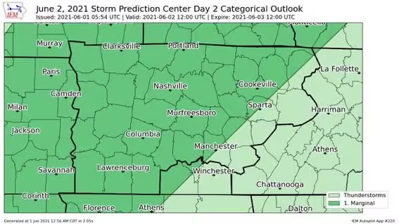
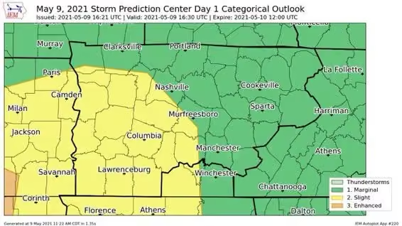
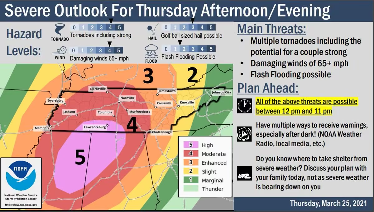
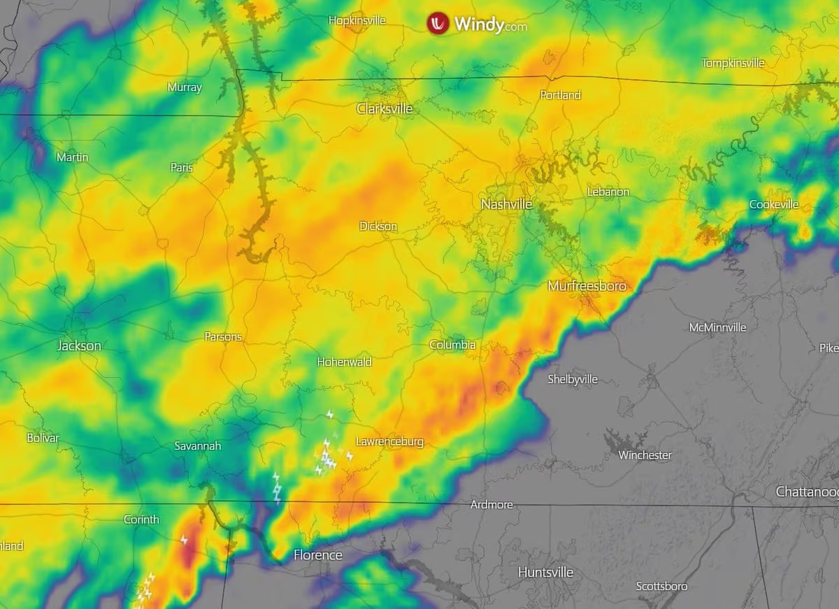
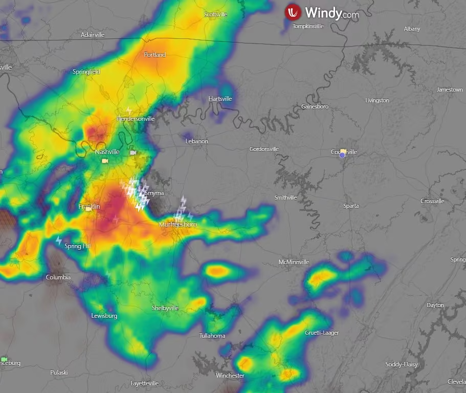
Severe thunderstorms are possible this morning and afternoon, mainly for areas east of I-65. Primary threats will be damaging winds and large hail. A brief tornado or two cannot be ruled out.
Putnam County, Tennessee
Putnam County is a county located in the U.S. state of Tennessee. As of the 2020 census, the population was 79,854. Its county seat is Cookeville. Putnam County is part of the Cookeville, TN Micropolitan Statistical Area. More on Wikipedia
-
Putnam County Emergency Management Agency
@PutnamEMATN

-
Putnam County Emergency Management Agency
@PutnamEMATN
-
Putnam County Emergency Management Agency
@PutnamEMATN
Periods of heavy rain are expected Thursday into Friday. Isolated strong to severe thunderstorms possible Thursday afternoon/evening
-
Putnam County Emergency Management Agency
@PutnamEMATN
A test of the Outdoor Warning Sirens will be conducted at 10:00 a.m. today.
-
Putnam County Emergency Management Agency
@PutnamEMATN
A Flood Watch continues to be in effect until Noon today. Additional thunderstorms with heavy downpours will move across mid state region as morning hours progress. 1 to 2 inches of rainfall will be common in the watch area, but some locations could have more than 3 inches.
-
Putnam County Emergency Management Agency
@PutnamEMATN
Strong to severe storms are expected later this afternoon through early evening. The main threat will be heavy rainfall and damaging winds.
-
Putnam County Emergency Management Agency
@PutnamEMATN
We will see scattered thunderstorms this afternoon into the evening. Some could be severe with wind and heavy rain being the main concern.
-
Putnam County Emergency Management Agency
@PutnamEMATN
Strong to severe thunderstorms will be possible each day through Sunday. Main hazards will be damaging straight-line winds, hail, and heavy rain. Stay weather-aware this weekend, especially if you have outdoor plans!
Heat index values will be hot with values of 100 to 110 degrees -
Putnam County Emergency Management Agency
@PutnamEMATN
Strong to severe thunderstorms will be possible each day through Sunday. Main hazards will be damaging straight-line winds, hail, and heavy rain. Stay weather-aware this weekend, especially if you have outdoor plans!
Heat index values will be 105 to 115 today & Saturday. -
Putnam County Emergency Management Agency
@PutnamEMATN
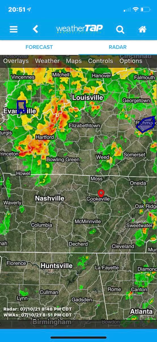
Severe storm cluster moving through West Kentucky could impact our area early afternoon.
60mph wind gusts and nickel-sized hail in current storms.
Timing and severity still somewhat uncertain so remain #weatheraware this afternoon. -
Putnam County Emergency Management Agency
@PutnamEMATN
Showers and thunderstorms are possible across the area today from late morning through the afternoon. A few of these may become strong to severe with damaging wind gusts of 60+ mph the main hazard. Stay weather-aware!
-
Putnam County Emergency Management Agency
@PutnamEMATN
Strong to severe storms are possible Thursday morning. Damaging wind gusts (60+ mph) will be possible.
-
Putnam County Emergency Management Agency
@PutnamEMATN
Boil Water Advisory for Livingston, North Overton, and West Overton water districts. No Putnam Co water district affected. Disregard emergency notification if not in one of these water districts.
-
Putnam County Emergency Management Agency
@PutnamEMATN
Brandon Smith Named Director of Emergency Management
www.instagram.com/p/Ct-ZH9qO3LP/ -
Putnam County Emergency Management Agency
@PutnamEMATN
Sunday's Severe Outlook: Strong to severe thunderstorms are possible starting Sunday evening and lasting into the overnight hours. All of Middle Tennessee has a chance for seeing strong storms, however areas along and north of I-40 have the greatest chance of seeing severe storms
-
Putnam County Emergency Management Agency
@PutnamEMATN
-
Putnam County Emergency Management Agency
@PutnamEMATN
Tyler Smith assumes new role in Emergency Management www.instagram.com/p/Ctu16IoMGAw/
-
Putnam County Emergency Management Agency
@PutnamEMATN
ENDANGERED CHILD ALERT - Memphis, TN
Tennessee Bureau of Investigation
@TBInvestigation
An #endangeredchildalert has been issued for 4yo Sequoia Samuels, missing from Memphis.
Sequoia was last seen earlier today near Caldwell Ave. in Memphis.
She was wearing a blue shirt & black pants w/hearts.
Tips? Call @MEM_PoliceDept at 901-636-4479 or 1-800-TBI-FIND.
1/2 -
Putnam County Emergency Management Agency
@PutnamEMATN
OUTDOOR WARNING SIREN TEST
Friday June 16th at 10am we will conduct a test of the outdoor warning sirens.
This test may include multiple brief sounds from different sirens. The test is part of our enhancement of backup activation processes.
The test will conclude by 10:15am. -
Putnam County Emergency Management Agency
@PutnamEMATN
Today's Severe Outlook: Mainly late afternoon through evening hours. Main Threat: Strong to damaging wind gusts (40 to 60 mph). Secondary Threats: Hail up to the size of quarters and isolated flash flooding in flood prone areas. Tornado threat is very low.
-
Putnam County Emergency Management Agency
@PutnamEMATN
Sunday's Severe Outlook: For late afternoon through evening hours. Some thunderstorms could reach strong to severe thresholds. Main threat will be strong to damaging wind gusts. Large hail will also be possible, especially for locations south of I-40 and west of I-65.
-
Putnam County Emergency Management Agency
@PutnamEMATN
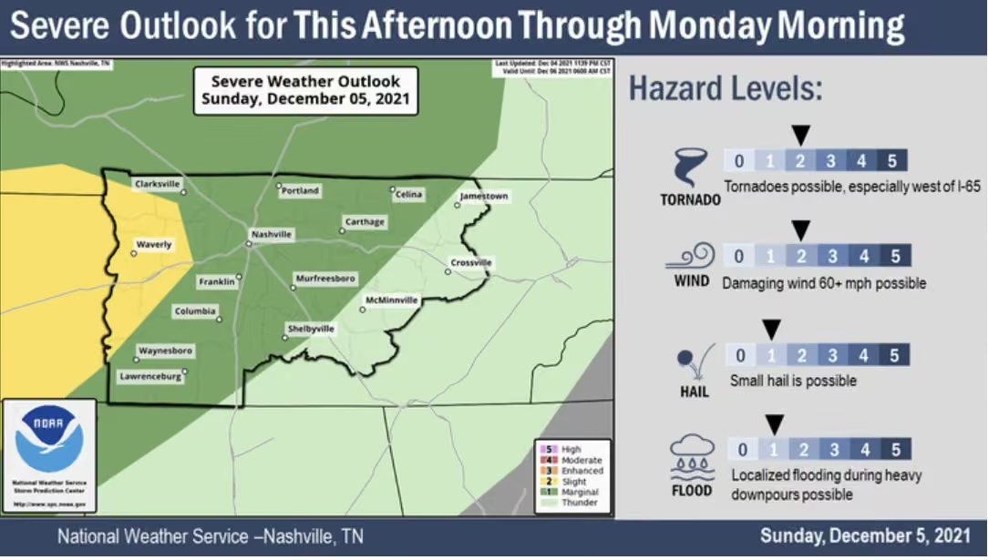
Sunday's Severe Outlook: For late afternoon through evening hours. Some thunderstorms could reach strong to severe thresholds. Main threat will be strong to damaging wind gusts. Small hail will also be possible.
-
Putnam County Emergency Management Agency
@PutnamEMATN
Updated threats for Sunday afternoon storms.
Damaging winds, heavy downpours leading to flash flooding, and hail all possible.
Timing remains early afternoon through early evening.
Stay #weatheraware and have multiple systems to receive warnings.
NWS Nashville
@NWSNashville
Scattered strong to severe storms are possible this afternoon, mainly after 1 PM. The main hazards will be strong straight-line winds, localized flash flooding, and hail. The *majority* of storms will be over after sunset, but storms could hang on through 10PM in the southeast.
-
Putnam County Emergency Management Agency
@PutnamEMATN
Sunday afternoon thunderstorms could produce severe damaging winds.
Multiple thunderstorms expected but widespread severe storms are not. Early afternoon to early evening is the most active, according to current models.
Stay #weatheraware Sunday -
Putnam County Emergency Management Agency
@PutnamEMATN
Special Weather Statement
-
Putnam County Emergency Management Agency
@PutnamEMATN
Thunderstorm coverage and intensity is expected to increase over the next few hours as the developing line of storms continues into central KY and northern middle TN. Damaging wind gusts are expected, with some chance for isolated hail and a brief tornado as well.
-
Putnam County Emergency Management Agency
@PutnamEMATN
Slight Risk (2/5) for severe storms has been issued for our area this afternoon and evening. The greatest risk is damaging winds, large hail, and heavy downpours.
Storms are possible this morning, but the strongest storms are possible between 2pm and 8pm for our area. -
Putnam County Emergency Management Agency
@PutnamEMATN
UPDATE 9:30am:
Due to the hard work of @myTDOT and the recovery companies, all Eastbound lanes of I-40 are open and flowing at highway speeds. -
Putnam County Emergency Management Agency
@PutnamEMATN
I-40 CLOSURE UPDATE 7:45am:
One Eastbound lane has reopened. One lane will remain closed until lunchtime. Estimated for both lanes to reopen around Noon. -
Putnam County Emergency Management Agency
@PutnamEMATN
I-40 CLOSURE
I-40 at the 288.5 mile marker Eastbound is closed due to a commercial vehicle rollover. Due to the contents of the trailers, cleanup will cause an extended delay in reopening all lanes. I-40 is estimated to be closed Eastbound until 9am. -
Putnam County Emergency Management Agency
@PutnamEMATN
An occasional, isolated strong thunderstorm is possible Sunday. Widespread severe storms are not expected, but an isolated storm could contain gusty winds, small hail, and brief heavy downpours.
Isolated storms can sneak up on you. Remember:
When Thunder Roars, Go Indoors! -
Putnam County Emergency Management Agency
@PutnamEMATN
Strong to severe thunderstorms possible Monday night.
Timing is after 6pm for our area and should end in the early overnight hours.
Risk 1/5. Damaging wind, large hail, and heavy downpours possible.
Have multiple systems to receive warnings and stay #weatheraware Monday night. -
Putnam County Emergency Management Agency
@PutnamEMATN
Strong Storms Sunday Afternoon and Overnight Sunday Night.
Strong damaging winds and large hail are the primary threat with any storms that develop.
Stay #weatheraware Sunday afternoon and overnight. Always have multiple systems to receive alerts. -
Putnam County Emergency Management Agency
@PutnamEMATN
Putnam County Alert:
Frost Advisory issued April 24 at 1:25PM CDT until April 25 at 8:00AM CDT by NWS Nashville TN -
Putnam County Emergency Management Agency
@PutnamEMATN
Putnam County Alert:
Frost Advisory issued April 23 at 2:17AM CDT until April 24 at 8:00AM CDT by NWS Nashville TN -
Putnam County Emergency Management Agency
@PutnamEMATN
Putnam County Alert:
Fire Weather Watch issued April 19 at 2:21PM CDT until April 20 at 7:00PM CDT by NWS Nashville TN -
Putnam County Emergency Management Agency
@PutnamEMATN
S. Jefferson Ave closed from Interstate Drive to E Veteran’s Dr due to commercial structure fire.
Southbound expected to open by 9pm. Northbound impacted for several hours.
Please avoid the area.
Image: @waze
Putnam County Emergency Management Agency
@PutnamEMATN
UPDATE 7:30pm: Due to the quick work of the Cookeville Fire Department, the fire is under control and all lanes of travel are open.
-
Putnam County Emergency Management Agency
@PutnamEMATN
UPDATE 7:30pm: Due to the quick work of the Cookeville Fire Department, the fire is under control and all lanes of travel are open.
-
Putnam County Emergency Management Agency
@PutnamEMATN
@NWSNashville has canceled the Severe Thunderstorm Watch. Gusty winds and heavy downpours possible but storms not expected to become severe.
Flood Watch remains in effect until Thursday 1pm for heavy rain overnight into Thursday.
When roads flood, Turn Around, Don’t Drown!
Putnam County Emergency Management Agency
@PutnamEMATN
Radar image credit @RadarOmega
-
Putnam County Emergency Management Agency
@PutnamEMATN
Putnam County Alert:
Flood Watch issued April 5 at 1:58PM CDT until April 6 at 1:00PM CDT by NWS Nashville TN -
Putnam County Emergency Management Agency
@PutnamEMATN
Putnam County Alert:
Severe Thunderstorm Watch issued April 5 at 1:38PM CDT until April 5 at 9:00PM CDT by NWS Nashville TN -
Putnam County Emergency Management Agency
@PutnamEMATN
Severe storms remain possible tonight but less likely and timing is now later in the night.
Now 5pm-1am timeframe, and severe threats focus more on hail, damaging winds, and heavy downpours. Tornado threat minimal.
Remain #weatheraware and have multiple systems to get alerts. -
Putnam County Emergency Management Agency
@PutnamEMATN
Strong to severe storms (2/5 Slight Risk) Wednesday afternoon and night. While storms are expected all evening and into overnight hours, the greatest threat is between 3pm and 8pm for the Plateau
Damaging winds and large hail possible - an isolated tornado cannot be ruled out. -
Putnam County Emergency Management Agency
@PutnamEMATN
Take time now to plan for emergencies in your business or workplace. Your customers and coworkers expect to be safe during an emergency. Spend time making sure that happens before the emergency arises.
Visit @SBAgov’s online resources, and contact our office if we can help. -
Putnam County Emergency Management Agency
@PutnamEMATN
Putnam County Alert:
Severe Thunderstorm Warning issued April 1 at 2:37AM CDT until April 1 at 3:15AM CDT by NWS Nashville TN -
Putnam County Emergency Management Agency
@PutnamEMATN
Putnam County Alert:
Severe Thunderstorm Warning issued April 1 at 2:14AM CDT until April 1 at 2:45AM CDT by NWS Nashville TN -
Putnam County Emergency Management Agency
@PutnamEMATN
Putnam County Alert:
Tornado Watch issued April 1 at 12:03AM CDT until April 1 at 7:00AM CDT by NWS Nashville TN -
Putnam County Emergency Management Agency
@PutnamEMATN
Dangerous afternoon and evening for our neighbors to the West. Please help spread the word.
-
Putnam County Emergency Management Agency
@PutnamEMATN
UPDATE FRIDAY 9am:
The SPC has increased our severe storm risk to Emhanced Risk (3/5) for severe storms tonight. Some wind gusts may reach 70mph at times. A Wind Advisory has been issued for Putnam County from 7pm Friday through 1pm Saturday. -
Putnam County Emergency Management Agency
@PutnamEMATN
Putnam County Alert:
Wind Advisory issued March 31 at 1:45AM CDT until April 1 at 1:00PM CDT by NWS Nashville TN -
Putnam County Emergency Management Agency
@PutnamEMATN
Severe storms possible Friday night into overnight hours.
NWS Nashville
@NWSNashville
Here's the latest on tomorrow night's severe weather. Please don't get hung up on the colors. If you are outlooked (and all of Middle TN is), then you have a chance for severe weather. Our main concern remains damaging straight-line winds with gusts 60+ mph. #tnwx
-
Putnam County Emergency Management Agency
@PutnamEMATN
Strong storms late Friday and overnight into Saturday.
Damaging winds and heavy downpours the primary threat. Hail and an isolated tornado can not be ruled out.
Currently a Slight Risk (2/5) issued by @NWSSPC.
Stay #weatheraware and connected for updates. -
Putnam County Emergency Management Agency
@PutnamEMATN
Putnam County Alert:
Frost Advisory issued March 28 at 8:36PM CDT until March 29 at 8:00AM CDT by NWS Nashville TN -
Putnam County Emergency Management Agency
@PutnamEMATN
Just posted a photo www.instagram.com/p/CqRmYyYOXE0/
-
Putnam County Emergency Management Agency
@PutnamEMATN
Putnam County Alert:
Severe Thunderstorm Warning issued March 24 at 11:26PM CDT until March 25 at 12:00AM CDT by NWS Nashville TN -
Putnam County Emergency Management Agency
@PutnamEMATN
Putnam County Alert:
Tornado Watch issued March 24 at 9:27PM CDT until March 25 at 3:00AM CDT by NWS Nashville TN -
Putnam County Emergency Management Agency
@PutnamEMATN
UPDATE 8:25PM: Westbound traffic was temporarily stopped to control a secondary fire. That fire is contained and Westbound traffic is moving but remains impacted.
I-40 remains closed at 271 Eastbound. -
Putnam County Emergency Management Agency
@PutnamEMATN
I-40 CLOSURE - 271 mile marker Eastbound
I-40 is shut down due to a semi fire at the 271 Eastbound. Traffic is impacted both directions with an unknown time to reopen.
The 271 mile marker is between the Smithville exit and Buffalo Valley exit. -
Putnam County Emergency Management Agency
@PutnamEMATN
Strong to severe storms remain likely overnight tonight (2am-6am). Storms expected to begin weakening as the enter the Cumberlnd Plateau but damaging winds, heavy downpours, hail, and an isolated tornado possible.
Stay #weatheraware and have multiple systems to alert you. -
Putnam County Emergency Management Agency
@PutnamEMATN
Putnam County Alert:
Wind Advisory issued March 24 at 12:24PM CDT until March 25 at 7:00AM CDT by NWS Nashville TN -
Putnam County Emergency Management Agency
@PutnamEMATN
Slight Risk (2/5) for severe storms overnight Friday into Saturday morning (2-6am for our area).
Heavy downpours and damaging winds are the main threat, but hail and an isolated tornado cannot be ruled out.
Stay #weatheraware as we move into the weekend. -
Putnam County Emergency Management Agency
@PutnamEMATN
Strong storms possible Friday night into overnight hours.
Currently a Slight Risk has been issued for our area.
Heavy downpours leading to flash flooding, damaging winds, hail are all possible, and an isolated tornado cannot be ruled out.
Stay #weatheraware Friday night -
Putnam County Emergency Management Agency
@PutnamEMATN
Putnam County Alert:
Freeze Warning issued March 20 at 2:48AM CDT until March 21 at 8:00AM CDT by NWS Nashville TN -
Putnam County Emergency Management Agency
@PutnamEMATN
Putnam County Alert:
Freeze Watch issued March 19 at 11:00AM CDT until March 21 at 8:00AM CDT by NWS Nashville TN -
Putnam County Emergency Management Agency
@PutnamEMATN
Putnam County Alert:
Freeze Warning issued March 18 at 10:06AM CDT until March 20 at 10:00AM CDT by NWS Nashville TN -
Putnam County Emergency Management Agency
@PutnamEMATN
Putnam County Alert:
Freeze Warning issued March 18 at 1:57AM CDT until March 19 at 10:00AM CDT by NWS Nashville TN -
Putnam County Emergency Management Agency
@PutnamEMATN
Putnam County Alert:
Freeze Warning issued March 17 at 1:40PM CDT until March 18 at 9:00AM CDT by NWS Nashville TN -
Putnam County Emergency Management Agency
@PutnamEMATN
Putnam County Alert:
Freeze Warning issued March 14 at 2:26AM CDT until March 15 at 10:00AM CDT by NWS Nashville TN -
Putnam County Emergency Management Agency
@PutnamEMATN
Putnam County Alert:
Freeze Warning issued March 13 at 2:19AM CDT until March 14 at 10:00AM CDT by NWS Nashville TN -
Putnam County Emergency Management Agency
@PutnamEMATN
Putnam County Alert:
Freeze Watch issued March 12 at 1:28PM CDT until March 14 at 9:00AM CDT by NWS Nashville TN -
Putnam County Emergency Management Agency
@PutnamEMATN
Putnam County Alert:
Severe Thunderstorm Warning issued March 3 at 1:00PM CST until March 3 at 1:30PM CST by NWS Nashville TN -
Putnam County Emergency Management Agency
@PutnamEMATN
Putnam County Alert:
Severe Thunderstorm Warning issued March 3 at 12:24PM CST until March 3 at 1:00PM CST by NWS Nashville TN -
Putnam County Emergency Management Agency
@PutnamEMATN
Putnam County Alert:
Tornado Watch issued March 3 at 10:34AM CST until March 3 at 4:00PM CST by NWS Nashville TN -
Putnam County Emergency Management Agency
@PutnamEMATN
High winds and severe storms today. A High Wind Warning has been issued until 6pm. Gusty winds up to 70mph possible.
Afternoon storms could bring damaging winds, heavy downpours, and isolated tornadoes.
Stay #weatheraware and have a plan.Post not available here, view on X
Putnam County Emergency Management Agency
@PutnamEMATN
✅Charge your phones and devices now
✅Check the batteries in your NOAA weather radio and ensure audible alerts are turned on
✅Download the Putnam EMA App
✅Sign up for emergency alerts at putnamcountytn.gov
✅Secure outdoor loose items
✅Have a plan - know your safe spot
Putnam County Emergency Management Agency
@PutnamEMATN
✅Have a plan - know your safe spot if a tornado warning is issued
🏠Get in center most portion of the house
🪖If you have one, put on a helmet
🛏️If you can, cover yourself with a matress
📺Stay tuned to local TV and radio for updates -
Putnam County Emergency Management Agency
@PutnamEMATN
High Wind Warning - not a common occurrence for Middle TN. Read more about this significant warning.
High Wind Warning valid until 6pm Friday March 3rd for Putnam County. -
Putnam County Emergency Management Agency
@PutnamEMATN
Putnam County Alert:
High Wind Warning issued March 2 at 2:09PM CST until March 3 at 6:00PM CST by NWS Nashville TN -
Putnam County Emergency Management Agency
@PutnamEMATN
Updated timing and severity for Friday storms.
Storm timing:
11am-3pm
Severity:
- Winds will be sustained at times at 30mph, with gusts up to 70mph ahead of storms.
- An Enhanced Risk (3/5) has been issued.
- Any storms that develop will have greater potential. -
Putnam County Emergency Management Agency
@PutnamEMATN
-
Putnam County Emergency Management Agency
@PutnamEMATN
Putnam County Alert:
Wind Advisory issued March 2 at 2:50AM CST until March 4 at 12:00AM CST by NWS Nashville TN -
Putnam County Emergency Management Agency
@PutnamEMATN
Putnam County Alert:
Flood Advisory issued March 1 at 9:29PM CST until March 2 at 12:30AM CST by NWS Nashville TN -
Putnam County Emergency Management Agency
@PutnamEMATN
Updated timing for Wednesday evening storms: 8pm-midnight. Risk category is variable but heavy downpours and gusty winds expected.
Additional storms possible Thursday night (8pm-midnight) and again Friday morning (9am-Noon).
Stay connected and #weatheraware -
Putnam County Emergency Management Agency
@PutnamEMATN
Severe storms with flash flooding and gusty, potentially damaging winds possible Wednesday evening. Storms are not expected to be widespread and any storms that develop are expected to be short-lived.
Stay #weatheraware the remainder of the week as storms are possible. -
Putnam County Emergency Management Agency
@PutnamEMATN
Putnam County Alert:
Wind Advisory issued February 26 at 2:19AM CST until February 27 at 6:00PM CST by NWS Nashville TN -
Putnam County Emergency Management Agency
@PutnamEMATN
Putnam County Alert:
Dense Fog Advisory issued February 26 at 2:19AM CST until February 26 at 9:00AM CST by NWS Nashville TN -
Putnam County Emergency Management Agency
@PutnamEMATN
Putnam County Alert:
Wind Advisory issued February 22 at 3:29AM CST until February 23 at 12:00AM CST by NWS Nashville TN -
Putnam County Emergency Management Agency
@PutnamEMATN
Putnam County Alert:
Dense Fog Advisory issued February 21 at 4:45AM CST until February 21 at 9:00AM CST by NWS Nashville TN -
Putnam County Emergency Management Agency
@PutnamEMATN
Tennessee's Severe Weather Awareness Week (SWAW) is Feb. 19-25, 2023, Now is the time to make severe weather planning and preparedness a priority.
www.weather.gov/ohx/swaw2023 -
Putnam County Emergency Management Agency
@PutnamEMATN
INTERSTATE CLOSURE
I-40 Eastbound at the 291 mile marker (just East of Cookeville - Hwy 70 exit 290) closed due to a crash.
Estimated to reopen by 1pm.
Photo: @waze screen capture -
Putnam County Emergency Management Agency
@PutnamEMATN
Multiple area roads flooded this morning. Watch for trees and limbs in roadways, and never cross standing water - Turn Around, Don’t Drown.
Report flooded roads or rain gauge readings here: arcg.is/0LGm8z
Photos: 1) Green Mountain Rd, 2) Poplar Grove Rd -
Putnam County Emergency Management Agency
@PutnamEMATN
Putnam County Alert:
Flood Advisory issued February 16 at 11:16PM CST until February 17 at 2:15AM CST by NWS Nashville TN -
Putnam County Emergency Management Agency
@PutnamEMATN
While some rain remains in our area, no significant or severe weather is expected to impact Putnam County overnight.
Some areas that have received higher amounts of rain may have minor flooding, but no additional flood threat is expected
Image: @RadarOmega -
Putnam County Emergency Management Agency
@PutnamEMATN
Putnam County Alert:
Severe Thunderstorm Warning issued February 16 at 6:16PM CST until February 16 at 6:45PM CST by NWS Nashville TN -
Putnam County Emergency Management Agency
@PutnamEMATN
Rain and storms have begun in our area. Severe storm potential remains but none are currently in our area. Stay weather aware as these storms are continuing to develop.
-
Putnam County Emergency Management Agency
@PutnamEMATN
Putnam County Alert:
Tornado Watch issued February 16 at 12:02PM CST until February 16 at 7:00PM CST by NWS Nashville TN -
Putnam County Emergency Management Agency
@PutnamEMATN
Severe storms chances remain throughout the morning but greatest risk is afternoon hours (3-6pm). We will continue to update throughout the day. Stay #weatheraware with
✅ NOAA Wx Radio
✅ Download Putnam EMA App
✅ Sign up for local alerts
✅ Stay tuned to local media -
Putnam County Emergency Management Agency
@PutnamEMATN
Severe storms possible Wednesday night and again Thursday afternoon. Increased risk for severe storms Thursday afternoon. Damaging winds, heavy downpours with flash flooding, and isolated tornadoes all possible.
Stay #weatheraware Weds and Thurs. -
Putnam County Emergency Management Agency
@PutnamEMATN
Some strong storms will be possible late Wednesday night mainly along and west of I-65. Another round of potentially strong storms will be possible on Thursday ahead of a cold front. Strong winds will be a threat during both time periods, a isolated tornado can`t be ruled out.
-
Putnam County Emergency Management Agency
@PutnamEMATN
Putnam County Alert:
Wind Advisory issued February 13 at 2:32PM CST until February 15 at 6:00AM CST by NWS Nashville TN -
Putnam County Emergency Management Agency
@PutnamEMATN
We are so proud of, and thankful for, our friend Melanie Bussell! She does so much for our community, and is among the first to step up to help during times of emergency. Congratulations, @BussellmBussell, @PCSSTN Supervisor of the Year!!!
Putnam County School System
@PCSSTN
The PCSS names Melanie Bussell, Response to Intervention (RTI) Supervisor, as the 2022-23 Supervisor of the Year!
Congratulations!
#pcss #putnamcountyschoolsystem #putnamcounty #putnamproud #supervisoroftheyear -
Putnam County Emergency Management Agency
@PutnamEMATN
Putnam County Alert:
Wind Advisory issued February 8 at 2:34AM CST until February 9 at 12:00PM CST by NWS Nashville TN -
Putnam County Emergency Management Agency
@PutnamEMATN
We appreciate @NWSNashville’s @MIC_Krissy and @JoshBWx for spending their morning teaching Wx radar skills to emergency services coordinators in the Emergency Operations Center. A great day of training and collaboration in preparation for severe weather season.
-
Putnam County Emergency Management Agency
@PutnamEMATN
With pockets of freezing rain and snow mix this morning, bridges and overpasses in the Monterey area are reported as slick and mixed precipitation is expected until approximately 9am.
Please allow extra travel time this morning. -
Putnam County Emergency Management Agency
@PutnamEMATN
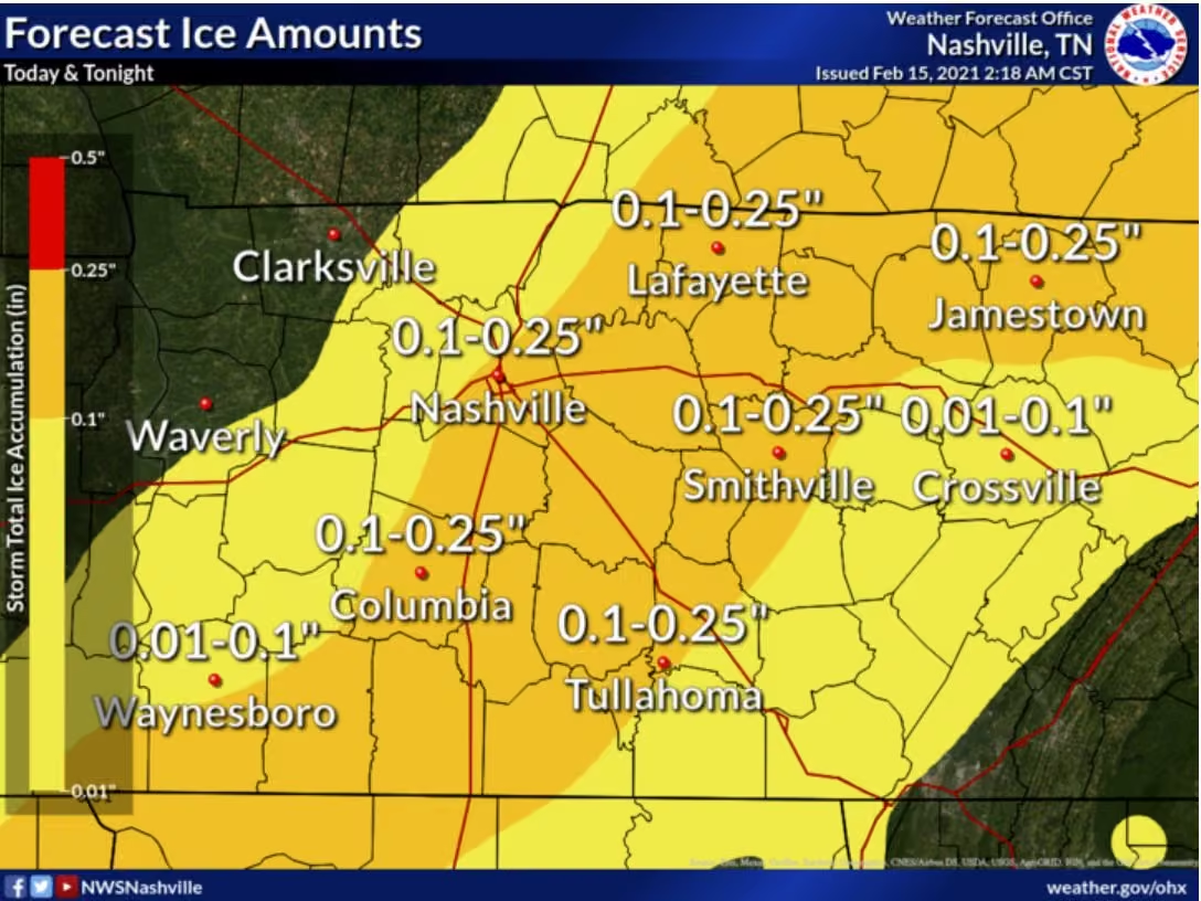
Another round of light freezing rain and sleet, along with some light snow, will spread across Middle Tennessee this evening into tonight. An additional light glaze of ice could occur in some areas, especially west of I-65, but no significant impacts are expected.
-
Putnam County Emergency Management Agency
@PutnamEMATN
WINTER WEATHER ADVISORY 6 PM THRU 6 AM CST WEDNESDAY
* WHAT...Freezing Rain expected. Ice accumulation of one tenth to two tenths of an inch.
* WHERE...Portions of Middle Tennessee.
* WHEN...From 6 PM thru 6 AM CST Wednesday.
* IMPACTS...Plan on slippery road conditions. -
Putnam County Emergency Management Agency
@PutnamEMATN
-
Putnam County Emergency Management Agency
@PutnamEMATN
Putnam County Alert:
Winter Weather Advisory issued January 31 at 2:29AM CST until February 1 at 11:00AM CST by NWS Nashville TN -
Putnam County Emergency Management Agency
@PutnamEMATN
Putnam County Alert:
Dense Fog Advisory issued January 30 at 9:42PM CST until January 31 at 9:00AM CST by NWS Nashville TN -
Putnam County Emergency Management Agency
@PutnamEMATN
Putnam County Alert:
Wind Advisory issued January 23 at 2:08PM CST until January 25 at 3:00PM CST by NWS Nashville TN -
Putnam County Emergency Management Agency
@PutnamEMATN
Putnam County Alert:
Wind Advisory issued January 19 at 9:22AM CST until January 19 at 6:00PM CST by NWS Nashville TN -
Putnam County Emergency Management Agency
@PutnamEMATN
Putnam County Alert:
Wind Advisory issued January 18 at 1:57PM CST until January 19 at 6:00AM CST by NWS Nashville TN -
Putnam County Emergency Management Agency
@PutnamEMATN
Showers and a few thunderstorms are expected across Middle Tennessee tonight. A few storms could be strong to marginally severe between 6
pm and midnight, mainly west of I-65. The main concern is strong gusty winds of 45 to 60 mph. -
Putnam County Emergency Management Agency
@PutnamEMATN
A few strong to severe storms could develop Wednesday afternoon and evening as a cold front pushes into the region. Damaging winds
and heavy rainfall are the primary concerns, but small hail and a brief tornado or two cannot be ruled out. -
Putnam County Emergency Management Agency
@PutnamEMATN
Putnam County Alert:
Winter Weather Advisory issued January 12 at 2:25PM CST until January 14 at 6:00AM CST by NWS Nashville TN -
Putnam County Emergency Management Agency
@PutnamEMATN
UPDATE 6:30am Thursday
The Storm Prediction Center has increased the risk category from level 1/5 to level 2/5 (Slight Risk) for severe storms through morning and mid-day.
Damaging winds are the primary threat with occasional large hail, and an isolated tornado is possible. -
Putnam County Emergency Management Agency
@PutnamEMATN
Severe thunderstorms are possible today. Hazards include damaging winds, large hail, and possibly a couple of tornadoes. Most of the storms will occur in the morning, but a few will last through the afternoon, especially east of I-65.
-
Putnam County Emergency Management Agency
@PutnamEMATN
A Slight Risk (level 1/5) of strong to severe thunderstorms is possible Thursday (Jan 12) mainly during the midday and afternoon hours.
Damaging wind gusts and an isolated tornado are possible.
Stay #weatheraware Thursday and have multiple systems to receive alerts. -
Putnam County Emergency Management Agency
@PutnamEMATN
Severe Weather Update - 5pm
We are not clear yet. The highest likelihood of more severe storms exists after dark and again in the 2-4am timeframe for our area.
Please state #weatheraware and have multiple systems to receive alerts. -
Putnam County Emergency Management Agency
@PutnamEMATN
Putnam County Alert:
Severe Thunderstorm Warning Severe Thunderstorm Warning issued January 3 at 12:09PM CST until January 3 at 1:00PM CST by NWS Nashville TN -
Putnam County Emergency Management Agency
@PutnamEMATN
Putnam County Alert:
Severe Thunderstorm Warning Severe Thunderstorm Warning issued January 3 at 11:32AM CST until January 3 at 12:15PM CST by NWS Nashville TN -
Putnam County Emergency Management Agency
@PutnamEMATN
Putnam County Alert:
Tornado Watch Tornado Watch issued January 3 at 9:16AM CST until January 3 at 5:00PM CST by NWS Nashville TN -
Putnam County Emergency Management Agency
@PutnamEMATN
Severe storm chances increased for Tuesday (level 2 of 5). Damaging winds, flash flooding, and isolated tornadoes are possible all day and evening Tuesday. Storms are also possible Monday evening and early Tuesday AM for areas West of Nashville. Stay #weatheraware
-
Putnam County Emergency Management Agency
@PutnamEMATN
Strong Storms Tuesday, with heavy downpours, damaging wind gusts, and isolated tornadoes possible (level 1 of 5 risk). Stay #weatheraware and have multiple systems to receive alerts. Visit www.putnamcountytn.gov to sign up for emergency alerts.
-
Putnam County Emergency Management Agency
@PutnamEMATN
UPDATE 2:15pm:
I-40 has reopened from the previous closure at the 295 Eastbound. Traffic in the affected area is beginning to flow normally, and the backup is clearing. -
Putnam County Emergency Management Agency
@PutnamEMATN
I-40 CLOSURE
I-40 eastbound at the 295 mile marker is current shut down due to a vehicle collision. The duration of the closure is unknown at this time.
Please seek an alternate route if possible and give responders a safe environment to work -
Putnam County Emergency Management Agency
@PutnamEMATN
Putnam County Alert:
Dense Fog Advisory Dense Fog Advisory issued December 31 at 9:20PM CST until January 1 at 9:00AM CST by NWS Nashville TN -
Putnam County Emergency Management Agency
@PutnamEMATN
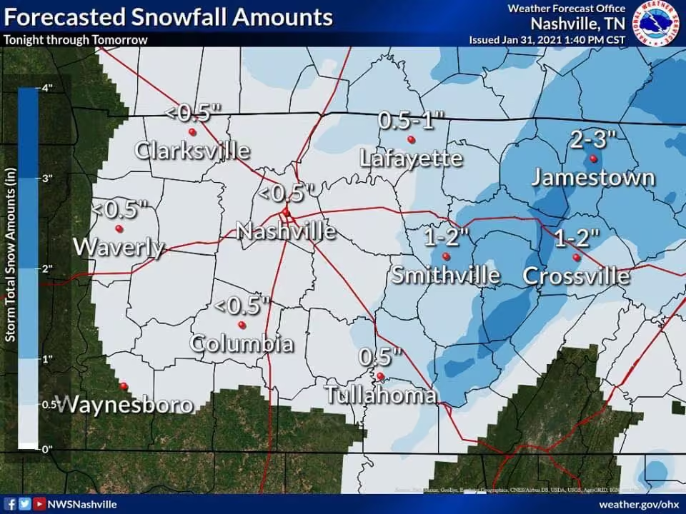
Light accumulating snow possible Monday. Light morning snow will linger into the afternoon on Monday, with accumulation up to 0.5” possible. Snowfall is expected to remain light.
Temperature may remain at or below freezing until Tuesday for our area.
NWS Nashville
@NWSNashville
A weak disturbance on Monday will bring one last burst of snow before our warm up. Accumulations are expected to be light with locations generally north of I-40 seeing the best chance of maybe around 0.5". #tnwx
-
Putnam County Emergency Management Agency
@PutnamEMATN
Putnam County Emergency Management Agency wishes you and your family a Merry Christmas!
-
Putnam County Emergency Management Agency
@PutnamEMATN
Putnam County Alert:
Wind Chill Advisory Wind Chill Advisory issued December 24 at 12:05PM CST until December 24 at 6:00PM CST by NWS Nashville TN -
Putnam County Emergency Management Agency
@PutnamEMATN
Message from TVA
Tennessee Valley Authority
@TVAnews
We are asking for everyone’s help in ensuring the power grid remains stable for us all.
-
Putnam County Emergency Management Agency
@PutnamEMATN
Due to extremely low temps across the region, TVA has implemented a mandatory load reduction for all Local Power Companies. Cookeville Electric Department will begin reducing loads using rolling blackouts. Customers may experience 15-30 minute outages until TVA cancels the order.
-
Putnam County Emergency Management Agency
@PutnamEMATN
Putnam County Alert:
Wind Chill Advisory Wind Chill Advisory issued December 23 at 1:23AM CST until December 24 at 12:00PM CST by NWS Nashville TN -
Putnam County Emergency Management Agency
@PutnamEMATN
Putnam County Alert:
Winter Storm Warning Winter Storm Warning issued December 22 at 2:35PM CST until December 23 at 6:00AM CST by NWS Nashville TN -
Putnam County Emergency Management Agency
@PutnamEMATN
Dangerously cold temperatures are expected across Middle Tennessee tonight. Avoid outside activities if possible. When outside, make sure you wear appropriate clothing, a hat, and gloves.
Slow down and use caution while traveling.
www.weather.gov/safety/cold -
Putnam County Emergency Management Agency
@PutnamEMATN
Putnam County Alert:
Winter Weather Advisory Winter Weather Advisory issued December 21 at 2:42PM CST until December 23 at 6:00AM CST by NWS Nashville TN -
Putnam County Emergency Management Agency
@PutnamEMATN
Putnam County Alert:
Wind Chill Warning Wind Chill Warning issued December 21 at 2:19AM CST until December 23 at 12:00PM CST by NWS Nashville TN -
Putnam County Emergency Management Agency
@PutnamEMATN
Putnam County Alert:
Wind Chill Watch Wind Chill Watch issued December 20 at 9:49AM CST until December 23 at 3:00PM CST by NWS Nashville TN -
Putnam County Emergency Management Agency
@PutnamEMATN
With bitterly cold temperatures expected beginning on Friday through the holiday week, remember the 4 P's for cold weather.
www.weather.gov/safety/cold -
Putnam County Emergency Management Agency
@PutnamEMATN
Confidence continues to increase that a significant dangerous cold air outbreak will occur across mid state region as Thursday Night through Christmas Day. Coldest Wind Chill Values are expected to be experienced just before sunrise on Friday.
-
Putnam County Emergency Management Agency
@PutnamEMATN
..FLOOD WATCH IN EFFECT THROUGH LATE TONIGHT...
* WHAT...Flooding caused by excessive rainfall is possible.
* WHERE...A portion of Middle Tennessee, including the following
counties, Cumberland, Putnam and White.
* WHEN...Through late tonight. -
Putnam County Emergency Management Agency
@PutnamEMATN
Putnam County Alert:
Dense Fog Advisory Dense Fog Advisory issued December 9 at 7:56PM CST until December 10 at 9:00AM CST by NWS Nashville TN -
Putnam County Emergency Management Agency
@PutnamEMATN
Showers and scattered thunderstorms could produce some localized flooding of mainly low lying and poorly drained areas thru the late afternoon. Showers and thunderstorms will be likely again Thursday through early Friday morning. Heavy downpours could cause some brief, flooding.
-
Putnam County Emergency Management Agency
@PutnamEMATN
Putnam County Alert:
Flood Advisory Flood Advisory issued December 7 at 11:51AM CST until December 7 at 3:00PM CST by NWS Nashville TN -
Putnam County Emergency Management Agency
@PutnamEMATN
Significant chance for heavy rainfall this week, possibly leading to localized flooding. Stay connected as patterns are not 100% certain, so predictions could change as the week unfolds.
Stay #weatheraware this week -
Putnam County Emergency Management Agency
@PutnamEMATN
Severe thunderstorms will be possible this evening, mainly 8 PM to 3 AM and mainly west of I-65. Damaging winds will be the greatest threat. A tornado cannot be ruled out.
-
Putnam County Emergency Management Agency
@PutnamEMATN
-
Putnam County Emergency Management Agency
@PutnamEMATN
ENDANGERED CHILD ALERT - Robertson County, TN
Tennessee Bureau of Investigation
@TBInvestigation
An Endangered Child Alert has been issued on behalf of the Robertson County Sheriff’s Office for 2-year-old Aurora Meyer.
She was last seen on Sunday wearing a Minnie Mouse jumpsuit.
Spot her? Call the Robertson County SO at 615-384-4911 or the TBI at 1-800-TBI-FIND. -
Putnam County Emergency Management Agency
@PutnamEMATN
On this Veteran's Day, we honor those who have so bravely served this country. Please remember the sacrifices of the brave men and women who have fought to make America the greatest nation on Earth.
-
Putnam County Emergency Management Agency
@PutnamEMATN
I-40 SHUT DOWN - 275 EASTBOUND
Interstate-40 is shut down, due to a critical crash, at the 275 Eastbound. Estimated to be reopened by 9pm. -
Putnam County Emergency Management Agency
@PutnamEMATN
Putnam County Alert:
Wind Advisory Wind Advisory issued November 4 at 1:56PM CDT until November 5 at 4:00PM CDT by NWS Nashville TN -
Putnam County Emergency Management Agency
@PutnamEMATN
Did you hear the outdoor warning sirens today? There is no emergency - we are completing testing of the new alerting programming in our system.
-
Putnam County Emergency Management Agency
@PutnamEMATN
A test of the Outdoor Warning Sirens will be conducted at 10:00 a.m. today.
-
Putnam County Emergency Management Agency
@PutnamEMATN
A few severe storms are possible this afternoon through the early evening. Damaging winds will be the main threat, but a tornado cannot be completely ruled out.
-
Putnam County Emergency Management Agency
@PutnamEMATN
A few severe storms are possible Tuesday afternoon through the early evening. Damaging winds will be the main threat, but a tornado cannot be completely ruled out.
-
Putnam County Emergency Management Agency
@PutnamEMATN
Putnam County Alert:
Freeze Warning Freeze Warning issued October 19 at 2:00PM CDT until October 20 at 9:00AM CDT by NWS Nashville TN -
Putnam County Emergency Management Agency
@PutnamEMATN
Putnam County Alert:
Freeze Warning Freeze Warning issued October 18 at 1:33AM CDT until October 19 at 9:00AM CDT by NWS Nashville TN -
Putnam County Emergency Management Agency
@PutnamEMATN
Putnam County Alert:
Freeze Warning Freeze Warning issued October 16 at 1:30PM CDT until October 18 at 9:00AM CDT by NWS Nashville TN -
Putnam County Emergency Management Agency
@PutnamEMATN
Putnam County Alert:
Freeze Watch Freeze Watch issued October 16 at 2:46AM CDT until October 18 at 9:00AM CDT by NWS Nashville TN -
Putnam County Emergency Management Agency
@PutnamEMATN
There is a slight risk for severe thunderstorms across Middle Tennessee today. A few storms could be severe with damaging winds the main threat. However, large hail and an isolated tornado is also possible. All storms should be out of the area by early Thursday morning.
-
Putnam County Emergency Management Agency
@PutnamEMATN
Putnam County Alert:
Frost Advisory Frost Advisory issued October 9 at 2:07PM CDT until October 10 at 8:00AM CDT by NWS Nashville TN -
Putnam County Emergency Management Agency
@PutnamEMATN
Putnam County Alert:
Frost Advisory Frost Advisory issued October 8 at 2:32AM CDT until October 9 at 9:00AM CDT by NWS Nashville TN -
Putnam County Emergency Management Agency
@PutnamEMATN
A test of the Outdoor Warning Sirens will be conducted at 10:00 a.m. today.
-
Putnam County Emergency Management Agency
@PutnamEMATN
Putnam County Alert:
Severe Thunderstorm Warning Severe Thunderstorm Warning issued September 25 at 3:34PM CDT until September 25 at 4:15PM CDT by NWS Nashville TN -
Putnam County Emergency Management Agency
@PutnamEMATN
EMERGENCY PREPAREDNESS EXPO
Sept 24,2022 from 10a.m. to 2p.m. at Life Church -
Putnam County Emergency Management Agency
@PutnamEMATN
Putnam County Alert:
Flood Watch Flood Watch issued September 4 at 2:30AM CDT until September 5 at 7:00PM CDT by NWS Nashville TN -
Putnam County Emergency Management Agency
@PutnamEMATN
Putnam County Alert:
Flood Advisory Flood Advisory issued September 4 at 1:18AM CDT until September 4 at 4:00AM CDT by NWS Nashville TN -
Putnam County Emergency Management Agency
@PutnamEMATN
Putnam County Alert:
Flood Advisory Flood Advisory issued September 3 at 11:23PM CDT until September 4 at 2:00AM CDT by NWS Nashville TN -
Putnam County Emergency Management Agency
@PutnamEMATN
Putnam County Alert:
Flash Flood Warning Flash Flood Warning issued September 3 at 10:29PM CDT until September 4 at 1:30AM CDT by NWS Nashville TN -
Putnam County Emergency Management Agency
@PutnamEMATN
Putnam County Alert:
Flood Advisory Flood Advisory issued September 3 at 9:41PM CDT until September 3 at 11:45PM CDT by NWS Nashville TN -
Putnam County Emergency Management Agency
@PutnamEMATN
A strong thunderstorm will impact portions of eastern De Kalb, north central Warren, northwestern White and southwestern Putnam Counties through 930 PM CDT [wind: 30 MPH, hail: 0.00 IN]
IEMBot OHX
@iembot_ohx
A strong thunderstorm will impact portions of eastern De Kalb, north central Warren, northwestern White and southwestern Putnam Counties through 930 PM CDT [wind: 30 MPH, hail: 0.00 IN] mesonet.agron.iastate.edu/p.php?pid=202209040202-KOHX-WWU…
-
Putnam County Emergency Management Agency
@PutnamEMATN
Showers and storms return for the week, with some potential for localized flash flooding Saturday afternoon and evening.
If roads are flooded, Turn Around, Don’t Drown, and talk to young drivers about the risks.
Stay #weatheraware and #readyputnam -
Putnam County Emergency Management Agency
@PutnamEMATN
Putnam County Alert:
Dense Fog Advisory Dense Fog Advisory issued August 31 at 4:51AM CDT until August 31 at 8:00AM CDT by NWS Nashville TN -
Putnam County Emergency Management Agency
@PutnamEMATN
ENDANGERED CHILD ALERT - Crossville, TN
Tennessee Bureau of Investigation
@TBInvestigation
An Endangered Child Alert has been issued on behalf of the Crossville Police Department for eight-y/o Kallie Jean Lynette Graham.
She was last seen in the front yard of her residence on 8/24 around 8 PM.
If you see Kallie, please call 931-484-2230, or 1-800-TBI-FIND. -
Putnam County Emergency Management Agency
@PutnamEMATN
A few strong to severe storms may be possible today. Especially this afternoon and evening. The main threat will be straight line
damaging winds. -
Putnam County Emergency Management Agency
@PutnamEMATN
Putnam County Alert:
Dense Fog Advisory Dense Fog Advisory issued August 17 at 7:10AM CDT until August 17 at 9:00AM CDT by NWS Nashville TN -
Putnam County Emergency Management Agency
@PutnamEMATN
Putnam County Alert:
Flood Advisory Flood Advisory issued August 10 at 1:12PM CDT until August 10 at 4:15PM CDT by NWS Nashville TN -
Putnam County Emergency Management Agency
@PutnamEMATN
Putnam County Alert:
Flood Advisory Flood Advisory issued August 7 at 5:27PM CDT until August 7 at 7:30PM CDT by NWS Nashville TN -
Putnam County Emergency Management Agency
@PutnamEMATN
Putnam County Alert:
Flood Advisory Flood Advisory issued August 5 at 2:48AM CDT until August 5 at 4:45AM CDT by NWS Nashville TN -
Putnam County Emergency Management Agency
@PutnamEMATN
Thunderstorms back in the forecast for a while. Afternoon thunderstorms on Tuesday could be strong, with damaging winds and heavy downpours the primary concern. A Marginal Risk of severe storms exists Tuesday.
Wednesday will be hot.
Stay #weatheraware this week. -
Putnam County Emergency Management Agency
@PutnamEMATN
Brandon Smith named first-ever Planning and Operations Chief.
Smith will oversee the County’s EOC, Emergency Alert System, GIS systems and more.
Serving with @Putnam911TN since 1999, @PutnamEMSTN, @PCFD_TN , and @PUTNAMRESCUE Smith brings 23 years experience to the new role. -
Putnam County Emergency Management Agency
@PutnamEMATN
A strong thunderstorm will impact Southeast Putnam County until 6:15pm. Wind gusts 30mph with 0.5” hail.
-
Putnam County Emergency Management Agency
@PutnamEMATN
Showers and storms return for the week in Middle Tennessee. Some storms may bring the possibility for gusty damaging winds and heavy downpours, and some storms potentially severe.
Stay #weatheraware this week for rain and thunderstorms -
Putnam County Emergency Management Agency
@PutnamEMATN
Putnam County Alert:
Heat Advisory Heat Advisory issued July 22 at 2:04PM CDT until July 23 at 7:00PM CDT by NWS Nashville TN -
Putnam County Emergency Management Agency
@PutnamEMATN
Putnam County Alert:
Flood Advisory Flood Advisory issued July 21 at 4:09AM CDT until July 21 at 7:15AM CDT by NWS Nashville TN -
Putnam County Emergency Management Agency
@PutnamEMATN
Putnam County Alert:
Severe Thunderstorm Warning Severe Thunderstorm Warning issued July 21 at 4:08AM CDT until July 21 at 4:45AM CDT by NWS Nashville TN -
Putnam County Emergency Management Agency
@PutnamEMATN
Putnam County Alert:
Severe Thunderstorm Warning Severe Thunderstorm Warning issued July 21 at 3:30AM CDT until July 21 at 4:15AM CDT by NWS Nashville TN -
Putnam County Emergency Management Agency
@PutnamEMATN
Putnam County Alert:
Flash Flood Warning Flash Flood Warning issued July 21 at 3:26AM CDT until July 21 at 6:30AM CDT by NWS Nashville TN -
Putnam County Emergency Management Agency
@PutnamEMATN
Putnam County Alert:
Severe Thunderstorm Warning Severe Thunderstorm Warning issued July 21 at 3:06AM CDT until July 21 at 3:45AM CDT by NWS Nashville TN -
Putnam County Emergency Management Agency
@PutnamEMATN
A cluster of strong thunderstorms is moving toward Putnam County. Currently, a severe-warmed thunderstorm is moving through Wilson, Dekalb, and Smith counties.
This storm is currently capable of producing 60 mph winds, intense lightning, 0.75 inch hail, and heavy downpours. -
Putnam County Emergency Management Agency
@PutnamEMATN
Another hot stretch and potential for some showers and storms Wednesday, some possibly strong to severe.
The main threat with any storms that develop is damaging winds and heavy downpours, primarily in the afternoon and evening.
Stay #weatheraware and take heat precautions. -
Putnam County Emergency Management Agency
@PutnamEMATN
Putnam County Alert:
Flood Advisory Flood Advisory issued July 18 at 12:08PM CDT until July 18 at 2:00PM CDT by NWS Nashville TN -
Putnam County Emergency Management Agency
@PutnamEMATN
Showers and thunderstorms possible Sunday. Some storms could be strong to severe, with damaging winds the primary threat, mainly in the afternoon and evening hours.
Stay #weatheraware Sunday -
Putnam County Emergency Management Agency
@PutnamEMATN
Putnam County Alert:
Severe Thunderstorm Warning Severe Thunderstorm Warning issued July 12 at 5:55PM CDT until July 12 at 6:45PM CDT by NWS Nashville TN -
Putnam County Emergency Management Agency
@PutnamEMATN
Putnam County Alert:
Severe Thunderstorm Warning Severe Thunderstorm Warning issued July 12 at 5:32PM CDT until July 12 at 6:15PM CDT by NWS Nashville TN -
Putnam County Emergency Management Agency
@PutnamEMATN
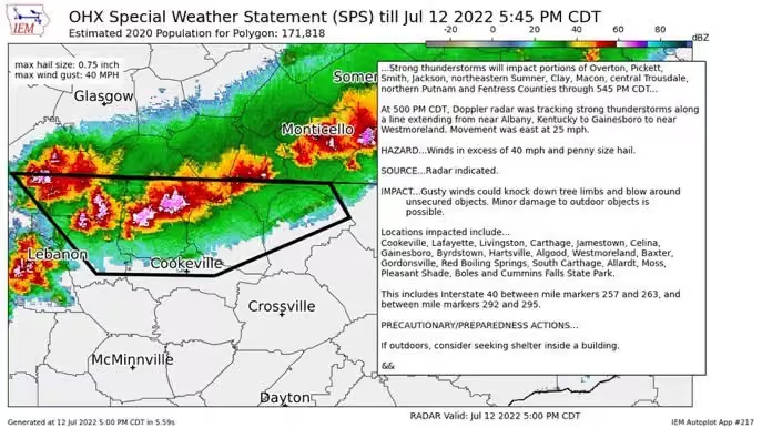
A strong thunderstorm is tracking over Putnam County. Currently 40mph wind gusts and 3/4 inch hail accompanies this storm.
Stay #weatheraware as storms are strengthening at this time. -
Putnam County Emergency Management Agency
@PutnamEMATN
Scattered showers and thunderstorms Tuesday and Wednesday with some storms becoming severe. Any storms that develop could bring damaging winds and brief heavy downpours.
Stay #weatheraware Tuesday and Wednesday. -
Putnam County Emergency Management Agency
@PutnamEMATN
Putnam County Alert:
Severe Thunderstorm Warning Severe Thunderstorm Warning issued July 8 at 3:47PM CDT until July 8 at 4:30PM CDT by NWS Nashville TN -
Putnam County Emergency Management Agency
@PutnamEMATN
A strong thunderstorm is approaching Putnam County. Wind gusts expected at 40mph and 0.25” hail with this storm.
-
Putnam County Emergency Management Agency
@PutnamEMATN
Putnam County Alert:
Severe Thunderstorm Warning Severe Thunderstorm Warning issued July 7 at 3:46PM CDT until July 7 at 4:30PM CDT by NWS Nashville TN -
Putnam County Emergency Management Agency
@PutnamEMATN
Putnam County Alert:
Severe Thunderstorm Warning Severe Thunderstorm Warning issued July 7 at 3:10PM CDT until July 7 at 3:45PM CDT by NWS Nashville TN -
Putnam County Emergency Management Agency
@PutnamEMATN
Putnam County Alert:
Severe Thunderstorm Warning Severe Thunderstorm Warning issued July 7 at 2:47PM CDT until July 7 at 3:30PM CDT by NWS Nashville TN -
Putnam County Emergency Management Agency
@PutnamEMATN
A dangerous combination of heat and humidity will continue. Excessive Heat Warnings or Heat Advisories are in place for most of the area.
Scattered thunderstorms are expected today. A few may be severe with damaging wind gusts. -
Putnam County Emergency Management Agency
@PutnamEMATN
Putnam County Alert:
Flood Advisory Flood Advisory issued July 6 at 4:32PM CDT until July 6 at 6:30PM CDT by NWS Nashville TN -
Putnam County Emergency Management Agency
@PutnamEMATN
**HEAT ADVISORY IN EFFECT UNTIL MIDNIGHT CDT FRIDAY NIGHT**
Heat index values reaching 105 to 110 each day. Hot temperatures and high humidity may cause heat
illnesses to occur.
Scattered thunderstorms are expected today. A few may be severe with damaging wind gusts. -
Putnam County Emergency Management Agency
@PutnamEMATN
Putnam County Alert:
Flood Advisory Flood Advisory issued July 3 at 2:40PM CDT until July 3 at 4:45PM CDT by NWS Nashville TN -
Putnam County Emergency Management Agency
@PutnamEMATN
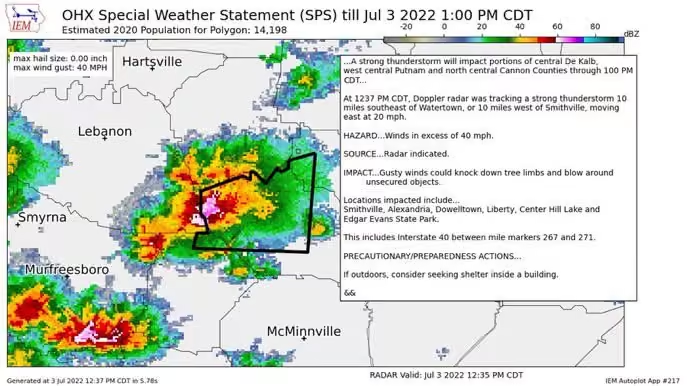
At 1237 PM CDT, Doppler radar was tracking a strong thunderstorm 10 miles southeast of Watertown, or 10 miles west of Smithville, moving east at 20 mph. HAZARD...Winds in excess of 40 mph. SOURCE...Radar indicated.
-
Putnam County Emergency Management Agency
@PutnamEMATN
!TENNESSEE BLUE ALERT!
Tennessee Bureau of Investigation
@TBInvestigation
🚨A #tnbluealert has been issued for Samuel Q Edwards, wanted by Metro Nashville PD and TBI for Attempted Criminal Homicide and Evading Arrest.
He should be considered armed and very dangerous.
Please call 1-800-TBI-FIND if you know where he is. -
Putnam County Emergency Management Agency
@PutnamEMATN
Thunderstorms are developing across the region and in Putnam County. Currently none of them are severe, but they can quickly intensify. Stay #weatheraware
Radar Image: @RadarOmega -
Putnam County Emergency Management Agency
@PutnamEMATN
Sunday afternoon and evening thunderstorms will be less scattered than Saturday storms. Some storms could become severe, with damaging winds and heavy downpours being the primary threat.
Stay #weatheraware Sunday and have multiple systems to receive warnings. -
Putnam County Emergency Management Agency
@PutnamEMATN
Putnam County Alert:
Severe Thunderstorm Warning Severe Thunderstorm Warning issued June 25 at 8:37PM CDT until June 25 at 9:15PM CDT by NWS Nashville TN -
Putnam County Emergency Management Agency
@PutnamEMATN
Scattered showers and thunderstorms expected Saturday afternoon. A marginal risk of a severe storm or two developing exists.
Storms not expected to be widespread on Saturday, but could produce strong damaging winds and brief heavy downpours.
Stay #weatheraware this weekend -
Putnam County Emergency Management Agency
@PutnamEMATN
A Test of the Outdoor Warning Sirens will be conducted today at 10:00 a.m.
-
Putnam County Emergency Management Agency
@PutnamEMATN
Putnam County Alert:
Severe Thunderstorm Watch Severe Thunderstorm Watch issued June 17 at 9:01AM CDT until June 17 at 2:00PM CDT by NWS Nashville TN -
Putnam County Emergency Management Agency
@PutnamEMATN
Showers and thunderstorms possible today (Friday). A marginal risk of storms becoming severe, with damaging winds and hail the primary threat in the afternoon hours.
Stay #weatheraware Friday afternoon -
Putnam County Emergency Management Agency
@PutnamEMATN
UPDATE: The roadway on Crossville Hwy and Hillwod Street is open and traffic is unobstructed.
-
Putnam County Emergency Management Agency
@PutnamEMATN
HWY 70 / CROSSVILLE HWY CLOSED AT HILLWOOD STREET (MONTEREY)
Critical crash causing closure of Hwy 70/Crossville Hey at Hollywood Street, just Southeast of Monterey.
Roadway expected to open by 5pm. -
Putnam County Emergency Management Agency
@PutnamEMATN
Heat Advisory extended until Thursday at 7pm. Index 105-110.
Please plan for the excessive heat:
👷♀️ Take regular breaks and hydrate
👼 Check the back seat for children and pets
🐶 Make sure pets have cool shelter and plenty of water
⛳️ Limit unnecessary outdoor activities -
Putnam County Emergency Management Agency
@PutnamEMATN
Putnam County Alert:
Heat Advisory Heat Advisory issued June 14 at 2:42AM CDT until June 15 at 7:00PM CDT by NWS Nashville TN -
Putnam County Emergency Management Agency
@PutnamEMATN
A Heat Advisory is in effect for our area until Tuesday at 7pm.
Plan for the heat:
👷♀️ Take regular breaks and hydrate
👼 Check the back seat for children and pets
🐶 Make sure pets have cool shelter and plenty of water
⛳️ Limit unnecessary outdoor activities -
Putnam County Emergency Management Agency
@PutnamEMATN
It’s going to be hot this week. A Heat Advisory has been issued to our West.
Stay hydrated, take plenty of breaks if outdoors, and take extra precautions for known health conditions.
Check out these tips from @NWSNashville -
Putnam County Emergency Management Agency
@PutnamEMATN
A slight chance of Sunday afternoon and evening thunderstorms exists.
If storms reach our area, heavy rain and gusty winds are the primary threat.
Storms are most likely in the late afternoon and early evening.
Stay #weatheraware Sunday evening. -
Putnam County Emergency Management Agency
@PutnamEMATN
Strong to severe storms possible Wednesday for our area.
The main threat is damaging winds, hail, and heavy downpours, and a tornado cannot be ruled out.
Heavy rain with these storms are likely to cause flooding in areas already saturated from previous rain.
Stay #weatheraware -
Putnam County Emergency Management Agency
@PutnamEMATN
Putnam County Alert:
Flash Flood Warning Flash Flood Warning issued June 7 at 5:43PM CDT until June 7 at 8:45PM CDT by NWS Nashville TN -
Putnam County Emergency Management Agency
@PutnamEMATN
Putnam County Alert:
Severe Thunderstorm Warning Severe Thunderstorm Warning issued June 7 at 5:28PM CDT until June 7 at 6:00PM CDT by NWS Nashville TN -
Putnam County Emergency Management Agency
@PutnamEMATN
Putnam County Alert:
Flood Advisory Flood Advisory issued June 7 at 5:19PM CDT until June 7 at 8:30PM CDT by NWS Nashville TN -
Putnam County Emergency Management Agency
@PutnamEMATN
Strong to severe storms possible Tuesday and Wednesday afternoon and evening.
Storms capable of producing flash flooding, damaging winds, small hail, and a tornado cannot be ruled out.
Stay #weatheraware and have multiple ways to receive alerts. -
Putnam County Emergency Management Agency
@PutnamEMATN
Strong to Severe Thunderstorms Tuesday Afternoon and Again Wednesday
Any storms that develop could quickly become strong or severe, with gusty winds, small hail, frequent lightning, and heavy downpours.
Stay #weatheraware Tuesday afternoon and Wednesday -
Putnam County Emergency Management Agency
@PutnamEMATN
Putnam County Alert:
Flood Advisory Flood Advisory issued June 7 at 4:58AM CDT until June 7 at 11:00AM CDT by NWS Nashville TN -
Putnam County Emergency Management Agency
@PutnamEMATN
Monday Evening Update from @NWSNashville
NWS Nashville
@NWSNashville
All of Middle Tennessee is under a marginal or slight risk of severe storms this evening and overnight. The latest short-range models continue to show storms re-developing during the evening and lasting into the overnight period. The primary risk is damaging straight-line winds.
-
Putnam County Emergency Management Agency
@PutnamEMATN
A few strong to severe thunderstorms are possible this afternoon to early evening and again overnight. The primary concern is damaging wind gusts. Small hail and isolated tornadoes cannot be ruled out. Localized flooding in flood-prone areas during heavy downpours is possible.
-
Putnam County Emergency Management Agency
@PutnamEMATN
WEATHER UPDATE 8am: Confidence continues to decrease concerning severe storm potential for Thursday afternoon. The @NWSSPC has decreased the risk for severe weather in our area, but some storms could still be strong if they develop this afternoon. Remain #weatheraware
-
Putnam County Emergency Management Agency
@PutnamEMATN
Rain and thunderstorms Thursday with some storms becoming strong to severe.
Any storms that develop Thursday may become strong to severe, with gusty winds and hail the concern.
A Marginal Risk for severe storms exists Thursday for our area.
Stay #weatheraware Thursday -
Putnam County Emergency Management Agency
@PutnamEMATN
-
Putnam County Emergency Management Agency
@PutnamEMATN
SPECIAL WEATHER STATEMENT
1:11 PM CDT THU MAY 26 2022
PUTNAM TN-DE KALB TN-SMITH TN-
111 PM CDT THU MAY 26 2022
...A STRONG THUNDERSTORM WILL IMPACT PORTIONS OF SOUTHEASTERN SMITH,
DE KALB AND SOUTHWESTERN PUTNAM COUNTIES THROUGH 145 PM CDT. -
Putnam County Emergency Management Agency
@PutnamEMATN
Marginal risk for strong to severe thunderstorms Thursday, with periods of heavy downpours possible. Damaging winds are possible with any afternoon/evening storms, and a tornado cannot be ruled out (though risk is very low).
Stay #weatheraware Thursday -
Putnam County Emergency Management Agency
@PutnamEMATN
Strong to severe thunderstorms possible Wednesday afternoon and evening.
Heavy downpours, damaging winds, and hail are the primary concerns with any storms that develop.
Stay #weatheraware Wednesday -
Putnam County Emergency Management Agency
@PutnamEMATN
A line of strong thunderstorms, moving East at 35ph, will reach Western Putnam County at approximately 9:45pm, and is expected to be in Cookeville around 10pm. Lighting, damaging winds, and small hail currently in these storms. Stay #weatheraware
Radar: @RadarOmega -
Putnam County Emergency Management Agency
@PutnamEMATN
Heavy showers and thunderstorms expected Saturday night.
Some storms may become severe overnight into Sunday morning.
Heavy downpours, damaging winds, and hail are the primary threats with any storms.
Stay #weatheraware and have multiple ways to get warnings overnight. -
Putnam County Emergency Management Agency
@PutnamEMATN
Strong to Severe Storms Possible Wednesday
Afternoon and evening thunderstorms on Wednesday could become severe.
Damaging winds and hail are the primary threats with any storms that develop.
Stay #weatheraware Wednesday -
Putnam County Emergency Management Agency
@PutnamEMATN
A few strong storms possible Sunday afternoon and evening. Some storms could bring heavy downpours, hail, and damaging winds.
The greatest risk is West of Nashville, but some strong to severe storms could develop in our area as well.
Stay #weatheraware Sunday -
Putnam County Emergency Management Agency
@PutnamEMATN
Putnam County Alert:
Flood Advisory Flood Advisory issued May 13 at 7:38PM CDT until May 13 at 9:30PM CDT by NWS Nashville TN -
Putnam County Emergency Management Agency
@PutnamEMATN
Just posted a photo www.instagram.com/p/CdhIzwEuhnL/
-
Putnam County Emergency Management Agency
@PutnamEMATN
Putnam County Alert:
Severe Thunderstorm Warning Severe Thunderstorm Warning issued May 6 at 1:57PM CDT until May 6 at 2:30PM CDT by NWS Nashville TN -
Putnam County Emergency Management Agency
@PutnamEMATN
Strong and severe storms possible Friday.
Late morning and early afternoon bring the best chances of storms developing, with a Slight Risk (level 2 of 5) of severe storms issued by the @NWSSPC
Stay #weatheraware Friday and have multiple ways to receive alerts. -
Putnam County Emergency Management Agency
@PutnamEMATN
‼️UPDATE - FOUND SAFE‼️
MR. Johnson has been found safe. Thank you for your assistance sharing the message. -
Putnam County Emergency Management Agency
@PutnamEMATN
Putnam County Alert:
Severe Thunderstorm Warning Severe Thunderstorm Warning issued May 5 at 6:40PM CDT until May 5 at 7:15PM CDT by NWS Nashville TN -
Putnam County Emergency Management Agency
@PutnamEMATN
Severe storms possible Thursday and Friday.
Thursday afternoon and evening severe storms are possible with damaging winds the primary threat. Hail, heavy downpours, and a tornado cannot be ruled out.
Stay #weatheraware as some storms may develop and intensify quickly. -
Putnam County Emergency Management Agency
@PutnamEMATN
Thursday and Friday contain a risk of severe thunderstorms.
The @NWSSPC has issued a Marginal Risk for storm development Thursday night, with some storms possibly severe. Damaging winds, hail, and heavy downpours are the primary threat, but a tornado cannot be ruled out. -
Putnam County Emergency Management Agency
@PutnamEMATN
Storm chances and intensity expected to increase throughout this afternoon and evening. Some storms may become severe.
The @NWSSPC has issued a Marginal Risk (level 1 of 5) for severe storms today.
Stay #weatheraware as storms develop.
Radar Image: @RadarOmega -
Putnam County Emergency Management Agency
@PutnamEMATN
Did you know lightning can strike several miles ahead of a storm? Most often after thunder is heard. 11 people died in 2021 and hundreds injured by lightning strikes. With storms possible this week - take time to learn about lightning safety.
www.weather.gov/safety/lightning -
Putnam County Emergency Management Agency
@PutnamEMATN
Showers and thunderstorms Monday. As the afternoon goes on some storms could intensify and produce damaging winds.
The @NWSSPC has issued a Marginal Risk for storm development Monday in our area.
Stay #weatheraware Monday. -
Putnam County Emergency Management Agency
@PutnamEMATN
Putnam County Alert:
Frost Advisory Frost Advisory issued April 18 at 10:42PM CDT until April 19 at 9:00AM CDT by NWS Nashville TN -
Putnam County Emergency Management Agency
@PutnamEMATN
Do you have damage from Wednesday night storms? Please use the survey link to report storm damage. If you have emergency needs, please call 911 (this form is not used to get emergency response).
arcg.is/18i5ie -
Putnam County Emergency Management Agency
@PutnamEMATN
Putnam County Alert:
Severe Thunderstorm Warning Severe Thunderstorm Warning issued April 13 at 9:25PM CDT until April 13 at 10:00PM CDT by NWS Nashville TN -
Putnam County Emergency Management Agency
@PutnamEMATN
Putnam County Alert:
Severe Thunderstorm Warning Severe Thunderstorm Warning issued April 13 at 8:53PM CDT until April 13 at 9:30PM CDT by NWS Nashville TN -
Putnam County Emergency Management Agency
@PutnamEMATN
A strong thunderstorm is moving into Putnam County, capable of producing damaging winds. This line of storms has produced downed trees and powerlines as it moved across the mid-state.
Stay #weatheraware and have multiple warning systems as these storms move into our area. -
Putnam County Emergency Management Agency
@PutnamEMATN
Putnam County Alert:
Severe Thunderstorm Warning Severe Thunderstorm Warning issued April 13 at 8:24PM CDT until April 13 at 9:00PM CDT by NWS Nashville TN -
Putnam County Emergency Management Agency
@PutnamEMATN
Updated timing for tonight’s severe storm potential:
Storms will develop to the West and are expected to gradually weaken as they push East into our area. All forms of severe weather remain possible for our area, and are most likely 10pm-1am tonight.
Stay #weatheraware -
Putnam County Emergency Management Agency
@PutnamEMATN
Severe storms remain possible tonight. 5pm-1am is the main timeline, and all forms of severe weather are possible with storms that develop.
Stay #weatheraware and have multiple systems to receive alerts, especially after you go to sleep. -
Putnam County Emergency Management Agency
@PutnamEMATN
Severe thunderstorms possible overnight Wednesday night. Damaging winds, tornadoes, hail, and heavy downpours all possible overnight into Thursday morning.
Stay #weatheraware and #readyputnam and always have multiple systems to receive warnings. -
Putnam County Emergency Management Agency
@PutnamEMATN
Putnam County Alert:
Freeze Warning Freeze Warning issued April 9 at 2:09PM CDT until April 10 at 8:00AM CDT by NWS Nashville TN -
Putnam County Emergency Management Agency
@PutnamEMATN
Putnam County Alert:
Frost Advisory Frost Advisory issued April 8 at 2:44PM CDT until April 9 at 7:00AM CDT by NWS Nashville TN -
Putnam County Emergency Management Agency
@PutnamEMATN
Severe thunderstorms will be possible today, mainly during the afternoon hours. The main threat with any severe storms will be damaging winds, but cannot rule out an isolated tornado or two, especially on the Cumberland Plateau.
-
Putnam County Emergency Management Agency
@PutnamEMATN
Severe thunderstorms will be possible today, mainly during the late morning to afternoon hours. The main threat with any severe storms will be damaging winds, but cannot rule out an isolated tornado or two.
-
Putnam County Emergency Management Agency
@PutnamEMATN
Putnam County Alert:
Dense Fog Advisory Dense Fog Advisory issued April 6 at 12:02AM CDT until April 6 at 5:00AM CDT by NWS Nashville TN -
Putnam County Emergency Management Agency
@PutnamEMATN
Strong to severe thunderstorms possible Wednesday afternoon and evening. @NWSSPC has issued a Slight Risk for severe storms for our area.
Damaging winds and hail possible, and a tornado cannot be ruled out.
Stay #weatheraware and #readyputnam -
Putnam County Emergency Management Agency
@PutnamEMATN
Strong to Severe Storms Possible Wednesday.
The primary threat is damaging winds, but tornadoes cannot be ruled out. These storms will mainly occur in the afternoon and evening hours.
Stay #weatheraware and #readyputnam, and always have multiple systems to receive alerts. -
Putnam County Emergency Management Agency
@PutnamEMATN
Putnam County Alert:
Frost Advisory Frost Advisory issued April 1 at 3:44AM CDT until April 2 at 8:00AM CDT by NWS Nashville TN -
Putnam County Emergency Management Agency
@PutnamEMATN
Putnam County Alert:
Severe Thunderstorm Watch Severe Thunderstorm Watch issued March 30 at 11:03PM CDT until March 31 at 4:00AM CDT by NWS Nashville TN -
Putnam County Emergency Management Agency
@PutnamEMATN
Severe storms remain possible but the main line is weakening as predicted. Gusty winds are still causing damage across the state, and heavy downpours are expected as the main line moves through. Stay #weatheraware as these storms push East.
-
Putnam County Emergency Management Agency
@PutnamEMATN
Strong to severe thunderstorms are possible this afternoon into
this evening. Damaging winds primary threat, but tornadoes are
also possible.
In addition to thunderstorms, non-thunderstorm wind gusts up
to 55 MPH are expected mid morning hours today through this
evening. -
Putnam County Emergency Management Agency
@PutnamEMATN
*Severe storms are possible Wednesday afternoon and evening.*
Strong winds throughout the day (gusts upwards of 50 to 55 mph possible). Strong to severe thunderstorms in the afternoon and evening, with the main concern being damaging wind gusts. Isolated tornadoes also possible -
Putnam County Emergency Management Agency
@PutnamEMATN
Putnam County Alert:
Wind Advisory Wind Advisory issued March 29 at 3:36AM CDT until March 31 at 1:00AM CDT by NWS Nashville TN -
Putnam County Emergency Management Agency
@PutnamEMATN
Strong to severe storms are possible on Wednesday afternoon and evening.
-
Putnam County Emergency Management Agency
@PutnamEMATN
A test of the Outdoor Warning Sirens will be conducted at 10:00 a.m. today.
-
Putnam County Emergency Management Agency
@PutnamEMATN
Putnam County Alert:
Wind Advisory Wind Advisory issued March 23 at 12:06PM CDT until March 23 at 7:00PM CDT by NWS Nashville TN -
Putnam County Emergency Management Agency
@PutnamEMATN
Putnam County Alert:
Wind Advisory Wind Advisory issued March 22 at 2:41AM CDT until March 22 at 10:00PM CDT by NWS Nashville TN -
Putnam County Emergency Management Agency
@PutnamEMATN
Mid-day Friday Update:
The @NWSSPC decreased the risk for severe storms in our area this PM. A Marginal Risk still exists, but conditions are not occurring to allow the widespread appearance of severe storms.
Stay #weatheraware and have multiple systems to receive alerts. -
Putnam County Emergency Management Agency
@PutnamEMATN
Friday morning update:
Rain and a few storms moving through this morning.
Afternoon and evening storms may develop with some severe. Damaging winds and large hail are the main threat, but a tornado cannot be ruled out.
Stay #weatheraware today -
Putnam County Emergency Management Agency
@PutnamEMATN
The NOAA NWS Storm Prediction Center has issued a Slight Risk for severe weather Friday evening for Western Putnam County, and a Marginal Risk for Central and Eastern Putnam County.
The primary threat is damaging winds and large hail, and tornadoes cannot be ruled out. -
Putnam County Emergency Management Agency
@PutnamEMATN
Congratulations to the 2022 STATE CHAMPION Upperman High School Lady Bees!!!
Way to go, Lady Bees!!! We are proud of your hard work and the way you represent Putnam County!
📷 Kristen McWilliams -
Putnam County Emergency Management Agency
@PutnamEMATN
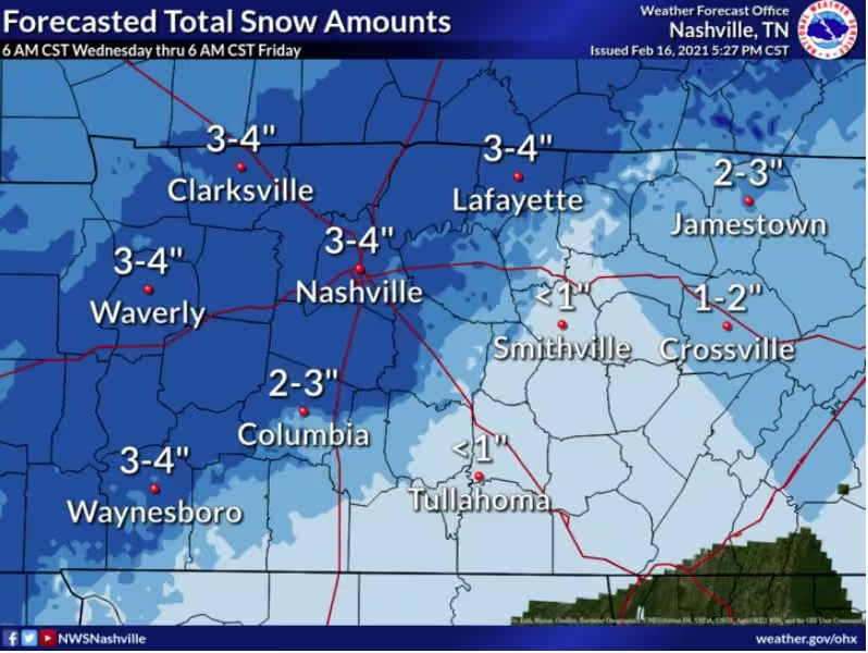
Here's the latest for tonight's snow event. Overall, the forecast remains on track. Showers will quickly transition to snow this evening with moderate and heavy snow continuing through the rest of the evening and after midnight. Snow will end from west to east after midnight.
-
Putnam County Emergency Management Agency
@PutnamEMATN
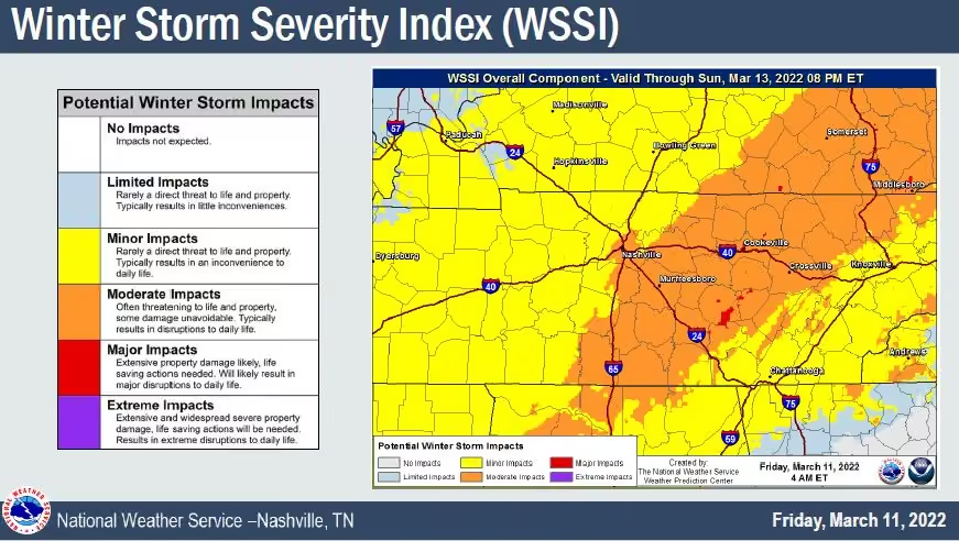
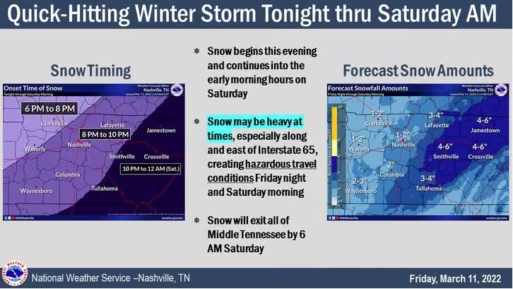
Rain changing over to snow in the 7-9pm timeframe tonight and continuing through around 3am. Bands of heavy snow are possible which may cause accumulation on roadways and walk paths. 4-6” accumulation possible.
A Winter Storm Warning is in effect through 8am Saturday. -
Putnam County Emergency Management Agency
@PutnamEMATN
Putnam County Alert:
Winter Storm Warning Winter Storm Warning issued March 11 at 2:35AM CST until March 12 at 8:00AM CST by NWS Nashville TN -
Putnam County Emergency Management Agency
@PutnamEMATN
Putnam County Alert:
Winter Storm Watch Winter Storm Watch issued March 10 at 1:51PM CST until March 12 at 9:00AM CST by NWS Nashville TN -
Putnam County Emergency Management Agency
@PutnamEMATN
A strong cold front will bring snow, frigid air, and gusty winds for Friday night. Slick travel will likely develop Friday night and continue into Saturday morning. The gusty winds and falling snow will create poor visibility at times.
-
Putnam County Emergency Management Agency
@PutnamEMATN
Rain changing over to snow Friday night will make way for possible snow accumulations, mainly on grassy surfaces but some travel impacts are possible.
We are predicted to receive 2-3 inches of accumulation, and with cold temps on Saturday night, any accumulation may hang around. -
Putnam County Emergency Management Agency
@PutnamEMATN
As strong to severe storms are still possible through the early afternoon hours, being prepared and weather aware is your best defense. Storms often escalate quickly, and with little or no warning. Stay #weatheraware and #readyputnam as we enter the main severe severe season.
-
Putnam County Emergency Management Agency
@PutnamEMATN
Putnam County Alert:
Wind Advisory Wind Advisory issued March 7 at 1:53AM CST until March 7 at 3:00PM CST by NWS Nashville TN -
Putnam County Emergency Management Agency
@PutnamEMATN
Strong to severe storms possible through Monday.
Storms may develop this evening, and some could be strong. A Marginal Risk (level 1 of 5) for severe storms Sunday afternoon/evening, and Slight Risk (level 2 of 5) for severe storms Monday has been issued by @NWSSPC -
Putnam County Emergency Management Agency
@PutnamEMATN
Today, we remember.
-
Putnam County Emergency Management Agency
@PutnamEMATN
ENDANGERED CHILD ALERT - Sumner County
Tennessee Bureau of Investigation
@TBInvestigation
ENDANGERED CHILD ALERT: We need your help to locate this missing one-year-old from Sumner County.
Kali Stafford is 29 inches tall, approximately 20 pounds, with brown hair and brown eyes. She was last seen yesterday wearing a white onesie.
Spot her? Call 1-800-TBI-FIND. -
Putnam County Emergency Management Agency
@PutnamEMATN
Yep, it’s really from us!
We are moving to @Smart911 for emergency alerts! Visit www.smart911.com to create an account.
Enter the data you want, leave out what you don’t want, and register for the alert lists you prefer.
Stay #readyputnam -
Putnam County Emergency Management Agency
@PutnamEMATN
Putnam County Alert:
Flood Advisory Flood Advisory issued February 24 at 8:05AM CST until February 24 at 11:15AM CST by NWS Nashville TN -
Putnam County Emergency Management Agency
@PutnamEMATN
Putnam County Alert:
Flood Watch Flood Watch issued February 23 at 1:41PM CST until February 25 at 6:00AM CST by NWS Nashville TN -
Putnam County Emergency Management Agency
@PutnamEMATN
IN OBSERVANCE OF SEVERE WEATHER AWARENESS WEEK
A Statewide Tornado Drill including a NOAA Weather Radio test will be conducted TODAY at 9:30 a.m. CST
PUTNAM EMA WILL ALSO BE TESTING THE OUTDOOR WARNING SIRENS AT 9:30 A.M. AS WELL.
www.weather.gov/ohx/swaw2022 -
Putnam County Emergency Management Agency
@PutnamEMATN
Putnam County Alert:
Flood Advisory Flood Advisory issued February 22 at 11:41AM CST until February 22 at 2:45PM CST by NWS Nashville TN -
Putnam County Emergency Management Agency
@PutnamEMATN
Strong to severe storms will be possible today and tonight. Main threats are straight line winds, tornadoes, and heavy rainfall.
-
Putnam County Emergency Management Agency
@PutnamEMATN
EMERGENCY ALERT UPDATE:
Effective March 1st, we will no longer utilize the NIXLE system for alerts (text messages come from 888-777). Visit www.smart911.com to sign up for the most updated emergency information. This will ensure faster alerts, without delays. -
Putnam County Emergency Management Agency
@PutnamEMATN
Putnam County Alert:
Flood Watch Flood Watch issued February 21 at 3:08AM CST until February 23 at 12:00PM CST by NWS Nashville TN -
Putnam County Emergency Management Agency
@PutnamEMATN
Severe Weather Awareness Week starts TODAY! Connect to @NWSNashville for tonight’s Basic Spotter Class and stay educated.
#swaw2022
NWS Nashville
@NWSNashville
Severe Weather Awareness Week starts today. We're kicking it off with a Basic Spotter Class tonight at 6:30 PM and following it up with a week full of live virtual presentations. Visit www.weather.gov/ohx/swaw2022 to sign up! #swaw2022 Which classes are you attending?
-
Putnam County Emergency Management Agency
@PutnamEMATN
Strong thunderstorms will impact portions of southeastern Overton, eastern Pickett, Cumberland, Van Buren, southeastern Warren, eastern White, southeastern Putnam and Fentress Counties through 645 PM CST [wind: 50 MPH, hail: 0.00 IN] mesonet.agron.iastate.edu/p.php?pid=2022…
IEMBot OHX
@iembot_ohx
Strong thunderstorms will impact portions of southeastern Overton, eastern Pickett, Cumberland, Van Buren, southeastern Warren, eastern White, southeastern Putnam and Fentress Counties through 645 PM CST [wind: 50 MPH, hail: 0.00 IN] mesonet.agron.iastate.edu/p.php?pid=202202180001-KOHX-WWU…
-
Putnam County Emergency Management Agency
@PutnamEMATN
Strong thunderstorms will impact portions of Overton, Pickett, southeastern Smith, north central De Kalb, Jackson, eastern Clay, northern Putnam and northwestern Fentress Counties through 615 PM CST [wind: 50 MPH, hail: 0.00 IN] mesonet.agron.iastate.edu/p.php?pid=2022…
IEMBot OHX
@iembot_ohx
Strong thunderstorms will impact portions of De Kalb, Van Buren, Warren, Coffee, northern Grundy, White, central Putnam and eastern Cannon Counties through 615 PM CST [wind: 55 MPH, hail: 0.00 IN] mesonet.agron.iastate.edu/p.php?pid=202202172334-KOHX-WWU…
-
Putnam County Emergency Management Agency
@PutnamEMATN
Strong thunderstorms will impact portions of Smith, Jackson, central Wilson, Clay, Macon, Trousdale and west central Putnam Counties through 530 PM CST [wind: 55 MPH, hail: 0.00 IN] mesonet.agron.iastate.edu/p.php?pid=2022…
IEMBot OHX
@iembot_ohx
Strong thunderstorms will impact portions of Smith, Jackson, central Wilson, Clay, Macon, Trousdale and west central Putnam Counties through 530 PM CST [wind: 55 MPH, hail: 0.00 IN] mesonet.agron.iastate.edu/p.php?pid=202202172251-KOHX-WWU…
-
Putnam County Emergency Management Agency
@PutnamEMATN
Severe storms possible tonight.
- 6-9pm timeframe
- Damaging winds and brief tornadoes expected
- Storms could produce ahead of main line
- 20-30mph winds with gusts up to 45mph possible today
Stay #weatheraware and have multiple ways to get alerts.
Visit @Readygov to prepare -
Putnam County Emergency Management Agency
@PutnamEMATN
Slight Risk severe storms Thursday evening. Wind gusts 40-50mph possible at times Thursday. If storms develop, expect heavy downpours, damaging winds, and brief tornadoes.
A Wind Advisory is in effect through 9pm Thursday. Stay #weatheraware and have multiple ways to get alerts. -
Putnam County Emergency Management Agency
@PutnamEMATN
Putnam County Alert:
Wind Advisory Wind Advisory issued February 16 at 3:01AM CST until February 17 at 9:00PM CST by NWS Nashville TN -
Putnam County Emergency Management Agency
@PutnamEMATN
Precipitation is expected to end completely by noon, but temperatures will remain near or below freezing for much of the day. Some roads and overpasses may remain slick as a result, so motorists are advised to use caution while traveling.
-
Putnam County Emergency Management Agency
@PutnamEMATN
Putnam County Alert:
Winter Weather Advisory Winter Weather Advisory issued February 4 at 6:05AM CST until February 4 at 8:00AM CST by NWS Nashville TN -
Putnam County Emergency Management Agency
@PutnamEMATN
LOCAL CONDITIONS: Temps dropping and icing noted on trees and elevated surfaces. As temps continue dropping, expect icing on bridges and overpasses. Nashville area reporting icing on main roads, which could be expected locally soon. Allow extra time for morning travel. #staysafe
-
Putnam County Emergency Management Agency
@PutnamEMATN
Putnam County Alert:
Flood Advisory Flood Advisory issued February 3 at 4:20PM CST until February 3 at 7:00PM CST by NWS Nashville TN -
Putnam County Emergency Management Agency
@PutnamEMATN
Putnam County Alert:
Flood Advisory Flood Advisory issued February 3 at 4:17PM CST until February 3 at 7:00PM CST by NWS Nashville TN -
Putnam County Emergency Management Agency
@PutnamEMATN
Ice accumulations will be the highest north and west of Nashville, though hazardous travel impacts will be similar across the Winter Weather Advisory area thru Friday morning. A WINTER WEATHER ADVISORY IS IN EFFECT FROM 8 p.m. until 4 a.m. Friday.
-
Putnam County Emergency Management Agency
@PutnamEMATN
Flash Flood Watch today - Winter Weather Advisory tonight.
Potential for flash flooding today, changing over to freezing rain late tonight. Up to 0.10” ice accumulation possible overnight.
Stay weather aware - Turn Around, Don’t Drown! -
Putnam County Emergency Management Agency
@PutnamEMATN
FLOOD WATCH - Wednesday and Thursday.
Significant (heavy at times) rain leads to increased flood risk Wednesday and especially Thursday.
Slow down and allow extra travel time.
If roadway flooded, #turnarounddontdrown -
Putnam County Emergency Management Agency
@PutnamEMATN
Putnam County Alert:
Flood Watch Flood Watch issued February 2 at 1:50AM CST until February 4 at 12:00AM CST by NWS Nashville TN -
Putnam County Emergency Management Agency
@PutnamEMATN
Official accumulation reports range from 0.5” in West Putnam County, up to 2” in East Putnam.
Sunshine has begun melting, but shaded areas may remain slick with a high of 30 today.
Remain vigilant as you travel today. The next weather system will impact our area mid week. -
Putnam County Emergency Management Agency
@PutnamEMATN
Putnam County Alert:
Winter Weather Advisory Winter Weather Advisory issued January 28 at 10:33AM CST until January 29 at 3:00AM CST by NWS Nashville TN -
Putnam County Emergency Management Agency
@PutnamEMATN
Tonight's total snow and sleet accumulations are expected to range from less than an inch northern Highland Rim to no significant accumulations near Tennessee/Alabama Border.
-
Putnam County Emergency Management Agency
@PutnamEMATN
5:10am UPDATE: All lanes of westbound traffic are now open and traffic flowing at highway speeds.
-
Putnam County Emergency Management Agency
@PutnamEMATN
10:35pm I-40 270 mm Westbound UPDATE: Crews have worked to reopen one lane of westbound traffic. Traffic is expected to be down to one lane for a few hours.
-
Putnam County Emergency Management Agency
@PutnamEMATN
I-40 CLOSED - Mile marker 270 Westbound due to crash. This is near the Buffalo Valley exit (268).
A tractor-trailer has rolled over and cleanup is expected to take hours. I-40 is expected to remain closed past midnight. -
Putnam County Emergency Management Agency
@PutnamEMATN
Putnam County Alert:
Freezing Fog Advisory Freezing Fog Advisory issued January 18 at 4:29AM CST until January 18 at 9:00AM CST by NWS Nashville TN -
Putnam County Emergency Management Agency
@PutnamEMATN
Putnam County Alert:
Winter Weather Advisory Winter Weather Advisory issued January 17 at 1:02AM CST until January 17 at 6:00PM CST by NWS Nashville TN -
Putnam County Emergency Management Agency
@PutnamEMATN
Putnam County Alert:
Winter Storm Warning Winter Storm Warning issued January 15 at 2:15PM CST until January 17 at 12:00AM CST by NWS Nashville TN -
Putnam County Emergency Management Agency reposted
Tennessee Bureau of Investigation
@TBInvestigation
UPDATE: We're pleased to report Alijah Kensinger has been found safe in the woods near his home in Monroe County.
He's a little cold, but otherwise in good spirits! 👍
Thank you for your retweets, prayers, and support!
#tnamberalert -
Putnam County Emergency Management Agency
@PutnamEMATN
WINTER STORM WATCH Snowfall forecast for Saturday night and Sunday shows most of Middle Tennessee in the 3 to 6 inch range. Local higher totals are possible where heavy bands of snow develop. You can expect these totals to be adjusted through the next 24 hours.
-
Putnam County Emergency Management Agency
@PutnamEMATN
Putnam County Alert:
Winter Storm Watch Winter Storm Watch issued January 14 at 2:47AM CST until January 16 at 6:00PM CST by NWS Nashville TN -
Putnam County Emergency Management Agency
@PutnamEMATN
*Heavy Rainfall and Flooding Possible Sunday into Sunday Night*
Much of Middle Tennessee should receive at least 1 to 2
inches of rain with the potential for locally heavier amounts up to 2 and a half inches. This rainfall in addition to the melting snow could cause flooding. -
Putnam County Emergency Management Agency
@PutnamEMATN
SPECIAL WEATHER STATEMENT.
By @NWSNashville -
Putnam County Emergency Management Agency
@PutnamEMATN
Expected snowfall amounts today and this evening.
-
Putnam County Emergency Management Agency
@PutnamEMATN
Putnam County Alert:
Winter Storm Warning Winter Storm Warning issued January 5 at 9:05PM CST until January 6 at 9:00PM CST by NWS Nashville TN -
Putnam County Emergency Management Agency
@PutnamEMATN
Tune in to @WKRN to see Director @btnsmith provide an update on Winter weather preparations and Winter weather safety tips.
Stay tuned to this account and @NWSNashville for updates as they become available. -
Putnam County Emergency Management Agency
@PutnamEMATN
Putnam County Alert:
Winter Weather Advisory Winter Weather Advisory issued January 5 at 10:53AM CST until January 6 at 9:00PM CST by NWS Nashville TN -
Putnam County Emergency Management Agency
@PutnamEMATN
...Snow and Hazardous Travel Conditions Expected Thursday...
Another blast of winter weather is expected throughout Middle Tennessee on Thursday, with wintry precipitation spreading across the area Thursday morning before ending during the afternoon and
early evening. -
Putnam County Emergency Management Agency
@PutnamEMATN
...SIGNIFICANT SNOWFALL LIKELY THURSDAY INTO THURSDAY EVENING...
A STORM SYSTEM MOVING OVER THE REGION WILL BRING SNOW TO THE MID-STATE ONCE AGAIN THURSDAY AND THURSDAY EVENING.
AMOUNTS RANGE FROM AROUND ONE HALF INCH SOUTHWEST TO AS MUCH A 4 INCHES ALONG THE UPPER CUMBERLAND. -
Putnam County Emergency Management Agency
@PutnamEMATN
Putnam County Alert:
Winter Storm Warning Winter Storm Warning issued January 3 at 2:06AM CST until January 3 at 7:00AM CST by NWS Nashville TN -
Putnam County Emergency Management Agency reposted
NWS Nashville
@NWSNashville
Since this is our first snowfall threat of the season, remember to slow down and leave plenty of space between you and other vehicles later today. Roads are warm now, but some slick spots are likely to develop later tonight as temperatures fall below freezing.
-
Putnam County Emergency Management Agency
@PutnamEMATN
Accumulating snow possible Sunday and Sunday night.
Please stay connected to our partners @NWSNashville for the latest updates as this forecast has changed significantly.
NWS Nashville
@NWSNashville
Snowfall amounts could be a bit higher than we were thinking earlier today. Roads are still warm from the 70+ degrees we saw yesterday (was that really yesterday?), so we'll see these totals more on grassy or elevated surfaces. Watch for slick roads later tonight as it freezes.
-
Putnam County Emergency Management Agency
@PutnamEMATN
Putnam County Alert:
Winter Weather Advisory Winter Weather Advisory issued January 2 at 3:09AM CST until January 3 at 3:00AM CST by NWS Nashville TN -
Putnam County Emergency Management Agency
@PutnamEMATN
3:30pm UPDATE:
Severe storm and tornado potential continues to decrease for our area. Current conditions are still favorable for storm development, but the threat of tornadoes and severe storms has decreased.
Stay #weatheraware as storms can still develop.
Radar: @Windycom -
Putnam County Emergency Management Agency
@PutnamEMATN
Putnam County Alert:
Tornado Watch Tornado Watch issued January 1 at 1:00PM CST until January 1 at 7:00PM CST by NWS Nashville TN -
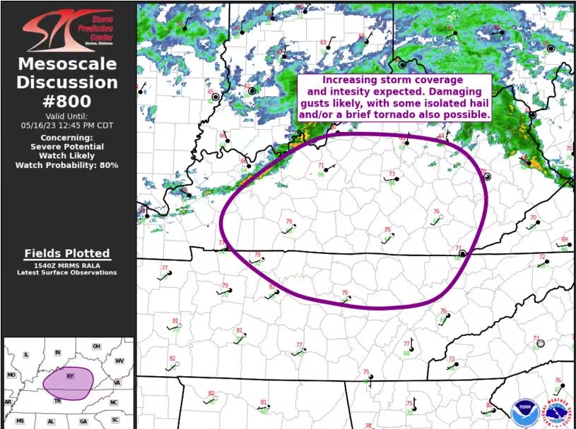
Putnam County Emergency Management Agency
@PutnamEMATN
Putnam County Alert:
Wind Advisory Wind Advisory issued January 1 at 10:27AM CST until January 1 at 9:00PM CST by NWS Nashville TN -
Putnam County Emergency Management Agency
@PutnamEMATN
Windy New Years Day and evening storm threat.
The threat with these storms will be damaging winds, large hail, heavy rainfall (potentially leading to flooding), and a few tornadoes are possible.
Level 3 of 5 risk for severe storms, 4-9pm this evening.
Please stay #weatheraware -
Putnam County Emergency Management Agency
@PutnamEMATN
With a risk of severe weather overnight tonight, and the afternoon/evening tomorrow, take a moment to review your plan:
* Have multiple systems to receive alerts
* Know where you’ll go if a warning occurs
* Flooded roads: Turn Around, Don’t Drown
* Stay connected for updates -
Putnam County Emergency Management Agency
@PutnamEMATN
-
Putnam County Emergency Management Agency
@PutnamEMATN
The NOAA NWS Storm Prediction Center has issued an ENHANCED RISK for severe storm development on Saturday afternoon and evening for our area. We remain under a marginal risk (level 1 of 5) for severe storms overnight Friday night.
Enhanced is a level 3/5 risk.
Stay #weatheraware -
Putnam County Emergency Management Agency
@PutnamEMATN
Putnam County Alert:
Dense Fog Advisory Dense Fog Advisory issued December 30 at 7:50PM CST until December 31 at 7:00AM CST by NWS Nashville TN -
Putnam County Emergency Management Agency
@PutnamEMATN
Severe weather is possible again Friday night and Saturday. Many details still need to be worked out, but please remain weather aware if you have New Year's Eve plans.
-
Putnam County Emergency Management Agency
@PutnamEMATN
Putnam County Alert:
Dense Fog Advisory Dense Fog Advisory issued December 30 at 6:21AM CST until December 30 at 9:00AM CST by NWS Nashville TN -
Putnam County Emergency Management Agency
@PutnamEMATN
The @NWSSPC has decreased the risk of severe storms for our area the rest of tonight. Strong wind gusts and heavy rain may still cause issues, and a tornado cannot be ruled out, but the risk has decreased to the marginal risk category. Most storms are remaining to the South.
-
Putnam County Emergency Management Agency
@PutnamEMATN
Strong to severe storms will be possible this afternoon and evening. Damaging straight line winds are the main concern, but a tornado cannot be ruled out. Look for 1 to 2 inches of rainfall, Also.
-
Putnam County Emergency Management Agency
@PutnamEMATN
There is a slight risk of strong to severe storms Wednesday afternoon and evening. Storms are primarily expected South of Interstate 40, but periods of heavy rainfall are anticipated throughout the area.
Stay #weatheraware and connected to receive updates from @NWSNashville -
Putnam County Emergency Management Agency
@PutnamEMATN
Putnam County Alert:
Dense Fog Advisory Dense Fog Advisory issued December 26 at 5:17AM CST until December 26 at 9:00AM CST by NWS Nashville TN -
Putnam County Emergency Management Agency
@PutnamEMATN
Putnam County Alert:
Severe Thunderstorm Warning Severe Thunderstorm Warning issued December 11 at 5:21AM CST until December 11 at 6:00AM CST by NWS Nashville TN -
Putnam County Emergency Management Agency
@PutnamEMATN
Putnam County Alert:
Severe Thunderstorm Warning Severe Thunderstorm Warning issued December 11 at 4:11AM CST until December 11 at 4:45AM CST by NWS Nashville TN -
Putnam County Emergency Management Agency
@PutnamEMATN
Putnam County Alert:
Severe Thunderstorm Warning Severe Thunderstorm Warning issued December 11 at 3:50AM CST until December 11 at 4:30AM CST by NWS Nashville TN -
Putnam County Emergency Management Agency
@PutnamEMATN
Putnam County Alert:
Tornado Watch Tornado Watch issued December 11 at 3:44AM CST until December 11 at 11:00AM CST by NWS Nashville TN -
Putnam County Emergency Management Agency
@PutnamEMATN
Preparing for the storm threat overnight? So are we. We are monitoring the system until the threat passes. Be sure to visit www.putnamcountytn.gov/911-center to sign up for emergency alerts, and www.ready.gov to double check your plan.
-
Putnam County Emergency Management Agency
@PutnamEMATN
Putnam County Alert:
Wind Advisory Wind Advisory issued December 10 at 11:22AM CST until December 11 at 12:00PM CST by NWS Nashville TN -
Putnam County Emergency Management Agency
@PutnamEMATN
The US National Weather Service Nashville Tennessee office has confirmed the Cookeville NOAA Weather Radio transmitter is online and operating.
Always remember to have multiple ways to receive alerts. -
Putnam County Emergency Management Agency
@PutnamEMATN
Severe thunderstorms are possible tonight and into Saturday morning across Middle Tennessee as a strong cold front sweeps across the area. The primary threats are going to be damaging straight-line winds and a few tornadoes. Isolated large hail is also possible.
-
Putnam County Emergency Management Agency
@PutnamEMATN
Severe thunderstorms are possible Friday night and into Saturday morning across Middle Tennessee as a strong cold front sweeps across the area. The primary threats are going to be damaging straight-line winds and isolated tornadoes. Isolated large hail is also possible.
-
Putnam County Emergency Management Agency
@PutnamEMATN
Severe thunderstorms are possible Friday night and into Saturday morning across Middle Tennessee as a strong cold front sweeps across the area. At this time, it appears that the primary threats with any severe storms are damaging straight-line winds and isolated tornadoes.
-
Putnam County Emergency Management Agency
@PutnamEMATN
Putnam County Alert:
Severe Thunderstorm Warning Severe Thunderstorm Warning issued December 6 at 7:11AM CST until December 6 at 8:00AM CST by NWS Nashville TN -
Putnam County Emergency Management Agency
@PutnamEMATN
Putnam County Alert:
Severe Thunderstorm Warning Severe Thunderstorm Warning issued December 6 at 6:38AM CST until December 6 at 7:15AM CST by NWS Nashville TN -
Putnam County Emergency Management Agency
@PutnamEMATN
The Cookeville NOAA weather radio transmitter (located in East Putnam County, 162.400) has gone offline. Most radios in our area actually use the Hickman site (162.500).
This reinforces having multiple ways to receive alerts. Please stay weather aware throughout the morning. -
Putnam County Emergency Management Agency
@PutnamEMATN
A fast-moving line of storms is moving into the Nashville area. Some storms are producing damaging wind gusts, with heavy downpours. Wind gusts ahead of the line are measuring up to 50mph.
Stay weather aware and plan accordingly this morning.
Image via windy.com -
Putnam County Emergency Management Agency
@PutnamEMATN
Storms have begun to develop across Tennessee. Some storms have reached severe parameters at times, Storms may continue to develop overnight. A line of storms is predicted around 8am Monday, with downpours and gusty winds.
Radar Image via windy.com -
Putnam County Emergency Management Agency
@PutnamEMATN
Strong to severe thunderstorms are possible in two waves: this afternoon and early evening, followed by a line of storms after midnight Monday morning. Damaging wind is the primary concern, though conditions may become favorable for tornadoes...especially along and west of I-65.
-
Putnam County Emergency Management Agency
@PutnamEMATN
The @NWSSPC has issued a MARGINAL RISK for severe storms late Sunday night and into the overnight hours.
Damaging winds and a tornado cannot be ruled out, highest threat West of I-65.
Stay #weatheraware and have multiple ways to receive alerts. -
Putnam County Emergency Management Agency
@PutnamEMATN
AMBER ALERT - Gallatin, TN
Tennessee Bureau of Investigation
@TBInvestigation
#tnamberalert: Noah is 3 years old, with brown hair and blue eyes. He stands approximately 3'5" and weighs approximately 40 pounds.
He may be with Jacob "Jake" Clare. The 35-year-old stands 6'7" and weighs approximately 200 pounds.
2/4 -
Putnam County Emergency Management Agency
@PutnamEMATN
I-40 at 290 mile marker eastbound is
shut down due to accident.
smartway.tn.gov/traffic?features=incident,traffic&positio… -
Putnam County Emergency Management Agency
@PutnamEMATN
Putnam County Alert:
Dense Fog Advisory Dense Fog Advisory issued November 12 at 12:15AM CST until November 12 at 8:00AM CST by NWS Nashville TN -
Putnam County Emergency Management Agency
@PutnamEMATN
Putnam County Alert:
Freeze Warning Freeze Warning issued November 3 at 1:50PM CDT until November 5 at 9:00AM CDT by NWS Nashville TN -
Putnam County Emergency Management Agency
@PutnamEMATN
Putnam County Alert:
Freeze Warning Freeze Warning issued November 3 at 2:35AM CDT until November 4 at 9:00AM CDT by NWS Nashville TN -
Putnam County Emergency Management Agency
@PutnamEMATN
Putnam County Alert:
Freeze Watch Freeze Watch issued November 2 at 2:18PM CDT until November 4 at 9:00AM CDT by NWS Nashville TN -
Putnam County Emergency Management Agency
@PutnamEMATN
Putnam County Alert:
Frost Advisory Frost Advisory issued November 2 at 2:53AM CDT until November 3 at 9:00AM CDT by NWS Nashville TN -
Putnam County Emergency Management Agency reposted
NWS Nashville
@NWSNashville
A weakening line of showers and thunderstorms is moving eastward into northwest #middletennessee early this morning. Wind gusts over 40 mph are possible with the line, which could knock down tree limbs and blow around outdoor objects #tnwx
-
Putnam County Emergency Management Agency reposted
NWS Nashville
@NWSNashville
Gusty south winds continue across #middletennessee this morning ahead of the line of rain and storms - #nashville Int'l Airport recently measured a wind gust of 36 mph #tnwx
-
Putnam County Emergency Management Agency
@PutnamEMATN
Strong to severe storms possible Sunday-Monday. Sustained gusty winds will be the norm today and overnight into tomorrow morning, with some strong to severe storms developing ahead of the cold front. Extreme East Putnam is in MARGINAL RISK for severe storms Monday.
-
Putnam County Emergency Management Agency
@PutnamEMATN
Chance for strong/severe storms Thursday afternoon. While widespread severe weather is not expected, as the cold front moves through this afternoon and evening, gusty winds, small hail, and a tornado or two cannot be ruled out as these storms move across the Cumberland Plateau.
-
Putnam County Emergency Management Agency
@PutnamEMATN
The @NWSSPC issued a MARGINAL RISK for severe storms Thursday afternoon and evening in our area. While not a widespread event, some storm that develop could have gusty winds and brief downpours. Stay weather aware and have multiple systems to get alerts.
-
Putnam County Emergency Management Agency
@PutnamEMATN
Putnam County Alert:
Severe Thunderstorm Watch Severe Thunderstorm Watch issued October 15 at 6:05PM CDT until October 16 at 12:00AM CDT by NWS Nashville TN -
Putnam County Emergency Management Agency
@PutnamEMATN
Chances for strong to severe thunderstorms will be in place this afternoon through the evening. Main threat will be damaging wind gusts with any strong to severe storms, but an isolated tornado or two along with localized flooding cannot be ruled out.
-
Putnam County Emergency Management Agency
@PutnamEMATN
Chances for strong to severe thunderstorms will be in place Friday afternoon through the mid evening. Main threat will be damaging wind gusts with any strong to severe storms, but an isolated tornado or two along with localized flooding can not be ruled out.
-
Putnam County Emergency Management Agency
@PutnamEMATN
Putnam County Alert:
Dense Fog Advisory Dense Fog Advisory issued October 8 at 1:35AM CDT until October 8 at 9:00AM CDT by NWS Nashville TN -
Putnam County Emergency Management Agency
@PutnamEMATN
Putnam County Alert:
Flood Advisory Flood Advisory issued October 7 at 12:24AM CDT until October 7 at 2:30AM CDT by NWS Nashville TN -
Putnam County Emergency Management Agency
@PutnamEMATN
Putnam County Alert:
Flash Flood Warning Flash Flood Warning issued October 6 at 8:52PM CDT until October 7 at 12:00AM CDT by NWS Nashville TN -
Putnam County Emergency Management Agency
@PutnamEMATN
Putnam County Alert:
Flood Advisory Flood Advisory issued October 6 at 7:16PM CDT until October 6 at 10:30PM CDT by NWS Nashville TN -
Putnam County Emergency Management Agency
@PutnamEMATN
TORNADO WATCH: Putnam County is under a Tornado Watch until 10:00pm. A Tornado Watch means conditions are favorable for tornado development. Ensure you have multiple ways to receive alerts and stay weather aware as storms may continue developing throughout the evening hours.
-
Putnam County Emergency Management Agency
@PutnamEMATN
A strong thunderstorm capable of producing a tornado is moving north out of Pikeville (Bledsoe County). This storm currently has a Tornado Warning associated with it.
On its current track will move through the far Eastern area of Putnam County and may include Monterey. -
Putnam County Emergency Management Agency
@PutnamEMATN
Putnam County Alert:
Flood Advisory Flood Advisory issued October 6 at 2:49PM CDT until October 6 at 6:45PM CDT by NWS Nashville TN -
Putnam County Emergency Management Agency
@PutnamEMATN
Putnam County Alert:
Severe Thunderstorm Warning Severe Thunderstorm Warning issued October 6 at 11:59AM CDT until October 6 at 12:45PM CDT by NWS Nashville TN -
Putnam County Emergency Management Agency
@PutnamEMATN
Isolated strong to severe thunderstorms will be possible this afternoon and evening across most of Middle Tennessee. With any strong to severe thunderstorms that do develop, main threats will be strong to damaging winds and potentially large hail.
-
Putnam County Emergency Management Agency
@PutnamEMATN
Moderate and occasionally heavy rainfall is occurring throughout Putnam County.
As heavy rain and thunderstorms continue to develop and train across our area, minor flooding may occur.
Never cross flooded roads/walk paths. Turn around, don’t drown!
Radar: @weatherTAP -
Putnam County Emergency Management Agency
@PutnamEMATN
Putnam County Alert:
Flood Advisory Flood Advisory issued October 3 at 1:05PM CDT until October 3 at 5:00PM CDT by NWS Nashville TN -
Putnam County Emergency Management Agency
@PutnamEMATN
A test of the Outdoor Warning Sirens will be conducted at 10:00 a.m. today.
-
Putnam County Emergency Management Agency
@PutnamEMATN
FLASH FLOOD THREAT
9-20-21
What: Flash Flood Watch in effect for all of Middle Tennessee through 7pm this evening.
When: Monday morning/afternoon
Where: Southeastern Middle Tennessee has the highest potential for flash flooding today, but flooding is possible anywhere. -
Putnam County Emergency Management Agency
@PutnamEMATN
Flooding has been reported in Putnam County. Dodson Branch @ Kinniard Rd. Also County Farm Rd. Gainesboro Grade and Benton Young Rd. A Flood Advisory has been issued for Putnam County until 2:30 p.m. DO NOT CROSS FLOODED ROADS.."TURN AROUND DONT DROWN"
-
Putnam County Emergency Management Agency
@PutnamEMATN
Putnam County Alert:
Flood Advisory Flood Advisory issued September 18 at 11:21AM CDT until September 18 at 2:30PM CDT by NWS Nashville TN -
Putnam County Emergency Management Agency
@PutnamEMATN
Putnam County Alert:
Flood Advisory Flood Advisory issued September 15 at 2:57PM CDT until September 15 at 5:00PM CDT by NWS Nashville TN -
Putnam County Emergency Management Agency
@PutnamEMATN
Putnam County Alert:
Flood Advisory Flood Advisory issued September 15 at 2:20PM CDT until September 15 at 5:30PM CDT by NWS Nashville TN -
Putnam County Emergency Management Agency
@PutnamEMATN
What: 1-2 inches of rain with the potential for 3 to 4 inches in a few spots. This could lead to flash flooding.
When: This morning, into the early afternoon hours.
Where: Focus is along and north of I-40, possibly closer to the KY state line, or anywhere west of the Plateau. -
Putnam County Emergency Management Agency
@PutnamEMATN
Putnam EMA Mourns Loss of Longtime Member Marty Smith herald-citizen.com/stories/putnam-ema-mourns-loss-of-long…
-
Putnam County Emergency Management Agency
@PutnamEMATN
Additional 2-4” rain possible today from #ida. No significant flooding reported in Putnam Co. Strong/severe storms possible today, and isolated tornado cannot be ruled out.
Stay #weatheraware as heavy downpours and storm development are possible today. -
Putnam County Emergency Management Agency
@PutnamEMATN
Putnam County Alert:
Flood Advisory Flood Advisory issued August 30 at 6:20PM CDT until August 30 at 8:00PM CDT by NWS Nashville TN -
Putnam County Emergency Management Agency
@PutnamEMATN
Putnam County Alert:
Flood Advisory Flood Advisory issued August 30 at 5:49PM CDT until August 30 at 7:00PM CDT by NWS Nashville TN -
Putnam County Emergency Management Agency
@PutnamEMATN
Hurricane Ida has made landfall and will continue to move farther inland. The tropical system will soon turn northeastward and weaken to a Tropical Depression. Middle Tennessee can expect anywhere from 2 to 5 inches of rainfall from this system.
-
Putnam County Emergency Management Agency
@PutnamEMATN
Ida impacts for Middle Tennessee:
- Strong to severe storms possible Monday night into Tuesday.
- Isolated tornadoes cannot be ruled out.
- Tuesday, we are under a Moderate Risk for excessive rainfall (3-4” expected)
- Flash Flood Watch in effect Monday 7pm - Wednesday 1am. -
Putnam County Emergency Management Agency
@PutnamEMATN
Latest information from @NWSNashville on Ida’s potential impacts.
NWS Nashville
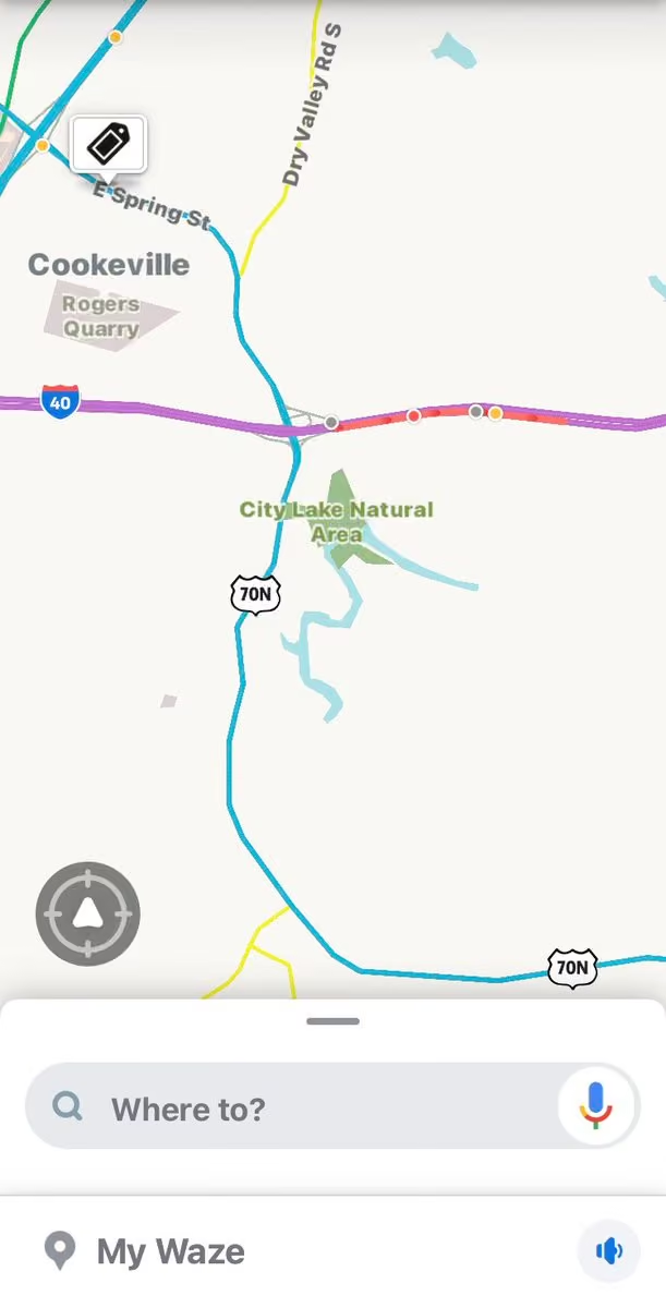
@NWSNashville
Latest on Ida 👇
-
Putnam County Emergency Management Agency
@PutnamEMATN
Stay connected with us and @NWSNashville for expected impacts of Hurricane Ida.
NWS Nashville
@NWSNashville
Thread on all things Ida and what to expect here in Middle TN.
Ida is expected to make landfall later today along the Louisiana coastline. As Ida moves onshore, it will make a sharp turn to the northeast, bring heavy showers and t'storms our way. -
Putnam County Emergency Management Agency
@PutnamEMATN
Putnam County Alert:
Flood Advisory Flood Advisory issued August 28 at 2:26PM CDT until August 28 at 4:30PM CDT by NWS Nashville TN -
Putnam County Emergency Management Agency
@PutnamEMATN
A test of the Outdoor Warning Sirens will be conducted at 10:00 a.m. today.
-
Putnam County Emergency Management Agency
@PutnamEMATN
If you have friends/family in Dickson, Houston, Hickman, or Humphreys counties, check on them. They are under a Flash Flood Emergency and emergency managers are reporting flooding and damage, with more heavy rain still falling and expected to last for a few hours.
-
Putnam County Emergency Management Agency
@PutnamEMATN
Putnam County Alert:
Flood Advisory Flood Advisory issued August 18 at 4:43PM CDT until August 18 at 6:45PM CDT by NWS Nashville TN -
Putnam County Emergency Management Agency
@PutnamEMATN
Putnam County Alert:
Flood Advisory Flood Advisory issued August 15 at 3:20PM CDT until August 15 at 6:30PM CDT by NWS Nashville TN -
Putnam County Emergency Management Agency
@PutnamEMATN
NOAA NWS Storm Prediction Center has issued a MARGINAL RISK for severe storm development Friday.
The primary threat is damaging winds, hail, and occasional heavy downpours. Tornadoes are not expected.
Stay weather aware on Friday and have multiple systems for receiving alerts. -
Putnam County Emergency Management Agency
@PutnamEMATN
NATIONAL EMERGENCY ALERT TEST TODAY
Wednesday Aug 11th
Your phone may alert (with sound and vibration), despite being in silent mode.
Also check your Notifications settings to ensure Emergency Alerts are turned on. This will ensure you receive local emergency alerts as well. -
Putnam County Emergency Management Agency
@PutnamEMATN
Congratulations to EMA Director @btnsmith on being presented the Bill Worth Award, at the Statewide emergency manager’s conference today in Franklin. This award is given by EMAT and TEMA IN recognition of excellence in senior leadership, following the 2020 tornado.
-
Putnam County Emergency Management Agency
@PutnamEMATN
NATIONAL EMERGENCY ALERT TEST
Wednesday August 11th
Your phone may alert (with sound and vibration), despite being in silent mode.
Be sure to check your Notifications settings to ensure Emergency Alerts are turned on. This will ensure you receive local emergency alerts also. -
Putnam County Emergency Management Agency
@PutnamEMATN
Putnam County Alert:
Severe Thunderstorm Warning Severe Thunderstorm Warning issued August 9 at 5:44PM CDT until August 9 at 6:15PM CDT by NWS Nashville TN -
Putnam County Emergency Management Agency
@PutnamEMATN
Some strong to severe thunderstorms may be possible late Saturday afternoon through the early morning hours Sunday. Main concerns with any strong thunderstorm development will be gusty strong winds as well as heavy rainfall which could lead to localized flooding.
-
Putnam County Emergency Management Agency
@PutnamEMATN
Putnam County Alert:
Severe Thunderstorm Warning Severe Thunderstorm Warning issued July 30 at 5:08AM CDT until July 30 at 5:45AM CDT by NWS Nashville TN -
Putnam County Emergency Management Agency
@PutnamEMATN
Putnam County Alert:
Dense Fog Advisory Dense Fog Advisory issued July 29 at 3:23AM CDT until July 29 at 8:00AM CDT by NWS Nashville TN -
Putnam County Emergency Management Agency
@PutnamEMATN
Putnam County Alert:
Dense Fog Advisory Dense Fog Advisory issued July 28 at 2:47AM CDT until July 28 at 8:00AM CDT by NWS Nashville TN -
Putnam County Emergency Management Agency
@PutnamEMATN
Putnam County Alert:
Flood Advisory Flood Advisory issued July 18 at 8:30PM CDT until July 18 at 10:30PM CDT by NWS Nashville TN -
Putnam County Emergency Management Agency
@PutnamEMATN
The @NWSSPC has issued a Marginal Excessive Rainfall Outlook through Monday. This means any showers and storms that develop may produce brief heavy rainfall. The potential for showers/storms to produce long periods of heavy rain exists but the risk is low.
-
Putnam County Emergency Management Agency
@PutnamEMATN
MARGINAL RISK for strong storms remains through Monday. Damaging winds and heavy downpours are the main threat. Widespread storms are not expected and severe storm threat is low, but does exist. Stay weather aware as the afternoon storm trend may continue through Tuesday.
-
Putnam County Emergency Management Agency
@PutnamEMATN
MARGINAL RISK for strong storms Sunday. Damaging winds and heavy downpours are the main threat with storms that may develop this afternoon and evening. This pattern continues for the next couple days, where pop up thunderstorms are possible.
-
Putnam County Emergency Management Agency
@PutnamEMATN
Instability still exists in our area for storms and will remain into the overnight and morning hours. Several storms North and West of us have reached severe levels this evening.
NOAA NWS Storm Prediction Center has issued a MARGINAL RISK for severe storms on Sunday as well. -
Putnam County Emergency Management Agency
@PutnamEMATN
The @NWSSPC has issued a MARGINAL RISK for severe storms this afternoon and evening. Damaging wind and large hail are the main threat, and a tornado cannot be ruled out. Storms should weaken in the late evening hours. Stay weather aware & #readyputnam as storms may develop quick.
-
Putnam County Emergency Management Agency
@PutnamEMATN
As Elsa continues to make its way up the East Coast, it sets up a pattern for scattered showers and thunderstorms here today and tomorrow.
Some storms could have a few gusty winds in them, and possibly continuing into the overnight hours.
Photo: @weatherTAP -
Putnam County Emergency Management Agency
@PutnamEMATN
As we celebrate our independence, and we can’t do that without thanking the men and women of our fighting forces, we sincerely hope your family has a safe celebration.
As many travel our nations highways to celebrate, please drive safely and buckle up! -
Putnam County Emergency Management Agency
@PutnamEMATN
Each day in the U.S. (this time of year) an average of 230 people will visit local emergency rooms with fireworks-related injuries. Please take extra care with fireworks this July 4th holiday.
Happy Independence Day, America!!! -
Putnam County Emergency Management Agency
@PutnamEMATN
Showers and thunderstorms will move in this morning with increasing coverage by this afternoon & evening. Some strong storms are possible. Gusty winds and heavy rain will be the main threats. Minor flooding possible for areas with multiple rounds of heavy rain today thru Friday.
-
Putnam County Emergency Management Agency
@PutnamEMATN
SIGNIFICANT WEATHER ADVISORY FOR NORTHEASTERN DE KALB, NORTHWESTERN WHITE AND SOUTHWESTERN PUTNAM COUNTIES UNTIL 615 PM CDT mesonet.agron.iastate.edu/p.php?pid=2021…
-
Putnam County Emergency Management Agency
@PutnamEMATN
SIGNIFICANT WEATHER ADVISORY FOR EAST CENTRAL DE KALB, NORTHWESTERN WHITE AND SOUTHWESTERN PUTNAM COUNTIES UNTIL 200 PM CDT mesonet.agron.iastate.edu/p.php?pid=2021…
-
Putnam County Emergency Management Agency
@PutnamEMATN
A test of the Outdoor Warning Sirens will be conducted at 10:00 a.m. today.
-
Putnam County Emergency Management Agency
@PutnamEMATN
As nighttime sets in, @NWSNashville is expecting to begin decreasing severe storm potential. Storms may still develop, but the later into the evening we go, the less the chances of severe storms. Multiple reports of damage in neighboring counties today - none in Putnam Co.
-
Putnam County Emergency Management Agency
@PutnamEMATN
Putnam County Alert:
Severe Thunderstorm Warning Severe Thunderstorm Warning issued June 21 at 2:38PM CDT until June 21 at 3:15PM CDT by NWS Nashville TN -
Putnam County Emergency Management Agency
@PutnamEMATN
Putnam County Alert:
Severe Thunderstorm Watch issued June 21 at 12:52PM CDT until June 21 at 8:00PM CDT by NWS Nashville TN
THE NATIONAL WEATHER SERVICE HAS ISSUED SEVERE THUNDERSTORM WATCH
301 IN EFFECT UNTIL 8 PM CDT THIS EVENING FOR PUTNAM COUNTY. -
Putnam County Emergency Management Agency
@PutnamEMATN
Putnam County Alert:
Severe Thunderstorm Watch Severe Thunderstorm Watch issued June 21 at 12:52PM CDT until June 21 at 8:00PM CDT by NWS Nashville TN -
Putnam County Emergency Management Agency
@PutnamEMATN
The NOAA NWS Storm Prediction Center has issued a SLIGHT RISK (level 2 of 5) for severe storm potential today.
Slow-moving storms will potentially cause flash-flooding in some areas.
Please remain weather aware and stay #readyputnam. -
Putnam County Emergency Management Agency
@PutnamEMATN
A few strong to possibly severe storms are expected this afternoon and evening. The main threats will be damaging straight line winds and isolated flooding if storms repeatedly track over the same areas.
-
Putnam County Emergency Management Agency
@PutnamEMATN
The @NWSSPC has issued a MARGINAL RISK for severe storms Monday. Primary threat is heavy downpours, damaging winds, and large hail potential. Storms likely to develop late afternoon and continue active into the overnight hours. Stay #readyputnam
-
Putnam County Emergency Management Agency
@PutnamEMATN
Strong thunderstorm moving into Tennessee (moving South), tracking toward Putnam County. Most recently this storm produced 1/2” hail and significant downpours.
Currently this storm has a Significant Weather Advisory and has not met severe potential yet.
Stay weather aware. -
Putnam County Emergency Management Agency
@PutnamEMATN
Putnam County Alert:
Flood Advisory Flood Advisory issued June 11 at 8:39PM CDT until June 11 at 11:45PM CDT by NWS Nashville TN -
Putnam County Emergency Management Agency
@PutnamEMATN
Storms have started developing in Murfreesboro and areas West. Some have met severe parameters at times.
Stay weather aware as these storms have high winds, frequent cloud-to-ground lightning, and occasional heavy downpours.
Photo courtesy: Storm Radar app -
Putnam County Emergency Management Agency
@PutnamEMATN
The @NWSSPC has issued a MARGINAL RISK of severe storm development this afternoon and evening for our area. Primary threat is damaging wind and heavy rainfall, mainly evening hours. Stay weather aware and have multiple ways to get alerts.
-
Putnam County Emergency Management Agency
@PutnamEMATN
Putnam County Alert:
Dense Fog Advisory Dense Fog Advisory issued June 4 at 4:06AM CDT until June 4 at 8:00AM CDT by NWS Nashville TN -
Putnam County Emergency Management Agency
@PutnamEMATN
Storm Prediction Center issues MARGINAL RISK for severe storms throughout Thursday, primarily in the afternoon and evening hours. Current models show storms developing around lunchtime and soon after, primarily East of I-65.
-
Putnam County Emergency Management Agency
@PutnamEMATN
Putnam County Alert: NWS
Severe Thunderstorm Warning issued June 3 at 5:23AM CDT until June 3 at 6:00AM CDT by NWS Nashville TN -
Putnam County Emergency Management Agency
@PutnamEMATN
Putnam County Alert:
Severe Thunderstorm Warning Severe Thunderstorm Warning issued June 3 at 5:23AM CDT until June 3 at 6:00AM CDT by NWS Nashville TN -
Putnam County Emergency Management Agency
@PutnamEMATN
Putnam County Alert:
Severe Thunderstorm Warning issued June 3 at 4:58AM CDT until June 3 at 5:30AM CDT by NWS Nashville TN -
Putnam County Emergency Management Agency
@PutnamEMATN
A severe thunderstorm, capable of producing 60mph winds and 0.75 inch hail, is tracking toward Putnam County. This storm is currently located in DeKalb County and will move across Putnam County over the next hour.
-
Putnam County Emergency Management Agency
@PutnamEMATN
Putnam County Alert:
Severe Thunderstorm Warning Severe Thunderstorm Warning issued June 3 at 4:58AM CDT until June 3 at 5:30AM CDT by NWS Nashville TN -
Putnam County Emergency Management Agency
@PutnamEMATN
Multiple strong storms and heavy showers still developing West of Nashville. The rest of the evening and overnight still has the potential for thunderstorms in our area, but the strongest risk of severe weather will remain West of the Cumberland Plateau.
Photo: WeatherTAP -
Putnam County Emergency Management Agency
@PutnamEMATN
A few strong to briefly severe thunderstorms will be possible this afternoon and evening. Damaging winds will be the most likely hazard, but a brief tornado cannot be ruled out.
-
Putnam County Emergency Management Agency
@PutnamEMATN
The Storm Prediction Center has issued a MARGINAL RISK for severe storm development on Wednesday. The primary threat is damaging winds, but a tornado cannot be ruled out. The main impacts are expected in the afternoon and evening hours of Wednesday.
Stay weather aware Wednesday. -
Putnam County Emergency Management Agency
@PutnamEMATN
Today, let us take time to reflect on those we've lost fighting for our country. We honor their courage, devotion and ultimate sacrifice defending our freedom. Let us never forget what they did for us.
-
Putnam County Emergency Management Agency
@PutnamEMATN
Have damage in Friday's storm? We want to know.
Do you need help cleaning up? We want to know that too.
Please click the survey link to complete the damage survey form: arcg.is/18i5ie -
Putnam County Emergency Management Agency
@PutnamEMATN
Putnam County Alert:
Tornado Warning Tornado Warning issued May 28 at 1:15PM CDT until May 28 at 1:45PM CDT by NWS Nashville TN -
Putnam County Emergency Management Agency
@PutnamEMATN
The Storm Prediction Center has issued a MARGINAL RISK for severe storm development Friday May 28th.
The primary risk for these storms will be potentially damaging winds and occasional heavy downpours.
Timing is early morning hours, and again in the afternoon and evening hours. -
Putnam County Emergency Management Agency
@PutnamEMATN
Putnam County Alert:
Dense Fog Advisory Dense Fog Advisory issued May 26 at 8:58PM CDT until May 27 at 9:00AM CDT by NWS Nashville TN -
Putnam County Emergency Management Agency
@PutnamEMATN
A team of disaster researchers investigating tornado preparedness, response, and recovery in Tennessee is inviting adult Tennessee residents to participate in a survey. Here's the Link to Survey: kennesaw.co1.qualtrics.com/.../SV_24zEuypVV4W1B2u
-
Putnam County Emergency Management Agency
@PutnamEMATN
ADVISORY: Highway 56 at the I-40 273 overpass is currently one lane. Due to bridge inspection and repairs needed following a vehicle crash on Monday, traffic will be controlled one lane at a time via temporary traffic light. Traffic will flow both directions but expect delays.
-
Putnam County Emergency Management Agency
@PutnamEMATN
UPDATE: The latest models show the strongest risk shifting farther South and West. There is still a marginal risk for strong to severe storms here today.
-
Putnam County Emergency Management Agency
@PutnamEMATN
Strong to severe thunderstorms are possible today, mainly in the afternoon and into the evening. The primary concern is damaging wind gusts. 1" hail, an isolated tornado or two, and localized flooding in heavy downpours are all possible, especially around and west of I-65.
-
Putnam County Emergency Management Agency
@PutnamEMATN
Putnam County Alert:
Wind Advisory Wind Advisory issued May 9 at 2:22AM CDT until May 9 at 7:00PM CDT by NWS Nashville TN -
Putnam County Emergency Management Agency
@PutnamEMATN
MARGINAL RISK of severe storms on Sunday.
For our area, damaging wind gusts are the primary threat, currently.
Stay weather aware on Sunday, have multiple ways to receive alerts, and stay connected for updates as more information becomes available. -
Putnam County Emergency Management Agency
@PutnamEMATN
COVID-19 Funeral Assistance Eligibility
The COVID-19 pandemic has brought overwhelming grief to many families. TEMA is encouraging families who have lost a loved one to apply for FEMA COVID-19 Funeral Assistance to ease some financial stress and burden caused by the virus. -
Putnam County Emergency Management Agency
@PutnamEMATN
The Storm Prediction Center has issued a MARGINAL RISK for severe storm development in our area throughout the remainder of this evening. Primary threats are damaging wind gusts and hail. Stay weather aware as storms potentially develop this evening.
-
Putnam County Emergency Management Agency
@PutnamEMATN
Putnam County Alert:
Severe Thunderstorm Warning Severe Thunderstorm Warning issued May 6 at 6:13PM CDT until May 6 at 7:00PM CDT by NWS Nashville TN -
Putnam County Emergency Management Agency
@PutnamEMATN
2:00 p.m. Update: Another round of showers and thunderstorms is expected late this afternoon and through early evening. Some severe storms are possible with damaging winds and localized flooding as the main concerns.
-
Putnam County Emergency Management Agency
@PutnamEMATN
Another round of storms, some potentially severe, Tuesday evening and overnight. Putnam County is in the SLIGHT RISK category for severe storms the remainder of today.
First round expected to begin around 5-6pm, with a second round occurring at approximately midnight. -
Putnam County Emergency Management Agency
@PutnamEMATN
Putnam County Alert:
Severe Thunderstorm Warning Severe Thunderstorm Warning issued May 4 at 8:05AM CDT until May 4 at 8:45AM CDT by NWS Nashville TN -
Putnam County Emergency Management Agency
@PutnamEMATN
Putnam County Alert:
Tornado Warning Tornado Warning issued May 4 at 7:48AM CDT until May 4 at 8:15AM CDT by NWS Nashville TN -
Putnam County Emergency Management Agency
@PutnamEMATN
Putnam County Alert:
Severe Thunderstorm Warning Severe Thunderstorm Warning issued May 4 at 7:29AM CDT until May 4 at 8:15AM CDT by NWS Nashville TN -
Putnam County Emergency Management Agency
@PutnamEMATN
Putnam County Alert:
Tornado Warning Tornado Warning issued May 4 at 7:27AM CDT until May 4 at 8:00AM CDT by NWS Nashville TN -
Putnam County Emergency Management Agency
@PutnamEMATN
Putnam County Alert:
Severe Thunderstorm Warning Severe Thunderstorm Warning issued May 4 at 6:52AM CDT until May 4 at 7:30AM CDT by NWS Nashville TN -
Putnam County Emergency Management Agency
@PutnamEMATN
UPDATE 6:12am: Multiple areas of rotation are indicated on radar with these storms. Multiple Tornado Warnings now in effect to our West.
-
Putnam County Emergency Management Agency
@PutnamEMATN
Severe storms, capable of producing damaging winds in excess of 70 mph and tornadoes have begun developing in the Nashville area.
Stay weather aware throughout your morning and stay tuned to trusted news sources. Always have multiple systems to receive alerts. -
Putnam County Emergency Management Agency
@PutnamEMATN
Putnam County Alert:
Severe Thunderstorm Watch Severe Thunderstorm Watch issued May 4 at 5:13AM CDT until May 4 at 11:00AM CDT by NWS Nashville TN -
Putnam County Emergency Management Agency
@PutnamEMATN
Southwest Putnam County at ENHANCED RISK for severe storms Tuesday, primarily in the morning hours.
The primary threat with these storms is damaging wind, heavy rainfall, and large hail, but tornadoes can not be ruled out. -
Putnam County Emergency Management Agency
@PutnamEMATN
Strong to severe thunderstorms are possible from early evening, through the overnight hours, and into Tuesday morning. Damaging winds are the primary threat, though large hail and tornadoes are possible. With severe weather possible at night, have multiple ways to receive alerts.
-
Putnam County Emergency Management Agency
@PutnamEMATN
Some severe storms are possible early this morning and again tonight across the area, mainly after midnight. Main threats are damaging winds and large hail. An isolated tornado cannot be ruled out. Another round of showers and thunderstorms is expected late Tuesday morning.
-
Putnam County Emergency Management Agency
@PutnamEMATN
MARGINAL RISK of severe weather on Monday for our area. The primary threat appears to be overnight Monday into Tuesday.
With the overnight Monday and Tuesday morning threat, the Storm Prediction Center has placed Middle Tennessee in the SLIGHT RISK category.
Stay weather aware! -
Putnam County Emergency Management Agency
@PutnamEMATN
A test of the Outdoor Warning Sirens will be conducted at 10:00 a.m. today.
-
Putnam County Emergency Management Agency
@PutnamEMATN
The NOAA NWS Storm Prediction Center has placed Middle Tennessee (including all of Putnam County) in the SLIGHT RISK category for severe storms throughout today (Thursday).
Main threat is damaging winds and heavy rainfall, causing flash flooding potential in flood-prone areas. -
Putnam County Emergency Management Agency
@PutnamEMATN
A few strong to severe storms are possible for portions of Middle TN today. Main concerns are 40-60 mph wind gusts and localized flooding for areas west of the Cumberland Plateau. Please remain weather aware today.
-
Putnam County Emergency Management Agency
@PutnamEMATN
Portions of Putnam County in Marginal Risk category for strong to severe storms Thursday.
The primary threat is damaging winds in the afternoon and evening hours.
Stay weather aware Thursday and ensure you have multiple ways to receive warning information. -
Putnam County Emergency Management Agency
@PutnamEMATN
Putnam County Alert:
Frost Advisory Frost Advisory issued April 22 at 2:20AM CDT until April 23 at 7:00AM CDT by NWS Nashville TN -
Putnam County Emergency Management Agency
@PutnamEMATN
Putnam County Alert:
Freeze Warning Freeze Warning issued April 21 at 2:13AM CDT until April 22 at 8:00AM CDT by NWS Nashville TN -
Putnam County Emergency Management Agency
@PutnamEMATN
Putnam County Alert:
Freeze Watch Freeze Watch issued April 20 at 2:17AM CDT until April 22 at 8:00AM CDT by NWS Nashville TN -
Putnam County Emergency Management Agency
@PutnamEMATN
MISSING PERSON UPDATE 7:15PM - SHE HAS BEEN FOUND AND IS SAFE. THANK YOU FOR YOUR HELP IN SHARING THIS INFORMATION.
-
Putnam County Emergency Management Agency
@PutnamEMATN
A few strong to a couple of severe thunderstorms will be possible from generally 10 AM CDT -4 PM CDT for locations east of I-65 Corridor today. Main concerns with any strong to severe thunderstorms will be strong to damaging winds. However a isolated tornado could occur as well.
-
Putnam County Emergency Management Agency
@PutnamEMATN
Marginal Risk For Severe Storms Saturday
Some storms West of Nashville Friday and into the overnight hours, but the primary threat for Putnam Co. looks to be around daylight Saturday, continuing throughout the morning hours.
Stay weather aware. -
Putnam County Emergency Management Agency
@PutnamEMATN
The NWS Storm Prediction Center has increased the risk of severe weather for far eastern Putnam County, into the SLIGHT RISK category, for this afternoon’s anticipated storms.
-
Putnam County Emergency Management Agency
@PutnamEMATN
Some strong storms could develop mid-day in our area today. The expectation is for some storms to develop late morning into lunchtime, some becoming strong and potentially severe.
Gusty winds and brief heavy rain expected. Stay weather aware today. -
Putnam County Emergency Management Agency
@PutnamEMATN
Putnam County Alert:
Frost Advisory Frost Advisory issued April 3 at 2:09PM CDT until April 4 at 8:00AM CDT by NWS Nashville TN -
Putnam County Emergency Management Agency
@PutnamEMATN
Putnam County Alert:
Freeze Warning Freeze Warning issued April 1 at 1:13PM CDT until April 3 at 9:00AM CDT by NWS Nashville TN -
Putnam County Emergency Management Agency
@PutnamEMATN
Putnam County Alert:
Hard Freeze Warning Hard Freeze Warning issued March 31 at 1:39PM CDT until April 2 at 9:00AM CDT by NWS Nashville TN -
Putnam County Emergency Management Agency
@PutnamEMATN
Putnam County Alert:
Freeze Warning Freeze Warning issued March 31 at 1:39PM CDT until April 1 at 9:00AM CDT by NWS Nashville TN -
Putnam County Emergency Management Agency
@PutnamEMATN
Flash Flood Watch
Putnam County is included in a Flash Flood Watch for rain moving in overnight into tomorrow (Wednesday) morning.
Heavy rainfall overnight is expected to produce flooding impacts in some places.
Turn Around, Don’t Drown!
NWS Nashville
@NWSNashville
Unfortunately, more rain and some storms arrive late this afternoon & continue off and on into tomorrow. Around 1"-2" of rain is expected, which could quickly cause some flooding issues after last weekend's rain - and a Flash Flood Watch is in effect from this evening thru Wed
-
Putnam County Emergency Management Agency
@PutnamEMATN
Severe weather threat for overnight Tuesday into Wednesday morning.
Putnam County is in the marginal risk category for severe weather overnight tonight into Wednesday morning.
Stay connected as we learn more about timing and impact of the rain and storms headed our way. -
Putnam County Emergency Management Agency
@PutnamEMATN
Putnam County Alert:
Flash Flood Watch Flash Flood Watch issued March 29 at 6:09PM CDT until April 1 at 1:00AM CDT by NWS Nashville TN -
Putnam County Emergency Management Agency
@PutnamEMATN
“I’ve never seen it like this before!” - the most common phrase we have heard while surveying flooding. Take a moment to let us know what you saw, how it’s different, and share you pictures/videos of flooding, your rain or flood gauge, or where you know a creek/stream is blocked.
-
Putnam County Emergency Management Agency
@PutnamEMATN
Putnam County Alert:
Flood Advisory Flood Advisory issued March 28 at 10:39AM CDT until March 28 at 1:45PM CDT by NWS Nashville TN -
Putnam County Emergency Management Agency
@PutnamEMATN
Putnam County Alert:
Flash Flood Warning Flash Flood Warning issued March 27 at 11:57PM CDT until March 28 at 6:00AM CDT by NWS Nashville TN -
Putnam County Emergency Management Agency
@PutnamEMATN
Putnam County Alert:
Flash Flood Warning Flash Flood Warning issued March 27 at 11:08PM CDT until March 28 at 5:00AM CDT by NWS Nashville TN -
Putnam County Emergency Management Agency
@PutnamEMATN
Putnam County Alert:
Flash Flood Warning Flash Flood Warning issued March 27 at 10:17PM CDT until March 28 at 4:15AM CDT by NWS Nashville TN -
Putnam County Emergency Management Agency
@PutnamEMATN
The lightning threat with storms tonight is significant, along with flash flooding. Stay weather aware as more storms to the West of Nashville have now been tornado-warned. Make sure you have multiple ways to receive alerts overnight.
Photo by @PutnamEMATN Director @btnsmith -
Putnam County Emergency Management Agency
@PutnamEMATN
Severe weather risk and flood threat www.facebook.com/61878358259/posts/10158996627483260/
-
Putnam County Emergency Management Agency
@PutnamEMATN
HAZARDOUS WEATHER OUTLOOK
NATIONAL WEATHER SERVICE NASHVILLE TN
1229 PM CDT SAT MAR 27 2021
SEVERE THUNDERSTORMS WILL BE POSSIBLE ACROSS ALL OF MIDDLE TENNESSEE THIS AFTERNOON INTO TONIGHT. DAMAGING WINDS, LARGE HAIL, AND ISOLATED TORNADOES WILL ALL BE POSSIBLE. -
Putnam County Emergency Management Agency
@PutnamEMATN
Putnam County Alert:
Severe Thunderstorm Warning Severe Thunderstorm Warning issued March 27 at 8:41AM CDT until March 27 at 9:15AM CDT by NWS Nashville TN -
Putnam County Emergency Management Agency
@PutnamEMATN
Putnam County Alert:
Flood Advisory Flood Advisory issued March 27 at 8:29AM CDT until March 27 at 11:30AM CDT by NWS Nashville TN -
Putnam County Emergency Management Agency
@PutnamEMATN
Putnam County Alert:
Severe Thunderstorm Warning Severe Thunderstorm Warning issued March 27 at 7:57AM CDT until March 27 at 8:30AM CDT by NWS Nashville TN -
Putnam County Emergency Management Agency
@PutnamEMATN
SIGNIFICANT WEATHER ADVISORY FOR WEST CENTRAL OVERTON, SOUTHEASTERN SMITH, NORTHERN DE KALB, JACKSON AND NORTHWESTERN PUTNAM COUNTIES UNTIL 700 AM
-
Putnam County Emergency Management Agency
@PutnamEMATN
Strong thunderstorm moving toward Putnam County.
Radar is tracking a strong thunderstorm, capable of producing frequent cloud-to-ground lightning, gusty winds, heavy rain, and pea to dine sized hail, moving through Rutherford County and tracking toward Putnam County. -
Putnam County Emergency Management Agency
@PutnamEMATN
Another round of severe weather possible this weekend. Sat AM: some heavy rain and possible flash flooding. Sat PM (afternoon and evening): strong to severe storms with damaging wind, hail, and low threat of tornadoes. Sun AM: more heavy rain with strong to severe storms.
-
Putnam County Emergency Management Agency
@PutnamEMATN
Putnam County Alert:
Flash Flood Watch Flash Flood Watch issued March 26 at 5:58PM CDT until March 28 at 7:00PM CDT by NWS Nashville TN -
Putnam County Emergency Management Agency
@PutnamEMATN
Outdoor Warning Siren Test at 10:00 a.m. Today
-
Putnam County Emergency Management Agency
@PutnamEMATN
Saturday Severe Weather Outlook
Putnam County is currently in the slight risk category for severe weather potential Saturday and Saturday night.
The current highest threat is damaging wind and hail.
Please stay connected throughout today and tomorrow as we learn more details. -
Putnam County Emergency Management Agency
@PutnamEMATN
The severe weather threat for Putnam County has moved out of our area and nothing else expected overnight.
-
Putnam County Emergency Management Agency
@PutnamEMATN
Strongest part of the storm is moving out of Dekalb County into southern Putnam County. Moving very fast with strong hail signatures.
NWS Nashville has issued a SEVERE THUNDERSTORM WARNING until 10:15pm -
Putnam County Emergency Management Agency
@PutnamEMATN
Putnam County Alert:
Severe Thunderstorm Warning Severe Thunderstorm Warning issued March 25 at 9:40PM CDT until March 25 at 10:15PM CDT by NWS Nashville TN -
Putnam County Emergency Management Agency
@PutnamEMATN
Keeping a close eye on the storm in Rutherford County tracking through Cannon and Dekalb Counties. It is currently a severe thunderstorm but that could change at a moments notice. The current track could put in coming through western Putnam County if it stays on track
-
Putnam County Emergency Management Agency
@PutnamEMATN
Currently watching this storm in Wilson County coming into to Smith County, this could possibly come across the northwest corner of Putnam County into Jackson County.
Please keep an eye to sky and be prepared to take shelter -
Putnam County Emergency Management Agency
@PutnamEMATN
The main line of the storm is in West Tennessee currently. Models suggest 10-midnight for the Putnam County area.
-
Putnam County Emergency Management Agency
@PutnamEMATN
Significant storm in White County tracking toward Southern Putnam County. Strong wind, hail possible and a lot of lightning
-
Putnam County Emergency Management Agency
@PutnamEMATN
Putnam County Alert:
Tornado Watch Tornado Watch issued March 25 at 3:48PM CDT until March 25 at 11:00PM CDT by NWS Nashville TN -
Putnam County Emergency Management Agency
@PutnamEMATN
Severe thunderstorms are likely this afternoon and evening across all of Middle TN. These storms could
contain strong, long-track tornadoes, large hail and could produce flash flooding. Please Stay Weather Aware Today. -
Putnam County Emergency Management Agency
@PutnamEMATN
Non-severe showers and thunderstorms are expected this morning. Severe storms are possible this afternoon and again this evening. Damaging winds of 65+ mph, multiple tornadoes, a couple of which could be strong, large hail and flash flooding are all concerns. Please plan ahead.
-
Putnam County Emergency Management Agency
@PutnamEMATN
Stay tuned to local news today and stay weather aware!
We were proud to have @elizabethlanetv and Don Downs from @WKRN in town yesterday, discussing storm preparations for today.
Putnam County remains in the Enhanced risk category for severe weather today. -
Putnam County Emergency Management Agency
@PutnamEMATN
Putnam County Alert:
Wind Advisory Wind Advisory issued March 25 at 2:19AM CDT until March 26 at 4:00AM CDT by NWS Nashville TN -
Putnam County Emergency Management Agency
@PutnamEMATN
Putnam County Alert:
Flash Flood Watch Flash Flood Watch issued March 24 at 8:08PM CDT until March 26 at 1:00AM CDT by NWS Nashville TN -
Putnam County Emergency Management Agency
@PutnamEMATN
*UPDATE ON SEVERE WEATHER FOR THURSDAY*
The potential for an outbreak of severe storms including several long-track strong tornadoes, scattered large to very large hail, and severe/destructive winds, will exist Thursday into Thursday evening across portions of Mid-Tennessee. -
Putnam County Emergency Management Agency
@PutnamEMATN
Putnam County Alert:
Flood Watch Flood Watch issued March 24 at 1:28PM CDT until March 26 at 1:00AM CDT by NWS Nashville TN -
Putnam County Emergency Management Agency
@PutnamEMATN
Strong to severe storms are possible Thursday afternoon and evening for most of Middle TN. The main area of focus is along and south of I-40 and west of I-24, where damaging wind gusts of 60 mph or greater will be possible, along with large hail and the possibility of tornadoes.
-
Putnam County Emergency Management Agency
@PutnamEMATN
"Strong to severe storms possible on Thursday"
Strong to severe storms are possible Thursday afternoon and early evening for most of Middle TN. The main area of focus is along and south of I-40 and west of I-24, where winds of 60 mph or more will be possible. -
Putnam County Emergency Management Agency
@PutnamEMATN
Strong to severe thunderstorms will be possible today and tonight, with the main threats being damaging winds, large hail, and flash flooding. A few tornadoes will also be possible, especially for areas west of I-24. Download the Putnam EMA App. Keyword search Putnam TN EMA
-
Putnam County Emergency Management Agency
@PutnamEMATN
Strong to severe thunderstorms will be possible Wednesday and Wednesday night, with the main threats being damaging winds, large hail, and flash flooding. A few tornadoes will also be possible, especially for areas west of I-24. Be weather aware on the severe threat for Wednesday
-
Putnam County Emergency Management Agency
@PutnamEMATN
Strong to severe thunderstorms will be possible Wednesday and Wednesday night, with the main threat being damaging winds. Flash flooding and hail will also be possible, and an isolated tornado can not be ruled out. Stay tuned for updates on the severe threat Wednesday.
-
Putnam County Emergency Management Agency
@PutnamEMATN
Did you hear your NOAA Weather Alert Radio during Friday’s drill? There may be a reason many radios did not activate.
According to the Midland website, a common manufacturer of the radios, many Midland models are programmed not to alert during weekly tests. Check yours today. -
Putnam County Emergency Management Agency
@PutnamEMATN
Severe Weather Threat Ending:
The National Weather Service feels the primary severe weather threat has ended for our area. Heavy rains are tracking for Putnam County, which will cause localized flooding and could cause significant flooding overnight. -
Putnam County Emergency Management Agency
@PutnamEMATN
SIGNIFICANT WEATHER ADVISORY FOR SOUTHEASTERN OVERTON...
NORTHWESTERN PICKETT...NORTHWESTERN CUMBERLAND...NORTHWESTERN
WHITE...CENTRAL PUTNAM AND FENTRESS COUNTIES UNTIL 915 PM CST...
WINDS IN EXCESS OF 40 MPH WILL BE POSSIBLE WITH THIS STORM. -
Putnam County Emergency Management Agency
@PutnamEMATN
An organized line of showers and storms are moving toward Putnam County. With this line comes heavy rain, gusty winds, and lightning. At this time, none of the current storms are tornado-warned, but the potential still exists for tornadoes and some storms will become severe.
-
Putnam County Emergency Management Agency
@PutnamEMATN
Putnam County Alert:
Severe Thunderstorm Watch Severe Thunderstorm Watch issued February 28 at 7:11PM CST until February 28 at 10:00PM CST by NWS Nashville TN -
Putnam County Emergency Management Agency
@PutnamEMATN
Last Minute Checks!
Check your weather radio. Make sure you can hear the NWS broadcast, the batteries are good, and the alerts are turned on.
***The Hickman NWS transmitter is off-the-air for repairs, so if you can’t hear the broadcast coming across, change to a better channel. -
Putnam County Emergency Management Agency
@PutnamEMATN
Today begins Severe Weather Awareness Week in Tennessee. Click on the link to find out how to stay prepared for severe weather.
www.weather.gov/ohx/swaw2021 -
Putnam County Emergency Management Agency
@PutnamEMATN
Scattered rain and storms will be around this afternoon, and one or two could be strong to severe. However, the main threat for severe thunderstorms arrives late afternoon into the evening. Damaging winds and a couple tornadoes are the primary concerns, along with flash flooding.
-
Putnam County Emergency Management Agency
@PutnamEMATN
Heavy Rain returns Saturday night into Sunday, with flash flooding possible Sunday and Sunday night.
Some strong to severe storms are possible late Saturday afternoon and evening. Sunday brings the greatest chance of flooding potential, with an occasional strong storm possible. -
Putnam County Emergency Management Agency
@PutnamEMATN
Putnam County Alert:
Flood Watch Flood Watch issued February 27 at 2:50AM CST until March 1 at 6:00AM CST by NWS Nashville TN -
Putnam County Emergency Management Agency
@PutnamEMATN
Heavy rain expected overnight and Saturday morning, then a brief break in showers. Scattered showers mid-day Saturday, then certain significant heavy rainfall overnight through Sunday. There is a potential for flash flooding, especially Sunday. #turnaround #dontdrown
-
Putnam County Emergency Management Agency
@PutnamEMATN
Waves of rain are forecast to produce several inches of rainfall from late Thursday through the middle of next week. 1-3 inches is expected for most locations with 4-6"+ locally possible. Flooding will become a concern this weekend into next week, so stay tuned!
-
Putnam County Emergency Management Agency
@PutnamEMATN
ICE MELTING DANGERS
Long-term direct sunlight today will cause significant snow melt throughout Putnam County. This will cause large chunks and sharp-pointed icicles to fall from tree canopies, overhead lines, and roofs/overhangs of structures. Falling ice can cause injury/death -
Putnam County Emergency Management Agency
@PutnamEMATN
Putnam County Alert:
Winter Weather Advisory Winter Weather Advisory issued February 18 at 9:17AM CST until February 18 at 9:00PM CST by NWS Nashville TN -
Putnam County Emergency Management Agency
@PutnamEMATN
Putnam County Alert:
Winter Storm Warning Winter Storm Warning issued February 17 at 3:24AM CST until February 18 at 6:00PM CST by NWS Nashville TN -
Putnam County Emergency Management Agency
@PutnamEMATN
A Winter Storm Watch has been issued for all of Middle TN from 3 PM tomorrow through 6 PM Thursday. Heavy mixed precipitation possible. Total snow accumulations of 1 to 4 inches and ice accumulations around one tenth of an inch possible. Travel could be very difficult.
-
Putnam County Emergency Management Agency
@PutnamEMATN
Putnam County Alert:
Winter Storm Watch Winter Storm Watch issued February 16 at 2:53PM CST until February 18 at 6:00PM CST by NWS Nashville TN -
Putnam County Emergency Management Agency
@PutnamEMATN
‼ LONG-TERM POWER OUTAGES EXPECTED ‼️
Upper Cumberland Electric has notified the Emergency Operations Center that long-term power outages are expected with the current storm, with some customers potentially without power as late as Wednesday. -
Putnam County Emergency Management Agency
@PutnamEMATN
A RELATIVELY NARROW BAND OF FREEZING RAIN WILL PERSIST FOR SEVERAL HOURS ACROSS THE DISCUSSION AREA. THE ONSET OF FREEZING RAIN WILL OCCUR IN PORTIONS OF TENNESSEE IN THE NEXT HOUR OR SO.
-
Putnam County Emergency Management Agency
@PutnamEMATN
WIDESPREAD ICY CONDITIONS
We have reports of widespread icy conditions on all area roads, on sidewalks and driveways. Road crews continue to work on treating roadways, with all area roads impacted.
Please do not travel this morning unless you have to. -
Putnam County Emergency Management Agency
@PutnamEMATN
*WINTER STORM WARNING REMAINS IN EFFECT UNTIL 6 AM CST TUESDAY*
IMPACTS...Power outages and tree damage are likely due to the ice, especially just to the west of the Cumberland Plateau. Travel could be nearly impossible.
www.weather.gov/safety/winter -
Putnam County Emergency Management Agency
@PutnamEMATN
ARE YOU READY?
-
Putnam County Emergency Management Agency
@PutnamEMATN
…WINTER STORM WARNING IN EFFECT FROM 6 PM THIS EVENING TO 6 AM CST TUESDAY... Heavy mixed precipitation expected including freezing rain, sleet, and snow. Total ice will be one tenth to one quarter inch across the area. Snow will range from around 1 to 2 inches Plateau.
-
Putnam County Emergency Management Agency
@PutnamEMATN
Putnam County Alert:
Winter Weather Advisory Winter Weather Advisory issued February 14 at 7:10AM CST until February 14 at 12:00PM CST by NWS Nashville TN -
Putnam County Emergency Management Agency
@PutnamEMATN
Putnam County Alert:
Winter Storm Warning Winter Storm Warning issued February 14 at 3:43AM CST until February 16 at 6:00AM CST by NWS Nashville TN -
Putnam County Emergency Management Agency
@PutnamEMATN
Join our friends at @NWSNashville for a unique opportunity, at 5pm today for an update on the upcoming Winter weather. This week appears to be a very active week for weather (with every type of Winter precipitation visiting). Stay connected with us for updates.
NWS Nashville
@NWSNashville
Join us on our Facebook page (www.facebook.com/NWSNashville) at 5pm today (Sat 2/13) for a Facebook Live update on the upcoming winter weather! #tnwx
-
Putnam County Emergency Management Agency
@PutnamEMATN
Putnam County Alert:
Winter Storm Watch Winter Storm Watch issued February 13 at 3:14AM CST until February 16 at 6:00AM CST by NWS Nashville TN -
Putnam County Emergency Management Agency
@PutnamEMATN
Patches of Ice are being reported on roads across Putnam County this morning. Please drive safely.
-
Putnam County Emergency Management Agency
@PutnamEMATN
Special Weather Statement - patchy ice potential on roadways. Use caution.
This message pulled from the Putnam County EMA app. Download the app to get important updates and stay connected with local information. Available for Apple and Android. -
Putnam County Emergency Management Agency
@PutnamEMATN
A Winter Weather Advisory is in effect 6pm Wednesday through 6pm Thursday, for areas North and West of Putnam County. Ice accumulation is possible in the advisory area, and damage to trees, power lines, and slick roads possible.
-
Putnam County Emergency Management Agency
@PutnamEMATN
Snow accumulation estimates increased and Winter Weather Advisory extended for Cumberland Plateau. Changeover to snow should begin around 9pm Saturday and continue throughout the overnight hours.
Use caution and allow extra time if traveling overnight and Sunday morning. -
Putnam County Emergency Management Agency
@PutnamEMATN
Potential Snow Amounts for tonight into Sunday Morning February 7th.
-
Putnam County Emergency Management Agency
@PutnamEMATN
Putnam County Alert:
Winter Weather Advisory Winter Weather Advisory issued February 6 at 2:44AM CST until February 7 at 6:00AM CST by NWS Nashville TN -
Putnam County Emergency Management Agency
@PutnamEMATN
Breezy with winds up to 35 mph with locally higher gusts across the higher elevations this afternoon and evening (some could reach 40-50mph gusts later in the day). In addition rain will move into middle TN from west to east this afternoon. Rain will end as snow for the Plateau.
-
Putnam County Emergency Management Agency
@PutnamEMATN
**WINTER WEATHER ADVISORY EXTENDED UNTIL MIDNIGHT**
WINTER WEATHER ADVISORY NOW IN EFFECT UNTIL MIDNIGHT CST TONIGHT ADDITIONAL SNOW ACCUMULATIONS OF AROUND A HALF INCH FOR MOST AND UP TO 2 INCHES AT HIGHER ELEVATIONS.
FOR PORTIONS OF MIDDLE TENNESSEE THRU MIDNIGHT. -
Putnam County Emergency Management Agency
@PutnamEMATN
Accumulating Snow Event
Update 5:30pm Sunday:
As the forecast evolves, now 1-3” accumulating snow is possible on the Plateau tonight through Tuesday morning.
Also in this update, the timing for changeover to snow is now earlier, beginning around 9pm Sunday night. -
Putnam County Emergency Management Agency
@PutnamEMATN
Putnam County Alert:
Winter Weather Advisory Winter Weather Advisory issued January 31 at 2:05PM CST until February 1 at 6:00PM CST by NWS Nashville TN -
Putnam County Emergency Management Agency
@PutnamEMATN
Windy day today becomes a snowy night as evening rain showers transition into scattered/numerous snow showers late evening into Monday. Transition timing is best-estimated around midnight Sunday night.
Monday holds a chance for more snow on the Plateau in the afternoon. -
Putnam County Emergency Management Agency
@PutnamEMATN
Putnam County Alert:
Wind Advisory Wind Advisory issued January 30 at 1:23PM CST until January 31 at 3:00AM CST by NWS Nashville TN -
Putnam County Emergency Management Agency
@PutnamEMATN
Update on timing of winter weather today. Forecast models and observations continue to show rain beginning this afternoon and transitioning to snow. Accumulation amounts of 1-2" on the Cumberland Plateau in the evening and overnight hours are still forecast.
-
Putnam County Emergency Management Agency
@PutnamEMATN
A “tricky” forecast (according to NWS meteorologists) could bring 1-2” of snow accumulation to the Cumberland Plateau this afternoon and evening.
A Winter Weather Advisory is in effect for portions of the Plateau, including Putnam County, beginning at 3pm today. -
Putnam County Emergency Management Agency
@PutnamEMATN
Putnam County Alert:
Winter Weather Advisory Winter Weather Advisory issued January 27 at 2:54AM CST until January 28 at 3:00AM CST by NWS Nashville TN -
Putnam County Emergency Management Agency
@PutnamEMATN
There is a marginal risk of severe storms across portions of Middle Tennessee. The main threat is damaging straight line winds, but an isolated weak tornado can't be ruled out. Isolated minor flooding is also possible mainly in northwestern Middle TN.
-
Putnam County Emergency Management Agency
@PutnamEMATN
Areas West of Putnam County have been placed into a marginal risk for severe weather Monday January 25th. If traveling into the increased risk area, please be aware the primary threat is straight-line winds and potentially large hail.
-
Putnam County Emergency Management Agency
@PutnamEMATN
A TEST OF THE OUTDOOR WARNING SIRENS WILL BE CONDUCTED AT 10:00 a.m. TODAY.
Putnam County Emergency Management Agency
@PutnamEMATN
All sirens were tested at 10:00 a.m. today and all sirens passed and are functioning properly. We tested one week earlier than normal due to the normal last Friday test have been canceled for several month due to rainy weather.
-
Putnam County Emergency Management Agency
@PutnamEMATN
Putnam County Alert:
Dense Fog Advisory Dense Fog Advisory issued January 22 at 12:39AM CST until January 22 at 8:00AM CST by NWS Nashville TN -
Putnam County Emergency Management Agency
@PutnamEMATN
SUNDAY PM/MONDAY AM TRAVEL ADVISORY
From NWS Nashville: Snow showers will move across the northeast half of Middle Tennessee tonight, mainly from 10pm to 4am. Amounts will range from a possible dusting along the I-24 corridor, to around one half inch for the Upper Cumberland -
Putnam County Emergency Management Agency
@PutnamEMATN
I-40 Update 2:45pm: Waze shows traffic moving at slightly-reduced speeds in both directions.
-
Putnam County Emergency Management Agency
@PutnamEMATN
INTERSTATE TRAFFIC ALERT
I-40 273 eastbound is currently shut down due to a traffic crash with a vehicle on fire. Traffic is currently backed up 2 miles.
Please use caution and be patient as responders work to control the situation.
Putnam County Emergency Management Agency
@PutnamEMATN
Traffic backup now reported 6 miles.
Putnam County Emergency Management Agency
@PutnamEMATN
Update 2:45pm: Waze shows traffic moving at slightly-reduced speeds in both directions.
-
Putnam County Emergency Management Agency
@PutnamEMATN
*WINTER WEATHER ADVISORY REMAINS IN EFFECT FROM 9 PM THIS EVENING TO NOON CST SATURDAY*
Snow expected with total snow accumulations of one to two inches with isolated higher amounts possible for the Upper Cumberland area. -
Putnam County Emergency Management Agency
@PutnamEMATN
Putnam County Alert:
Winter Weather Advisory Winter Weather Advisory issued January 15 at 2:46AM CST until January 16 at 12:00PM CST by NWS Nashville TN -
Putnam County Emergency Management Agency
@PutnamEMATN
*UPDATE* on Snow Accumulations for Friday evening thru Saturday morning. Models have continued to trend upward with snow amounts .
-
Putnam County Emergency Management Agency
@PutnamEMATN
Snow Accumulations possible, especially for areas along and north of I-40 and on the Plateau Friday evening thru Saturday morning.
-
Putnam County Emergency Management Agency
@PutnamEMATN
"Special Weather Statement"
Left over light snow showers and flurries may produce a light coating of snow across parts of Middle Tennessee this evening. With freezing temperatures, slick roads and some minor travel issues may occur. -
Putnam County Emergency Management Agency
@PutnamEMATN
Total snow forecast Monday through Tuesday morning. One-half inch or less possible for portions of Middle
-
Putnam County Emergency Management Agency
@PutnamEMATN
Putnam County Alert:
Winter Weather Advisory Winter Weather Advisory issued January 7 at 10:07AM CST until January 8 at 12:00PM CST by NWS Nashville TN -
Putnam County Emergency Management Agency
@PutnamEMATN
Light snow accumulations are possible across parts of Middle Tennessee Thursday night and Friday morning. The best chance for accumulating snow will occur along and near the Cumberland Plateau, where some spots may see an inch or more.
-
Putnam County Emergency Management Agency
@PutnamEMATN
Update 1:00pm: The National Weather Service has cleared the threat for potential severe weather. Occasional rain and wind may continue, but no potential for severe storms remains.
-
Putnam County Emergency Management Agency
@PutnamEMATN
911 SYSTEM UPDATE - ALL CLEAR
Monday 12/28/20 8pm
At this time, all systems are restored and working properly. All 911 calls intended for Putnam County have been received by Putnam County since late afternoon. -
Putnam County Emergency Management Agency
@PutnamEMATN
SUNDAY AT&T OUTAGE UPDATE
-
Putnam County Emergency Management Agency
@PutnamEMATN
Putnam County Alert: An AT&T outage is currently causing issues with reaching 911. For cell phone emergency calls in Putnam County, TN dial (931) 261-6219.
-
Putnam County Emergency Management Agency
@PutnamEMATN
Hazardous driving conditions will be possible on many area roadways across Putnam County as roads will likely remain frozen through Saturday morning. Please exercise caution while driving on area roadways through Saturday morning and have a Safe and Merry White Christmas!
-
Putnam County Emergency Management Agency
@PutnamEMATN
Putnam County Emergency Management Agency wishes you and your family a Merry Christmas!
-
Putnam County Emergency Management Agency
@PutnamEMATN
Roads across Putnam County are very slick and hazardous. Numerous wrecks have been reported. A layer of ice is covering the roads underneath the snow. Please use extreme caution while driving and slow down.
-
Putnam County Emergency Management Agency
@PutnamEMATN
Putnam County Alert:
Winter Weather Advisory Winter Weather Advisory issued December 23 at 2:29PM CST until December 25 at 12:00AM CST by NWS Nashville TN -
Putnam County Emergency Management Agency
@PutnamEMATN
Putnam County Alert:
Wind Advisory Wind Advisory issued December 23 at 1:46PM CST until December 24 at 12:00AM CST by NWS Nashville TN -
Putnam County Emergency Management Agency
@PutnamEMATN
Around an inch of snow is possible on Thursday on parts of the Cumberland Plateau, with trace amounts elsewhere.
-
Putnam County Emergency Management Agency
@PutnamEMATN
Putnam County Alert:
Dense Fog Advisory Dense Fog Advisory issued December 20 at 8:14PM CST until December 21 at 8:00AM CST by NWS Nashville TN -
Putnam County Emergency Management Agency
@PutnamEMATN
Putnam County Alert:
Freezing Fog Advisory Freezing Fog Advisory issued December 6 at 1:40AM CST until December 6 at 9:00AM CST by NWS Nashville TN -
Putnam County Emergency Management Agency
@PutnamEMATN
Putnam County Alert:
Freezing Fog Advisory Freezing Fog Advisory issued December 5 at 2:06AM CST until December 5 at 8:00AM CST by NWS Nashville TN -
Putnam County Emergency Management Agency
@PutnamEMATN
‼️COVID-19 DRIVE-THROUGH TESTING CLOSING EARLY TODAY‼️
With the early arrival of winter weather to the area, Putnam County Health Department’s drive-through COVID-19 testing site will close at 3pm today, in order to protect employees and citizens. -
Putnam County Emergency Management Agency
@PutnamEMATN
Forecast snowfall amounts today through early Tuesday morning. Most of the areas that see snow will get a dusting up to around a half inch, but the Cumberland Plateau looks to see 1 to 2 inches of snow.
-
Putnam County Emergency Management Agency
@PutnamEMATN
Putnam County Alert:
Winter Weather Advisory Winter Weather Advisory issued November 29 at 2:04PM CST until December 1 at 6:00AM CST by NWS Nashville TN -
Putnam County Emergency Management Agency
@PutnamEMATN
Putnam County Alert:
Dense Fog Advisory Dense Fog Advisory issued November 27 at 1:37AM CST until November 27 at 9:00AM CST by NWS Nashville TN -
Putnam County Emergency Management Agency
@PutnamEMATN
Putnam County Alert:
Wind Advisory Wind Advisory issued November 24 at 8:23PM CST until November 25 at 12:00PM CST by NWS Nashville TN -
Putnam County Emergency Management Agency
@PutnamEMATN
Putnam County Alert:
Wind Advisory Wind Advisory issued November 14 at 2:39PM CST until November 15 at 3:00PM CST by NWS Nashville TN -
Putnam County Emergency Management Agency
@PutnamEMATN
Putnam County Alert:
Freeze Warning Freeze Warning issued November 1 at 1:18AM CDT until November 2 at 8:00AM CST by NWS Nashville TN -
Putnam County Emergency Management Agency
@PutnamEMATN
Putnam County Alert:
Freeze Watch Freeze Watch issued October 30 at 2:21PM CDT until November 2 at 8:00AM CST by NWS Nashville TN -
Putnam County Emergency Management Agency
@PutnamEMATN
Basic online SKYWARN Spotter Training Today at 9:00a.m.
register.gotowebinar.com/register/6793854170104750352 -
Putnam County Emergency Management Agency
@PutnamEMATN
Putnam County Alert:
Frost Advisory Frost Advisory issued October 16 at 9:50AM CDT until October 17 at 8:00AM CDT by NWS Nashville TN -
Putnam County Emergency Management Agency
@PutnamEMATN
Putnam County Alert:
Dense Fog Advisory Dense Fog Advisory issued September 28 at 11:52PM CDT until September 29 at 9:00AM CDT by NWS Nashville TN -
Putnam County Emergency Management Agency
@PutnamEMATN
Putnam County Alert:
Dense Fog Advisory Dense Fog Advisory issued September 26 at 2:21AM CDT until September 26 at 9:00AM CDT by NWS Nashville TN -
Putnam County Emergency Management Agency
@PutnamEMATN
Forecasted Total Rainfall Amounts through Friday Afternoon across Middle Tennessee. The period with heaviest rainfall is expected to be this afternoon. Some flooding is possible.
-
Putnam County Emergency Management Agency
@PutnamEMATN
Putnam County Alert:
Dense Fog Advisory Dense Fog Advisory issued September 13 at 11:51PM CDT until September 14 at 9:00AM CDT by NWS Nashville TN -
Putnam County Emergency Management Agency
@PutnamEMATN
Putnam County Alert:
Flash Flood Watch Flash Flood Watch issued September 13 at 4:07AM CDT until September 13 at 7:00PM CDT by NWS Nashville TN -
Putnam County Emergency Management Agency
@PutnamEMATN
September 3rd... it has been 6 months since we were brought to our knees, but we stood back up as ONE community. May we always remember the 19 beautiful souls who left us that day, and may we always be #putnamstrong
-
Putnam County Emergency Management Agency
@PutnamEMATN
Putnam County Alert:
Flood Advisory Flood Advisory issued September 1 at 7:11PM CDT until September 1 at 9:15PM CDT by NWS Nashville TN -
Putnam County Emergency Management Agency
@PutnamEMATN
6:45pm Update: Small storm cell strengthening in White County, tracking toward Eastern Putnam County. With this storm expect brief heavy downpours, frequent in-cloud lightning and occasional cloud-to-ground lightning, and potential wind gusts.
-
Putnam County Emergency Management Agency
@PutnamEMATN
The strongest portion of the storm appears to be smaller in size and is tracking North of Putnam County. These storms still have high winds, frequent lightning, and heavy rain. Some flash flooding reported with these storms. Never cross flooded roads - Turn Around, Don't Drown!
-
Putnam County Emergency Management Agency
@PutnamEMATN
Severe thunderstorms entering Rutherford County (Murfreesboro) now, moving East. These storms showed a possible tornado forming on radar in counties just West of Rutherford. Stay weather aware as storms approach Putnam County!
Putnam County Emergency Management Agency
@PutnamEMATN
-
Putnam County Emergency Management Agency
@PutnamEMATN
Putnam County Alert:
Flash Flood Warning Flash Flood Warning issued August 30 at 10:51PM CDT until August 31 at 2:00AM CDT by NWS Nashville TN -
Putnam County Emergency Management Agency
@PutnamEMATN
Putnam County Alert:
Flood Advisory Flood Advisory issued August 30 at 9:09PM CDT until August 31 at 12:00AM CDT by NWS Nashville TN -
Putnam County Emergency Management Agency
@PutnamEMATN
A weak boundary stalled across Middle TN will provide a focusing mechanism for the potential for strong storms. The main threats will be gusty winds up to 45 mph, and brief heavy rainfall.
-
Putnam County Emergency Management Agency
@PutnamEMATN
The severe weather threat has not ended for us tonight. We continue to watch storms that have the potential to spin up brief tornadoes. These storms will have little or no warning time, and any tornadoes should be brief, but there are still favorable conditions for strong storms.
-
Putnam County Emergency Management Agency
@PutnamEMATN
Putnam County Alert:
Tornado Warning Tornado Warning issued August 28 at 6:54PM CDT until August 28 at 7:30PM CDT by NWS Nashville TN -
Putnam County Emergency Management Agency
@PutnamEMATN
The National Weather Service has CANCELED the Tornado Watch for Putnam County. Storms may still develop, and could become severe, but the tornado threat has become minimal.
-
Putnam County Emergency Management Agency
@PutnamEMATN
All storms in our area are currently now below severe storm levels. Storms may continue to build, but at the present time none are severe in nature.
-
Putnam County Emergency Management Agency
@PutnamEMATN
Strong storms moving through Wilson and Smith counties, headed for Putnam County. These storms will be intense, with very intimidating cloud formations. These storms have produced multiple tornado signatures on radar, with little or no warning. Stay Weather Aware!
-
Putnam County Emergency Management Agency
@PutnamEMATN
Putnam County Alert:
Tornado Watch Tornado Watch issued August 28 at 1:07PM CDT until August 28 at 7:00PM CDT by NWS Nashville TN -
Putnam County Emergency Management Agency
@PutnamEMATN
The remnants of Hurricane Laura will move across Middle Tennessee today and tonight. Gusty winds and heavy downpours are expected, especially this afternoon and evening. A few severe storms with damaging winds are possible, and a couple of brief tornadoes may form.
-
Putnam County Emergency Management Agency
@PutnamEMATN
Stay weather aware Friday afternoon and evening. Remnants of Hurricane/Tropical Storm Laura will make their way across Tennessee causing an increased risk for brief spin-up tornadoes, occasional heavy downpours, and potentially damaging winds.
NWS Nashville
@NWSNashville
The remnants of Hurricane Laura are expected to move across Middle Tennessee Friday afternoon through early Saturday morning. Winds across Middle Tennessee tomorrow and tomorrow night will increase to 10 to 20 mph sustained with gusts to 30 mph.
-
Putnam County Emergency Management Agency
@PutnamEMATN
Hurricane Laura will weaken before reaching Middle TN on Friday, likely as a tropical depression. Due to the nature of remnant tropical systems, a tornado threat is expected to develop during the afternoon and nighttime hours. Stay up-to-date as time draws nearer to Friday.
-
Putnam County Emergency Management Agency
@PutnamEMATN
Putnam County Alert:
Flood Advisory Flood Advisory issued August 25 at 1:54PM CDT until August 25 at 3:45PM CDT by NWS Nashville TN -
Putnam County Emergency Management Agency
@PutnamEMATN
Putnam County Alert:
Flood Advisory Flood Advisory issued August 11 at 1:23AM CDT until August 11 at 4:15AM CDT by NWS Nashville TN -
Putnam County Emergency Management Agency
@PutnamEMATN
Update 9:15 pm - The missing elderly female from North Maple Avenue has been located and is safe. Thank you
-
Putnam County Emergency Management Agency
@PutnamEMATN
Missing elderly female, 76 yo. wearing white pajama pants and green t-shirt. Possibly in area of Cinderella Park near E. 10th St. Call 911 if located
-
Putnam County Emergency Management Agency
@PutnamEMATN
Putnam County Alert:
Severe Thunderstorm Warning Severe Thunderstorm Warning issued August 10 at 4:08PM CDT until August 10 at 4:45PM CDT by NWS Nashville TN -
Putnam County Emergency Management Agency
@PutnamEMATN
Putnam County Alert:
Severe Thunderstorm Warning Severe Thunderstorm Warning issued August 10 at 3:50PM CDT until August 10 at 4:15PM CDT by NWS Nashville TN -
Putnam County Emergency Management Agency
@PutnamEMATN
Showers and thunderstorms are expected to develop and spread across mid state as today progress, lasting into the early evening hours. Some strong to severe storms with gusty winds, heavy rainfall, and localized flooding maybe possible.
-
Putnam County Emergency Management Agency
@PutnamEMATN
Putnam County Alert:
Flood Advisory Flood Advisory issued July 31 at 9:23PM CDT until July 31 at 11:30PM CDT by NWS Nashville TN -
Putnam County Emergency Management Agency
@PutnamEMATN
Putnam County Alert:
Flood Advisory Flood Advisory issued July 31 at 2:43PM CDT until July 31 at 4:45PM CDT by NWS Nashville TN -
Putnam County Emergency Management Agency
@PutnamEMATN
Putnam County Alert:
Severe Thunderstorm Warning Severe Thunderstorm Warning issued July 31 at 2:18PM CDT until July 31 at 3:00PM CDT by NWS Nashville TN -
Putnam County Emergency Management Agency
@PutnamEMATN
Showers and thunderstorms are expected to develop and spread across mid state as today progress, lasting into evening hours. Some strong storms with gusty winds, heavy rainfall, and localized flooding maybe possible.
-
Putnam County Emergency Management Agency
@PutnamEMATN
Putnam County Alert:
Flood Advisory Flood Advisory issued July 29 at 4:48PM CDT until July 29 at 6:45PM CDT by NWS Nashville TN -
Putnam County Emergency Management Agency
@PutnamEMATN
Putnam County Alert:
Flood Advisory Flood Advisory issued July 26 at 2:22PM CDT until July 26 at 3:15PM CDT by NWS Nashville TN -
Putnam County Emergency Management Agency
@PutnamEMATN
A few storms could be strong today with wind gusts of 40-60 mph and heavy rainfall leading to localized flooding. Please remain weather aware if you have outdoor plans today.
-
Putnam County Emergency Management Agency
@PutnamEMATN
Strong to severe storms possible overnight tonight, then again tomorrow (Sunday) afternoon.
There is some uncertainty in the forecast for the overnight storms, so be sure you have a working NOAA weather alert radio, and are subscribed to other means of receiving warnings. -
Putnam County Emergency Management Agency
@PutnamEMATN
PUTNAM COUNTY COVID-19 TESTING MOVING
Beginning Monday July 13th, COVID-19 testing by the Putnam County Health Department will be moving to the Putnam County Fairgrounds.
NOTE: The hours of testing will change to be 7am - Noon. -
Putnam County Emergency Management Agency
@PutnamEMATN
Putnam County Alert:
Flood Advisory Flood Advisory issued July 8 at 2:01PM CDT until July 8 at 4:00PM CDT by NWS Nashville TN -
Putnam County Emergency Management Agency
@PutnamEMATN
Putnam County Alert:
Flood Advisory Flood Advisory issued July 5 at 2:04PM CDT until July 5 at 5:00PM CDT by NWS Nashville TN -
Putnam County Emergency Management Agency
@PutnamEMATN
A few strong to severe thunderstorms will be possible this afternoon and tonight across mid state region. The main threat will be locally gusty or damaging winds and localized heavy rainfall.
-
Putnam County Emergency Management Agency
@PutnamEMATN
Putnam County Alert:
Flood Advisory Flood Advisory issued June 28 at 2:44PM CDT until June 28 at 5:45PM CDT by NWS Nashville TN -
Putnam County Emergency Management Agency
@PutnamEMATN
⚠️ I-40 ROAD CONSTRUCTION ⚠️
Construction delays continue today, beginning at the 267 Westbound (rest area), with significant delays expected throughout the day and evening. -
Putnam County Emergency Management Agency
@PutnamEMATN
A few strong to severe thunderstorms will be possible across locations generally northeast of I-24 through tonight. Main concerns will be strong to damaging winds and localized flooding.
-
Putnam County Emergency Management Agency
@PutnamEMATN
I-40 Traffic Update 3:00pm - Traffic delay remains 45 minutes
-
Putnam County Emergency Management Agency
@PutnamEMATN
I-40 Traffic Update - Traffic delay is currently estimated at 45 minutes in construction zone.
-
Putnam County Emergency Management Agency
@PutnamEMATN
I-40 TRAFFIC ALERT:
I-40 Westbound traffic is affected by a construction lane closure near the 270 mile marker. Traffic is currently showing delays up to 21 minutes, with average speeds around 10mph. @waze reports only right lane open w/backups to 273mm. -
Putnam County Emergency Management Agency
@PutnamEMATN
A TEST OF THE OUTDOOR WARNING SIRENS WILL BE CONDUCTED AT 10:00 a.m. TODAY.
-
Putnam County Emergency Management Agency
@PutnamEMATN
Putnam County Alert:
Flood Advisory Flood Advisory issued June 21 at 3:32PM CDT until June 21 at 6:30PM CDT by NWS Nashville TN -
Putnam County Emergency Management Agency
@PutnamEMATN
UPDATE - I-40 CLOSURE: 276 Eastbound closed due to crash. TDOT estimates having I-40 cleared by 10:30am. Traffic may begin moving slowly before that time, but Eastbound traffic will remain delayed. Westbound traffic is not affected.
-
Putnam County Emergency Management Agency
@PutnamEMATN
I-40 CLOSED 276 Eastbound due to crash. Estimated to be cleared by 10:30am.
-
Putnam County Emergency Management Agency
@PutnamEMATN
A few strong to severe thunderstorms may occur this afternoon and evening. Main concerns with any strong to severe thunderstorms that develop will be strong to damaging winds and possibly large hail. Remain weather aware!
-
Putnam County Emergency Management Agency
@PutnamEMATN
A few strong storms are possible today, mainly this afternoon and evening. The main threat will be gusty wind and small hail. Please remain weather aware today.
-
Putnam County Emergency Management Agency
@PutnamEMATN
Putnam County Alert:
Flood Advisory Flood Advisory issued May 27 at 9:41PM CDT until May 27 at 11:45PM CDT by NWS Nashville TN -
Putnam County Emergency Management Agency
@PutnamEMATN
Putnam County Alert:
Frost Advisory Frost Advisory issued May 9 at 3:13AM CDT until May 10 at 8:00AM CDT by NWS Nashville TN -
Putnam County Emergency Management Agency
@PutnamEMATN
Putnam County Alert:
Freeze Warning Freeze Warning issued May 8 at 3:06AM CDT until May 9 at 9:00AM CDT by NWS Nashville TN -
Putnam County Emergency Management Agency
@PutnamEMATN
Putnam County Alert:
Freeze Watch Freeze Watch issued May 7 at 2:30AM CDT until May 9 at 9:00AM CDT by NWS Nashville TN -
Putnam County Emergency Management Agency
@PutnamEMATN
Strong to severe storms will be possible today, mainly for the southeast and eastern portions of the mid state from later this morning through the afternoon. Hail and damaging winds will be the main threats.
-
Putnam County Emergency Management Agency
@PutnamEMATN
DEADLINE FOR FEMA DISASTER ASSISTANCE:
Today is the deadline for tornado survivor disaster assistance, from the March 3rd tornado. -
Putnam County Emergency Management Agency
@PutnamEMATN
A few severe storms are again possible between 3 pm and 10 pm today. The main threats will be damaging wind, large hail and flash flooding. Please remain weather aware today.
-
Putnam County Emergency Management Agency
@PutnamEMATN
Putnam County Alert:
Severe Thunderstorm Warning Severe Thunderstorm Warning issued May 3 at 5:53PM CDT until May 3 at 6:30PM CDT by NWS Nashville TN -
Putnam County Emergency Management Agency
@PutnamEMATN
Putnam County Alert:
Severe Thunderstorm Warning Severe Thunderstorm Warning issued May 3 at 5:43PM CDT until May 3 at 6:45PM CDT by NWS Nashville TN -
Putnam County Emergency Management Agency
@PutnamEMATN
Putnam County Alert:
Severe Thunderstorm Warning Severe Thunderstorm Warning issued May 3 at 5:11PM CDT until May 3 at 6:00PM CDT by NWS Nashville TN -
Putnam County Emergency Management Agency
@PutnamEMATN
Storms continue to cause wind damage as they are now moving into the Nashville area. Storms expected to weaken, slightly, as they move across Nashville and Davidson County. The threat for severe storms still exists as they move through the Upper Cumberland.
-
Putnam County Emergency Management Agency
@PutnamEMATN
Putnam County Alert:
Severe Thunderstorm Watch Severe Thunderstorm Watch issued May 3 at 3:40PM CDT until May 3 at 8:00PM CDT by NWS Nashville TN -
Putnam County Emergency Management Agency
@PutnamEMATN
Severe Thunderstorm Watch until 8pm
NWS Nashville
@NWSNashville
A severe thunderstorm watch has been issued for parts of Alabama and Tennessee until 8 PM CDT
-
Putnam County Emergency Management Agency
@PutnamEMATN
Severe storms approaching Middle TN, causing wind damage across West TN. Smaller storms ahead of the main line, with the first Tornado Warning just issued in TN. Stay #weatheraware as storms approach.
-
Putnam County Emergency Management Agency
@PutnamEMATN
Putnam County Alert:
Flood Advisory Flood Advisory issued April 29 at 1:56PM CDT until April 29 at 4:00PM CDT by NWS Nashville TN -
Putnam County Emergency Management Agency
@PutnamEMATN
Putnam County Alert:
Dense Fog Advisory Dense Fog Advisory issued April 27 at 3:09AM CDT until April 27 at 9:00AM CDT by NWS Nashville TN -
Putnam County Emergency Management Agency
@PutnamEMATN
Putnam County Alert:
Tornado Watch Tornado Watch issued April 25 at 5:11PM CDT until April 25 at 9:00PM CDT by NWS Nashville TN -
Putnam County Emergency Management Agency
@PutnamEMATN
Severe weather outlook from late morning through afternoon hours today.For locations northeast of I-24, best timing for strong to severe thunderstorm development will be from 1 PM - 5 PM CDT. Main concern will be large hail, damaging winds.Isolated tornadoes can not be ruled out
-
Putnam County Emergency Management Agency
@PutnamEMATN
Middle Tennessee is under a Marginal Risk (Level 1) West to a Slight Risk East (Level 2) for severe storms this afternoon and early evening. The best chance for severe storms is east of I-65. Damaging straight line winds are the main threat but tornadoes are also possible.
-
Putnam County Emergency Management Agency
@PutnamEMATN
Putnam County Alert:
Wind Advisory Wind Advisory issued April 23 at 4:20AM CDT until April 23 at 3:00PM CDT by NWS Nashville TN -
Putnam County Emergency Management Agency
@PutnamEMATN
Putnam County Alert:
Freeze Warning Freeze Warning issued April 15 at 2:21PM CDT until April 16 at 8:00AM CDT by NWS Nashville TN -
Putnam County Emergency Management Agency
@PutnamEMATN
Putnam County Alert:
Freezing Fog Advisory Freezing Fog Advisory issued April 15 at 3:38AM CDT until April 15 at 9:00AM CDT by NWS Nashville TN -
Putnam County Emergency Management Agency
@PutnamEMATN
Putnam County Alert:
Freeze Warning Freeze Warning issued April 14 at 1:32PM CDT until April 15 at 9:00AM CDT by NWS Nashville TN -
Putnam County Emergency Management Agency
@PutnamEMATN
Putnam County Alert:
Freeze Watch Freeze Watch issued April 13 at 5:17PM CDT until April 15 at 7:00AM CDT by NWS Nashville TN -
Putnam County Emergency Management Agency
@PutnamEMATN
Putnam County Alert:
Wind Advisory Wind Advisory issued April 11 at 9:10PM CDT until April 13 at 7:00AM CDT by NWS Nashville TN -
Putnam County Emergency Management Agency
@PutnamEMATN
Putnam County Alert:
Flash Flood Watch Flash Flood Watch issued April 11 at 9:03PM CDT until April 13 at 7:00AM CDT by NWS Nashville TN -
Putnam County Emergency Management Agency
@PutnamEMATN
Middle Tennessee is under an enhanced risk of severe storms on Sunday, mainly in the late afternoon and evening. Damaging straight line winds, large hail, and isolated tornadoes are all possible.
-
Putnam County Emergency Management Agency
@PutnamEMATN
Putnam County Alert:
Freeze Warning Freeze Warning issued April 10 at 10:32AM CDT until April 11 at 8:00AM CDT by NWS Nashville TN -
Putnam County Emergency Management Agency
@PutnamEMATN
Putnam County Alert:
Freeze Watch Freeze Watch issued April 9 at 2:07PM CDT until April 11 at 8:00AM CDT by NWS Nashville TN -
Putnam County Emergency Management Agency
@PutnamEMATN
Putnam County Alert:
Severe Thunderstorm Watch Severe Thunderstorm Watch issued April 8 at 10:16PM CDT until April 9 at 5:00AM CDT by NWS Nashville TN -
Putnam County Emergency Management Agency
@PutnamEMATN
Timing for severe weather threats tonight. Please remain weather aware tonight.
-
Putnam County Emergency Management Agency
@PutnamEMATN
Severe thunderstorms are likely tonight. Damaging winds (60-75 mph), large hail (golf balls or bigger) and an isolated tornado are all threats tonight. Please remain weather aware tonight. Make sure you have multiple ways to get wakened if you go under a warning.
-
Putnam County Emergency Management Agency
@PutnamEMATN
Putnam County Alert:
Flash Flood Warning Flash Flood Warning issued April 3 at 7:09PM CDT until April 4 at 1:15AM CDT by NWS Nashville TN -
Putnam County Emergency Management Agency
@PutnamEMATN
Putnam County Alert:
Flash Flood Warning Flash Flood Warning issued April 3 at 5:48PM CDT until April 3 at 11:45PM CDT by NWS Nashville TN -
Putnam County Emergency Management Agency
@PutnamEMATN
Putnam County Alert:
Severe Thunderstorm Warning Severe Thunderstorm Warning issued March 29 at 2:34AM CDT until March 29 at 3:15AM CDT by NWS Nashville TN -
Putnam County Emergency Management Agency
@PutnamEMATN
Putnam County Alert:
Tornado Warning Tornado Warning issued March 29 at 2:29AM CDT until March 29 at 2:45AM CDT by NWS Nashville TN -
Putnam County Emergency Management Agency
@PutnamEMATN
Putnam County Alert:
Severe Thunderstorm Warning Severe Thunderstorm Warning issued March 29 at 2:03AM CDT until March 29 at 2:45AM CDT by NWS Nashville TN -
Putnam County Emergency Management Agency
@PutnamEMATN
Putnam County Alert:
Tornado Watch Tornado Watch issued March 28 at 9:34PM CDT until March 29 at 4:00AM CDT by NWS Nashville TN -
Putnam County Emergency Management Agency
@PutnamEMATN
Strong to severe thunderstorms may develop after 4 PM today,though the greatest chance for severe weather will be from 8 PM tonight through early Sunday morning. All modes of severe weather are possible, including damaging wind gusts, large hail, and a few tornadoes.
-
Putnam County Emergency Management Agency
@PutnamEMATN
SURVIVOR DISTRIBUTION CENTER
Putnam County Tornado Survivors' Distribution Center
620 S Jefferson Ave
Suite 208 B
Cookeville, TN 38501
Monday, 1 to 6 p.m.
Wednesday, 1 to 6 p.m.
Friday, 1 to 6 p.m.
Saturday, 9 a.m. to 12 noon
Distribution Center PH # 615-585-7053 -
Putnam County Emergency Management Agency
@PutnamEMATN
Putnam County Alert:
Flood Advisory Flood Advisory issued March 24 at 7:20PM CDT until March 24 at 10:15PM CDT by NWS Nashville TN -
Putnam County Emergency Management Agency
@PutnamEMATN
Putnam County Alert:
Flash Flood Watch Flash Flood Watch issued March 20 at 12:57PM CDT until March 20 at 8:00PM CDT by NWS Nashville TN -
Putnam County Emergency Management Agency
@PutnamEMATN
The sudden Tornado Warning issued for Putnam Co. is real,
HOWEVER, it appears:
the threat of tornado has passed Putnam Co.
The storm cell clipped the far northern edge of Putnam Co., which set off the alert.
The condition of warning is ALL CLEAR now for Putnam Co. -
Putnam County Emergency Management Agency
@PutnamEMATN
Putnam County Alert:
Tornado Warning Tornado Warning issued March 20 at 11:24AM CDT until March 20 at 12:00PM CDT by NWS Nashville TN -
Putnam County Emergency Management Agency
@PutnamEMATN
REMINDER! Reopening at TODAY at new location, 1 p.m. CT.
Putnam County Emergency Management Agency
@PutnamEMATN
SURVIVOR DISTRIBUTION CENTER RELOCATING!
Putnam County Tornado Survivors' Distribution Center moving ...
www.facebook.com/cpcema/photos/a.76495783259/101579671195… -
Putnam County Emergency Management Agency
@PutnamEMATN
3 ways to apply ...
-
Putnam County Emergency Management Agency
@PutnamEMATN
SURVIVOR DISTRIBUTION CENTER RELOCATING!
Putnam County Tornado Survivors' Distribution Center moving ...
www.facebook.com/cpcema/photos/a.76495783259/101579671195… -
Putnam County Emergency Management Agency
@PutnamEMATN
Putnam County Alert:
Dense Fog Advisory Dense Fog Advisory issued March 18 at 3:01AM CDT until March 18 at 9:00AM CDT by NWS Nashville TN -
Putnam County Emergency Management Agency
@PutnamEMATN
Survivors needing DEBRIS REMOVAL assistance,
call the Crisis Clean-up line at 1-800-451-1954
📸: Marissa Sorrell Photography -
Putnam County Emergency Management Agency
@PutnamEMATN
DEBRIS CLEAN-UP PLAN FOR PUTNAM COUNTY
COOKEVILLE, Tenn. – Putnam County and City of Cookeville officials announced today the implementation of a debris removal plan that will soon begin on ...
READ MORE:
putnamcountytn.gov/emergency-news/1170/debris-clean-up-pl… -
Putnam County Emergency Management Agency
@PutnamEMATN
Our hearts are with all who have lost family or friends in the Super Tuesday Tornado. Our hearts are especially heavy today as another victim (adult male) has passed away due to injuries sustained during these devastating storms, bringing the total number of fatalities to 19.
-
Putnam County Emergency Management Agency
@PutnamEMATN
CLOSING ALERT: Due to threat of inclement weather, the Disaster Relief Center will be closing at 12 noon CT.
Our infoline will remain open for survivors' resource information, (931) 646-4636 (INFO).
Survivors can also access information at:
www.putnamcountytn.gov/survivors -
Putnam County Emergency Management Agency
@PutnamEMATN
Due to the threat of potential storms tomorrow evening, the Putnam County Library will open their basement as a storm shelter.
5 p.m. CT until threat of inclement weather is lifted.
📍 50 E. Broad St. Cookeville, TN -
Putnam County Emergency Management Agency
@PutnamEMATN
REMINDER: ❗️(NOW OPEN)
FEMA DISASTER RECOVER CENTER
Sunday – Wednesday 9 a.m.-6 p.m.
Thursday – 9 a.m.-7 p.m.
Friday – Saturday 9 a.m.-6 p.m. until further notice
Hyder-Burks Pavilion
2390 Gainesboro Grade, Cookeville, TN 38501
Additional Resources:
www.putnamcountytn.gov/survivors -
Putnam County Emergency Management Agency
@PutnamEMATN
🚫PAUSE FOR THE CAUSE: DONATIONS ON-HOLD
Our community cannot say THANK YOU enough to those who have dropped off + shipped supplies.
As our logistics/donations team has developed a system of inventorying & distributing, they have ... [ Read more: putnamcountytn.gov/emergency-news/1169/donations-on-hold ] -
Putnam County Emergency Management Agency
@PutnamEMATN
The VA Clinic: Cookeville (851 S. Willow Ave. #108) will be available today for veterans who are tornado survivors.
Call: (931) 284-4060 for additional information. -
Putnam County Emergency Management Agency
@PutnamEMATN
ATTN: SURVIVORS! DISTRIBUTION CENTER UPDATE!
Survivors' can visit the Distribution Center multiple times. Those resources are there for you as long as your recovery needs exists.
For more survivors' information, go to:
www.putnamcountytn.gov/survivors -
Putnam County Emergency Management Agency
@PutnamEMATN
ATTENTION, PUTNAM CO. TORNADO VICTIMS:
Check out this resource page, just for survivors...
➡️ www.putnamcountytn.gov/survivors -
Putnam County Emergency Management Agency
@PutnamEMATN
❗️BE AWARE: SCAMS + MISINFORMATION
Just a REMINDER that in times of crisis, communities can easily fall victim to scams and misinformation.
🛑All resource documents, counseling services, distribution + supply options, etc. that are [ READ MORE ... www.facebook.com/login/?next=https%3A%2F%2Fwww.facebook.c… ] -
Putnam County Emergency Management Agency
@PutnamEMATN
❗️LODGING / SHELTER UPDATE❗️
Now that all residents who we are aware were displaced during the tornado have found accommodations, the Red Cross Shelter will be closing tomorrow, Sun., March 8, 12 noon.
If you know of others displaced + do not have lodging, call 1 (931) 646-INFO -
Putnam County Emergency Management Agency
@PutnamEMATN
IMPORTANT INFORMATION ON FOOD DONATIONS
Due to refrigeration and storage restrictions, we CANNOT accept:
Perishable Items / Items Needing Refrigeration
Also, to ensure [ READ MORE: www.facebook.com/login/?next=https%3A%2F%2Fwww.facebook.c… ] -
Putnam County Emergency Management Agency
@PutnamEMATN
VOLUNTEER RECEPTION CENTER HOURS
For awareness, the Volunteer Reception Center (VRC), located at the Putnam Co. Fairgrounds (155 Fairground St, Cookeville, TN 38501) will open at 8 a.m. CT tomorrow, Sunday, March 8.
Volunteer slots ... [ READ MORE ... www.facebook.com/login/?next=https%3A%2F%2Fwww.facebook.c… ] -
Putnam County Emergency Management Agency
@PutnamEMATN
🚫🔥 REMINDER! BURN BAN NOTICE:
The Burn Ban is still being enforced by City of Cookeville and Putnam County Fire Departments until further notice. -
Putnam County Emergency Management Agency
@PutnamEMATN
⏰ CURFEW IN AFFECTED/DAMAGE AREA
The curfew for the affected/damage zone is still in effect until 8 a.m. CT.
This will remain in effect each evening until road closures and area perimeters are lifted. -
Putnam County Emergency Management Agency
@PutnamEMATN
UPDATE -- BOIL WATER ADVISORY REMOVED:
Per Double Springs Utility District:
All water sampling is complete. The boil notice is officially removed. -
Putnam County Emergency Management Agency
@PutnamEMATN
INFORMATION for PUTNAM CO. TORNADO VICTIMS
TO RECEIVE FEDERAL DISASTER RELIEF ASSISTANCE, constituents MUST register for FEMA assistance.
Ways to Register:
1. www.disasterassistance.gov (24/7)
2. Download smartphone app (24/7)
3. Call 1-800-621-3362 (7 a.m. to 9 p.m., 7 days/weeks) -
Putnam County Emergency Management Agency
@PutnamEMATN
ACCESS TO RESOURCES
for TORNADO VICTIMS
The 1 (931) 646-INFO line is OPEN to request needed items for those affected by the storm. If you need items delivered, help with clean up, specific supplies, etc., call 8 a.m. to 6 p.m. CT to request needs. -
Putnam County Emergency Management Agency
@PutnamEMATN
❗️POSSIBLE SCAM / FRAUD
Our team has been made aware by @CookevillePD of potential SCAM / FRAUD.
Please know local police, fire, + other emergency depts. are NOT calling residents to solicit monetary donations by phone.
OFFICIAL donation fund:
putnamcountytn.gov/relief/ -
Putnam County Emergency Management Agency
@PutnamEMATN
✅ ACCESS FOR FAMILY OF VICTIMS
For those needing to enter affected area, on behalf of the deceased or to assist family members victims of the tornado, you will require an access placard, avail. Putnam Co. Fairgrounds.
Be prepared to provide verification information. -
Putnam County Emergency Management Agency
@PutnamEMATN
VOLUNTEER OPPORTUNITIES NOW AVAILABLE:
putnamcountytn.gov/emergency-news/1159/volunteer-to-help!- -
Putnam County Emergency Management Agency
@PutnamEMATN
VOLUNTEER OPPORTUNITIES COMING SOON
Standby for updates on our NEW Volunteer Reception Center, and the upcoming opportunities available to assist in the recovery effort. -
Putnam County Emergency Management Agency
@PutnamEMATN
HOW TO DONATE:
• Bank of Putnam County (all 19 locations)
• Venmo @CookevillePutnamCountyTornado
• PayPal: search: donate@cookevilleputnamcountytornadorelieffund.com
• text COOKEVILLEHELP to 41444
• DONATE LINK: putnamcountytn.gov/relief/ -
Putnam County Emergency Management Agency
@PutnamEMATN
UPDATE! Missing Persons List Back to ZERO
TBI just confirmed Michael Corbin Griffin has been identified/located bringing the missing persons count back to ZERO. -
Putnam County Emergency Management Agency
@PutnamEMATN
UPDATE! Missing Persons List Back Down to One
Missing:
• Michael Corbin Griffin - 6 years old
Please circulate in hopes of identifying. -
Putnam County Emergency Management Agency
@PutnamEMATN
❗️MISSING PERSONS UPDATE❗️
5 names just reported missing.
• Antionio Soriano – 45 years old
• Lucia Pavia – 40 years old
• Efrain Soriano – 19 years old
• Ezeguiel Soriano – 17 years old
• Michael Corbin Griffin - 6 years old
Please circulate in hopes of identifying. -
Putnam County Emergency Management Agency
@PutnamEMATN
💡POWER UPDATE:
Cookeville Electric estimates 50-100 households still without power. -Main roads of focus: County Farm + Royal Oak -Note: Some homes will be slower to gain power due to individual damage.
Upper Cumberland Electric currently estimates 1,000-1,400 homes remaining. -
Putnam County Emergency Management Agency
@PutnamEMATN
🔥🚫 BURN BAN NOTICE: PUTNAM COUNTY
City of Cookeville and Putnam County Fire Departments are enforcing a Burn Ban until further notice. -
Putnam County Emergency Management Agency
@PutnamEMATN
BOIL WATER ADVISORY:
Double Springs Utility District is issuing a precautionary boil water advisory until further notice.
They are trying to isolate line leaks, while manipulating valves.
Pressure fluctuations may be experienced.
Please be advised this is only precautionary. -
Putnam County Emergency Management Agency
@PutnamEMATN
MISSING PERSONS COUNT TO ZERO FOR PUTNAM CO:
TBI has confirmed both Charles Alexander and Leah Suzanne Weeks have been located/identified.
This leaves our current Missing Persons count to ZERO.
#cookevillestrong #putnamstrong #putnamcounty #tennesseestrong #tennesseetornado -
Putnam County Emergency Management Agency
@PutnamEMATN
DONATIONS UPDATE:
Due to the amazing generosity of our supporters, we are at capacity for item donations.
Monetary donations are most needed now.
TO DONATE:
• Bank of Putnam County
• Venmo @ CookevillePutnamCountyTornado
Anyone needing resources can call: (931) 646-INFO -
Putnam County Emergency Management Agency
@PutnamEMATN
VOLUNTEER REMINDER:
Volunteers are NOT requested today, March 5.
Due to safety concerns of down powerlines in the impacted area, no visitors or volunteers will be permitted to ...
[ READ MORE: www.facebook.com/100064873354792/posts/10157923691158260/ ]
#cookevillestrong -
Putnam County Emergency Management Agency
@PutnamEMATN
Putnam County Alert:
Flood Advisory Flood Advisory issued March 3 at 5:00AM CST until March 3 at 8:00AM CST by NWS Nashville TN -
Putnam County Emergency Management Agency
@PutnamEMATN
Putnam County Alert:
Severe Thunderstorm Warning Severe Thunderstorm Warning issued March 3 at 2:18AM CST until March 3 at 3:00AM CST by NWS Nashville TN -
Putnam County Emergency Management Agency
@PutnamEMATN
Putnam County Alert:
Severe Thunderstorm Warning Severe Thunderstorm Warning issued March 3 at 2:13AM CST until March 3 at 3:00AM CST by NWS Nashville TN -
Putnam County Emergency Management Agency
@PutnamEMATN
Putnam County Alert:
Tornado Warning Tornado Warning issued March 3 at 2:12AM CST until March 3 at 2:45AM CST by NWS Nashville TN -
Putnam County Emergency Management Agency
@PutnamEMATN
Putnam County Alert:
Tornado Warning Tornado Warning issued March 3 at 1:56AM CST until March 3 at 2:30AM CST by NWS Nashville TN -
Putnam County Emergency Management Agency
@PutnamEMATN
Putnam County Alert:
Tornado Warning Tornado Warning issued March 3 at 1:48AM CST until March 3 at 2:15AM CST by NWS Nashville TN -
Putnam County Emergency Management Agency
@PutnamEMATN
Putnam County Alert:
Severe Thunderstorm Warning Severe Thunderstorm Warning issued March 3 at 1:37AM CST until March 3 at 2:15AM CST by NWS Nashville TN -
Putnam County Emergency Management Agency
@PutnamEMATN
Putnam County Alert:
Winter Weather Advisory Winter Weather Advisory issued February 27 at 2:41PM CST until February 28 at 12:00PM CST by NWS Nashville TN -
Putnam County Emergency Management Agency
@PutnamEMATN
Potential snowfall accumulation amounts from midnight tonight through Friday morning hours.
-
Putnam County Emergency Management Agency
@PutnamEMATN
Putnam County Alert:
Flood Advisory Flood Advisory issued February 12 at 7:30PM CST until February 12 at 10:30PM CST by NWS Nashville TN -
Putnam County Emergency Management Agency
@PutnamEMATN
Putnam County Alert:
Severe Thunderstorm Warning Severe Thunderstorm Warning issued February 12 at 7:23PM CST until February 12 at 8:00PM CST by NWS Nashville TN -
Putnam County Emergency Management Agency
@PutnamEMATN
Putnam County Alert:
Flash Flood Watch Flash Flood Watch issued February 11 at 11:34AM CST until February 13 at 9:00AM CST by NWS Nashville TN -
Putnam County Emergency Management Agency
@PutnamEMATN
Putnam County Alert:
Winter Weather Advisory Winter Weather Advisory issued February 6 at 2:25PM CST until February 7 at 12:00PM CST by NWS Nashville TN -
Putnam County Emergency Management Agency
@PutnamEMATN
Putnam County Alert:
Flood Advisory Flood Advisory issued February 6 at 1:29PM CST until February 6 at 4:30PM CST by NWS Nashville TN -
Putnam County Emergency Management Agency
@PutnamEMATN
Putnam County Alert:
Flood Advisory Flood Advisory issued February 6 at 4:30AM CST until February 6 at 7:30AM CST by NWS Nashville TN -
Putnam County Emergency Management Agency
@PutnamEMATN
Putnam County Alert:
Flood Advisory Flood Advisory issued February 6 at 1:29AM CST until February 6 at 4:30AM CST by NWS Nashville TN -
Putnam County Emergency Management Agency
@PutnamEMATN
Putnam County Alert:
Severe Thunderstorm Warning Severe Thunderstorm Warning issued February 5 at 8:11PM CST until February 5 at 8:45PM CST by NWS Nashville TN -
Putnam County Emergency Management Agency
@PutnamEMATN
Putnam County Alert:
Flash Flood Warning Flash Flood Warning issued February 5 at 7:37PM CST until February 5 at 9:30PM CST by NWS Nashville TN -
Putnam County Emergency Management Agency
@PutnamEMATN
Putnam County Alert:
Severe Thunderstorm Warning Severe Thunderstorm Warning issued February 5 at 7:32PM CST until February 5 at 8:15PM CST by NWS Nashville TN -
Putnam County Emergency Management Agency
@PutnamEMATN
Putnam County Alert:
Flood Advisory Flood Advisory issued February 5 at 7:04PM CST until February 5 at 9:00PM CST by NWS Nashville TN -
Putnam County Emergency Management Agency
@PutnamEMATN
Putnam County Alert:
Flash Flood Warning Flash Flood Warning issued February 5 at 6:32PM CST until February 5 at 9:30PM CST by NWS Nashville TN -
Putnam County Emergency Management Agency
@PutnamEMATN
Putnam County Alert:
Flood Watch Flood Watch issued February 5 at 2:44AM CST until February 6 at 6:00AM CST by NWS Nashville TN -
Putnam County Emergency Management Agency
@PutnamEMATN
UPDATE: The child has been found and is safe.
Tennessee Bureau of Investigation
@TBInvestigation
UPDATE: Missing four-month-old Raymond Lyons, Jr. has been found safe in Nashville! His non-custodial mother, Erika Barksdale, is currently in the custody of law enforcement.
Thanks for helping us to spread the word!
#tnamberalert -
Putnam County Emergency Management Agency
@PutnamEMATN
Putnam County Alert:
Severe Thunderstorm Warning Severe Thunderstorm Warning issued January 11 at 6:55PM CST until January 11 at 7:30PM CST by NWS Nashville TN -
Putnam County Emergency Management Agency
@PutnamEMATN
Putnam County Alert:
Wind Advisory Wind Advisory issued January 10 at 3:34AM CST until January 11 at 6:00PM CST by NWS Nashville TN -
Putnam County Emergency Management Agency
@PutnamEMATN
Putnam County Alert:
Flood Watch Flood Watch issued January 1 at 2:18AM CST until January 3 at 6:00PM CST by NWS Nashville TN -
Putnam County Emergency Management Agency
@PutnamEMATN
Putnam County Alert:
Severe Thunderstorm Warning Severe Thunderstorm Warning issued December 29 at 8:34PM CST until December 29 at 9:00PM CST by NWS Nashville TN -
Putnam County Emergency Management Agency
@PutnamEMATN
I-40 Closure Update: All lanes open and traffic moving at highway speeds.
-
Putnam County Emergency Management Agency
@PutnamEMATN
ROAD CLOSURE
I-40 283-284 Westbound is currently closed due to a multi-vehicle crash. Estimated closed until 10:30 pm.
Updates will be posted as it is received. -
Putnam County Emergency Management Agency
@PutnamEMATN
Putnam County Alert:
Flash Flood Watch Flash Flood Watch issued December 16 at 7:39AM CST until December 17 at 12:00AM CST by NWS Nashville TN -
Putnam County Emergency Management Agency
@PutnamEMATN
Putnam County Alert:
Winter Weather Advisory Winter Weather Advisory issued December 1 at 3:33PM CST until December 2 at 12:00PM CST by NWS Nashville TN -
Putnam County Emergency Management Agency
@PutnamEMATN
Putnam County Alert:
Wind Advisory Wind Advisory issued November 26 at 12:26PM CST until November 27 at 6:00AM CST by NWS Nashville TN -
Putnam County Emergency Management Agency
@PutnamEMATN
Putnam County Alert:
Winter Weather Advisory Winter Weather Advisory issued November 11 at 1:49PM CST until November 12 at 9:00AM CST by NWS Nashville TN -
Putnam County Emergency Management Agency
@PutnamEMATN
Putnam County Alert:
Freeze Warning Freeze Warning issued November 1 at 2:07PM CDT until November 2 at 9:00AM CDT by NWS Nashville TN -
Putnam County Emergency Management Agency
@PutnamEMATN
Putnam County Alert:
Freeze Warning Freeze Warning issued October 31 at 2:37AM CDT until November 1 at 9:00AM CDT by NWS Nashville TN