While we wait to figure out the specifics of what Alfred will bring later this week, here’s my best effort to summarise where we are now, and what could happen in coming days. 🌀
7news.com.au/news/cyclone-alfred-sights-set-on-australian…
Tony Auden
Anthony Auden is an Australian meteorologist. More on Wikipedia
-
Tony Auden
@TonyAuden

-
Tony Auden
@TonyAuden
Well that was a steamy old night! 🥵
Brisbane had a minimum of 24.4 degrees, with the "feels like" values up closer to 28 or 29 degrees. (that's the blue line on the chart below)
That's the warmest November night since 2008. -
Tony Auden
@TonyAuden
Twister on the Brisbane River!!! 🌪️
From what I can tell this isn’t a fully fledged tornado, but more likely a “gustnado” that is a more transient feature on the leading edge of the storm.
Still looked like it had some strong winds in it though!
Credit: Hayden Oakley -
Tony Auden
@TonyAuden
Brisbane, take cover now!!
A supercell thunderstorm with a history of producing giant hail is closing in!
Stay off the roads and get inside for the next hours or so. It should hopefully clear quickly.
📸 Radar 3:44pm. With radar derived hail size in cm and forecast track. -
Tony Auden
@TonyAuden
It’s Fun Weather Friday! (Not withstanding any “fun” from storms later on).
This week’s theme, as if she isn’t taking over the world already, is Bluey!
What should I do next?!?
#funweatherfriday #7news -
Tony Auden
@TonyAuden
Storms rolling across Brisbane this evening, this was the view from the newsroom a short time ago.
Warnings are current from Brisbane up towards Redcliffe.
Please be careful on the roads folks! 🚗 -
Tony Auden
@TonyAuden
They bloody did it! 🦁🏆
In honour of the @brisbanelions 2024 AFL Grand Final win, here’s the weather.. including a few of those goal celebration tunes we’ve been singing all year at the Gabba. -
Tony Auden
@TonyAuden
It looks promising for a repeat appearance from the Aurora Australia in Queensland tonight! 🤞
Official forecasts now have geomagnetic conditions bumping up (similar values to last night) after dark tonight.
And this time.. cloud should clear rapidly after dark in SE QLD.
Tony Auden
@TonyAuden
Head outside any time after dark, get away from light as best you can, and look to the south.
Good luck!
📸1: Forecast Kp values spiking again this evening.
📸2: Forecast cloud, 11pm, ACCESS C model -
Tony Auden
@TonyAuden
With @taylorswift13’s Australian tour coming to a close, here’s my tribute to the queen of the hidden “Easter egg”.
53 TS references in 100 seconds!
Thanks to @samheathwood7 for playing along! -
Tony Auden
@TonyAuden
P!NK fans.. it's not all bad news.
The rain is likely to ease back this evening at Suncorp Stadium.
Expect some lighter showers or rain.
Still worth taking some form of raincoat, but it shouldn't be as torrential as this morning.
📸: Forecast rain, 7pm, ACCESS C model -
Tony Auden
@TonyAuden
Well that rain really set in overnight!
Warnings are current for heavy rain and flash flooding for much of the southeast, so please be very careful on the roads this morning! 🚗
The rain should clear inland and ease to showers later into the afternoon and evening. -
Tony Auden
@TonyAuden
Your Wednesday forecast..
A few more sunny breaks in the southeast, though still the odd rogue shower around.
Hit and miss storms west of the ranges. -
Tony Auden
@TonyAuden
It’s Tuesday!
A few more sunny breaks in the southeast, with the odd brief shower still possible.
Storms, with possible severe cells, remain inland. -
Tony Auden
@TonyAuden
Your Monday forecast..
Still a few showers across the southeast and along the coast, as storms continue inland. Some severe cells are possible with welcome rain continuing in many spots. -
Tony Auden
@TonyAuden
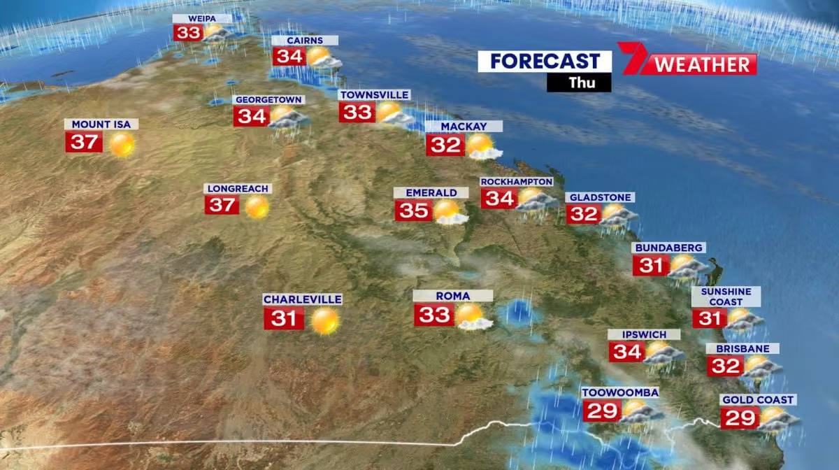
It's Tuesday, and it's going to be a hot one!
Western QLD close to 40 degrees with strong winds and extreme fire dangers over the Darling Downs.
Seabreezes will keep coastal parts of the SE in the low to mid 30s.
Keep those fluids up folks, and don't forget your pets! -
Tony Auden
@TonyAuden
Your Monday forecast..
Sunny and warming up in the southeast.
High fire dangers for much of western Queensland. -
Tony Auden
@TonyAuden
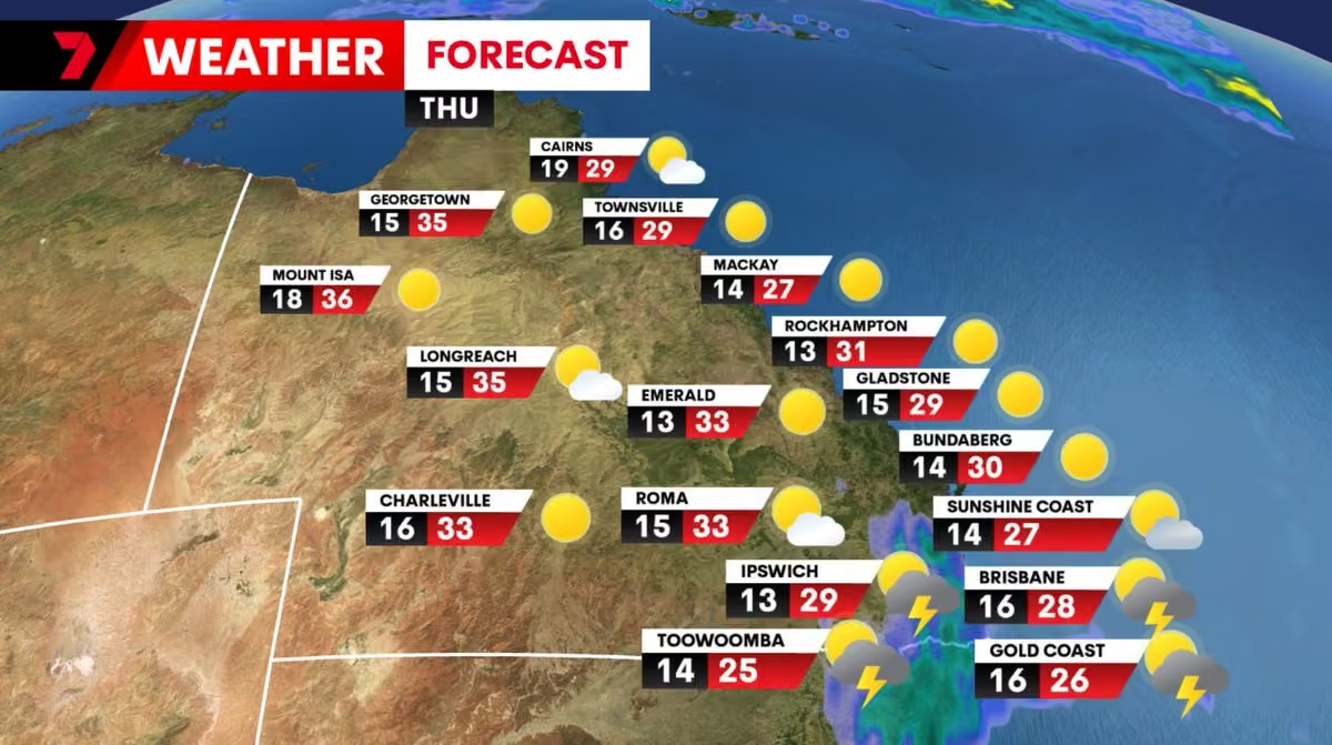
Your Thursday forecast..
Some wet weather on the way!
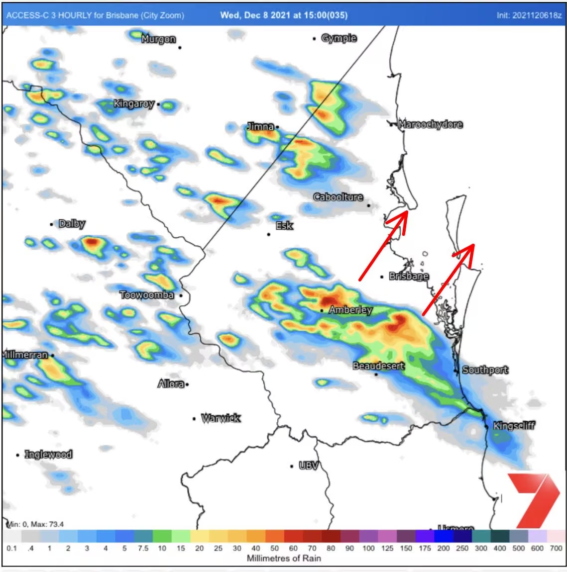
Afternoon storms, with the biggest cells from the Sunshine Coast up to the Capricornia. Weaker showers and storms, then some later thundery rain around Brisbane and the Gold Coast.
Extreme fire dangers in the west. -
Tony Auden
@TonyAuden
It’s Wednesday!
Mostly sunny and staying hot in the southeast.
The odd rogue storm on the ranges as fire dangers climb inland. -
Tony Auden
@TonyAuden
Your Wednesday forecast..
Cloud thickening up this afternoon in the southeast.
The odd light shower on the Central and Herbert and Burdekin coasts. -
Tony Auden
@TonyAuden
Your Monday forecast..
Even hotter in the southeast today. A very slim chance of an afternoon showers or storm, but they should be very few and far between, so I’ve left them off the icons here.
A cooler change is due early Tuesday morning. -
Tony Auden
@TonyAuden
Your Wednesday forecast..
Very isolated showers and storms over the southern ranges and inland parts of the southeast this afternoon. I don’t think we’ll see much reach the coast. -
Tony Auden
@TonyAuden
It’s Tuesday!
Warming up with more sunshine in the southeast.
Storms easing back in the far west. -
Tony Auden
@TonyAuden
Your Monday forecast..
A bit more sunshine and slightly warmer in the southeast.
Showers on the tropical coast and storms in the far west. -
Tony Auden
@TonyAuden
It's Wednesday!
A bit cooler and cloudier in the southeast, with a couple of passing showers.. but don't expect much rain.
A band of storms sweeps across the southern interior. -
Tony Auden
@TonyAuden
Your Tuesday forecast..
Partly cloudy and a degree or so cooler in the southeast today. A couple of lingering showers along the central and tropical coasts. -
Tony Auden
@TonyAuden
It’s Thursday!
A cooler change and a couple of hit and miss showers and storms in the southeast today.
Rainfall will be patchy, but hopefully a few drops for some thirsty gardens and lawns out there! -
Tony Auden
@TonyAuden
Your Wednesday forecast..
Sunny and heating up in the southeast, though seabreezes will keep coastal spots in the high 20s. -
Tony Auden
@TonyAuden
So great to see QLD teams in the AFL and NRL grand finals!
Heat could affect both games.
A warm 28° at the MCG on Saturday.
Then western Sydney pushes up to 35° on Sunday, but that’ll drop back to the high 20’s for kickoff at Accor Stadium.
Go Lions and Broncos!!! 🦁🐎 -
Tony Auden
@TonyAuden
Your Tuesday forecast..
Sunny and warming up in the southeast. The odd shower still possible around Cairns.
Onya Lachie Neale!!! 🦁 -
Tony Auden
@TonyAuden
It’s Thursday!
Heating up in the southeast, though too temperatures could vary on the coast if seabreezes get going early.
A cooler change reaches the Gold Coast tonight. -
Tony Auden
@TonyAuden
Your Monday forecast..
Mostly sunny in the southeast with clear skies remaining for much of the state.
Showers remain around Cairns. -
Tony Auden
@TonyAuden
Your Monday forecast..
Staying cooler with the odd brief passing shower in the southeast.
High fire dangers remain inland. -
Tony Auden
@TonyAuden
How was that thunder in the SE last night?!?
Today, thunderstorms taking off on the ranges, and could push through inland spots. They should struggle to reach the coast. -
Tony Auden
@TonyAuden
Hmmm.. those inland storms are picking up some steam this evening.
I wouldn’t be surprised if it all reaches the southeast and brings a few drops of rain overnight.
Might be worth bringing the washing in! 👕🩲 -
Tony Auden
@TonyAuden
Your Monday forecast..
Showers and storms are still possible in the SE this afternoon, though may be suppressed after rain this morning.
Fire weather warnings have been issued for southern inland districts. -
Tony Auden
@TonyAuden
Extreme to catastrophic fire dangers over the Channel Country, Maranoa & Warrego and Darling Downs districts today! 🔥
Any fires that do form will be hard to control, and potentially dangerous.
This is an ominous sign so early in the fire season! -
Tony Auden
@TonyAuden
Some welcome rain and storms across parts of the SE this morning.
We still have the chance of more showers and storms this afternoon.. BUT.. this morning’s activity may have “mixed the atmosphere” and taken away some of that instability.
Let’s see what happens later! -
Tony Auden
@TonyAuden
Sunny in Brisbane, stormy on the Gold Coast. ☀️⛈️
-
Tony Auden
@TonyAuden
We had widespread showers and storms in the southeast yesterday, with the odd borderline severe cell.
Today will be different.
Much drier, sunnier and warmer... BUT.
We should see a narrow strip of instability develop along the coastal stretch this afternoon.
Tony Auden
@TonyAuden
There won't be many storms, but if they do form, they could rapidly become severe before heading offshore quickly.
If it gets too dry we may not see any storms at all.
A low probability, but high impact day.
Let's see how it pans out!
📸: CAPE, 4pm, GFS model. -
Tony Auden
@TonyAuden
Storms are now firing up across southeast Queensland! ⛈️
We've had a few reports of hailstones around 1.5cm so far with a cell near the Brisbane CBD around 1:30pm. (A reminder that the threshold for storm warnings is 2cm, or marble sized hail.)
Tony Auden
@TonyAuden
A bigger band of storms is building on the ranges, and should push towards the coast later this afternoon and evening.
Hopefully a few drops of rain for the garden, but we will need to watch for the odd severe cell in there. -
Tony Auden
@TonyAuden
Your Wednesday forecast..
A few more showers and storms over southern QLD today, with the main focus over the southeast.
The odd severe cell is possible (shouldn’t be too widespread), so watch for any warnings this afternoon. -
Tony Auden
@TonyAuden
Your Monday forecast..
A mostly dry morning, then some showers, and the odd isolated inland storm, developing across the southeast this afternoon.
We should see a few more storms later in the week. -
Tony Auden
@TonyAuden
It’s Wednesday!
(I may have said the wrong day on air last night 🤦♂️)
A few more sunny breaks and slightly warmer in the southeast today. -
Tony Auden
@TonyAuden
Your Monday forecast..
Still a few showers and staying cool in the southeast. Cairns could also see a couple of drops.
Go Matildas!!!! -
Tony Auden
@TonyAuden
Trying to keep up with the energy of my on air guests tonight! 🧨
-
Tony Auden
@TonyAuden
Your Tuesday forecast..
Patchy cloud and odd coastal shower returning to the southeast this afternoon. -
Tony Auden
@TonyAuden
Has Spring arrived already?
Mostly sunny and warm across southern Queensland today.
A few showers lingering around Cairns and the North Tropical Coast. -
Tony Auden
@TonyAuden
It’s Tuesday!
Staying windy around the Capricornia and Wide Bay as showers remain for Mackay and Townsville.
In the southeast.. a few more sunny breaks, with the odd shower on the coast. -
Tony Auden
@TonyAuden
Your Monday forecast..
Cooler, cloudier and windier for much of Queensland. Rain around Roma, Emerald and Rockhampton, with showers for remaining coastal spots.
Rug up folks! -
Tony Auden
@TonyAuden
It's Wednesday, and the sun has returned!
Patchy inland fog clearing to blue skies, and a slightly warmer day over southern Queensland. -
Tony Auden
@TonyAuden
Your Monday forecast..
Showers along much of the Queensland coast today.
For the southeast, they’re most likely right on the coast this morning, then the odd sprinkle pushing further inland into the afternoon and evening. -
Tony Auden
@TonyAuden
Your Wednesday forecast..
Cloud and a few showers developing along parts of the east coast.
For the southeast, they'll be most frequent up towards the Moreton Bay Region and Sunshine Coast. -
Tony Auden
@TonyAuden
It’s Tuesday!
Sunny skies for much of Queensland today. -
Tony Auden
@TonyAuden
Your Thursday forecast..
Cloud thickening across southern districts later, but staying dry and mild for much of Queensland. -
Tony Auden
@TonyAuden
It's Wednesday, and the sun is poking through again!
Cloud continues to clear in the southeast through the day as we warm up.
Some lingering showers and weak storms from the Wide Bay up towards the Central Coast. -
Tony Auden
@TonyAuden
Rain periods across much of eastern Queensland today, including the southeast.
There'll be a few dry breaks, but best to keep the brolly handy all day. ☔️
We should see a peak this afternoon and evening, before it clears soon after sunrise tomorrow (Wednesday).
Tony Auden
@TonyAuden
Here are the latest forecast rain totals from the ACCESS C model, and it looks like most spots should get 20 to 30mm. As usual, there'll be a bit of variation across the region.
My lawn is looking forward to a drink! -
Tony Auden
@TonyAuden
Your Monday forecast..
Rain and storms continue through northern and central Queensland, also developing on the tropical coast.
Cloudy with showers in the southeast before light rain picks up tomorrow. -
Tony Auden
@TonyAuden
A windy and cooler day in the southeast today! 🥶
Gusts up to 50kph this morning, then easing.
But combined with some high level cloud, that should keep temperatures in the teens for much of the day.
Tony Auden
@TonyAuden
A few more sunny breaks this afternoon may see us spike briefly up to the official forecast tops in the low 20s, but I’ll be packing an extra layer!
📸 Forecast temp at midday, ACCESS C model -
Tony Auden
@TonyAuden
It’s Wednesday!
Slightly warmer with a bit more high cloud in the southeast.
Light rain in the southwest. -
Tony Auden
@TonyAuden
Your Monday forecast..
Sunny, mild and breezy in the southeast. Westerlies gusting over 40kph this afternoon.
Patchy cloud for the central and tropical coasts. -
Tony Auden
@TonyAuden
Well I did think we could get a splash of colour at sunset tonight, but I may have undersold it this time!!!
Plenty of great shots from across the southeast.
How about this one from Hamilton!
📸 Harry Linari -
Tony Auden
@TonyAuden
It’s Tuesday, and it’s a little chilly!
A frosty start, then plenty of blue sky through the middle of the day before high cloud thickens over southern Queensland late.
Cooler top temperatures despite the sunshine. -
Tony Auden
@TonyAuden
Your Monday forecast..
More sunshine and mild after a cool morning.
A cooler change arrives tomorrow. -
Tony Auden
@TonyAuden
It’s Tuesday!
Some patchy fog through inland parts of the southeast this morning, then sunny breaks for the rest of the day.
A slim chance of a rogue shower near the coast this afternoon, but it’ll be short lived if it happens. -
Tony Auden
@TonyAuden
Your Monday forecast..
By all means pack the brolly, but there’s no guarantee you’ll need to use it. ☂️
A few showers for the Sunshine Coast and bayside this morning, spreading inland later in the day.. but they should be few and far between.
Tony Auden
@TonyAuden
Edit: that brolly will probably be needed by most people on the Sunshine Coast and by the bayside this morning! 🌧️
-
Tony Auden
@TonyAuden
So those showers are a bit more vigorous than first thought.
Heaviest on the Sunshine Coast and by the bayside this morning. Then expect a more even spread pushing inland, but with more dry breaks, into the afternoon.
📸 8:29am Brisbane radar -
Tony Auden
@TonyAuden
It’s Tuesday!
More sunny breaks returning to the southeast today, though the odd shower is still possible on the coast. -
Tony Auden
@TonyAuden
How nice is it to have some colour back in the sky?!?
This shot from sunset yesterday at Shorncliffe Pier.
A slight smoky smell around this morning, but it should continue to clear through the day as southeast winds set in. -
Tony Auden
@TonyAuden
Your Wednesday forecast..
Sunny and slightly warmer in the SE, with smoke haze likely from Brisbane down to southern suburbs.
Showers developing in Cairns. -
Tony Auden
@TonyAuden
Still plenty of smoke around Brisbane this morning.
Winds just above the surface (1km elevation on the map here) are set to turn NW'ly later today, which means smoke is more likely to affect the southern suburbs, and down to Logan, the bayside and possibly even the Gold Coast.
Tony Auden
@TonyAuden
Westerly winds remain tomorrow, before it all turns easterly, and should take the worst of the smoke inland, on Friday.
Well worth keeping the windows closed and the puffer handy if you need it! -
Tony Auden
@TonyAuden
Your Monday forecast..
Sunny across Queensland today after a chilly start.
More smoke haze likely in the southeast as light winds continue. -
Tony Auden reposted
7NEWS Queensland
@7NewsBrisbane
Floodwaters are still on the move out west. The rain from the start of the year is long gone, but the water is just now starting to reach Lake Eyre, a journey of over 1500km. 7news.com.au @TonyAuden #7news
-
Tony Auden
@TonyAuden
It’s Wednesday!
Slightly warmer during the daytime as winds ease out over southern districts.
Showers in the tropics. -
Tony Auden
@TonyAuden
So great to be back at @TheEkka Rural Discovery Day for the first time in 4 years!!
Thanks kids (and farm animals) for sharing plenty of energy and excitement this morning!
Now only 81 days until the main event! -
Tony Auden
@TonyAuden
Here’s my tribute to TV legend Ray Wilkie who has sadly passed away, aged 98.
No doubt many of you will have memories of his sharp wit on air over many years.
I was lucky enough to meet him briefly a few years back.
My best wishes go to Ray’s family. -
Tony Auden
@TonyAuden
Your Monday forecast..
Another mostly sunny and mild day for much of Queensland.
Cool in the shade, but warm in the sunshine across the southeast. -
Tony Auden
@TonyAuden
It’s Thursday!
Sunny skies but a little cooler in the southeast today. -
Tony Auden
@TonyAuden
Well the rain came!
Falls up around 100-150mm for parts of the Gold Coast overnight.. with many other spots picking up over 50mm.
The heaviest stuff is now contracting down to the Gold Coast, where it should linger for a few hours, then clear into the afternoon. -
Tony Auden
@TonyAuden
Rain is on the way tonight, and it could be heavy at times.
Expect this evening's showers to spread to steadier rain over the next few hours, and continue through to the early morning.
It should clear by lunchtime, though latest guidance has it drying up around 8 or 9am now.
Tony Auden
@TonyAuden
In that time, we could see some falls over 100mm, especially around the Gold Coast, with 30 to 50mm a more accurate range for the broader SE as a whole.
Some pockets of flash flooding are possible with those heavier falls.
Please take it easy on the roads in the morning!! 🚗 -
Tony Auden
@TonyAuden
Your Monday forecast..
Showers and weak storms lingering across southern Queensland.
More dry breaks in the southeast than yesterday, but it picks up across the Darling Downs and Maranoa and Warrego. That should eventually move to the coast as rain tonight. -
Tony Auden
@TonyAuden
It’s Thursday!
A bit more cloud and a few showers developing along the southern Queensland coast today. -
Tony Auden
@TonyAuden
Brrrrrr!! That was a chilly start! ❄️
It’ll feel a bit warmer with lighter winds and sunny skies over southern Queensland today. -
Tony Auden
@TonyAuden
Your Monday forecast..
Sunny but cold in the south, with strong winds on the ranges and exposed parts of the southeast this afternoon.
Winter is making an early appearance! 🥶 -
Tony Auden
@TonyAuden
Your Wednesday forecast..
🌞 -
Tony Auden
@TonyAuden
Your Monday forecast.
Showers in the southeast and along the central and tropical coasts.
Staying windy on the beaches. -
Tony Auden
@TonyAuden
It’s Thursday!
Partly cloudy but mostly dry in the southeast as winds pick up on the beaches again.
A couple of showers around Cairns and the Whitsundays. -
Tony Auden
@TonyAuden
It’s Tuesday!
Cooler, cloudier and windy on the beaches in the southeast today.
Showers and inland storms persist across the tropics. -
Tony Auden
@TonyAuden
I’m baaackkkk!
Partly cloudy in the southeast today with strong winds on the beaches this afternoon.
Rain and storms in the tropics, especially near Townsville this morning. -
Tony Auden
@TonyAuden
How about that sunset?!???
These shots from beautiful Tangalooma. -
Tony Auden
@TonyAuden
While it's still "hot", westerly winds have brought a significant drop in humidity today.
Here you can see the dewpoint (or absolute humidity) dropping rapidly this afternoon in Brisbane.
At one point, Ipswich was 30 degrees, but felt more like 23!
I do love this time of year! -
Tony Auden
@TonyAuden
It’s Thursday!
Early showers and storms for the southeast, they should clear up to the Sunshine Coast into the afternoon.
Severe storms possible around the Wide Bay and Capricornia. -
Tony Auden
@TonyAuden
Red sky in the morning.. shepherd’s warning!
Storms on the cards for the next couple of days, worth keeping an eye on the weather if you’re out and about.
This shot over Brisbane a short time ago. -
Tony Auden
@TonyAuden
First time on the bike in a few months and it was worth it for this sunrise!
Looks like there’s still a tiny splash of colour left over from the volcano eruption in January last year.
📸 Taken from somewhere between Kedron Brook and the Gateway. -
Tony Auden
@TonyAuden
It’s Tuesday!
Mostly cloudy over southern QLD today with a few storms on the ranges. Tops may stay below the numbers on the map in the southeast here if that cloud thickens up early enough. -
Tony Auden
@TonyAuden
Your Monday forecast..
Hot and dry with patchy cloud for much of Queensland today. -
Tony Auden
@TonyAuden
Your Wednesday forecast..
Cooler with showers in the southeast, clearing towards the Sunshine Coast this afternoon and evening.
Only isolated showers for the tropical coast as the heaviest rain clears up to Cape York Peninsula. -
Tony Auden
@TonyAuden
Plenty of showers across the southeast overnight.. my lawn is happy!
They should clear north to the Sunshine Coast this afternoon as we dry up for the next couple of days. -
Tony Auden
@TonyAuden
Your Monday forecast..
Mostly sunny and staying hot in the southeast. Showers picking up for coastal spots north of the Sunshine Coast. -
Tony Auden
@TonyAuden
Severe storms are closing in on the southeast this evening.
At the moment, radar is detecting hail up to 4cm in the cell north of Ipswich.
It's expected to move closer to coastal areas, likely hitting areas between Brisbane and Logan just after 6pm. -
Tony Auden
@TonyAuden
Your Wednesday forecast..
Staying hot in the southeast with patchy inland showers and storms into the afternoon (not shown on the icons here).
Isolated showers and storms continue along the coast and ranges. -
Tony Auden
@TonyAuden
With the cloud starting to clear over NW QLD, we can now get an idea of the scale of the flooding from space.. and it's nothing short of phenomenal!
This image here shows the Gulf coast on a clear day, with no flooding, in December. The red dot shows where Burketown is.
Tony Auden
@TonyAuden
This image is from 11 March, the dark blue shades show the floodwaters.
As you can see, it's not just the rivers flooding, but the whole area around Burketown has turned into a huge floodplane, pushing 50km wide in some spots, then flowing out into the Gulf of Carpentaria.
Tony Auden
@TonyAuden
There is simply nowhere for people, or livestock, in the path of this water to go.
The water will take weeks to flow out of the rivers and finally subside.
📸 Nasa Worldview -
Tony Auden
@TonyAuden
Your Monday forecast..
Patchy showers in the southeast as some pockets of blue sky return. Bigger storms from about Gympie up towards the Capricornia. -
Tony Auden
@TonyAuden
Severe thunderstorms are closing in on the southeast this afternoon. ⚡️
Warnings are current, you can check the latest at www.bom.gov.au/products/IDQ21035.shtml. -
Tony Auden
@TonyAuden
The first round of rain has cleared.
For the most part falls were a bit lighter than expected last night, though there were some totals over 50mm around the Redcliffe Peninsula.
Tony Auden
@TonyAuden
More showers and storms possible today and tomorrow, which should take the totals for this event up to the 30-50mm I've been talking about all week.
It'll be patchy, so some areas could get a heavy dump, while the suburb next door misses out.
Tony Auden
@TonyAuden
With a few rounds of showers.. most spots will get at least a couple of drops this weekend.
📸 Forecast rain totals through the weekend, ACCESS C model. -
Tony Auden
@TonyAuden
Yuk!!!!
A steamy old night across SE QLD last night. 🥵
While the official Brisbane minimum of 24.1° seems muggy enough, it felt more like 29° or 30° for most of the night.
It stays muggy today, but light rain could bring some relief into the afternoon and evening. -
Tony Auden
@TonyAuden
It's Thursday!
Rain spreading across Queensland today, as the heavy falls finally ease late in flooded northwest parts of the state.
Showers for much of the east coast, though the southeast is looking cloudy and humid, with some light rain at times. -
Tony Auden
@TonyAuden
Your Wednesday forecast..
Cloudy and muggy in the southeast, but likely staying below the official forecast maximums here for most of the day.
Heavy rain remains in the northwest, with steady rain streaming across central districts. -
Tony Auden
@TonyAuden
It's been a while since I could say this, but rain is on the way across large parts of Queensland! 🌧️
Very serious flooding is set to continue in the Gulf near the monsoon low driving it all, and many towns will continue to be cut off for weeks to months.
Tony Auden
@TonyAuden
We're also expecting moderate to heavy falls extending south later this week. While some flooding is possible, given the dry Summer away from the tropics.. I imagine this will be welcomed by many people.
📸 Forecast rain totals, next 7 days, EC model. -
Tony Auden
@TonyAuden
Your Monday forecast..
Sunny and hot for much of Queensland. Monsoonal rain continues in the tropics, including Cairns. -
Tony Auden
@TonyAuden
It’s Thursday!
A few showers and weak inland storms for the southeast today, bigger storms likely on the ranges.
Heavy rain picks up in the far northwest of the state. -
Tony Auden
@TonyAuden
A few showers and weak storms across the southeast this evening.
No warnings current at the moment.
They could last the next few hours.
Hopefully a few drops for the garden! 🌧️ -
Tony Auden
@TonyAuden
It’s Wednesday, and we’re now into Autumn! 🍁
A hotter day for southern districts to start the new season, as the tropics dry up too. -
Tony Auden
@TonyAuden
Your Monday forecast.
Mostly sunny and above average top temperatures over southern Queensland for the second last day of Summer.
Showers on the central and tropical coasts as a low moves further out into the Coral Sea. -
Tony Auden
@TonyAuden
After a bit of a false start yesterday, it looks like forecast showers should really ramp up across the southeast today (Friday).
📸: Forecast rain for Friday (ACCESS C model)
Tony Auden
@TonyAuden
With Mt Stapylton out, try the Brisbane Airport radar instead
It’s more exposed to the coast and does a much better job than Marburg.
📸1: Brisbane Airport radar - showing a big cluster of showers moving north from the Gold Coast
📸2: Marburg radar - showing not much 🤷♂️ -
Tony Auden
@TonyAuden
It’s Wednesday!
Morning showers clearing inland for the southeast again today. Showers also persist in the tropics, with heavier rain around the Gulf. -
Tony Auden
@TonyAuden
Your Tuesday forecast..
Showers easing in the southeast this afternoon, but persist for the central and tropical coasts through most of the day. -
Tony Auden
@TonyAuden
It's Wednesday!
Cooler in the southeast today with the odd passing shower.
Breezy with a hazardous surf warning remaining on the beaches.
The odd storm remaining around the Capricornia this afternoon, with monsoonal rain in the tropics. -
Tony Auden reposted
7NEWS Queensland
@7NewsBrisbane
Tomorrow’s weather forecast with 7NEWS meteorologist @TonyAuden. "Windy on the beaches." 7news.com.au #qldweather #7news
This media couldn't be displayed. See it on the original post. -
Tony Auden
@TonyAuden
More storms and rain areas across the southeast this evening.
Warnings are only current for the biggest cells inland.
It should all clear later tonight, then quieter tomorrow. -
Tony Auden
@TonyAuden
Storms are on the way for southeast Queensland today! ⛈️
The highest instability will be north of Brisbane, and dangerous supercell thunderstorms are possible in one or two locations there.
Severe storms are still possible further south behind a weak SE wind change.
Tony Auden
@TonyAuden
An upper jet stream will also provide a bit of extra oomph for any storms that do get going.
Storms should last into the evening, before easing overnight.
Hopefully a few drops of rain for thirsty gardens and lawns out there!
📸 Instability (CAPE) 3pm, ACCESS C model -
Tony Auden
@TonyAuden
Your Valentine's Day Tuesday forecast..
Storms picking up in the southeast corner this afternoon and evening.
Severe cells are possible, and hopefully some decent rainfall for many spots. -
Tony Auden
@TonyAuden
Cyclone Gabrielle is now a severe category 3 system!
No clear eye this morning, though water vapour satellite imagery shows it is trying to get organised.
No change to the track.
Expect a bump in NE swells on our beaches today. -
Tony Auden
@TonyAuden
It’s Thursday!
Mostly cloudy with the odd brief shower for the southeast today.
Winds picking up from the Whitsundays to K’gari Fraser Island today, with big waves in the SE from tomorrow. -
Tony Auden
@TonyAuden
Tropical Cyclone Gabrielle has now been named in the Coral Sea!
She should intensify quickly, likely reaching severe category 3 by late Thursday, then hurry away to the southeast.
The main impacts will be gusty winds and powerful waves over the next few days. -
Tony Auden
@TonyAuden
It’s Tuesday!
A little more cloud and a degree or so cooler than yesterday in the southeast.
Showers for the central and tropical coasts with storms contracting to the far west. -
Tony Auden
@TonyAuden
Here’s the latest on our cyclone threat for Queensland, and why we’re confident it’ll quickly turn away from the coast.
7NEWS Queensland
@7NewsBrisbane
7NEWS meteorologist @TonyAuden is providing an update on the cyclone expected to sideswipe the Queensland coast. "It may become a severe cyclone, but should stay 100kms off the coast before hurrying away over the weekend. 7news.com.au #qldweather #7news
This media couldn't be displayed. See it on the original post. -
Tony Auden
@TonyAuden
It's looking very likely we'll have an intense tropical cyclone sideswipe the Queensland coast later this week.
A low near the Solomon Islands should move closer, with a high chance it'll be named a cyclone by Wednesday.
Tony Auden
@TonyAuden
The name could be Freddy, Gabrielle or Herman (2 other lows off Western Australia are racing this system to be named first).
It's then likely to "recurve" and turn parallel to, then away from the coast later this week.
Tony Auden
@TonyAuden
On this track, the main impact will be gusty winds and big waves, while heavy rain isn't likely.
Having said that, we do need to keep a watch for any change in track.
I'll have the latest model updates tonight on @7NewsBrisbane. -
Tony Auden
@TonyAuden
Your Monday forecast..
Mostly sunny and hotter than average in the southeast, with widespread storms through inland spots, and showers on the central and tropical coasts. -
Tony Auden
@TonyAuden
SOME relief from the heat is here, thanks to thick cloud and light rain.
Most spots have already reached the early 30’s, but shouldn’t climb too much further.
Still worth keeping the fluids up, but it shouldn’t be a scorcher like yesterday.
📸
1. Cloud cover
2. 1pm Temp -
Tony Auden
@TonyAuden
Well that was a more interesting chat than I originally had planned! 😂
The Morning Show
@morningshowon7
Our chat with @7NewsAustralia meteorologist @TonyAuden about all the recent sticky weather took an unexpected turn south... 😲
-
Tony Auden
@TonyAuden
Your Monday forecast..
Still hot and muggy across much of Queensland.
Big storms in the west, grading down to a couple of passing showers in the southeast. -
Tony Auden
@TonyAuden
It’s Wednesday!
A hot one with much more isolated afternoon showers and weaker storms for inland parts of the southeast, and west of the ranges today.
Rain is much less likely to reach the coast. -
Tony Auden
@TonyAuden
Those storms keep closing in on the SE!
We should get some thundery rain for most of the region this evening.
The Gold Coast looks like it'll get the most, with lighter falls further north.
Time to get the washing off the line! -
Tony Auden
@TonyAuden
Storms over southern inland QLD this afternoon.
A warning has just been issued for the southern Darling Downs.
These storms should mostly weaken when pushing off the ranges, but you can't rule out the odd cell reaching the coast later into the afternoon and evening. -
Tony Auden
@TonyAuden
Your Tuesday forecast..
A more active storm day across southern inland QLD, with the odd severe cell possible.
Storms should stay mostly inland for the southeast. -
Tony Auden
@TonyAuden
It’s Tuesday!
Mostly sunny on the southeast with breezy winds continuing on the beaches.
Widespread storms out west. -
Tony Auden
@TonyAuden
Your Monday forecast..
Partly cloudy in the southeast with the odd shower along the coast.
Storms inland and a wet day on the North Tropical Coast. -
Tony Auden
@TonyAuden
A SE wind change should keep storms away, or at least weaker, for the Gold Coast and Brisbane this afternoon.
The biggest cells are likely ahead of that change from the Sunshine Coast further north.
Here you can see CAPE (or storm potential) dropping behind that wind change. -
Tony Auden
@TonyAuden
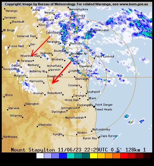
Another restless night for some as storms swept across the southeast.
Here’s what it looked like on the radar. -
Tony Auden
@TonyAuden
Your Tuesday forecast.
Severe storms likely from the Sunshine Coast up to the Capricornia, with weaker storms or showers around Brisbane and the Gold Coast. -
Tony Auden
@TonyAuden
Thundery rain is moving across the southeast tonight, right on cue!
Expect a few hours of rain, and a bit of a light show.
Warnings are current for damaging winds and heavy rain, so please be careful if you’re out and about. -
Tony Auden
@TonyAuden
Big storms could be on the way for southeast Queensland this afternoon! ⛈️
Today’s forecast was always going to be a tricky one. Dry westerly winds were originally thought to keep storm activity sporadic, but overnight rain has thrown a spanner in the works!
Tony Auden
@TonyAuden
Enough has fallen that it could evaporate again with the heat today and provide more fuel for afternoon storms.
So I think we’ll see a decent spattering of thunderstorms along the coastal strip this afternoon, and some very big supercells in the mix here and there too.
Tony Auden
@TonyAuden
Don’t worry about the bullseye over Brisbane, it’s more the line of instability running right across the region.
Please keep an eye out for warnings. One advantage, more storms means we could get some extra relief from the heat. 🥵
📸 CAPE (instability), 2pm, ACCESS C -
Tony Auden
@TonyAuden
It's Thursday, and it's going to be hot!
Temperatures soaring over the tropics and eastern districts.
Storms are possible in the SE, but should more sporadic than last night. Having said that, we could see some big severe cells in a couple of places. -
Tony Auden
@TonyAuden
The battle lines are drawn across SE QLD! Hot westerly winds (dark red arrows), battling the coolER coastal seabreezes (pink arrows).
The westerlies should win the battle for the most part, so it’ll be hot! 🥵
Ipswich tracking for 39°, Brisbane 37°, and coastal spots around 35° -
Tony Auden reposted
7NEWS Queensland
@7NewsBrisbane
Tomorrow’s weather forecast with 7NEWS meteorologist @TonyAuden. "Brisbane could have its hottest day in three years." 7news.com.au #qldweather #7news
This media couldn't be displayed. See it on the original post. -
Tony Auden
@TonyAuden
Time to get the washing off the line! 👕👗
Storms are closing in this evening, and should arrive a bit earlier than first thought.
This current line could reach coastal areas a bit after 10pm, with more storms possible overnight, likely clearing around sunrise. -
Tony Auden
@TonyAuden
It’s Thursday and welcome to Summer.. I think?!? 🤷♂️
Rain and cold in the southeast. Some spots could post new records for their coldest December day!
Strong winds too. Severe weather warnings are current for damaging wind gusts and dangerous surf on the coast. -
Tony Auden
@TonyAuden
It’s Tuesday!
Storms are still possible in the southeast, but should be much quieter, and more sporadic, than yesterday.
Rain and storms do pick up from about Bundaberg north to the tropics. -
Tony Auden
@TonyAuden
From inside the whale’s mouth at Mount Coot-tha!
-
Tony Auden
@TonyAuden
Incoming! ⛈️
A line of storms is sweeping across the southeast this afternoon and evening.
It hit the Gold Coast a short time ago, and should reach Brisbane around 5:30pm, before continuing north.
Severe storm warnings are current for damaging winds, large hail and heavy rain. -
Tony Auden
@TonyAuden
Your Monday forecast..
Hot and humid with storms across much of Queensland today. Severe cells are possible over a large area (including the southeast), so please watch for any warnings later in the day. -
Tony Auden
@TonyAuden
It looks like this high level cloud is trying to take the oomph out of any storms in SE QLD today.
At the moment we have some light rain and small punchier showers or weak storms. -
Tony Auden reposted
7NEWS Queensland
@7NewsBrisbane
Tomorrow’s weather forecast with 7NEWS meteorologist @TonyAuden. "Blue skies return and the heat bumps up a little bit." 7news.com.au #qldweather #7news
This media couldn't be displayed. See it on the original post. -
Tony Auden
@TonyAuden
Your Monday forecast.
Hot and windy with extreme fire dangers for the southeast. Morning high cloud, then mostly sunny this afternoon.
Storms rain along the coast and ranges north of about Bundaberg. -
Tony Auden
@TonyAuden
A few showers and storms across SE QLD today. ⛈️
The odd severe cell is a chance, but morning cloud and rain is starting to take a bit of the oomph out of the atmosphere, so any bigger storms should be few and far between.
📸 Forecast precipitation, 3pm, ACCESS C -
Tony Auden
@TonyAuden
I’ve been cartooned!
Thanks to Callum Terry for the illustration. I think he may have taken a couple of kg off too. 😁 -
Tony Auden
@TonyAuden
Your Wednesday forecast..
Sunny and windy this afternoon in the southeast.
The maximums here look hot, but the wind will actually bring a slight chill in the shade.
A fire weather warning is also current for the southeast coast. 🔥 -
Tony Auden
@TonyAuden
A fire weather warning has now been issued for SE QLD! 🔥
Wind gusts over 50kph could make any fires that do start hard to control, so our fire danger rating in now Extreme.
This is something we'll need to watch in coming months, if forecast Summer rain sets in late. -
Tony Auden
@TonyAuden
It’s Thursday!
Still the odd shower for the Sunshine Coast this morning, but otherwise sunny breaks in the southeast.
Storms in the far west of the state. -
Tony Auden
@TonyAuden
Here’s what to expect with tonight’s total lunar eclipse, or blood moon. 🌝
7:09pm: partial eclipse begins.. the moon starts to disappear and get a red tinge
8:16pm: total eclipse begins.. moon is totally red
9:41pm: total eclipse ends
10:49pm: partial eclipse ends
Tony Auden
@TonyAuden
My favourite part is just before the total eclipse where you have plenty of red, but also a strip of bright white - like in this photo I took last year with Q1 in the foreground.
Tonight, this would be around 8pm, with the moon low in the northeast sky.
Tony Auden
@TonyAuden
Cloud should thicken with showers this afternoon, then start to clear this evening. It won’t be perfectly clear, but you should get at least a few chances to view it all.
This picture shows the forecast cloud at 8pm. (ACCESS C model). -
Tony Auden
@TonyAuden
It’s Tuesday!
A few showers, and the odd inland storm, developing in the southeast, and ranges, from late morning to mid afternoon.
Cloud should start clearing this evening for the lunar eclipse. -
Tony Auden
@TonyAuden
It’s Tuesday, and it’s a bit wet! ☔️
Rain and the odd rumble of thunder in the southeast, likely clearing by mid afternoon.
Storms continuing from the Sunshine Coast to the tropics until this evening. -
Tony Auden
@TonyAuden
I’m back!
Cloud thickening in the southeast today as storms build out west.
Rain and storms reaching the coast by tomorrow morning. -
Tony Auden reposted
RACQ
@RACQOfficial
The recent heavy rain and flooding across southern Qld is a reminder we’re in the midst of our third La Nina weather event. We caught up with @Channel7 Meteorologist @TonyAuden to find out more about what’s in store this storm season👇www.racq.com.au/about-us/news-and-media/news/2022/10/stor…
-
Tony Auden
@TonyAuden
We’re already expecting storms this weekend, but one scenario has a trough/low developing over SE QLD.
If this happens, we COULD see falls of 2-300mm, flash flooding and some riverine flooding.
It’s an outside chance, but one to watch!
📸 Accumulated rainfall to Tuesday, EC -
Tony Auden
@TonyAuden
Some big storms over western Queensland in the past couple of days, and we have more on the way today. ⛈️
Here’s the “thunderstorm potential” or CAPE for more interested weather watchers, showing lots of energy in the atmosphere for storms out west at 4pm today. -
Tony Auden
@TonyAuden
Your Thursday forecast..
More big storms inland, spreading to showers and weaker storms near the coast. -
Tony Auden
@TonyAuden
It’s Wednesday!
More severe storms inland, spreading to some steady, but mostly light, rain in the southeast later. -
Tony Auden
@TonyAuden
Your Monday forecast..
Showers, and isolated afternoon storms, across the southeast, and coast and ranges up to the Capricornia. -
Tony Auden
@TonyAuden
Your Thursday forecast..
A couple of showers in the southeast, most likely near the coast.
A shower or two in Cairns, and rain and storms developing late in the far west. -
Tony Auden
@TonyAuden
It’s Tuesday, and there’s a little bit of sunshine!
Partly cloudy skies with the odd isolated shower along the coast and ranges today, a bit wetter on the Central Coast. -
Tony Auden
@TonyAuden
When weather and sport combine! ⛈️🏈
A fun morning teaming up with JT and Get Ready Queensland to chat disaster season preparation.
The kids at Nundah State School are ready for anything this season can throw at us! -
Tony Auden
@TonyAuden
Did anyone else spot the southerly wind change moving along the coast late yesterday?
Cold air undercutting warm air ahead of it triggered some showers and this impressive shelf cloud!
This shot from Burleigh Beach on the Gold Coast.
📸 Savannah Faulkner -
Tony Auden
@TonyAuden
Your Monday forecast..
Storms running from north of Brisbane, up to the Capricornia. Mostly cloudy with just the odd brief shower from Brisbane down to the Gold Coast. -
Tony Auden
@TonyAuden
Your Wednesday forecast..
Rain and storms with flash flooding, and possible river flooding, in far western Queensland.
Mostly cloudy with the odd brief shower in the southeast.
@7NewsBrisbane -
Tony Auden
@TonyAuden
Your Tuesday forecast..
Partly cloudy and mild in the southeast, with storms developing in the far west of the state.
@7NewsBrisbane -
Tony Auden
@TonyAuden
A cloudy and cool morning under a deck of high cloud in the SE, but it should clear.
Expect plenty of blue sky to return after lunchtime as we warm up again. 😎
📸 Forecast cloud, midday, ACCESS C model -
Tony Auden
@TonyAuden
So great to sit down and chat all things weather with @NoonanJustin!
And this time I didn’t have someone counting down in my ear, so we could cover it all in a lot more detail! 😊
Justin Noonan
@NoonanJustin
Episode #5 of The Weather Guru podcast features Channel 7 meteorologist & weather presenter @TonyAuden.
podcasts.apple.com/.../the-weather.../id1640815141
open.spotify.com/show/7xM4pP6VChy7nQ4VXlDmQK
music.amazon.com/.../the-weather-guru-podcast...
www.iheart.com/.../338-the-weather-guru-podcast.../
I had an absolute ball interviewing Tony.
#podcast #weather -
Tony Auden
@TonyAuden
After a wet and wild night we still have severe thunderstorm warnings current for the Gold Coast this morning.
Damage winds are still possible as a low spins up offshore.
📸 1: Storm warning area at 8:30am
📸 2: Rain radar
📸 3: Doppler wind radar showing low (red circle) -
Tony Auden
@TonyAuden
Still a bit going on this evening as storms spread to rain areas and dump heavy localised falls.
Severe thunderstorm warnings are current for inland parts of southeast Queensland.
It should clear to just isolated showers near the NSW border by tomorrow morning. -
Tony Auden
@TonyAuden
Concern is growing for the flooding in northern NSW.
The forecast totals here are from the EC model, but some high resolution modelling has falls reaching 3-400mm across the region into Friday morning.
If that happened, we're looking at another significant flooding event. -
Tony Auden
@TonyAuden
Wow!
How's this impressive spiral low and cloudband over eastern Australia at the moment?!?
It's bringing rain and storms across much of southern Queensland and New South Wales.
And it'll bring more unsettled weather to the Queensland coast tomorrow too. -
Tony Auden
@TonyAuden
It’s Wednesday!
Rain and storms over southern inland Queensland today, with light rain reaching the southeast this afternoon or evening. -
Tony Auden
@TonyAuden
Your Tuesday forecast..
Mostly sunny along the Queensland coast, with storms developing late for the far west of the state. -
Tony Auden
@TonyAuden
Don’t be surprised if you’re woken up by another clap of thunder early morning. ⚡️
We could see some showers and storms popping up in the early hours with the passage of a punchy upper trough.
Any rain should clear around 9 or 10am Saturday.
📸 Forecast radar, 5am, ACCESS C -
Tony Auden
@TonyAuden
Some showers and weak storms sweeping across the southeast this morning.
Expect it to ease into the afternoon with the odd sunny break returning after lunch. -
Tony Auden
@TonyAuden
It’s Wednesday!
Patchy cloud returning to the southern Queensland coastline, but staying mostly dry. -
Tony Auden
@TonyAuden
La Nina has now been declared by the Bureau of Meteorology.
No surprises here, but it does mean we're in for another wetter than average Summer, and increased chance of tropical cyclones. -
Tony Auden
@TonyAuden
Your Monday forecast..
Overcast skies for the southeast for the morning, the odd bit of blue through the afternoon.
The odd shower over southern districts, but not enough to include on any icons here. -
Tony Auden
@TonyAuden
It’s Wednesday!
Similar to yesterday in the southeast.. ie a bit more cloud than sunny breaks and the odd isolated shower here and there.
Storms developing in the far west this afternoon. -
Tony Auden
@TonyAuden
Your Tuesday forecast:
Mostly cloudy with showers near coastal parts of the SE this morning, then possible inland this afternoon.
Dry for the rest of Queensland (apart from the odd shower on the tropical coast). -
Tony Auden
@TonyAuden
The last of the rain is now clearing off the coast.
While you can’t completely rule out a brief shower later, it’s most likely going to stay dry into this evening for Riverfire. -
Tony Auden
@TonyAuden
Phwoar!!!!!!! 🤯
Riverfire is tomorrow night and the F/A-18F Super Hornets will play a key part in the show.
How’s this shot from their rehearsal today, taken by @ninologiudice?!? -
Tony Auden
@TonyAuden
Do I turn left or right for the pot of gold?!? 🤷♂️
-
Tony Auden reposted
Dave
@limewolfqld
Not much city to be seen this morning #bnefog @TonyAuden
-
Tony Auden
@TonyAuden
A few showers and weak storms through inland parts of southeast Queensland this afternoon.
No warnings issued, but expect a burst of heavy rain if you get one of the cells overhead through the rest of the afternoon. -
Tony Auden
@TonyAuden
Your Wednesday forecast..
A clearing shower this morning, then heavier showers and weak storms across the southeast this afternoon.
Slow moving cells could bring pockets of heavy rain. -
Tony Auden
@TonyAuden
It’s Tuesday, and there’s some rain on the way! ☔️
Showers or light rain picking up in the SE this afternoon and evening. Heavier showers and storms right across the southern inland, extending up to the tropics. -
Tony Auden
@TonyAuden
Your Monday forecast..
Morning showers in the southeast, easing through the afternoon.
A large band of storms, with possible severe cells, over far western districts. ⛈ -
Tony Auden
@TonyAuden
A slight language warning on this clip, but it’s all in good fun.
We technically had a few light flakes of snow on the Granite Belt last night! ⛄️
This video from Donnelys Castle, just north of Stanthorpe. Thanks to Kathy de Weger for sending it in. -
Tony Auden
@TonyAuden
Forecast showers are running a little ahead of schedule.
A line is moving over inland parts at the moment, and should move to the coast between 6:30 and 7pm. Expect a few more drops, along with gusty winds, for a few hours this evening. -
Tony Auden
@TonyAuden
Your Monday forecast..
Partly cloudy with the odd brief shower in the southeast, most likely on the Sunshine Coast.
Dry elsewhere with patchy cloud over eastern districts. -
Tony Auden
@TonyAuden
It’s Thursday!
Sunny right across Queensland. Lighter winds and more humid seabreezes along the southern coast this afternoon. 🌞 -
Tony Auden
@TonyAuden
Your Wednesday forecast..
Sunshine across Queensland, save for some patchy cloud along the coastal stretch in the southeast. -
Tony Auden
@TonyAuden
Your Tuesday forecast..
Very isolated afternoon showers and weak storms over southern districts, possibly reaching coastal spots. They’d move through quickly if you do get one.
Otherwise sunny for the rest of the state. -
Tony Auden
@TonyAuden
Another round of early fog before blue skies set in today.
This view from Hamilton over the Brisbane CBD.
📸 Harry Linari -
Tony Auden
@TonyAuden
And with that, the rain is gone.
Sunshine returns tomorrow! 🌞 -
Tony Auden
@TonyAuden
Weather fun times with some friends! 🐍🐍🐍
Thanks to Mango the Albino Carpet Python, Sam the Jungle Python, and Monty the Coastal Carpet Python for helping out!
#7weather #7news #ekka -
Tony Auden
@TonyAuden
Here we go again!
#bnefog
📸 @chopperdaveqld -
Tony Auden
@TonyAuden
It’s Tuesday!
A foggy morning then mostly sunny and warmer over southern Queensland. -
Tony Auden reposted
Dave
@limewolfqld
-
Tony Auden
@TonyAuden
Your Monday forecast..
Cloudy with a few passing showers in the southeast.
A separate band of patchy showers/rain moving across southern inland parts of the state. -
Tony Auden
@TonyAuden
It’s Tuesday, and it’s warming up!
Early fog clearing to a sunny morning in the southeast. Patchy cloud this afternoon with the odd very isolated shower, but not enough to include on the icons here. -
Tony Auden reposted
7NEWS Queensland
@7NewsBrisbane
Tomorrow’s weather forecast with 7NEWS meteorologist @TonyAuden. "A short burst of warmth tomorrow before the next cooler change." 7news.com.au #qldweather #7news
This media couldn't be displayed. See it on the original post. -
Tony Auden
@TonyAuden
Your Monday forecast…
Mostly sunny across Queensland. A hazardous surf warning remains current for the Gold Coast. -
Tony Auden
@TonyAuden
A few spots picking up over 100mm on the Sunshine Coast Hinterland in the past day, and this is leading to some minor flooding.
The rain should start easing this afternoon and evening.
📸 1: Radar accumulated rainfall, 24 hours to 9am Friday
📸 2: BoM flood heights -
Tony Auden reposted
7NEWS Queensland
@7NewsBrisbane
Tomorrow’s weather forecast with 7NEWS meteorologist @TonyAuden. "Wild coastal conditions." 7news.com.au #qldweather #7news
This media couldn't be displayed. See it on the original post. -
Tony Auden
@TonyAuden
It’s Thursday, and it’s going to be wet! ☔️
Showers tending to steady rain in the southeast.
Rain right across southern and eastern Queensland. -
Tony Auden
@TonyAuden
We have some rain on the way! 🌧
Here are the latest forecast totals for the next few days. (numbers are a rough guide)
We’re looking at mostly 30-50mm along the coast, and some inland parts. Some coastal areas could get heavier falls, most likely around the Sunshine Coast. -
Tony Auden
@TonyAuden
We’re expecting a rare July east coast low to form in coming days.
It should sweep past SE QLD on Friday and Saturday.
Expect strong winds and powerful waves on the Gold and Sunshine Coasts, lasting through the weekend.
I wouldn’t be planning a nice relaxing trip to the beach! -
Tony Auden
@TonyAuden
Your Wednesday forecast..
Cloudy with winds and showers increasing along much of the Queensland east coast, tending to light rain late in the tropics.
A line of showers and storms through the southern inland around Charleville. -
Tony Auden
@TonyAuden
Your Wednesday forecast..
Early fog clearing to a mostly sunny day, but cold winds picking up over the SE this afternoon.
Snow possible for northern NSW, but I don’t think it’ll reach QLD this time.
Queenslander!!!!!!! 🏈 -
Tony Auden
@TonyAuden
It’s Tuesday!
Showers taking off mostly this afternoon across the southeast, Wide Bay and Burnett, Capricornia and even the Central Coast. -
Tony Auden reposted
7NEWS Queensland
@7NewsBrisbane
Tomorrow’s weather forecast with 7NEWS meteorologist @TonyAuden. "Sunny skies for your Friday." 7news.com.au #qldweather #7news
This media couldn't be displayed. See it on the original post. -
Tony Auden
@TonyAuden
It’s good to be back! 🎥
#7news #freeeeeee -
Tony Auden
@TonyAuden
I wouldn’t throw away the puffer jacket just yet!
Cloud is hanging around this morning, and latest models only have small pockets of blue sky by afternoon.
We will likely stay in the mid teens for most of the day. 🤦♂️
📸 1. Forecast cloud cover, 2pm
2. Forecast temperature, 2pm -
Tony Auden
@TonyAuden
Grey skies today, but we did get a splash of colour at sunset last night.
-
Tony Auden
@TonyAuden
Maybe grab a few extra layers today!
An official top of 16° in Brisbane, but with high cloud, and even some light rain, it could feel more like 11° or 12° for most of the day! 🥶 -
Tony Auden
@TonyAuden
Your Wednesday forecast..
Cloudy and cool in the southeast, with the odd brief shower, most likely up towards the Sinshine Coast.
Cloud building out west before rain arrives later this week. -
Tony Auden
@TonyAuden
It’s Tuesday!
Sunny breaks amongst some developing patchy cloud in the southeast today.
Enjoy any sunshine while you can, we’re in for plenty of cloud, and some unseasonal rain over the next 8 or 9 days. ☁️🌧 -
Tony Auden
@TonyAuden
Your Thursday forecast..
Mostly sunny right across Queensland. 🌞 -
Tony Auden
@TonyAuden
With conditions drying out, we’re seeing more controlled burns across Queensland.
Check out this “pyrocumulus” cloud south of Brisbane a short time ago, this is where the smoke rises and creates its own cloud. 🔥☁️ -
Tony Auden
@TonyAuden
It’s Tuesday, and it’s the shortest day of the year!
Mostly sunny skies across Queensland, save for a possible shower in Cairns.
In Brisbane, we can expect 10 hours, 24 minutes and 12 seconds of daylight. -
Tony Auden
@TonyAuden
Your Wednesday forecast..
Patchy inland fog clearing in the southeast, then sunny breaks through the day with the odd afternoon shower north of about Brisbane.
Partly cloudy for the rest of the coast, and sunny inland. -
Tony Auden reposted
7NEWS Queensland
@7NewsBrisbane
Tomorrow’s weather forecast with 7NEWS meteorologist @TonyAuden. "Sunny breaks through the day." 7news.com.au #qldweather #7news
This media couldn't be displayed. See it on the original post. -
Tony Auden
@TonyAuden
It’s Tuesday!
A couple of passing showers across the southeast. Dry with plenty of sunshine for the rest of the state. -
Tony Auden
@TonyAuden
It’s Thursday!
Gee that was a chilly morning, but we have blue sky again today, and it’ll feel warm if you can get out into the sunshine! 🌞
Also… Queenslander!!! -
Tony Auden
@TonyAuden
It’s Tuesday, and it’s going to be chilly! 🥶
Mostly cloudy with tops in the high teens for much of southern Queensland, but if high cloud hangs around, it could feel more like the mid teens most of the day. -
Tony Auden
@TonyAuden
Your Monday forecast..
Rain clearing the southeast but lingering over the Wide Bay and Burnett and Capricornia today.
Sunshine returning to the southeast this afternoon. -
Tony Auden
@TonyAuden
It’s Tuesday, and it’s gonna be windy! 💨
Peak gusts over 60kph for the southeast, pushing over 90kph on elevated ground, and a severe weather warning is current across the region.
Tops will feel around 8-9 degrees cooler in the wind and shade. 🥶 -
Tony Auden
@TonyAuden
Hold onto your hats! 💨 🎩
A severe weather warning is current for damaging wind gust reaching 90kph on the ranges this afternoon and evening.
Expect stronger westerly winds, including across the southeast, tomorrow. -
Tony Auden
@TonyAuden
Here’s your Monday forecast..
Ignore the official forecasts here, I think it’ll be mostly cloudy in Southeast Queensland all day, and feel like the mid to high teens, rather than the early 20s.
The odd light shower across southern districts too. -
Tony Auden
@TonyAuden
A splash of colour over the towers at Mt Coot-tha this morning.
This high cloud should hang around all day and make us feel like the mid to high teens for most of the day. 🥶 -
Tony Auden
@TonyAuden
It’s Thursday!
Still a few showers along the east coast, with a slight increase for the southeast into the early afternoon.
Dryer conditions start from tomorrow, before mostly sunny skies return from Saturday! 🌞 -
Tony Auden
@TonyAuden
It’s Tuesday!
Still more showers across the Southeast Coast, Wide Bay, Capricornia and Central Coast today.
Enjoy any sunny breaks if you get them! -
Tony Auden reposted
7NEWS Queensland
@7NewsBrisbane
Tomorrow’s weather forecast with 7NEWS meteorologist @tonyauden. "Mostly cloudy with plenty of showers and just the odd brief glimpse of blue sky." 7news.com.au #qldweather #7news
This media couldn't be displayed. See it on the original post. -
Tony Auden
@TonyAuden
It’s only coming in short bursts, but these guys are enjoying the little bit of sunshine we have today!
More showers this week, before clear blue skies look set to return this weekend.
Can’t wait! 🌞 -
Tony Auden
@TonyAuden
Your Monday forecast..
Showers persist across the southeast, but a few more dry breaks than yesterday, and you might even catch a glimpse of blue! -
Tony Auden
@TonyAuden
With forecast rain set to fall on saturated ground, we could see some more flooding.
A flood watch has been issued for coastal catchments from Mackay to Caboolture, while there’s still plenty of river flooding continuing across southern and far western Queensland. -
Tony Auden
@TonyAuden
Here are the latest forecast rain totals for the next couple of days.
Expect widespread totals of 50-100mm, with the odd isolated fall over 100mm, in the coastal stretch from Mackay to the Sunshine Coast. Lighter falls below 50mm for the rest of the southeast. -
Tony Auden
@TonyAuden
Your Thursday forecast..
Cloudy, cooler and showers picking up again in the southeast. 😬
Showers also along much of the east coast before another rainband forms from tomorrow. -
Tony Auden
@TonyAuden
It’s Wednesday!
A cloudy morning, then plenty of sunshine in the southeast this afternoon. Get the washing on the line! 👕
Showers from the Sunshine Coast to Mackay. -
Tony Auden reposted
7NEWS Queensland
@7NewsBrisbane
Tomorrow’s weather forecast with 7NEWS meteorologist @tonyauden. "Rain is set to pick up again around Friday and Saturday." 7news.com.au #qldweather #7news
This media couldn't be displayed. See it on the original post. -
Tony Auden
@TonyAuden
Your Tuesday forecast..
Showers, and the odd weak storm, picking up in the southeast, especially inland this afternoon. -
Tony Auden reposted
Bianca Stone
@Bianca_Stone
Brisbane City has disappeared under a cloud of fog this morning. The high rise buildings are somewhere under there..⬇️
-
Tony Auden
@TonyAuden
Blue sky!!!!!*
It’s not much, but it something…
(* these colours may have been enhanced, then it clouded over again 30 seconds later 😬) -
Tony Auden
@TonyAuden
A potentially dangerous 24 hours ahead for southern Queensland. Here’s the latest. 🌧
7NEWS Queensland
@7NewsBrisbane
Tomorrow’s weather forecast with 7NEWS meteorologist @tonyauden. "We have another 24 to 30 hours of rain ahead of us before it all eases late tomorrow." 7news.com.au #qldweather #7news
This media couldn't be displayed. See it on the original post. -
Tony Auden
@TonyAuden
We now have about 24-30 hours left of this rain event before it eases to showers, but it could bring the most dangerous conditions!
Expect the heaviest falls along the Capricornia, Wide Bay, and northern parts of the SE Coast.
📸 Rain totals into early Saturday, ACCESS C model.
Tony Auden
@TonyAuden
The latest modeling is concerning, with very heavy rain of 3-400mm forecast across large areas north of Brisbane, and inland to the Lockyer Valley.
It’s only one possible scenario, but would be catastrophic if it happened!
Please be careful on the roads over the next day! 🚗 -
Tony Auden
@TonyAuden
A band of heavy rain overnight, on top of yesterdays rain, has hit our dam catchments and triggered moderate to major flooding in parts of the upper Brisbane river, Bremer, and other inland creeks.
📸 Radar accumulated rainfall 9am Wednesday to 8am Thursday.
Tony Auden
@TonyAuden
Here’s the river flooding as of 8am Thursday.
Tony Auden
@TonyAuden
Rain should increase again overnight and through Friday.
This does not look like being a significant flood event for the Brisbane River in Brisbane, but smaller drivers and creeks could rise rapidly.
📸 Forecast rain totals from (ACCESS C model) through Thursday and Friday -
Tony Auden reposted
7NEWS Queensland
@7NewsBrisbane
Tomorrow’s weather forecast with 7NEWS meteorologist @tonyauden. "We're now seeing plenty of rain in the South East." 7news.com.au #qldweather #7news
This media couldn't be displayed. See it on the original post. -
Tony Auden
@TonyAuden
Today may not be as nasty as first thought for the Central Coast.
Original forecasts had around 250mm falling there today, but it now looks like the main rainband could clear offshore, leaving lighter rain.
Revised totals are closer to 50-100mm, with less significant flooding. -
Tony Auden
@TonyAuden
Minor flooding for parts of the Sunshine Coast overnight, but now the rain has eased a bit mid morning.
Expect moderate rain until Friday, with the odd burst of heavier rain and localised flash flooding.
Here are the forecast rain totals for Wednesday and Thursday (ACCESS C). -
Tony Auden reposted
7NEWS Queensland
@7NewsBrisbane
Tomorrow’s weather forecast with 7NEWS meteorologist @tonyauden. "Rain on the forecast, be careful on the roads." 7news.com.au #qldweather #7news
This media couldn't be displayed. See it on the original post. -
Tony Auden
@TonyAuden
Your Monday forecast..
Showers picking up in the southeast, with showers and thunderstorms across much of Queensland.
A more significant rainband is forecast across large parts of the state from tomorrow. -
Tony Auden reposted
7NEWS Queensland
@7NewsBrisbane
Tomorrow’s weather forecast with 7NEWS meteorologist @tonyauden. "A mostly dry morning, then showers and the odd storm." 7news.com.au #qldweather #7news
This media couldn't be displayed. See it on the original post. -
Tony Auden
@TonyAuden
A band of showers and embedded storms is moving across inland parts of the southeast.
While rainfall should only be “moderate” for the most part, small pockets of heavy rain are possible, and a severe thunderstorm detstorm warning has been issued. -
Tony Auden
@TonyAuden
When the accidental and intentional weathermen collide!
Thanks Sam Mac for joining in a.. chaotic.. forecast tonight.
#notenoughmicrophones #7news #sunriseon7 -
Tony Auden
@TonyAuden
It’s Thursday!
A couple of passing showers in the southeast as waves start to pick up on the coast.
A few storms over the Maranoa and Warrego. -
Tony Auden
@TonyAuden
Your Wednesday forecast..
Partly cloudy and a bit cooler with the odd inland shower for the southeast.
Mostly sunny for much of Queensland. -
Tony Auden reposted
7NEWS Queensland
@7NewsBrisbane
Tomorrow’s weather forecast with 7NEWS meteorologist @tonyauden. "Mostly Sunny skies." 7news.com.au #qldweather #7news
This media couldn't be displayed. See it on the original post. -
Tony Auden
@TonyAuden
Your Monday forecast..
Rain easing to showers over the far south today, but fresh major flooding is occurring over the southern Darling Downs this morning.
Showers persist on the central and tropical coasts. -
Tony Auden
@TonyAuden
Well that overnight rain over the Downs has been heavier than first expected, and we’re seeing rapid rises in the local rivers.
Major flooding is now occurring in a number of locations.
The rain is still falling this morning, but should ease back to showers in coming hours. -
Tony Auden
@TonyAuden
Our low has now straddled the coast and is bringing a mix of heavy rain and strong winds to northern NSW, and just into southern QLD.
You can see it clearly spinning on satellite and radar, currently located between Byron Bay and Evans Head. -
Tony Auden
@TonyAuden
Well those “showers” in the south have increased to rain this morning as our low sits closer to the coast than first expected.
It’s steady rather than too heavy, and should ease to showers this afternoon, before a dry finish to the week. -
Tony Auden
@TonyAuden
The heavy rain continued last night and the Wilsons River at Lismore is back into major flood, and expected to breach the levee today.
Feeling for the people of Lismore! 😢 -
Tony Auden
@TonyAuden
The Wilsons River in Lismore looks to be stabilising at the minor flood level this morning.
Having said that, more rain is falling near and south of Lismore, so we need to watch for further rises, and flooding further south. -
Tony Auden
@TonyAuden
Plenty of water in our rivers and streams this morning after rain totals over 300mm in some parts in the past day.
We’re seeing minor to moderate flooding in the Logan/Albert and Gold Coast rivers this morning, with rapid rises still in many areas. -
Tony Auden
@TonyAuden
After intense rain last night, the main rainband has now slipped south of the border.
We can still expect showers, and the odd storm, in the SE today.
Small pockets of flash flooding are possible, but the overall threat is much less than late yesterday.
📸 Radar 7:20am -
Tony Auden
@TonyAuden
After steady rain this afternoon, things are getting more serious this evening!
A band of intense rain is now moving closer to the Gold Coast, and could continue over northern NSW tonight.
Rainfall rates are much higher in this band, and would bring dangerous flash flooding. -
Tony Auden
@TonyAuden
Well the “dry breaks” didn’t really come to fruition!
Rain setting in a bit earlier than expected, so be wary of flash flooding and creek rises for the rest of the day! -
Tony Auden
@TonyAuden
Dry breaks for the next few hours before rain picks up again this afternoon.
The most likely areas to be affected are the bayside and Gold Coast, but heavy falls could still push further inland.
Please be very careful on the roads! 🚘
📸 Forecast rain, 3pm, ACCESS C -
Tony Auden
@TonyAuden
Heavy rain is starting to fall across southern Queensland this evening, with the main threat of flash flooding over the darling Downs.
That heavy rain should move across the southeast into tomorrow and Tuesday. -
Tony Auden
@TonyAuden
Slow moving storms have brought heavy rainf to parts of the SE.
81mm was recorded in an hour south of Mt Tamborine, with a “very dangerous” warning from BoM.
Having said that, storms are now easing to lighter rain areas on the radar over the past 15 minutes or so. -
Tony Auden reposted
Sunrise
@sunriseon7
There are concerns about more rain forecast for parts of already-sodden New South Wales this week 🌧️ 7NEWS Meteorologist @TonyAuden joined @Kochie_Online with everything residents need to know.
This media couldn't be displayed. See it on the original post. -
Tony Auden
@TonyAuden
Just can’t get enough of those volcanic ash sunrises! 😍
-
Tony Auden
@TonyAuden
Your Wednesday forecast..
Sunny and relatively hot across much of Queensland, isolated storms over Cape York Peninsula. -
Tony Auden
@TonyAuden
Your Wednesday forecast..
Showers easing back slightly in the southeast, and the heaviest rain in the tropics contracting north to the Peninsula district. -
Tony Auden
@TonyAuden
It’s Tuesday!
Partly cloudy with a few passing showers in the southeast, storms and heavier rain in the tropics. -
Tony Auden
@TonyAuden
Now that skies are clearing, it looks like that volcanic ash from the Tongan eruption is still hanging around.. almost 2 months later!
These vivid colours captured at sunrise this morning from Chermside. -
Tony Auden
@TonyAuden
Proud to have played a small part in the @RedCrossAU flood telethon last night, at last count over $25 million had been raised!
My thoughts go out to everyone still recovering. ❤️🩹 -
Tony Auden
@TonyAuden
The hailstones have now been 3D scanned, measured and sliced, and are already broadening our knowledge of the world around us!
The textbooks are continually being rewritten, and I’m loving learning from the experts! -
Tony Auden reposted
7NEWS Queensland
@7NewsBrisbane
Tomorrow’s weather forecast with 7NEWS meteorologist @tonyauden. "A degree or so cooler than today." 7news.com.au #qldweather #7news
This media couldn't be displayed. See it on the original post. -
Tony Auden
@TonyAuden
Well I somehow stayed awake, but it was well worth it for our @WSFBrisbane virtual chat about all things weather. ⛈💨☀️⚡️🌪
Thanks @NoonanJustin and @teegstar for sharing the stage with me, and hopefully we will be back in person next year! (Damn you floods!)
#wsfb #science -
Tony Auden
@TonyAuden
Your Wednesday forecast..
Showers and possible severe storms in the southeast, extending up to the Central Coast.
The heatwave remains in the tropics. -
Tony Auden
@TonyAuden
A few showers and storms across the southeast already this morning, and a severe thunderstorm warning has been issued for inland spots.
We’ll need to watch for more severe storms into the afternoon. -
Tony Auden
@TonyAuden
Red sky in the morning, sailor’s warning.
And yes, it’s actually raining in this pic, you can see the drops if you zoom in. -
Tony Auden
@TonyAuden
The QLD tropics have endured a “severe” to “extreme” heatwave for almost 2 weeks now.
Townsville looks to have broken its March minimum record 3 times this week.
At 7:40am, it was already 30.8°, but felt like over 38°!!! -
Tony Auden
@TonyAuden
Gusty storms are possible from about Brisbane to the Sunshine Coast this afternoon.
Heavy rain is less likely, but severe cells with damaging winds, and possibly large hail, are a chance.
📸 3pm, ACCESS C model
1. Forecast radar
2. Forecast instability (CAPE) -
Tony Auden
@TonyAuden
It’s Tuesday!
Mostly sunny and hot in the southeast, though there is the chance of afternoon gusty storms, mostly north of Brisbane.
Showers and storms possible on the east coast, and the extreme heatwave continues in the tropics. -
Tony Auden
@TonyAuden
Mostly sunny, but we still can’t rule out the odd gusty storm during the afternoon. ⛈
7NEWS Queensland
@7NewsBrisbane
Tomorrow’s weather forecast with 7NEWS meteorologist @tonyauden. "A mostly sunny Tuesday ahead." 7news.com.au #qldweather #7news
This media couldn't be displayed. See it on the original post. -
Tony Auden
@TonyAuden
Mammatus clouds spotted at Beenleigh with the storms late yesterday! 😍
📸 Kel McGill -
Tony Auden
@TonyAuden
Your very carefully spell-checked Monday forecast!
Mostly sunny and not as hot or humid in the southeast.
Storms have now cleared the Capricornia, but remain possible around Mackay and Cairns. -
Tony Auden
@TonyAuden
Another band of storms is now moving across the southeast and may well be the last of our unsettled weather today.
This line is packing a punch, with the worst conditions under a very dangerous cell down towards Beaudesert. -
Tony Auden
@TonyAuden
A couple of bigger cells in the mix now, and a very dangerous storm is tracking to areas north of Gympie.
Thankfully these stronger cells are few and far between at the moment.
***** apologies for the previous typo, that was definitely an accident!!**** -
Tony Auden
@TonyAuden
Storms should sweep across the SE over the next few hours.
A general severe thunderstorm warning is current. Expect cell based warnings when the threat increases later.
Severe weather should be hit and miss compared to our recent rain event, but some storms will pack a punch! -
Tony Auden
@TonyAuden
More severe storms, and potentially very dangerous cells, across SE QLD this afternoon.
Storms are already taking off over the Downs, and should affect inland areas through lunchtime, the coastal spots into the afternoon.
📸 CAPE (ie storm energy), 1pm, ACCESS C model. -
Tony Auden reposted
Sunrise
@sunriseon7
NSW residents are in for welcome "reprieve' after days of wild weather, according to 7NEWS Meteorologist @TonyAuden.
Queenslanders should expect more showers and "the odd storm" in the south-east over the next few days.This media couldn't be displayed. See it on the original post. -
Tony Auden
@TonyAuden
Heres hoping for some brighter days ahead! 🌈
This double rainbow taken after storms cleared Grantham yesterday afternoon.
Thanks to @rosannakingsun for sharing. -
Tony Auden
@TonyAuden
All settled in SE QLD so far this morning.
Expect slow moving showers and weak storms to take off from late morning into the afternoon.
Heavy rain is possible over small areas if a cell parks itself over you for a while.
📸 Forecast rain, 1pm, ACCESS C -
Tony Auden
@TonyAuden
Well it looks like my "overturning" theory has worked so far. 🤞
All settled and mostly sunny in SEQ, while storms continue further north and inland.
Some moderate thundery rain is possible later.. and we’ll need to watch the rain rates over those inland creeks and rivers. -
Tony Auden
@TonyAuden
More storms are taking off over the southern Downs, and should track towards the SE coast later this afternoon.
We need to keep an eye on warnings for the rest of the day.
Heavy rain, destructive winds and giant hail are all possible if they really get going. -
Tony Auden
@TonyAuden
Storms have taken off overnight dumping giant hail (5cm) over the Downs.
As of 6:30am, a very dangerous storm is tracking towards Ipswich and Brisbane.
Warnings at www.bom.gov.au/products/IDQ21035.shtml. -
Tony Auden reposted
7NEWS Queensland
@7NewsBrisbane
Tomorrow’s weather forecast with 7NEWS meteorologist @tonyauden. "A flood watch is current, and we could see some rises depending on rain tomorrow, most likely in smaller catchments and streams." 7news.com.au #qldweather #7news
This media couldn't be displayed. See it on the original post. -
Tony Auden
@TonyAuden
My normal running track is across this bridge. It’s hard to fathom how the water could get this high! 😢
Rick Threlfall
@RickThrelfall
The damage along #enoggera creek is incredible. The height and force much more than anyone has seen before. Many properties with water right through. This is not just a #brisbane river flood. #bne @brisbanecityqld @bne_lordmayor
-
Tony Auden
@TonyAuden
Plenty of talk about severe storms returning to SE QLD. ⛈
The high resolution modeling is now in, here are my thoughts..
www.facebook.com/100044179371567/posts/498095668339741/?d=n -
Tony Auden reposted
7NEWS Queensland
@7NewsBrisbane
Tomorrow’s weather forecast with 7NEWS meteorologist @tonyauden. "Warmer and humid with all of this water around." 7news.com.au #qldweather #7news
This media couldn't be displayed. See it on the original post. -
Tony Auden
@TonyAuden
Now that the cloud is clearing, we can see these floodwaters from space!
Notice the huge plume of murky brown water over Moreton Bay, plus you can also see the floodwaters within Wivenhoe Dam and North Pine Dam.
Credit: Nasa Worldview -
Tony Auden reposted
7NEWS Queensland
@7NewsBrisbane
Tomorrow’s weather forecast with 7NEWS meteorologist @tonyauden. "I've never seen anything like this away from the tropics." 7news.com.au #qldweather #7news
This media couldn't be displayed. See it on the original post. -
Tony Auden
@TonyAuden
Mission success!
The hailstones are now finally in the hands of the experts, and ready to go down in the history books!This post is unavailable. See it on X. -
Tony Auden
@TonyAuden
A severe thunderstorm warning has been issued for the Gold Coast Hinterland.
Heavy rain is in a narrow line, including around Mount Tamborine and Ormeau.
The rain is thankfully falling over Gold Coast catchments where river flooding is minor now, after earlier peaks. -
Tony Auden
@TonyAuden
It’s not often you see rainfall like this away from the tropics!
Below are the highest recorded rainfall for this event ( ie over the past 7 days)
Normally I start the cutoff at 500mm.. bus this time I had to keep climbing until I got to 1000mm. -
Tony Auden reposted
Sunrise
@sunriseon7
"That heavy rain has cleared south of Brisbane and it should stay that way"
7NEWS Meteorologist @TonyAuden says drier weather is forecast for south-east Queensland this week, but the risk of further flooding remains.This media couldn't be displayed. See it on the original post. -
Tony Auden
@TonyAuden
The Brisbane river looks to be reaching a plateau now and should drop slightly on the tide soon.
Highest values so far are 3.94m at the Port Office, and 3.83m at the city gauge (Kangaroo Point).
Still plenty of flooding to come, but hopefully this will be the worst peak.🤞 -
Tony Auden
@TonyAuden
Anatomy of a Brisbane flood.
There’s a lot of water, coming from a lot of places, before it reaches the CBD.
Here’s a look at how it all works.
We’ll be tracking the flooding on @7NewsBrisbane and @sunriseon7 tomorrow.This media couldn't be displayed. See it on the original post. -
Tony Auden
@TonyAuden
And Brisbane is now in major flood!
The Port Office gauge ticked over 3.5m a short time ago.
The 8:32am high tide is 70cm higher than this evening, so we need to watch the water levels in the morning! -
Tony Auden
@TonyAuden
Brisbanites, water levels are staying much higher than warnings.
It’s already at 3.28 metres just after 6pm.
At this rate we could exceed the major flood height this evening, and be much higher tomorrow.
It’s starting to feel a lot more like 2011! 😢 -
Tony Auden
@TonyAuden
This is now becoming one of the most dangerous weather events I've ever seen!
A line of heavy rain and storms runs from the Sunshine Coast to Brisbane's northern suburbs.
Creeks are rising very rapidly in northern Brisbane.
Please stay inside and off the roads!! -
Tony Auden
@TonyAuden
Very high water levels from near Milton Park this morning where some houses are starting to go under.
Thanks to River City Doors for sharing. -
Tony Auden
@TonyAuden
Intense rain now runs from the Moreton Bay region down to Brisbane.
A severe thunderstorm warning remains current. -
Tony Auden
@TonyAuden
The Brisbane River is already at moderate flood levels (2.76m at 5:33am) and still rising rapidly.
High tide is at 7:34am.
Based on yesterdays rises before high tide, this would mean at least a further 30 to 40 cm.
There’ll be a lot of water around this morning folks! -
Tony Auden reposted
7NEWS Queensland
@7NewsBrisbane
7NEWS meteorologist @TonyAuden with a look ahead at Queensland's flood conditions. "We have another 24 hours or so of heavy rain, then the rivers can start to empty out." 7news.com.au #qldweather #7news
This media couldn't be displayed. See it on the original post. -
Tony Auden
@TonyAuden
Moderate flooding expected in Brisbane tomorrow morning.
The second image shows Brisbane City Council flood mapping, orange shades could have water across their property. -
Tony Auden
@TonyAuden
Wivenhoe is now over 100%.
While this will mean medium term water security.. it’s also concerning that we’re now into the flood mitigation part of the dam, with potentially another 24-30 hours of heavy rain to come.
We can’t rule out a more significant flood in Brisbane. -
Tony Auden reposted
Emily Arnold
@EmArnold_7
This is what floodwater can do. Crazy. @7NewsBrisbane #7news
-
Tony Auden
@TonyAuden
And so it continues. 😢
Heavy rain in a band across flood affected catchments, and very dangerous flash flooding is possible across the Moreton Bay region. -
Tony Auden reposted
Emily Arnold
@EmArnold_7
2km outside of Grantham… the flood emergency warning signal is sounding in town. It’s understood water is already through some homes. @7NewsBrisbane @7NewsToowoomba #7news
-
Tony Auden
@TonyAuden
The flooding risk is rising for Brisbane and Ipswich, while the rest of the southeast is still in the firing line.
Where the rain falls in the next 24 hours will be critical!
7NEWS Queensland
@7NewsBrisbane
Tomorrow’s weather forecast with 7NEWS meteorologist @tonyauden. "We can expect more heavy rain." 7news.com.au #qldweather #7news
This media couldn't be displayed. See it on the original post. -
Tony Auden
@TonyAuden
All that water inland has to go somewhere, and we are now expecting moderate flooding in Ipswich, and minor flooding in the Brisbane CBD!
This could worsen with more rain in coming days. -
Tony Auden
@TonyAuden
Dangerous flooding is now occurring in the Lockyer Creek at Helidon!
Water levels rose almost 9 meters in just a matter of hours.
An emergency alert has been issued across the Lockyer Valley.
Be very careful out there folks! -
Tony Auden
@TonyAuden
The main flash flooding threat is in the coastal stretch between Brisbane and Bundaberg today.
Here’s the forecast rain for 2pm (similar all morning), showing a narrow line of torrential rain.
Please carefully consider whether you need to drive anywhere today! 🚗
📸 ACCESS C -
Tony Auden
@TonyAuden
After a couple of quieter days, it's all starting to ramp up again.
Dangerous storms are approaching Bundaberg this morning, with heavy rain areas to the south.
Expect the coastal stretch from Bundaberg to Brisbane to see life threatening flash flooding this morning. -
Tony Auden
@TonyAuden
A break in the rain today, but the worst is yet to come! ☔️
7NEWS Queensland
@7NewsBrisbane
Tomorrow’s weather forecast with 7NEWS meteorologist @tonyauden. "Flash flooding is possible just about anywhere." 7news.com.au #qldweather #7news
This media couldn't be displayed. See it on the original post. -
Tony Auden
@TonyAuden
Here’s my analysis of the flooding risk in coming days.
www.facebook.com/100044179371567/posts/493466365469338/?d=n
Please keep on top of forecasts and warnings folks, and be very careful on the roads! -
Tony Auden
@TonyAuden
And this is just the beginning!
Widespread falls over 100mm adding up across the southeast, with the highest totals up over 300mm north of the Sunshine Coast thanks to severe storms last night. -
Tony Auden
@TonyAuden
Here we go! 🌧
A severe weather warning is now current for most of the southeast, and up towards Maryborough.
Areas near Gympie have received over 250mm of rain in 3 hours this evening.
Warning details at www.bom.gov.au/products/IDQ21037.shtml.
Now to see what the next few days bring! -
Tony Auden
@TonyAuden
Heavy rain is on the way for SE QLD, peaking from Wednesday to Friday. ☔️
Widespread totals over 100mm likely, with 2-300mm (or even more) possible around the Sunshine Coast.
Please watch for warnings, and be very careful on the roads.. and maybe get the washing in. -
Tony Auden
@TonyAuden
It’s Tuesday!
The odd shower and inland storm across the southeast today, with more widespread storms west of the ranges. -
Tony Auden
@TonyAuden
Your Monday forecast..
Showers peaking through the middle of the day in the southeast, with a possible inland storm.
More widespread storms west of the ranges. -
Tony Auden reposted
7NEWS Queensland
@7NewsBrisbane
Tomorrow’s weather forecast with 7NEWS meteorologist @tonyauden. "It started drying up today, but only a few brief sunny breaks." 7news.com.au #qldweather #7news
This media couldn't be displayed. See it on the original post. -
Tony Auden
@TonyAuden
Your Wednesday forecast..
Showers easing but staying mostly cloudy in the southeast. Showers persisting on the central and tropical coasts. -
Tony Auden
@TonyAuden
It’s Tuesday!
Still a few showers across the southeast today, but not quite as wet as yesterday.
Heavier rain picks up in the tropics. -
Tony Auden
@TonyAuden
Happy Pugentine’s Day everyone from Pav and Pip! ❤️❤️
#pugentines #valentinesday2022 -
Tony Auden
@TonyAuden
Your Monday forecast..
Showers increasing around the Southeast, Wide Bay and Capricorn coasts by late morning, with the odd storm possible this afternoon. ☔️ -
Tony Auden
@TonyAuden
If only the cloud in the foreground had cleared.. because the colour of tonight’s sunset from Redcliffe was something else!
All helped by volcanic ash still circulating in the troposphere from the Tongan eruption. -
Tony Auden
@TonyAuden
Super excited to get on board with the @WorldSciFest in a few weeks time!
World Science Festival Brisbane
@WSFBrisbane
Summertime weather ranges from delightful to destructive. Fires, floods & storms can devastate, so what causes this wild weather? 🌪️
Join @noonanjustin & @TonyAuden at #wsfb2022 to learn Everything You Need to Know About: Weather. 🎟️ worldsciencefestival.com.au/event-program/brisbane/weather -
Tony Auden
@TonyAuden
It’s Thursday!
Mostly sunny and hot for most of the state. Storms over the Peninsula. -
Tony Auden
@TonyAuden
Trust the weather department to get excited about a rainbow! 🌈
#7news #weather #rainbow -
Tony Auden
@TonyAuden
With rain and storms taking a while to develop it’s still pretty muggy out there this morning.
Rain or not, a southerly wind change on the coast should bring more relief this afternoon, but areas north of the change (mostly north of Brisbane) will still be humid a little longer. -
Tony Auden
@TonyAuden
It’s Thursday, and it’s cooling down! 😎
More showers and storms over eastern districts today, with severe cells most likely north of Brisbane, and up to the Capricornia. -
Tony Auden reposted
7NEWS Queensland
@7NewsBrisbane
Tomorrow’s weather forecast with 7NEWS meteorologist @tonyauden. "Staying warm and muggy tonight." 7news.com.au #qldweather #7news
This media couldn't be displayed. See it on the original post. -
Tony Auden
@TonyAuden
Here’s the first round of storms for the southeast.
This one isn’t looking too nasty just yet, but please keep an eye out for warnings later.
A bit more of a threat of heavy rainfall today than yesterday. -
Tony Auden
@TonyAuden
A firy sunrise over a sweltering Brisbane.
Who else is ready for the cooler change tomorrow? 🙋♂️ -
Tony Auden
@TonyAuden
It’s Wednesday and it’s going to be hot and steamy! 🥵
The “feels like” temperatures will be nudging 40 degrees for many spots in the SE.
Then some relief in the form of rain and storms this afternoon.. though some storms could again be severe. -
Tony Auden
@TonyAuden
It’s just a little hot and humid out there today! 🥵
Here’s the heat index or “feels like” temperature for today and tomorrow in SE QLD.
Today, most areas will feel like the mid to high 30s, while tomorrow the humidity goes even higher, with many spots feeling closer to 40°!! -
Tony Auden
@TonyAuden
Your Monday forecast..
Partly cloudy with the odd shower and inland storm for the southeast.
Isolated showers for the tropical coasts, and monsoonal rain in the far north. -
Tony Auden
@TonyAuden
It’s Thursday!
Showers and the odd storm picking up in the southeast today, with bigger storms on and west of the ranges. -
Tony Auden
@TonyAuden
Big weather is about to return to Queensland! 🌧
Heavy rain is possible in the south around 26-28 December, then the monsoon could bring torrential rain across the tropics in the lead up to the new year.
📸 Accumulated precipitation, next 10 days, ACCESS G. -
Tony Auden
@TonyAuden
Your Wednesday forecast.
Staying hot and mostly sunny in the southeast, but inland storms become more vigorous, with severe cells possible over the Darling Downs. -
Tony Auden
@TonyAuden
It’s Tuesday!
Partly cloudy and hot across the southeast, with hit and miss storms on and west of the ranges. -
Tony Auden
@TonyAuden
It’s Thursday!
Storms for southern inland Queensland today.
While it should stay dry for much of the southeast, expect some more cloud thickening this afternoon off the tail end of those inland storms. -
Tony Auden
@TonyAuden
Your Monday forecast..
Partly cloudy with the odd passing shower in the southeast.
Hot and sunny inland. -
Tony Auden
@TonyAuden
Your Thursday forecast..
More storms over southern QLD this afternoon.
But this time they should be a bit more “discrete” and less likely to spread into rain areas.
While severe cells are possible, they should move through quicker if you do get one. -
Tony Auden
@TonyAuden
Day 1, Test 1 of the Ashes, and you couldn’t wipe the smile off my face, even when the rain arrived!
Thanks @7Cricket for having in me in for a few cameos.
I’ll try to keep the storms away tomorrow!
#ashes #7cricket #gabba -
Tony Auden
@TonyAuden
Storms and rain are building inland and moving slowly to the coast.
Warnings are current inland with heavy rain and damage winds the main threat.
Beaudesert has had 67mm of rain in an hour, and a wind gust of 70kph.
Still clear at the Gabba.. for now. 🤞 -
Tony Auden
@TonyAuden
It’s Wednesday!
Widespread storms across eastern Queensland today with severe cells possible.
Minor river rises are possible in flood affected catchments.
Hopefully any storms will hold off until late afternoon around the Gabba.. so we can get plenty of cricket in first! 🏏 -
Tony Auden
@TonyAuden
There’s lots of talk about the weather for the Ashes at the moment! 🏏
Wednesday.. a possible brief shower from midday.. before a larger band of likely severe storms rolls in late afternoon.
But still plenty of time for some great cricket!
📸 Forecast rain 3pm, ACCESS C model -
Tony Auden
@TonyAuden
Your Tuesday forecast..
Mostly cloudy with the odd shower or isolated inland storm in the SE.
Bigger storms building out west with severe cells possible. They should only bring small pockets of heavy rain, so are not likely to significantly worsen existing river flooding. -
Tony Auden
@TonyAuden
Phwoar!!!!!
Yesterday’s storm as it closed in on Mutdapilly near Willowbank!!
Thanks Mr "S" Photography for sharing! 📸 -
Tony Auden
@TonyAuden
Inland storms are racing towards the southeast coast this evening. ⛈
Warnings current, latest details here.. www.bom.gov.au/products/IDQ21035.shtml
Damaging or even destructive winds are the main threat, though you can’t rule out large hail or a burst of heavy rain. -
Tony Auden
@TonyAuden
Mixed news this morning.
The bad.. major flooding continues in many catchments across southern Queensland, though rain has now eased.
The good.. our dams are filling up. Combined levels up to 59.5% and Wivenhoe is up to 40.8%
Now to dry out for a few days!
📸 BoM and SEQWater -
Tony Auden reposted
windjunky.bsky.social
@windjunky
QLD rainfall November last year (2020) vs November this year (2021). Don’t let anyone fool you into thinking a weaker La Niña this year will give weaker impacts over summer. Last year soils dry, rivers low, dams low. This year landscape is sodden and primed for flood already
-
Tony Auden
@TonyAuden
Overnight rain is slowly clearing towards the coast.
More slow moving storms this afternoon.
Here is the forecast rainfall for the rest of today (ACCESS C model), showing heavy falls over 100mm are still possible over already flooded catchments. -
Tony Auden
@TonyAuden
Major flooding across the southern Darling Downs, and inland parts of the SE this morning.
Slow moving storms could bring more localised flash flooding this afternoon.
Latest flood warnings here.. www.bom.gov.au/qld/warnings/
And if it’s flooded, forget it!! ⚠️ -
Tony Auden reposted
7NEWS Queensland
@7NewsBrisbane
Tomorrow’s weather forecast with 7NEWS meteorologist @tonyauden. "It'll be a critical 12 hours ahead to see just how nasty this flooding gets." 7news.com.au #qldweather #7news
This media couldn't be displayed. See it on the original post. -
Tony Auden
@TonyAuden
Rain in SE QLD is clearing south quicker than expected this morning.
It’s currently cleared the Sunshine Coast, and should ease in Brisbane around 10am, but continuing around the Gold Coast.
Another round of showers and storms is likely late afternoon and into the evening. -
Tony Auden
@TonyAuden
Your Tuesday forecast..
Rain periods and possible flash flooding in the southeast.
Heavier rain inland with a higher risk of flash flooding and riverine flooding, especially for the Darling Downs.
Stay safe, and if it’s flooded, forget it! 🚘 -
Tony Auden
@TonyAuden
Here’s the forecast rain for southern QLD over the next 2 days.. and it’s concerning!
Falls around 50mm in the SE, but the heaviest rain is expected on the Darling Downs. Falls of 100mm+ will likely lead to significant river flooding, and flash flooding, over a large area. -
Tony Auden
@TonyAuden
Your Friday forecast..
A mix of rain and storms clearing towards the east coast today.. peaking in the afternoon and evening.
Severe cells and heavy rain are possible, so please be very careful on the roads! 🚗 -
Tony Auden
@TonyAuden
It’s Thursday!
More frequent showers in the southeast and on the east coast, with a larger band of rain and potentially severe storms inland. -
Tony Auden reposted
7NEWS Queensland
@7NewsBrisbane
Tomorrow’s weather forecast with 7NEWS meteorologist @tonyauden. "Frequent showers possible at any stage." 7news.com.au #qldweather #7news
This media couldn't be displayed. See it on the original post. -
Tony Auden
@TonyAuden
Some impressive rain totals in and around Brisbane last night thanks to the “train effect”! 🚂
ie. A narrow line of rain moving in over the same area while others stay dry. -
Tony Auden
@TonyAuden
Your Wednesday forecast..
More frequent showers across the southeast, and along the east coast, as the next round of rain and storms starts to build inland. -
Tony Auden
@TonyAuden
Well it’s the worst kept secret in weather.. but La Niña has now been officially declared by the BoM.
We can expect an increase in rain and flooding, and a likely above average cyclone season ahead. 🌧 -
Tony Auden
@TonyAuden
It’s Tuesday!
Showers along much of the east coast, pushing inland west of the ranges.
Heavy falls are less likely than yesterday. -
Tony Auden
@TonyAuden
Here’s the forecast rain for today (Monday)..
Heaviest falls are likely inland with storms.. some spots could pick up 50-100mm.
Coastal areas will still be wet, but less likely to see the really intense falls.
📸 ACCESS C total precipitation -
Tony Auden
@TonyAuden
Showers and storms picking up across the southeast today, and it’s getting going early!
There’s a chance of flash flooding in places, especially inland, so please be careful on the roads, and keep an eye out for any storm warnings. -
Tony Auden
@TonyAuden
So who’s enjoying these blue skies today?!?
(Even if it is a bit windy) -
Tony Auden reposted
7NEWS Queensland
@7NewsBrisbane
Tomorrow’s weather forecast with 7NEWS meteorologist @tonyauden. "The heaviest rain is still to come." 7news.com.au #qldweather #7news
This media couldn't be displayed. See it on the original post. -
Tony Auden
@TonyAuden
Rain and storms are building across the southeast this afternoon.
Severe thunderstorm warnings are current inland, with heavy rain and flash flooding the main threats.
Please be careful on the roads for the rest of the day!! 🚗 -
Tony Auden
@TonyAuden
Moderate to major flooding has already occurred across the Granite Belt this morning.
Expect more rain and storms to pick up through the day.
A storm warning, severe weather warning and flood watch are current for western Queensland.
The rain should clear tomorrow. -
Tony Auden
@TonyAuden
Your Thursday forecast..
Humid with heavy showers and storms in the southeast this afternoon and evening.
Storms and rain already over western Queensland. Severe cells are likely, and major river flooding over southern inland districts.
Lest we forget. -
Tony Auden reposted
7NEWS Queensland
@7NewsBrisbane
Regional Queensland has been lashed by heavy rainfall and thunderstorms, as an intense weather system makes its way toward the coastline. The bureau warns we could see further impacts into next week. youtu.be/bBy7jacrp48 @BenBMurph @SallyGyte @TonyAuden #qldweather #7news
-
Tony Auden reposted
7NEWS Queensland
@7NewsBrisbane
Tomorrow’s weather forecast with 7NEWS meteorologist @tonyauden. "It's the first big flood event of the season." 7news.com.au #qldweather #7news
This media couldn't be displayed. See it on the original post. -
Tony Auden reposted
Justin Noonan
@NoonanJustin
Here's a map showcasing each river under a flood watch across #australia.
Flood watches currently span across 5 states & territories, with moderate to major flooding possible for some locations. -
Tony Auden
@TonyAuden
Your Wednesday forecast..
Showers and inland storms for the southeast. More widespread storms inland with severe cells possible. -
Tony Auden
@TonyAuden
It’s Tuesday!
Storms persisting for much of Queensland today, especially inland.
In the southeast, they’ll be most likely up towards the Sunshine Coast, with the odd shower further south. -
Tony Auden
@TonyAuden
Showers and weak storms in the SE this afternoon.. how’s this rainbow as they cleared away from Brisbane?
Last nights rain has stabilised the atmosphere and taken the extra oomph out of todays storms, but we will still need to watch the radar for a few more hours just in case. -
Tony Auden
@TonyAuden
Your Monday forecast..
Overnight rain is just starting to clear offshore in the southeast.
Expect passing showers through the morning, with storms more likely over southern Queensland this afternoon, and severe storms are possible. -
Tony Auden
@TonyAuden
Your Monday forecast..
Staying cloudy, cooler and mostly dry in the southeast. Just the odd light shower.
Storms continuing well inland and up into the tropics. -
Tony Auden
@TonyAuden
Wowsers!!
GreenFrogPhotography
@GreenFrogPhotog
Storm clouds building up over Mt Coochin on Saturday afternoon. How cool is this!
@7NewsBrisbane @TonyAuden @Queensland @sunshinecoastoz #stormseason @StormHour -
Tony Auden
@TonyAuden
More storms are expected across SE QLD this afternoon.
A southerly wind change on the coast could help trigger some very dangerous storms.
It’ll be well worth keeping an eye on the radar, and warnings, through the afternoon. ⚠️
📸 Forecast radar, 2pm, ACCESS C Model -
Tony Auden
@TonyAuden
Your Wednesday forecast..
The odd lingering shower across the southeast and southern QLD coast, and a chance of a storm inland, but much quieter than the last few days. -
Tony Auden
@TonyAuden
How about these amazing shots of the Morning Glory up in the Gulf of Carpentaria?!?
Morning Glorys form from an interaction between colliding sea breezes, and are a favourite for gliders thanks to the long rides.. plus they look pretty spectacular!
📸 Phil Behnke -
Tony Auden reposted
7NEWS Queensland
@7NewsBrisbane
Tomorrow’s weather forecast with 7NEWS meteorologist @tonyauden. "We have a couple of quiet days before the next band sweeps in." 7news.com.au #qld weather #7news
This media couldn't be displayed. See it on the original post. -
Tony Auden
@TonyAuden
Just for something different we have more storms across the southeast today.
Here is the warning current as of 1:30pm. Expect most of the activity to take off inland, and up towards the Sunshine Coast, later today. -
Tony Auden
@TonyAuden
Storms on the forecast again today, and here’s a look at how it could play out. ⛈
A band of patchy rain this morning which will keep things settled in the south.
Expect bigger storms to fire away from Brisbane up to the Sunshine Coast.
📸 Forecast rain, 2pm, ACCESS C model -
Tony Auden
@TonyAuden
Your a Monday forecast..
Cooler with showers developing in the southeast from late morning, with afternoon storms most likely north of Brisbane, and up into central Queensland. Severe cells are possible again. -
Tony Auden
@TonyAuden
Storms have taken a while to get going today, but they’re firing up late this afternoon.
Still plenty of potential for severe cells across the southeast into the evening so please keep an eye on warnings! -
Tony Auden reposted
Ben Domensino
@Ben_Domensino
Australia's changing climate #2 - Fire Weather
Climate change is helping make Australia's fire season longer and more extreme, by altering temperature, relative humidity and fuel moisture content. The 2019/20 summer fires showed us what's possible in the modern climate.
#cop26 -
Tony Auden reposted
Ben Domensino
@Ben_Domensino
In the lead up to #cop26 I'll be sharing 10 graphics that highlight key features of Australia's changing climate.
#1 - Temperature -
Tony Auden reposted
Bureau of Meteorology, Queensland
@BOM_Qld
Thunderstorms are expected to continue today through much of the state. Severe storms likely in the southeast. Keep an eye on the sky and check for warnings in case more storms reach severe criteria -hail>2cm, intense rain or damaging winds. www.bom.gov.au/weather-and-climate/warnings-and-alerts.
-
Tony Auden
@TonyAuden
Weather in Queensland. 🤷♂️
These two shots from @RQGOLF are 90 minutes apart.
A mate took the first one (as a tornado was forming close to the course).
Thankfully I turned up that bit later to sunny skies! -
Tony Auden
@TonyAuden
That cell by the bayside is packing a punch!
Warned as very dangerous, and here’s what it did over Royal Queensland Golf Club a short time ago.
📸 Harry Linari -
Tony Auden
@TonyAuden
Here we go again.. ⚡️
Severe storms are again likely along the coastal strip and adjacent ranges over southern Queensland.
The odd dangerous supercell is possible too, so please keep an eye out for warnings this afternoon.
📸 1: Instability (CAPE) for 1pm Friday -
Tony Auden reposted
7NEWS Queensland
@7NewsBrisbane
Tomorrow’s weather forecast with 7NEWS meteorologist @tonyauden. "Showers and a possible severe storm from late morning." 7news.com.au #qld weather #7news
This media couldn't be displayed. See it on the original post. -
Tony Auden
@TonyAuden
It’s Thursday!
Showers picking up in the southeast later today, but the chance of severe storms drops a bit.
Thunderstorms also possible along the coast up to Rockhampton. -
Tony Auden
@TonyAuden
Those storms south of Brisbane this evening look nasty!
Please keep off the roads if you can. They’ll likely have some strong winds, large hail and heavy rain. -
Tony Auden
@TonyAuden
Your Wednesday forecast..
More storms in a narrow strip along the coast and ranges.
Severe cells most likely up towards the Capricornia and Central Coast.
Storms should be pretty isolated in the southeast, but you can’t rule out the odd big cell here and there. -
Tony Auden
@TonyAuden
Did I mention I’m a sucker for a sunset across the water?!?
#sunset #woodypoint #7news7 -
Tony Auden
@TonyAuden
Possible record hail fell in central Queensland today, with more storms on the way.. though hopefully most aren’t quite that nasty!!
7NEWS Queensland
@7NewsBrisbane
Tomorrow’s weather forecast with 7NEWS meteorologist @tonyauden. "If you have any giant hailstones, please put them in the freezer and message us ... we can get you onto the researchers to see if you have challenged the record." 7news.com.au #qld weather #7news
This media couldn't be displayed. See it on the original post. -
Tony Auden
@TonyAuden
It’s Tuesday!
Much more isolated afternoon storms along the coast and ranges, and the chance of severe cells is much lower than yesterday too.
It should be dry most of the day in the SE. -
Tony Auden
@TonyAuden
Storms are firing away again over southern Queensland.
This one has a “merging into heavy rain and bringing flash flooding” feel about it, so please be careful on the roads later on! ☔️ -
Tony Auden
@TonyAuden
More storms on the way today. ⚡️
Here’s the latest from the ACCESS C model. It has storms reaching the SE coast around 11am.
Storms are still possible right through the afternoon, and severe cells are a chance, so please keep an eye out for warnings. -
Tony Auden
@TonyAuden
More overnight storms across southern Queensland, and they’re now heading across the SE.
Warnings are current for a few nasty looking discrete cells.
Damaging winds and large hail are possible.
We could see more storms until about lunchtime. -
Tony Auden
@TonyAuden
While severe storms are still possible this afternoon, morning rain can act to stabilise the atmosphere and stop storms later.
Below is the forecast rain for 4pm (ACCESS C) showing clear skies for most spots, but storms on the Sunshine Coast which missed the morning rain. -
Tony Auden
@TonyAuden
It’s Thursday!
Morning rain is now easing in the SE.
Expect a much drier afternoon with some severe storms, most likely up towards the Sunshine Coast.
Storms also developing into central districts . -
Tony Auden
@TonyAuden
As forecast.. the rain has arrived! ☔️
Be careful on the roads this morning!
A severe storm warning is current for heavy rainfall.
This rain should knock any big storms on the head later today, with the main focus up towards the Sunshine Coast and well inland. -
Tony Auden
@TonyAuden
A mix of rain and storms across the southeast tomorrow, with big cells inland.
A bit of effort went into this forecast trying to figure out the details.. now let’s see if it goes to plan! ⛈
7NEWS Queensland
@7NewsBrisbane
Tomorrow’s weather forecast with 7NEWS meteorologist @tonyauden. "While the rest of the South East cleared up after a cloudy morning, showers have continued to build across the Gold Coast this afternoon.” 7news.com.au #qldweather #7news
This media couldn't be displayed. See it on the original post. -
Tony Auden
@TonyAuden
Severe storms returning tomorrow, but there’s uncertainty as to when they’ll get going in SE QLD.
Here are my thoughts on what could happen.
7NEWS Queensland
@7NewsBrisbane
Most of South East Queensland has cleared up after a cloudy morning, but showers are continuing to build on the Gold Coast. NEWS meteorologist @tonyauden has the details. 7news.com.au #qldweather #7news
This media couldn't be displayed. See it on the original post. -
Tony Auden
@TonyAuden
Your Wednesday forecast..
Passing showers near the southeast coast this morning, developing inland in the afternoon. Slightly warmer with a few more sunny breaks. -
Tony Auden
@TonyAuden
How good were the raindrops on the roof last night? 🌧
The main rainband has now cleared, but expect more rain periods and some thunder through the middle of the day, before easing late afternoon in the SE.
The odd severe storm is possible across southern Queensland today. -
Tony Auden
@TonyAuden
While rain is on the way, most people on the SE won’t notice it today.
We could see the odd shower near the coast from around 5pm, with steadier rain later at night.. likely 9 or 10pm.
📸 Forecast rain, 8pm, ACCESS C model -
Tony Auden
@TonyAuden
A significant rainband is moving across QLD today, and set to peak across the SE tomorrow before clearing Wednesday.
Here are the current forecast totals (from the EC model).. they won’t be perfect, but give an idea of what could fall.
Some spots could pick up over 50mm. ☔️ -
Tony Auden
@TonyAuden
Your Monday forecast..
Hot and mostly sunny in the southeast this morning, then cloud thickening this afternoon and rain developing later tonight.
Rain and storms across western Queensland through the day. -
Tony Auden
@TonyAuden
It’s Thursday!
High cloud developing in the SE this afternoon but staying dry.
Very isolated storms through the southern interior. -
Tony Auden reposted
7NEWS Queensland
@7NewsBrisbane
Tomorrow’s weather forecast with 7NEWS meteorologist @tonyauden. "These blue skies will be broken up with that cloud thickening during the day.” 7news.com.au #qldweather #7news
This media couldn't be displayed. See it on the original post. -
Tony Auden
@TonyAuden
When the view’s so good you forget to look at the camera! 🎥
#sunset #bribieisland #7news #7weather -
Tony Auden
@TonyAuden
Well that was a hot one! 🥵
Dry and hot westerly winds won out against our usual cooling seabreezes today.
Brisbane's top of 36.6 degrees was the hottest October day since 2004.. yet the airport topped out at 29 degrees. -
Tony Auden
@TonyAuden
Storms are now closing in on the southeast. ⛈
Most spots will get a burst of heavy rain, while there are pockets of severe weather in there.. damaging winds and large hail are the main threats. -
Tony Auden
@TonyAuden
Here we go again! ⛈
Storms are firing away over southern inland Queensland, and should move towards the coast later this afternoon and evening.
We will need to keep an eye out for more warnings later in the day.
Warning details at www.bom.gov.au/products/IDQ21033.shtml. -
Tony Auden
@TonyAuden
It’s Thursday!
Showers and storms across the south, with severe cells likely inland.
For the SE.. most will be garden variety storms, with a higher chance of severe cells later this evening. -
Tony Auden
@TonyAuden
We’re in for the first big storm outbreak of the season, and it starts today! ⛈
The below maps show thunderstorms potential, or a thing called CAPE.. which shows the energy available to form thunderstorms.
It starts out west, then reaches the SE later this week. -
Tony Auden
@TonyAuden
Your Wednesday forecast..
Cloudy with the odd shower in the southeast, increasing this evening.
Storms, with some severe cells, over the southern inland. -
Tony Auden
@TonyAuden
It’s Tuesday!
Staying cool and cloudy in the southeast, though showers should be few and far between.
Storms increasing over the southern interior ahead of a bigger storm outbreak later this week. -
Tony Auden
@TonyAuden
It’s Tuesday, and it promises to be the windiest day of the year! 💨
Westerly gusts up to 70kph over southern districts this afternoon. They’ll bring a wind chill of over 10 degrees!
Snow is a very slim chance on the Granite Belt.
📸 2: gusts for 3pm, windy.com -
Tony Auden
@TonyAuden
Showers, and the odd storm, should take off inland this afternoon, then head towards the coast late afternoon and into the evening.
They’ll move through in a hurry so won’t bring much rain, but you could get a burst of gusty winds.
📸 Forecast rain 7pm Monday (ACCESS C model) -
Tony Auden
@TonyAuden
Not a bad backdrop for weather tonight!
#storybridge #brisbane #7weather #7news7 -
Tony Auden
@TonyAuden
It’s Tuesday!
Sunny, but gusty winds in the southeast this afternoon will bring a chill.
Tops much cooler than yesterday (and they’ve just been updated a couple of degrees lower than on the map here).
Staying hot in the north. -
Tony Auden
@TonyAuden
Your Monday forecast..
Heating up across the southeast today. A windy afternoon with a few showers north of Brisbane. Many spots could see their first 30 degree day of the season.
Mostly sunny for the rest of Queensland, hot inland. -
Tony Auden
@TonyAuden
Flashback is always a highlight, but I’m really looking forward to seeing this one!
Peter Doherty
@PeterDoherty7
This is a Flashback topic I’ve been waiting to tackle for about 12 years. Only this week the digitally remastered film from 1971 was completed and so for your viewing tonight, the fascinating story of Metrication. Flashback @7NewsBrisbane at 6pm with @katrinablowers @TonyAuden
-
Tony Auden
@TonyAuden
Your Thursday forecast..
Staying mostly sunny and a touch warmer in the southeast. The odd shower redeveloping in Cairns. -
Tony Auden
@TonyAuden
It’s Tuesday!
Sunny skies for much of Queensland after a chilly morning. A shower or two in Cairns. -
Tony Auden
@TonyAuden
It’s Thursday!
Cooler and cloudier today after early morning showers cleared inland for the southeast.
A possible shower in Cairns, otherwise dry. -
Tony Auden
@TonyAuden
Here are your forecast overnight showers. 🌧
Check out this defined line just closing in on the Gold Coast at the moment!
There should be a few decent wind gusts in there too. -
Tony Auden
@TonyAuden
Someone forgot to tell Huey it’s still Winter!
Check out these rain totals across the tropics and central coast over the past day! ☔️
Some spots over 100mm.. and a large area picked up over 50mm! -
Tony Auden
@TonyAuden
It’s Tuesday, and the last day of Winter!
Morning cloud clearing in the southeast, then the odd very isolated storm late afternoon, but most spots will have blue sky.
Unseasonal storms and rain areas across the tropics, easing this afternoon. -
Tony Auden
@TonyAuden
Sunny and mild after a cold start.
Winds easing in the southeast this afternoon. -
Tony Auden
@TonyAuden
A line of punchy showers is set to move through the metropolitan area in the next 30 minutes or so.
It’ll clear quickly, but we’ll see gusty winds as it moves through, and this afternoon.
Second image shows the Doppler radar picking up those strong winds already. -
Tony Auden
@TonyAuden
It’s Tuesday!
A band of showers (and the odd weak storm) across the southeast, peaking mid morning.
Then sunshine returning this afternoon, along with gusty and cold winds. -
Tony Auden
@TonyAuden
It’s Tuesday!
Sunny and a little cooler across the southeast. Just an outside chance of a shower in Cairns. -
Tony Auden
@TonyAuden
It’s Thursday!
Mostly sunny and warming up in the southeast. Showers persist in the tropics. -
Tony Auden
@TonyAuden
Your Wednesday forecast..
Cloud with morning showers in the southeast. Isolated showers also along much of the Queensland east coast. -
Tony Auden
@TonyAuden
On what would’ve been People’s Day at @TheEkka, here’s a selection of my favourite moments from over the years.
Definitely some of the most challenging, loudest, but funnest crosses I’ll ever do!
Hopefully back bigger and better than ever next year! -
Tony Auden
@TonyAuden
Well I’m back to normal after a bit of a social media break during the Olympics.
Today.. cooler with showers in the southeast, easing this afternoon.
Showers also on the North Tropical Coast. Good luck getting through your lockdown Cairns! 💪 -
Tony Auden
@TonyAuden
As the fog rolls past Brisbane…
#lockdown #sunrise #brisbane7 -
Tony Auden
@TonyAuden
Your Wednesday forecast..
Golden sunshine across Queensland today, here’s hoping for a little more gold at the Olympics too! 🏅 -
Tony Auden
@TonyAuden
Your Tuesday forecast..
More sunshine right across Queensland! -
Tony Auden
@TonyAuden
It’s Monday!
Here’s your forecast.
7NEWS Queensland
@7NewsBrisbane
Tomorrow’s weather forecast with 7NEWS meteorologist @tonyauden. "Today's winds are set to ease, bringing some colder nights.” 7news.com.au #qldweather #7news
This media couldn't be displayed. See it on the original post. -
Tony Auden
@TonyAuden
Brisbane, you bloody rippa!!!
#brisbane2032 #olympics -
Tony Auden
@TonyAuden
It’s not much, but it’s snowed in Queensland this morning! ❄️
A few proper snowflakes (you’ll have to squint) amongst some sleet and rain, falling near the Eukey Town Hall.
A big thanks to @KenKato6 from South Brisbane Storms for sending in this video! -
Tony Auden
@TonyAuden
Windy in the southeast today with westerly gusts pushing up to 60-70 k’s and hour from late morning.
They’ll bring a chill too.. check out these “feels like” temperatures in the wind and shade for Brisbane today! 🥶
First pic: 2pm wind gusts from windy.com -
Tony Auden
@TonyAuden
Your Wednesday forecast..
Mostly sunny, but cool and windy in the southeast. Blue skies in the tropics. -
Tony Auden
@TonyAuden
Weather with a live backing track of classic Aussie rock. 🎸
Too good not to share!
7NEWS Queensland
@7NewsBrisbane
Tomorrow’s weather forecast with 7NEWS meteorologist @tonyauden. "We will see those cold winds strengthening significantly.” 7news.com.au #qldweather #7news
This media couldn't be displayed. See it on the original post. -
Tony Auden
@TonyAuden
It’s Tuesday!
Staying sunny in the south, with cool winds starting to pick up in the afternoon.
A possible shower in Cairns. -
Tony Auden
@TonyAuden
Your Monday forecast..
🌞 -
Tony Auden
@TonyAuden
We’re in for some strong (and warm) northwesterly winds today, then a band of gusty showers and the odd weak storm should sweep through mid afternoon, before we cool down rapidly tonight.
📸 Forecast precipitation for 2pm (ACCESS C model) -
Tony Auden
@TonyAuden
I do love a good Bribie sunset. 😍
-
Tony Auden
@TonyAuden
It’s Wednesday!
Cloud thickening in the southeast this afternoon.
Showers along the Central and Capricornia coasts, and light rain along the far southern border. -
Tony Auden reposted
7NEWS Queensland
@7NewsBrisbane
Tomorrow’s weather forecast with 7NEWS meteorologist @tonyauden. "After cool days right through winter so far, we're expecting a change in coming days.” 7news.com.au #qldweather #7news
This media couldn't be displayed. See it on the original post. -
Tony Auden
@TonyAuden
Your Tuesday forecast..
Mostly sunny in the southeast, just some patchy cloud further north along the Queensland coast. -
Tony Auden
@TonyAuden
It’s Wednesday!
A cool start, then mostly sunny in the southeast. A shower or two for Cairns. -
Tony Auden
@TonyAuden
Your Monday forecast
Mostly sunny in the southeast and some high cloud may bring a colourful sunrise/sunset. Dry across the state. -
Tony Auden
@TonyAuden
Your Thursday forecast..
More passing showers in the southeast and tropics, with light rain moving across southern inland districts. -
Tony Auden
@TonyAuden
Another rainband will form over far western QLD today, moving towards the coast tomorrow, Friday and Saturday, clearing early Sunday.
Here are the forecast totals for that period. Parts of the SE, Wide Bay and up to the Capricornia could see over 50mm during the next few days. -
Tony Auden
@TonyAuden
It’s Wednesday!
I hope you’re going ok with the start of lockdown!
Frequent showers in the southeast, and the tropics, with light rain developing in the far west of the state. -
Tony Auden
@TonyAuden
Your Monday forecast..
A sunny morning in the southeast, before cloud thickens this afternoon, and the odd shower returns to coastal spots late.
Mostly cloudy but dry in the tropics. -
Tony Auden reposted
7NEWS Queensland
@7NewsBrisbane
Tomorrow’s weather forecast with 7NEWS meteorologist @tonyauden. "This sunshine won't last too much longer.” 7news.com.au #qldweather #7news
This media couldn't be displayed. See it on the original post. -
Tony Auden
@TonyAuden
A huge rainband is sweeping across eastern Australia, and will bring plenty of the wet stuff to QLD in coming days.
For the most part it’ll be widespread but light, though some areas could push over 20mm by the time it clears on Sunday.
Still, the garden will be happy! 🪴 -
Tony Auden reposted
UN Climate Change
@UNFCCC
Weather presenters for #climateaction 📢 🙏
For this year's #showyourstripes Day weather presenters raised the alarm about rising temperatures around the 🌍.
We still have the chance to halt this trend & avoid the worst impacts of #climatechange. But we must act now. #cop26 -
Tony Auden
@TonyAuden
It’s Thursday!
Cloudy with the odd shower in the southeast, then a large rainband (mostly light falls) moving across western Queensland, reaching the southeast this evening. -
Tony Auden
@TonyAuden
A brief break in the cloud for a colourful sunset out at Woody Point today. 🙌
-
Tony Auden
@TonyAuden
Your Wednesday forecast..
Cloud increasing across much of Queensland today, with some light showers or drizzle this morning in the southeast.
Rain in the far west of the state. -
Tony Auden reposted
7NEWS Queensland
@7NewsBrisbane
Above-average rainfall is likely for Queensland from July to September. There's an increasing chance of a negative Indian Ocean Dipole event over winter, effectively a moisture source for rain building over the Indian Ocean. www.7news.com.au @TonyAuden #qldweather #7news
-
Tony Auden
@TonyAuden
It’s Tuesday!
Cloud increasing over southern Queensland with the odd shower around the Sunshine Coast and Fraser Coast.
Dry in the tropics. -
Tony Auden
@TonyAuden
And one more fog shot.. this one from space!
It shows the extensive fog inland, then spreading along the Brisbane Valley past the CBD and out into the bay. The fog actually flows northeast from land out to the water.
📸 Himawari 8 visible satellite, from Weatherzone -
Tony Auden
@TonyAuden
How’s this view of the low cloud descending over the Queen’s Wharf cranes and Tower of Power earlier this morning?!?
It’s from the Emporium Hotel webcam at Southbank. -
Tony Auden reposted
Bianca Stone
@Bianca_Stone
FOG ALERT: Thick fog is moving in .. it’s widespread right up the Qld Coast.. it’s expected to be one of the thickest fogs we’ve seen this year. See all the pretty sunrise pics on @sunriseon7 .. 🌅
-
Tony Auden
@TonyAuden
Your Wednesday forecast..
Early fog (forecast win!), then sunny breaks through the day, before a shower or storm LATE tonight in the southeast.
Those storms will move across inland districts during the afternoon. -
Tony Auden
@TonyAuden
After the early fog clears, we’ll see sunny breaks during the day, then any wet weather should sweep across from the west LATE tonight.
We could see a lingering shower until about sunrise tomorrow (Thursday), then skies clear.
📸 Forecast rain, 11pm, ACCESS C model -
Tony Auden reposted
Dave
@limewolfqld
The elusive 360 degree rainbow 🌈🚁 If we get through to the other side I’ll tweet what we find. #rainbow #360rainbow #bnetraffic
-
Tony Auden
@TonyAuden
Double rainbow over Brisbane!! 🌈🌈
-
Tony Auden
@TonyAuden
After the storms this morning, clearer skies tonight could help bring one of the thickest fogs of the year.
The clear sky allows humid air (helped by today’s rain) to cool and form into low level cloud.
Pic: Forecast fog for 6am Wed, ACCESS C model -
Tony Auden
@TonyAuden
Well that escalated quickly!
Model guidance changed late yesterday and hinted at a few showers this afternoon, but we now have a line of storms closing in on the southeast this morning! ⛈
No warnings are current, but expect a burst of heavy rain through mid morning. -
Tony Auden
@TonyAuden
Your Monday forecast..
Mostly sunny in the southeast after a chilly morning.
Showers and storms over central districts, with the odd severe cell possible. -
Tony Auden
@TonyAuden
Snow chase success!! ⛄️
We had to head over the border to Ben Lomond, but ran into plenty of happy Queenslanders making the trip.
Beautiful snowflakes falling the whole time we were there. ❄️
Now to see if we can eek out a few flakes for the Granite Belt later today! 🤞 -
Tony Auden
@TonyAuden
It’s Wednesday and the cold change has arrived! 🥶
Light morning rain then sunny, but windy and cold in the SE this afternoon.
POSSIBLE snow on the upper reaches of the Granite Belt, with another chance tomorrow.
Clear and cool in Townsville for Origin.
Queenslander! -
Tony Auden
@TonyAuden
Here are my thoughts on the chance of snow in Queensland this week. ⛄️
www.facebook.com/100044179371567/posts/332023611613615/ -
Tony Auden
@TonyAuden
It’s Tuesday!
High cloud building in the southeast this afternoon with a late shower on the Gold Coast.
Patchy showers and storms though the southern inland. -
Tony Auden
@TonyAuden
‘twas a misty morning over Brisbane city. 🙌
-
Tony Auden reposted
7NEWS Queensland
@7NewsBrisbane
Tomorrow’s weather forecast with 7NEWS meteorologist @tonyauden. “While the nights at the moment are cold, we've still had some pleasant sunny days to help warm up.” 7news.com.au #qldweather #7news
This media couldn't be displayed. See it on the original post. -
Tony Auden
@TonyAuden
Your Monday forecast..
A chilly morning, then sunny skies and a touch warmer than yesterday in the southeast.
Showers remain around Cairns. -
Tony Auden
@TonyAuden
It’ll be worth keeping the brolly handy today. ☂
Light rain should reach coastal spots before midday and continue, on and off, through the afternoon, before a band of heavier showers and storms later tonight.
The second image shows the forecast rain at 9pm. (ACCESS C model) -
Tony Auden
@TonyAuden
It’s Thursday and there’s some rain on the way! ☔️
Expect a mix of light patchy rain and thunderstorms over the southern half of the state.
In the southeast.. light rain period are possible through the afternoon, it’ll be heavier late tonight. -
Tony Auden
@TonyAuden
It’s Tuesday and the first day of Winter! ⛄️
Partly cloudy and cool in the southeast. Still the odd shower around Mackay and Cairns. -
Tony Auden
@TonyAuden
Your Monday forecast for the last day of Autumn..
More sunshine but staying cool in the southeast. The odd shower around the central and tropical coasts. -
Tony Auden reposted
7NEWS Queensland
@7NewsBrisbane
Tomorrow’s weather forecast with 7NEWS meteorologist @tonyauden. “A cooler morning, and a sunny but cooler day too.” 7news.com.au #qldweather #7news
This media couldn't be displayed. See it on the original post. -
Tony Auden
@TonyAuden
The Super Blood Moon rises over Q1. 🌝
Probably the second time I’ve tried long exposure, and I think it worked out ok!
#goldcoast #q1 #eclipse #lunareclipse #bloodmoon -
Tony Auden reposted
7NEWS Queensland
@7NewsBrisbane
Tomorrow’s weather forecast with 7NEWS meteorologist @tonyauden. “Just some patchy fog inland today.” 7news.com.au #qldweather #7news
This media couldn't be displayed. See it on the original post. -
Tony Auden
@TonyAuden
A hazardous surf warning is current for SE QLD.
Swim between the flags, and surfers, wait before paddling out to judge the size of the bigger sets.
📸 1. Forecast long period swell
2. Waverider buoy showing 15 second period!
3. Screengrab from the Swellnet Greenmount webcam 🏄♂️ -
Tony Auden
@TonyAuden
It’s Tuesday!
Partly cloudy with a hazardous surf warning in the southeast, coastal showers further north. -
Tony Auden
@TonyAuden
Your Monday forecast.. still the odd shower around the Sunshine Coast.. otherwise mostly dry with sunny breaks for the res of the southeast.
Showers also on the exposed parts of the central and tropical coasts. -
Tony Auden
@TonyAuden
Feeling privileged to get back to the races today and present the Channel 7 Doomben Cup! 🐎
Congratulations Zaaki! -
Tony Auden
@TonyAuden
As the humidity drops at this time of clear, the skies get clearer.. and it’s perfect for stargazing!
How’s this shot from Golden Beach on the Sunshine Coast?!?
📸 Jason Cassidy -
Tony Auden
@TonyAuden
It’s Tuesday!
Some more cloud and the odd shower returning to coastal parts of the southeast.
Showers also developing on the central and north tropical coasts. -
Tony Auden
@TonyAuden
Your Monday forecast..
After a chilly start, sunshine across much of Queensland today, with top temperatures staying just below average in the southeast. -
Tony Auden
@TonyAuden
Brrrrr!!! 🥶
It was hard getting out of bed this morning with temperatures dropping into single figures across much of the southeast, and below freezing further inland.
📸 6am temperatures -
Tony Auden reposted
7NEWS Queensland
@7NewsBrisbane
Tomorrow’s weather forecast with 7NEWS meteorologist @tonyauden. “After these unseasonal storms, a much quieter week of weather ahead of us.” 7news.com.au #qldweather #7news
This media couldn't be displayed. See it on the original post. -
Tony Auden
@TonyAuden
When day turns to night!
How’s this shot over Brisbane city a short time ago as those storms rolled in?!?
📸 Amy Knox -
Tony Auden
@TonyAuden
A large line of storms and thundery rain is closing in on the southeast now.
A very dangerous cell is up towards Esk, the rest isn’t looking too nasty for now, but that could change as it gets closer. -
Tony Auden
@TonyAuden
Here’s the first of the warnings for today.
Please keep an eye out folks, we’ll have severe thunderstorms rolling through for the next few hours.
Warning details at www.bom.gov.au/products/IDQ21035.shtml. -
Tony Auden
@TonyAuden
Today’s storms should take a while to get going, moving across the SE late afternoon and evening with the odd severe cell.
If it somehow gets going early then we’re more likely to see thundery rain.
Either way, keep the poncho handy!
📸 Forecast Radar for 4pm (ACCESS C) -
Tony Auden
@TonyAuden
Your Wednesday forecast..
Overnight storms have again cleared away, with another round possible over southern and central districts this afternoon and evening. Severe cells are possible. -
Tony Auden
@TonyAuden
Here we go again!
Storms are closing in on the southeast this evening, with one or two nasty cells in the mix.
A warning is current through inland parts.. details at www.bom.gov.au/products/IDQ21035.shtml. -
Tony Auden
@TonyAuden
Rest In Peace Frank.
I’m forever thankful for having you as one of my first mentors in front of the camera. ❤️ -
Tony Auden
@TonyAuden
The last of the morning storms are clearing away, but more are on the way later. ⛈
Expect widespread storms on the ranges this afternoon, with some pushing across the SE late afternoon into the evening.
The odd cell could be severe.
📸 Forecast radar for 4pm (ACCESS C model) -
Tony Auden
@TonyAuden
It’s Tuesday!
How about those storms last night?!?
Still the odd cell pushing out to sea this morning, but warnings have been cancelled for now (7am).
Expect more storms on the ranges this afternoon, possibly pushing across the southeast later tonight.
Showers in the tropics -
Tony Auden reposted
7NEWS Queensland
@7NewsBrisbane
Tomorrow’s weather forecast with 7NEWS meteorologist @tonyauden. “Any blue sky will be broken up with a few storms.” 7news.com.au #qldweather #7news
This media couldn't be displayed. See it on the original post. -
Tony Auden
@TonyAuden
Not too many places you can watch the sun setting over water in southeast Queensland, but I was happy with this angle from Shorncliffe Pier tonight! 😍
-
Tony Auden
@TonyAuden
Your Monday forecast..
Mostly sunny and warm in the southeast (hard to believe it’s May!).
Showers and storms picking up across the tropics. -
Tony Auden
@TonyAuden
It’s Thursday and the sun is back! 🌞
Warming up again today after a brisk morning in the south, and dry across the entire state. -
Tony Auden
@TonyAuden
Today’s activity is spreading into mostly areas of thundery rain.
This means that severe cells are much less likely through the SE.
The higher chance of severe storms is in the clear air to the north of this activity where a warning is current (see pics). -
Tony Auden
@TonyAuden
Another foggy morning over Brisbane.. how’s this angle from above?!? 🙌
📸 Gordon Fuad -
Tony Auden
@TonyAuden
A band of rain and storms is sweeping across the southeast this morning.
The immediate threat of severe storms has eased for now (7:30am), but expect more severe cells to from now until mid afternoon.
Damaging winds, large hail, and accumulations of small hail are possible. -
Tony Auden
@TonyAuden
Storms are starting to pick up this evening, and a severe thunderstorm warning has been issued for one cell near Boonah.
Warning details at www.bom.gov.au/products/IDQ21035.shtml. -
Tony Auden
@TonyAuden
Fog and storms regularly affect the southeast on the same day, and today should be no exception.
Here’s the latest on what we can expect tonight.
7NEWS Queensland
@7NewsBrisbane
“As we push closer to the Winter months, we come into the peak of the fog season for South East Queensland, and this morning was the first big one of the year.” - 7NEWS meteorologist @tonyauden. 7news.com.au #qldweather #7news
This media couldn't be displayed. See it on the original post. -
Tony Auden
@TonyAuden
Don’t be surprised if you hear a rumble of thunder as you go to bed tonight. 🌩
Storms are sweeping across NSW, and due over the southeast coast around 11pm-midnight.
More storms are on the way tomorrow, some will be severe.
📸 Forecast rain, ACCESS C model, midnight -
Tony Auden
@TonyAuden
May the 4th be with you!
Early fog in the southeast, then mostly sunny through the day, before some late storms (around 11pm).
Storms reaching the Darling Downs by late afternoon. Dry in the tropics. -
Tony Auden
@TonyAuden
Forecast win! 😊
Bianca Stone
@Bianca_Stone
The sun is rising .. the fog is not. @sunriseon7
-
Tony Auden reposted
7NEWS Queensland
@7NewsBrisbane
Tomorrow’s weather forecast with 7NEWS meteorologist @tonyauden. “A good chance of early fog, especially inland, then dry with plenty of sunshine through the day.” 7news.com.au #qldweather #7news
This media couldn't be displayed. See it on the original post. -
Tony Auden
@TonyAuden
It’s Thursday!
Showers picking up in the southeast later today, before really increasing tomorrow.
Showers and breezy across the central and tropical coasts. -
Tony Auden
@TonyAuden
Your Wednesday forecast..
Showers slowly licking up in the southeast today.. mostly near the coast this morning, then slowly pushing inland this afternoon.
Showers also on the central and tropical coasts. -
Tony Auden
@TonyAuden
It’s Tuesday!
Still plenty of sunny breaks in the southeast as cloud slowly thickens and showers graze past the coast.
Rain easing to showers on the north tropical coast. -
Tony Auden reposted
7NEWS Queensland
@7NewsBrisbane
Tomorrow’s weather forecast with 7NEWS meteorologist @tonyauden. “A bit more cloud building across the region into the afternoon.” 7news.com.au #qldweather #7news
This media couldn't be displayed. See it on the original post. -
Tony Auden
@TonyAuden
Tonight’s weather inspiration brought to you by...
#bribieisland #sunset #7news -
Tony Auden
@TonyAuden
A cold night, the high cloud has rolled in, and dry westerly winds.. much of the southeast could struggle to push much above 20° today! 🥶
-
Tony Auden
@TonyAuden
It’s Thursday!
Cloudy and cooler in the southeast today, if the high cloud really thickens up it’ll stay in the low 20s. More showers and rain in the tropics. -
Tony Auden
@TonyAuden
Your Wednesday forecast..
Sunny and warm in the southeast, though with very dry air around, it’ll still be cool in the shade. More rain in the tropics.. models have upgraded the chance of heavy falls on the North Tropical Coast again today. -
Tony Auden
@TonyAuden
More rain on for the tropics this week. ☔️
Steady today and tomorrow, before picking up on Thursday with the passage of a trough, then easing into the weekend.
Here’s the forecast rain from the EC model up until Sunday.. a flood watch is current for the North Tropical Coast. -
Tony Auden
@TonyAuden
It’s Tuesday!
Sunny and slightly warmer than average in the south, more rain persisting across the tropics, with heavy falls on the North Tropical Coast. -
Tony Auden
@TonyAuden
Heavy rain is falling on the North Tropical Coast, with some spots recording over 200mm since 9am yesterday.
More rain is on the way for this region until about Friday, easing to passing showers next weekend. -
Tony Auden
@TonyAuden
Your Monday forecast..
Sunny for southern Queensland, with showers on the central and tropical coasts.. heavy rain at times around Cairns and the North Tropical Coast. -
Tony Auden
@TonyAuden
Your Wednesday forecast..
Mostly sunny and a touch warmer again in the southeast, still the odd shower on the central and tropical coasts. -
Tony Auden
@TonyAuden
It’s Tuesday!
Another brisk morning, and staying cool today as some more patchy cloud develops in the southeast. Showers on the central and tropical coasts. -
Tony Auden
@TonyAuden
I’m back!
Your Monday forecast.. mostly sunny but much cooler over southern districts with some extra wind chill in the shade. The odd shower or storm persisting over the tropics. -
Tony Auden
@TonyAuden
Please be careful on the roads if you’re coming back from the Easter long weekend! 🚗
Rain totals up to 3 or 400mm are possible in that time, heaviest between the Sunshine Coast and about Bundaberg from late today, through Monday. Flash flooding and river flooding is likely. -
Tony Auden
@TonyAuden
Your Wednesday forecast.. and the sun has returned to the southeast! 🌞
Humid to start, then dry westerly winds will make things more comfortable later. Please also keep an eye on flood warnings.
Storms through central and tropical districts. -
Tony Auden
@TonyAuden
Another band or rain and storms is closing in on the southeast.
It should last an hour or two this evening, then clear away. And it looks like this could be it for the rain for a few days.
We should have plenty of sunshine around tomorrow! 🌞 -
Tony Auden
@TonyAuden
The heaviest rain has cleared now, but we do have concerns with the water already in our river catchments.
Here’s the latest.
7NEWS Gold Coast
@7NewsGoldCoast
While the heaviest rain has cleared off the South East Queensland coast, new flood warnings have been issued further inland. 7NEWS meteorologist @TonyAuden has the latest. 7news.link/398CFqf #qldweather #7news
-
Tony Auden
@TonyAuden
Between steady rain today, heavier storms this afternoon/evening, and possibly overnight, we’re still expecting some heavy falls in the southeast.
Expect 50-100mm south of Brisbane and towards the Gold Coast, much lighter further north.
If it’s flooded, forget it! 🚗 -
Tony Auden
@TonyAuden
So when is the rain going to clear?
In Sydney, current modeling going for around 5 or 6pm.
In Brisbane, steady rain today, then showers/storms overnight, finally clearing out around 10am tomorrow.
Then.. a sunny finish to the week! 🌞
📸 ACCESS C precipitation -
Tony Auden
@TonyAuden
Heavy rain is still possible across a huge area today.
Severe weather warnings are current across much of southern QLD, eastern NSW, and even into Victoria.
That covers a population of around 10 million people! -
Tony Auden
@TonyAuden
It’s Tuesday.. and it’s still raining! ☔️
Heavier falls and the odd storm possible in the southeast late afternoon and evening. Soaking rain right across southern QLD before then. -
Tony Auden
@TonyAuden
Your Monday forecast.
More rain right across southern QLD.
Flood watches are current inland, while the risk of flash flooding picks up again in the SE from late morning. -
Tony Auden
@TonyAuden
Flash flooding possible for the next couple of days.
Here’s the forecast.
Please take it easy on the roads folks! 🚗
7NEWS Queensland
@7NewsBrisbane
Tomorrow’s weather forecast with 7NEWS meteorologist @tonyauden. “A lot more rain on the way.” 7news.com.au #qldweather #7news
This media couldn't be displayed. See it on the original post. -
Tony Auden
@TonyAuden
Slow moving storms are brining heavy rain to the Gold Coast.
A severe thunderstorm warning has been issued.. details at www.bom.gov.au/products/IDQ21035.shtml.
If it’s flooded, forget it! 🚗 -
Tony Auden
@TonyAuden
SE QLD will see the tail end of this NSW rain.
Hi-res modeling shows accumulated rainfall over the next 36 hours. Some parts of the Gold Coast Hinterland could get close to 500mm of rain.
This would be enough for significant flash flooding, and some riverine flooding. -
Tony Auden
@TonyAuden
A dangerous situation is unfolding in NSW. ⚠️
Heavy rain intensifying again along the Mid North Coast and Hunter today.
Life threatening flash flooding is a threat.
Hi-res modeling (pictured below) shows up to 600mm of rain falling near Coffs Harbour in the next 36 hours!!! -
Tony Auden
@TonyAuden
It’s Thursday!
That steady rain has eased now, but still a few passing showers over the southeast. We could even see some patches of blue sky this afternoon.
Storms through the central and tropical inland, and showers right along the east coast. -
Tony Auden
@TonyAuden
Your Wednesday forecast..
No surprises here.. but there’s more rain on the way.
It’ll likely be the wettest day of the week in the southeast, with more welcome soaking a huge part of western Queensland. -
Tony Auden
@TonyAuden
More rain in the SE today.. BUT.. it won’t be all day.
Expect dry breaks this morning, then steady rain picking up this afternoon, mostly in the north.
Falls of 20-30mm towards the Sunshine Coast, less than 5mm south of Brisbane.
📸 Forecast rain for 5pm (ACCESS C) -
Tony Auden
@TonyAuden
Plenty of rain forecast over southern QLD for the next few days.
Here’s the forecast from one model (EC), showing widespread totals of 50-100mm, the odd spot pushing over 100mm with heavier storms.
The numbers for each town are a guide, details can change with each model run. -
Tony Auden
@TonyAuden
It’s Tuesday!
More rain on the way over southern Queensland today, moderate falls redeveloping over the southern inland this afternoon.
In the southeast.. staying cool with a few dry breaks this morning, then steady rain increasing this afternoon, mostly north of Brisbane. -
Tony Auden
@TonyAuden
Your Monday forecast.. keep the brolly handy. 🌂
Cloudy and cool with rain at times across the southeast, and in a band across central Queensland. -
Tony Auden reposted
7NEWS Queensland
@7NewsBrisbane
Tomorrow’s weather forecast with 7NEWS meteorologist @tonyauden. “Still humid tonight, then those temperatures shouldn't climb much as the cooler change arrives.” 7news.com.au #qldweather #7news
This media couldn't be displayed. See it on the original post. -
Tony Auden
@TonyAuden
For anyone hoping to dry one last load of washing before the rain sets in tomorrow.. you might want to get it in now. 🧺
A band of rain is pushing across the southeast off the back of some inland storms. Expect it to reach the coast later this evening. -
Tony Auden
@TonyAuden
Sunrise over Noosa Heads.
It was worth setting the alarm early! 😍 -
Tony Auden
@TonyAuden
Gee it’s all happening in Brisbane’s south side!
A severe thunderstorm warning is current for heavy rain, details at www.bom.gov.au/products/IDQ21035.shtml.
Please take it easy on the roads! 🚗 -
Tony Auden
@TonyAuden
Plenty of showers near the coast this morning. 🌧
They should develop inland, with the odd heavier storm, from mid to late morning, before easing back late afternoon.
Pockets of flash flooding are possible under the heavier cells.
📸 Forecast rain at 1pm (ACCESS C model) -
Tony Auden
@TonyAuden
It’s Thursday and it should be the wettest day of the week. ☔️
Showers near the southeast coast this morning, then pushing inland from mid to late morning with some storms in the mix.
Severe storms possible through the southern inland. -
Tony Auden reposted
7NEWS Queensland
@7NewsBrisbane
Tomorrow’s weather forecast with 7NEWS meteorologist @tonyauden. “A wet night ahead, punchy showers developing near the coast and they'll continue tomorrow as more inland storms get going from late morning.” 7news.com.au #qldweather #7news
This media couldn't be displayed. See it on the original post. -
Tony Auden
@TonyAuden
Heavy rain is falling over the northern Gold Coast.
A severe thunderstorm warning has been issued for heavy rainfall, details at www.bom.gov.au/products/IDQ21035.shtml.
Expect more heavy rain near the coast right through tomorrow morning. ☔️ -
Tony Auden
@TonyAuden
Your Wednesday forecast..
Another round of afternoon showers and storms over the southeast and southern inland today. Some cells could be severe, especially near the ranges. -
Tony Auden
@TonyAuden
It’s Tuesday!
Showers easing later this morning, then another round of hit and miss showers and storms this afternoon in the southeast.
More storms through the southern inland. -
Tony Auden
@TonyAuden
Some punchy storms moving across the southeast this afternoon.
How’s this shot from Bundamba a short time ago?!?
📸 Amber Rodgers -
Tony Auden
@TonyAuden
Cyclone Niran is now moving away from the coast, and the cyclone warning has been cancelled.
He's also intensifying, now category 3.
The satellite image doesn't show much.. but the enhanced IR image looks through all of that high cloud to show a small eye has formed.
📸 NRL -
Tony Auden
@TonyAuden
It’s Thursday!
Showers in the southeast this morning, easing a little into the afternoon.
Breezy winds along much of the coast as cyclone Niran finally moves away from Queensland later today. -
Tony Auden
@TonyAuden
Cyclone Niran is not posing too much of a threat at the moment.
The heaviest rain and strongest winds (pink area) are now off the coast.
The main threat is if he takes an unexpected turn towards the coast in the next 24 hours, so we will need to keep an eye on it. -
Tony Auden
@TonyAuden
Your Wednesday forecast...
Cooler with passing showers in the southeast, windy in the north as cyclone Niran hovers offshore.
It won’t be too nasty unless the system takes an unexpected turn closer to the coast. -
Tony Auden
@TonyAuden
Brisbane as the storm rolled in. ⛈
How has it been where you are?
📸 Marney Lindsay -
Tony Auden
@TonyAuden
A severe thunderstorm warning is now current for our line of storms across the southeast.
Details at www.bom.gov.au/products/IDQ21035.shtml.
They should clear north within half an hour or so. -
Tony Auden
@TonyAuden
Here’s the latest on #cycloneniran. 💨
-
Tony Auden
@TonyAuden
Storms are moving NE across the southeast this afternoon, they should reach Brisbane around 5:30pm.
They’re teetering on the edge of being severe.
Please be careful on the roads for the next couple of hours. -
Tony Auden
@TonyAuden
It’s Tuesday!
Squally showers around Cairns with cyclone Niran now sitting offshore, breezy for Townsville and Mackay.
Afternoon storms possible in the southeast, but they shouldn’t be too widespread. -
Tony Auden
@TonyAuden
Cyclone Niran has now formed off the north QLD coast.
Currently category 1, sitting 350km offshore from Cairns and moving slowly NE.
Niran should stay slow moving and intensify gradually over the next couple of days, then move rapidly out into the Coral Sea from late Thursday. -
Tony Auden
@TonyAuden
Here’s the latest on the cyclone threat in the north, plus possible storms in the southeast.
7NEWS Queensland
@7NewsBrisbane
Tomorrow’s weather forecast with 7NEWS meteorologist @tonyauden. “Staying hot and humid, with another round of afternoon showers.” 7news.com.au #qldweather #7news
This media couldn't be displayed. See it on the original post. -
Tony Auden
@TonyAuden
It’s Monday and the first day of Autumn! 🍁
Hot, humid and cloudy with the odd shower in the southeast. Storms over the southern inland, and windy with rain on the tropical coast with a cyclone watch current including Cairns. -
Tony Auden
@TonyAuden
A cyclone Watch has now been issued from Cape Flattery to Lucinda, including Cairns.
Conditions deteriorating over the next couple of days as the low is likely named as a cyclone by late tomorrow or early Tuesday.
Watch details at www.bom.gov.au/products/IDQ65002.shtml. -
Tony Auden
@TonyAuden
Confidence is growing that we will see a tropical cyclone in the northern Coral Sea early next week.
Here are my thoughts... www.facebook.com/100044179371567/posts/270993171049993/ -
Tony Auden
@TonyAuden
It’s Thursday!
Morning showers in the southeast, then clearing to inland storms.
A band of widespread storms through western Queensland. -
Tony Auden
@TonyAuden
Your Wednesday forecast.
More showers picking up in the southeast from late morning, the odd inland storm too. They’ll be slow moving, so it one takes off overhead, it could bring a decent burst of rain.
A band of storms across inland districts this afternoon. -
Tony Auden
@TonyAuden
Here we go!
Severe thunderstorm warnings have been issued inland. Expect those storms to push closer to the coast late afternoon and into the evening.
Warning details at www.bom.gov.au/products/IDQ21035.shtml -
Tony Auden
@TonyAuden
So what can we expect with storms today?
Severe cells are likely to take off over the ranges from early afternoon, then push towards the coast later.
It’ll be worth keeping an eye out for any warnings issued later today.
🎥 ACCESS C precipitation at 5pm -
Tony Auden
@TonyAuden
It’s Tuesday!
After some overnight storms last night, more thunderstorms are likely on the southern ranges this afternoon, then pushing towards the southeast coast pate afternoon or evening. Some cells could be severe.
Remaining hot inland and in the tropics. -
Tony Auden
@TonyAuden
Who loves falling asleep to the sound of raindrops on the roof along with a bit of thunder? 🙋♂️
Well, Nino Lo Giudice went for a drive and set up the camera instead. I think it paid off!
How’s this shot from New Farm overlooking the Story Bridge and Brisbane CBD?!? -
Tony Auden
@TonyAuden
Your Monday forecast..
Mostly sunny and hot across the southeast (though latest guidance has the odd afternoon shower popping up).
Storms continue in the deep tropics. -
Tony Auden
@TonyAuden
Did anyone catch that rainbow over Brisbane a short time ago?
Thanks to 7 News “viewer” @SharynGhidella for sending in this pic. 😊 -
Tony Auden
@TonyAuden
Your Wednesday forecast.
Like yesterday.. showers starting near the SE coast, then pushing inland from late morning.
More widespread storms in the tropics, with areas of heavy rain. -
Tony Auden
@TonyAuden
It’s Tuesday!
Gusty showers picking up in the southeast from late morning (enjoy this morning sun while you can!), with even stronger winds on the beaches.
Widespread storms and rain in the tropics. -
Tony Auden
@TonyAuden
Your Monday forecast..
Still the odd coastal shower and strong winds for the southeast, but a few more sunny breaks inland.
Frequent showers and storms in the tropics. -
Tony Auden reposted
7NEWS Queensland
@7NewsBrisbane
Tomorrow’s weather forecast with 7NEWS meteorologist @tonyauden. “We can welcome back some more blue sky tomorrow.” 7news.com.au #qldweather #7news
This media couldn't be displayed. See it on the original post. -
Tony Auden
@TonyAuden
It’s Tuesday!
A bit more sunshine in the southeast today, plenty of showers and storms persisting across the tropics. -
Tony Auden
@TonyAuden
Your Wednesday forecast..
Showers right on the southeast coast this morning, pushing inland with the odd storm this afternoon. Overall it shouldn’t be nearly as wet as yesterday.
Showers on the central coast, and more storms in the west. -
Tony Auden
@TonyAuden
A severe thunderstorm warning has been issued for heavy rainfall between Brisbane and Bribie Island.
Latest warning details at www.bom.gov.au/products/IDQ21035.shtml.
Please take it easy on the roads if you are stuck in heavy rain! 🚗 -
Tony Auden
@TonyAuden
It’s Tuesday!
Plenty of showers across the southeast today, with the odd weak storm inland this afternoon. ☔️
Storms also through southern inland districts. -
Tony Auden reposted
7NEWS Queensland
@7NewsBrisbane
Tomorrow’s weather forecast with 7NEWS meteorologist @tonyauden. “Get the laundry off the line this evening, we're expecting more showers to return in a couple of hours.” 7news.com.au #qldweather #7news
This media couldn't be displayed. See it on the original post. -
Tony Auden reposted
7NEWS Gold Coast
@7NewsGoldCoast
Tomorrow’s weather forecast with 7NEWS meteorologist @tonyauden. “Expect a few drops to return from this evening, maybe get the washing off the line if it's dry.” 7news.com.au #qldweather #7news
This media couldn't be displayed. See it on the original post. -
Tony Auden
@TonyAuden
Cyclone Lucas was named yesterday afternoon, and is now hurrying away from the Queensland coast as a category 2 system.
It could affect Vanuatu and New Caledonia in the next couple of days, then eventually push large swells onto the southeast Queensland coast later this week. -
Tony Auden
@TonyAuden
Your Monday forecast..
A few more passing showers, mixed in with sunny breaks in the southeast.
Mostly dry in the tropics. -
Tony Auden reposted
7NEWS Queensland
@7NewsBrisbane
Tomorrow’s weather forecast with 7NEWS meteorologist @tonyauden. “Expect more passing showers most likely near the coast overnight and in the morning.” 7news.com.au #qldweather #7news
This media couldn't be displayed. See it on the original post. -
Tony Auden
@TonyAuden
It’s Thursday!
Winds picking up on the southern coast with passing showers (mainly this morning).
Heavy rain over Cape York Peninsula near the monsoon trough. -
Tony Auden
@TonyAuden
A cyclone warning is current for the Gulf of Carpentaria coast.
The official track map has a cyclone forming tonight, but with the low so close to the coast, it may not happen that soon.
Either way, there’ll be plenty of wet and wild weather for the Gulf for a few days to come. -
Tony Auden
@TonyAuden
Your Wednesday forecast..
A bit more cloud in the southeast later today with the odd shower or weak storms.
Monsoonal rain in the far north with a cyclone warning current in the Gulf. -
Tony Auden
@TonyAuden
Your Monday forecast..
Showers in the southeast, contracting inland this afternoon.
A few showers, and the odd storm, up towards the central coast too. -
Tony Auden
@TonyAuden
It’s Thursday!
Remaining mostly cloudy and mild in the southeast, with a couple of passing showers right on the coast.
Showers on the tropical coast as the heaviest rain contracts further north. -
Tony Auden reposted
7NEWS Queensland
@7NewsBrisbane
Tomorrow’s weather forecast with 7NEWS meteorologist @tonyauden. “Staying cooler tomorrow with plenty of cloud around.” 7news.com.au #qldweather #7news
This media couldn't be displayed. See it on the original post. -
Tony Auden reposted
7Cricket
@7Cricket
Sunshower! Weatherman @TonyAuden says it won't last long though as they play on #ausvind
-
Tony Auden
@TonyAuden
I don’t think I’ve ever been so excited by a shower this small!
Hopefully it can graze past the Gabba with minimal impact! 🏏
7Cricket
@7Cricket
One 'sneaky little shower' about 20 km south of the Gabba says our @7NewsBrisbane weatherman @TonyAuden, which would cause a minor delay IF it reaches the ground #ausvind
-
Tony Auden
@TonyAuden
Plenty of talk about rain affecting the last two days of the cricket at the Gabba today and tomorrow.
Here’s my take on what could happen.. www.facebook.com/100044179371567/posts/248068066675837/ -
Tony Auden
@TonyAuden
Your Monday forecast..
Showers and afternoon storms in the south and southeast.
Wind and rain picking up in the tropics as cyclone Kimi moves closer to the coast south of Cairns. -
Tony Auden
@TonyAuden
Here’s the latest on #cyclonekimi.
If you’re in northern QLD, please keep an eye on warnings over the next couple of days!
Sunrise
@sunriseon7
Far North Queensland residents are hunkering down, with Tropical #cyclonekimi expected to bring destructive winds and heavy rain when it makes landfall "from late today to early tomorrow." @TonyAuden 7news.link/3ikLm4a
This media couldn't be displayed. See it on the original post. -
Tony Auden
@TonyAuden
Kimi look at moi!!!
Cyclone Kimi has been named off the North Tropical Coast this afternoon.
She’s expected to cross land, or at least hover near the coast, into tomorrow.
Warning details at www.bom.gov.au/products/IDQ65002.shtml.
#cyclonekimi -
Tony Auden
@TonyAuden
It’s Thursday!
Mostly sunny and heating up in the southeast.
More showers and storms in the tropics. -
Tony Auden
@TonyAuden
It’s Tuesday!
A bit more sun returning to the southeast, amongst the odd morning shower right on the coast.
Showers and storms across range tropics, with heavier falls at times on the tropical coast. -
Tony Auden
@TonyAuden
Your Monday forecast..
A few more sunny breaks returning to the southeast today as we warm a bit. Still the odd shower right near the coast.
Storms across the tropics. -
Tony Auden
@TonyAuden
Storms are building across the Darling Downs and ranges this afternoon but, as expected, they're only slowly moving towards the coast.
Severe storm warnings are current inland.
Expect thundery rain, and the odd stronger cell, slowly reaching the coast later this evening. -
Tony Auden
@TonyAuden
Thankfully rain rates haven’t been to high on the tropical coast overnight.
Having said that, we do still have the potential for flash flooding.
A severe weather warning remains current, including for Townsville.
Warning details at www.bom.gov.au/products/IDQ21037.shtml. -
Tony Auden
@TonyAuden
So what can we expect from today’s storms? ⛈
Here’s a quick look at what to expect.. www.facebook.com/100044179371567/posts/241138467368797/
📸 6pm forecast rainfall - ACCESS C -
Tony Auden
@TonyAuden
Your Wednesday forecast..
Big storms are likely through the southern inland, some could reach the SE coast later this afternoon - possibly weakening to thundery rain first.
Rain remains on the tropical coast, though the risk of flash flooding should ease later in the day. -
Tony Auden
@TonyAuden
It’s Tuesday!
Inland storms for the southeast this afternoon, and right across the southern inland.
Flooding and flash flooding possible between about Ingham and Townsville thanks to ex cyclone Imogen. -
Tony Auden
@TonyAuden
Your Monday forecast..
Warnings are current as cyclone Imogen weakens. Expect heavy rain around the north tropical coast later today.
Elsewhere.. storms through the southern inland.
In the SE.. early showers near the coast, pushing inland with the odd storm this afternoon. -
Tony Auden
@TonyAuden
Cyclone Imogen crossed the Gulf coast last night, but plenty of wild weather is still expected after she weakens to a tropical low.
Full details here.. www.facebook.com/100044179371567/posts/239952004154110/.
#cycloneimogen #tcimogen -
Tony Auden
@TonyAuden
Nothing like hitting the ground running! 🏃♂️
Peter Doherty
@PeterDoherty7
Back from holidays early, you can’t keep a good meteorologist away as Queensland’s 1st Cyclone of the season forms minutes ago. Analysis by @TonyAuden in @7NewsBrisbane at 6pm #cycloneimogen
-
Tony Auden
@TonyAuden
Cyclone Imogen in the north, and storms returning in the southeast.. here’s your forecast.
7NEWS Queensland
@7NewsBrisbane
Tomorrow’s weather forecast with 7NEWS meteorologist @tonyauden. “A mostly cloudy Monday ahead.” 7news.com.au #qldweather #7news
This media couldn't be displayed. See it on the original post. -
Tony Auden
@TonyAuden
I’m back, and just in time for a cyclone!
TC Imogen has just been named in the Gulf, landfall expected tomorrow morning on the southeast Gulf coast.
Warning details at www.bom.gov.au/products/IDQ65002.shtml
#tcimogen -
Tony Auden
@TonyAuden
More heavy rain is likely in the southeast overnight and tomorrow. ☔️
Flash flooding, and river flooding is a real risk, so please be very careful on the roads! 🚗
📸 Cumulative rain totals up to 10pm Monday, ACCESS C -
Tony Auden
@TonyAuden
Your Wednesday forecast..
Cloudy and cooler with the odd light shower in the southeast. Storms possible around Bundaberg and Emerald. -
Tony Auden
@TonyAuden
Storms are on the cards for the SE today ahead of a cool wind change. ⚡️
Severe cells are most likely around the ranges, and pushing up towards the Sunshine Coast. It should be quieter down towards the Gold Coast.
Please keep an eye out for any warnings this afternoon. -
Tony Auden
@TonyAuden
Your Monday forecast..
Sunny and a little hotter across the southeast today. Very high fire dangers right across southern Queensland. -
Tony Auden
@TonyAuden
Your Thursday forecast...
#queenslander #stateoforigin #easiestforecastever -
Tony Auden
@TonyAuden
Your Wednesday forecast.. the cool change has arrived! 😎
Mostly cloudy, but dry, in the southeast with a drop in heat and humidity. Storms remaining around the Wide Bay and Capricornia.
Come on Maroons!! 💪 -
Tony Auden
@TonyAuden
Keep an eye on the skies, and any warnings issued this afternoon.
Severe storms are likely, especially from Brisbane up towards the Sunshine Coast.
Bureau of Meteorology, Queensland
@BOM_Qld
TUESDAY STORM FORECAST: Severe storms likely for #seqld today with damaging winds, heavy rainfall & large hail possible. There is also a risk of very dangerous thunderstorms with destructive winds, giant hail & intense rainfall in the red area. Warnings at www.bom.gov.au/weather-and-climate/warnings-and-alerts
-
Tony Auden
@TonyAuden
Staying hot and humid through the middle of today. 🥵
Then a cooler wind change is due this afternoon. 😎
It should reach the Gold Coast around midday, then Brisbane between 3 and 4pm, with much cooler conditions into tomorrow.
📸 Forecast temperature for 2pm (ACCESS C model) -
Tony Auden
@TonyAuden
A cooler wind change is due this afternoon, it could trigger a storm on the coast as it moves through.
But more likely, we’ll see storms take off on the ranges, with the odd cell pushing NE later.
The odd severe cell is possible.
📸 Forecast rain for 4pm (ACCESS C model) -
Tony Auden
@TonyAuden
Your Monday forecast..
After a steamy night, another hot day across much of Queensland, with severe fire dangers inland. -
Tony Auden
@TonyAuden
Who struggled to sleep last night?!? ✋
A thick layer of low level cloud trapped in yesterday’s heat and humidity, leading to a steamy night.
That cloud will clear during the morning, but the heat remains today. -
Tony Auden
@TonyAuden
A couple of chances at some precipitation in the SE today. ☔️
First image.. showers closing in from the west this morning. They should move through mid to late morning, then clear.
Second image.. thundery rain could move through this evening. -
Tony Auden
@TonyAuden
It’s Thursday!
Another mostly sunny day across the southeast, isolated storms in far western districts. -
Tony Auden
@TonyAuden
Your Wednesday forecast..
Mostly sunny and a touch warmer in the southeast. Heat building inland. -
Tony Auden
@TonyAuden
It’s Tuesday!
Patchy cloud across the southeast, with some lingering showers on the central and north tropical coasts. The odd storm remaining well inland. -
Tony Auden
@TonyAuden
Your Monday forecast..
Mostly cloudy with the odd morning shower in the southeast.
Showers also around Cairns and Mackay with storms through the northern inland. -
Tony Auden
@TonyAuden
Cumulonimbus looming over Brisbane city. ⚡️
-
Tony Auden
@TonyAuden
A severe thunderstorm warning has been issued for one storm cell southwest of Brisbane.
Large hail and damaging winds are the main threats. Warning details at bom.gov.au/products/IDQ21035.shtml
Any storms will move through quickly. -
Tony Auden
@TonyAuden
A couple of showers and weak storms across inland parts of the southeast at the moment.
They'll hurry to the coast in the next hour or two, bringing some gusty winds, but not much rain.. and won't last long. -
Tony Auden
@TonyAuden
Queenslander!!!!!
Hot and sunny for most of today in the southeast. You couldn’t rule out an afternoon storm, but they’ll be few and far between. -
Tony Auden
@TonyAuden
Your Wednesday forecast..
Mostly sunny, warmer and lighter winds in the southeast. Dry right across Queensland.
Go Maroons!! 🏉 -
Tony Auden
@TonyAuden
It’s Tuesday!
Mostly sunny and a bit cooler in the southeast. The odd coastal shower up north. -
Tony Auden
@TonyAuden
13cm hail has been reported at Hillcrest, that’s the size of lawn bowls!!
Warning details at www.bom.gov.au/products/IDQ21035.shtml.
Please be very careful and only travel if necessary!!! -
Tony Auden
@TonyAuden
And you get a very dangerous tag...
and you get a very dangerous tag..
and you get a very dangerous tag!!
But in all seriousness, please keep an eye on the sky/radar/warnings I’d you’re in southeast Queensland today! ⛈ -
Tony Auden
@TonyAuden
It’s Saturday, Halloween, and Election Day!
Severe storms are likely across the southeast again this afternoon, with very dangerous cells also a chance.
Consider voting earlier, and keep an eye on the radar if you’re out trick or treating this evening. 🎃 -
Tony Auden reposted
7NEWS Queensland
@7NewsBrisbane
Tomorrow’s weather forecast with 7NEWS meteorologist @tonyauden. “In the South East, a sunny and hot Friday ahead.” 7news.com.au #qldweather #7news
This media couldn't be displayed. See it on the original post. -
Tony Auden
@TonyAuden
It’s Thursday!
How about those overnight storms?!? I may have had a beer on the balcony while watching the lightning.
Today.. hotter and sunny for most of the day, but you can’t rule out a very isolated storm in the southeast. If any cells get going, they could still be severe -
Tony Auden
@TonyAuden
Today's band of storms looks like it'll clear through a bit quicker than yesterday.
Still, it'll pack a punch over the next couple of hours. Warning details at www.bom.gov.au/products/IDQ21035.shtml.
More storms possible overnight and tomorrow afternoon. -
Tony Auden
@TonyAuden
Here we go again! ⚡️
Storm warnings have been issued inland.
The detailed cell-based warnings for the southeast will be updated here.. www.bom.gov.au/products/IDQ21035.shtml. -
Tony Auden
@TonyAuden
So what will today’s storms look like?
The high resolution modeling has a defined line of storms pushing across the southeast mid afternoon.
If that happens, damaging winds would become much more likely, and large hail is possible.
📸 Precipitation around 4pm, ACCESS C model -
Tony Auden
@TonyAuden
Your Wednesday forecast..
Another round of severe storms this afternoon. ⚡️
Please tidy up the yard, try to park the car undercover and away from low lying areas, and keep an eye on warnings this afternoon. -
Tony Auden
@TonyAuden
Storm warnings are current across inland parts of the southeast as a line of severe storms moves towards the coast.
Warning details at www.bom.gov.au/products/IDQ21035.shtml.
It’s a bit of a “hot mess” today. Thundery rain areas, with a few embedded severe storms. -
Tony Auden
@TonyAuden
The first storm warnings have been issued for the day.
Keep an eye on www.bom.gov.au/products/IDQ21035.shtml for cell based warning in the southeast as the day progresses. -
Tony Auden
@TonyAuden
It's Tuesday!
Storms, and some severe, or even very dangerous cells, are possible from the southeast, up into central QLD districts today.
Please keep an eye on warnings as they're issued. -
Tony Auden
@TonyAuden
Severe storms returning to the southeast tomorrow and Wednesday. Please keep an eye out for any warnings. ⛈
7NEWS Queensland
@7NewsBrisbane
Tomorrow’s weather forecast with 7NEWS meteorologist @tonyauden. “We will have to get used to the humidity and storms as we move closer to summer.” 7news.com.au #qldweather #7news
This media couldn't be displayed. See it on the original post. -
Tony Auden
@TonyAuden
Your Monday forecast..
Overnight storms have cleared the southeast. Just a possible shower or weak storm this afternoon, but much quieter than yesterday.
More active storms further north. -
Tony Auden
@TonyAuden
Here’s the first general severe thunderstorm warning, details at www.bom.gov.au/products/IDQ21033.shtml.
More specific, cell based warnings, will be issued in the southeast as the threat increases. -
Tony Auden
@TonyAuden
Severe storms on the way again today! ⛈
Please keep an eye on warnings through the free on and evening.
Bureau of Meteorology, Queensland
@BOM_Qld
⛈️ Thunderstorm forecast for today (Sunday) ⛈️
Severe storms likely for large parts of #qld today. Large hail, damaging winds and heavy rainfall are possible with severe storm development. First warning about to be sent! For warnings: www.bom.gov.au/weather-and-climate/warnings-and-alerts #qldweather -
Tony Auden
@TonyAuden
The forecast is going to plan!
Rain is easing back and storms are unlikely now.
Hopefully dry by the end of the Grand Final, possibly earlier. -
Tony Auden
@TonyAuden
A severe thunderstorm warning has been issued for both southern inland QLD, and the SE.
Heavy rainfall is the main threat in the SE as a thin line of storms clears away to the coast over the next hour.
It should ease back to light/moderate rain once that line clears. -
Tony Auden
@TonyAuden
The rain is here! ☔️
Expect continuous rain for the next few hours, with the odd rumble of thunder in there too.
It should ease, or even clear for a bit this evening (hopefully not too wet for the AFL Grand Final), before potentially another band moves in after midnight. -
Tony Auden
@TonyAuden
It’s AFL Grand Final day.. the most magical day of all! 🏈
A huge band of storms across QLD, severe cells possible inland.
For the game, light to moderate rain or showers this evening. You couldn’t rule out a storm, but it would sweep through pretty quickly if it does happen. -
Tony Auden
@TonyAuden
Here’s the NRL Grand Final forecast.. and it’s looking wet. 🌧
Expect showers across Sydney on Sunday night, though given ANZ Stadium is a little way inland, they should be less frequent than in the CBD, so a few dry breaks in there too. -
Tony Auden
@TonyAuden
What can we expect for the AFL Grand Final? 🏈
BoM is going for a “partly cloudy” day, but I think that could be a bit underdone.
Consider packing a poncho if you’re heading to the game, with some showers moving across the region (second map).
Geelong to win by 5 points. -
Tony Auden
@TonyAuden
Widespread rain totals of 50-100mm are likely across eastern QLD and NSW over the next week.
It’ll be patchy, so some spots could still be lighter.. or heavier.
Still, promising signs given how dry it’s been, and we’re not even in the wet season yet! -
Tony Auden
@TonyAuden
It’s Thursday!
Early morning showers have cleared the southeast, though we could see some more activity later today, especially inland.
Storms, and some severe cells, over the Darling Downs. -
Tony Auden
@TonyAuden
Severe storm warnings are current for a couple of areas over southern Queensland. Warning details at www.bom.gov.au/products/IDQ21033.shtml.
A wind gust of 94kph was recorded at Rockhampton earlier this afternoon. -
Tony Auden
@TonyAuden
Showers have pushed off the ranges and across the SE this afternoon.
Only light falls, but it's lasting long enough to soak into a few thirsty gardens and lawns.
More showers, on and off, for the rest of the day, before a bigger outbreak of storms across QLD over the next week -
Tony Auden
@TonyAuden
Cirrus clouds and weather crosses with @7NewsBrisbane. ☁️🎥
#7news #7weather -
Tony Auden
@TonyAuden
Your Wednesday forecast..
Mostly sunny and lighter winds in the southeast. Storms running from the Central and Capricornia coasts, down to the southern interior.
Severe cells are possible over the Maranao & Warrego. -
Tony Auden
@TonyAuden
We’re now in HD! 🎥
For all the weather nerds out there, this is like the equivalent of going from Marburg to Mt Stapylton radars!
A big thanks to all the technicians at 7 for making this happen.
To see the difference, watch @7NewsBrisbane on channel 70.
#7news #7weather -
Tony Auden
@TonyAuden
Your Monday forecast..
Overnight showers have now cleared the southeast. Plenty of sunshine across Queensland today. -
Tony Auden
@TonyAuden
It’s Thursday!
Still the odd shower near the southeast coast later this morning, showers also around the Central Coast. -
Tony Auden
@TonyAuden
Your Wednesday forecast..
A couple of showers around the southeast (I actually turned the windscreen wipers on this morning!!!!! 🤯)
Very isolated storms through central districts. -
Tony Auden
@TonyAuden
It’s Tuesday!
Sunny breaks in the southeast, with isolated storms over southern and western inland districts. -
Tony Auden
@TonyAuden
Your Monday forecast..
Storms through southern inland districts. A cloudy morning, then a few more sunny breaks, and the odd inland shower or storm, in the southeast. -
Tony Auden
@TonyAuden
It’s Thursday!
Mostly sunny and a touch warmer in the southeast. Dry across Queensland. -
Tony Auden
@TonyAuden
Your Wednesday forecast..
Cloud clearing in the southeast, the odd isolated shower around the central and north tropical coasts, and some rain west of Charleville. -
Tony Auden
@TonyAuden
It’s great seeing the skies come to life again! ⚡️
How’s this shot of today’s storms from Ripley?!?
📸 Matthew Paul Photography -
Tony Auden
@TonyAuden
Here we go!
A few showers and weak storms taking off inland. ⛈
They’ll sweep quickly towards the coast bringing gusty winds, but not much rain.
If any cells do become severe, damaging winds will be the main threat. -
Tony Auden
@TonyAuden
Expect showers and storms over the eastern Darling Downs this morning, some of those could move across the SE late morning or early afternoon.
They’ll hurry through, so don’t expect much rain. Severe cells are possible, especially inland.
📸 Forecast rain 10am, ACCESS C model -
Tony Auden
@TonyAuden
It’s Thursday!
The odd fast moving shower or weak storm for the eastern Darling Downs and southeast today, dry and sunny for the rest of Queensland. -
Tony Auden
@TonyAuden
Your Wednesday forecast..
High cloud, but dry in the southeast.
Some showers or light rain through the southern inland. Far southern spots could get 5-10mm, but it’ll be lighter for the most part. -
Tony Auden
@TonyAuden
We’re now in La Niña!
Once this current dry spell breaks, that means an increased chance of rain, flooding, and cyclones for Queensland over the Spring and Summer months. ☔️
Bureau of Meteorology, Australia
@BOM_au
The Bureau has confirmed that #laniña has formed in the tropical Pacific, with climate models suggesting it's likely to remain until at least the end of 2020.
Read more in our Climate Driver Update: www.bom.gov.au/climate/enso/ #enso -
Tony Auden
@TonyAuden
It’s Tuesday!
Partly cloudy, with the odd very isolated shower, in the southeast. Cloud building, but dry, elsewhere. -
Tony Auden
@TonyAuden
Your Monday forecast.
A little cooler today with cloud thickening from late morning in the southeast. Remaining sunny for most other districts. -
Tony Auden
@TonyAuden
Storms skipped much of the southeast last night, but have fired up again through central and tropical districts this afternoon.
A severe thunderstorm warning has been issued.. details at www.bom.gov.au/products/IDQ21033.shtml. -
Tony Auden
@TonyAuden
Your Wednesday forecast..
Hot, but less humid, with some high cloud in the southeast.
Showers and storms around the Wide Bay and Capricorn coasts. -
Tony Auden
@TonyAuden
It’s Tuesday, and it’ll be another hot one!
In the southeast.. partly cloudy, with inland spots into the early 30’s, and a possible late shower or weak storm.
A band of storms through inland districts during the day. -
Tony Auden
@TonyAuden
A huge line of storms over western Queensland today! ⛈
A storm warning is current in the yellow area, with damaging winds the main threat, while you couldn't rule out pockets of heavy rain or large hail.
A 102kph wind gust was recorded at Thargomindah at 1:52pm! 💨 -
Tony Auden
@TonyAuden
Your Monday forecast..
Heating up in the southeast, another band of storms developing in the far west. -
Tony Auden reposted
7NEWS Queensland
@7NewsBrisbane
Tomorrow’s weather forecast with 7NEWS meteorologist @tonyauden. “Across the South East, we can expect inland spots to push up around 30." 7news.com.au #qldweather #7news
This media couldn't be displayed. See it on the original post. -
Tony Auden reposted
7NEWS Queensland
@7NewsBrisbane
Weather Update: 7NEWS meteorologist @tonyauden is live from SeaWorld on the Gold Coast. 7news.com.au #qldweather #7news
This media couldn't be displayed. See it on the original post. -
Tony Auden
@TonyAuden
Made a few new friends today! 🐬
#seaworld #dolphin #7weather #7news -
Tony Auden
@TonyAuden
Your Wednesday forecast..
The odd brief shower in the southeast.. but they’ll be few and far between.
Showers also for the Central and North Tropical coasts. -
Tony Auden
@TonyAuden
It’s Tuesday!
A bit more cloud, and slightly cooler, in the southeast today, with very isolated showers on the southern ranges. Showers continuing around Mackay and Cairns. -
Tony Auden
@TonyAuden
Your Monday forecast..
Sunny and warming up in the southeast. Showers continuing for the central and northern coasts. -
Tony Auden
@TonyAuden
Those expected showers look like being quieter than originally forecast today (I do hate these rapidly changing marginal setups!! 😬)
Expect the odd passing shower around Brisbane and the Gold Coast, more frequent up towards the Sunshine Coast.
📸 Rain for 4pm Friday (ACCESS G) -
Tony Auden
@TonyAuden
It’s Thursday!
Cloudy with some passing showers developing later in the southeast, and southern inland. Dry further north. -
Tony Auden
@TonyAuden
Showers picking up tomorrow, peaking Friday, and lasting into Saturday.
Here are the current forecast totals from the EC model. Heaviest on the Sunshine Coast, then lighter further south and inland.
These numbers can still change, but hopefully a good drink for the garden! 🌧 -
Tony Auden
@TonyAuden
Your Wednesday forecast..
Mostly sunny in the southeast, with isolated showers around the central and north tropical coasts. -
Tony Auden
@TonyAuden
It’s Tuesday!
The odd shower for the Sunshine Coast, and up towards Bundaberg, Mackay, and Cairns. -
Tony Auden
@TonyAuden
Your Monday forecast..
The chance of showers has dropped in the southeast today, just a possible shower for most spots, more frequent on the Sunshine Coast. -
Tony Auden
@TonyAuden
It’s Thursday!
Some early showers and fog in the SE have just about cleared, with a partly cloudy day to follow. -
Tony Auden
@TonyAuden
Welcome to Spring! 🌸
A touch cooler with a possible shower on the Gold Coast later, otherwise sunny and warm for the rest of the state. -
Tony Auden
@TonyAuden
Your Monday forecast..
Sunny and warming up for the last day of Winter. A possible shower in Cairns. -
Tony Auden
@TonyAuden
Your Wednesday forecast..
A bit more cloud in the SE today, with the odd very brief shower right on the coast. Dry across Queensland. -
Tony Auden
@TonyAuden
A little warmer this morning, but it was an icy start yesterday in Toogoolawah!! ⛄️
How’s this amazing shot?!?
A big thanks to Nettie Eggleston for getting up early and braving the cold! -
Tony Auden
@TonyAuden
It’s Tuesday!
Another brisk morning (with inland frost), then a sunny day with lighter winds. -
Tony Auden
@TonyAuden
Your Monday forecast..
A chilly morning, then sunny with those cold winds finally easing! Tops below average in the south, but it’ll feel warmer than yesterday! -
Tony Auden
@TonyAuden
Amongst the wind and dust today, has anyone noticed these cloud features?
They’re gravity waves in a deck of mid to high level cloud, caused by strong winds in the upper atmosphere, also helped a bit by the mountain range to our west.
📸 Kieren Gray -
Tony Auden
@TonyAuden
A bit of dust around today!
It’s being pushed in by these westerlies from as far as western NSW and SA.
It’ll likely hang around, on and off, as long as the winds are here. That could be as long as Sunday.
📸 Deanna Webber. Looking towards Cunningham’s Gap from Kalbar. -
Tony Auden
@TonyAuden
Gusty winds will keep fire danger ratings up at “Very High” for today, and much of the next 4 days. 🔥
While conditions aren’t nearly as dry as last year, it will be tricky for firefighters to contain any blazes that do get going while the winds hang around. -
Tony Auden
@TonyAuden
It’s Thursday!
Sunny, but cooler, in the south as those gusty winds peak again in the afternoon. Heating up on the tropical coast. -
Tony Auden
@TonyAuden
Your Wednesday forecast..
Sunny and (technically) warm.. but dry westerly winds will gust over 50kph over southern districts, and they’ll bring a chill in the shade. -
Tony Auden
@TonyAuden
Hold onto your hats and put the hair up, it’s gonna be windy! 💨
Westerly gusts picking up from Wednesday, lasting until Sunday. Peak gusts around 50kph most days, closer to 70-80kph on Saturday!
Those winds will also push fire dangers up, though not like this time last year. -
Tony Auden
@TonyAuden
It’s Tuesday!
Sunny and warm across much of Queensland with lighter winds. Some high cloud could bring a colourful sunset in the south. 🌅 -
Tony Auden
@TonyAuden
Your Monday forecast..
Sunny and mild for much of Queensland. Cool westerly winds across southern districts. -
Tony Auden
@TonyAuden
It’s Tuesday!
Winds easing and warming up in the southeast, with cloud through the middle of the day.
Sunny for the rest of the state. -
Tony Auden
@TonyAuden
Your Monday forecast..
Cool and windy in the southeast with some cloud through the middle of the day. Sunny further north. -
Tony Auden
@TonyAuden
A band of rain and gusty storms is set to sweep across southern QLD today. 🌧
It should ease off to light to moderate rain, and the odd rumble, as it approaches the SE late afternoon to evening.
Fall around 10-20mm in the SE.
📸 4pm forecast precipitation, ACCESS G model -
Tony Auden
@TonyAuden
It’s Thursday!
Warm with smoke haze in the southeast (it’s pretty thick this morning!).
Early fog then sunny through central districts.
High fire dangers across much of the state. -
Tony Auden
@TonyAuden
Here’s a quick oook at our prospects for the fire season. 🔥
www.facebook.com/690228427708153/posts/3363994813664821/ -
Tony Auden
@TonyAuden
Your Wednesday forecast..
Sunny and warming up across much of Queensland, after early fog across central districts.
It’ll be the warmest day since April for parts of the southeast. -
Tony Auden
@TonyAuden
A band of rain is forecast to sweep across western Queensland on Thursday, reaching the east coast late Friday, then clearing by Saturday.
Here are the forecast totals (EC model).. it should be widespread, but mostly light. -
Tony Auden
@TonyAuden
It’s Tuesday!
A bit more sunshine in the southeast, drying up in the tropics and some heat building inland. -
Tony Auden
@TonyAuden
Your Monday forecast..
Cloud thickening across the southeast from late morning, but remaining dry. A few showers up towards Cairns, and a possible sprinkle in Townsville. -
Tony Auden
@TonyAuden
Your Wednesday Gold Cosst forecast..
A cold morning, then a sunny and warmer day to follow. 😎 -
Tony Auden
@TonyAuden
Your Wednesday forecast..
A cold morning with frost up into the tropics. Then a sunny and warmer day to follow. 😎 -
Tony Auden
@TonyAuden
It’s Tuesday!
Lighter winds and more sunshine so it’ll feel a bit warmer today, albeit after a cooler morning. -
Tony Auden
@TonyAuden
Your Monday forecast..
Mostly sunny across Queensland with cold and gusty winds in the south. 🌞💨 -
Tony Auden
@TonyAuden
More showers or steady rain across the SE today and tomorrow, likely clearing on Sunday. 🌧
The heaviest falls will be near the coast (some spots could accumulate over 50mm), then it drops off rapidly as you head inland.
📸 ACCESS C accumulated precipitation to 10am Saturday