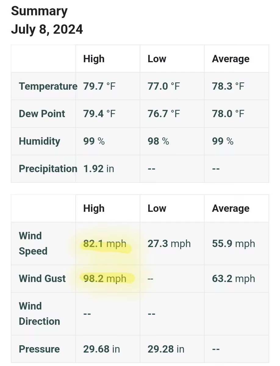
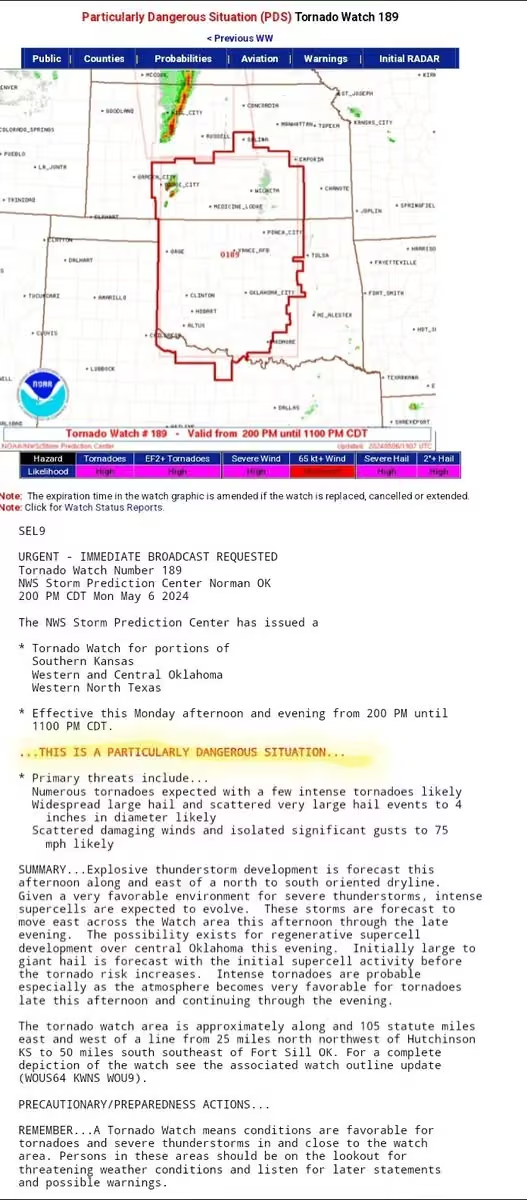
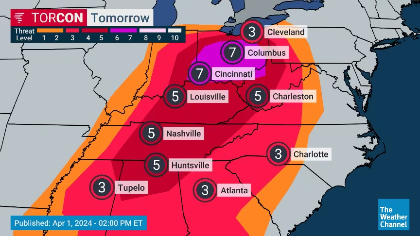
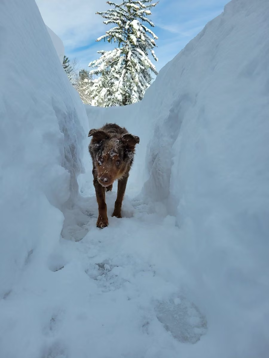
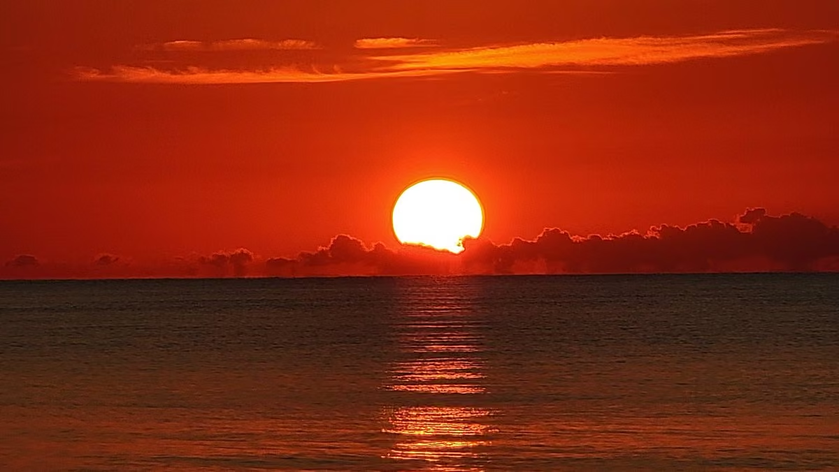
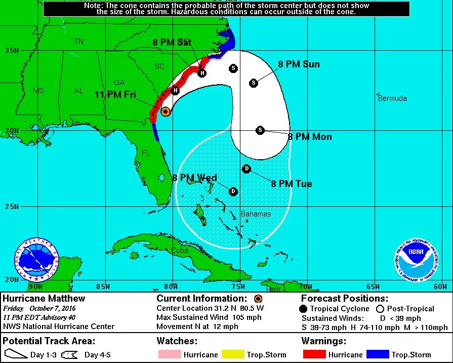
What a treat to fly this morning with Bianca on @Delta from BDL to ATL! She's the most senior flight attendant I've met with 53 years of service! That ranks her #124 out of over nearly 30 thousand FAs. Here's to many more years in the air!
#delta #flightattendant
Mike Seidel
Michael Phillip Seidel (born January 18, 1956) is an American meteorologist best known for appearing on The Weather Channel from 1992 to 2024. He is noted for his field reporting from breaking weather including severe weather, hurricanes, and snowstorms. He was live on The Weather Channel in 46 states, DC and Puerto Rico, plus Canada, Mexico, Jamaica, and Cuba and has done over 25,000 live shots. More on Wikipedia
-
Mike Seidel
@mikeseidel

-
Mike Seidel
@mikeseidel
All U.S. airports have been ground stopped by the FAA "citing extraordinary unforeseen circumstances" for safety.
www.fly.faa.gov/ois/?legacy=true -
Mike Seidel
@mikeseidel
So far 3" on the summit at Mt. Snow Ski Resort (3600') in VT. They plan to open on Nov. 21st. Coverage continues through Friday on @foxweather
@NWSAlbany -
Mike Seidel
@mikeseidel
First snowfall "fight" of the season with Courtney Difiore from Mt. Snow Ski Resort in VT as the peaks of the southern Greens, Adirondacks and Catskills pick up 4-6". We're live on @foxweather
#snow #ski #mtsnow -
Mike Seidel
@mikeseidel
The first snowfall of the season will take care of the bare ground here at Mt. Snow, VT. Live coverage starts at 8 AM ET on @foxweather.
-
Mike Seidel reposted
NCDOT NC12
@NCDOT_NC12
UPDATE: NC12 is still closed from Marc Basnight Bridge to Rodanthe, and about 800 feet of pavement has now been damaged by forces from the offshore nor'easter. Please stay safe. Avoid travel on NC12 on Pea Island. For travel updates, check drivenc.gov.
-
Mike Seidel
@mikeseidel
This is Pea Island on Highway 12 around 5 PM. An hour later it closed due to overwash. Touch and go for the next couple of days with each high tide. The mandatory evacuation for visitors continues on Hatteras/Ocracoke Islands as all ferry service remains suspended.
@NCDOT_NC12 -
Mike Seidel
@mikeseidel
Another Nor'Easter is trying to wash over Highway 12, but the dune held during the Sun PM high tide. Meanwhile homes are threatened in Rodanthe, as Buxton, which lost 20 houses to the ocean, has a new super-wide beach. We're back live Monday from the Outer Banks on @foxweather
-
Mike Seidel
@mikeseidel
We've got you covered on @foxweather as Hurricane Isaias landfalls on the Gulf Coast Friday night. Plus, we're simulcasting on @FoxNews midnight Friday - 6 AM ET Saturday.
-
Mike Seidel
@mikeseidel
In its first advisory @NHC_Atlantic is forecasting the new Tropical Depression to intensify quickly into Tropical Storm.....and then HURRICANE Isaias by Thursday. First cone has it in the northern Gulf as a Cat. 2 Friday afternoon. The latest on @foxweather
-
Mike Seidel
@mikeseidel
The last high tide of concern has passed! The water is returning to where it should be, in the canals and bays around Freeport, NY.....and other spots along the South Shore of Long Island. We're live on @foxweather.
-
Mike Seidel
@mikeseidel
The Nor'easter has moved to the Jersey Shore as weakening gets underway. What's left will get kicked out to the northeast later Monday. Coastal flood warnings end by 8 PM ET as the winds subside throughout the day. We're live on @foxweather & @FoxNews in the flood zone.
-
Mike Seidel
@mikeseidel
Nor'Easter coverage continues on @foxweather & @FoxNews as coastal flooding, beach erosion, 50 MPH gusts and heavy rain continue into Sunday.
-
Mike Seidel
@mikeseidel
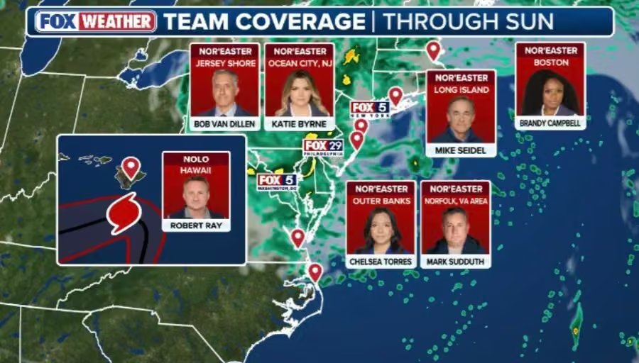
A brilliant sunset over Long Island Sound as we go with extended coverage through the weekend of the Nor'Easter and Hurricane Nolo on @foxweather
Download the app and watch for free anywhere! -
Mike Seidel
@mikeseidel
Seconds before our 6 AM ET/midnight HT live shot, a wave got us as the storm surge from Hurricane Lowell crossed the beach, seawall, the road and 2 parking lots. That's what happens when you put your back at the ocean for even a few seconds!
This media couldn't be displayed. See it on the original post. -
Mike Seidel
@mikeseidel
As Hurricane Lowell makes it's closest approach to Kauai @foxweather has live coverage starting with @thekatiebyrne at 10 PM HT/4 AM ET & I'll hit the air at midnight HT/6 AM ET. A Hurricane and High Surf Warnings are up along with a Flood Watch.
This media couldn't be displayed. See it on the original post. -
Mike Seidel
@mikeseidel
A tropical storm warning is up on Kauai as live coverage continues from Koloa on @foxweather & @FoxNews.
Hurricane Lowell makes it's closest approach Monday night and we'll show you the impacts. -
Mike Seidel
@mikeseidel
Sunrise over Poipu Beach on Kauai as we watch Category 4 Hurricane Lowell make it's turn toward Hawaii. Plus, a morning swim with the 🐢.
Live coverage continues on @foxweatherThis media couldn't be displayed. See it on the original post. -
Mike Seidel
@mikeseidel
Rainbow Falls is roaring following 15-20" of rain so far from Hurricane Lala. It's an 80' drop. Live coverage continues all night and through Sunday on @foxweather
This media couldn't be displayed. See it on the original post. -
Mike Seidel
@mikeseidel
Tropical Storm Lala is looking healthier this afternoon as @NHC_Atlantic forecasts a minimal hurricane as it approaches on Sat. It would be only the 3rd landfalling #hurricane in Hawaii in 77 years!
(Dot/Iniki)
We're live on @foxweather from Hilo with @thekatiebyrne in Honolulu. -
Mike Seidel
@mikeseidel
Check out this storm that blew-up over southern Ocean County, NJ this afternoon and kept back building until sunset. Stafford Township 5.38" & Surf City 4.36" of rain! And that nasty smoke which will hang around through Fri. Air quality alerts all/parts of 20 states
-
Mike Seidel
@mikeseidel
Montana is 🔥 🔥 🔥: Glendive 113° and Billings 110° at 3 PM MT. That's the hottest on #record in Billings, back to 1934, topping 108° on 7/14/2002.
(Death Valley is at 110°.)
#mtwx -
Mike Seidel reposted
National Hurricane Center
@NHC_Atlantic
Potential Tropical Cyclone #one Advisory 1 (10 AM CDT, Tue Jun 16): Very Heavy Rainfall and Dangerous Flash Flooding Expected from Potential Tropical Cyclone One. hurricanes.gov
-
Mike Seidel reposted
Gabe Cox 🌪️
@gabecox
Quick edit showing some of the intense moments today while documenting 8 tornadoes in northern Illinois into Indiana. Massive shoutout to @skydrama for nailing the forecast in the warm sector. Hands down the craziest tornado outbreak I've ever documented.
Full video will be released in the near future on the @thestormreel YouTube page.
#ilwx #inwx #tornado #outbreakThis media couldn't be displayed. See it on the original post. -
Mike Seidel
@mikeseidel
Benson & Stabler on the floor @TheGarden rooting on the @nyknicks
@lawandordertv -
Mike Seidel
@mikeseidel
Blinding rain continues along the MS Gulf Coast, including U.S. 90 Pass Christian to Long Beach. This rain gauge in PC is approaching 10" today!
share.google/tX5oVyKECVbNcnPdq
Flash Flood Warning 'til 945 PM CT. @foxweather
@NWSNewOrleans -
Mike Seidel
@mikeseidel
Here's Jupiter, the Moon and Venus last night as the conjunction of these planets continue into June. Tonight, Jupiter will be closer to the moon. It's worth checking out after sunset! Photo taken with my @SamsungMobile Galaxy S24 Ultra in night mode
ISO 3200 F1.7 -
Mike Seidel
@mikeseidel
50 years ago I attended my favorite 70s concert benefiting Jerry Brown's presidential campaign. The Eagles including Joe Walsh + Linda Ronstadt, Dan Fogelberg & Jackson Browne played from 8 PM - 12:50 AM. $9.75 = $57.06 today. Ticket prices have way outpaced inflation!
-
Mike Seidel
@mikeseidel
March giveth and March taketh!
Yesterday it was 86° in Washington, DC. Not only a #record high but the warmest so early in the season. Now 24 hours later it's 50°+ colder with 2" of snow on the ground in Burke, VA
📹 George Giatas
@NWS_BaltWash -
Mike Seidel reposted
Meteorologist Will Haenni WWMT
@WillWWMT
One of the more impressive tornado videos we've received in my time here. This from TJ Second in Union City. Looks like a strong, multi-vortex tornado. #miwx @wwmtnews @NWSIWX
This media couldn't be displayed. See it on the original post. -
Mike Seidel
@mikeseidel
The Blizzard rages on!
22.5" so far in Montauk with wind gusts 50 MPH+
We're live on @foxweather and @FoxNewsThis media couldn't be displayed. See it on the original post. -
Mike Seidel
@mikeseidel
Live coverage of this historic blizzard continues all night on @foxweather (and @FoxNews until 5 AM ET)
This media couldn't be displayed. See it on the original post. -
Mike Seidel
@mikeseidel
Live BLIZZARD coverage on @foxweather continues around the clock through midnight Monday. Watch us free on the app.
Simulcast on @FoxNews 11 PM tonight - 5 AM ET Monday -
Mike Seidel
@mikeseidel
#blizzard Warnings DE/NJ/NY/CT will likely be extended north to RI/MA. 1st in #nyc in 9 years (3/14/2017)
👉 1-2' Of Snow
👉 50-60 MPH Wind Gusts
👉 Coastal Flood Warnings
👉 Major To Extreme Impacts
Extended live coverage on @foxweather; free on the app!
#snowfall #winterstorm -
Mike Seidel
@mikeseidel
It looks like the Swiss Alps this morning at the @grandsuperior following 2' of snow. We're live on @foxweather
This media couldn't be displayed. See it on the original post. -
Mike Seidel
@mikeseidel
Trying to catch a snownado!
This media couldn't be displayed. See it on the original post. -
Mike Seidel
@mikeseidel
A #blizzard is raging across the North Country of MN and we're live along Lake Superior on @foxweather
#snowstorm #snow -
Mike Seidel reposted
Colin McCarthy
@US_Stormwatch
Extreme blizzard conditions on Donner Summit, California with zero visibility.
-
Mike Seidel
@mikeseidel
It's been 36 years since you could walk out on the Chesapeake Bay. And with another bitter cold weekend ahead, the ice is going nowhere.
#winter #polarvortex -
Mike Seidel
@mikeseidel
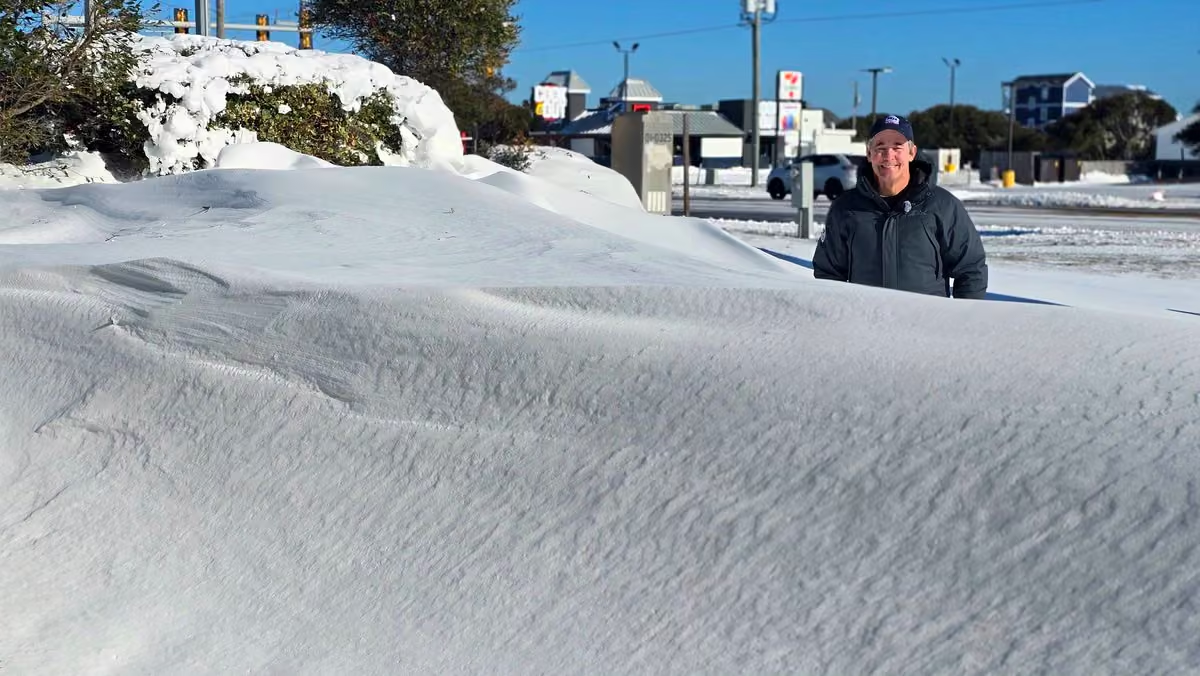
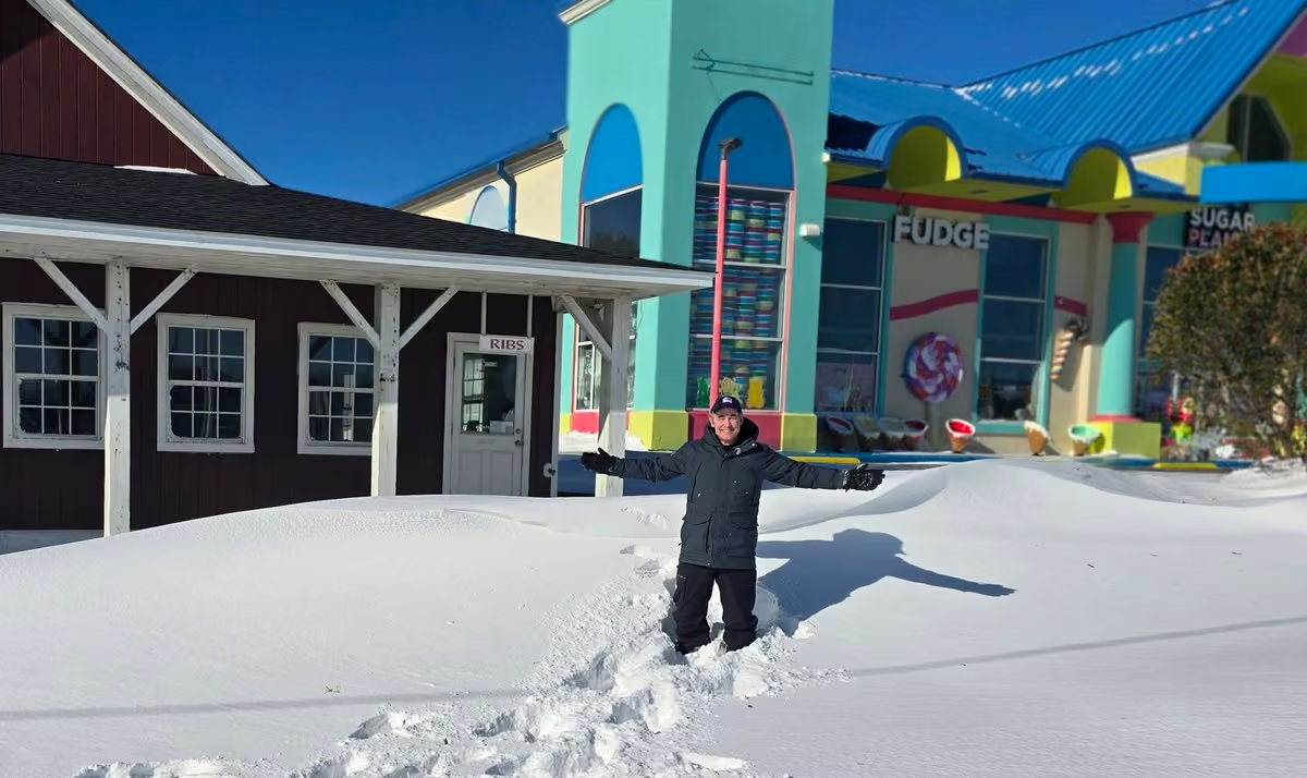
A rare sight on The Outer Banks of NC: 3-4' snow drifts! 8" of unusual powder/fluffy snow plus 50+ MPH gusts blew and shaped the snow around with ease.
Temps today creep above freezing and back to 40° Tuesday. Another Arctic shot over the weekend. We're live on @foxweather -
Mike Seidel
@mikeseidel
Storm aftermath: black ice and packed snow on Highway 158 this morning = skating rink.
Sunshine and highs today in the mid-30s will help. (still 20° below average) We're live on @foxweather
#obx #snowstorm -
Mike Seidel
@mikeseidel
Another home has collapsed in Buxton, NC. That's 17 on the Outer Banks since last September.
share.google/VowCN62FfOLNneZmu -
Mike Seidel
@mikeseidel
This pretty much sums it up this morning on the Outer Banks. Near-blizzard conditions and extreme cold with highs in the mid-20s, 30° below average.
We're live on @foxweather
#obx -
Mike Seidel
@mikeseidel
This media couldn't be displayed. See it on the original post. -
Mike Seidel
@mikeseidel
The intensity of the #snow ramped up late this afternoon as we head toward near-#blizzard conditions later this evening/overnight. We're live on the beach on @foxweather
You can watch free on the Fox Weather App!
#snowstorm -
Mike Seidel
@mikeseidel
This media couldn't be displayed. See it on the original post. -
Mike Seidel
@mikeseidel
Were back live this evening on @foxweather in near blizzard conditions!
This media couldn't be displayed. See it on the original post. -
Mike Seidel
@mikeseidel
This media couldn't be displayed. See it on the original post. -
Mike Seidel
@mikeseidel
I have 8 Delta drink vouchers that expire tomorrow night. So I followed the cart down the aisle with Catherine and Adriana and offered passengers a free drink. I was able to get rid of 6 of 8 of them. I would assume if I was flying to Vegas it would have been 8 of 8. @Delta
-
Mike Seidel
@mikeseidel
The way the wind moves the #snow down the boardwalk in Ocean City, MD reminds me of the regeneration/reformation of the T-1000 in Terminator 2. Although it's snowflakes and not "mimetic polyalloy"
Would @robertpatrickT2 agree? -
Mike Seidel
@mikeseidel
The plows are clearing up to 9.5" of snow as cars with front-wheel drive get stuck. More bitter cold with potentially another #record low max today if we stay below 18°. Monday AM down to 5° which breaks the record. Coverage continues 24/7 on @foxweather through Monday night.
-
Mike Seidel
@mikeseidel
The high today in Tulsa was 13°, a new #record low/cold max temp. and 37° below average. Winter Storm Warning through 3 PM Sunday with an additional 5-8" of snow. @foxweather is on the air 24/7 through midnight Monday with the latest on this #winterstorm
-
Mike Seidel
@mikeseidel
Live coverage continues 24/7 on @foxweather & @FoxNews as the storm spreads heavy snow and/or crippling ice across 30+ states. We're in Tulsa with a high ~10° which is 40° below average.
-
Mike Seidel
@mikeseidel
This media couldn't be displayed. See it on the original post. -
Mike Seidel
@mikeseidel
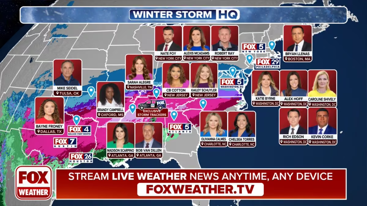
Stay with @foxweather as we have multiple crews spread out from TX to New England.
NWS Weather Prediction Center
@NWSWPC
❄️ Winter Storm Update ❄️
Here's the latest on the impending winter storm set to begin across the south-central U.S. on Friday. Confidence continues to increase for damaging ice accumulations across parts of the South. Preparations should be completed as soon as possible. -
Mike Seidel reposted
NWS Weather Prediction Center
@NWSWPC
🚨 Major Winter Storm Becoming Increasingly Likely Later This Week 🚨
Confidence has increased regarding significant snow and ice stretching from the Southern Plains on Friday to the Mid-Atlantic this weekend. Be sure to check back for the latest updates and Key Messages. -
Mike Seidel
@mikeseidel
3 hours of beautiful #snowfall across central GA (1-3")
But, with sunshine and temps. back in the 40s, "POOF", it'll be gone later this afternoon.
For some it was the first back to back winters with measurable #snow, including Pensacola, FL! -
Mike Seidel
@mikeseidel
This media couldn't be displayed. See it on the original post. -
Mike Seidel
@mikeseidel
That's @RobertRayWx on the shoreline of Lake Michigan reporting live on @foxweather
Ryan Scholl GBR (5-4) |-/
@WxScholl
Most intense lake effect snow conditions I’ve ever seen in Benton Harbor, MI right now… #miwx #wxtwitter
This media couldn't be displayed. See it on the original post. -
Mike Seidel
@mikeseidel
Check out these time lapses as the #arctic Front blew across I-95/Southern New England this morning. White outs caused by heavy #snow + wind gusts 35-45 MPH (LGA G57) as the squalls dumped a quick 1-3". The latest on the January cold/snow on @foxweather
-
Mike Seidel
@mikeseidel
Syracuse not only set a daily #snowfall record with 19.3" so far today, but it's the snowiest December day on #record and 6th overall, going back 76 years. Season to date a whopping 71.3" has piled up, 181% of average! Live coverage Wed AM on @foxweather with @thekatiebyrne
This media couldn't be displayed. See it on the original post. -
Mike Seidel
@mikeseidel
The plows have arrived on Long Beach Island as the first storm of the season dumps ~3-5" across most of NJ. We're live on @foxweather along with @thekatiebyrne in Philly and @haleymeierwx in NYC.
#snowstorm #winter -
Mike Seidel
@mikeseidel
We're fanned out across the Midwest/Northeast as the #storm brings the 1st measurable snow of the season to NYC (advisory) and Philly (warning). Live coverage continues on @foxweather
Watch for free on the app! -
Mike Seidel
@mikeseidel
Chicago picked up another 4.8" of #snow ..... with their season to date total now at 17.1" vs. the average of 3.5". This is the fastest start in 47 years and just shy of what fell all of last season: 17.6".
-
Mike Seidel
@mikeseidel
Enjoying my "late" Dec. #sunset of 529 PM!
Some locales were much earlier today:
Caribou, ME 344 PM
Coeur d'Alene, ID 356 PM
Westby, MT 400 PM
Iron Mt., MI 408 PM
Boston, MA 412 PM
Latest?
Van Horn, TX 557 PM -
Mike Seidel reposted
Jonathan Erdman
@wxjerdman
#madison, WI (11.7" at Dane Co. Reg'l Airport) just had its "heaviest pre-December in season" 2-day snowfall on record from Winter Storm #bellamy. (Previous: Nov. 8-9, 1985...10.5")
It was also Milwaukee's (Mitchell: 8") heaviest pre-December snowstorm in 30 years. #wiwx -
Mike Seidel
@mikeseidel
Not since 1968 has Des Moines seen this much #snow in a November storm. 9.9" so far ranks as the 3rd biggest November snowstorm on #record in 140 years.
And that's 70% of what fell all of last season!This media couldn't be displayed. See it on the original post. -
Mike Seidel
@mikeseidel
4 plows doing the job as moderate snow falls on Des Moines. It could be the biggest November snowstorm on record and the first double-digit #snowfall since 1968. We're live on @foxweather
This media couldn't be displayed. See it on the original post. -
Mike Seidel
@mikeseidel
This #storm has the potential to be the biggest daily snowfall in 15 years (>10.3") and even 25 years (>12.0") & a top-3 for November. We're live from Des Moines on @foxweather starting at 7 AM ET.
#winter #snow #record -
Mike Seidel reposted
NWS Eastern Region
@NWSEastern
Well we've had quiet a number of locations that saw a sighting of the 4 letter "S" word the last few days. With that here is a look at where snowfall totals stand this season so far in the East. Yes, Boston has had less snow than many areas in North Carolina.
-
Mike Seidel reposted
FOX Weather
@foxweather
❄️ WHITEOUT CONDITIONS: Heavy snow slams the Northeast causing low visibility and impacting travel. FOX Weather Storm Specialist @mikeseidel is in New York with the latest:
This media couldn't be displayed. See it on the original post. -
Mike Seidel
@mikeseidel
Eastbound on I-86 crossing into NY State. Some of these lake effect bands are impressive! We're live on @foxweather
#snow #snowfall -
Mike Seidel
@mikeseidel
This is North Redington Beach, FL just before sunset as the gusty NW winds made it look like blowing snow in the Dakotas. Tampa's forecast low Tuesday of 37° would break the #record of 40° set in 1892 and would be the coldest November temp. in 44 years.
-
Mike Seidel
@mikeseidel
Here's our drive through lake effect #snow in Erie County, PA. A Lake Effect Snow Warning is in effect until 1 PM ET Tuesday. We're live on @foxweather
#snowfall #snow -
Mike Seidel
@mikeseidel
Chicago officially (O'Hare) picked up just 1.6". But well south and east Momence, IL came in with a foot & Cedar Lake, IN checked in with 11.3".
Plus up in Kenosha, WI they measured 9.5". We'll see you live near Lake Erie starting at 2 PM on @foxweather -
Mike Seidel reposted
Kaitlyn Jesmonth
@wxkaitlynj
Thundersnow in Downtown #chicago captured by the Chicago Loop Live webcam! This was the first one around 12:23 am #ilwx ❄️⚡️@NWSChicago
-
Mike Seidel
@mikeseidel
There's nothing like the first
#snowfall of the season! It's underway here in Erie into Tuesday. But first, #chicago gets hit tonight with heavy #snow, gusty winds and possible thundersnow. @1Brandycampbell is
live on @foxweather starting at 5 AM ET from the Windy City. -
Mike Seidel
@mikeseidel
Exceptional coverage of Hurricane Melissa in Jamaica by
@RobertRayWx and Field Producer/Meteorologist
@JarrodCMaloney on @foxweather!
www.mediaite.com/media/fox-weather-earns-praise-for-inten… -
Mike Seidel
@mikeseidel
Still windy this morning across Bermuda as #hurricane Melissa is now ~450 miles north of the island. Peak wind gust was 98 MPH at the National Museum. 20% of the power outages have been restored but still 14k customers are out.
-
Mike Seidel
@mikeseidel
The worst of #hurricane Melissa is battering Bermuda.
Peak wind gusts so far:
National Museum: 98 MPH
L.F. Wade Airport: 69 MPH
14,463 BELCO customers have lost power (40% of their base) -
Mike Seidel
@mikeseidel
Final approach for #hurricane Melissa here in Bermuda. We're live on @foxweather
This media couldn't be displayed. See it on the original post. -
Mike Seidel
@mikeseidel
This reminds me of EF-4/EF-5 tornado damage.
Sir Helium
@_helium
Bluefields, Westmoreland.
-
Mike Seidel
@mikeseidel
A #hurricane Warning is now up for Bermuda ahead of Melissa. It'll be racing past the island at >40 MPH late Thursday. Today though, no issues at the beach. We're live on @foxweather from Southampton Parish.
-
Mike Seidel
@mikeseidel
Sunset over the Atlantic as we head to Bermuda to cover #hurricane Melissa. It'll be racing NE as it passes west of the island late Thursday night. Live coverage starts Wednesday morning at 9 AM ET on @foxweather
-
Mike Seidel reposted
R A W S A L E R T S
@rawsalerts
🚨#breaking: Listen as terrifying screams of extreme wind reaching 185+ mph tear through Treasure Beach, Jamaica where a catastrophic, life-threatening Category 5 hurricane is unleashing its full force. The storm's powerful eyewall is now directly over the area, battering everything in its path.
-
Mike Seidel reposted
Cody Alcorn
@CodyAlcorn
UPDATE | The group just called me from Riu Raggae in Montego Bay. They told me parts of buildings are flying past their balcony. I just got this video from them. Most of them have lost cell service 🙏
-
Mike Seidel reposted
ChaseWithHamz
@Ham_BklynWx
Intense footage from inside Black River Hospital as the eye wall of Hurricane #melissa makes landfall, causing significant damage. Footage captured by Dee Anthony.
#hurricanemelissa #jamaicaThis media couldn't be displayed. See it on the original post. -
Mike Seidel
@mikeseidel
The right eye wall hammering Jamaica:
Salty
@SevereSig
Video of damage and flooding in the Black River area from Hurricane Melissa. Video Credit - banga._.dutt / TikTok
-
Mike Seidel
@mikeseidel
Monster Melissa is about to make landfall as the 3rd strongest #hurricane on record in the Atlantic Basin, tied with the FL Keys Hurricane at 892 mb. Only Wilma (882 mb) and Gilbert (888 mb) have had a lower pressure. Live coverage from Jamaica continues on @foxweather
-
Mike Seidel
@mikeseidel
Earlier today one of the Hurricane Hunter planes had to abort and turn around because of the extreme turbulence in #hurricane Melissa
Tropical Cowboy of Danger
@FlynonymousWX
Fifth and final pass through Hurricane Melissa for our crew today. Just after noon entering from the NW corner exiting SE.
This media couldn't be displayed. See it on the original post. -
Mike Seidel
@mikeseidel
Finally, a widespread soaking #rain across parts of the SE. Atlanta had only picked up .35" since August 24th.
So far today 2.06", which will help out with the extreme drought.
It's also the coldest afternoon in over 8 months (February 23rd), with temps in the low 50s. 🥶 -
Mike Seidel
@mikeseidel
CATEGORY 5 MONSTER!
160 MPH #hurricane Melissa
Destructive wind/storm surge & catastrophic flooding will spread across Jamaica today/tonight followed by eastern Cuba. Hurricane Watches are up for central/southeastern Bahamas & Turks & Caicos.
@foxweather is live from Kingston. -
Mike Seidel
@mikeseidel
In just 18 hours Melissa has rapidly intensified from a 70 MPH Tropical Storm to a 140 MPH Cat. 4 #hurricane. Forecast to a Cat. 5 before landfall in Jamaica Tuesday AM, this will likely be their worst on record. @RobertRayWx is live from Kingston on @foxweather & @FoxNews
-
Mike Seidel
@mikeseidel
A long stretch of Bethany Beach, DE was decimated by the #noreaster, losing 6-8' of sand. There is no access to the #beach from the boardwalk. Rehoboth Beach and Fenwick Island fared much better. The storm did leave behind a lot of shells.
-
Mike Seidel
@mikeseidel
The Nor'easter is sending the angry Atlantic into the dunes on the DE beaches. We're live on @foxweather and @FoxNews through late this evening.
-
Mike Seidel
@mikeseidel
Stay with @foxweather & @FoxNews for the latest on the first Nor'easter of the season, with impacts from the Carolinas to New England.
#storm #noreaster -
Mike Seidel
@mikeseidel
Looking forward to your questions today about weather and storm coverage over the past 30 years. I hope you can join Bryan and me at 4 PM ET!
-
Mike Seidel
@mikeseidel
An 8th home has just collapsed into the Atlantic in Buxton, NC. @thekatiebyrne is there on @foxweather
#tropicswxThis media couldn't be displayed. See it on the original post. -
Mike Seidel
@mikeseidel
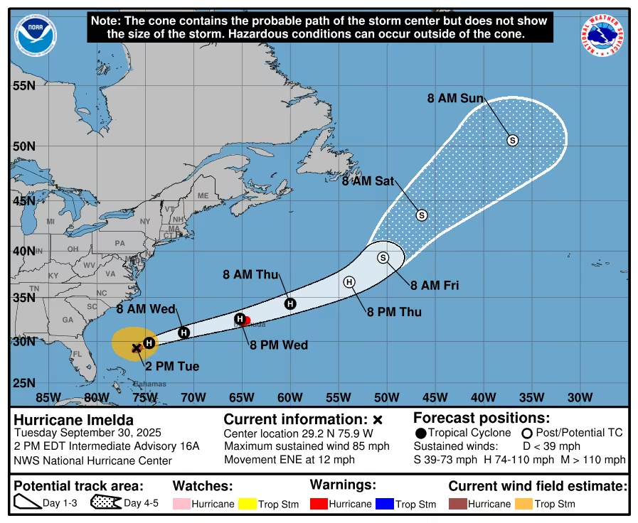
Increasing wind and surf across Bermuda as Hurricanes #humberto & #imelda approach. Bermuda could take a direct hit from Imelda later Wednesday. @haleymeierwx is live on @foxweather from the island.
#tropics -
Mike Seidel
@mikeseidel
4 HOUSES DOWN IN BUXTON, NC
Video: @IslandFreePress
islandfreepress.org/outer-banks-news/four-oceanfront-home… -
Mike Seidel
@mikeseidel
It's the first time I've seen an entire primary #rainbow from the runway. (@iflyCHS) Then to follow it up with this #sunset from the air was an added extra on my trip back on @Delta 💯
-
Mike Seidel reposted
Colin McCarthy
@US_Stormwatch
Unbelievable satellite imagery of the dual tropical cyclones off the East Coast of the US, Major Hurricane Humberto and Imelda.
Imelda’s cloud shield stretches over 1,400 miles, covering nearly the entire East Coast. -
Mike Seidel reposted
FOX Weather
@foxweather
🌀HURRICANE HQ: FOX Weather Storm Specialist @mikeseidel is on the sand in Folly Beach, South Carolina, tracking the impacts of Hurricane Humberto and Tropical Storm Imelda, including the risk of life-threatening rip currents.
This media couldn't be displayed. See it on the original post. -
Mike Seidel reposted
National Hurricane Center
@NHC_Atlantic
Tropical Storm #imelda Advisory 8A: Depression Becomes Tropical Storm Imelda. Tropical Storm Conditions Expected Over the Central and Northwestern Bahamas This Afternoon and Evening. hurricanes.gov
-
Mike Seidel
@mikeseidel
Back live on @foxweather as the #surfers make the best of these ~3 footers.
Ahead: 8-12' waves via Humberto/Imelda.
The future Tropical Storm Imelda is 675 miles SSE of Folly Beach & forecast to make its closest approach (265 miles) on Tuesday. The #1 impact: rainThis media couldn't be displayed. See it on the original post. -
Mike Seidel
@mikeseidel
We now have Tropical Depression #9, soon to become Imelda. Here's the latest forecast from @NHC_Atlantic showing the continuing trend of it staying offshore. 👍
But there will still be impacts!
We're live on @foxweather
#tropicswx #hurricane -
Mike Seidel reposted
National Hurricane Center
@NHC_Atlantic
NHC will initiate advisories on Potential Tropical Cyclone Nine (formerly AL94), located near eastern Cuba, at 500 PM EDT (2100 UTC).
-
Mike Seidel reposted
National Hurricane Center
@NHC_Atlantic
2 pm EDT - A low pressure system #94l appears to be forming near eastern Cuba and the southeastern
Bahamas. Gradual development of this system is expected, and it will likely become a tropical
depression during the next day or so while it moves across the central and northwestern Bahamas. Tropical storm watches or warnings could be required for portions of the Bahamas and advisories on a potential tropical cyclone could be issued as early as later today. Visit hurricanes.gov for more. -
Mike Seidel
@mikeseidel
FINALLY!
For the first time in a month IT RAINED! A shower blew up and dumped .65" in 17 minutes. A cold front will bring more up and down the East Coast through Friday. Get the latest on @foxweather -
Mike Seidel reposted
National Hurricane Center
@NHC_Atlantic
NHC will initiate advisories on Tropical Storm Fernand, located in the southwestern Atlantic, at 500 PM EDT (2100 UTC).
-
Mike Seidel
@mikeseidel
Highway 12 is Re-Opening!
NCDOT NC12
@NCDOT_NC12
Dare County is starting a phased re-entry for Hatteras Island starting at Noon TODAY! At noon, residents, property owners, and workers can access NC12 at the Basnight Bridge. At 5 a.m. Sunday, visitors will also be allowed entry.
Details here: www.darenc.gov/Home/Components/News/News/9185/17 -
Mike Seidel
@mikeseidel
Good morning from Kitty Hawk!
#sunrise with the surf crashing as we re-cap the impacts from #hurricane Erin on @foxweather -
Mike Seidel
@mikeseidel
10-15' waves breaking offshore and rolling over the beaches on The Outer Banks. So far so good as this morning's high tide didn't breach the dunes here. We're live of @foxweather & @FoxNews
#hurricaneerin #tropicalThis media couldn't be displayed. See it on the original post. -
Mike Seidel
@mikeseidel
Check out Waylon Kirkley from Wilmington, NC catching a massive wave and riding it to the beach here in Nag's Head, NC. Our live coverage of #hurricaneerin from SC, NC, MD, NJ and NY continues on @foxweather
#surfing #tropics -
Mike Seidel
@mikeseidel
Will these homes survive #hurricaneerin? With 15-20' waves forecast, these abandoned houses in Rodanthe, NC could be taken out later this week. Live coverage on @foxweather starts at 7 AM ET with @thekatiebyrne from Jacksonville Beach, FL
#obx #tropical -
Mike Seidel reposted
National Hurricane Center
@NHC_Atlantic
Hurricane #erin Advisory 17: Erin Becomes the First Hurricane of the 2025 Season. Expected to Pass Near Or North of the Leeward Islands On Saturday. hurricanes.gov
-
Mike Seidel
@mikeseidel
We'll keep you updated on @foxweather!
Dr. Levi Cowan
@TropicalTidbits
Tropical Storm #erin has formed in the far eastern Atlantic, expected to track generally westward and intensify over the next 5 days. Intensification is likely to be slow at first due to Erin moving over currently cool sea surface temperatures, followed by strengthening into a hurricane once Erin tracks farther west over warmer waters later this week.
Computer models are in good agreement that Erin will likely pass north of the Leeward Islands of the eastern Caribbean this weekend, though the region should monitor the forecast for any southward shifts this week.
It is too early to be confident in Erin's long-term future beyond this weekend. Current indications favor an ultimate turn northward over the western Atlantic, avoiding North America, but this portion of Erin's track is not yet certain. We are now in the peak of the hurricane season, so it is wise to have a hurricane plan ready to activate in case Erin or any other storm comes your way. -
Mike Seidel
@mikeseidel
Milwaukee had their 2nd wettest day on #record (since 1871) on Saturday with 5.74" of rain, and it all fell after 7 PM CT, resulting in water rescues and evacuations.
Storm total through 5 AM CT:
6.69"
#flooding #wiwx -
Mike Seidel
@mikeseidel
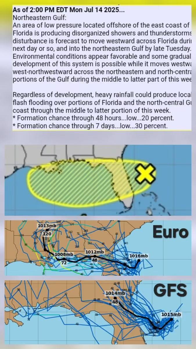
Here we go: Invest #97l could become the season's first #hurricane by this time next week. (Average date is August 11th.) Here are the GFS/Euro Ensembles' 10-day forecast tracks. We have a lot of time to watch this one, but remember always be prepared!
Stay with @foxweather -
Mike Seidel reposted
NWS Phoenix
@NWSPhoenix
Phoenix Sky Harbor hit 118°F at 3:37 PM this afternoon, which sets a new record hottest temperature for August. Phoenix records date back to 1895. Temperatures are still bouncing between 116-118°F at this time. #azwx
-
Mike Seidel
@mikeseidel
It can only happen on a cloudy day with an east wind in the summer. The high today in #atlanta of 69° was not only a #record low max temp, but the "coldest" so early in the season and the 1st time since 1917 the temp didn't crack 70° the first 2 weeks of August .
-
Mike Seidel
@mikeseidel
UPDATE: I'm pleased to announce that I'll be contributing to another year of storm coverage on @foxweather and @FoxNews!
Make sure you download the FOX Weather app on your phone so you can watch for free...anytime, anywhere. And as always, thanks for your support!
Mike -
Mike Seidel
@mikeseidel
Good morning from #stlouis ahead of another steamy day.
We're live on @foxweather talking heat, storms and a bonafide COLD FRONT! 👍 -
Mike Seidel
@mikeseidel
A couple of storms rapidly developed in the past hour south and west of #stlouis, providing brief relief from mid-90s and heat indices ~110°. Better #storm chances later Wednesday with the approaching cold front. We'll see you live on @foxweather!
-
Mike Seidel
@mikeseidel
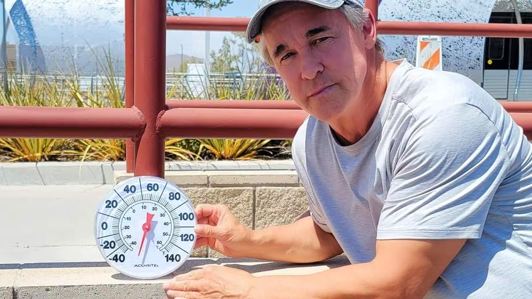
Check out the surface temps on the deck at @saltandsmokebbq in #stlouis 🔥
This media couldn't be displayed. See it on the original post. -
Mike Seidel
@mikeseidel
The first batch of thunderstorms courtesy of Invest 93L soaked the MS Gulf Coast this evening with @81trwKeeslerAFB picking up 1.18" 6-7 PM CT. Some PWSs had over 2". Live coverage continues Thursday from LA on @foxweather
-
Mike Seidel
@mikeseidel
#sunrise over Biloxi as we watch for potential development of Invest 93L in the Gulf as @NWSNHC puts the odds at 40% as of 8 AM ET. Stay with @foxweather for updates and more live coverage.
-
Mike Seidel
@mikeseidel
We have Invest 93L in the Atlantic and the 12Z Euro & GFS Ensembles have different thoughts on its future. Will we get Dexter? Stay tuned to @foxweather for updates and more live coverage.
-
Mike Seidel
@mikeseidel
We're live covering #tropicalstorm Chantal on @foxweather & @FoxNews
This media couldn't be displayed. See it on the original post. -
Mike Seidel reposted
National Hurricane Center
@NHC_Atlantic
Tropical Storm #chantal has formed off the southeast U.S. coast. Tropical storm warning issued for portions of the Carolinas, and tropical storm conditions are expected to begin in that area later today. Latest forecast and hazard info can be found at hurricanes.gov
-
Mike Seidel
@mikeseidel
Sunrise over Folly Beach as we continue our live coverage of Tropical Depression #3 on @foxweather
It's forecast to become #tropical Storm Chantal before landfall.
#hurricaneseason #scwx -
Mike Seidel reposted
National Hurricane Center
@NHC_Atlantic
NHC will initiate advisories on Tropical Depression Three, located in the Atlantic Ocean offshore of the southeastern United States, at 500 PM EDT (2100 UTC).
-
Mike Seidel reposted
National Hurricane Center
@NHC_Atlantic
2 pm EDT - Satellite data indicate that the system located about 150 miles off the northeast Florida coast has become better defined today with an area of strong winds located on its east side. A short-lived subtropical or tropical depression could form later today or on Saturday. This low is expected to move inland over the southeastern U.S. by early Sunday. An Air Force Reserve Hurricane Hunter aircraft is currently en route. hurricanes.gov
-
Mike Seidel
@mikeseidel
We continue to watch an area of storms off the SE Coast which has a 60% chance of becoming a tropical/subtropical depression. The @53rdWRS will take a look at it this afternoon. We're live on @foxweather with the latest on impacts
-
Mike Seidel
@mikeseidel
We continue to follow the likelihood of #tropical development off the SE Coast later this weekend or early next week:
www.nhc.noaa.gov/gtwo.php?basin=atlc&basin=atlc&fdays=2
Stay tuned to @foxweather for the latest. -
Mike Seidel
@mikeseidel
A gusty squall with over a dozen lightning bolts hit the beach just before 630 AM.
(peak gust of 31 MPH) Rainfall totals since midnight have topped 2" in Pinellas County.
And @NWSNHC has increased odds on tropical development to 60%. We're live on @foxweather -
Mike Seidel
@mikeseidel
We're keeping an eye on the #tropics as we await further updates from @NWSNHC.
We're live on @foxweather
#hurricaneseasonThis media couldn't be displayed. See it on the original post. -
Mike Seidel reposted
National Weather Service
@NWS
Over the past 3 days of this eastern U.S. heat wave, hundreds of record highs have been broken from the Plains to the East Coast. Many more are possible today, before a cold front, and showers and storms start to back down the extreme heat.
weather.gov/heat -
Mike Seidel reposted
NWS Storm Prediction Center
@NWSSPC
12:02pm CDT #spc_watch WW 434 TORNADO IL IN MI LM 181700Z - 190000Z, #ilwx #inwx #miwx #lmwx, www.spc.noaa.gov/products/watch/ww0434.html
-
Mike Seidel
@mikeseidel
Good morning from #chicago on what could be their 3rd 90°-day this season. We're staying cool at the beach ahead of the severe #storm threat on Wednesday. Catch us today on @foxweather
-
Mike Seidel
@mikeseidel
Smoke from deadly Canadian wildfires has spread 3000 miles SE, all the way to the Atlantic, with air quality in parts of the Dakotas very unhealthy to hazardous.
archive.ph/2025.05.31-181251/https://www.nytimes.com/arti… -
Mike Seidel
@mikeseidel
"FROG STRANGLER"
A cold front ends this 7-day stretch of rain in north GA. My gauge: 4.35" (19 hours and 51 minutes) since last Saturday and 8.03" in May.
@1Brandycampbell has the latest on the severe threat in parts of GA/SC/NC on @foxweather -
Mike Seidel
@mikeseidel
Just before high tide tonight in Scituate, MA as the waves crash against the sea wall.
This media couldn't be displayed. See it on the original post. -
Mike Seidel
@mikeseidel
As a Nor'Easter bears down on New England, winds have gusted to 50 MPH with a cold, lashing rain. Temps. In the mid-40s with a wind chill of 40° is the coldest weather I've covered this late in the spring.
We await the 8 PM ET high tide.
We're live on @foxweather -
Mike Seidel
@mikeseidel
A late-season Nor'Easter hits Thursday. Live coverage continues on @foxweather
This media couldn't be displayed. See it on the original post. -
Mike Seidel
@mikeseidel
~80° as the Easter Bonnet Bar Crawl gets underway in Rehoboth Beach, DE. And despite a water temp of 50° a few have ventured into the surf. I'll wait! #happyeaster2025
@foxweather -
Mike Seidel
@mikeseidel
How about waking up to 5.5" of #snow on April 12th? Meteorologist Rick DiMaio grabbed these in Twin Lakes, PA (1450'). Snow fell across the Poconos and Catskills.
#1: 5.8" in Austerlitz, NY
@foxweather -
Mike Seidel
@mikeseidel
Nobody was home as this house burned near our location close to the Saline River in Benton. The river has crested & will drop back below #flood stage tonight. Little Rock picked up 11.82", their 3rd wettest 4-day period in 150 years. We're live on @foxweather & @FoxNews
-
Mike Seidel
@mikeseidel
Watch as a severe #storm hammers metro Little Rock with bolts of lightning and gusts to 69 MPH.
This media couldn't be displayed. See it on the original post. -
Mike Seidel
@mikeseidel
Flash flooding continues across parts of AR, TN, KY, IL and MO with most of the #flood watches through 7 AM CT Sunday. Remember to "turn around, don't drown."
We're live on @foxweather & @FoxNews just north of Little Rock.
@NWSLittleRock -
Mike Seidel
@mikeseidel
Check out this wall cloud from a #tornado-warned storm that moved just east of the @LITAirport followed by very heavy rain (.24" in 4 minutes) and a 41 MPH gust.
Tornado Watch continues until 4 AM CT with a threat of more twisters on Saturday.
@NWSLittleRock -
Mike Seidel reposted
FOX Weather
@foxweather
FOX Weather Exclusive Storm Chaser Brandon Copic brings the latest unhinged footage out of Arkansas as we cover the powerful tornado outbreak this evening.
FOX Weather is live with extended coverage as we continue to track the severe storms.
#tornado #arkansas #foxweather -
Mike Seidel reposted
FOX Weather
@foxweather
LIVE ON FOX WEATHER: A very large and dangerous tornado just crossed the road right in front of FOX Weather Exclusive Storm Tracker @BrandonCopicWx
Download the FOX Weather app to watch live video. -
Mike Seidel
@mikeseidel
Severe storms hammering metro Atlanta with an earlier #tornado warning west of @ATLairport. Ground stop there until at least 1:45 PM ET.
Watch until 7 PM ET:
www.spc.noaa.gov/products/watch/ww0087.html
@foxweather has the latest. -
Mike Seidel
@mikeseidel
***RECORD POLLEN COUNT***
14,801 (grains per cubic meter) is the highest in 35 years of record keeping in Atlanta and smashes 9368 in March, 2012.
Rain & Thunderstorms Sunday-Monday will cleanse the air but create green sludge in the streets.
www.atlantaallergy.com/pollen_counts -
Mike Seidel
@mikeseidel
Springfield kicked off officially at 5:01 AM ET. It was very mild east of the cold front with 65° in Buffalo and 70° in Mobile. The season gets underway with a warmer than average day in the NE but below normal temps and much colder than yesterday across parts of the South.
-
Mike Seidel reposted
NWS Storm Prediction Center
@NWSSPC
⚠️❗️A Particularly Dangerous Situation Tornado Watch is now in effect for much of MS and northern LA until 6 pm CDT
Numerous strong long-track tornadoes are likely, along with very large hail and damaging winds
Stay weather aware for critical info see www.spc.noaa.gov -
Mike Seidel
@mikeseidel
From record highs in the 60s/70s Friday afternoon to teens and wind chills ~0° with #snow and blowing snow this morning. #blizzard, Winter Storm and High Wind Warnings until 7 PM CT. We're live on @foxweather & @FoxNews
-
Mike Seidel
@mikeseidel
DANGEROUS WEATHER SATURDAY!
"Numerous significant tornadoes, some of which should be long-track and potentially violent"
This is only the 3rd time that @NWSSPC has issued a high risk for severe weather the day before.
www.spc.noaa.gov/products/outlook/day2otlk.html
Stay with @foxweather -
Mike Seidel
@mikeseidel
WEATHER WHIPLASH in Fargo: Record highs today ~70° then temps crash 50° with near #blizzard conditions Saturday AM. We're live on @foxweather
-
Mike Seidel
@mikeseidel
I can't remember ever seeing a relative humidity this low in metro #atlanta. At 6 PM it was 12% at Dobbins Air Reserve Base 🌵.
The lowest I found in GA was 9% in Blairsville: 53°/Td -5°.
High 🔥 danger continues through Monday.
forecast.weather.gov/data/obhistory/KMGE.html -
Mike Seidel reposted
NWS Storm Prediction Center
@NWSSPC
Stay weather aware early next week as an active pattern is expected. Here are our key messages for next Tuesday and Wednesday.
-
Mike Seidel
@mikeseidel
Layoffs underway at NOAA/NWS
www.axios.com/2025/02/27/layoffs-hit-noaa-national-weathe… -
Mike Seidel
@mikeseidel
It's not the Sierra, but Croatan Beach, VA! My good friend Patrick McLaughlin shared these impressive photos of Wednesday's storm with decent drifts. He measured 10". Officially, Norfolk picked up 10.2", their 8th snowiest day since 1890. Seasonal average is 6.2".
-
Mike Seidel
@mikeseidel
The biggest storm and coldest weather so far this winter. We're live on @foxweather
This media couldn't be displayed. See it on the original post. -
Mike Seidel
@mikeseidel
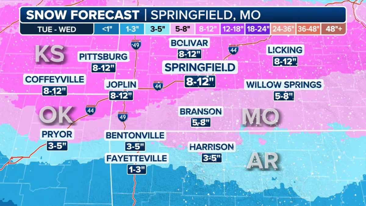
Big change since mid-morning with the temp dropping to 11° & the wind chill down to -8° in Springfield with moderate to heavy #snow. 8-12" forecast then #record cold high temps in the mid-teens Wed-Thu. (average high is 50°)
We're live on @foxweather -
Mike Seidel
@mikeseidel
BIGGEST #storm & COLDEST temps of the season on the way to Springfield.
2024-25:
Biggest: 6.3" 1/9-10
Coldest: 1° 1/21
Last 12" daily snowfall: 12/13/2000
Last 12" #snowstorm:
11/30 - 12/1/2006
Highs Wed (13°) & Thu (16°) will set record low maxes. Wind chills down to -20°. -
Mike Seidel
@mikeseidel
Live coverage continues on @foxweather for the next storm. #snow/sleet/ice will spread from the Plains and Midwest into the Northeast.
You can watch for FREE on the FOX Weather app.
#winter #storm -
Mike Seidel
@mikeseidel
Washington (DCA) picked up 5.9" of #snow on Tuesday, bringing their seasonal total to 14.3". (4" fell in 4 hours between 4 and 8 PM.) This surpasses their 30-year average of 13.7" for the first time in 6 years.
-
Mike Seidel
@mikeseidel
Who let the dogs out?!?!
What a perfect morning in Boston Common!
@foxweather
#dog #dogday #dogloversThis media couldn't be displayed. See it on the original post. -
Mike Seidel
@mikeseidel
A solid 4" of #snow fell in Boston Common overnight. We're live on @foxweather as we watch the next 3 snowstorms in the pipeline over the next week!
#snowstorm #winter -
Mike Seidel
@mikeseidel
As of 3 PM CT, I-10 EB and WB are now open from Louisiana/Texas state line to I-49.
This includes the stretch through Lafayette, Baton Rouge and New Orleans.
Thanks to @myARDOT
for lending their snow plows to help out @La_DOTD !
Here's one this morning in BTR -
Mike Seidel
@mikeseidel
#sunrise over Baton Rouge ahead of a warmer day. Yesterday's high was 38° with 5 hours above freezing. Today up to 48° and a forecasted 11 hours above freezing. The main roads are in pretty good shape. Just waiting for I-10 to open! We're live on @foxweather
-
Mike Seidel
@mikeseidel
This is I-110 in Baton Rouge at 3 PM. Is it going to get plowed or is the @La_DOTD waiting for the #snow to melt? A short time later I saw this pushing the snow off the I-10 East overpass over College Drive. Here's the list of LA road closures:
wwwapps.dotd.la.gov/administration/announcements/announce… -
Mike Seidel
@mikeseidel
As the sun comes up, it's illuminating the historic footprint of #snow from Tuesday's storm, including 10"+ in LA and Florida's biggest #snowstorm in Milton with 8.8".
-
Mike Seidel
@mikeseidel
This is not an AI generated nightmare! It's Baton Rouge where it's 7°, their coldest Jan. AM on #record (back to 1892) following Tuesday's unofficial biggest daily #snowfall of 7.6" on record. This "skating rink" will be slow to melt today. We're live all @foxweather
-
Mike Seidel
@mikeseidel
Unofficially it's the biggest daily snowfall in Baton Rouge since 1914, with 4" and counting!
(#1: 6.5" 2/15/1895)This media couldn't be displayed. See it on the original post. -
Mike Seidel
@mikeseidel
First ever #blizzardwarning for parts of LA! Stay with @foxweather for live coverage from TX to SC.
This media couldn't be displayed. See it on the original post. -
Mike Seidel
@mikeseidel
A complete rundown of the forecast and the impacts from Tuesday's storm, including the road temps on different sides of the street.
@foxweatherThis media couldn't be displayed. See it on the original post. -
Mike Seidel
@mikeseidel
Our team of meteorologists are out covering this highly unusual/impactful I-10 #winterstorm and the Arctic cold. From Houston to New Orleans to Pensacola Beach this could be a once in a generation event. Live coverage continues on @foxweather
#snow -
Mike Seidel
@mikeseidel
Check out the footprint of this winter storm.....pink are warnings: www.weather.gov
The latest on @foxweatherThis media couldn't be displayed. See it on the original post. -
Mike Seidel reposted
The Associated Press
@AP
BREAKING: The Pacific Palisades fire is now the most destructive in Los Angeles city history, with an estimated 1,000 structures destroyed.
Follow AP's live coverage. apnews.com/live/live-updates-wildfire-los-angeles-palisad… -
Mike Seidel
@mikeseidel
Stay with @foxweather for the latest!
This media couldn't be displayed. See it on the original post. -
Mike Seidel
@mikeseidel
We're previewing the winter storm that will drape the south with snow and ice, from Dallas to Atlanta. A Winter Storm Warning kicks in Thursday AM across north TX. We've got you covered on @foxweather with live coverage and the latest forecast.
-
Mike Seidel
@mikeseidel
This was my late afternoon drive down U.S. 61 to St. Louis. I had to keep it under 40 and let this semi pass. The Winter Storm Warning runs until 6 AM CT with another 3-5" of #snow.
Lookout Baltimore, DC and Philly: you're next in line!
@foxweather -
Mike Seidel
@mikeseidel
The storm is ramping up NW of St. Louis with heavy snow and wind gusts >30 MPH into late tonight. And it's all headed east to Baltimore/DC/Philly.
We're live with the latest on @foxweather and @FoxNews -
Mike Seidel
@mikeseidel
We're underway in St. Louis as a major winter storm will impact 15 states from KS to the Jersey Shore with 60 million in its path......up to a foot of snow and potentially crippling ice. Extended coverage all weekend on @foxweather
-
Mike Seidel
@mikeseidel
Severe storms rolled through north GA earlier.....the sun is back the rest of the week with 60s through Tue. But the future is much colder. The 00Z Euro = #polarvortex in 10 days.
But the Euro Ensemble Mean & GFS aren't nearly that cold. Stay tuned to @foxweather for updates. -
Mike Seidel
@mikeseidel
Much needed rain/thunder are drenching a mild (66°) metro #atlanta with forecast storm totals 1.5-2". Since Oct. 1st only 2.54" has fallen, a deficit of 4.72".
Cold front blows through overnight, then sunny/windy on Wednesday and mid-40s. -
Mike Seidel
@mikeseidel
It's Day #4 of the #lakeeffect #snow Warning. We're live from Mayville, NY on @foxweather and @FoxNews
This media couldn't be displayed. See it on the original post. -
Mike Seidel
@mikeseidel
Incredible! #lakeeffect Day #3 and we picked up an additional 6" since 5 AM. Storm totals in the area >3.5 feet with another foot (or more) through Monday across western Chautauqua County, NY.
#snow #nywx -
Mike Seidel
@mikeseidel
As this lake band breaks up a bit of sunshine between the heavier periods of #snow. 46" in Barnes Corner & Copenhagen (off Ontario) & 37.7" in Cassadaga (off Erie).
GOOD NEWS: I-90 open except for commercial vehicles. We're live on @foxweather and @FoxNews -
Mike Seidel
@mikeseidel
Trying to drive the @NYSThruway tonight between Buffalo and Erie?
Fuggedaboutit!This media couldn't be displayed. See it on the original post. -
Mike Seidel
@mikeseidel
Day #2 of #lakeeffect #snow and this morning we're reporting from Fredonia, NY on @foxweather and @FoxNews
This media couldn't be displayed. See it on the original post. -
Mike Seidel
@mikeseidel
This was our 20-mile drive from Mayville to Fredonia, NY which took about an hour. Mayville at 30" of #snow as of 5:30 AM. We're live on @foxweather and @FoxNews
#lakeeffect #snowstorm -
Mike Seidel
@mikeseidel
Another heavy band of #lakeeffect #snow has pushed the total in Mayville, NY to 17". We're live on @foxweather and @FoxNews
-
Mike Seidel
@mikeseidel
2" in the past hour with 11" on the ground in Mayville, NY. We're live on @foxweather and @FoxNews
This media couldn't be displayed. See it on the original post. -
Mike Seidel
@mikeseidel
8" of #snow in 7 hours here in Mayville, NY. By Monday there could be 4 feet on the ground. We're live on @foxweather & @FoxNews through the day.
#lakeeffect #snowstorm -
Mike Seidel
@mikeseidel
FEET OF SNOW as the season's first lake effect clobbers the snowbelts in NY. #snowfall rates of 2"+/hour & possible thundersnow. Plus, a potential impact at the @BuffaloBills game Sunday night. We'll show it to you live starting Friday AM on @foxweather
#snow -
Mike Seidel reposted
NOAA
@NOAA
(2/2) View/download our 2024 Atlantic #hurricaneseason satellite video + images at:
www.noaa.gov/news-release/atlantic-hurricane-season-races…
#weatherreadynation @NWSThis media couldn't be displayed. See it on the original post. -
Mike Seidel
@mikeseidel
We could have a new NJ state snowfall #record for November! The current record is 17.5" in Dover, NJ November 25-26, 1938.
Thanks to @gdimeweather & @SDBrownWX for the research.
Here are the rest of the reports:
www.weather.gov/source/crh/snowmap.html
#snow #snowstorm #njwx
@NWS_MountHolly -
Mike Seidel
@mikeseidel
8-10" of #snow has fallen so far across the Poconos and Catskills. We're live on @foxweather.
This media couldn't be displayed. See it on the original post. -
Mike Seidel
@mikeseidel
The #snow intensity is picking up, but overnight - early Friday AM snowfall rates will increase to at least an inch an hour as the upper low swings across the area. Up to a foot in the higher spots with a Winter Storm Warning until 4 PM Friday. The latest on @foxweather
-
Mike Seidel
@mikeseidel
A bunch of happy kids as the #snow starts to stick across the Poconos. Coverage continues on @foxweather
#winteraheadThis media couldn't be displayed. See it on the original post. -
Mike Seidel
@mikeseidel
The #snow is underway across the Poconos, but roads including I-380 are just wet. Tonight, temps drop to and below freezing along with ~foot of snow across the higher spots of NE PA/Southern Tier of NY. Winter Storm Warning until 4 PM Friday. We're live on @foxweather
-
Mike Seidel
@mikeseidel
The @NWSBinghamton mets have issued their 1st Winter Storm Warning of the season.
L to R: Lead Mets Mike Murphy and Mike Kistner & Forecaster Ema Sera
The higher elevations could pick up a foot of #snow. We're live from Scranton on @foxweather -
Mike Seidel
@mikeseidel
Miami & Ft. Lauderdale have ended record stretches of 70° or warmer at 203 and 214 days, respectively. The coolest air mass so far will sweep across FL and end the stretch short of their record in Key West of 240 days. Temps Fri AM drop into the 50s in SOFL & 60s in the Keys.
-
Mike Seidel
@mikeseidel
Tropical Storm Sara has formed and will dump 5-10"+ of rain across parts of Central America. But this land interaction will tear the storm apart & recent model runs NO LONGER forecast a significant impact in FL. Let's see if this changes. Stay tuned to @foxweather
#tropics -
Mike Seidel
@mikeseidel
It's a wait and see as far as any impacts in the Eastern Gulf/Florida next week. The 2-day trend is a track farther west into Mexico. How much does the land impact the storm and what's left after that on ~Tuesday? Uncertainty is high!
Updates on @foxweather
#tropical -
Mike Seidel
@mikeseidel
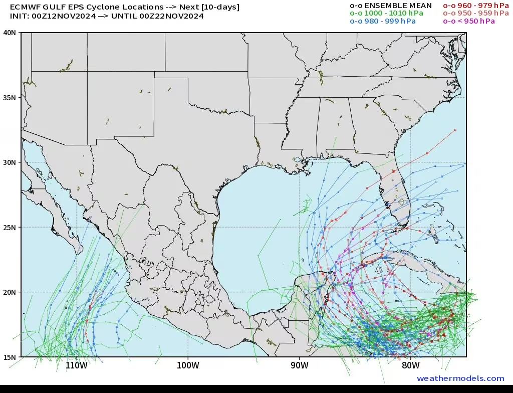
Invest 99L is forecast to become Tropical Storm Sara by/over the weekend as it wanders in the western Caribbean. Next week it could enter the Gulf Of Mexico. Beyond that, we'll see it the jet stream steers it to FL.
Stay with @foxweather
#tropicswx #hurricaneseason2024 -
Mike Seidel
@mikeseidel
It finally rained (officially) today in Atlanta for the first time in 6 weeks (.07"), the 2nd longest dry stretch on #record. Those clouds shrouded my jog up Kennesaw Mt. During the past 100 days, 84% of the rain (11.12") fell on just 3 days with Helene in Sept.
-
Mike Seidel
@mikeseidel
The sun is shining in Denver following their BIGGEST November snowstorm in 33 years: 20.0" fell Tue-Sat! Some spots in Elbert and Lincoln Counties picked up 41.5". Find your location:
mesonet.agron.iastate.edu/wx/afos/p.php?pil=PNSBOU&e=2024…
55° this afternoon = rapidly improving roads
#snowstorm
@foxweather -
Mike Seidel reposted
Jon Nese
@jmnese
Many thanks to @psumeteo alum @mikeseidel for stopping by Meteo 201 bright and early this morning. Always good to hear his insights about the broadcast meteorology business.
-
Mike Seidel
@mikeseidel
Tropical Depression 18 forecast to intensify to #hurricane Rafael by midweek. Late week it encounters wind shear/drier air/cooler water temps which will weaken it, but impacts are still possible along the Gulf Coast. @foxweather has the latest.
#tropics -
Mike Seidel
@mikeseidel
Potential Tropical Cyclone #12 is forecast to become Tropical Storm Rafael by Monday. #hurricane Watch for the Caymans. There could be impacts along the Gulf Coast later this week. Stay with @foxweather for updates.
LATEST ADVISORY:
www.nhc.noaa.gov/text/refresh/MIATCPAT3+shtml/032054.shtml
#tropics -
Mike Seidel
@mikeseidel
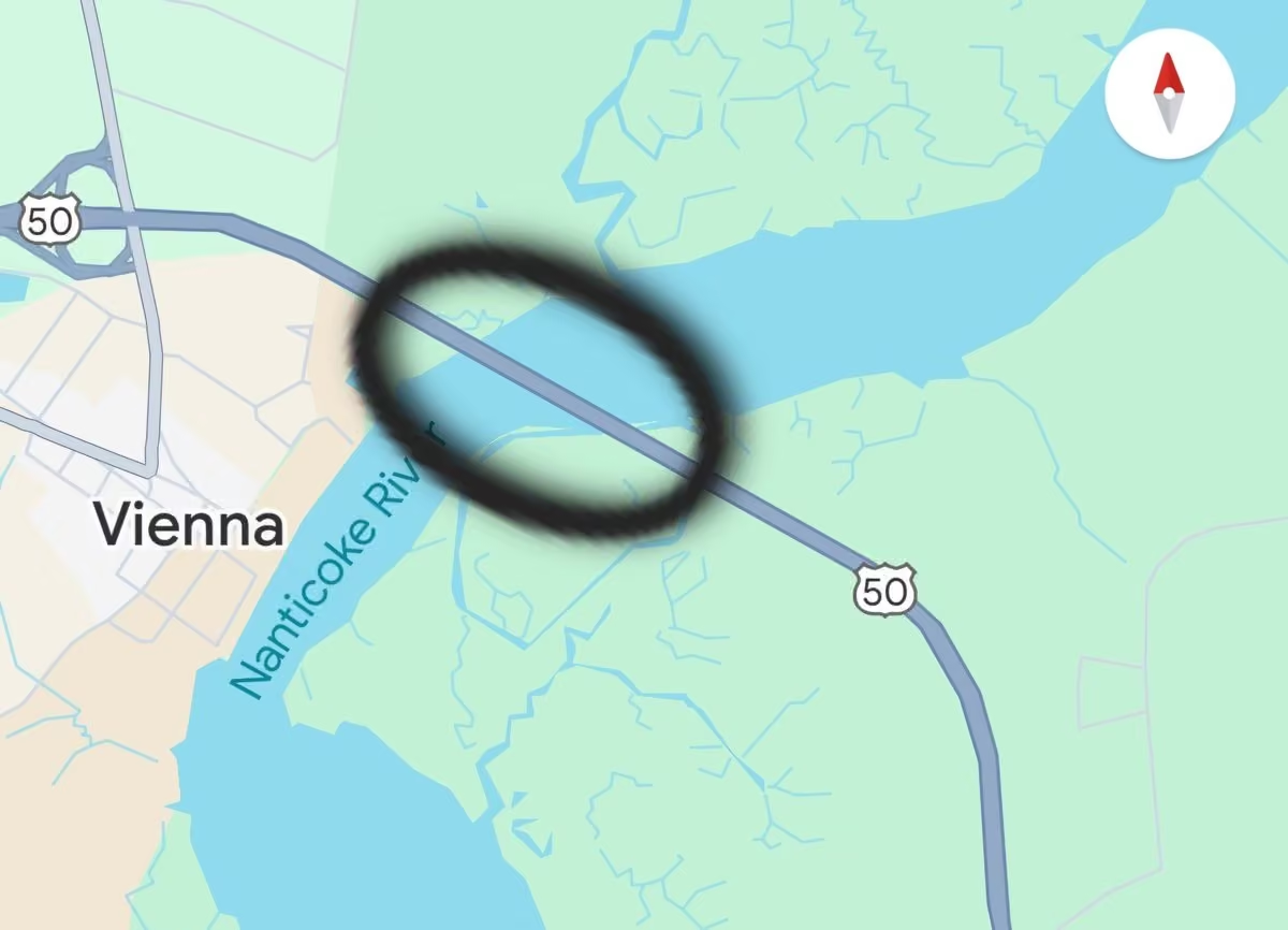
A great example of steam fog/Arctic sea smoke crossing the Nanticoke River in Vienna, MD this morning. This is caused by cold air (low-30s) over much warmer water (mid-60s). Visibility dropped to <100' in just a couple of seconds.
#fog #timelapse
@NWS_BaltWash -
Mike Seidel
@mikeseidel
The highlight of the weekend before #halloween is the Sea Witch Festival Costumed #dog Parade on the boardwalk in Rehoboth Beach, DE.
#doglife #dogloverThis media couldn't be displayed. See it on the original post. -
Mike Seidel
@mikeseidel
🔥EXTREME HEAT🔥
Phoenix has set #record highs 19 days in a row, including the hottest Sept (117°/28th) and Oct (113°/1st & 6th) days on record since 1895. Plus record warm low temps Oct. 1-10. More records could fall Sun (101°) & Mon (100°).
Photo: 7/20/2023
PHX high: 119° -
Mike Seidel
@mikeseidel
Very sad to see someone's home that was flooded by Hurricane Helene 13 days ago on fire during Hurricane Milton. This was likely caused by wind blowing down a power line.
-
Mike Seidel
@mikeseidel
The northern eye wall of #hurricanemilton is battering us in Madeira Beach, FL. We're live on @foxweather
-
Mike Seidel reposted
NWS Tampa Bay
@NWSTampaBay
An extreme wind warning is in effect for Tampa FL, Saint Petersburg FL, Clearwater FL until 9:30 PM EDT for extremely dangerous hurricane winds. Treat these imminent extreme winds as if a tornado was approaching and move immediately to an interior room or shelter NOW!
-
Mike Seidel
@mikeseidel
Squalls with 40 MPH gusts are sweeping across Pinellas County as the eye of #hurricanemilton is 115 miles SW of our location. Storm surge & 100+ MPH gusts will take the debris (miles of it) and "redistribute" it as the worst arrives early this evening. Stay with @foxweather
-
Mike Seidel reposted
National Hurricane Center
@NHC_Atlantic
Hurricane #milton Advisory 15: Milton Back to Category 5 Strength. Florida Residents Should Get Their Families and Homes Ready And Evacuate If Told to Do So. hurricanes.gov
-
Mike Seidel
@mikeseidel
Racing against time! Milton's landfall is ~36 hours away and Pinellas County is trying to get as much of Helene's aftermath off the streets before it hits. But there are piles on miles and miles of local streets.
Coverage continues on @foxweather -
Mike Seidel
@mikeseidel
Miles of debris from Helene remain as Cat. 4 #hurricanemilton bears down on FL. Surge (float) and wind (projectiles) will send these piles in all directions later Wednesday. Stay with @foxweather
for the latest updates. -
Mike Seidel
@mikeseidel
The central pressure of Cat. 5 (180 MPH) #hurricanemilton has dropped 78 mb in 24 hours, from 983 mb ⬇️ 905 mb. A Winter cyclone/Nor'Easter is considered a meteorological "bomb" if the pressure drops 24 mb/24 hours. This is 3x that! Wilma holds the record:
97 mb/24 hours. -
Mike Seidel reposted
Philip Klotzbach
@philklotzbach
#milton continues to rapidly intensify and now has max winds of 175 mph - the strongest Gulf of Mexico #hurricane since Rita (2005).
-
Mike Seidel reposted
National Hurricane Center
@NWSNHC
...MILTON RAPIDLY INTENSIFIES INTO A CATEGORY 5 HURRICANE...
Data from an Air Force Reserve Hurricane Hunter aircraft indicate that Milton has strengthened to a category 5. The max sustained winds are estimated to be 160 mph with higher gusts. hurricanes.gov -
Mike Seidel
@mikeseidel
Dump trucks getting a police escort as Pinellas County rushes to remove piles of debris from Helene before Cat. 4 Hurricane Milton hits on Wednesday with another big surge (8-12') and wind gusts >100 MPH.
We're live on @foxweather -
Mike Seidel
@mikeseidel
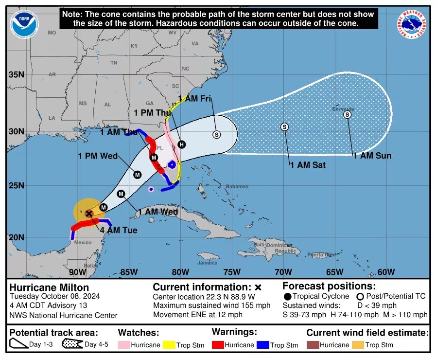
Hurricane Milton is forecast to be a high end Cat. 4 by early Tuesday AM. Hurricane and Storm Surge Watches are up as clean-up from Helene continues. Stay with @foxweather for the latest.
#tropicsThis media couldn't be displayed. See it on the original post. -
Mike Seidel reposted
National Hurricane Center
@NWSNHC
0600 UPDATE - NOAA Hurricane Hunters find #milton to be a Major Category 3 Hurricane. Storm surge and hurricane watches have been issued for portions of Florida.
-
Mike Seidel
@mikeseidel
Hurricane Milton is rapidly intensifying and is forecast to be a major Cat. 3 storm by midday Monday. Landfall expected early Wednesday evening. Look for hurricane and storm surge watches to be issued Monday morning for parts of FL. Stay with @foxweather for the latest.
-
Mike Seidel reposted
Philip Klotzbach
@philklotzbach
For the first time on record, the Atlantic has 3 #hurricanes simultaneously after September (#kirk, #leslie, #milton).
-
Mike Seidel reposted
National Hurricane Center
@NHC_Atlantic
1PM CDT Oct 6: @53rdWRS find #milton rapidly intensifying into a hurricane. Stay up to date with the latest forecast at hurricanes.gov
-
Mike Seidel
@mikeseidel
Ominous skies and damage on the FL Gulf Coast ahead of #milton as residents of North Redington Beach are still cleaning up from Helene. @NHC_Atlantic forecasts a Category 3 #hurricane at landfall on Wednesday. @foxweather has the latest.
#tropics -
Mike Seidel
@mikeseidel
Unfortunately, ANOTHER HURRICANE is forecast to impact the Gulf Coast of FL.
The future "Milton" will bring life-threatening storm surge and wind impacts beginning late Tue/Wed to the areas impacted by #hurricanehelene.
LATEST ADVISORY:
www.nhc.noaa.gov/text/refresh/MIATCPAT4+shtml/051458.shtml
@foxweather -
Mike Seidel reposted
National Hurricane Center
@NHC_Atlantic
NHC will initiate advisories on Tropical Depression Fourteen, located over the southwestern Gulf of Mexico, at 1000 AM CDT (1500 UTC).
-
Mike Seidel reposted
FOX Weather
@foxweather
COLLAPSE: Watch a road bridge in East Tennessee collapse into a river. Known as Kisner Bridge on Highway 107 in the town of Afton, the bridge was no match for the powerful waters of the flooded Nolichucky River.
This media couldn't be displayed. See it on the original post. -
Mike Seidel
@mikeseidel
WOW! Check out how Helene "moved" the beach:
www.facebook.com/share/r/LBqjzMFp8gGvvYLK/ -
Mike Seidel reposted
Craig Ceecee, Ph.D.
@CC_StormWatch
3 1/2 days out on Monday morning, when there wasn't even a defined center (and this was a potential tropical cyclone), the landfall point of #helene was correctly identified within about 10 miles.
Talk about a PERFECT forecast by the NHC. A job VERY well done. -
Mike Seidel
@mikeseidel
I've never seen this many power flashes covering any type of weather. They lit up the sky with a greenish hue in the eye wall of Hurricane Helene.
-
Mike Seidel reposted
Jonathan Erdman
@wxjerdman
Idalia, Debby, now #helene.
3 Big Bend #florida #hurricane landfalls in less than 13 months.
3 of the last 5 hurricanes to landfall in the U.S. in the Big Bend.
All within ~ 25 miles of each other. -
Mike Seidel
@mikeseidel
Taking the eye wall of Hurricane Helene in Perry, FL with a peak wind gust of 99 MPH at 11:10 PM ET. Coverage continues all night on @foxweather
-
Mike Seidel
@mikeseidel
We're moments away from the eye wall of Cat. 4 #hurricane Helene with an Extreme Wind Warning until midnight. Gusts 100 MPH + shortly.
We're live on @foxweather -
Mike Seidel
@mikeseidel
#hurricanehelene is now a Category 3 Major Hurricane with 120 MPH maximum sustained winds as it continues to strengthen. @foxweather is live all night with crews fanned out across FL, GA and SC to show you the multiple impacts.
#tropical #tropics -
Mike Seidel reposted
National Hurricane Center
@NHC_Atlantic
2:25 PM Thursday Update: Air Force hurricane hunters (@53rdWRS) find #helene a dangerous major hurricane. The maximum sustained winds have increased to 120 mph (195 km/h). Follow the latest at hurricanes.gov
-
Mike Seidel reposted
National Hurricane Center
@NHC_Atlantic
Hurricane #helene Advisory 9: Helene Becomes a Hurricane. Expected to Bring Life-Threatening Storm Surge, Damaging Winds, And Flooding Rains to a Large Portion of Florida and The Southeastern United States. hurricanes.gov
-
Mike Seidel
@mikeseidel
This media couldn't be displayed. See it on the original post. -
Mike Seidel
@mikeseidel
Good morning from Keaton Beach where they're making final preps ahead of the landfall of #helene later Thu. Storm surge forecast of 10-15' and some of the homes here are up even higher. We're live on @foxweather
#tropical #tropics -
Mike Seidel
@mikeseidel
Here's the update from St. George Island, FL. Stay with @foxweather for the latest on #helene.
This media couldn't be displayed. See it on the original post. -
Mike Seidel reposted
National Hurricane Center
@NHC_Atlantic
Tropical Storm #helene Advisory 5: Tropical Storm Helene Forms Over the Northwestern Caribbean Sea. Hurricane and Storm Surge Watches Remain in Effect For Portions Of the Florida Gulf Coast. hurricanes.gov
-
Mike Seidel
@mikeseidel
Sunrise over the Gulf Coast as we track the future #hurricane Helene with landfall forecast later Thursday. This will be a BIG storm with impacts well inland including #atlanta.
Hurricane Watches include Tampa.
We're live on @foxweather
#tropics -
Mike Seidel
@mikeseidel
The threat for a significant #hurricane is increasing along parts of the Gulf Coast. @NHC_Atlantic forecasts a high end Cat 2 to make landfall later Thu.
ADVISORY:
www.nhc.noaa.gov/text/refresh/MIATCPAT4+shtml/231459.shtml
Stay with @foxweather for the latest updates on the track & intensity of the future Helene -
Mike Seidel
@mikeseidel
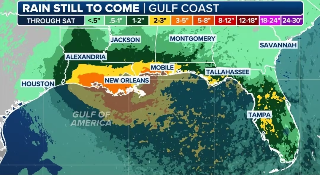
GET READY: Invest 97L is forecast to develop & it's likely a hurricane will make landfall along the Gulf Coast ≈ later Thu. The black line denotes the mean forecast track on the 12Z Euro & GFS spaghetti plots. @foxweather for the latest
SAT LOOP: www.tropicaltidbits.com/sat/satlooper.php?region=97L&prod… -
Mike Seidel
@mikeseidel
This is what happens when 15+" of rain falls ~3 hours into Carolina Beach Lake. It overflows = a level of flash flooding that the locals we talked to have never seen before. And check out where it ended up! Coverage continues on @foxweather
-
Mike Seidel reposted
NWS Wilmington, NC
@NWSWilmingtonNC
Historic rain has fallen across Carolina Beach, Southport, and BSL today. Volunteer gauges have recorded over a foot of rain since midnight. NOAA Atlas 14 shows 12"/12 hr occurs, on average, once every 200 years. 18"/12hr is once every 1000 years! hdsc.nws.noaa.gov/pfds/pfds_map_cont.html?bkmrk=nc #ncwx
-
Mike Seidel
@mikeseidel
#beach dermabrasion courtesy of 60 MPH gusts as our live coverage continues on @foxweather from Wrightsville, Beach, NC
#hurricaneseason -
Mike Seidel
@mikeseidel
Check out the agitated surf here in Wrightsville Beach, NC.
We're live on @foxweather covering the latest tropical threat.This media couldn't be displayed. See it on the original post. -
Mike Seidel
@mikeseidel
Potential Tropical Cyclone #8 has just formed off the coast of SC, forecast to become Tropical Storm Helene before landfall Monday. Live coverage on @foxweather starts Monday at 6 AM ET.
PUBLIC ADVISORY:
www.nhc.noaa.gov/text/refresh/MIATCPAT3+shtml/152056.shtml
@NHC_Atlantic -
Mike Seidel
@mikeseidel
Surf's up at Wrightsville Beach with Invest 95L having a 50% chance of becoming Tropical or Subtropical Storm Helene. Live coverage continues on Monday AM on @foxweather with @mikeseidel along with @BobVanDillen and @1Brandycampbell #hurricaneseason
-
Mike Seidel
@mikeseidel
Taking the eye wall of #francine live on @foxweather in Theriot, LA. Coverage continues all night.
-
Mike Seidel
@mikeseidel
Watches have been upgraded to warnings across LA. We're live in Lafayette with the latest on #francine on @foxweather
#hurricaneseason #tropicsThis media couldn't be displayed. See it on the original post. -
Mike Seidel reposted
National Hurricane Center
@NHC_Atlantic
Tropical Storm #francine Advisory 4: Disturbance Becomes Tropical Storm Francine. Expected to Intensify With Storm Surge and Hurricane Watches Issued For the Louisiana Coast. hurricanes.gov
-
Mike Seidel reposted
FOX Weather
@foxweather
🌀 FRANCINE THREAT: Lafayette, LA braces for another storm. Will history repeat itself? After Hurricane Laura's devastation, residents face the real possibility of more flooding and damage from soon-to-be Tropical Storm Francine. FOX Weather's @mikeseidel is live with the latest.
This media couldn't be displayed. See it on the original post. -
Mike Seidel
@mikeseidel
Heads up TX & LA: we have Potential Tropical Cyclone #6 in the SW Gulf, forecast to strengthen to Tropical Storm Francine on Monday. Here's the latest from @NHC_Atlantic
ADVISORY:
www.nhc.noaa.gov/text/refresh/MIATCPAT1+shtml/082057.shtml
SAT. LOOP:
cdn.star.nesdis.noaa.gov/GOES16/ABI/SECTOR/gm/13/GOES16-G…
Get the latest from @foxweather -
Mike Seidel reposted
National Hurricane Center
@NHC_Atlantic
NHC will initiate advisories on Potential Tropical Cyclone Six, located over the southwestern Gulf of Mexico, at 400 PM CDT (2100 UTC).
-
Mike Seidel reposted
Disaster News
@Top_Disaster
Terrifying winds hits due to Typhoon Yagi in Halong Bay of Quảng Ninh province, Vietnam 🇻🇳 (07.09.2024)
TELEGRAM JOIN 👉 t.me/Disaster_NewsThis media couldn't be displayed. See it on the original post. -
Mike Seidel
@mikeseidel
#phoenix hit 100° today for the 100th day in a row. They shattered their previous record of 76 days in early August.
This follows their hottest summer on record with an average temp. of 98.9°.
There's no end in sight.
#heat #heatwave
@foxweather -
Mike Seidel
@mikeseidel
A rambunctious #storm crushed parts of the NW #atlanta metro with heavy rain, 40+ MPH gusts and pea-sized hail.
1.07" fell in 38 minutes in my gauge: this a HUGE help as officially only .77" has fallen in August.
@NWSAtlanta
@foxweather -
Mike Seidel
@mikeseidel
Another tropical squall dumped ~.50" of rain in 30 minutes on Isle of Palms and immediately kicked in flash flooding on Palm Blvd. Another 2-4" could fall in the area before #debbie finally pulls away Friday. #chs picked up 9.53" Tue-Wed.
@NWSCharlestonSC -
Mike Seidel
@mikeseidel
After #debbie moves inland on Thursday, it'll get picked up by the jet stream and FINALLY get swept NE and out of our hair.
But the flash #flood risk will continue along it's track. Here's the loop & 00Z Euro Ensemble Mean rainfall forecast through midday Sat. -
Mike Seidel reposted
NWS Climate Prediction Center
@NWSCPC
Tropical cyclone development is possible from the Gulf of Mexico to the central Atlantic mid to late Aug. Higher chances (40 to 60%) north of the Greater and Lesser Antilles in mid Aug shifting to the central Atlantic by late Aug. Monitor the situation by following @NWSNHC!
-
Mike Seidel
@mikeseidel
Flash #flooding continues across the SC Low Country and here on Isle of Palms. #debby is going to fester for several days near the coast and dump another 10"+ of rain in spots. We're live on @foxweather @FoxNews & @foxandfriends
#charlestonsc
@NWSCharlestonSC -
Mike Seidel
@mikeseidel
Driving through the eye wall of #debby on I-75 near Live Oak, FL. The area has had over a foot of rain and flash flooding.
-
Mike Seidel
@mikeseidel
The eyewall from #hurricane #debby produced a peak wind gust of 87 MPH. But now, much calmer with #debby making landfall here in Steinhatchee, FL. We're live on @foxweather
-
Mike Seidel
@mikeseidel
We're in outer eye wall of #hurricane #debby in Steinhatchee, FL as the center moves right as us. So far the river is behaving! We'll see you live on @foxweather @FoxNews & @foxandfriends starting at 5 AM ET.
-
Mike Seidel reposted
FOX Weather
@foxweather
FOX Weather Storm Specialist @mikeseidel is in Steinhatchee, Florida where residents are preparing for Tropical Storm #debby. Landfall is expected in the Big Bend region with 6-10 feet of storm surge forecast.
-
Mike Seidel reposted
FOX Weather
@foxweather
RACE IS ON 🌀: Floridians are preparing for likely #tropicalstormdebby's impact. The state has already declared a state of emergency, as time is running out. #foxweather Storm Specialist @mikeseidel in North Redington Beach with the latest updates on the weather conditions.
This media couldn't be displayed. See it on the original post. -
Mike Seidel
@mikeseidel
Potential Tropical Cyclone #4 has formed and is forecast to make landfall as a strong tropical storm (Debby) this weekend. T.S. Warnings are up for parts of the Gulf Coast including #tampa
Lastest @NHC_Atlantic advisory:
www.nhc.noaa.gov/text/refresh/MIATCPAT4+shtml/021456.shtml
#hurricaneseason -
Mike Seidel
@mikeseidel
It's the "Twister Twins" including my good friend, meteorologist and storm chaser @JWatson_Wx and her twin Kimberly on today's @InsideEdition! They were one of the first ones to see "Twisters."
#tornado -
Mike Seidel
@mikeseidel
#baltimore & #dc broke 100° Wed. for the fourth day in a row. This ties their longest stretch of triple-digit #heat back to 1872. For Baltimore it's been 94 years. This follows the Tue. scorcher with 104° in both cities, their hottest in 12 years. ~90°(average) starting Thu.
-
Mike Seidel
@mikeseidel
For all of us #weather Weenies out there.....this could be the greatest commercial ever! Thank you @progressive!
@ItsFlo -
Mike Seidel reposted
NWS Shreveport
@NWSShreveport
Today's weather events across our region in the wake of Hurricane Beryl's remnants are further proof that inland tropical impacts can also be quite extreme. A total of 67 tornado warnings were issued across NWS Shreveport's coverage area, easily the most in a single day event.
-
Mike Seidel reposted
WxChasing- Brandon Clement
@bclemms
#hurricaneberyl vs @bucees sign.
#hurricane #freeport #texas @jpetramala -
Mike Seidel
@mikeseidel
A PWS at the former Matagorda Island Air Force Base reported a maximum sustained wind of 82 MPH and a gust to 98 MPH with #hurricaneberyl
www.wunderground.com/dashboard/pws/KTXMATAG14
Landfall was 4 AM CT. @NHC_Atlantic -
Mike Seidel
@mikeseidel
#hurricaneberyl has made landfall at Matagorda, TX with max sustained winds of 80 MPH. It's moving north at 12 MPH.
Here's the latest @NHC_Atlantic advisory including numerous impacts:
www.nhc.noaa.gov/text/refresh/MIATCPAT2+shtml/080853.shtml -
Mike Seidel reposted
National Hurricane Center
@NHC_Atlantic
July 7th 1100PM CDT Update: National Weather Service Doppler radar near Houston, Texas and @53rdWRS aircraft data indicate #beryl has strengthened and is again a hurricane with maximum sustained winds of 75 mph. For the latest visit hurricanes.gov
-
Mike Seidel reposted
-
Mike Seidel
@mikeseidel
Las Vegas has now hit 119°.
Mike Seidel
@mikeseidel
#lasvegas has set their all-time #record with 118° after hitting 117° five times since 1937. But with the relative humidity of only 3%, the heat index was "only" 106°. Meanwhile #miamifl was 92° with the same heat index. Which do you prefer?
-
Mike Seidel
@mikeseidel
#lasvegas has set their all-time #record with 118° after hitting 117° five times since 1937. But with the relative humidity of only 3%, the heat index was "only" 106°. Meanwhile #miamifl was 92° with the same heat index. Which do you prefer?
-
Mike Seidel
@mikeseidel
Palm Springs, CA has set their all-time #record high with 124°, after hitting 123° four times since 1922. Almost nobody out on the streets or on the golf course at Indian Wells! The extreme heat continues into next week. Las Vegas could break their hottest on record of 117°!
-
Mike Seidel reposted
Colin McCarthy
@US_Stormwatch
Not good to see Category 4 Hurricane #beryl intensifying as its northern eyewall slams the southern part of Jamaica.
Beryl was expected to weaken due to wind shear, but has continued to defy the odds, with sustained winds of 140 mph and gusts to 175 mph. -
Mike Seidel reposted
NOAA Aircraft Operations Center
@NOAA_HurrHunter
OVER THE CARIBBEAN - Inside the eye of Category 5 Hurricane #beryl!
NOAA WP-3D Orion #noaa43 “Miss Piggy” continues operations into Hurricane #beryl to collect data for hurricane forecasting and research.
Visit hurricanes.gov for the latest forecast and advisories. #flynoaa
📸: Lt. Cmdr. Kevin Doremus, NOAA Corps -
Mike Seidel reposted
Philip Klotzbach
@philklotzbach
#hurricane #beryl has intensified to a Category 5 hurricane with max winds of 160 mph - the earliest calendar year Atlantic Category 5 hurricane on record. The prior record was Hurricane Emily on July 17, 2005 at 0UTC.
-
Mike Seidel
@mikeseidel
MUST SEE VIDEO!
@bclemms captured the eyewall of Category 4 Hurricane Beryl as it blasted across the island of Carriacou.
youtu.be/N7ce0TUdiGc -
Mike Seidel
@mikeseidel
The next forecast stop for #beryl is Jamaica on Wednesday.
Philip Klotzbach
@philklotzbach
#hurricane Beryl currently has max winds of 150 mph. Since 2000, the eastern Caribbean (8-20°N, 75-60°W) has had six other 150+ mph #hurricanes: Ivan (2004), Dean (2007), Felix (2007), Matthew (2016), Irma (2017), Maria (2017).
-
Mike Seidel
@mikeseidel
INCREDIBLE for this early in the season! #beryl is now a Cat. 4 #hurricane and the earliest on record in the Atlantic basin, more than a week earlier than Dennis 7/8/2005.
SAT LOOP:
www.star.nesdis.noaa.gov/GOES/sector_band.php?sat=G16&sec…
Latest Updates: @NHC_Atlantic -
Mike Seidel reposted
NWS Storm Prediction Center
@NWSSPC
12:02pm CDT #spc_watch WW 448 TORNADO MA ME NH NY VT 231700Z - 240000Z, #mawx #mewx #nhwx #nywx #vtwx, www.spc.noaa.gov/products/watch/ww0448.html
-
Mike Seidel reposted
Bad Weather Takes
@BadWeatherTake
Footage of the tornado crossing the interstate near Janesville earlier.
#wx #wxtwitter #wiwx #tornado -
Mike Seidel reposted
Carter Murphy 🏔️
@cartermurphy218
Here’s a 1 minute glimpse of the incredible flash flood today on highway 163 between Mexican hat & Valley Of The Gods in far southeastern Utah. Incredible amount of water! This was from the same supercell that dropped golf ball size hail on lake mead #utwx
This media couldn't be displayed. See it on the original post. -
Mike Seidel
@mikeseidel
🔥 Caribou, ME has set a new record high heat index of 103° at noon, topping 101°. 🔥
Temp: 92°
Dewpoint: 75°
RH: 58%
Will they tie/break their all-time high today of 96°, set on this date in 2020 & on 5/22/1977 & 6/29/1944?
Average high today is a cool 72°.
#heat #records -
Mike Seidel reposted
National Hurricane Center
@NHC_Atlantic
10AM CDT June 19: #alberto forms in the western Gulf of Mexico. Tropical storm conditions are expected today within the warning area. Alberto is a very large system with rainfall, coastal flooding, and wind impacts extending far from the center. For more visit
-
Mike Seidel
@mikeseidel
And we're off and running! Potential Tropical Cyclone #1 is forecast to become Tropical Storm Alberto before landfall.
TX Impacts: heavy rain, flash and coastal flooding.
LATEST TRACK:
www.nhc.noaa.gov/refresh/graphics_at1+shtml/234836.shtml?…
LATEST ADVISORY:
www.nhc.noaa.gov/text/refresh/MIATCPAT1+shtml/172335.shtml
@NHC_Atlantic -
Mike Seidel
@mikeseidel
Surf's Up! The pressure gradient between Invest 90L east of FL & high pressure in the Southeast is producing winds ENE 20-25 MPH. Red flags are flying. Otherwise a beautiful day with low 80s and a water temp. of 81°.
Latest Tropical Outlook:
www.nhc.noaa.gov/gtwo.php?basin=atlc&fdays=7 -
Mike Seidel
@mikeseidel
#sunrise over Myrtle Beach at Springmaid Pier as day 2 of the @ametsoc 51st Conference on Broadcast Meteorology gets underway. Added bonus: water temps already in the low 80s. 😃 ⛱️ 🌴
-
Mike Seidel reposted
City of Sunny Isles Beach
@CityofSIB
Continuous rainfall is causing flash flooding on Collins Ave. and interior streets causing disabled vehicles on the roadway. Please stay home or in a safe area. Do NOT drive through flooded streets.
This media couldn't be displayed. See it on the original post. -
Mike Seidel
@mikeseidel
EXTENDED UNTIL 8 PM:
Flash Flood Emergency for parts of Broward & Miami-Dade Counties as more heavy rain trains across the area.
This is LIFE THREATENING.
Ft. Lauderdale picked up 6.66" 1-5 PM and 7.81" today.....now the 4th wettest June day on record.
#flooding #flwx -
Mike Seidel
@mikeseidel
FLASH FLOOD EMERGENCY parts of Broward & Miami-Dade Counties
Ft. Lauderdale picked up 5.56" of rain 1-4 PM and very heavy rain continues.
#flood #flwx -
Mike Seidel reposted
Philip Klotzbach
@philklotzbach
Updated seasonal #hurricane forecast from @ColoradoStateU maintains prediction for very active season: 23 named storms, 11 hurricanes and 5 major hurricanes. Extremely warm tropical Atlantic and likely #lanina are the primary reasons.
tropical.colostate.edu/Forecast/2024-06.pdf -
Mike Seidel
@mikeseidel
It's only the first week of meteorological summer and in Las Vegas it's never been this hot, so early, with a #record high Thu. of 111° & a record warm low temp of 85°.
Also setting records:
Death Valley: 122°
Needles: 115°
Phoenix: 113°
Barstow: 111°
More 🔥 on Friday. -
Mike Seidel reposted
Pete Piringer
@mcfrsPIO
Poolesville, Maryland, tornado @MontgomeryCoMD
-
Mike Seidel reposted
Live Storm Chasers
@LiveStormChaser
TEXAS Record MONSTER Hailstone!
Documented 7.25” hailstone 3 miles WNW of Vigo Park, Texas at 7:37pm Sunday set a new state record (pending) shattering the previous record of 6.4" in Hondo, TX in 2021.
Permission: Val and Amy Castor -
Mike Seidel reposted
NWS Storm Prediction Center
@NWSSPC
PDS Tornado Watch #308 has been issued for much of Oklahoma, southern Kansas and western north Texas until 11 pm CDT. Intense Tornadoes, giant Hail, and damaging winds are likely! Stay weather aware and more info at www.spc.noaa.gov/products/watch/ww0307.html
-
Mike Seidel reposted
Philip Klotzbach
@philklotzbach
NOAA predicts a well above-average Atlantic #hurricane season in 2024, with 17-25 named storms, 8-13 hurricanes and 4-7 major hurricanes. NOAA is forecasting below-average hurricane activity for both the eastern North Pacific and central North Pacific.
www.cpc.ncep.noaa.gov/products/outlooks/hurricane.shtml -
Mike Seidel reposted
NWS Storm Prediction Center
@NWSSPC
12:32pm CDT #spc_watch WW 286 TORNADO TX 221730Z - 230100Z, #txwx, www.spc.noaa.gov/products/watch/ww0286.html
-
Mike Seidel
@mikeseidel
After an incredible 32+ years at TWC, I'm embarking on a new journey due to company restructuring. I'm immensely grateful to all of you who've been part of this amazing ride!
As hurricane season approaches, I can't wait to reconnect on another network.
Stay tuned! -
Mike Seidel reposted
NWS Storm Prediction Center
@NWSSPC
There is a Tornado Watch in effect for parts of the Florida Panhandle until 7 PM EDT. A couple tornadoes, damaging winds up to 75 mph, and isolated large hail up to 1.5 inches are expected this afternoon. Stay weather aware.
-
Mike Seidel reposted
NWS Storm Prediction Center
@NWSSPC
12:33pm CDT #spc_watch WW 233 TORNADO LA TX CW 121730Z - 130000Z, #lawx #txwx #cwwx, www.spc.noaa.gov/products/watch/ww0233.html
-
Mike Seidel reposted
NWS Storm Prediction Center
@NWSSPC
Storms moving offshore this morning brought the end to a very active 16 days (Apr 25-May 10) of severe weather in continental US.
The @NWSSPC issued 99 Watches and 237 Mesoscale Discussions during this period, with 3280+ Warnings issued from local @NWS forecast offices. -
Mike Seidel reposted
Chris Suchan
@ChrisSuchanWOAI
It's official. Yesterday's giant or gorilla size hailstone in Johnson City is the 2nd largest hailstone verified by the National Weather Service in Texas. State record remains the Hondo hailstone from 2021
📷 Kathryn Puckett (Johnson City hail pic)
@natwxdesk #txwx -
Mike Seidel reposted
-
Mike Seidel
@mikeseidel
This is a Particularly Dangerous Situation!
STAY ALERT! -
Mike Seidel reposted
NWS Storm Prediction Center
@NWSSPC
11:37am CDT #spc_watch WW 187 TORNADO KS NE 061635Z - 070000Z, #kswx #newx, www.spc.noaa.gov/products/watch/ww0187.html
-
Mike Seidel reposted
NWS Storm Prediction Center
@NWSSPC
A dangerous outbreak of severe thunderstorms is expected this afternoon into tonight across parts of central/eastern KS and much of OK. Multiple strong, long-track tornadoes, very large hail (2-4 inch) and damaging gusts to 80 mph are all possible this afternoon into tonight.
-
Mike Seidel reposted
NWS Storm Prediction Center
@NWSSPC
5/5/2024 6:42 PM CDT: Significant severe weather is still expected across portions of the Plains states tomorrow, including the potential for strong tornadoes. Please make or review your severe weather safety plans, and stay tuned for forecast updates at www.spc.noaa.gov/products/outlook/
-
Mike Seidel reposted
NWS Storm Prediction Center
@NWSSPC
12:39pm CDT #spc Day2 Outlook Moderate Risk: across west-central/central Oklahoma and south-central Kansas www.spc.noaa.gov/products/outlook/day2otlk.html
-
Mike Seidel reposted
NWS Omaha
@NWSOmaha
Preliminary Tornado Track Maps of the Arbor Day Tornado Outbreak 2024
We will continue to survey and add to this site in the upcoming weeks.
Our hearts are with everyone impacted.
For individual track maps and more information
www.weather.gov/oax/april262024 -
Mike Seidel
@mikeseidel
OMAHA PROUD! ❤️
This is the largest post-storm clean-up I've seen in over 30 years @weatherchannel Hundreds turned out in Elkhorn to help their neighbors sift through what was left. It was just amazing to watch! Superb job #omaha!
(only minor injuries from the tornado)
@OWHnews -
Mike Seidel reposted
NWS Storm Prediction Center
@NWSSPC
7:52pm CDT #spc_watch WW 152 TORNADO OK TX 280050Z - 280800Z, #okwx #txwx, www.spc.noaa.gov/products/watch/ww0152.html
-
Mike Seidel reposted
The Weather Channel
@weatherchannel
42 tornado warnings were issued by @NWSOmaha Friday as a tornado outbreak swept across Nebraska and Iowa, demolishing homes and buildings.
@MikeSeidel is in Elkhorn with a look at the damage:This media couldn't be displayed. See it on the original post. -
Mike Seidel reposted
NWS Storm Prediction Center
@NWSSPC
A Tornado Watch is in effect for parts of western Oklahoma and western North Texas until 8 PM CDT. This is a particularly dangerous situation. Several tornadoes (a few intense), very large hail (2-3 in.), and wind gusts up to 75 mph are the expected hazards. Stay weather aware.
-
Mike Seidel
@mikeseidel
Extensive damage in Elkhorn, NE west of Omaha from Friday's (likely) long-track #tornado. There was a 34-minute lead time with the warning thanks to
@NWSOmaha who issued 42 tornado warnings, the most in 5 years from a NWS office. We're live on @weatherchannel -
Mike Seidel reposted
CreighTakes
@CreighTakes
210th and Maple (Elkhorn, NE)💔
-
Mike Seidel
@mikeseidel
This is the #tornado warned storm that moved over downtown #omaha. A few minutes later the airport reported a funnel cloud.
We had marble-sized hail at our location. @weatherchannel coverage continues until midnight ET/11 PM CT. Remain Alert! -
Mike Seidel reposted
James Pettus
@PettusWX
GET UNDERGROUND
MASSIVE TORNADO -
Mike Seidel reposted
NWS Storm Prediction Center
@NWSSPC
3:48pm CDT #spc_watch WW 142 TORNADO IA KS MO 262045Z - 270200Z, #iawx #kswx #mowx, www.spc.noaa.gov/products/watch/ww0142.html
-
Mike Seidel reposted
Corey Gerken
@CoreyGerkenWX
Stong tornado in Lincoln, Nebraska! #newx @foxweather @radaromega.
-
Mike Seidel reposted
Aaron Jayjack
@aaronjayjack
VIOLENT tornado just crossed the interstate 80 Lincoln, NE @RadarOmega #newx
This media couldn't be displayed. See it on the original post. -
Mike Seidel
@mikeseidel
A weekend of #severe weather ahead across the Plains & Midwest.....remain alert!
A #tornado Watch is up until 7 PM CT including #omaha. We're live on @weatherchannel starting at 4 ET/3CT. -
Mike Seidel reposted
NWS Storm Prediction Center
@NWSSPC
10:13am CDT #spc_watch WW 139 TORNADO OK TX 261510Z - 262300Z, #okwx #txwx, www.spc.noaa.gov/products/watch/ww0139.html
-
Mike Seidel reposted
NWS Storm Prediction Center
@NWSSPC
5:03pm CDT #spc_watch WW 134 TORNADO CO KS OK TX 252200Z - 260500Z, #cowx #kswx #okwx #txwx, www.spc.noaa.gov/products/watch/ww0134.html
-
Mike Seidel reposted
NWS Storm Prediction Center
@NWSSPC
4/11: A Tornado Watch is in effect for portions of southeast OH, eastern KY, southwest PA, far western VA, and WV until 9pm EDT. A few tornadoes, damaging winds, and isolated severe hail are all possible. Monitor for possible warnings, and have a severe-weather safety plan.
-
Mike Seidel reposted
Philip Klotzbach
@philklotzbach
NOAA's latest probabilistic ENSO forecast gives 80% chance of #lanina conditions for peak of Atlantic hurricane season (August-October). La Nina typically increases Atlantic #hurricane activity via decreases in vertical wind shear. NOAA blog post here:
www.climate.gov/news-features/blogs/enso -
Mike Seidel reposted
NWS Storm Prediction Center
@NWSSPC
6:32am CDT #spc_watch WW 104 TORNADO FL GA CW 111130Z - 111900Z, #flwx #gawx #cwwx, www.spc.noaa.gov/products/watch/ww0104.html
-
Mike Seidel
@mikeseidel
Very likely a #tornado did this damage in Slidell. ~50 people were rescued from the Courtney Heights Apts. Thankfully no serious injuries reported. Many had to deal with flash flooding including #nola: 6.24" of rain; 3rd wettest April day.
We're live on @weatherchannel -
Mike Seidel reposted
NWS Storm Prediction Center
@NWSSPC
1:12pm CDT #spc_watch WW 103 TORNADO AL FL GA CW 101810Z - 110100Z, #alwx #flwx #gawx #cwwx, www.spc.noaa.gov/products/watch/ww0103.html
-
Mike Seidel
@mikeseidel
Heavy rain has been the only impact so far in Hattiesburg, MS but a #tornado Watch continues until 1 PM CT and the #flood Watch until 7 PM CT. Additional tornado watches parts of LA, AL & the FL Panhandle. @JMichaelsNews soon from Montgomery.
We're Iive on @weatherchannel -
Mike Seidel reposted
NWS Storm Prediction Center
@NWSSPC
9:57am CDT #spc_watch WW 102 TORNADO AL FL CW 101455Z - 102200Z, #alwx #flwx #cwwx, www.spc.noaa.gov/products/watch/ww0102.html
-
Mike Seidel reposted
NWS Storm Prediction Center
@NWSSPC
3:48am CDT #spc_watch WW 100 TORNADO LA TX CW 100845Z - 101400Z, #lawx #txwx #cwwx, www.spc.noaa.gov/products/watch/ww0100.html
-
Mike Seidel reposted
NWS Storm Prediction Center
@NWSSPC
4/9: A Tornado Watch is in effect for parts of east TX and northern LA until 9pm CDT. A few tornadoes (some possibly strong), scattered damaging winds, and large hail are all possible. Have a severe-weather safety plan, and monitor for potential warnings. www.spc.noaa.gov
-
Mike Seidel
@mikeseidel
Steve Schumacher from @weatherchannel is an incredibly talented Paramotor pilot. He rented a cargo van and drove to Fairfield, IL to capture this breathtaking view of the eclipse... a mile above the ground!
This media couldn't be displayed. See it on the original post. -
Mike Seidel reposted
Jen Carfagno
@JenCarfagno
It truly is an experience that is hard to find the words to describe it! The deciding where to travel, analyzing of cloud layers in the forecast… plus all of the emotions of witnessing a #totalsolareclipse!
Thank you to @mikeseidel & Sam Seidel! Mike took the sun pictures!! -
Mike Seidel reposted
NWS Storm Prediction Center
@NWSSPC
7:52pm CDT #spc_watch WW 92 TORNADO LA TX 090050Z - 090600Z, #lawx #txwx, www.spc.noaa.gov/products/watch/ww0092.html
-
Mike Seidel reposted
NWS Weather Prediction Center
@NWSWPC
[4/7/2024]
Updated Key Messages for tomorrow's total solar eclipse and cloud cover forecast are available. High clouds spanning across parts of the totality path are likely, but may not completely obscure the eclipse. For local forecasts visit weather.gov. -
Mike Seidel
@mikeseidel
This April #snowstorm has provided some pretty decent end of the season #skiing in the Catskills north of #nyc. @huntermtn has picked up 13" of snow so far. It's 27° with 24 trails and 4 lifts open.
Grab those runs while you can!
#tormund -
Mike Seidel reposted
Kathryn Prociv
@KathrynProciv
Strongest #earthquake to strike New Jersey in nearly 250 years, and 3rd strongest on record for the state in 280 years of record-keeping (1737-2017). The only 2 stronger ones: a 5.2 mag in 1737 and 5.3 mag in 1783! Source: www.nj.gov/njoem/mitigation/pdf/2019/mit2019_section5-5_E…
Kathryn Prociv
@KathrynProciv
4.7 magnitude #earthquake just shook all of New York City! Everything in my apartment on the 25th floor in Midtown was shaking. WOW! earthquake.usgs.gov/earthquakes/eventpage/at00sbh3yv/exec…
-
Mike Seidel reposted
New York Metro Weather
@nymetrowx
NYC, NJ EARTHQUAKE: Preliminary magnitude 4.8 earthquake occurred a short time ago 18 miles north of Plainfield, NJ (magnitude via USGS). This data is unofficial and will be refined as we move forward. No tsunami risk is anticipated.
-
Mike Seidel reposted
Philip Klotzbach
@philklotzbach
Atlantic seasonal #hurricane forecast from @ColoradoStateU calls for very active season: 23 named storms, 11 hurricanes & 5 major hurricanes. Extremely warm tropical Atlantic and likely #lanina are the primary reasons.
tropical.colostate.edu/Forecast/2024-04.pdf -
Mike Seidel reposted
NWS Storm Prediction Center
@NWSSPC
7:02pm CDT #spc_watch WW 82 TORNADO AL GA MS 030000Z - 030700Z, #alwx #gawx #mswx, www.spc.noaa.gov/products/watch/ww0082.html
-
Mike Seidel reposted
NWS Storm Prediction Center
@NWSSPC
9:52am CDT #spc_watch WW 75 TORNADO KY TN 021450Z - 022000Z, #kywx #tnwx, www.spc.noaa.gov/products/watch/ww0075.html
-
Mike Seidel reposted
NWS Storm Prediction Center
@NWSSPC
10:33pm CDT #spc_watch WW 71 TORNADO IL MO 020330Z - 020800Z, #ilwx #mowx, www.spc.noaa.gov/products/watch/ww0071.html
-
Mike Seidel
@mikeseidel
A #hail storm just proceeded a #tornado warning at our location in metro St. Louis. A #tornado Watch is up until midnight CT:
www.spc.noaa.gov/products/watch/ww0068.html
We're live on @weatherchannel
Remain Alert! -
Mike Seidel reposted
NWS Storm Prediction Center
@NWSSPC
4:52pm CDT #spc_watch WW 68 TORNADO IL MO 012150Z - 020500Z, #ilwx #mowx, www.spc.noaa.gov/products/watch/ww0068.html
-
Mike Seidel reposted
The Weather Channel
@weatherchannel
NEW: Tuesday’s severe weather threat has escalated with a TOR:CON up to 7 for most of Ohio, indicating the possibility of EF2 or stronger tornadoes.
We have more details on air and on our TV app: streamtwc.com -
Mike Seidel reposted
NWS Storm Prediction Center
@NWSSPC
3:28pm CDT #spc_watch WW 67 TORNADO KS MO 012025Z - 020400Z, #kswx #mowx, www.spc.noaa.gov/products/watch/ww0067.html
-
Mike Seidel reposted
NWS Storm Prediction Center
@NWSSPC
3/25 7pm CDT: Tornado Watch #62 is in effect for portions of southeastern LA and central/southern MS until 2am CDT. The primary concerns are a few tornadoes (some possibly strong) and damaging winds, though isolated large hail is also possible. Stay tuned for possible warnings.
-
Mike Seidel reposted
NWS Storm Prediction Center
@NWSSPC
1:46pm CDT #spc_watch WW 61 TORNADO AR LA TX 251845Z - 260100Z, #arwx #lawx #txwx, www.spc.noaa.gov/products/watch/ww0061.html
-
Mike Seidel
@mikeseidel
Elise Clark is welcoming Spring in North Woodstock, NH with #snow! Spring gets underway with the "Vernal Equinox" at 11:06 PM ET tonight. Up to 7" fell in VT following below average #snowfall totals this season for everyone in the Northeast.
-
Mike Seidel
@mikeseidel
Here's just some of the path of destruction from last night's #tornado in Lakeview, OH. We're live on @weatherchannel
This media couldn't be displayed. See it on the original post. -
Mike Seidel
@mikeseidel
We're flying the safest route on @Delta to avoid the #severe storms and turbulence between #atlanta & Columbus.
Just a few minor bumps over the Carolinas. We'll see you this afternoon on @weatherchannel covering the #tornado aftermath. -
Mike Seidel reposted
NWS Storm Prediction Center
@NWSSPC
11:12am CDT #spc_watch WW 42 TORNADO OK TX 141610Z - 142300Z, #okwx #txwx, www.spc.noaa.gov/products/watch/ww0042.html
-
Mike Seidel reposted
NWS Storm Prediction Center
@NWSSPC
Severe Weather Key Messages for Thursday 3/14/2024
Severe storms likely across OK/AR and MO. Severe storms are also likely farther northeast. Hail, damaging winds and a few tornadoes are likely from midday into the evening and overnight. See www.spc.noaa.gov for info. -
Mike Seidel
@mikeseidel
It's the biggest #snowstorm of the season for most of CO, underway in Blackhawk with 2-3' forecast across the Foothills and a ~foot in metro #denver (March is their snowiest month.) Winter Storm Warning into Friday AM.
LIVE CAM via @AmeristarBH:
ameristar.click2stream.com -
Mike Seidel reposted
NWS Storm Prediction Center
@NWSSPC
5:42am CST #spc_watch WW 34 TORNADO FL GA CW 091140Z - 091900Z, #flwx #gawx #cwwx, www.spc.noaa.gov/products/watch/ww0034.html
-
Mike Seidel reposted
NWS Storm Prediction Center
@NWSSPC
A tornado watch is in effect until 9 PM CST for parts of southeast Louisiana, southern Mississippi, and southwestern Alabama. A couple tornadoes as well as large hail and damaging winds are possible this afternoon/evening. #lawx #mswx #alwx
-
Mike Seidel
@mikeseidel
The U.S. had its warmest winter on record, capped off by the third-warmest February recorded.
www.noaa.gov/news/us-had-its-warmest-winter-on-record -
Mike Seidel reposted
Colin McCarthy
@US_Stormwatch
Abandoned semi truck buried in the snow on I-80 EB in Truckee, with very dangerous whiteout conditions ongoing.
This is why they closed I-80.
#cawx -
Mike Seidel reposted
Colin McCarthy
@US_Stormwatch
Severe whiteout conditions on I-80 near Donner Pass.
Expecting the highway to close shortly. #cawx -
Mike Seidel
@mikeseidel
A gusty squall line along the #coldfront blew through #atlanta last hour with a wind gust of 63 MPH @PDKAirport & 56 MPH @ATLairport
This is the view looking NW near @weatherchannel
#cold
📹@WayneVernoThis media couldn't be displayed. See it on the original post. -
Mike Seidel
@mikeseidel
Fortunately just lightning and showers so far in Louisville, but a #tornado watch continues until 6 AM ET.
-
Mike Seidel
@mikeseidel
Live coverage with @TWCChrisBruin is underway in #chicago on @weatherchannel
NWS Storm Prediction Center
@NWSSPC
3:57pm CST #spc_watch WW 25 TORNADO IA IL IN WI LM 272155Z - 280400Z, #iawx #ilwx #inwx #wiwx #lmwx, www.spc.noaa.gov/products/watch/ww0025.html
-
Mike Seidel reposted
NWS Storm Prediction Center
@NWSSPC
The severe weather threat has increased to an enhanced risk (Level 3 of 5) across northern IL/southern WI (large hail and a few tornadoes), and in the Ohio Valley (damaging wind and tornadoes, some which may be strong).
-
Mike Seidel
@mikeseidel
From 🔥 to 🧊
Check out these 50-60° temperature plunges Tuesday night. But it quickly warms back up at the end of the week. 😃
#extreme -
Mike Seidel
@mikeseidel
How about these beautiful scenes in Central Park! It's been 2 years since NYC had a plowable snowfall, but today it's the real deal with 5-10" in the Tri-State area and rates 1"/hour. Already 1000+ flights canceled. Coverage of #lorraine continues on @weatherchannel
-
Mike Seidel reposted
CBS Mornings
@CBSMornings
More than 45 million people could be affected by a major winter storm in the Northeast, with New York and Boston potentially seeing the most snowfall in about two years.
@weatherchannel’s @mikeseidel breaks down the forecast from a snowy Central Park.This media couldn't be displayed. See it on the original post. -
Mike Seidel reposted
Brian McNoldy
@BMcNoldy
As of February 7, the tropical east Atlantic sea surface temperature is as warm as it would typically be on JUNE 7. The anomaly, averaged over the area shown on this map, is +1.26°C... with areas off the west coast of Africa exceeding +4°C.
-
Mike Seidel
@mikeseidel
Fortunately this is the only flooding in the area: the San Diego River is hovering just below minor flood stage & impacting several roads around the Fashion Mall. The Flood Watch continues through tonight. So far "just" 1.47" of rain. Live coverage continues on @weatherchannel
-
Mike Seidel reposted
Jonathan Erdman
@wxjerdman
From #weather historian Christopher Burt:
L.A. just had its second heaviest 24-hour rainfall in records dating to 1877:
1. 7.36" (Dec. 31 - Jan. 1 1933-34)
2. 6.65" (Feb. 4-5, 2024; Sun. aftn - Mon. aftn)
47% of their average annual rainfall in just 24 hours! #larain #cawx -
Mike Seidel reposted
The Weather Channel
@weatherchannel
Hurricane-force gusts have left a trail of damage in California.
Take a look at the impacts in Santa Cruz with @MikeSeidel:This media couldn't be displayed. See it on the original post. -
Mike Seidel
@mikeseidel
These massive Eucalyptus trees were blown down by Sunday's wind gusts of 60+ MPH smashing cars on this hillside above the Pacific. Fortunately the power here is buried. But 11% of Santa Cruz County is in the dark this morning.
We're live on @weatherchannelThis media couldn't be displayed. See it on the original post. -
Mike Seidel
@mikeseidel
We're covering aftermath from Santa Cruz County 11 AM - 3 PM ET.
The Weather Channel
@weatherchannel
We have crews stationed LIVE in the field today as a powerful atmospheric river slams into California.
Watch on air or on our TV app: streamtwc.com -
Mike Seidel
@mikeseidel
Check out this sea foam "vortex" at the base of the Santa Cruz pier.
15' waves, 50 MPH winds and a building led to this captivating visual. -
Mike Seidel
@mikeseidel
Watch as he goes airborne above the huge surf thanks to 60+ MPH wind gusts. [22' waves off Pt. Sur] Flood Watches & High Wind Warnings into #socal as power outages mount. Special coverage tonight at 10 ET/7 PT on @weatherchannel
-
Mike Seidel
@mikeseidel
Special coverage of the CA #storm tonight at 10 PM ET/7 PM PT on @weatherchannel
-
Mike Seidel reposted
The Weather Channel
@weatherchannel
Southern California is facing a rare high-risk for flash flooding today.
Our @MikeSeidel, @JMichaelsNews, and
@TWCChrisWarren are LIVE in the field, bringing you the latest on this multi-day atmospheric river storm. -
Mike Seidel
@mikeseidel
A very rare "Hurricane Force Wind Warning" has been issued!
NWS Bay Area 🌉
@NWSBayArea
Extremely Dangerous Winds.
The waters from the Big Sur Coast to 60 nautical miles out have been upgraded to Hurricane Force Wind Warnings for winds 35 to 55 kt with gusts up to 80 knots (roughly 92 mph).
#cawx -
Mike Seidel
@mikeseidel
The "Pineapple Express" is taking direct aim right at CA with #flooding rain, wind gusts 60+ MPH and battering surf. We'll be out in the #storm starting at 8 AM ET Sunday on @weatherchannel
-
Mike Seidel reposted
The Weather Channel
@weatherchannel
The #groundhogday results are in!
Phil didn’t see his shadow, meaning we'll have... an early spring!
#sponsored by @bmsnewsThis media couldn't be displayed. See it on the original post. -
Mike Seidel
@mikeseidel
Washington's Reagan and Dulles Airports have set their warmest January temps on record!
Reagan: 80°
Dulles: 79°
This is the earliest 80° by 3 weeks at Reagan (2/21/2018) and tops the previous January #record at Dulles by 4°.
#washingtondc -
Mike Seidel
@mikeseidel
Tropical downpours sure beats the heck out of 11° last Sunday! 3.95" in my gauge since yesterday morning and 9.73" in January.
(The waterfall loves it.) #flood watches continue in parts of 11 states. The latest on @weatherchannel
#atl @NWSAtlanta -
Mike Seidel
@mikeseidel
Freezing rain this morning from parts of OK/AR/MO/IL. But with temps climbing above freezing through the day, everybody goes over to rain. Keep an eye on those sidewalks and elevated road surfaces. We're live on @weatherchannel
#ice #winterstorm -
Mike Seidel
@mikeseidel
Round #2
The plow convoy is at it again @BUFAirport Niagara International Airport with #snow falling and another foot+ on the way.
Here's the #lakeeffect snow warning from @NWSBUFFALO
forecast.weather.gov/showsigwx.php?warnzone=NYZ012&warnco… -
Mike Seidel reposted
NWS New York NY
@NWSNewYorkNY
It's been 701 days since Central Park last recorded an inch of snow on a calendar day.
Latest totals as of 7 am:
❄️Since midnight -- 1.0"
❄️Storm total -- 1.4"
The streak has ended! #nywx -
Mike Seidel
@mikeseidel
Hanging out with @BuffaloBills fans at 12° and 0° windchill with huge piles of #snow. 41.3" fell in nearby Hamburg. Kickoff vs. the @steelers at 4:30 PM ET.
📷 photog @JoeFloccari -
Mike Seidel reposted
The Weather Channel
@weatherchannel
#billsmafia want to earn some cold hard cash?
@BuffaloBills fans can help get @HighmarkStadm ready for tomorrow's game and earn $20 an hour shoveling snow.
Our @mikeseidel is LIVE with a peek at the weather conditions to help you decide. -
Mike Seidel
@mikeseidel
White out! This #lakeeffect band is producing 3"+ hour snowfall rates. We're live 5-8 PM ET on @weatherchannel
-
Mike Seidel
@mikeseidel
Heavy #snow and gusts to 64 MPH @BUFAirport = whiteouts.
Luckily the visibility came up so we could get in, but take a look at the taxiways. We'll see you live on @weatherchannel starting at 5 PM ET.
#lakeeffect #snowstorm
@NWSBUFFALO -
Mike Seidel reposted
Buffalo Bills
@BuffaloBills
Current scene at Highmark Stadium.
Stay safe tonight, Bills Mafia. ❄️ -
Mike Seidel reposted
Adam Schefter
@AdamSchefter
Now confirmed: Due to the winter storm, the Steelers-Bills wild-card game officially has been postponed to 4:30 ET on Monday.
-
Mike Seidel
@mikeseidel
Wrap around #snow showers this morning as the #arctic air spills in tonight, sending temps <0° and wind chills <-20°. And this dangerous cold will stick around.
We're live on @weatherchannel
#winter #brutal -
Mike Seidel reposted
The Weather Channel
@weatherchannel
“It will be like a skating rink in the morning.”
@MikeSeidel is in Milwaukee, Wisconsin, with the latest on road conditions. #gerriThis media couldn't be displayed. See it on the original post. -
Mike Seidel
@mikeseidel
Wet #snow and 30-40 MPH gusts on the lakefront in Milwaukee as we watch sub-zero cold sweeping in. We're live on @weatherchannel 3-7 PM ET.
#gerri -
Mike Seidel
@mikeseidel
But wait, there's more! The third #snowstorm in a week is going to dump more snow from the Midwest into New England. Plus, another threat of #severewx and #tornadoes. The @weatherchannel has the latest.
#gerri -
Mike Seidel
@mikeseidel
But wait, there's more! The third #snowstorm in a week is going to dump more snow from the Midwest into New England. Plus, another threat of #severewx and #tornadoes. The @weatherchannel has the latest.
#gerri -
Mike Seidel reposted
The Weather Channel
@weatherchannel
Midwest cities like Chicago could face their most frigid temperatures so far this winter season by the end of the week. #finn
@MikeSeidel shares the latest from Rockford, Illinois:This media couldn't be displayed. See it on the original post. -
Mike Seidel
@mikeseidel
Leaving @BostonLogan behind and heading to the Midwest for the next #snowstorm. We'll see you out in the ❄️ Tuesday afternoon on @weatherchannel
#finn #snowfall -
Mike Seidel
@mikeseidel
It was a terrific afternoon of sledding on the hill at Elk Reservation. I even managed to take a few trips without mowing down any kids. Everyone was in high spirits! Next stop: the Midwest and potential #blizzard #finn. The latest forecast on @weatherchannel
#snowstorm -
Mike Seidel
@mikeseidel
4" of #snow so far in Natick, MA with another 3-5" today as temps fall and winds pick up. We'll see you on @weatherchannel 11 AM - 4 PM ET covering the first significant snowfall in 2 years. FYI: @BostonLogan 0" and 35°.
#snowstorm
@NWSBoston -
Mike Seidel reposted
The Weather Channel
@weatherchannel
Ten states are currently under winter storm warnings, and parts of the Northeast are bracing for double-digit snowfall. #ember
@MikeSeidel gives an update from Cambridge, Massachusetts:This media couldn't be displayed. See it on the original post. -
Mike Seidel
@mikeseidel
We'll see live 5-9 PM ET to preview the storm in metro Boston.
The Weather Channel
@weatherchannel
We have teams stationed across the Northeast today for Winter Storm #ember!
No cable? Watch our LIVE field coverage on our TV app: streamtwc.com -
Mike Seidel
@mikeseidel
The latest forecasts from the 12Z Euro Ensemble Mean, showing the total #snowfall (10:1) and the odds of 6"+ of snow. Still the big forecast question is where does the rain-snow line set-up relative to DC-Baltimore-Philly. @weatherchannel has the latest.
#snow -
Mike Seidel
@mikeseidel
The first flakes of the season in metro #atlanta. I had to drive up Sweat Mt. (1688') in Marietta to catch them. It was 36°. The last 1" snowfall at the airport was 1/17/2018. The 30-year average is 2.2"
#snow #squint
@NWSAtlanta -
Mike Seidel
@mikeseidel
#whitechristmas drought: the smallest area (17.6%) since records began, but likely the lowest in many years. Fresh #snow falling today in NE & SD, otherwise you're likely living >5000'. Were you one of the lucky ones? ❄️
@HeatherZWeather for the maps -
Mike Seidel reposted
CBS Evening News with Tony Dokoupil
@CBSEveningNews
Two people were killed by falling trees and many Americans remain without power following a dangerous storm that swept along the East Coast unleashing heavy rain and strong winds.
This media couldn't be displayed. See it on the original post. -
Mike Seidel reposted
The Weather Channel
@weatherchannel
Much of the Northeast is getting swamped with heavy rain and strong wind gusts.
@MikeSeidel is LIVE in Boston, Massachusetts:This media couldn't be displayed. See it on the original post. -
Mike Seidel reposted
NWS Charleston, SC
@NWSCharlestonSC
RECORD ALERT: Prelim max tide in the Charleston Harbor is 9.86 ft MLLW. This is the 4th highest tide on record and well above the highest tide for a non-tropical system. That record was 8.81 ft MLLW set on 01/01/1987. Widespread dangerous flooding continues. #chswx #scw
-
Mike Seidel reposted
The Weather Channel
@weatherchannel
Widespread heavy rain is increasing the risk of flooding and prompting coastal towns along the Atlantic to be on alert for dangerous surf.
@MikeSeidel gives an update from Folly Beach, South Carolina:This media couldn't be displayed. See it on the original post. -
Mike Seidel
@mikeseidel
Flash Flooding continues across Charleston County as up to 4.5" of rain has fallen. Meanwhile the Charleston River gauge has set a non-tropical record with 9.23' above MLLW.
water.weather.gov/ahps2/hydrograph.php?gage=chts1&wfo=chs -
Mike Seidel reposted
NWS Charleston, SC
@NWSCharlestonSC
Tides in Charleston Harbor are still rising. 9.23 ft MLLW at last check. FYI, this is the highest tide on record not associated with a tropical system; previous 8.81 ft MLLW set on 1/1/1987. #chswx #scwx
-
Mike Seidel
@mikeseidel
High tide has swallowed up Folly Beach, SC & the Charleston Harbor tode gauge is in major flood stage at 8.6'.
water.weather.gov/ahps2/hydrograph.php?gage=chts1&wfo=chs
The #storm is tracking up the entire East Coast today into Monday. -
Mike Seidel reposted
NWS Charleston, SC
@NWSCharlestonSC
Flash Flood Warning including Charleston SC, North Charleston SC and Mount Pleasant SC until 1:00 PM EST
-
Mike Seidel
@mikeseidel
Wind (40 MPH gusts) and rain (3-5") are ramping up here at Folly Beach, SC as a #storm races up the East Coast today-Monday. The late AM high tide could produce major flooding. We're live on @weatherchannel
-
Mike Seidel
@mikeseidel
Clarksville, TN #tornado preliminary rating EF3 with 150 MPH winds. www.newschannel5.com/news/preliminary-report-shows-ef3-to…
-
Mike Seidel reposted
Brandon Davis
@BrandonDavisBD
Tennessee tornado 2023. Please be safe.
Friend from my wrestling academy captured this insane video in Madison. Please be safe. -
Mike Seidel reposted
R A W S A L E R T S
@rawsalerts
🚨#breaking: A Tornado Emergency has been issued for a extremely large and violent tornado on the ground
📌#hendersonville | #tn
The National Weather Service has issued a tornado emergency for Hendersonville, Gallatin, and Goodlettsville Tennessee. Residents in the area should take shelter immediately, as this is a life-threatening situation with a confirmed, extremely large, and damaging tornado on the ground causing catastrophic damage -
Mike Seidel reposted
Kizzy-Rae ⎕ |-/ 🦇
@KizzyRaeWx
ongoing thread of damage from #clarksville #tennessee from the #pds #tornado. (will be updated as Kayla sends more)
@NWSNashville -
Mike Seidel reposted
BuffaloSnowKing
@BuffaloSnowKing
THUNDERSNOW Lake Erie at Hamburg Beach #nywx
-
Mike Seidel reposted
Stephen Jones
@Tornado_Steejo
Near whiteout conditions now in Hesston, KS. Visibility is maybe 75 yards! #snow #winter #kswx
-
Mike Seidel
@mikeseidel
A line of torrential rainfall is rolling through metro #atlanta, easing the fire danger & drought across the Southeast. This system will impact holiday travel along the East Coast into Wed AM. @TWCChrisBruin has the latest from @ATLairport on @weatherchannel
@NWSAtlanta -
Mike Seidel reposted
NWS Storm Prediction Center
@NWSSPC
3:52pm CST #spc_watch WW 712 TORNADO LA MS 202150Z - 210500Z, #lawx #mswx, www.spc.noaa.gov/products/watch/ww0712.html
-
Mike Seidel
@mikeseidel
Street #flooding in Coconut Grove following Miami's wettest day in over 11 years with 7.53". Also 50-70 MPH wind gusts knocked out power to over 60k customers in Miami-Dade, ~5% of customers. We're live on @weatherchannel
#flood -
Mike Seidel
@mikeseidel
Miami's wettest day since 2012 (7.53") left behind street #flooding in the Coconut Grove section of Miami. Also, ~60k customers are without power in Miami-Dade (~5% of the power base) due to 50-70 MPH gusts. We're live on @weatherchannel
-
Mike Seidel reposted
Eric Blake 🌀
@EricBlake12
Damage in Miami Beach from last nights non-tropical storm- near Meridian and Flamingo Park @NWSMiami
-
Mike Seidel
@mikeseidel
Miami had their wettest day in 11.5 years on Wednesday with 7.49" of rain.
-
Mike Seidel
@mikeseidel
The flash #flood threat is ramping up across South FL with the potential for another 6"+ into early Thursday morning. We're live on @weatherchannel through 9 PM ET.
-
Mike Seidel reposted
The Weather Channel
@weatherchannel
The Sunshine State is facing a flood threat today! We're LIVE this evening with the latest.
@mikeseidel gives an update from Miami:This media couldn't be displayed. See it on the original post. -
Mike Seidel
@mikeseidel
Gusty downpours across SOFL this morning with @NWSMiami saying in their #flood Watch statement 3-8" with local amounts of 10"+ through Thu AM. We'll see you live on @weatherchannel
#flooding -
Mike Seidel
@mikeseidel
INCREDIBLE! 100" OF RAIN! As of 7:27 PM Ft. Lauderdale is up to 100.84" of rain in 2023 and will end up breaking their wettest year on record: 102.36" in 1947.
RADAR: radar.weather.gov/station/KAMX/standard
#record #extreme
@NWSMiami -
Mike Seidel reposted
-
Mike Seidel reposted
Paul Dellegatto⚡️FOX
@PaulFox13
Check out the dust devil spinning near Seven Springs Blvd in New Port Richey this afternoon! Dust devils form on sunny days when a pocket of warm air near the surface rises quickly through cooler air above it, forming an updraft. If conditions are just right, the updraft can begin to rotate. 📷 Kenneth Meeks #florida
-
Mike Seidel
@mikeseidel
And so it begins in New England!
Up to 2.5" has fallen across parts of NH, VT and Upstate NY. Elise Clark checked in from North Woodstock, NH in the White Mts. with 28° at 7 AM.
Are you ready for some #snow?
@NWSGray -
Mike Seidel reposted
Nahel Belgherze
@WxNB_
Before & after: This brand new $130 million luxury high-rise in Acapulco, Mexico has been severely damaged by Hurricane Otis.
-
Mike Seidel reposted
Colin McCarthy
@US_Stormwatch
#otis is now a Category 5, and a direct landfall as a Cat 5 on Acapulco, Mexico is now forecast.
This is a true nightmare scenario for the 1 million people who call Acapulco home, as they have had less than 24 hours to prepare for a catastrophic strike from a Category 5 storm.
This is unprecedented in the 21st Century to have this strong of a storm threaten this densely populated of an area with such little time to prepare. -
Mike Seidel
@mikeseidel
The most incredible @weatherchannel-themed "float" I've ever seen! It's Ocean Lakes Halloween Weekend in Myrtle Beach. The mets are Richard & Christina Haws w/ Misty Thompson behind the camera. Love the tornado & your storm gear/vintage logo. Thx for the creativity & hard work!
-
Mike Seidel
@mikeseidel
#hurricanenorma has made landfall over the southern tip of the Baja of Mexico. Peak wind in Cabo San Lucas 80 MPH with a 107 MPH gust & 25.76" of rain led to flash flooding.
www.weather.gov/wrh/timeseries?site=CSLB7&hours=72
Some of that rain will move into TX/S. Plains/Midwest Tue-Wed. -
Mike Seidel
@mikeseidel
Listen to the excitement from @TWCChrisBruin, @JimCantore, @TWCAlexWilson, @Paul_Goodloe & @JenCarfagno as they experienced the #annulareclipse from OR to TX on @weatherchannel
We can't wait to show you the total #solareclipse next April!
science.nasa.gov/eclipses/future-eclipses/eclipse-2024/wh… -
Mike Seidel
@mikeseidel
"Wait a minute.....no thundersnow?!"
❄️ 🌩
@JimCantore reacting to my sweatshirt as we both anxiously await the upcoming #winter season. Who's hoping for some wild lake effect & big snowstorms?
#snow @TheBuffaloNews -
Mike Seidel
@mikeseidel
#nyc is drying out after Friday's #record rainfall and flash flooding.
JFK: 8.05"R wettest day
Central Park: 5.48"R
Sept: 14.21" (4th wettest month)
LGA: 4.10"R
No serious injuries/fatalities reported.
We're live on @weatherchannel
with a video recap.
#nycflood -
Mike Seidel reposted
CBS Evening News with Tony Dokoupil
@CBSEveningNews
Meteorologist @mikeseidel with the @weatherchannel is tracking the heavy rain moving over parts of the Northeast as dangerous flooding continues to threaten communities.
This media couldn't be displayed. See it on the original post. -
Mike Seidel reposted
chris evans
@notcapnamerica
Park Slope, Brooklyn right now 😳
-
Mike Seidel
@mikeseidel
Following Friday's clean sets the Atlantic has turned into a giant washing machine as the wind switched onshore (SW) along the south-facing beaches of the @CrystalCoast_NC following the passage of #ophelia.
#tropics #surf #surfing -
Mike Seidel
@mikeseidel
We took the northeastern eye wall around 5:30 AM in Atlantic Beach, NC. Morehead City gusted to 62 MPH and Cape Lookout to 74 MPH. Our power went around 5 AM; 15% of Carteret County is in the dark. #ophelia made landfall at 6:20 AM on the NC coast near Emerald Isle.
#tropics -
Mike Seidel
@mikeseidel
We took the northeastern eye wall around 5:30 AM in Atlantic Beach, NC. Morehead City gusted to 62 MPH and Cape Lookout to 74 MPH. Our power went around 5 AM; 15% of Carteret County is in the dark. #ophelia made landfall at 6:20 AM on the NC coast near Emerald Isle.
#tropics -
Mike Seidel
@mikeseidel
Gnarly wave action tonight as #ophelia heads for a NC landfall early Saturday morning. Peak gusts so far 67 MPH at Cape Lookout and 51 MPH in Morehead City. Get the latest on @weatherchannel
SAT LOOP:
cdn.star.nesdis.noaa.gov/GOES16/ABI/SECTOR/eus/07/GOES16-… -
Mike Seidel reposted
National Hurricane Center
@NHC_Atlantic
Tropical Storm #ophelia Advisory 5A: Cyclone Becomes Tropical Storm Ophelia. Tropical Storm Conditions Continuing Across Coastal Portions of North Carolina. hurricanes.gov
-
Mike Seidel
@mikeseidel
This guy had a nice ride on the increasing surf here in Atlantic Beach, NC as PTC #16 moves north and onshore Sat. AM. Tropical.Storm Warnings plus Storm Surge (2-4') and Flood Watches are up. The latest on @weatherchannel with extended programming through 1 AM ET.
#tropics -
Mike Seidel
@mikeseidel
#tropical Storm Warnings are up from Cape Fear, NC to Fenwick Island, DE for Potential Tropical Cyclone #16 forecast to become Tropical Storm #ophelia with landfall Sat. Storm Surge Watch Surf City, NC to Chincoteague, VA. Get the latest on @weatherchannel
-
Mike Seidel
@mikeseidel
We spent this morning in downtown Atlanta ahead of the @packers vs. @AtlantaFalcons NFL game. One of our stops was the "Dirty Bird" Tailgate.
This media couldn't be displayed. See it on the original post. -
Mike Seidel
@mikeseidel
I drove east through this shelfie with dangling scud toward downtown #atlanta and caught this flash #flooding on Marietta Blvd.
@NWSAtlanta -
Mike Seidel reposted
Massimo
@Rainmaker1973
𝗠𝘆𝘁𝗵: Lightning never strikes in one place twice.
𝗙𝗮𝗰𝘁: lightning can, and often does, strike the same place repeatedly
Al Qunfudhah, Saudi Arabia, September 8, 2023 -
Mike Seidel reposted
The Weather Channel
@weatherchannel
On Sunday, @mikeseidel will be LIVE in Cleveland talking with tailgaters at the @Bengals vs. @Browns game! 🏈
NFL season kicks off this weekend. What do you consider “football weather”? ⬇️ We'll share your answers on air! -
Mike Seidel reposted
Dr. Levi Cowan
@TropicalTidbits
Welp, that escalated VERY quickly. Hurricane #lee may already be a Cat 5 hurricane, or darn close to it.
Live recon aircraft observations here: www.tropicaltidbits.com/recon/ -
Mike Seidel
@mikeseidel
Many are concerned about the forecast of #lee becoming a major #hurricane and whether the East Coast will take a direct hit. Here's @DrRickKnabb with "Tropical Systems Expected To Miss That Didn't.'
Stay with @weatherchannel for the latest!
#tropicsThis media couldn't be displayed. See it on the original post. -
Mike Seidel
@mikeseidel
25,000 LIVE SHOTS!
I've been lucky enough to cover weather in 46 states and 6 countries, including 94 hurricanes and tropical storms.
Thanks for watching along the way.....the adventure continues! -
Mike Seidel reposted
CBS Evening News with Tony Dokoupil
@CBSEveningNews
dalia is rolling through Georgia and towards South Carolina. Meteorologist @mikeseidel from the @weatherchannel is tracking the storm that has now been downgraded to a tropical storm.
This media couldn't be displayed. See it on the original post. -
Mike Seidel
@mikeseidel
We wrap up our #idalia coverage today with this tropical sunset over Tampa Bay. Life gets back to normal here tomorrow, but tonight the storm brings the risk of flash flooding and tornadoes across the eastern Carolinas. @weatherchannel is live all night!
-
Mike Seidel reposted
Zach Covey
@ZachCoveyTV
INCREDIBLE VIDEO | Heartbreaking footage to watch. This is a time-lapse video from Steinhatchee, Florida early Wednesday morning as storm surge from Hurricane Idalia pushed ashore. Surge values could top out over 10 feet in spots around this location. #idalia #flwx
-
Mike Seidel
@mikeseidel
This possum had to climb into the bushes to get out of the record surge from #idalia. The Old Port Tampa gauge hit 4.18' topping 3.79' with Eta in 2020. You can see the overwash and debris on the Courtney Campbell Causeway. Live coverage continues on @weatherchannel
-
Mike Seidel
@mikeseidel
Hurricane #idalia has pushed the Gulf across the parking lot on the causeway here in Tampa. Peak gusts so far include 67 MPH in Sarasota and 53 MPH in Tampa. So far ~50k customers have lost power in FL. We're live on @weatherchannel with the latest.
#hurricaneidalia
#tropics -
Mike Seidel
@mikeseidel
Hurricane #idalia has pushed the Gulf across the parking lot on the causeway here in Tampa. Peak gusts so far include 67 MPH in Sarasota and 53 MPH in Tampa. So far ~50k customers have lost power in FL. We're live on @weatherchannel with the latest.
#hurricaneidalia
#tropics -
Mike Seidel reposted
NWS Storm Prediction Center
@NWSSPC
7:32pm CDT #spc_watch WW 660 TORNADO FL CW 300030Z - 301000Z, #flwx #cwwx, www.spc.noaa.gov/products/watch/ww0660.html
-
Mike Seidel reposted
CBS Evening News with Tony Dokoupil
@CBSEveningNews
Millions are under evacuation orders as Hurricane Idalia intensifies. Meteorologist @mikeseidel is tracking the storm that is expected to hit Florida’s Gulf Coast on Wednesday.
This media couldn't be displayed. See it on the original post. -
Mike Seidel reposted
Michael Hudak
@HudakTV
We are officially seeing our first flooding in Times Square on Fort Myers Beach @winknews
This media couldn't be displayed. See it on the original post. -
Mike Seidel
@mikeseidel
Before and during the first squall from #idalia
The Weather Channel
@weatherchannel
Conditions are already beginning to deteriorate in many areas as #idalia closes in on Florida's Gulf Coast!
This is what it looks like in Tampa, where @mikeseidel is LIVE: -
Mike Seidel
@mikeseidel
Good morning from Tampa as we watch Hurricane #idalia move north with a Wednesday AM landfall on the FL Gulf Coast. In studio analysis plus live coverage from our 11 crews in FL, GA & SC continues around the clock on @weatherchannel
#hurricaneidalia
#tropics #sunrise -
Mike Seidel reposted
Justin Michaels
@JMichaelsNews
As #idalia moves towards Florida’s west coast, Tampa General Hospital (@TGHCares) is installing an @aquafence around the perimeter of the building to protect against storm surge which could measure in the feet from this storm.
@weatherchannel continues live coverage now.This media couldn't be displayed. See it on the original post. -
Mike Seidel
@mikeseidel
#idalia is close to being a hurricane and is forecast to intensify right up to landfall Wed AM. Live coverage continues from FL until 1 AM ET on @weatherchannel
ADVISORY:
www.nhc.noaa.gov/text/refresh/MIATCPAT5+shtml/281753.shtml
SAT LOOP:
www.star.nesdis.noaa.gov/GOES/sector_band.php?sat=G16&sec… -
Mike Seidel
@mikeseidel
If you bought gas since 10 AM Saturday on the West Coast of FL it could be contaminated. Here's a list of stations with more info here:
content.govdelivery.com/accounts/FLDAC/bulletins/36d129a -
Mike Seidel
@mikeseidel
Just upgraded to #tropical Storm #idalia. If you live along the West Coast or the Eastern Panhandle of FL remain alert!
We'll see you live on @weatherchannel starting at 5 PM ET.
ADVISORY:
www.nhc.noaa.gov/text/refresh/MIATCPAT5+shtml/271459.shtml
SAT LOOP
www.star.nesdis.noaa.gov/GOES/sector_band.php?sat=G16&sec…
@NHC_Atlantic -
Mike Seidel
@mikeseidel
Just upgraded to #tropical Storm #idalia. If you live along the West Coast or the Eastern Panhandle of FL remain alert!
We'll see you live on @weatherchannel starting at 5 PM ET.
ADVISORY:
www.nhc.noaa.gov/text/refresh/MIATCPAT5+shtml/271459.shtml
SAT LOOP
www.star.nesdis.noaa.gov/GOES/sector_band.php?sat=G16&sec…
@NHC_Atlantic -
Mike Seidel
@mikeseidel
Tropical Depression #10 has formed in the Yucatan Channel & is forecast to become #idalia.
If you live along the West Coast or Panhandle of FL remain alert!
ADVISORY:
www.nhc.noaa.gov/text/refresh/MIATCPAT5+shtml/262047.shtml
SAT LOOP:
www.star.nesdis.noaa.gov/GOES/sector_band.php?sat=G16&sec…
@NHC_Atlantic -
Mike Seidel reposted
National Hurricane Center
@NHC_Atlantic
NHC will initiate advisories on Tropical Depression Ten, located near the Yucatan Peninsula of Mexico, at 400 PM CDT (2100 UTC).
-
Mike Seidel
@mikeseidel
#chicago O'Hare just hit 100° for the first time in 11 years (7/6/12) and has tied their highest #heat index at 118°. The 100° also ties their daily #record. Much cooler starting Friday with a high ~80° and weekend in the 70s.
#heatwave -
Mike Seidel reposted
National Hurricane Center
@NHC_Atlantic
Tropical Storm #harold Advisory 5: Harold Makes Landfall On Padre Island Texas. Heavy Rains and Tropical Storm Force Winds Expected During The Next Several Hours. hurricanes.gov
-
Mike Seidel
@mikeseidel
Flash #flooding led to mudslides and debris flows which damaged buildings and closed roads across the mts. of San Bernardino County. We were up in Oak Glen and will show you the damage on @weatherchannel 8-midnight ET.
#hilary -
Mike Seidel
@mikeseidel
Potential #tropical Cyclone #9 is forecast to become Tropical Storm Harold before landfall Tuesday AM. Warnings & Watches are up for parts of the TX coast. We have the latest on @weatherchannel
SAT LOOP:
www.star.nesdis.noaa.gov/GOES/sector_band.php?sat=G16&sec…
@NHC_Atlantic
#tropics
#corpuschristi -
Mike Seidel
@mikeseidel
Flash Flooding across #socal as #hilary dumps record rainfall, leading to mudslides and debris flows along with high water rescues. #flood Watches continue into Monday AM with PM sunshine. @weatherchannel
coverage continues overnight. -
Mike Seidel
@mikeseidel
#hilary is racing through #socal this evening with the worst weather across the mts. 3-5" of rain so far with gusts up to 84 MPH. We're live on @weatherchannel 9 PM - 1 AM ET.
-
Mike Seidel reposted
Transverse Dreams
@TransverseDream
Sheep Canyon Wash, Wrightwood CA, 8/20/23. Media organizations feel free to share. #cawx #hurricanehilary
3 media couldn't be displayed. See them on the original post. -
Mike Seidel reposted
NWS San Diego
@NWSSanDiego
Areas of 2-4"/hr rainfall rates will be possible, especially over the mountains and towards the deserts this afternoon.
#cawx -
Mike Seidel
@mikeseidel
This dry canal in Yucaipa, CA is one of hundreds that will try to take the excessive runoff from #hilary away from homes & businesses in #socal. Evacuation Warnings have been issued for some hillside communities below burn scars. Get the latest on @weatherchannel
#flood -
Mike Seidel
@mikeseidel
FIRST TIME EVER: @NHC_Atlantic has issued a Tropical Storm Watch for Orange and San Diego Counties.
The #1 threat will be heavy rain, flash flooding and mudslides from #hilary. @weatherchannel has the latest along with expert analysis.
#tropical #cawx
#hurricanehilary -
Mike Seidel reposted
-
Mike Seidel
@mikeseidel
The recent rain has been great for lawns, gardens, and bird baths (ribbit ribbit) across north GA. I've had 3.94" since last Tuesday. Finally a cold front has moved through: temps 55-65° Wed & Thu mornings!
#lowerhumidity
#zeonzoysia -
Mike Seidel
@mikeseidel
The recent rain has been great for lawns, gardens, and bird baths (ribbit ribbit) across north GA. I've had 3.94" since last Tuesday. Finally a cold front has moved through: temps 55-65° Wed & Thu mornings!
#lowerhumidity
#zeonzoysia -
Mike Seidel
@mikeseidel
Blinding rain from storms led to street #flooding in parts of metro #atlanta this evening. ~1.5" of rain fell in Cobb County from 2 different cells in just under an hour. This is the 3rd consecutive day of soaking rain.
#storm
@NWSAtlanta -
Mike Seidel
@mikeseidel
New Orleans broke 3 #heat records today. And the @weatherchannel forecasts 100° temps through the weekend with heat indices 110-115°.
#record #nola
@NWSNewOrleans -
Mike Seidel
@mikeseidel
Morning rush (non-severe) storms are slowing things down across metro #atlanta and led to a ground stop until 8:15 AM @ATLairport. The rain will move out later this morning.
@NWSAtlanta -
Mike Seidel
@mikeseidel
Death toll rises to 36 in Maui Fire.
County of Maui
@CountyofMaui
As Lahaina firefighting continues, 36 total fatalities have been discovered www.mauicounty.gov/CivicAlerts.aspx?aid=12661
-
Mike Seidel
@mikeseidel
6 deaths so far from the fires on Maui.
Go Bluesky (@StrictlyChristo.bsky.social) =🦤➡️🦋
@StrictlyChristo
Fleeing the wildfires in Maui. 😱
-
Mike Seidel reposted
Nahel Belgherze
@WxNB_
Utter devastation left by the wildfires in Maui, Hawaï. It is far from hyperbole to say that Lahaina has been wiped off the map.
Credit: Vince CarterThis media couldn't be displayed. See it on the original post. -
Mike Seidel
@mikeseidel
Join @StephanieAbrams Wednesday on @weatherchannel
-
Mike Seidel
@mikeseidel
Join @StephanieAbrams Wednesday on @weatherchannel
-
Mike Seidel
@mikeseidel
With a double #rainbow surrounding Lakson Mart, I'm thinking this is a great place to buy a lottery ticket, especially with MegaMillions at $1.5 billion!
-
Mike Seidel
@mikeseidel
#severe storms crossing I-95/85 causing massive airport issues with ground stops at all of the Baltimore-DC & NYC airports, Philly and Atlanta. So far 1400+ flights cancelled & over 6600 delays.
And ~700k power outages. This is the storm that hit us near BWI. -
Mike Seidel
@mikeseidel
#severe storms crossing I-95/85 causing massive airport issues with ground stops at all of the Baltimore-DC & NYC airports, Philly and Atlanta. So far 1400+ flights cancelled & over 6600 delays.
And ~700k power outages. This is the storm that hit us near BWI. -
Mike Seidel reposted
NWS Storm Prediction Center
@NWSSPC
2:16pm CDT #spc_watch WW 605 TORNADO DE MD NJ NY PA CW 071915Z - 080300Z, www.spc.noaa.gov/products/watch/ww0605.html
-
Mike Seidel reposted
NWS Storm Prediction Center
@NWSSPC
Tornado Watch 602 has been issued for portions of DC, MD, southern and central PA, VA, eastern WV. Threats include tornadoes, with a couple intense tornadoes possible; widespread damaging winds, with isolated significant gusts to 75 mph possible; and isolated large hail to 1.5".
-
Mike Seidel
@mikeseidel
#tornado Watch coming soon from @NWSSPC for the Baltimore-Washington area.
Remain alert and stay with @weatherchannel for the latest.
We'll see you live this afternoon from the area.
#severeweather #storm
@NWS_BaltWash -
Mike Seidel reposted
NWS Storm Prediction Center
@NWSSPC
Tornado Watch 600 has been issued for portions of western NC, and middle/eastern TN until 7 PM EDT. Threats include a few tornadoes, scattered damaging wind gusts to 70 mph, and isolated very large hail events to 2". See local NWS office and www.spc.noaa.gov for more info.
-
Mike Seidel
@mikeseidel
It's never a good sign when you see this rolling your way at an airport! The shelfie was followed up by a storm @ATLairport and the 2nd groundstop since 3 PM. So far just over 1000 flights delayed. Our delay has just clicked past 2 hours. 😖
#severeweather
#storm
@NWSAtlanta -
Mike Seidel
@mikeseidel
It's never a good sign when you see this rolling your way at an airport! The shelfie was followed up by a storm @ATLairport and the 2nd groundstop since 3 PM. So far just over 1000 flights delayed. Our delay has just clicked past 2 hours. 😖
#severeweather
#storm
@NWSAtlanta -
Mike Seidel
@mikeseidel
Hope this cools you off a bit as this sizzling summer continues for many.
#tbthursday #tbt -
Mike Seidel
@mikeseidel
Mike Seidel
@mikeseidel
An incredible story of survival and love for your dog as told by Scott Dotson with Geronimo in Fort Myers, FL the day after #ian
This media couldn't be displayed. See it on the original post. -
Mike Seidel
@mikeseidel
Now that's a Whale's Mouth! A line of severe storms just blew across the MD-DE beaches with scary skies on the leading edge, including this beauty from West Ocean City, MD.
#severeweather #storm #cloud -
Mike Seidel
@mikeseidel
Now that's a Whale's Mouth! A line of severe storms just blew across the MD-DE beaches with scary skies on the leading edge, including this beauty from West Ocean City, MD.
#severeweather #storm #cloud -
Mike Seidel
@mikeseidel
FT. LAUDERDALE EXTREME RAINFALL
Thursday:
Wettest July day on #record: 6.19" (~3 hours)
April 12th: 22.50" (~12 hours)
2023 total is 64.64"
44% of their rainfall has fallen across 2 days and ~15 hours!
215% average and wettest YTD
#flwx #flood #flooding -
Mike Seidel
@mikeseidel
AM #heat streak ends in #phoenix. It dropped to 88° last night as storms dumped up to 1.02" of rain in Paradise Valley. This ends 16 consecutive days of 90°+, more than twice the previous #record. Meanwhile The 110°+ record is at 27 days & counting with 115° today.
#heatwave -
Mike Seidel
@mikeseidel
96° at #sunrise over Encanto Park in #phoenix ... another record high low temp. Blistering #heat with no end in sight with highs the next 3 days ~115°. You cannot drink enough water! We're live on @weatherchannel
#heatwave -
Mike Seidel
@mikeseidel
What a week in #phoenix
Mon: 116°/95°
Tue: 118°/94°
Wed: 119°/97°
Thu: 119°/93°
Fri: 117°/92°
These are all records with the exception of today's high temp.
The direct sun + heat radiating off the parking lot pushed the thermometer into "unmarked" territory: ~170° -
Mike Seidel
@mikeseidel
Sunrise in #phoenix following another record warm low temp. of 92°. Forecasting 118° this afternoon which would tie the daily #record and extend the record stretch of 110°+ days to 22.
Stay hydrated!
We're live on @weatherchannel
#heat #heatwave -
Mike Seidel
@mikeseidel
#phoenix has broken another daily record, hitting 115° at 1 PM and extends their #record streak of 110° days to 21. More live coverage Friday AM on @weatherchannel
#heatwave #heatThis media couldn't be displayed. See it on the original post. -
Mike Seidel
@mikeseidel
Following this morning's (very likely) warmest low temperature on record of 97°.
NWS Phoenix
@NWSPhoenix
🌡️ Highest temperature in Phoenix since 2017. #azwx
-
Mike Seidel
@mikeseidel
An #epic shelf cloud rolling across the #de beaches this morning. Thanks to the North Bethany Beach Patrol for the photos!
#severeweather -
Mike Seidel
@mikeseidel
🔥 🔥 🔥 🔥
Phoenix sizzles with more records:
Scorching PMs:
19 consecutive days 110°+
(10 more forecast)
Miserable AMs:
9 consecutive days 90°+
(9 more forecast)
July so far is the hottest month on #record to date a whopping 2.5° warmer than August, 2020.
#heatwave
#heat
@NWSPhoenix -
Mike Seidel
@mikeseidel
Las Vegas finally hit 100° for the first time this year, ending the #record-setting stretch of 294 days <100° back to last Sept. 9th. It also ties the latest on record for their 1st triple-digit day. Las Vegas averages 78 100° days a year.
-
Mike Seidel
@mikeseidel
10 years ago I was covering #heat in Las Vegas when they tied their all-time record high of 117° on June 30, 2013. It's been tied twice since then. I set the thermometer on a table in the sun and it was 140°+.
#tbt #tbthursday -
Mike Seidel reposted
National Weather Service
@NWS
Headed to the beach this holiday weekend? Know how to keep safe from dangerous #ripcurrents BEFORE you enter the water. Dozens of preventable deaths have already occurred this year. Watch the video below and visit weather.gov/news/232606-ripcurrent-safety to find additional safety tips!
This media couldn't be displayed. See it on the original post. -
Mike Seidel
@mikeseidel
RIP CURRENTS: 11 dead in less than 2 weeks.
Always swim at a guarded beach!
www.cnn.com/2023/06/27/us/rip-currents-deaths-florida-pan… -
Mike Seidel
@mikeseidel
#tornado shredding buildings in Stones Crossing, IN
www.facebook.com/eric.ford.568/posts/pfbid027UJx7AqARyyCN… -
Mike Seidel
@mikeseidel
Storms & reported fire at Reagan National causing multiple ground stops and delays.
Latest from the FAA:
www.fly.faa.gov/ois/?legacy=true
Tyson Slocum
@TysonSlocum
Deplaning from our flight trying to depart DCA due to fire at the radar system. No flights in or out of #dca
-
Mike Seidel
@mikeseidel
Beating the #heat at the @NBParksnRec Tube Chute where the the spring-fed Comal River is a constant 72°. Perfect spot on another 100°+ day across most of TX with heat indices up to 120°
We're live on @weatherchannel -
Mike Seidel
@mikeseidel
Considering the 105°/115° #heat index Mon/Tue/Wed, the air this evening on the #sanantonio Riverwalk is almost comfortable with temps in the upper 80s following a high (2° above average) of "only" 95°. Back to 100°+ Friday into next week.
#heatwave -
Mike Seidel
@mikeseidel
Good morning from the #alamo in San Antonio as we cover the record-setting heat across most of TX. We're live on @weatherchannel
#heatwave -
Mike Seidel
@mikeseidel
🔥🔥🔥🔥🔥
San Angelo, TX
114° so far
Their HOTTEST temperature on record back to 1907.
But the heat index is "only" 109°.
Would you rather be in Corpus Christi:
97° with a heat index of 119°?
Coolest major city: Seattle: 57° -
Mike Seidel
@mikeseidel
The severe thunderstorm that hit Perryton this evening was wild, but thankfully no tornado!
Shelf Cloud
Blowing Dust Clouds
Sirens & Lightning
Apocalyptic Skies
Whale's Mouth
Heavy Rain
Hail
Rainbow
Mammatus & Lightning -
Mike Seidel
@mikeseidel
This is the view looking NNW from Perryton toward the cluster of severe and #tornado-warned storms in the OK Panhandle & Southwest KS. The line to the west will blow through here with more of a straight-line wind/hail threat. Tornado Watch continues.
@NWSAmarillo -
Mike Seidel
@mikeseidel
#tornado Watch until 11 PM CT including Perrtyon, TX where an EF-3 struck just 48 hours ago.
Remain alert for any warnings!
@NWSAmarillo
www.spc.noaa.gov/products/watch/ww0327.html -
Mike Seidel
@mikeseidel
An amazing story of survival following Thursday's EF-3 #tornado in Perryton, TX.
Prayers go out to Vernie Meller.
Here's to a speedy recovery!This media couldn't be displayed. See it on the original post. -
Mike Seidel
@mikeseidel
The preliminary rating of the Perryton, TX #tornado is an EF-2. (111-135 MPH winds) It killed at least 3 and injured 115-120. It also flattened city blocks and leveled this AT&T cell phone tower. We're live on @weatherchannel
@NWSAmarillo
Mike Seidel
@mikeseidel
Update
-
Mike Seidel
@mikeseidel
#heat index in Kingsville, TX was 124° at 3 PM CT.
A long term, dangerous heat wave is underway and will continue at least into late next week. Temps in south central/south TX 105° or hotter with heat indices at least 115°.
Please take care!
www.redcross.org/get-help/how-to-prepare-for-emergencies/… -
Mike Seidel reposted
NWS Storm Prediction Center
@NWSSPC
PDS (Particularly Dangerous Situation) Severe Thunderstorm Watch #293 has been issued for portions of northeast LA southeast AR and MS until 8 pm CDT. Widespread damaging winds to 90+ mph, hail and a few tornadoes are likely. Please see www.spc.noaa.gov for more info.
-
Mike Seidel reposted
NWS Storm Prediction Center
@NWSSPC
10:09am CDT #spc_watch WW 291 TORNADO AL 141505Z - 142200Z, #alwx, www.spc.noaa.gov/products/watch/ww0291.html
-
Mike Seidel
@mikeseidel
A gorgeous 22° solar #halo with the sun high (78°) in the sky. Can you see some color? (in reverse order of a rainbow, i.e., red inside & blue outside) It's a signal that much needed rain is on the way Sun/Mon. Here's the 12Z Euro Ensemble Mean forecast through 2 PM ET Mon.
-
Mike Seidel reposted
NWS New York NY
@NWSNewYorkNY
Check out this almost unbelievable time-lapse of wildfire smoke consuming the World Trade Center and the New York City skyline.
Those vulnerable to poor air quality, including seniors and young children, should limit time outdoors if possible.
More: airnow.gov -
Mike Seidel
@mikeseidel
Dangerous air continues in parts of the NE, as a thick plume of #smoke has moved into #nyc (looking like Mars) with vis as low as a 1/2 mile at Newark. With over 400 fires in western Canada and no significant rain forecast, expect this to continue daily BASED on wind direction.
-
Mike Seidel reposted
Massimo
@Rainmaker1973
Even though smaller than tornadoes, dust devils can still be quite destructive as they lift dust and other debris into the air. This is what happened at the Parookaville Festival in Weeze, Germany
[source: www.dailymotion.com/video/x6q5iww] -
Mike Seidel
@mikeseidel
Check out the rain shaft rolling across I-75 toward Kennesaw Mt.
After a very dry May with less than an inch of rain in most of North GA, many were happy to see the storms! -
Mike Seidel reposted
National Hurricane Center
@NHC_Atlantic
Tropical Storm #arlene Advisory 5: Air Force Hurricane Hunters Indicate Depression Has Strengthened Into Tropical Storm Arlene. hurricanes.gov
-
Mike Seidel reposted
National Hurricane Center
@NHC_Atlantic
NHC will initiate advisories on Tropical Depression Two, located over the northeastern Gulf of Mexico, at 400 PM CDT (2100 UTC). No coastal watches or warnings are anticipated.
-
Mike Seidel reposted
Philip Klotzbach
@philklotzbach
Updated Atlantic seasonal #hurricane forecast from @ColoradoStateU calls for near-normal season: 15 named storms (including January system), 7 hurricanes & 3 major hurricanes. High chance of robust #elnino but also very warm tropical/subtropical Atlantic:
tropical.colostate.edu/Forecast/2023-06.pdf -
Mike Seidel
@mikeseidel
This media couldn't be displayed. See it on the original post. -
Mike Seidel
@mikeseidel
Surf's up on Wrightsville Beach as we continue our live coverage of the #memorialdayweekend storm on @weatherchannel
#ncwx #scwx #beach #surfing @NWSWilmingtonNC -
Mike Seidel
@mikeseidel
NC/SC coast: bad #beach days as a non-tropical storm moves onshore this weekend. High surf, rip currents, 40 MPH gusts & potentially 4-6" of rain. We're back on Wrightsville Beach at 9 AM ET Saturday on @weatherchannel
#memorialdayweekend
@NWSWilmingtonNC -
Mike Seidel
@mikeseidel
Heat Wave and Blackout Would Send Half of Phoenix to E.R., Study Says www.nytimes.com/2023/05/23/climate/blackout-heat-wave-dan…
-
Mike Seidel reposted
National Hurricane Center
@NHC_Atlantic
May 15th 8am: Tropical Weather Outlooks for the Atlantic Basin have resumed. Reminder outlooks go out 7 days this year. No tropical cyclones expected during the next 7 days. Visit hurricanes.gov for latest
NHC Tropical Weather Outlooks -
Mike Seidel reposted
NWS Marquette
@NWSMarquette
Four days of heavy rain and snow brought record-breaking precip across portions of the UP btwn Apr 29th and May 2nd. Of particular note was the 1-day snow ob of 27" in Herman, MI on May 1st; the greatest 1-day May snowfall east of the MS River in the official U.S. climate record!
-
Mike Seidel
@mikeseidel
Buried in Marquette, MI!
Through 8 AM ET:
*20" #snow on the ground
*Snowiest May on #record: 23.3"
*Snowiest 1, 2 and 3 days in May
*Storm Total: 25.8"
#snowfall
Live cam: livecam.nmu.edu/1/
@NorthernMichU
@NWSMarquette -
Mike Seidel
@mikeseidel
Looking forward to wearing our NEW #storm coverage gear through hurricanes, snowstorms & frigid temperatures. No worries staying dry and warm because the @weatherchannel has partnered with @Carhartt!
This media couldn't be displayed. See it on the original post. -
Mike Seidel reposted
The Weather Channel
@weatherchannel
Nope, it's not a green screen!
@mikeseidel is LIVE today in Central City, Colorado covering the snow:This media couldn't be displayed. See it on the original post. -
Mike Seidel
@mikeseidel
What view this morning up above Central City, CO. Up to 10" of #snow fell across the CO Foothills. We're live on @weatherchannel
#cowx #snowstorm -
Mike Seidel
@mikeseidel
The snow is intensity is picking up!
The Weather Channel
@weatherchannel
We could see some thundersnow tonight! ⚡❄️
@mikeseidel is LIVE in Central City, Colorado:This media couldn't be displayed. See it on the original post. -
Mike Seidel
@mikeseidel
A good #graupel shower leads us off in Central City, CO (8500') ahead of a snowstorm that will dump up to 2' of #snow in the Front Range mountains with ~5-10" in the Foothills >7500'. We're live on @weatherchannel
#snowfall
@NWSBoulder
Mike Seidel
@mikeseidel
Listen to it.
-
Mike Seidel
@mikeseidel
Another 1-2' of #snow forecast for the CO Front Range mountains Tue PM - Wed AM.
-
Mike Seidel
@mikeseidel
A #snowstorm is on the way for the Foothills and Front Range mountains of CO. Tue PM - Wed AM with up to 2' in the highest spots. We're live on @weatherchannel from Berthoud Pass (11,306') with 62" and 34° and a stellar vista!
#snow #skiing -
Mike Seidel
@mikeseidel
REMAIN ALERT #chicago and #milwaukee and nearby areas! @weatherchannel has the latest.
NWS Storm Prediction Center
@NWSSPC
A #tornado watch has been issued for eastern #ia into northern #il and southern #wi until 8 PM CDT. T-storms will pose a risk for large hail, severe winds, & tornadoes this evening. For the latest warning information follow @NWSChicago @NWSQuadCities @NWSLincolnIL @NWSMilwaukee
-
Mike Seidel reposted
NWS Duluth
@NWSduluth
In case you missed it, 2022-2023 has been awarded the Golden Shovel Award for Seasonal Snowfall. As of 7AM this morning, April 20, we are at 137.1". This is (so far) 1.7" over the previous record. We have until June 30 until the count resets. #mnwx #wiwx #snowfall
-
Mike Seidel reposted
NOAA
@NOAA
(1 of 5) It’s official: Earth just had its 2nd-warmest #march on record.
Polar #seaice coverage ranked 2nd smallest on record.
--> Story: www.noaa.gov/news/earth-just-had-its-second-warmest-march…
@NOAANCEI #stateofclimate -
Mike Seidel
@mikeseidel
Not only has Ft. Lauderdale smashed their 1, 2 & 3-day rainfall #records of 14.59", 16.74" & 18.24" respectively, but you have to look at FOURTEEN consecutive days in 1924 to find a higher value of 25.91".
#amazing -
Mike Seidel reposted
NWS Storm Prediction Center
@NWSSPC
2:52pm CDT #spc_watch WW 115 TORNADO IA IL MO 041950Z - 050300Z, #iawx #ilwx #mowx, www.spc.noaa.gov/products/watch/ww0115.html
-
Mike Seidel
@mikeseidel
#tornado Watch on the way.
Remain alert and know your safe place!
NWS Storm Prediction Center
@NWSSPC
1:51pm CDT #spc_md 0456 , #ilwx #iawx #mowx, www.spc.noaa.gov/products/md/md0456.html
-
Mike Seidel
@mikeseidel
An elevated severe thunderstorm kicked up a 90 MPH gust at the nearby Quad Cities Airport at 9:46 AM. Here in Davenport several bolts, 40 MPH gusts & hail. ALERT: #tornado threat ramps up later this afternoon. Stay with @weatherchannel
@NWSQuadCities -
Mike Seidel reposted
NWS Storm Prediction Center
@NWSSPC
12:57pm CDT #spc Day2 Outlook Moderate Risk: from eastern Iowa into northwest Illinois, and from southern Missouri southwestward toward the Arklatex. www.spc.noaa.gov/products/outlook/day2otlk.html
-
Mike Seidel
@mikeseidel
More heartbreak and mourning, this time in Sullivan, IN, where 3 were killed last night by an EF-3 #tornado with 155 MPH winds.
At least 22 have died with a reported 70 tornadoes Friday & Friday night.
🙏 -
Mike Seidel
@mikeseidel
At 6:05 PM ET Nanticoke River Bridge DEOS MESONET measured a 98 MPH gust likely due to the MESONET station hit by a #tornado
Here's video of the funnel cloud:
Cam
@Camerongoffwx
Video of the bridgeville tornado, courtesy of my dad (he’s in our front yard)
-
Mike Seidel
@mikeseidel
There's the back end of the storm as skies clear and temps fall into the 30s tonight along with 40 MPH gusts. Next #tornado threat coming up on Tuesday.
-
Mike Seidel
@mikeseidel
Here's the #tornado-warned storm hitting us at 6:11 PM CT in Davenport.
-
Mike Seidel
@mikeseidel
Sirens going off in Davenport, IA.
#tornado Warning until 6:30 PM CT. We're live on @weatherchannel -
Mike Seidel
@mikeseidel
Supercell thunderstorms are exploding across IA & MO with a high #tornado threat into early evening. Remain alert and stay with @weatherchannel
-
Mike Seidel reposted
NWS Storm Prediction Center
@NWSSPC
A Tornado Watch is in effect until 9 PM CDT for parts of northeast Texas into the ArkLaTex. A couple tornadoes as well as scattered large hail and damaging winds are possible this afternoon and early evening.
-
Mike Seidel reposted
NWS Storm Prediction Center
@NWSSPC
A Tornado Watch is in effect until 8 PM CDT for parts of the middle and southern Mississippi Valley. This is a particularly dangerous situation. Several tornadoes (some intense), scattered large hail, and scattered damaging gusts are expected. Stay weather aware in these areas.
-
Mike Seidel
@mikeseidel
A "PDS" Particularly Dangerous Situation #tornado Watch is out until 8 PM CT.
www.spc.noaa.gov/products/watch/ww0093.html -
Mike Seidel
@mikeseidel
TORCON: 9
@NWSSPC with a rare high risk
Remain alert and stay with @weatherchannel -
Mike Seidel reposted
NWS Storm Prediction Center
@NWSSPC
A very broad area of severe weather is expected tomorrow (3/31) from the upper Midwest into the lower MS Valley. Two Moderate risk areas denote the regions of greatest concern. Strong, potentially long-track tornadoes, large hail, and numerous damaging gusts are all possible.
-
Mike Seidel
@mikeseidel
A #tornado severely damaged homes across West Point, GA on both sides of I-85 earlier Sunday. Thankfully, there were no deaths! Overnight the issue is flash #flooding with totals >3" in spots.
radar.weather.gov/station/KFFC/standard -
Mike Seidel reposted
NWS Jackson MS
@NWSJacksonMS
The Rolling Fork/Silver City tornado has received a preliminary EF-4 rating. We still have a great amount of information to process, and we will provide additional details on this tornado as they are finalized.
-
Mike Seidel reposted
Aaron Rigsby
@AaronRigsbyOSC
Violent tornado with horizontal vortex right before entering Rolling Fork, MS. Came across town and pulled multiple people from ruble. Unburied one woman and flagged down medic. Myself, Max and Jordan worked to free older woman buried under house and carried little girl to safety
-
Mike Seidel
@mikeseidel
A rare sight in Los Angeles: #tornado
Nate Cherchian
@njtehcherchian
Tornado hits south maple ave in Montebello tearing the roof off multiple buildings and destroying multiple cars
-
Mike Seidel reposted
Philip Klotzbach
@philklotzbach
Latest ENSO prediction plume has 64% chance of #elnino for peak of Atlantic #hurricane season (August-October). El Nino typically reduces Atlantic hurricane activity via increases in vertical wind shear. Too much shear tears apart hurricanes.
-
Mike Seidel reposted
@borenbears
After 3 years, La Niña, weather's unwanted house guest, finally leaves. apnews.com/article/la-nina-severe-weather-noaa-hurricanes…
-
Mike Seidel
@mikeseidel
Thundersnow as it falls at up to an inch an hour with temps 33-34°. #quest moves into the Northeast tonight/Saturday. Live coverage from South Bend plus @JenCarfagno live in New England
Saturday on @weatherchannel
#snowstorm #snow
@NWSIWX -
Mike Seidel
@mikeseidel
The National Cherry Blossoms peak bloom is forecast March 22-25. Earlier than average (April 4th) due to the 3rd warmest meteorological winter on record but not the earliest on record (March 15th).
#cherryblossom
@NationalMallNPS -
Mike Seidel
@mikeseidel
The storm winds down this afternoon with any additional accumulations mostly west of 495.
#boston is up to 35° but 32° here in Worcester.
Then we await the next one on Friday. We're live on @weatherchannel
#piper #storm
#snow -
Mike Seidel
@mikeseidel
Tuesday is the last day of meteorological winter and Worcester finally gets their 1st #winter storm warning & NYC their first advisory. Snowfall totals could top 10" in the interior Northeast. We're live along with @TWCChrisBruin in snowy #nyc on @weatherchannel
-
Mike Seidel
@mikeseidel
There's no way out for those in the mts of #socal after 7.5' of #snow shut off access to Green Valley Lake at 7200'. Billy Mallery tried to dig his way out but he says it'll be at least several more days before he can get back to Los Angeles.
#castorm
@NWSLosAngeles -
Mike Seidel
@mikeseidel
Snow? Graupel? Whatever Is Falling, It’s Making Californians Giddy www.nytimes.com/2023/02/24/us/california-rare-snow-hollyw…
-
Mike Seidel reposted
Justin Michaels
@JMichaelsNews
The sights and sounds of winter storm #piper. @weatherchannel is live in Lake Arrowhead, CA. We’re sitting at roughly 5200’ in elevation, and are expecting 2-3’ of #snow on top of the nearly 2’ already on the ground. Higher elevations will see as much as 6’ of snow! WATCH👇🏼👀❄️
This media couldn't be displayed. See it on the original post. -
Mike Seidel
@mikeseidel
Wednesday WEATHER EXTREMES:
#atlanta
High temp: 81°
*Warmest February day on record
*Warmest so early in the season by 8 days
#portland OR
*Snowfall as of 10 PM PT: 10.8"
*Snowiest February day on record
*2nd snowiest day on record overall
*Snowiest day in 80 years -
Mike Seidel
@mikeseidel
Nearly 450k customers are without power as an #icestorm has shellacked parts of MI/IN/IL/WI with > 1/2" of ice. Plus the wind is making matters worse. The freezing rain will end in the impacted areas overnight. Temps here in the 40s on Thursday.
#winterstorm
@NWSDetroit -
Mike Seidel
@mikeseidel
As the wind blew the rain froze on the ornamental grass, leaving it frozen in time. #ice accumulations of .25" are leading to power outages with 35k customers out so far in MI. The freezing rain ends later this evening with highs Thu in the mid-40s.
#icestorm -
Mike Seidel reposted
The Weather Channel
@weatherchannel
With Winter Storm #olive, don't forget about the ice threat!
@mikeseidel is LIVE in Ann Arbor, Michigan with the latest:This media couldn't be displayed. See it on the original post. -
Mike Seidel
@mikeseidel
This media couldn't be displayed. See it on the original post. -
Mike Seidel
@mikeseidel
Near #blizzard conditions at times with heavy #snow and gusts 30+ MPH. Snowfall rate of at least 1" an hour. We're live on @weatherchannel for #nova
@NWSMilwaukee -
Mike Seidel
@mikeseidel
The #snow is underway in #milwaukee along with wind gusts 30+ MPH.....and a Winter Storm Warning until 9 PM CT. We're live noon - 4 PM ET on @weatherchannel
#snowfall -
Mike Seidel
@mikeseidel
Boston Harbor looks like it's on fire with the #seasmoke this morning.
It's caused by the frigid air (-10°) interacting with the 42° water leading to condensation. Same process at the steam from hot coffee. We're live on @weatherchannel
#cold #arcticblast -
Mike Seidel
@mikeseidel
Boston wakes up to their coldest morning in 66 years with a low of -10°. This smashes the #record of -2° set in 1886. Wind chills have dropped to -35°. Temps start warming up tonight with a high Sunday of 47°. We're shivering live on @weatherchannel.
#cold
@NWSBoston -
Mike Seidel
@mikeseidel
INCREDIBLE! This is the lowest windchill ever recorded in the U.S. But will it go lower? And Mt. Washington could break their all-time record of -47° tonight
Tom Niziol
@TomNiziol
I personally have never seen a wind chill this low!! Mt. Washington, current wind chill -106F, wind have gusted as high as 127 mph. #frigid @foxweather @spann
-
Mike Seidel reposted
Peter Forister 🍁🍂🍁
@forecaster25
INSANE conditions on Mt Washington, NH. 120mph+ winds and -95°F wind chill. It is above the tropopause, meaning that these are stratospheric winds.
Footage from the summit live stream 2:30-2:40pm. #nhwxThis media couldn't be displayed. See it on the original post. -
Mike Seidel
@mikeseidel
My son Sam just checked in from the St. Lawrence River in Montreal where it's -15°F. I'm in Boston with the coldest temps in 7 years: -7° & a #windchill -30° Sat. morning.
How many layers will I wear? 🥶
We'll see you live on @weatherchannel
#cold #frostbite -
Mike Seidel
@mikeseidel
Extremely icy in Memphis following yesterday's mostly sleet and some freezing rain. Temps will creep above freezing today along with daylight & some sun = the PM rush will be much better!
We're live on @weatherchannel 9 AM - noon ET.
#mara #icestorm -
Mike Seidel
@mikeseidel
Has the snowless streak ended at 328 days in NYC? As of 5:24 AM they've had 0.2" of liquid which theoretically = 0.2" of snow. Waiting on @NWSNewYorkNY for the official word! (The longest is 332 days.)
The 50-year record of the latest measurable snow was broken on Monday.
Mike Seidel
@mikeseidel
They did it!
NWS New York NY
@NWSNewYorkNY
The wait is over. ❄️❄️
Central Park recorded the first measurable snowfall of the season this morning, with nearly half an inch as of 5:30 AM.
This is latest first measurable snowfall for the season since record keeping began in 1869. #nywx -
Mike Seidel reposted
NWS New York NY
@NWSNewYorkNY
The wait is over. ❄️❄️
Central Park recorded the first measurable snowfall of the season this morning, with nearly half an inch as of 5:30 AM.
This is latest first measurable snowfall for the season since record keeping began in 1869. #nywx -
Mike Seidel
@mikeseidel
This is I-40 at exit 256 in St. Francis County, AR just west of Memphis. Several semis crashed on the icy road. Assume any elevated surface is icy. Another round of freezing rain moves in later today. Coverage continues on @weatherchannel until 1 AM ET.
#mara -
Mike Seidel
@mikeseidel
.63" of freezing rain fell overnight in Memphis with temps. of 31-32° so most of it didn't accrete, but bridges/overpasses are icy. Round #2 later this afternoon and tonight. #ice Storm Warning until noon Wed. Live coverage of #mara continues on @weatherchannel
-
Mike Seidel
@mikeseidel
Watch as K-9 Officer Joel Nitchman of the Deer Park, TX Police Dept. races to rescue his #dog Roni as the EF3 #tornado hits on Tue. As he said, "Any handler would have done the same for their K-9 partner." Very happy that both are safe!
#dogsarelove
📹@DEERPARKTXGOV -
Mike Seidel reposted
NWS New York NY
@NWSNewYorkNY
Only a trace of snow has been recorded at Central Park today. The changeover to rain has taken place. 1/29/1973 was the latest 1st measurable snow at 1.8" since records began in 1869. If no measurable snowfall occurs by Jan 29, this season will replace the current record. #nycwx
-
Mike Seidel reposted
Charles Peek
@CharlesPeekWX
Welcome the newest member of my @weatherchannel Storm Tracking team, Kassandra the snowwoman! @FeliciaCombsTWC @JenCarfagno @mikeseidel #snow #winterstorm #kassandra
This media couldn't be displayed. See it on the original post. -
Mike Seidel
@mikeseidel
The heavy wet #snow continues to add up across the Midwest from #kassandra. @TWCChrisBruin will join the @weatherchannel coverage from Toledo 1-6 PM ET.
This media couldn't be displayed. See it on the original post. -
Mike Seidel
@mikeseidel
What a show tonight above the Midwest with the sliver of a waxing crescent moon as Venus rises in the SW sky 👉 on my way to cover the next #snowstorm. Extended coverage tonight & Tuesday night until 1 AM ET on @weatherchannel for #kassandra & the severe/tornado threat.
-
Mike Seidel
@mikeseidel
With no #snow today, #nyc Central Park has tied their 2nd longest snowless streak on record at 320 days (record: 332)
& they're closing in on their latest 1st measurable snow. Could they squeeze out 0.1" on Wed?
Lack of snow except Buffalo
graphics: @HeatherZWeather
#kassandra -
Mike Seidel
@mikeseidel
After #omaha was dry slotted yesterday (🙁 0.8"), a few hours of #snow this morning along with the chirping birds in Old Market. Custer County, NE was buried with up to 23.7" while North Platte, NE had their snowiest day on record, back to 1875, with 13.9".
#iggy #snowfall -
Mike Seidel reposted
The Weather Channel
@weatherchannel
We're LIVE in the field today covering Winter Storm #iggy!
@mikeseidel gives an update from Omaha, Nebraska as the snow falls around him:This media couldn't be displayed. See it on the original post. -
Mike Seidel
@mikeseidel
The storm is just getting underway in #omaha with up to 10" of #snow forecast. This would wipe out most of their deficit of 12.0".
Winter Storm Warning until 6 AM CT Thursday. We're live on @weatherchannel through tonight.
#iggy #snowfall -
Mike Seidel reposted
Tahoe Daily Snow
@TahoeWeather
A video sent in by a subscriber showing them walking out the door of their house Sunday morning near Bear Valley, CA!
-
Mike Seidel
@mikeseidel
A train of storms has blasted CA since Dec. 26th with fatal flooding and heavy mountain snow:
SFO: 17.00"
SAC: 11.67"
LA: 9.36"
@Sierra_at_Tahoe: 196" of #snow
Finally, except for Wed in NOCAL, sunshine for the next week!
The 10-day sat loop is stunning!
#atmosphericrivers -
Mike Seidel
@mikeseidel
Evening #snow showers in metro #atlanta
So far this season: 0.1"
But how about out the lack of #snow in:
Boston: 1.4" (-15.5")
NYC: Trace (-8.5")
Philly: Trace (-6.1")
NYC:
Latest 1st measurable is
1/29 & snowless streak at 310 days is 4th longest
Flakes unlikely next 10 days -
Mike Seidel
@mikeseidel
#minneapolis is off to a very fast start as their 4th & biggest storm of the season winds down.
Storm Total: 12.2"
Largest 2-day total in ~5 years
Season Total: 45.5"
223% of season average to date
This is their 3rd fastest start since 1884. -
Mike Seidel
@mikeseidel
Feels like a Spring #snowstorm this morning in #minneapolis with temps ~20° above average. It's 31° = big wet flakes. Storm total is up to 10.0" with 1-3" more; an advisory until 6 PM CT. We're live on @weatherchannel
#hudson #snowfall #snow
@NWSTwinCities -
Mike Seidel reposted
Colin McCarthy
@US_Stormwatch
Unbelievable satellite shot of the bomb cyclone off the coast of California.
The central pressure of this cyclone will drop to the equivalent of a Category 3 hurricane. -
Mike Seidel
@mikeseidel
The view out my window with heavy #snow blowing across downtown #minneapolis
Winter Storm Warning until 6 PM then a Weather Advisory through Wednesday. We're back live at 5 PM ET on @weatherchannel
#hudson #snowfall
@NWSTwinCities -
Mike Seidel
@mikeseidel
And just an hour later it turned into a winter wonderland! We'll see you live again starting at 5 PM ET on @weatherchannel
The Weather Channel
@weatherchannel
We're LIVE today covering Winter Storm #hudson!
@mikeseidel gives us the latest from Minneapolis:This media couldn't be displayed. See it on the original post. -
Mike Seidel
@mikeseidel
Awaiting the #snow in #minneapolis on a 24° low overcast afternoon. Winter Storm Warning 9 PM - midnight Tue night.
Some freezing rain mixes in, especially south of the metro. We'll see you live on @weatherchannel starting at 5 PM ET. -
Mike Seidel reposted
Kory Hartman
@koryhartman
Tornado Watch #1 of 2023
NWS Shreveport
@NWSShreveport
A tornado watch has been issued for parts of Arkansas, Louisiana, Oklahoma and Texas until 9 PM CST
-
Mike Seidel
@mikeseidel
Huge snowmelt in #buffalo:
Temps have been >32° since 10 AM Wed = rapid melting. Their snowpack dropped from 26" Wed to 20" Thu to 11" today.
58% decrease since Wed
45% decrease in 24 hours
Unblock storm drains to avoid minor flooding with weekend rain in the mix. -
Mike Seidel
@mikeseidel
🚨 100" IN BUFFALO 🚨
The earliest on #record since 1884 that Buffalo has reached 100" in a season. They've
surpassed their entire season average of 95.4"
4-day total: 50.3"
Sadly, at least 28 have died in the #blizzard
Thoughts & 🙏 to the families
THANKS to all 1st responders! -
Mike Seidel
@mikeseidel
An extraordinary job by the staff @NWSBUFFALO during this epic #blizzard!
#buffalostorm2022
#buffaloblizzard2022
@nws
NWS Buffalo
@NWSBUFFALO
Here is a photo of our 9 person crew of dedicated forecasters who worked around the clock from Friday through Sunday during the blizzard, with continuous forecast updates and support for first responders. We have been able to get fresh forecasters in late yesterday and today.
-
Mike Seidel
@mikeseidel
RECORD FAST START!
Buffalo has picked up 94% of their entire average #snowfall season of 95.4"
Season to date:
89.9"
Ranks #1 (since 1884)
328% of average
3-day total: 47.1"
Ranks #3 (since 1884)
Thu: 22.3" Fri: 6.9" Sat: 17.9"
📷 of @NWSBUFFALO office
#lakeeffectsnow -
Mike Seidel
@mikeseidel
This was part of my drive late this afternoon from Holland to Grand Rapids. The roads were plowed (trust me 😃) and at least the visibility wasn't zero.
Average speed 30 MPH
#blizzard #snow -
Mike Seidel reposted
Colin McCarthy
@US_Stormwatch
One of the worst arctic blasts in modern US history visualized over the last 3 days.
-
Mike Seidel reposted
The Weather Channel
@weatherchannel
Our LIVE coverage of Winter Storm #elliott continues tonight on The Weather Channel!
@mikeseidel spent the entire day in Holland, Michigan:This media couldn't be displayed. See it on the original post. -
Mike Seidel
@mikeseidel
The #blizzard continues along the west coast of MI. This is downtown Holland around 3 PM.
More lake effect #snow and 40-50 MPH gusts into Saturday. We're back live on @weatherchannel this evening.
#elliott #storm -
Mike Seidel
@mikeseidel
The #blizzard continues along the west coast of MI. This is downtown Holland around 3 PM.
More lake effect #snow and 40-50 MPH gusts into Saturday. We're back live on @weatherchannel this evening.
#elliott #storm -
Mike Seidel reposted
NWS Buffalo
@NWSBUFFALO
BUF issues BLIZZARD CONDITIONS MAKE TRAVEL IMPOSSIBLE FOR PORTIONS OF THE NIAGARA FRONTIER till 5:30 PM EST nwschat.weather.gov/p.php?pid=202212232031-KBUF-WWUS81-SP…
-
Mike Seidel
@mikeseidel
One of the worst blizzards I've covered over the past 30 years!
Live coverage continues on @weatherchannel
#elliott #blizzard
#blizzardwarningThis media couldn't be displayed. See it on the original post. -
Mike Seidel reposted
The Weather Channel
@weatherchannel
Meteorologist @mikeseidel is in the thick of it all so you don't have to be!
WATCH as the 40+ mph wind gusts and low visibility prove that Winter Storm #elliott is packing a punch.
We're LIVE all day! -
Mike Seidel reposted
Matt Saffer
@TheMattSaffer
How it started vs how it's going as the #arcticfront came into eastern Michigan.
Live with @mikeseidel with more on #winterstormelliott.
@weatherchannel @AMHQ #snow #coldweather -
Mike Seidel
@mikeseidel
The Arctic front blew through Holland at 5:15 PM. Falling temps and gusty NW winds have taken over along with #snow. The #blizzardwarning goes until 7 PM Saturday. A foot or more and gusts to 50 MPH are on the way. We're live on @weatherchannel #elliott
@NWSGrandRapids -
Mike Seidel
@mikeseidel
This really puts this Arctic air mass in perspective: Casper, WY set their all-time low of -42° THIS AM.
This brutal cold is being swept S & E courtesy of a digging 500 mb jet stream. Freezing temps forecast in Tampa & Orlando. 🥶
Continuing coverage on @weatherchannel -
Mike Seidel
@mikeseidel
Worst weather in the Lower 48:
Rapid City, SD
2nd #blizzard in a week
Heavy #snow
Wind gusting to 52 MPH
Temp: -11°
Wind Chill: -42°
The Arctic air is plunging south; check out those temps!
Get the latest on @weatherchannel
Winter officially starts at 4:47 PM ET.
#elliott -
Mike Seidel reposted
SDDOT
@SouthDakotaDOT
The SDDOT says Interstate 90 has been FULLY REOPENED across the state!!
Read the full update on the reopening at: dot.sd.gov/blog/2810/interstate-90-fully-reopened-across-…
For the latest on road and weather conditions, please visit sd511.org or dial 511.
#sddot #sd511 #dontcrowdtheplow -
Mike Seidel
@mikeseidel
After being stuck for up to 5 days due to the #blizzard, all of I-90 will re-open by midday! Many truckers told us it's the longest they've ever had to pull over for weather.
#sdwx
SDDOT
@SouthDakotaDOT
◼️ I-90 (WESTBOUND ONLY) has been reopened from Wall to Rapid City.
◼️ I-90 (EASTBOUND ONLY) has been reopened from Chamberlain to Mitchell.
◼️ All remaining closures on I-90 will be reopened mid-day
Read the full update on the reopening at: dot.sd.gov/blog/2807/sddot-update-on-i-90-reopening-for-s… -
Mike Seidel
@mikeseidel
With I-90 closed we took the scenic route through Deadwood and down to @MountRushmoreNM
this afternoon. We were the only ones there, maybe because the wind chill was -10°! The frosting of snow added more beauty to the memorial.
#historic
@NatlParkService -
Mike Seidel
@mikeseidel
This is why I-90 is shut down across most of SD. Snow & blowing snow with visibility dropping down to near zero with the strongest gusts. Plus drifting back over the road after being plowed. Video around Exit 30
@SouthDakotaDOT
@SDHighwayPatrol
#diaz #blizzard
#snowfall -
Mike Seidel
@mikeseidel
"Oh the weather outside is frightful.....let it snow, let it snow, let it snow"
-
Mike Seidel reposted
NWS Storm Prediction Center
@NWSSPC
12:27pm CST #spc_watch WW 588 TORNADO AL LA MS CW 141825Z - 150200Z, #pds_watch #alwx #lawx #mswx #cwwx, www.spc.noaa.gov/products/watch/ww0588.html
-
Mike Seidel reposted
The Weather Channel
@weatherchannel
Thank you to all the crews clearing snowy roads and keeping residents safe today!
@mikeseidel gives a Winter Storm #diaz update from Sturgis, South Dakota:This media couldn't be displayed. See it on the original post. -
Mike Seidel
@mikeseidel
#snow continues to pile up in SD:
Deadwood: 23"
Vetal: 18"
Spearfish: 14.5"
Rapid City still gusting >60 MPH
265 miles of I-90 closed from Chamberlain to WY state line
#blizzard warning up until 5 AM MT Thursday.
@NWSRapidCity
#snowfall -
Mike Seidel reposted
The Weather Channel
@weatherchannel
"It sure feels like winter now!" #diaz
@mikeseidel shows us the conditions in Sturgis, South Dakota:This media couldn't be displayed. See it on the original post. -
Mike Seidel
@mikeseidel
I-90 will close at 1 PM MT from Rapid City to the WY state line.
As a result the highway will be closed from there to Chamberlain exit 265.
@SouthDakotaDOT -
Mike Seidel reposted
The Weather Channel
@weatherchannel
It's that time of year! We're LIVE keeping you updated on winter weather today. #diaz
@mikeseidel has the latest from Sturgis, South Dakota:This media couldn't be displayed. See it on the original post. -
Mike Seidel reposted
SDDOT
@SouthDakotaDOT
Due to freezing rain, heavy snow, and high winds, Interstate 90 will be closed both eastbound and westbound from Chamberlain (exit 265) to Rapid City (exit 67) beginning at 9 a.m. (MT)/10 a.m. (CT) on Tuesday, Dec. 13, 2022.
Read the full press release: dot.sd.gov/blog/2798/interstate-90-closing-from-chamberla… -
Mike Seidel
@mikeseidel
We're covering the #blizzard warnings and bitter cold on the @weatherchannel today & Wednesday.
#diaz #snowfall
@NWSRapidCity -
Mike Seidel
@mikeseidel
With #blizzard warnings up the milk has been cleaned out of this grocery in SD. 10-20" of #snow and gusts to 50 MPH plus sub-zero wind chills are forecast. We'll show it to you starting Tuesday AM on @weatherchannel
#snowfall
@NWSRapidCity -
Mike Seidel
@mikeseidel
Sioux Falls picked up ~6" of #snow in 2 hours (7-9 PM CT) Thursday night with ~4" in the 8 PM CT hour thanks to #thundersnow
They also wiped out their seasonal #snowfall deficit to date.
Thursday total was 6.7".
Shawn Cable
@shawncable
The snow coming down in Sioux Falls, SD right now is pretty wild. #sdwx
-
Mike Seidel
@mikeseidel
This shelfie moving south over the Bayway Bridge marked the leading edge of an outflow boundary ahead of a cold front.
Cooler and more comfortable on Thursday.
📹 via @elprager in St. Petersburg
@NWSTampaBay -
Mike Seidel
@mikeseidel
This shelfie moving south over the Bayway Bridge marked the leading edge of an outflow boundary ahead of a cold front.
Cooler and more comfortable on Thursday.
📹 via @elprager in St. Petersburg -
Mike Seidel
@mikeseidel
The mom left the mobile home and went to her son's home 25 yards away and they survived the #tornado in the interior hallway.
Thankfully no fatalities/injuries in Lowndes County. Even the hens survived!
We're live on @weatherchannel -
Mike Seidel
@mikeseidel
The mom left the mobile home and went to her son's home 25 yards away and they survived the #tornado in the interior hallway.
Thankfully no fatalities/injuries in Lowndes County. Even the hens survived!
We're live on @weatherchannel -
Mike Seidel
@mikeseidel
#tornado warned storm moved to the south of Starkville ~10:40 PM CT with loads of lightning, windswept rain and the sirens.
New TORNADO WATCH: www.spc.noaa.gov/products/watch/ww0576_radar_big.gif
Coverage continues on @weatherchannel -
Mike Seidel reposted
NWS Storm Prediction Center
@NWSSPC
PDS Tornado Watch 575 is in effect for portions of MS LA and AR until 2 am CST. Several tornadoes some strong damaging winds and hail will be possible with strong thunderstorms. See your local NWS office and www.spc.noaa.gov for more info.
-
Mike Seidel
@mikeseidel
Almost continuous #lightning with a #tornado warned storm that's moving away from Starkville.
We're live on @weatherchannel watching another storm that will impact the area in the next hour. It has a tornado warning on it too. Please stay alert! -
Mike Seidel reposted
NWS Storm Prediction Center
@NWSSPC
5:13pm CST #spc_md 1984 , #mswx #lawx #txwx, www.spc.noaa.gov/products/md/md1984.html
-
Mike Seidel reposted
NWS Storm Prediction Center
@NWSSPC
Tornado Watch 573 is in effect for portions of western Alabama until 11 pm CST. Tornadoes and damaging wind gusts will be possible with strong storms this evening. See your local NWS office or www.spc.noaa.gov for more info.
-
Mike Seidel reposted
NWS Storm Prediction Center
@NWSSPC
3:36pm CST #spc_md 1982 , #alwx, www.spc.noaa.gov/products/md/md1982.html
-
Mike Seidel
@mikeseidel
Meteorologists @msuartsandsciences @msstate launched a weather balloon this afternoon to help out @NWSSPC forecast the severe weather/tornado threat.
-
Mike Seidel
@mikeseidel
Meteorologists @msuartsandsciences @msstate launched a weather balloon this afternoon to help out @NWSSPC forecast the severe weather/tornado threat.
-
Mike Seidel
@mikeseidel
#tornado Watch til 7 PM CT
This is a PARTICULARY DANGEROUS SITUATION! Know your safe place & pay attention to warnings as storm movement will be fast.
This is the 2nd "PDS" watch this year (5/30) & the 1st one in Nov. since Nov. 17, 2013 via
@Jason_Disharoon @weatherchannel -
Mike Seidel
@mikeseidel
A PDS #tornado Watch (Particulary Dangerous Situation) coming soon from @NWSSPC.
REMAIN ALERT and know your safe place!
NWS Storm Prediction Center
@NWSSPC
11:21am CST #spc_md 1978 , #mswx #arwx #lawx, www.spc.noaa.gov/products/md/md1978.html
-
Mike Seidel
@mikeseidel
A DANGEROUS PM/night ahead: a #severeweather outbreak with tornadoes likely. TORCON numbers up to 7. We just drove through a severe-warned storm in Pope, MS with hail.
Live coverage from: @ReynoldsWolf
@JMichaelsNews
@CharlesPeekWX
on @weatherchannelThis media couldn't be displayed. See it on the original post. -
Mike Seidel
@mikeseidel
#record rainfall leading to street flooding in parts of metro #miami tonight. 4.37" has fallen through 11 PM, the 9th wettest Nov. day on record since 1895.
Jeff Horowitz
@Horowitz_JeffA
Ridiculous flooding ⛈️ (North Miami, FL)
-
Mike Seidel reposted
-
Mike Seidel
@mikeseidel
#orchardpark, NY has now been buried by 80" of #snow! This is a plow pushing it out of the way after the last band moved through and the sun came out yesterday morning.
#buffalostorm2022
#snowfall
#lakeeffectsnow -
Mike Seidel
@mikeseidel
You can't be serious!
Buffalo picked up another 5" of #snow in the 10 PM hour.
This official #buffalo 3-day storm total is just over 3 feet. Waiting to see how much Orchard Park adds to their 77" with this latest band. @TWCChrisBruin
live from there Sun AM.
#buffalosnow
Jonathan Petramala
@jpetramala
And…it’s back. #lakeeffectsnow #buffalo #nywx
-
Mike Seidel reposted
Charles Peek
@CharlesPeekWX
Aerial views of @BuffaloBills #highmark stadium Sat. morning in Orchard Park, NY after 77” of snow so far. Coverage continues on @weatherchannel. @GregPostel @JimCantore @TWCChrisBruin #nywx @NFL
This media couldn't be displayed. See it on the original post. -
Mike Seidel
@mikeseidel
~6.5 FEET so far in Orchard Park, NY! They could have set a new 24-hour NY State #snowfall record on Fri. if >50" in confirmed by @NWSBUFFALO
The official total so far is 30.2"
as 17.2" fell since midnight at the airport. It's back open.
More coming:
forecast.weather.gov/showsigwx.php?warnzone=NYZ010&warnco…
Lynne
@LynneSarama
Tunnels for my Rosa💖 #snowdrop #orchardpark #buffalostorm2022 #aussie
-
Mike Seidel
@mikeseidel
FOUR FEET in Athol Springs, with 6" falling 1-2 PM ET.
This is nearby I-90 at Interchange 56 (Blasdell).
@TWCChrisBruin continues our live coverage of this epic #lakeeffect on @weatherchannel
#snowfall #snow -
Mike Seidel reposted
Buffalo Bills
@BuffaloBills
❄️ne Bills Drive.
#gobills | #billsmafia -
Mike Seidel
@mikeseidel
SNOW DUMP!
Hamburg, NY picked up 21.5" 2-8 AM.....that's ~3.5"/hour for 6 hours!
33.9" and counting as of 8:44 AM
The Weather Channel
@weatherchannel
We're LIVE with the latest on this lake effect snow!
@JimCantore is waist-deep in it in Hamburg, New York:This media couldn't be displayed. See it on the original post. -
Mike Seidel reposted
Mark Robinson
@StormhunterTWN
Dead centre of the squall … holy … lightning bolt! Thundersnow while I’m talking - whoooooaaaa. @weathernetwork #nywx
-
Mike Seidel
@mikeseidel
Just like in Nov 2014 the @BuffaloBills game on Sun has been moved to Detroit.
(vs. the @Browns)
My view from the air on the way out of town 8 years ago, looking down at the stadium following 6' of lake effect.
@JimCantore & @TWCChrisBruin live from Buffalo on @weatherchannel -
Mike Seidel reposted
The Weather Channel
@weatherchannel
NEW: @CharlesPeekWX drone footage shows a collapsed home along the shore in Wilbur-By-The-Sea, Florida:
This media couldn't be displayed. See it on the original post. -
Mike Seidel reposted
NWS Jacksonville
@NWSJacksonville
A tornado watch has been issued for parts of Florida and Georgia until 1 PM EST
-
Mike Seidel reposted
The Weather Channel
@weatherchannel
As #nicole's landfall approaches, our LIVE field coverage continues.
@mikeseidel gives us an update from Vero Beach, Florida:This media couldn't be displayed. See it on the original post. -
Mike Seidel reposted
NWS Storm Prediction Center
@NWSSPC
10:31pm CST #spc_md 1929 , #flwx, www.spc.noaa.gov/products/md/md1929.html
-
Mike Seidel
@mikeseidel
A 75-MPH gust as #hurricane #nicole moves WNW with landfall early Thu AM just south of here. The monster surf & higher than normal tides continue to decimate the beaches. Live coverage all night on @weatherchannel with
@JenCarfagno from Cocoa Beach 1-5 AM ET.
#tropics -
Mike Seidel
@mikeseidel
#nicole is now a Cat. 1 #hurricane, likely becoming the 2nd latest landfalling hurricane on record in the continental U.S. & the latest on record on the east coast of FL. We're live all night on @weatherchannel.
We'll see you on Vero Beach 8-1 AM ET ahead of landfall. -
Mike Seidel
@mikeseidel
The Atlantic has overtaken Vero Beach during this morning's high tide. Buoy off Cape Canaveral 27.5' waves! #nicole landfalls late tonight with #hurricane & storm surge warnings up. Live coverage from FL continues around the clock through Thursday on @weatherchannel
#tropics -
Mike Seidel
@mikeseidel
This is low tide and the entire beach is submerged by the battering surf from #nicole in Vero Beach, with waves offshore at 21.7'. Landfall forecast ~midnight Wed night with a storm surge of 3-5'. A #hurricane warning is up.
SAT LOOP: www.star.nesdis.noaa.gov/GOES/floater_band.php?stormid=AL…
#tropics -
Mike Seidel reposted
The Weather Channel
@weatherchannel
Good morning from Vero Beach, Florida, where @mikeseidel is LIVE.
Are you making preparations for #nicole? Get the latest forecast and alerts on TWC.This media couldn't be displayed. See it on the original post. -
Mike Seidel
@mikeseidel
#sunrise on Vero Beach as the surf continues to ramp up & more beach is lost. 3 more high tides before #nicole makes landfall late Wed night with a storm surge of 3-5'. We're live on @weatherchannel plus
@JenCarfagno and @ReynoldsWolf up the coast.
#tropics
@NWSMelbourne -
Mike Seidel
@mikeseidel
The full moon is lighting up the rough surf in Vero Beach ahead of the total lunar #eclipse 5:17 - 6:42 AM ET. The full moon will add ~1.5 to 2' to the high tides the next several days as #nicole approaches the east coast of FL. Storm surge 3-5'.
A #hurricane Watch is up. -
Mike Seidel
@mikeseidel
We're live from Vero Beach ahead of #nicole. The surf is already cranking w/ these sustained 20 MPH winds, and check out how damaged the dunes are. #hurricane and #storm surge watches (3-5') are up so further damage is a certainty.
The latest on @weatherchannel
@NWSMelbourne -
Mike Seidel
@mikeseidel
A #hurricane Watch & Storm Surge Watch have been issued for a part of the east coast of FL. The latest on @weatherchannel with live coverage starting later today from FL.
#nicole
LATEST ADVISORY from @NHC_Atlantic:
www.nhc.noaa.gov/text/refresh/MIATCPAT2+shtml/071515.shtml
SAT LOOP:
www.star.nesdis.noaa.gov/GOES/sector_band.php?sat=G16&sec… -
Mike Seidel
@mikeseidel
Subtropical Storm #nicole has formed with prolonged impacts for FL and the Southeast Coast.
Live Coverage kicks off today on @weatherchannel
@NHC_Atlantic ADVISORY:
www.nhc.noaa.gov/text/refresh/MIATCPAT2+shtml/070859.shtml
SAT LOOP:
www.star.nesdis.noaa.gov/GOES/sector_band.php?sat=G16&sec… -
Mike Seidel reposted
⚡️ REBELS NEVER DIE 🏥
@miguel_alonso97
Pico de 70 mph, #nicole casi huracán
-
Mike Seidel
@mikeseidel
The #tornado saved the Talleys ......from the tornado! Listen to David Talley tell this miraculous story from Brashear, TX.
This media couldn't be displayed. See it on the original post. -
Mike Seidel
@mikeseidel
The #tornado saved the Talleys ......from the tornado! Listen to David Talley tell this miraculous story from Brashear, TX.
This media couldn't be displayed. See it on the original post. -
Mike Seidel
@mikeseidel
40 MPH gusts & drenching rain announced the arrival of the cold front here in Dallas. Fortunately no reports of #tornado touchdowns in Dallas & Tarrant Counties, but the threat continues east:
www.spc.noaa.gov/products/watch/ww0561.html
@weatherchannel coverage until midnight CT -
Mike Seidel reposted
NWS Storm Prediction Center
@NWSSPC
A Tornado Watch has been issued for parts of eastern TX into northwest LA, southeast OK, and central AR until 12 AM CDT. A few tornadoes and scattered damaging winds will be the primary threats. Isolated large hail will also be possible. Stay weather aware this evening.
-
Mike Seidel
@mikeseidel
Blinding rain is hammering parts of the #dfw Metroplex along with the threat of severe weather including tornadoes: #tornado Watch until 8 PM CT. @weatherchannel storm coverage continues until 12 CT. We're live from Dallas.
-
Mike Seidel reposted
NWS Storm Prediction Center
@NWSSPC
A Tornado Watch has been issued for northeast TX into eastern OK and northwest AR until 8 PM CDT. A few tornadoes and scattered damaging winds, either of which could be significant, are the main hazards this afternoon. Isolated large hail may also occur. Stay weather aware.
-
Mike Seidel
@mikeseidel
#tornado threat across parts of the Plains and Mid South including #dfw. A Tornado Watch coming soon from @NWSSPC.
Coverage on @weatherchannel until 1 AM ET. We're live from Dallas. -
Mike Seidel
@mikeseidel
Dense #fog this AM from the Midwest to the Gulf Coast. Longer nights allow the temp⬇️to the dewpoint = 100% RH.
North GA #timelapse 10 AM - Noon
Foggiest spot in the US: Point Reyes, CA w/ 200 days a year. The 1980 movie 'Fog' was filmed there!
@TheHorrorMaster
@PointReyesNPS -
Mike Seidel reposted
Weather Echo - Alex Tardy Skiwxman
@weatherechowx
This amazing video captured by San Bernardino county public works - watch all the processes of a #debrisflow of the El Dorado scar September 12, 2022 - heavy rain rates on scar at 8000 feet in 1 hour
This media couldn't be displayed. See it on the original post. -
Mike Seidel
@mikeseidel
The azure blue sky is loaded up with various types of cirrus clouds at ~25k'. Most notable: the "fall streaks" of ice crystals precipitating out of the cloud which dissipate before reaching the ground. Warmer air is returning for many...your forecast @weatherchannel
@NWSAtlanta -
Mike Seidel
@mikeseidel
It takes a cold air mass in Oct to set a #record low max on a sunny day. The high in #atlanta was 54°:
➡️Ties the record
➡️Average January high is 54°!
➡️20° below average
➡️Today's average low
A substantial leaf drop past 3 days.
Last #fall I picked up ~200 bags.
@NWSAtlantaThis media couldn't be displayed. See it on the original post. -
Mike Seidel
@mikeseidel
3 weeks early:
Duluth, MN picked up 2.0" of #snow today, breaking their daily record of 0.5" (1959). This is their earliest 2" snowfall in 16 years.
Average first 1": November 4th
Earliest 1": 9/18/1991 (2.4")
Photo courtesy of @NWSduluth -
Mike Seidel
@mikeseidel
Remember Those Flying Beach Umbrellas Back In August? The Storm Just Returned Them − Only Not To Bethany Beach!
www.delawareonline.com/story/news/local/2022/10/13/flying… -
Mike Seidel
@mikeseidel
Lightning illuminates the Fall color & finally some rain after 3 weeks without a drop in #atlanta. (1.03" through 6 AM.)
🌞 this afternoon
Next cold front passes on Mon with the first frost behind it.
Latest on the dropping temps on @AMHQ @weatherchannel
#gawx
@NWSAtlantaThis media couldn't be displayed. See it on the original post. -
Mike Seidel
@mikeseidel
Plan on a rain delay in Atlanta
Game 2 NLDS
@Phillies (1-0) vs. @Braves (0-1)
4:35 PM ET
Radar loop 4-9 PM ET
X is Truist Park
#braves #phillies
@MLB
@MLBNetwork -
Mike Seidel reposted
Weather Geeks Podcast
@WeatherGeeks
Yes, your eyes don't deceive you: that is @JimCantore with a full head of hair!
This was @mikeseidel's first EVER live shot with the @weatherchannel, which was for Hurricane Opal in 1995 🌀 -
Mike Seidel reposted
FLORIDA DOT
@MyFDOT
Today marks the first time a vehicle has been able to drive over the Sanibel Island Causeway since Hurricane Ian. Allowing this convoy of utility workers is a critical step, as crews can now ready the island for citizens to return home. Public access is anticipated by Oct. 21.
-
Mike Seidel
@mikeseidel
#ian storm surge surveys are underway on Fort Myers Beach. (Charlie surge was 9.4')
-
Mike Seidel reposted
Weather Geeks Podcast
@WeatherGeeks
He has covered 92 storms.
NONE of them were as ferocious as Hurricane #ian.
We have the legendary @mikeseidel on the show today to talk about his experiences covering storms from the field.
LISTEN NOW: linktr.ee/WeatherGeeks -
Mike Seidel reposted
Chris Redfearn
@chrisredreports
Lee County officials continue doubling, and tripling down on their reluctance to evacuate SWFL earlier - claiming our area “wasn’t in the forecast cone.” This is every @NHC_Atlantic forecast update going back to 5 am Friday. SWFL’s in the cone for every single one.
-
Mike Seidel
@mikeseidel
High tide up to the dune line in Rehoboth Beach, DE & more rough surf at the Ocean City, MD pier.
***Wind Advisory MD/DL/NJ coast with NE gusts to 50 MPH.
***Coastal Flood Warning MD/DL coast/inland rivers and bays
RB cam: @atlanticsands
@NWS_MountHolly
@NWSWakefieldVA -
Mike Seidel reposted
Stu Ostro
@StuOstro
Mesmerizing, suspenseful satellite imagery of the life of #ian
From tropical wave to catastrophic to post-tropical
#weather #meteorologyThis media couldn't be displayed. See it on the original post. -
Mike Seidel
@mikeseidel
An incredible story of survival and love for your dog as told by Scott Dotson with Geronimo in Fort Myers, FL the day after #ian
This media couldn't be displayed. See it on the original post. -
Mike Seidel reposted
Pattrn
@pattrn
Lee County, Florida suffered some of the worst damage from Hurricane #ian.
@weatherchannel meteorologist @mikeseidel shows the storm's aftermath in Fort Myers.This media couldn't be displayed. See it on the original post. -
Mike Seidel
@mikeseidel
We were in the eye wall of Cat. 4 #hurricane #ian for over 5 hours and the back side was the worst.
I haven't experienced anything close to this in over 30 years @weatherchannel -
Mike Seidel
@mikeseidel
In the eye wall of #hurricane #ian in Fort Myers. We're live on @weatherchannel along with @StephanieAbrams and @JimCantore
#hurricanian -
Mike Seidel
@mikeseidel
Winds 56 MPH gusting to 84 MPH; as we take the eye wall of #ian this afternoon winds will gust over 100 MPH with a storm surge of 12-18'.
We're live on @weatherchannel long with @StephanieAbrams in Englewood.
#hurricaneian
#tropics -
Mike Seidel
@mikeseidel
#hurricane #ian is closing in on SW FL and we'll be in the eye wall shortly. Live coverage from Ft. Myers begins at 11 AM ET on @weatherchannel
-
Mike Seidel reposted
Michael Lowry
@MichaelRLowry
I'm not sure how many truly grasp what just happened tonight with Hurricane #ian. It went through a full eyewall replacement cycle, hardly blinked, grew by 50% (as measured by its RMW), and delivered the 3rd highest storm surge since 1913 to Key West in the process. Just wow.
-
Mike Seidel
@mikeseidel
Key West gusted to 71 MPH with an outer band from #ian at 6:02 PM ET. It's a 120 MPH Category 3 storm northbound at 10 MPH with landfall expected Wed. PM
4.02" of rain since midnight with plenty more to come.
We're live 24/7 on @weatherchannel
#tropics
#hurricaneian -
Mike Seidel
@mikeseidel
Escaping Hurricane #ian:
Traffic crawling northbound on I-75 in Sumter County, FL as we head south to cover the landfall on Wednesday. Coverage continues 24/7 on @weatherchannel
Live from Tampa, Sarasota and Jacksonville this evening.
#tropics
#hurricaneian -
Mike Seidel
@mikeseidel
Prepare now to lose power, potentially for several days or longer with #hurricane #ian. Have your flashlights, batteries, etc. And use your generator OUTSIDE away from the garage, doors, windows and vents!
Live coverage continues on @weatherchannel -
Mike Seidel
@mikeseidel
The 12Z Euro has again nudged landfall a bit farther south in Sarasota County; timing later Wed. PM. Tampa's offshore wind lowers surge risk. @NHC_Atlantic updates track at 5 PM ET.
#hurricane #ian is a LARGE storm with impacts over a WIDE area.
Live coverage on @weatherchannel -
Mike Seidel reposted
National Hurricane Center
@NHC_Atlantic
4:30 AM EDT 9/29 Update: Ian continues to strengthen and makes landfall over western Cuba with maximum sustained winds of 125 mph.
-
Mike Seidel
@mikeseidel
Since 2000, 44 storm names have been retired by @NHC_Atlantic because they were considered so deadly or costly it would be insensitive to use them again. Of those 44, 11 were "I" named storms. That's a 25% chance. #ian has all the markings of another one. (#2: F & M with 4)
-
Mike Seidel
@mikeseidel
Ahead of a #hurricane you often have clear skies (and this sunset) due to the sinking air = drying. This compensates/balances out all of the rising motion within the storm.
#ian is a 100 MPH Category 2 hurricane headed to major status Tuesday. We're live on @weatherchannel -
Mike Seidel
@mikeseidel
#hurricane WARNINGS have been issued from Anclote River/Tarpon Springs south to Englwood including #tampabay as #ian continues to strengthen. It's now a 100 MPH Category 2 hurricane and evacuation orders have been issued. Live coverage continues on @weatherchannel
-
Mike Seidel reposted
The Weather Channel
@weatherchannel
This week, watch our #ian coverage on air or on The Weather Channel TV app on your smart device! Cable and satellite subscribers can authenticate at no cost, and everyone else gets a week free on us.
@mikeseidel is LIVE in Apalachicola, Florida:This media couldn't be displayed. See it on the original post. -
Mike Seidel
@mikeseidel
#sunrise on the Gulf of Mexico as we watch the subtle changes in the forecast track of #hurricane #ian. With landfall later this week there is plenty of time to prepare. Get the latest updates & analysis along with #live coverage on @weatherchannel
#tropics -
Mike Seidel
@mikeseidel
#ian upgraded to a #hurricane and forecast to rapidly intensify to a Cat 3 by Tuesday. HURRICANE WATCHES are up along parts of the west coast of FL including Tampa/Clearwater Beach/Sarasota/Bradenton & Venice. Be prepared!
Live coverage & the latest on @weatherchannel
#tropics -
Mike Seidel
@mikeseidel
The American GFS & HWRF & the Canadian model all forecast landfall Fri AM in the Panhandle. But the Euro continues to take #ian into the West Coast Wed night.
@NHC_Atlantic track:
www.nhc.noaa.gov/refresh/graphics_at4+shtml/175323.shtml?…
A long week ahead: stay tuned to @weatherchannel for the latest!
#tropics -
Mike Seidel
@mikeseidel
Here's the 11 AM ET @NHC_Atlantic Tropical Storm #ian track forecast. There is still a lot of uncertainty after it gets into the Gulf on Tuesday. If you're in the cone prepare for hurricane conditions later this week!
We have the latest analysis/updates on @weatherchannel -
Mike Seidel
@mikeseidel
Here's the 11 AM ET forecast from @NHC_Atlantic: There is increased spread in the guidance for day 5 spanning from the eastern Gulf to east of the FL peninsula.
Now forecasting a major #hurricane (low end Cat. 3/115 MPH) at landfall.
Prepare now!
@weatherchannel has the latest. -
Mike Seidel
@mikeseidel
Tropical Depression #9 has formed in the Caribbean. Here's the 1st forecast cone from @NHC_Atlantic:
"There is still a healthy amount of uncertainty in the track forecast at the day 4-5 timeframe."
Be prepared and stay with @weatherchannel for the latest!
#flwx #tropics -
Mike Seidel
@mikeseidel
We were treated to this terrific view on @Delta of Cat. 4 #fiona at 34k' over the Bahamas ~200 miles west of the center. I believe that's the eye wall on the horizon.
About the only way to get any closer is to fly with the @53rdWRS -
Mike Seidel
@mikeseidel
We're still keeping an eye on #bermuda and #novascotia for possible direct hits.
-
Mike Seidel reposted
The Weather Channel
@weatherchannel
"You should be in school today, but there's a big issue with school until further notice."
Puerto Rico's recovery from Hurricane #fiona will take time. High school senior Angelica shares her story with @mikeseidel:This media couldn't be displayed. See it on the original post. -
Mike Seidel
@mikeseidel
Just when you think it's over, another nasty squall just slapped us in Ponce, bringing nearby Rio Cerrillos up to 31.69" of rain.
The flash flood warning has been extended for the 6th time and runs until 8 PM.
#hurricane #fiona coverage continues on @weatherchannel -
Mike Seidel
@mikeseidel
27.02" of rain so far from #fiona at nearby Rio Cerrillos. With more gusty squalls through the day totals will climb with most of the island under flash flood warnings. Good news: power back on to ~100k customers (~7%). We're live on @weatherchannel
-
Mike Seidel reposted
CBS Evening News with Tony Dokoupil
@CBSEveningNews
Hurricane Fiona struck Puerto Rico's southwest coast on Sunday as it unleashed landslides, knocked the power grid out, ripped up asphalt from roads, and flung the pieces around. www.cbsnews.com/news/hurricane-fiona-dominican-republic-p…
This media couldn't be displayed. See it on the original post. -
Mike Seidel
@mikeseidel
A glimmer of good news tonight from #puertorico. Some of the power is back on around Ponce after the entire island was blacked out earlier by #hurricane #fiona. First let's hope everyone is OK and then the electricity comes back on ASAP!
-
Mike Seidel
@mikeseidel
103 MPH wind gust from #hurricane #fiona here in Ponce where we're stuck in the (dirty) eye wall with roar of the wind continuing. The entire island is without power as disastrous and life-threatening flash flooding continues.
-
Mike Seidel
@mikeseidel
103 MPH wind gust from #hurricane #fiona here in Ponce where we're stuck in the (dirty) eye wall with roar of the wind continuing. The entire island is without power as disastrous and life-threatening flash flooding continues.
-
Mike Seidel
@mikeseidel
#fiona is now an 80 MPH #hurricane
We're live on @weatherchannel from Ponce, P.R. -
Mike Seidel
@mikeseidel
A break in the rain then our 2nd stronger #fiona squall hit in this ~8-10 AM time lapse.
Peak gusts:
Yabucoa: 70 MPH
Culebra: 67 MPH
Guayama: 60 MPH
>300k power outages
@NHC_Atlantic update at 11 AM ET: will it be upgraded to a #hurricane?
We're live on @weatherchannel -
Mike Seidel
@mikeseidel
As #fiona nears #hurricane status the 1st rain band moved through Ponce in the 7 AM hour. Already a landslide & debris flow reported in the Jayuya area. A foot of rain forecast in the higher terrain.
Power outages: 163k customers and climbing.
We're live on @weatherchannel -
Mike Seidel
@mikeseidel
#hurricane Warning now up for #puertorico as #fiona dumps up to a foot of rain causing life-threatening flash flooding & slides especially in the higher terrain.
And already ~100k customers without power.
TRACK:
www.nhc.noaa.gov/refresh/graphics_at2+shtml/145703.shtml?…
SAT LOOP:
www.star.nesdis.noaa.gov/GOES/floater_band.php?stormid=AL… -
Mike Seidel
@mikeseidel
#hurricane Warning now up for #puertorico as #fiona dumps up to a foot of rain causing life-threatening flash flooding & slides especially in the higher terrain.
And already ~100k customers without power.
TRACK:
www.nhc.noaa.gov/refresh/graphics_at2+shtml/145703.shtml?…
SAT LOOP:
www.star.nesdis.noaa.gov/GOES/floater_band.php?stormid=AL… -
Mike Seidel reposted
CBS Evening News with Tony Dokoupil
@CBSEveningNews
Tropical storm warnings are in effect for Puerto Rico and the U.S. Virgin Islands as tropical storm Fiona tracks across the Caribbean. Some areas could get up to a foot of rain this weekend. @mikeseidel of the @weatherchannel has the latest forecast.
-
Mike Seidel
@mikeseidel
Here's your tropical #sunrise from San Juan ahead of #fiona.
A #tropical Storm Watch is up..... along with a #flood Watch through Monday. Flash flooding is the #1 concern.
Stay with @weatherchannel for updates and analysis.
We're live from #puertorico
📹 @ericksonchris -
Mike Seidel
@mikeseidel
#tropical Storm Watches just issued by @NHC_Atlantic for Puerto Rico and the Virgin Islands ahead of #fiona. A Flash #flood Watch until Monday for up 10" of rain.
@weatherchannel has the latest analysis
TRACK FORECAST:
www.nhc.noaa.gov/refresh/graphics_at2+shtml/205024.shtml?…
SAT LOOP:
www.star.nesdis.noaa.gov/GOES/floater_band.php?stormid=AL… -
Mike Seidel
@mikeseidel
Here's the 11 PM ET forecast track for #fiona from @NHC_Atlantic
Discussion:
www.nhc.noaa.gov/text/refresh/MIATCPAT2+shtml/150241.shtml
Too early to write this off for the U.S. -
Mike Seidel
@mikeseidel
T.D. #7 has been upgraded to Tropical Storm #fiona.
@NHC_Atlantic will issue their next advisory and forecast track at 11 PM ET. -
Mike Seidel
@mikeseidel
FINALLY, it's refreshing outside! For the first time in 4 months temps cooled down into the 50s across north GA. The official low was 57° in #atlanta
Look at how much of the eastern U.S. is in the 40s/50s behind the front.
#fall #chill -
Mike Seidel
@mikeseidel
Racine, WI has picked up an incredible 6.48" of rain as of 9 PM CT from a storm over the lake. This will likely set their all-time 24-hour rainfall #record going back to 1896.
#flood Watch til 1 PM Monday
Note the 35-40 MPH gusts bobbing the @tmj4 camera with temps in the 50s. -
Mike Seidel
@mikeseidel
Surfers and dogs this morning here at a misty Ocean Beach in #sandiego following Friday's record rainfall of .63". It was their wettest day since 12/12/2021 and more rain than has fallen since late March.
#kay #surf #beach -
Mike Seidel
@mikeseidel
Have you ever seen this on a highway? We first thought the driver was impaired. But it was the local sheriff slowing us down on I-8 near Alpine, CA. We're assuming it was because of the gusty winds.
This went on for a couple of miles and then the car drove off. -
Mike Seidel
@mikeseidel
.38" of rain in #sandiego in the
1 PM PT hour is more rain than they've had in over 5 months!
.56" so far today is a daily #record and 8th wettest August day since 1850.
Tropical Storm #kay
We're live on @weatherchannel -
Mike Seidel reposted
The Weather Channel
@weatherchannel
Flooding is expected into California and Arizona as Hurricane #kay brings wind and rain to the region.
@mikeseidel is LIVE in San Diego today with updates from @USCG and info on what to expect:This media couldn't be displayed. See it on the original post. -
Mike Seidel
@mikeseidel
My condolences to the control room!
Dave Malkoff
@malkoff
🔀 @mikeseidel ↘️ @mikeseidel ⬇️ @mikeseidel ↪️ @mikeseidel ➡️ @mikeseidel
-
Mike Seidel
@mikeseidel
This is INSANE!
#saltlakecity
***9th day in a row of #record heat
***107° ties all-time high, and it's Sept! Only 4 other days since 1874
***107° sets Sept. record high; broken 4 times past 5 days!
34th day of triple-digit heat previous record 21
#record #heatwave2022 -
Mike Seidel reposted
Extreme Temperatures Around The World
@extremetemps
* Historic day in California *
Monthly records:
Fairfield 117F ALL TIME beaten by 3F !
Sacramento Executive 114
Sacramento Downtown 113
Vacaville 115
Marysville 113 tied
Stockton,Concord and Santa Rosa 112
Oroville 111
Napa 111 tied
Aurburn 109 tied
Grass Valley 104 tied -
Mike Seidel reposted
CBS Mornings
@CBSMornings
Two days of rain have led to severe flooding in Northern Georgia — prompting the governor to declare a state of emergency.
The National Weather Service calls the situation dangerous and life-threatening.This media couldn't be displayed. See it on the original post. -
Mike Seidel
@mikeseidel
The longest tropical storm drought in 81 years has ended. Fortunately no U.S. impact from #danielle
National Hurricane Center
@NHC_Atlantic
Tropical Storm #danielle Advisory 2: Tropical Depression Strengthens Into Tropical Storm Danielle. hurricanes.gov
-
Mike Seidel reposted
NWS Weather Prediction Center
@NWSWPC
Highly anomalous and record-breaking #heat is expected to impact the western U.S. and northern Plains as an upper-level high moves over the area. Temperatures are forecast to be 10-15°F above average through Labor Day weekend and into early next week. 🥵 #hot #laborday
-
Mike Seidel
@mikeseidel
Nothing like an afternoon #storm to cool it off. 35-40 MPH gusts with the outflow followed by the rain knocked the temp from 90° to 73°. #gawx @NWSAtlanta
-
Mike Seidel
@mikeseidel
The MN State Fair was hit by severe storms with 55-60 MH gusts and heavy rain.
Robb Ziebol
@zeebe
My son is at the fair and shot this
-
Mike Seidel
@mikeseidel
***FLASH FLOOD EMERGENCY***
Jackson, MS rainfall records:
Wettest Aug. day: 5.01"
Wettest Aug. 2-days: 8.52"
Wettest Aug. 3 days: 11.03"
Wettest Aug: 11.53"
(as of 1 PM CT)
#record
#flooding
@NWSJacksonMS
WATER RESCUES:
Charles Peek
@CharlesPeekWX
Water rescues in Brandon, MS during this flash flood emergency. Continuing coverage on @weatherchannel. @mikebettes @TWCAlexWilson #mswx
-
Mike Seidel
@mikeseidel
The sounds tonight on the slopes of @SkiGranitePeak as they get ready to open daily starting Friday. They're in line for 6-10" from Winter Storm #atticus.
#ski -
Mike Seidel
@mikeseidel
A shout out to @NHC_Atlantic for their EXCELLENT job forecasting #elsa! This is their Saturday (4-day) forecast for landfall timing and location.....and intensity. You can't do much better than this!
Thanks for your hard work & good luck the rest of the season!
#hurricane -
Mike Seidel
@mikeseidel
Can you guess what state has snow plows? It's the AR side of State Line Ave. that's clear. The TX side is #snow covered. Another 6-8" falls late tonight into Wed. from Winter Storm #viola. Live coverage continues from DFW, Houston, OKC & Nashville
Video: @CharlesPeekWX -
Mike Seidel
@mikeseidel
Our owner Byron Allen treated us to lunch & some terrific entertainment stories! Great to see my co-workers in person!
@malkoff
@ReynoldsWolf
@JenCarfagno
@TWCErikaNavarro
@TWCAlexWallace
@LianaBrackett
@TevinWooten
@parkertwc
@TWCChrisWarren
@JimCantore
@ESGlobalMedia -
Mike Seidel
@mikeseidel
An exciting change coming to The Weather Channel!
-
Mike Seidel
@mikeseidel
A landmark day at the @weatherchannel as we met our new owner Byron Allen and he welcomed us to the @ESdotTV family.
Everyone is very excited about our future! -
Mike Seidel
@mikeseidel
RARE SIGHT: it's snowing in Tallahassee FL for the 1st time in 28 years. @NWSTallahassee measured 0.1" of snow/sleet on their roof @floridastate at 8:30 AM. Video via 904 Happy Hour. #snow #flwx
#frozenamerica -
Mike Seidel
@mikeseidel
Don't miss "Hurricanes 2017 - Cruel And Unusual" a look back at the most expensive
#hurricance season on record. TONIGHT at 10 PM ET/9 PM CT on @weatherchannelThis media couldn't be displayed. See it on the original post. -
Mike Seidel
@mikeseidel
#ophelia wind and waves ramping up at Cobh Port in #cork #ireland. Video via
Nathan Graepel -
Mike Seidel
@mikeseidel
Brickell area in #miami taking the surge from #irma. It's as deep as 2' at SE 12th St. & Brickell Ave.
-
Mike Seidel
@mikeseidel
Off the charts: The British Virgin Islands take the eye wall of #hurricaneirma this afternoon. Video via Almira Arayata.
-
Mike Seidel
@mikeseidel
Ground fog over the blackened landscape in #al . 37 more fires Wed & more today w/ a forecast record high of 85° Rainfall? Here's the 5-Day:
-
Mike Seidel
@mikeseidel
#fire on the mountain in Talladega County #al @ALForestryComm using bulldozers to contain it. >1200 fires in AL since 10/1 #drought #heat
This media couldn't be displayed. See it on the original post. -
Mike Seidel
@mikeseidel
Spending the day with the @ALForestryComm as they dealt with a drought & 5x as many fires vs. last Oct. We're live on @weatherchannel Thu AM
This media couldn't be displayed. See it on the original post. -
Mike Seidel
@mikeseidel
#sunrise over my @Delta ride home after 10 days of #matthew coverage in #cuba, #fl & #nc. Thanks everyone for watching @weatherchannel !
-
Mike Seidel
@mikeseidel
#hurricanematthew continues to hammer parts of the Southeast Coast:
LOOP: radar.weather.gov/ridge/radar_lite.php?rid=clx&product=N0…
Latest track forecast: -
Mike Seidel
@mikeseidel
#record breaker in downtown #losangeles: 4th consecutive day in the 90s, a March record & North Platte, NE with March record of 91 so far.