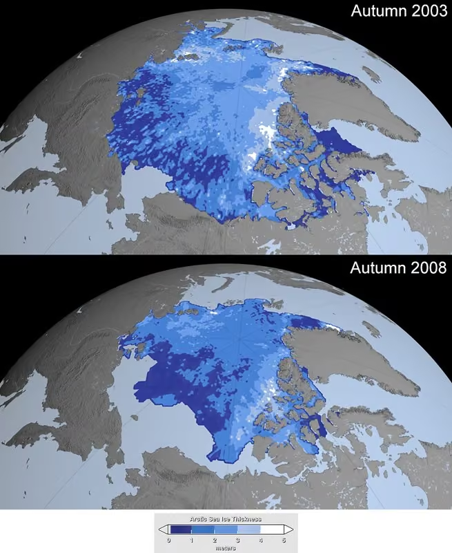
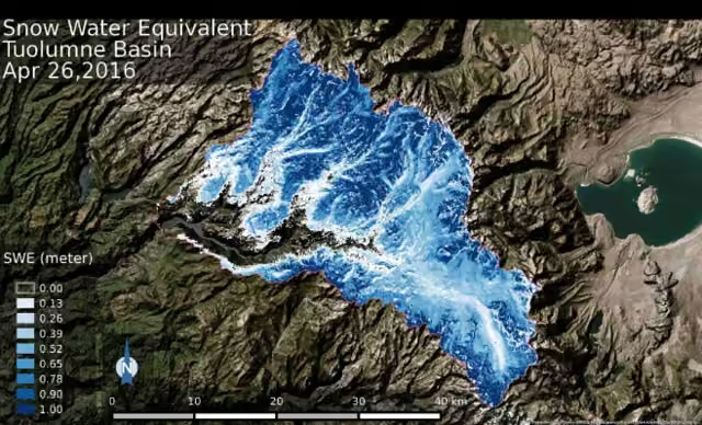
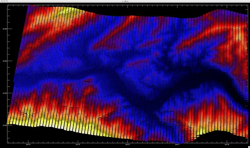
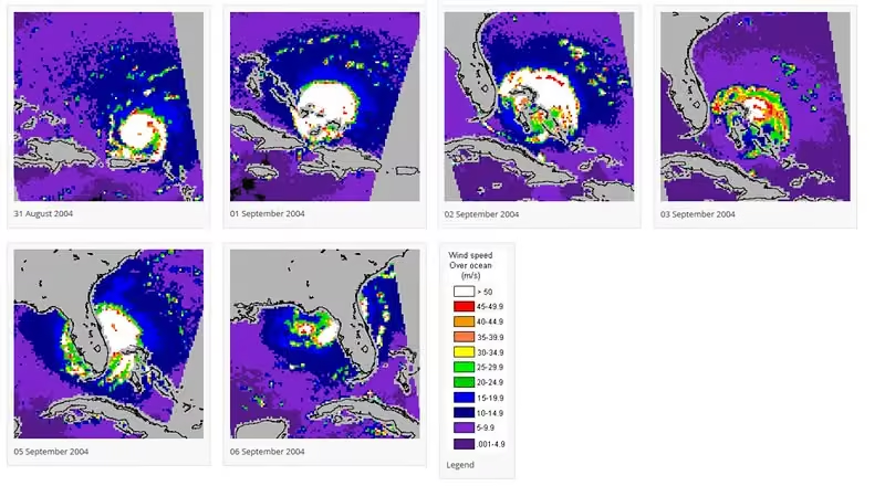
Arctic sea ice growth has been patchy following the minimum. In the Antarctic, ice cover is far below average in the Amundsen and Bellingshausen Seas, and low along the Indian Ocean. Read more on NSIDC's Sea Ice Today site: nsidc.org/sea-ice-today/analyses/arctic-and-antarctic-lif…
National Snow and Ice Data Center
The National Snow and Ice Data Center (NSIDC) is a United States information and referral center in support of polar and cryospheric research. NSIDC archives and distributes digital and analog snow and ice data and also maintains information about snow cover, avalanches, glaciers, ice sheets, freshwater ice, sea ice, ground ice, permafrost, atmospheric ice, paleoglaciology, and ice cores. More on Wikipedia
-
National Snow and Ice Data Center
@NSIDC

-
National Snow and Ice Data Center
@NSIDC
These snow observations were collected at 1,345 sites in the Soviet Union between 1966-1990; over 200 sites were sampled between 1991-1996. This NOAA@NSIDC data set holds 10-day average station snow depth data and spatially averaged transect observations. nsidc.org/data/g01170/versions/1
-
National Snow and Ice Data Center
@NSIDC
The new QGreenland website has been officially launched with a new style and feel. The educational resources (Teach tab) have been put into a standardized template to better skim and understand the potential use of resource in your teaching plans. qgreenland.org
-
National Snow and Ice Data Center
@NSIDC
Gangotri Glacier is one of the Himalaya’s biggest glaciers, some 30 kilometers (20 miles) long. Sandip Sengupta snapped this photo on October 1, 2008. This photo is just one of thousands available from NOAA@NSIDC’s Glacier Photograph Collection: nsidc.org/data/glacier_photo/
-
National Snow and Ice Data Center
@NSIDC
If your car window glass is clean, ice crystals branch out like plant fronds, called fern frost. If it is dirty, every speck of dust triggers an ice crystal; hundreds crowd into a grainy sheet of hoar frost. Search terms in the NSIDC cryosphere glossary: nsidc.org/learn/cryosphere-glossary
-
National Snow and Ice Data Center
@NSIDC
NASA Moderate Resolution Imaging Spectroradiometer (MODIS) sensors have functioned well for decades. What comes next? Visible Infrared Imaging Radiometer Suite (VIIRS)! Data sets are available from the NASA NSIDC DAAC. nsidc.org/data/viirs
-
National Snow and Ice Data Center
@NSIDC
See how researchers cooked up collaborative resources on how to use the the NASA Earthdata Cloud. nsidc.org/news-analyses/news-stories/cooking-collaborativ…
-
National Snow and Ice Data Center
@NSIDC
Stay informed with updates from NSIDC and our programs—NASA NSIDC Distributed Active Archive Center (DAAC), National Oceanic & Atmospheric Administration (NOAA@NSIDC), and the Exchange for Local Observations and Knowledge of the Arctic (ELOKA). Subscribe: nsidc.us12.list-manage.com/subscribe?u=3eed3adeb8ad095062…
-
National Snow and Ice Data Center
@NSIDC
Growing crops means understanding soil moisture, and the NASA NSIDC Distributed Active Archive Center (DAAC) has data for that. nsidc.org/news-analyses/news-stories/sensing-soil-moistur…
-
National Snow and Ice Data Center
@NSIDC
The continuous satellite record for Arctic sea ice monitoring started in late October 1978, but rescued Nimbus data sets, available from the NASA NSIDC DAAC, go back to the 1960s. nsidc.org/data/nimbus
-
National Snow and Ice Data Center
@NSIDC
Can you drink melted sea ice? Find the answer to this question and other questions about sea ice in NSIDC's Learn section of our website. nsidc.org/learn/parts-cryosphere/sea-ice/quick-facts-abou…
-
National Snow and Ice Data Center
@NSIDC
Want to view NASA NSIDC DAAC data through your browser? NASA Worldview makes it easy. worldview.earthdata.nasa.gov
-
National Snow and Ice Data Center
@NSIDC
The NASA NSIDC DAAC Making Earth System Data Records for Use in Research Environments (MEaSUREs) data collection includes data products derived from satellite data and created by researchers for researchers. nsidc.org/data/measures
-
National Snow and Ice Data Center
@NSIDC
Have you used the NSIDC DAAC's Satellite Observations of Arctic Change (SOAC) tool? If so, share your experience with us at nsidc@nsidc.org, to help us develop future capabilities that better support your data discovery and visualization requirements. nsidc.org/data/soac
-
National Snow and Ice Data Center
@NSIDC
The ICESat-2 Calibration/Validation Land, Vegetation, and Ice Sensor (LVIS) L3A Sea Ice Freeboard from the NASA NSIDC DAAC has high-resolution sea ice freeboard estimates from airborne measurements collected over the Arctic Ocean. nsidc.org/data/IS2LVIS3ACV/versions/1
-
National Snow and Ice Data Center
@NSIDC
NOAA@NSIDC has released Version 2 of the Canadian Ice Service Arctic Regional Sea Ice Charts in SIGRID-3 Format for ice concentration, development stage, & ice form. This version extends the data record from 2006 to 1968 through the present. nsidc.org/data/user-resources/data-announcements/new-vers…
-
National Snow and Ice Data Center
@NSIDC
The NASA NSIDC DAAC has released the SnowEx23 Oct23 IOP Snow Pits and Substrate Conditions at Freeze Up data set. It has snow pit measurements collected during the NASA SnowEx October 2023 Intensive Observation Period in Alaska. doi.org/10.5067/UHPAQGYY36W6
-
National Snow and Ice Data Center
@NSIDC
The NASA NSIDC DAAC ICESat/GLAS collection has data products derived from the Geoscience Laser Altimeter System (GLAS) instrument, from 2003 to early 2010. Parameters include sea ice, glacier, and ice sheet elevation, ice roughness, and more. nsidc.org/data/icesat
-
National Snow and Ice Data Center
@NSIDC
The Extreme Ice Survey Glacier Image Archive at NSIDC holds 1.5 million images from time-lapse cameras (2007-2022), capturing rapid changes in arctic and alpine landscapes. This collection provides crucial data on the speed and extent of glacial retreat. nsidc.org/data/nsidc-0783/versions/1
-
National Snow and Ice Data Center
@NSIDC
Display browse images from five different NOAA@NSIDC Arctic sea ice products in a spreadsheet-like format. The tool allows you to quickly compare different time periods and regions in a tabular view. Check it out: nsidc.org/data/bist
-
National Snow and Ice Data Center
@NSIDC
The Global Land Ice Measurements from Space (GLIMS) Glacier Viewer from the NASA NSIDC DAAC lets you compare glacier outlines from versions 6 and 7 of the Randolph Glacier Inventory. www.glims.org/maps/glims
-
National Snow and Ice Data Center
@NSIDC
Summer was cool and stormy over the Arctic Ocean. The Arctic sea ice extent average for September was thirteenth lowest in the satellite record. Antarctic sea ice extent dropped sharply through September, hitting record-low daily extents since October 2. nsidc.org/sea-ice-today/analyses/stranger-things-2026-arctic
-
National Snow and Ice Data Center
@NSIDC
A new study from NSIDC research affiliate Alia Khan shows that penguin poop, a light-absorbing shade of green, melts snow. The penguin poop fertilizes snow algae blooms, and as temperatures rise, snow-algae habitats spread, darkening the snow surface. news.agu.org/press-release/penguin-poop-is-melting-antarc…
-
National Snow and Ice Data Center
@NSIDC
Getting started with earthaccess? The NASA NSIDC Distributed Active Archive Center has got you covered. nsidc.org/data/user-resources/help-center/downloading-nsi…
-
National Snow and Ice Data Center
@NSIDC
The NASA NSIDC DAAC has released the ICESat-2 Cal/Val 2022 L2 CHIR Green Wavelength Lidar Arctic Sea Ice Heights and Bathymetry data set. It has Arctic summer sea ice heights and bathymetry, and aims to evaluate positional accuracies of ATLAS measurements. doi.org/10.5067/1HQSJWJGKWDL
-
National Snow and Ice Data Center
@NSIDC
Millions of people rely on water from melted snow. NASA's Advanced Microwave Scanning Radiometer for EOS (AMSR-E)/AMSR2 Unified L3 Global Monthly 25 km EASE-Grid Snow Water Equivalent from the NSIDC DAAC provides monthly estimates of snow water content. doi.org/10.5067/43NH9LHM9YRK
-
National Snow and Ice Data Center
@NSIDC
William O. Field photographed Alaska's Columbia Glacier’s front on Sept 11, 1931. Since 1980, the glacier retreated more than 20 km (12 miles), losing more than half its pre-1980 volume. See thousands of images from NOAA@NSIDC’s Glacier Photo Collection. nsidc.org/data/glacier_photo/
-
National Snow and Ice Data Center
@NSIDC
What types of data does NSIDC provide? Learn the answer to this question and more about our data: nsidc.org/data/user-resources/get-started-nsidc-data
-
National Snow and Ice Data Center
@NSIDC
As sea levels rise and global topography changes, coastal communities may increasingly need to plan for relocation. But Alaska’s threatened communities have demonstrated the challenge of relocation. nsidc.org/news-analyses/news-stories/see-or-not-see-reali…
-
National Snow and Ice Data Center
@NSIDC
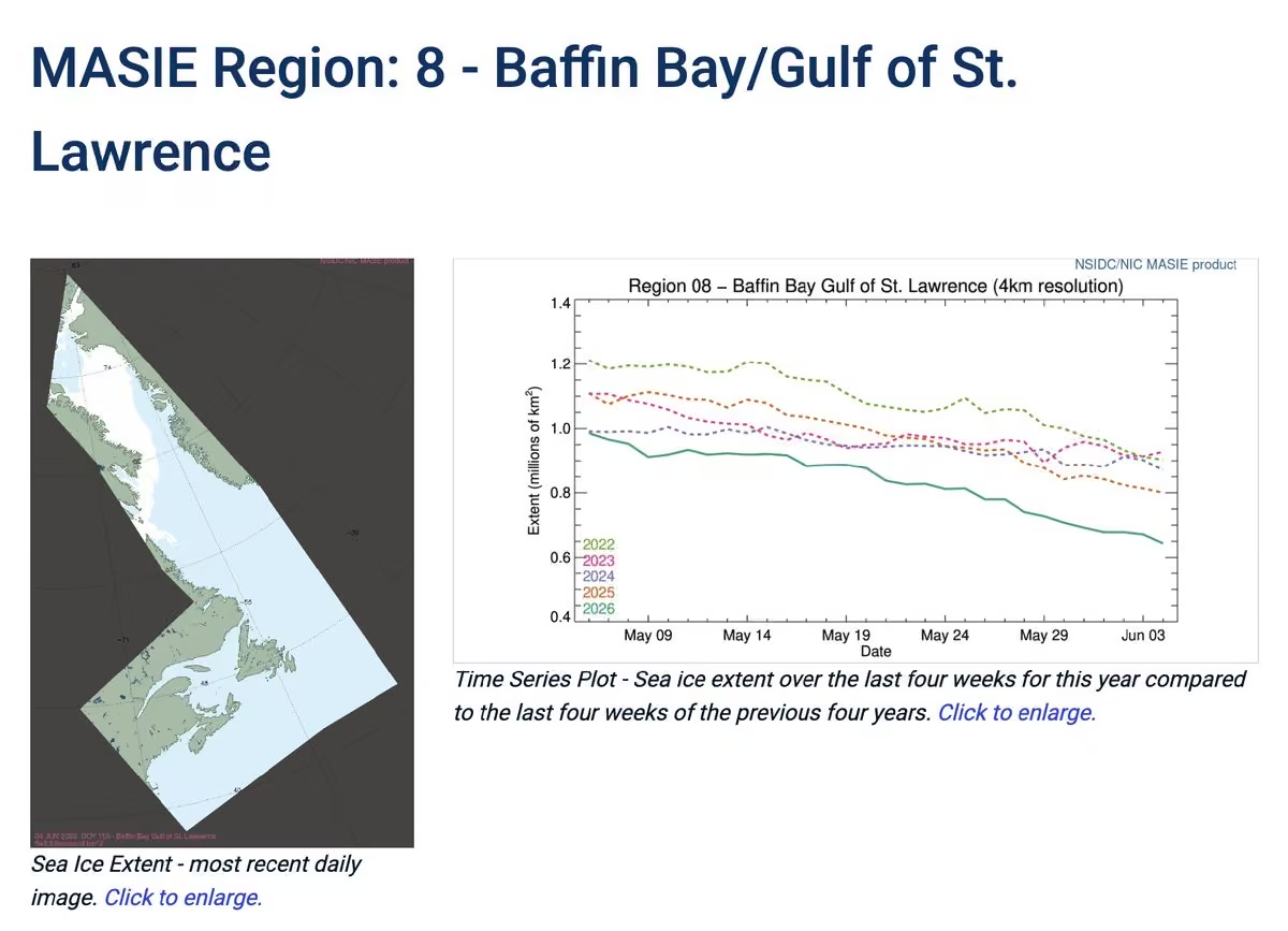
Use the NOAA@NSIDC Multisensor Analyzed Sea Ice Extent-Northern Hemisphere (MASIE-NH) data product to select and view an Arctic region's recent ice extent. Compare this year's extent over the last four weeks with the previous four years for the same time: nsidc.org/data/masie/explore-region
-
National Snow and Ice Data Center
@NSIDC
Don't miss out on the NSIDC monthly newsletter. Subscribe here: nsidc.us12.list-manage.com/subscribe?u=3eed3adeb8ad095062…
-
National Snow and Ice Data Center
@NSIDC
Arctic sea ice extent has reached its minimum for the year, landing at 10th lowest with 2008, 2010, and 2025. Antarctic sea ice may have topped out at 3rd lowest maximum in the satellite record. A full analysis will come out in early Oct from Sea Ice Today:nsidc.org/news-analyses/news-stories/arctic-sea-ice-has-r…
-
National Snow and Ice Data Center
@NSIDC
On Sept 12, Arctic sea ice reached its annual minimum extent of 4.60 million square kilometers (1.78 million square miles), tying for tenth lowest with 2008, 2010, and 2025. The last 20 years are the lowest 20 sea ice extents in the satellite record. nsidc.org/sea-ice-today/analyses/arctic-sea-ice-minimum-t…
-
National Snow and Ice Data Center
@NSIDC
This year, NSIDC celebrates 50 years of data, research, and service. In 1976, the United States celebrated its bicentennial, disco topped the charts, and no one had yet seen a Star Wars movie. That same year, the NSIDC opened its doors. nsidc.org/news-analyses/news-stories/nsidc-turns-50
-
National Snow and Ice Data Center
@NSIDC
Nilas is a thin sheet of smooth, level ice less than 10 centimeters (4 inches) thick. It is the first stage in sea ice growth, forming in calm, cold conditions with a dark, almost translucent appearance. Learn more cool terms: NSIDC cryosphere glossary nsidc.org/learn/cryosphere-glossary?name=nila&exposed_for…
-
National Snow and Ice Data Center
@NSIDC
NOAA@NSIDC is a collaborative program between the National Oceanic and Atmospheric Administration and the National Snow and Ice Data Center that provides free, open-access data on Earth's frozen regions. nsidc.org/data/data-programs/noaa-nsidc
-
National Snow and Ice Data Center
@NSIDC
The complete multichannel passive microwave record includes sea ice observations from late Oct 1978 to today using the NASA NSIDC DAAC Scanning Multichannel Microwave Radiometer (SMMR), SSM/I, SSMIS, and Advanced Microwave Scanning Radiometer (AMSR2). nsidc.org/data/smmr_ssmi
-
National Snow and Ice Data Center
@NSIDC
You have multiple options to download data from the Moderate Resolution Imaging Spectroradiometer (MODIS), archived at the NSIDC Distributed Active Archive Center (DAAC), including NASA Earthdata search and Worldview. nsidc.org/data/modis
-
National Snow and Ice Data Center
@NSIDC
The Ice, Cloud and Elevation Satellite-2 (ICESat-2) L4 Monthly Gridded Sea Ice Thickness, Version 4 data set, available from the NASA NSIDC DAAC, now offers extended temporal coverage with monthly files from September 2025 through April 2026. doi.org/10.5067/TXDHDJ1JT0CG
-
National Snow and Ice Data Center
@NSIDC
In 2021, the US NSF established the NNA Community Office (NNA-CO) at NSIDC for its Navigating the New Arctic program to coordinate 100+ projects, build lasting partnerships, and offer resources and opportunities for knowledge exchange across the Arctic. nsidc.org/news-analyses/news-stories/navigating-new-ways-…
-
National Snow and Ice Data Center
@NSIDC
Data products from the NASA NSIDC DAAC Advanced Microwave Scanning Radiometer for EOS (AMSR-E): sea ice concentration & motion, sea surface temp, snow depth & water equivalent, soil moisture, wind speed, water vapor, precipitation, and other parameters. nsidc.org/data/amsre
-
National Snow and Ice Data Center
@NSIDC
Do you know how to access data from the NASA NSIDC Distributed Active Archive Center (DAAC) Earthdata Cloud? We can get you started. nsidc.org/data/earthdata-cloud
-
National Snow and Ice Data Center
@NSIDC
Although conditions are harsh at the poles, life thrives above, below, and within sea ice, which is critical to sustaining migratory birds, fish, and other species by fulfilling fundamental functions in life's seasonal rhythm. Learn more about sea ice: nsidc.org/learn/parts-cryosphere/sea-ice/why-sea-ice-matters
-
National Snow and Ice Data Center
@NSIDC
High Mountain Asia has the highest concentration of glacier ice outside the polar regions. Glaciers provide life-sustaining water but pose hazards such as glacial-lake outburst floods and landslides. The NSIDC DAAC offers myriad data sets on this region. nsidc.org/data/highmountainasia
-
National Snow and Ice Data Center
@NSIDC
Explore over 1,400 data sets housed at NSIDC. Filter results by collection method, geographic area, and geophysical measurement. nsidc.org/data/explore-data
-
National Snow and Ice Data Center
@NSIDC
NOAA@NSIDC's data set called "Sea-ice Thickness and Draft Statistics from Submarine ULS, Moored ULS, and a Coupled Model" offers sea ice thickness and draft estimates from multiple observations around the North Pole from Jan 1, 1979, to Dec 31, 2004. doi.org/10.7265/N53N21BT
-
National Snow and Ice Data Center
@NSIDC
A small lake of meltwater can pool near a glacier's terminus. But extreme or fast ice melt, or ice or rock avalanches into these lakes, can cause water to overflow. These glacial lake outburst floods can be rapid and deadly. Learn more about glaciers: nsidc.org/learn/parts-cryosphere/glaciers
-
National Snow and Ice Data Center
@NSIDC
Two NSIDC DAAC data sets, Soil Moisture Ocean Salinity (SMOS)-Based Soil Moisture Active Passive (SMAP) L2 Radiometer Half-Orbit 9 km EASE-Grid Soil Moisture and SMAP/SMOS L3 Radiometer 9 km EASE-Grid Soil Moisture, have been updated to version 2. nsidc.org/data/user-resources/data-announcements/data-set…
-
National Snow and Ice Data Center
@NSIDC
The Exchange for Local Observations and Knowledge of the Arctic, a NSIDC program, collaborates with Arctic communities and Indigenous organizations, schools, and researchers to create customized data management products and open and tailored data access. eloka.nsidc.org/eloka
-
National Snow and Ice Data Center
@NSIDC
NSIDC's monthly sea ice analyses are back! In the Arctic, the sea ice extent this summer was tracking 2012 levels until August. In the Antarctic, sea ice had an unusually large mid-winter decline over a week in August. nsidc.org/sea-ice-today/analyses/arctic-zigs-antarctic-zags
-
National Snow and Ice Data Center
@NSIDC
FAIR = Findable, Accessible, Interoperable, Reproducible. OpenScapes helps NSIDC achieve those data-access goals. nsidc.org/news-analyses/news-stories/using-nasa-openscape…
-
National Snow and Ice Data Center
@NSIDC
The NSIDC DAAC has released a new data set: SnowEx23 Airborne SWESARR Backscatter Intensity Raw. It contains airborne microwave observations collected during the SnowEx23 Alaska field campaign. nsidc.org/data/user-resources/data-announcements/new-data…
-
National Snow and Ice Data Center
@NSIDC
You can view NSIDC data on a virtual globe using our Google Earth files, including sea ice minimum and maximim extents dating back to 1979. nsidc.org/data/google_earth
-
National Snow and Ice Data Center
@NSIDC
The Aquarius data collection from the NSIDC Distributed Active Archive Center (DAAC) offers daily, monthly, seasonal, and annual soil moisture products, along with salinity and freeze/thaw products. nsidc.org/data/aquarius/data
-
National Snow and Ice Data Center
@NSIDC
A nunatak is a rocky crag or small mountain projecting from and surrounded by a glacier or ice sheet. Visit the NSIDC Cryosphere Glossary to discover more unique terms that describe our frozen world. nsidc.org/learn/cryosphere-glossary
-
National Snow and Ice Data Center
@NSIDC
NOAA@NSIDC offers 100+ data sets, including current and historical sea ice conditions, decades-long snow records, historic glacier photos, atlases made with international collaborations, even declassified Cold War submarine observations of the Arctic. nsidc.org/data/data-programs/noaa-nsidc
-
National Snow and Ice Data Center
@NSIDC
The NSIDC DAAC Advanced Microwave Scanning Radiometer Unified (AMSRU) collection offers passive microwave data products on snow, sea ice, soil moisture, vegetation water content, and brightness temperature. nsidc.org/data/amsru
-
National Snow and Ice Data Center
@NSIDC
Fox Glacier is New Zealand’s third-largest glacier. Its low altitude and accessibility make Fox Glacier a major tourist attraction, but as the glacier shrinks, rockfalls are a major threat. See more from the NOAA@NSIDC’s Glacier Photograph Collection. nsidc.org/data/glacier_photo/
-
National Snow and Ice Data Center
@NSIDC
The NSIDC DAAC has released a new data set: High Mountain Asia Moderate Resolution Imaging Spectroradiometer (MODIS)/Terra L3 Daily 500m SIN Grid Spatially and Temporally Complete (STC) Snow Cover and Snow Surface Properties. nsidc.org/data/user-resources/data-announcements/new-data…
-
National Snow and Ice Data Center
@NSIDC
Subscribe to the NSIDC monthly newsletter to get updates on our work and impact. nsidc.us12.list-manage.com/subscribe?u=3eed3adeb8ad095062…
-
National Snow and Ice Data Center
@NSIDC
NSIDC lead scientist John Cassano is en route to Antarctica for his sixteenth field campaign. As with previous fieldwork, Cassano plans to blog once or twice a week, focusing on what he is doing and what living and working in Antarctica is like. ciresblogs.colorado.edu/antarcticuavs/
-
National Snow and Ice Data Center
@NSIDC
Check out the latest version of Making Earth System Data Records for Use in Research Environments (MEaSUREs) for Greenland 6 and 12 day Ice Sheet Velocity Mosaics from SAR data set, available from the NSIDC DAAC. nsidc.org/data/user-resources/data-announcements/data-set…
-
National Snow and Ice Data Center
@NSIDC
You can use OpenAltimetry to find data from the Ice, Cloud and Elevation Satellite (ICESat) and ICESat-2 for the Arctic, Antarctic, and places in between. Data are available from the NSIDC Distributed Active Archive Center (DAAC). openaltimetry.earthdatacloud.nasa.gov/data/
-
National Snow and Ice Data Center
@NSIDC
Getting started with NASA's Earthdata Cloud? We've got you covered. nsidc.org/data/user-resources/help-center/nasa-earthdata-…
-
National Snow and Ice Data Center
@NSIDC
Check out the rich assortment of Moderate Resolution Imaging Spectroradiometer (MODIS) snow and sea ice products available from the NSIDC Distributed Active Archive Center. nsidc.org/data/modis
-
National Snow and Ice Data Center
@NSIDC
The NSIDC DAAC has just released the Ice, Cloud and Elevation Satellite-2 Calibration/Validation Land, Vegetation, and Ice Sensor (LVIS) L3A Sea Ice Freeboard data set, with estimates derived from airborne measurements. nsidc.org/data/user-resources/data-announcements/new-data…
-
National Snow and Ice Data Center
@NSIDC
The daily Sea Ice Index provides a quick look at Arctic and Antarctic changes in sea ice. It provides consistently processed daily ice extent and concentration images and data since 1979. Check out our rich archive: nsidc.org/data/seaice_index
-
National Snow and Ice Data Center
@NSIDC
Tune in on Aug. 26, 2026, at 2:30-3:15 p.m. EDT for a tutorial on Using the earthaccess Python Library to Stream Data. NSIDC's Andrew Barrett will present. www.earthdata.nasa.gov/events/using-earthaccess-python-li…
-
National Snow and Ice Data Center
@NSIDC
The NSIDC DAAC Global Land Ice Measurements from Space (GLIMS) collection includes data from approximately 70 percent of the world's roughly 200,000 glaciers, and new glaciers are continually being added. nsidc.org/data/glims
-
National Snow and Ice Data Center
@NSIDC
Join the Aug 26 webinar on how to use the Python earthaccess library to stream NASA data directly to memory, skipping the download. Presenters will demonstrate the difference between downloading and streaming data using the NASA Merra-2 reanalysis product. www.earthdata.nasa.gov/events/using-earthaccess-python-li…
-
National Snow and Ice Data Center
@NSIDC
With the generous support of the Climate Science and Communication Fund from Surge Climate Talent, NSIDC’s Ice Sheets and Sea Ice News and Analysis (ISSINA) program is able to start up monthly science assessments for the Sea Ice Today site. Stay tuned: nsidc.org/sea-ice-today/analyses/nsidcs-analysis-site-sea…
-
National Snow and Ice Data Center
@NSIDC
Did you know you could click on the timeline on NSIDC's Charctic graph? When you do, a map of sea ice extent pops up for that date? Watch this short video and see how easy it is. It shows where Antarctic sea ice retreated between August 7 and 11.
-
National Snow and Ice Data Center
@NSIDC
The Nunatsiavut Sea Ice Observer Program (NSIOP) collaborated with the Exchange for Local Observations and Knowledge of the Arctic (ELOKA), a program at NSDIC, to create an observational database of sea ice conditions off of northeastern Labrador, Canada. eloka.nsidc.org/our-work/stories-events/reading-ice-inuit…
-
National Snow and Ice Data Center
@NSIDC
The NASA NSIDC DAAC Data Access Tool can be used to search and filter data files for NSIDC DAAC data sets using a map-based interface. Once you've made your selection, there are multiple options for how to access the data you have selected. nsidc.org/data/data-access-tool
-
National Snow and Ice Data Center
@NSIDC
Don't miss out on NSIDC updates in our monthly newsletter with highlights from our three programs: NASA NSIDC Distributed Active Archive Center, NOAA@NSIDC, and the Exchange for Local Observations and Knowledge of the Arctic (ELOKA). Sign up here: nsidc.us12.list-manage.com/subscribe?u=3eed3adeb8ad095062…
-
National Snow and Ice Data Center
@NSIDC
Have you used the NASA NSIDC DAAC's Satellite Observations of Arctic Change (SOAC) tool? If so, share your experience with us at nsidc@nsidc.org, to help us develop future capabilities that better support data discovery and visualization requirements. nsidc.org/data/soac
-
National Snow and Ice Data Center
@NSIDC
NASA NSIDC DAAC has released a new data set: Ice, Cloud and Elevation Satellite (ICESat)/ICESat-2 Traverse: Monthly GPS Surface Elevation Data at Summit Station, Greenland. It contains terrain data along a defined survey transect west of Summit Station. nsidc.org/data/IS2TGPSSS/versions/1
-
National Snow and Ice Data Center
@NSIDC
One of NSIDC's three programs, NOAA@NSIDC, offers the Multisensor Analyzed Sea Ice Extent-Northern Hemisphere (MASIE-NH) data set. See Arctic sea ice now and download a map archive dating back to 2006. nsidc.org/data/masie
-
National Snow and Ice Data Center
@NSIDC
Have a question about accessing NASA NSIDC Distributed Active Archive Center (DAAC) data from the NASA Earthdata Cloud? We've got answers! nsidc.org/data/earthdata-cloud/help-articles
-
National Snow and Ice Data Center
@NSIDC
A lead is a long, linear area of open water that ranges from a few meters to over a kilometer in width, and tens of kilometers long; they develop as ice diverges, or pulls apart. See other crysopheric terms in the NSIDC glossary: nsidc.org/learn/cryosphere-glossary?name=lead&exposed_for…
-
National Snow and Ice Data Center
@NSIDC
The Advanced Microwave Scanning Radiometer (AMSR-E) data sets, available from NASA NSIDC DAAC, include brightness temperature, sea ice concentration & motion, precipitation, snow depth, snow water equivalent, soil moisture, and vegetation water content. nsidc.org/data/amsre
-
National Snow and Ice Data Center
@NSIDC
The NASA NSIDC DAAC has released a new version of the Advanced Topographic Laser Altimeter System (ATLAS)/ICESat-2 L3B Gridded Sea Ice Freeboard Quick Look data set, with rolling 30-day gridded estimates of sea ice freeboard. nsidc.org/data/atl20ql/versions/5
-
National Snow and Ice Data Center
@NSIDC
The peak melt season for Arctic sea ice occurs in summer, with ice cover reaching its lowest point in September. July is historically the warmest month in the Arctic with the highest volume of ice loss. See current conditions with NSIDC's Chartic graph: nsidc.org/sea-ice-today/sea-ice-tools/charctic-interactiv…
-
National Snow and Ice Data Center
@NSIDC
The continuous satellite record of polar sea ice started in October 1978, but the NASA NSIDC Distributed Active Archive Center (DAAC) Nimbus Rescue Project extended the non-continuous data record back to 1964. nsidc.org/data/nimbus
-
National Snow and Ice Data Center
@NSIDC
Learn how to download and visualize NASA NSIDC Distributed Active Archive Center (DAAC) products through NASA Worldview. nsidc.org/data/user-resources/help-center/visualize-and-d…
-
National Snow and Ice Data Center
@NSIDC
This glacier inventory from NOAA@NSIDC of West Greenland includes 5,297 glaciers from 1948 to 1985, taken from 1:250,000 maps, Landsat imagery, and aerial photographs. Data records include latitude and longitude, min and max elevation, and surface area. nsidc.org/data/g01375/versions/1
-
National Snow and Ice Data Center
@NSIDC
The Larsen B Ice Shelf on the Antarctic Peninsula lost the size of Rhode Island in sea ice in the 2002. After, glaciers feeding the shelf flowed faster. When stable, ice shelves act as brakes. When lifted, glaciers accelerate & land ice melts into the sea. nsidc.org/learn/parts-cryosphere/ice-shelves
-
National Snow and Ice Data Center
@NSIDC
The NASA NSIDC Distributed Active Archive Center data collection from the Moderate Resolution Imaging Spectroradiometer (MODIS) includes snow cover and sea ice data products derived from NASA’s MODIS instruments aboard both the Terra and Aqua satellites. nsidc.org/data/modis
-
National Snow and Ice Data Center
@NSIDC
Want to simplify downloading Earthdata cloud data? Then earthaccess can help. nsidc.org/data/user-resources/help-center/downloading-nsi…
-
National Snow and Ice Data Center
@NSIDC
The NASA NSIDC Distributed Active Archive Center (DAAC) Land, Vegetation, and Ice Sensor (LVIS) collection has data on surface topography of oceans, land, glaciers, ice sheets, and sea ice; and vegetation and structural heights. nsidc.org/data/lvis
-
National Snow and Ice Data Center
@NSIDC
High Mountain Asia 5 Arc-Minute Hydrological Flow Direction for the Headwaters of the Amu Darya and Indus River Basins, available from the NASA NSIDC Distributed Active Archive Center (DAAC), has data readings spanning four countries. doi.org/10.5067/SE4AJ5NZBWT5
-
National Snow and Ice Data Center
@NSIDC
Whether it rains or snows, the Advanced Microwave Scanning Radiometer for EOS (AMSR-E)/AMSR2 Unified L2B Global Swath Surface Precipitation at the NASA NSIDC Distributed Active Archive Center reports instantaneous surface precipitation rates and types. nsidc.org/data/AU_Rain/versions/1
-
National Snow and Ice Data Center
@NSIDC
Join Webinar on Updating the Researcher’s Toolkit: Policy Engagement for a Changing Funding Landscape on July 9, 2026, at 2 PM ET. Learn how to engage policymakers, communicate research impact, and navigate a changing funding environment. Register: iarpc.zoom.us/saml/login?_x_zm_rtaid=4vq2D90UQ66uiY26Ks2M…...
-
National Snow and Ice Data Center
@NSIDC
Snow Today is a NASA-funded research project at NSIDC that examines where snow is present, where it has snowed recently, and how much water is in the snow, while also comparing between snow today, yesterday, last year, and over the last few decades. nsidc.org/snow-today
-
National Snow and Ice Data Center
@NSIDC
Remember Chasing Ice? The 2012 film about James Balog's photo project captured the subzero logistics of maintaining cameras in places like Greenland. Now over 1.5 million time-lapse images are at NSIDC, allowing free access to see global glacial retreat. nsidc.org/data/nsidc-0783/versions/1
-
National Snow and Ice Data Center
@NSIDC
NASA is decommissioning Moderate Resolution Spectroradiometer (MODIS) sensors and shifting to the Visible Infrared Imaging Radiometer Suite (VIIRS) sensor. The NSIDC analysis site Snow Today is converting to VIIRS data this year. nsidc.org/snow-today/about-snow-today
-
National Snow and Ice Data Center
@NSIDC
The Nunatsiavut Sea Ice Observer Program (NSIOP) collaborated with the Exchange for Local Observations and Knowledge of the Arctic (ELOKA), a program at NSIDC, to create an observational database of sea ice conditions in coastal Labrador, Canada. eloka.nsidc.org/our-work/stories-events/reading-ice-inuit…
-
National Snow and Ice Data Center
@NSIDC
Want to receive a monthly summary of the biggest NSIDC news at the beginning of each month? Sign up for our newsletter. nsidc.us12.list-manage.com/subscribe?u=3eed3adeb8ad095062…
-
National Snow and Ice Data Center
@NSIDC
The Athabasca Glacier in Canada is one of the most accessible and visited glaciers in the world. As such, its retreat is well documented, rendering glacial change apparent. Explore this glacier and others with NSIDC's Glacier Photograph Collection: nsidc.org/data/glacier_photo/search/
-
National Snow and Ice Data Center
@NSIDC
The Soil Moisture Active Passive (SMAP)/Sentinel-1 L2 Radiometer/Radar 30-Second Scene 3 km Equal-Area Scalable Earth (EASE-Grid) Soil Moisture provides coverage from 60°N to 60°S from March 31, 2015 on. Data are available from the @NASA NSIDC DAAC. nsidc.org/data/SPL2SMAP_S/versions/3
-
National Snow and Ice Data Center
@NSIDC
One of NSIDC's oldest data sets is from the NOAA@NSIDC program: The Global Lake and River Ice Phenology Database contains freeze and breakup dates for 865 lakes and rivers around the world. The earliest record is for Lake Constance in Germany, from 874. nsidc.org/data/g01377/versions/1
-
National Snow and Ice Data Center
@NSIDC
SnowEx data sets at the @NASA NSIDC Distributed Active Archive Center (DAAC) include a wealth of snow pit measurements—but not just those. SnowEx data also include brightness temperatures, radar reflectivity, lidar, radar cross-sections. nsidc.org/data/snowex
-
National Snow and Ice Data Center
@NSIDC
Explore NSIDC's web services, interactive tutorials, and other tools to access and work with data from our three programs: NOAA@NSIDC, the NASA NSIDC DAAC, and the Exchange for Local Observations and Knowledge of the Arctic (ELOKA): nsidc.org/data/user-resources/data-tools
-
National Snow and Ice Data Center
@NSIDC
The NOAA@NSIDC program leverages NSIDC-wide expertise in scientific analysis, data curation, quality assurance, and technical communication when archiving, developing, and publishing data products. Learn more about the program and its unique data sets: nsidc.org/data/data-programs/noaa-nsidc/about-noaansidc
-
National Snow and Ice Data Center
@NSIDC
Check out Greenland ice velocity maps, available from the @NASA NSIDC Distributed Active Archive Center (DAAC) as part of the Making Earth System Data Records for Use in Research Environments (MEaSUREs) project. nsidc.org/grimp
-
National Snow and Ice Data Center
@NSIDC
The Ice Edge Positions in the Nordic Seas data product from NOAA@NSIDC contains ice edge coordinates from March to August, 1750-2002. Data are derived from sea ice products and observational ship logbooks, diaries, and recent satellite data: nsidc.org/data/g02169/versions/1
-
National Snow and Ice Data Center
@NSIDC
ATLAS/ICESat-2 L3B Gridded Antarctic and Arctic Land Ice Height Change, available from the @NASA NSIDC Distributed Active Archive Center, shows how land ice height has changed over time. doi.org/10.5067/ATLAS/ATL15.004
-
National Snow and Ice Data Center
@NSIDC
Grease ice makes the water resemble an oil slick, the small crystals of ice held closely together reflect and refract light similarly to how oil will on water. Photo by Nina Munteanu. Find more terms of Earth's frozen region in NSIDC's glossary: nsidc.org/learn/cryosphere-glossary
-
National Snow and Ice Data Center
@NSIDC
Name three differences between Arctic and Antarctic sea ice. Find the answers in NSIDC's learn pages and why scientists focus more on Arctic sea ice: nsidc.org/learn/parts-cryosphere/sea-ice/quick-facts-abou…
-
National Snow and Ice Data Center
@NSIDC
Scientific data should be FAIR: Findable, Accessible, Interoperable, and Reproducible. Openscapes helps with that. Be inspired to collaborate on your research! nsidc.org/news-analyses/news-stories/using-nasa-openscape…
-
National Snow and Ice Data Center
@NSIDC
The Advanced Microwave Scanning Radiometer-Earth Observing System's (AMSR-E's) sensor can pierce clouds. Even in polar darkness it tracks sea ice changes year-round. AMSR-E data are available from the NASA NSIDC Distributed Active Archive Center (DAAC). nsidc.org/data/amsre
-
National Snow and Ice Data Center
@NSIDC
Zoom in or out as much as you like with the Global Land Ice Measurements from Space (GLIMS) Viewer. GLIMS data are distributed by the NASA NSIDC Distributed Active Archive Center (DAAC). www.glims.org/maps/glims
-
National Snow and Ice Data Center
@NSIDC
The National Oceanic and Atmospheric Administration at NSIDC (NOAA@NSIDC) program is one of the only places in the world that archives long-term records of Earth's frozen regions. See the most popular products: nsidc.org/data/data-programs/noaa-nsidc
-
National Snow and Ice Data Center
@NSIDC
Since 1917, Nenana, Alaska, has hosted a contest to predict when ice on the Tenana River breaks up come spring. A tripod, wired to an onshore clock, is planted during freeze up. The clock stops when the tripod moves. See the data at the NASA NSIDC DAAC: nsidc.org/data/nsidc-0064/versions/2.
-
National Snow and Ice Data Center
@NSIDC
Did you know that the NOAA Multisensor Analyzed Sea Ice Extent-Northern Hemisphere (MASIE-NH) offers daily images and times series plots for individual Arctic regions? Such as Baffin Bay, which has hit a record low since early May. Check out other regions: nsidc.org/data/masie/explore-region
-
National Snow and Ice Data Center
@NSIDC
With support from @NASA, the Snow International (SINTER) and CUHASI Snow Measurement Field School will take place in New Hampshire next year. Participants can apply later in summer 2026; learn more from last year's snow school: nsidc.org/sinter
-
National Snow and Ice Data Center
@NSIDC
The NSIDC monthly newsletter is due to come out shortly. Don't miss out. Sign up to learn more about NSIDC's research, data, and stories. nsidc.us12.list-manage.com/subscribe?u=3eed3adeb8ad095062…
-
National Snow and Ice Data Center
@NSIDC
Snow-covered area across the West was 49 percent of average for May, ranking last in the 26-year satellite record. Snow water equivalent remained well below average in most states, confirming a worrisome outlook for the summer. Read NSIDC's Snow Today: nsidc.org/snow-today/monthly-insights/no-snow-no-flow
-
National Snow and Ice Data Center
@NSIDC
The Extreme Ice Survey (EIS) images at NSIDC include over 1.5 million glacial photographs from 2007-2022, capturing time-lapse changes in arctic and alpine landscapes. This collection provides crucial data on the speed and extent of glacial retreat. www.youtube.com/watch?v=5wtlbhjcVho&t=52s
-
National Snow and Ice Data Center
@NSIDC
The NASA NSIDC Distributed Active Archive Center (DAAC) has updated Sea Ice Concentrations from Nimbus-7 Scanning Multichannel Microwave Radiometer (SMMR) and Defense Meteorological Satellite Program (DMSP) SSM/I-SSMIS Passive Microwave Data through 2025. nsidc.org/data/NSIDC-0051/versions/2
-
National Snow and Ice Data Center
@NSIDC
The Daily Great Lakes Ice Concentration data set consists of daily gridded ice concentrations from December 20, 1972, to May 21, 2023, as gridded ASCII text files with corresponding browse images and shapefiles also available since the 2003 ice season. nsidc.org/data/g10029/versions/1
-
National Snow and Ice Data Center
@NSIDC
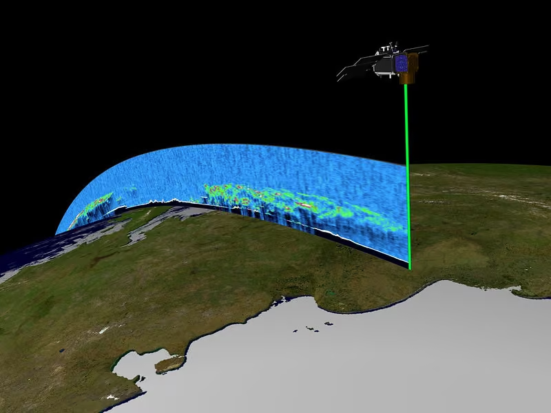
NASA's Advanced Topographic Laser Altimeter System (ATLAS) aboard Ice, Cloud and Elevation Satellite-2 (ICESat-2) employs three pairs of laser beams aimed at Earth’s surface, emitting 10,000 pulses per second, with 300 trillion photons per pulse. nsidc.org/news-analyses/news-stories/mission-and-support-…
-
National Snow and Ice Data Center
@NSIDC
NOAA's monthly Sea Ice Index shows changes in polar sea ice extent and concentration since 1979. The index also offers monthly images of differences from average in ice concentration: blue values indicate below the 1981-2010 average, red are above average. nsidc.org/data/seaice_index
-
National Snow and Ice Data Center
@NSIDC
High Mountain Asia has glaciers topped with debris topped with lakes, and you can find those lake extents at the NASA NSIDC Distributed Active Archive Center (DAAC). nsidc.org/data/HMA2_DCG_SGL/versions/1
-
National Snow and Ice Data Center
@NSIDC
Before satellites, scientists stitched together aerial photographs of big features, such as Greenland’s Jakobshavn Glacier. This composite image dates from 1970 and 1971 and is now available in the NSIDC Glacier Photograph Collection. nsidc.org/data/glacier_photo/
-
National Snow and Ice Data Center
@NSIDC
Take a climate change tour of the cryosphere with our Google Earth activities. nsidc.org/data/google_earth
-
National Snow and Ice Data Center
@NSIDC
The NSIDC Distributed Active Archive Center (DAAC) NASA Earthdata Cloud data collection includes all NSIDC DAAC data that have been migrated into the NASA Earthdata Cloud, which is a lot of data, enough to fill libraries. nsidc.org/data/earthdata-cloud
-
National Snow and Ice Data Center
@NSIDC
Arctic methane can come from thawing permafrost where once frozen dead plants and animals begin to decay, releasing the potent greenhouse gas. The other source, known as methyl clathrate, can be found in ice crystals. Learn more about permafrost: nsidc.org/learn/parts-cryosphere/frozen-ground-permafrost
-
National Snow and Ice Data Center
@NSIDC
Despite shrinking federal support for renewable energy, the green electricity revolution is happening in many states and globally. In this week’s show, KGNU host Susan Moran interviews Mark Serreze, director of the National Snow and Ice Data Center: howonearthradio.org/archives/10609
-
National Snow and Ice Data Center
@NSIDC
These penitents show no remorse. As striking snow formations—found at high altitudes like the Dry Andes—they form into tall blades of ice that lean toward the sun, resembling a group of repentant figures in hooded cloaks. For more from the NSIDC glossary: nsidc.org/learn/cryosphere-glossary
-
National Snow and Ice Data Center
@NSIDC
The Moderate Resolution Imaging Spectroradiometer (MODIS) Version 61 data sets, featuring global snow and sea ice data, have been updated. Data are available from the NASA NSIDC Distribute Active Archive Center (DAAC). nsidc.org/data/user-resources/data-announcements/user-not…
-
National Snow and Ice Data Center
@NSIDC
After stalling out for a few days in early May, Arctic sea ice extent is dropping again. Check out NSIDC's ChArctic graph tool to compare Arctic and Antarctic sea ice extent data for any year or combination of years from 1979 to present. nsidc.org/sea-ice-today/sea-ice-tools/charctic-interactiv…
-
National Snow and Ice Data Center
@NSIDC
Cooler weather brought snow to the Rocky Mountains on May 18. For the parched West, the storm helped move the average snow cover line graph to just barely above the West's all-time record low for the year. See NSIDC's Snow Today for more maps and data: nsidc.org/snow-today/snow-viewer
-
National Snow and Ice Data Center
@NSIDC
The Indigenous Pavilion first appeared at the 2025 Arctic Science Summit Week (ASSW) in Boulder, CO. Indigenous rights holders and researchers prioritized it for the 2026 ASSW conference in Denmark. Read reflections from NSIDC's ELOKA team member: eloka.nsidc.org/our-work/stories-events/reflections-arcti…
-
National Snow and Ice Data Center
@NSIDC
Need soil moisture data? Aquarius has that. Need freeze/thaw data? Aquarius has that, too. Data from its microwave radiometers and scatterometer are available from the NASA NSIDC Distributed Active Archive Center. doi.org/10.5067/OV4R18NL3BQR
-
National Snow and Ice Data Center
@NSIDC
The NASA Advanced Microwave Scanning Radiometer Unified (AMSRU) collection from the NSIDC DAAC includes brightness temperature, sea ice concentration & motion, precipitation, snow depth, snow water equivalent, soil moisture, and vegetation water content. nsidc.org/data/amsru
-
National Snow and Ice Data Center
@NSIDC
NASA’s OpenAltimetry is a free, powerful map-based data visualization and discovery tool for exploring surface elevation profiles from the Ice, Cloud and Elevation Satellite (ICESat) and ICESat-2 mission altimetry data. nsidc.org/openaltimetry
-
National Snow and Ice Data Center
@NSIDC
The NOAA@NSIDC program offers over 100 open-access data sets about current and historical sea ice conditions, decades-long records of snow extent, historic glacier photographs, atlases, and even declassified Cold War submarine observations of the Arctic. nsidc.org/data/data-programs/noaa-nsidc
-
National Snow and Ice Data Center
@NSIDC
Forward processing of Soil Moisture Active Passive (SMAP) L1B Radiometer Half-Orbit Radio Frequency Interference and Calibration Data, Version 6, is now available at the NASA NSIDC Distributed Active Archive Center. Data span March 31, 2015, to present. nsidc.org/data/SPL1BTB_RFICAL/versions/6
-
National Snow and Ice Data Center
@NSIDC
Display browse images from five different NOAA@NSIDC Arctic sea ice products in a spreadsheet-like format. The Browse Image Spreadsheet Tool (BIST) allows you to quickly compare different time periods and regions in a tabular view: nsidc.org/data/bist
-
National Snow and Ice Data Center
@NSIDC
Though snow dumped on Colorado this week, it is not enough. Severe water restrictions are already impacting the West, driven by historically low snowpack and worsening drought conditions. Check out the new NSIDC Snow Today analysis post to learn more: nsidc.org/snow-today/monthly-insights/water-restrictions-…
-
National Snow and Ice Data Center
@NSIDC
Want the latest insights on Arctic sea ice, glacier melt, and snow conditions? Subscribe to the NSIDC monthly newsletter to get scientific analysis, news, and data updates delivered directly to your inbox. nsidc.us12.list-manage.com/subscribe?u=3eed3adeb8ad095062…
-
National Snow and Ice Data Center
@NSIDC
Arctic sea ice extent has been tracking at record low levels since April 25. Check out the Multisensor Analyzed Sea Ice Extent—Northern Hemisphere (MASIE-NH) Daily Image Viewer to see where Arctic sea ice is now and how it compares to the last four years. nsidc.org/data/masie
-
National Snow and Ice Data Center
@NSIDC
NSIDC’s website provides an intuitive design that allows for scientists, policymakers, and educators, regardless of their background, to explore and access data related to the cryosphere. Get started with NSIDC data: nsidc.org/data/user-resources/get-started-nsidc-data
-
National Snow and Ice Data Center
@NSIDC
The NASA NSIDC Distributed Active Archive Center has updated Moderate Resolution Imaging Spectroradiometer (MODIS) Version 61 data to include browse imagery. nsidc.org/data/user-resources/data-announcements/user-not…
-
National Snow and Ice Data Center
@NSIDC
The High Mountain Asia collection available from the NASA NSIDC Distributed Active Archive Center (DAAC) provides ice, snow, elevation, and gravity data from the Tien Shan-Hindu Kush region to the eastern Himalaya. nsidc.org/data/highmountainasia
-
National Snow and Ice Data Center
@NSIDC
Need tips on accessing data from NASA's Earthdata Cloud? We have all the tips! nsidc.org/data/earthdata-cloud/help-articles
-
National Snow and Ice Data Center
@NSIDC
Even in a snow drought, you can find snow water equivalent data at the NASA NSIDC Distribute Active Archive Center. nsidc.org/data/AU_DySno/versions/1
-
National Snow and Ice Data Center
@NSIDC
Check out NSIDC's "Learn Pages" where you can get quick facts, basic science, and information about snow, sea ice, glaciers, ice sheets, permafrost, and why the cryosphere matters. nsidc.org/learn
-
National Snow and Ice Data Center
@NSIDC
The NASA NSIDC Distributed Active Archive Center (DAAC) has released two new NASA SnowEx data sets: SnowEx23 Airborne Orthoimagery and SnowEx23 Mar23 IOP Computed Tomography Snow Microstructure. nsidc.org/data/user-resources/data-announcements/new-data…
-
National Snow and Ice Data Center
@NSIDC
The NASA NSIDC Distributed Active Archive Center has updated two Making Earth System Data Records for Use in Research Environments (MEaSUREs) data sets related to the grounding line and grounding zone of the Antarctic Ice Sheet. nsidc.org/data/user-resources/data-announcements/data-set…
-
National Snow and Ice Data Center
@NSIDC
Firnspiegel, or firn mirror, is a thin, shiny sheet of ice formed on the snow surface by rapid refreezing of solar-heated snow or firn, usually at high elevations during spring. Check out more fun cryopsheric terms in the NSIDC glossary. nsidc.org/learn/cryosphere-glossary
-
National Snow and Ice Data Center
@NSIDC
NSIDC researchers have established a new standard for air-sea ice observations in the Arctic, representing a significant step towards improving sea ice prediction models by incorporating surface energy measurements from the year-long MOSAiC expedition. online.ucpress.edu/elementa/article/14/1/00100/217872/The…
-
National Snow and Ice Data Center
@NSIDC
The NASA NSIDC Distributed Active Archive Center (DAAC) has released the Ice, Cloud and Elevation Satellite (ICESat)/ICESat-2 Traverse: Monthly GPS Surface Elevation Data at Summit Station, Greenland data set. doi.org/10.5067/UNBV80EA7YBW
-
National Snow and Ice Data Center
@NSIDC
Happy Earth Day! See how sea ice and glaciers respond to climate change with NSIDC data in Google Earth. nsidc.org/data/google_earth
-
National Snow and Ice Data Center
@NSIDC
NASA NSIDC DAAC helps users adapt to science data in the Earthdata Cloud. Tomorrow, April 22 (11:00–11:15 a.m. MDT), a webinar will demonstrate how to use the earthaccess Python library to authenticate, search, & download data in just a few lines of code. www.earthdata.nasa.gov/learn/webinars/downloading-data-fr…
-
National Snow and Ice Data Center
@NSIDC
Pakistan’s Baltoro Glacier is one of the longest glaciers beyond the poles, stretching 63 km (39 miles). It feeds critical meltwater into the Indus River. Marcel Rueedi snapped the photo in 1983. See more from NOAA@NSIDC’s Glacier Photograph Collection. nsidc.org/data/glacier_photo/
-
National Snow and Ice Data Center
@NSIDC
In a drunken forest, trees lean in multiple directions, resembling a crowd that has over imbibed. As frozen soil—known as permafrost—thaws, tree roots loosen, causing trees to tilt and heave. Learn more from the NSIDC Cryosphere Glossary: nsidc.org/learn/cryosphere-glossary
-
National Snow and Ice Data Center
@NSIDC
Want to see how glaciers are faring in High Mountain Asia? Or anywhere else? Check out the Global Land Ice Measurements from Space (GLIMS) Viewer, available from the NASA NSIDC Distributed Active Archive Center: www.glims.org/maps/glims
-
National Snow and Ice Data Center
@NSIDC
earthaccess is a Python library developed by NASA Distributed Active Archive Centers (DAACs), including NSIDC DAAC, designed to simplify searching, downloading, and streaming NASA Earth science data. github.com/earthaccess-dev/earthaccess
-
National Snow and Ice Data Center
@NSIDC
From April 8 to 15, Arctic sea ice extent dropped about 380,000 sq km, equivalent in size to Montana. Keep track of Arctic and Antarctic sea ice extent with NSIDC's Charctic graph. nsidc.org/sea-ice-today/sea-ice-tools/charctic-interactiv…
-
National Snow and Ice Data Center
@NSIDC
From 2007 to 2022, renowned photographer James Balog documented glacial change around the world through a project called the Extreme Ice Survey. One and a half million images showcasing climate change in real time are now stored and managed at NSIDC. nsidc.org/data/nsidc-0783/versions/1
-
National Snow and Ice Data Center
@NSIDC
You can access data from NASA Visible Infrared Imaging Radiometer Suite
(VIIRS) via the Application for Extracting and Exploring Analysis Ready Samples (AppEEARS). Check out the announcement from the NSIDC Distributed Active Archive Center (DAAC). nsidc.org/data/user-resources/data-announcements/user-not… -
National Snow and Ice Data Center
@NSIDC
Need weekly soil moisture estimates? Check out this Aquarius data set available from the NASA NSIDC Distributed Active Archive Center (DAAC). nsidc.org/data/AQ3_WKSM/versions/5
-
National Snow and Ice Data Center
@NSIDC
NSIDC's Snow Today now covers Alaska and four western Canadian provinces. The US West's snow drought drags on with snow-covered area for March ranking last in the 26-year satellite record. Though heavy snow fell in Colorado and Montana, it quickly melted. nsidc.org/snow-today/monthly-insights/playing-broken-record
-
National Snow and Ice Data Center
@NSIDC
There are many ways to access and work with NSIDC data to accommodate a wide range of users. Explore web services, interactive tutorials, and other tools using this search interface. nsidc.org/data/user-resources/data-tools
-
National Snow and Ice Data Center
@NSIDC
What makes snow dens so special? Just because snow is frozen does not mean the temperature of a snowpack is the same from top to bottom. Temperatures vary quite a bit, making a den key for surviving brutal storms. Learn more about on NSIDC's Learn Pages: nsidc.org/learn/parts-cryosphere/snow
-
National Snow and Ice Data Center
@NSIDC
Since its inception, the National Oceanic and Atmospheric Administrations (NOAA's) Arctic Report Card has relied upon NSIDC scientists as authors and/or editors nearly every year, incorporating NSIDC data in every single issue. Read more about its history: nsidc.org/news-analyses/news-stories/arctic-report-card-c…
-
National Snow and Ice Data Center
@NSIDC
NASA satellite imagery show the rapid snowmelt off the Sierra Nevadas. Stay current on snow conditions using NSIDC's Snow Today Daily Snow Viewer: nsidc.org/snow-today/snow-viewer Sierra Nevada images: worldview.earthdata.nasa.gov?v=-126.83380825184113,35.210…
-
National Snow and Ice Data Center
@NSIDC
The death spiral continues for iceberg A23a. See the break-up progression from March 27 on the NASA Aqua satellite and April 3 from Terra satellite. The magenta lines outline the iceberg chunks as best as possible through the cloud cover. More MODIS data: nsidc.org/data/modis
-
National Snow and Ice Data Center
@NSIDC
Falljökull Glacier, or “Falling Glacier” in southeast Iceland, is known for its glacier hikes and ice caves. This photo is part of one of the largest organized (25,000+), publicly accessible glacier collections: NOAA@NSIDC’s Glacier Photograph Collection. nsidc.org/data/glacier_photo/
-
National Snow and Ice Data Center
@NSIDC
High Mountain Asia holds so much snow and ice, it’s known as Earth’s third pole. The NASA NSIDC Distributed Active Archive Center offers a wealth of data on this region. nsidc.org/data/highmountainasia
-
National Snow and Ice Data Center
@NSIDC
As NASA satellite imagery highlights rapid snowpack loss across the West, NSIDC Distributed Active Archive Center (DAAC) helps ensure the snow and ice data behind these observations are accessible for scientists, decision makers, and the public. www.cnn.com/2026/03/25/weather/west-snowpack-melt-heat-wa…
-
National Snow and Ice Data Center
@NSIDC
Temperatures were more than 10°F above average last week across Colorado, Utah, Idaho, and Wyoming. Snow cover there is now comparable to mid-May conditions; in Colorado, snow extent is at just 25% of the seasonal average—similar to the median on May 16. nsidc.org/snow-today/snow-viewer
-
National Snow and Ice Data Center
@NSIDC
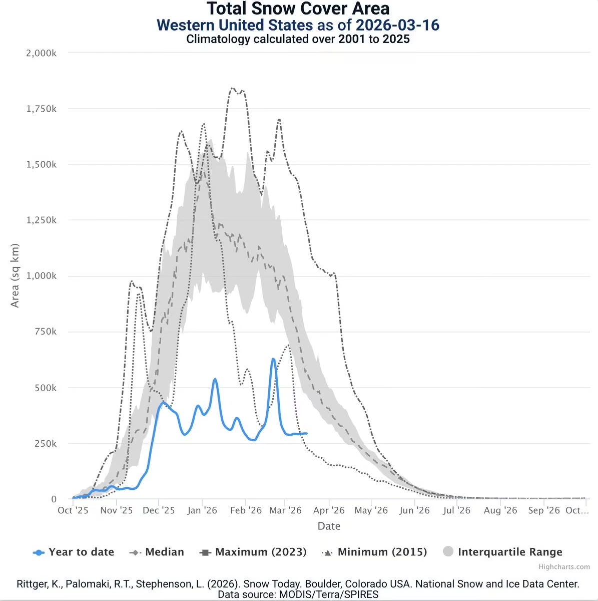
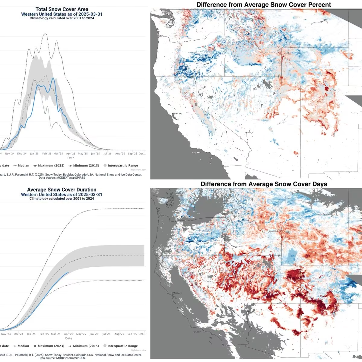
By March 31, snow cover across the western US tied with 2015 for the lowest on record since 2001. With no recent snowfall, snow has dropped to the darkest of the season, driving melt rates higher especially where cloud cover is sparse or tree cover lacks. nsidc.org/snow-today/snow-viewer
-
National Snow and Ice Data Center
@NSIDC
No foolin' a satellite image! Check out how quickly the snowpack disappears in the Colorado Rockies after a heat wave strikes the West. Browse snow data at NSIDC from NASA and NOAA: nsidc.org/data/search Snowpack images: worldview.earthdata.nasa.gov?v=-114.05134540267747,35.014…
-
National Snow and Ice Data Center
@NSIDC
It's the final countdown! After some 40 years, Iceberg A23a, once the world’s largest iceberg, is in its final break up in the Southern Ocean near South Georgia Island. NASA satellite imagery shows it spinning and fracturing from March 15 to March 28.
-
National Snow and Ice Data Center
@NSIDC
It's the final countdown! After some 40 years, Iceberg A23a, once the world’s largest iceberg, is in its final break up in the Southern Ocean near South Georgia Island. NASA satellite imagery shows it spinning and fracturing from March 15 to March 28.
-
National Snow and Ice Data Center
@NSIDC
📣 Join the NASA Applied Remote Sensing Training (ARSET) Program for a training on Monitoring Groundwater Changes for Water Resources Management. The first session of this three-part, no-cost, online training starts on April 23rd. Register today at: www.earthdata.nasa.gov/learn/trainings/monitoring-groundw…
-
National Snow and Ice Data Center
@NSIDC
Check out global views of data from the Ice, Cloud and Elevation Satellite-2 (ICESat-2) using NASA's Scientific Visualization Studio. ICESat-2 data are available at the NASA NSIDC Distributed Active Archive Center (DAAC). svs.gsfc.nasa.gov/5616/
-
National Snow and Ice Data Center
@NSIDC
Listen to NSIDC lead scientist Twila Moon speak about the World Meteorological Organization's annual climate report, which confirms that this past decade was the hottest on record and emphasizes that the Earth’s energy balance is badly out of whack. theworld.org/segments/2026/03/24/new-climate-report-docum…
-
National Snow and Ice Data Center
@NSIDC
NSIDC scientist Walt Meier speaks with the New York Times about this year's record low maximum sea ice extent in the Arctic and what it could mean. www.nytimes.com/2026/03/26/climate/arctic-sea-ice-ties-re…
-
National Snow and Ice Data Center
@NSIDC
Don't be part of the FOMO club. Subscribe to the NSIDC newsletter where you can read up on recent stories and data updates from NSIDC and its three programs: NASA NSIDC DAAC, NOAA@NSIDC, and ELOKA. nsidc.us12.list-manage.com/subscribe?u=3eed3adeb8ad095062…
-
National Snow and Ice Data Center
@NSIDC
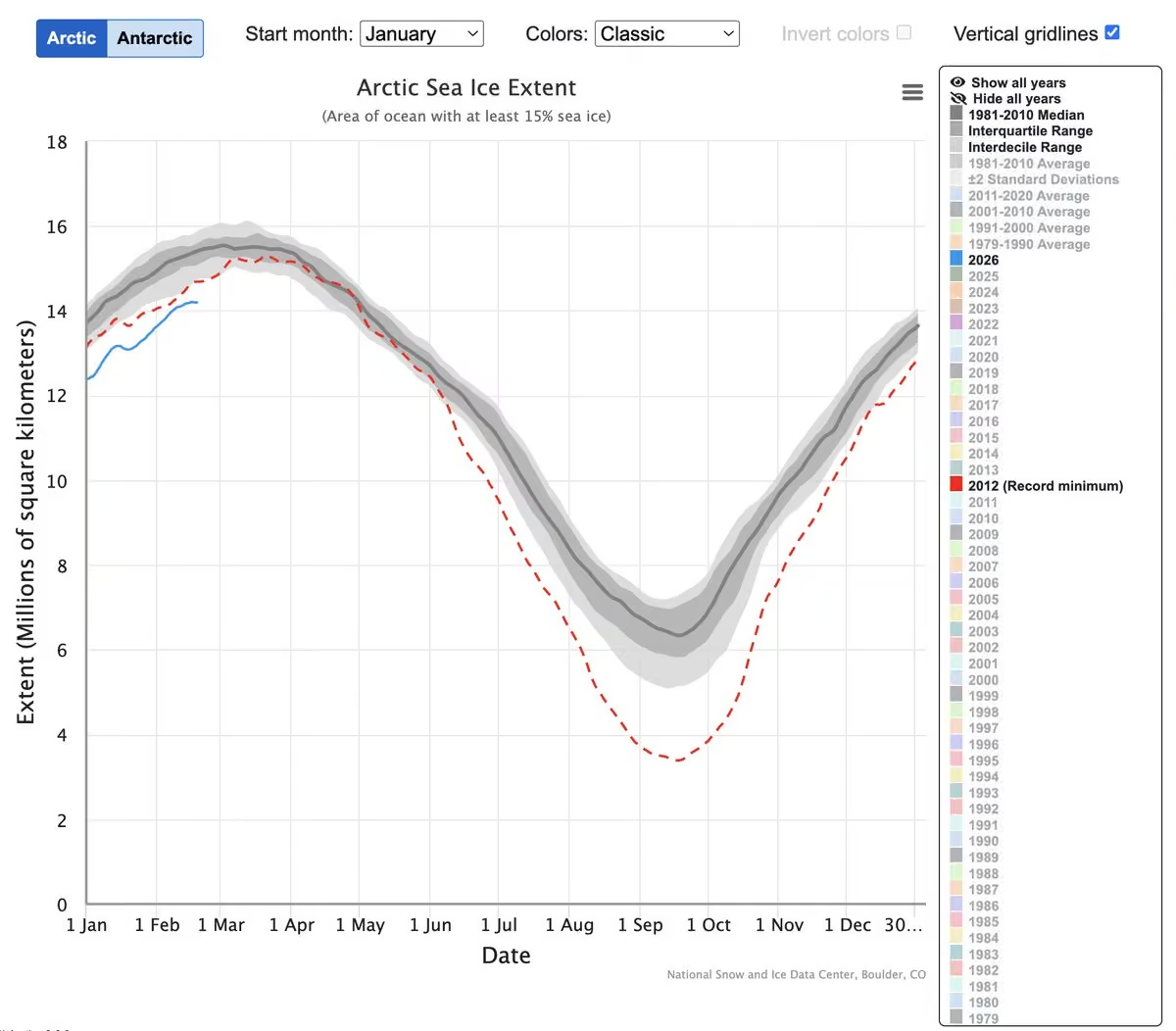
Arctic sea ice has likely reached its maximum extent, at 14.29 million square kilometers (5.52 million square miles) on March 15, edging just below last year’s record and statistically tying for the lowest maximum in the 48-year satellite record. nsidc.org/news-analyses/news-stories/arctic-sea-ice-recor…
-
National Snow and Ice Data Center
@NSIDC
Iceberg Alley is a stretch of water west of Greenland, where hundreds of icebergs drift annually. The NOAA@NSIDC program holds yearly summaries and reports of iceberg sightings beginning in 2024. The iceberg season runs from Oct 1 to Sept 30 the next year. nsidc.org/data/g10041/versions/1
-
National Snow and Ice Data Center
@NSIDC
Since January 14, 2026, total snow cover in Colorado has been at a record low in the 26-year-satellite record. Stay current on snow conditions with NSIDC's Snow Today. nsidc.org/snow-today/snow-viewer
-
National Snow and Ice Data Center
@NSIDC
The NASA NSIDC Distributed Active Archive Center has updated the Defense Meteorological Satellite Program (DMSP) Special Sensor Microwave Imager/Sounder (SSM/I-SSMIS) Daily Polar Gridded Brightness Temperatures, Version 6 data set through January 5, 2026. nsidc.org/data/user-resources/data-announcements/new-data…
-
National Snow and Ice Data Center
@NSIDC
NOAA@NSIDC’s Sea Ice Index offers easy visualization of daily and monthly extents, concentrations, anomalies, and trends. All you need is your web browser. nsidc.org/data/seaice_index
-
National Snow and Ice Data Center
@NSIDC
Sea ice ridging occurs when wind, ocean currents, and other forces push sea ice into piles that rise and form mounds above the level surface. Visit the NSIDC Cryosphere Glossary to discover more unique terms describing our frozen world. nsidc.org/learn/cryosphere-glossary
-
National Snow and Ice Data Center
@NSIDC
NASA’s Earthdata Cloud supports efficiency and collaboration, enabling new methods of data analysis and distribution while preserving most existing analysis and distribution methods for NASA NSIDC Distributed Active Archive Center (DAAC) data. nsidc.org/data/earthdata-cloud
-
National Snow and Ice Data Center
@NSIDC
An extreme heatwave with highs well above 90°F is brewing across the US West. Combined with this year’s record low snowpack, forecasters worry about water supply amidst an extended fire season. To view snow conditions in your area, see NSIDC’s Snow Today: nsidc.org/snow-today/snow-viewer
-
National Snow and Ice Data Center
@NSIDC
MODIS sensors have operated successfully since the Terra and Aqua satellites launched, so this continuous, consistent data record now spans a quarter of a century. Find MODIS snow and ice products at the NASA NSIDC Distributed Active Archive Center (DAAC). nsidc.org/data/modis
-
National Snow and Ice Data Center
@NSIDC
The NSIDC DAAC Advanced Microwave Scanning Radiometer Unified (AMSR Unified) collection covers data from 2002 for brightness temp, sea ice concentration/motion, precipitation, snow depth, snow water equivalent, soil moisture, and vegetation water content. nsidc.org/data/amsru
-
National Snow and Ice Data Center
@NSIDC
Watch a short video about one of NSIDC's programs: The Exchange for Local Observations and Knowledge of the Arctic (ELOKA). Learn about how ELOKA works with Arctic partners to preserve Indigenous Knowledge while facing drastic changes in the region. www.youtube.com/watch?v=xB676KoRLPw&t=4s
-
National Snow and Ice Data Center
@NSIDC
The NASA NSIDC Distributed Active Archive Center has released two new Soil Moisture Active Passive (SMAP) data sets derived from the Tropical Rainfall Measuring Mission and the Earth Remote Sensing satellite series. nsidc.org/data/user-resources/data-announcements/new-data…
-
National Snow and Ice Data Center
@NSIDC
Did you know NSIDC hosts three programs: NOAA@NSIDC, the NASA NSIDC Distributed Active Archive Center (DAAC), and the Exchange for Local Observations and Knowledge of the Arctic (ELOKA)? Stay current by signing up for our newsletter: nsidc.us12.list-manage.com/subscribe?u=3eed3adeb8ad095062…
-
National Snow and Ice Data Center
@NSIDC
What color is snow? Check out the answer to this question and other popular snow questions on NSIDC's Learn About the Cryosphere pages. nsidc.org/learn/parts-cryosphere/snow/quick-facts-about-snow
-
National Snow and Ice Data Center
@NSIDC
Antarctic sea ice has likely reached its minimum extent for the year, at 2.58 million square kilometers (996,000 square miles) on February 26, 2026, ranking sixteenth lowest in the 48-year satellite record. nsidc.org/news-analyses/news-stories/antarctic-sea-ice-ex…
-
National Snow and Ice Data Center
@NSIDC
The Cooperative Institute for Earth System Research and Data Science (CIESRDS), a partner of CU Boulder and NOAA, helps advance Earth system research and data science in areas critical to public safety, environmental resilience, and scientific innovation. www.youtube.com/watch?v=zqNU6mMT4T4
-
National Snow and Ice Data Center
@NSIDC
Season 8 of Energy Switch will air on the PBS app and on pbs.org (www.pbs.org/show/energy-switch/) on April 1! Watch NSIDC's senior researcher Twila Moon discuss the effects of a rapidly changing Arctic during episode 6. Check with your local station for broadcast dates.
-
National Snow and Ice Data Center
@NSIDC
Get to know a little about Mark Serreze, director of NSIDC, with this short Q&A from NSIDC's parent organization, CIRES: cires.colorado.edu/news/humans-cires-mark-serreze
-
National Snow and Ice Data Center
@NSIDC
Snow-covered area across the western United States was 38 percent of average for February, ranking last in the 26-year satellite record. The is the second month in a row to reach a record low. Read more from NSIDC's Snow Today: login.mailchimp.com?referrer=%2Fcampaigns%2Fwizard%2Fneap…
-
National Snow and Ice Data Center
@NSIDC
Can you drink melted sea ice? Read the answer to this sea ice question and others on NSIDC's Learn pages. nsidc.org/learn/parts-cryosphere/sea-ice/quick-facts-abou…
-
National Snow and Ice Data Center
@NSIDC
Use the NOAA@NSIDC MASIE-NH Daily Image Viewer to see where Arctic sea ice is now and how that data compares to the last four years. nsidc.org/data/masie
-
National Snow and Ice Data Center
@NSIDC
Researchers from the US and the UK have discovered a way to accurately predict Arctic sea ice patterns in real time using NSIDC sea ice data from 1978 to present. Get Sea Ice Index data: nsidc.org/data/seaice_index Article: www.thecooldown.com/outdoors/arctic-sea-ice-prediction-st…
-
National Snow and Ice Data Center
@NSIDC
The sheer volume of data coming from NASA satellites call for new approaches to managing vast archives of data. The NASA NSIDC Distributed Active Archive Center (DAAC) is adaption through Openscapes. nsidc.org/news-analyses/news-stories/cooking-collaborativ…
-
National Snow and Ice Data Center
@NSIDC
Released in January 2026, the ATLAS/ICESat-2 ATL02 Linear Impulse Response data set is now available from the NASA NSIDC DAAC. This new data set supports modeling surface and sub-surface scattering, and correcting for instrument effects. nsidc.org/data/ATL02_ANC_LIR/versions/1
-
National Snow and Ice Data Center
@NSIDC
The daily Sea Ice Index from NOAA@NSIDC provides a quick look at Arctic-wide changes in sea ice. It is a source for consistently processed ice extent and concentration images and data values since 1979. Toggle to see Antarctic sea ice. nsidc.org/data/seaice_index
-
National Snow and Ice Data Center
@NSIDC
The NOAA@NSIDC program has over 100 free data sets about Earth's frozen regions that include current and historical records on sea ice conditions, snow extent, glacier photographs, atlases, and declassified Cold War submarine observations of the Arctic. nsidc.org/data/data-programs/noaa-nsidc/about-noaansidc
-
National Snow and Ice Data Center
@NSIDC
You don't need an expensive plugin to explore satellite-measured elevation heights across the globe. You only need your web browser. nsidc.org/openaltimetry
-
National Snow and Ice Data Center
@NSIDC
The Canadian Ice Service produces Arctic regional sea ice charts on concentration, stage of development, and form by using in situ, satellite, and aerial reconnaissance data. Coverage: Jan 2006 to present. Get the data via FTP from NOAA@NSIDC. nsidc.org/data/g02171/versions/1
-
National Snow and Ice Data Center
@NSIDC
Two new data sets, the SnowEx23 Apr23 Snow Surface Reflectance and Albedo and SnowEx23 Oct22 IOP Snow Pits and Substrate Conditions at Freeze Up, are now available from the NASA NSIDC Distributed Active Archive Center (DAAC). nsidc.org/data/user-resources/data-announcements/new-data…
-
National Snow and Ice Data Center
@NSIDC
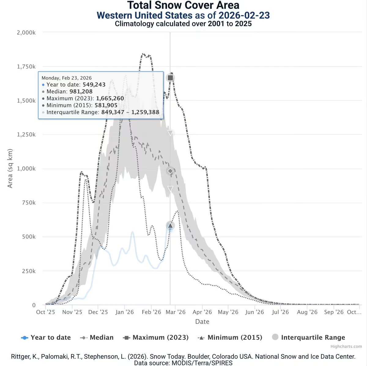
While a blizzard has struck the Northeast, the US West is still in a snow drought. Even with a week's reprieve of snowstorms in some areas, as of Feb 23, snow cover area has yet again dipped below the 2015 minimum record. Check out Snow Today for more: nsidc.org/snow-today/snow-viewer
-
National Snow and Ice Data Center
@NSIDC
The Western Snow Conference and Eastern Snow Conference will be held jointly in 2026 on the Auraria Campus, in the heart of downtown Denver, CO, May 12 to 15, 2026. For more information: westernsnowconference.org/annual-meetings/2026-annual-mee….
-
National Snow and Ice Data Center
@NSIDC
See the bedrock below the Antarctic Ice Sheet thanks to ice-penetrating radar surveys flown from 1967 to 2020. MEaSUREs BedMachine researchers stitched together all the data, now available from the NASA NSIDC Distributed Active Archive Center (DAAC). nsidc.org/data/NSIDC-0756/versions/4
-
National Snow and Ice Data Center
@NSIDC
Since the early 1970s, the satellite record shows an overall decline in Northern Hemisphere snow cover, with the largest losses in spring and summer. The trend is significant, but does not capture how changes in snow cover vary by location and season. nsidc.org/learn/ask-scientist/snow-cover-changing
-
National Snow and Ice Data Center
@NSIDC
Want to see our data in three dimensions? We have a Google Earth map for that. nsidc.org/data/google_earth
-
National Snow and Ice Data Center
@NSIDC
Arapaho Glacier is Colorado's largest glacier. In 123 years, the glacier has lost more than 50% of its area. NSIDC's Glacier Photo Collection contains over 25,000 digital photographs of global glaciers, some dating back to the mid-19th century. nsidc.org/data/g00472/versions/1
-
National Snow and Ice Data Center
@NSIDC
March is the time of year when Arctic sea ice reaches its maximum extent and when Antarctic sea ice approaches its minimum. Use NSIDC's Charctic tool to see where sea ice stands now and how it compares to other years. nsidc.org/sea-ice-today/sea-ice-tools/charctic-interactiv…
-
National Snow and Ice Data Center
@NSIDC
Version 2 of data from the Visible Infrared Imaging Radiometer Suite (VIIRS) are now available from the NASA NSIDC DAAC. Updated data sets include snow cover, sea ice cover, and sea ice temperature observations. nsidc.org/data/user-resources/data-announcements/new-data…
-
National Snow and Ice Data Center
@NSIDC
More than 200 scientists have signed a statement in solidarity with Greenland to show support for the country's autonomy, including at least 20 from @CUBoulder. CU Boulder Today spoke with lead NSIDC scientist Twila Moon about the letter. www.colorado.edu/today/2026/02/04/us-greenland-science-pa…
-
National Snow and Ice Data Center
@NSIDC
Soil moisture data from the @NASA Aquarius mission help scientists monitor freezing and thawing events, predict droughts, and even refine weather forecasts. Download the data from the NASA NSIDC Distributed Active Archive Center (DAAC). nsidc.org/data/amsr
-
National Snow and Ice Data Center
@NSIDC
When it comes to glaciers, one size does not fit all. Nor does one name. How many types of glaciers do you know? nsidc.org/learn/parts-cryosphere/glaciers/science-glaciers
-
National Snow and Ice Data Center
@NSIDC
A Haiku from the @NASA NSIDC Distributed Active Archive Center (DAAC):
Meant to last three years,
It lasted just ten fab months.
The data live on.
nsidc.org/data/amsr -
National Snow and Ice Data Center
@NSIDC
Whether you're worried about droughts or floods, SMAP data from the @NASA NSIDC Distributed Active Archive Center (DAAC) can help you prepare. nsidc.org/data/smap
-
National Snow and Ice Data Center
@NSIDC
The NASA NSIDC Distributed Active Archive Center (DAAC) offers a Python library that lets you visualize more than 25 years of lidar data about fast-changing icy regions. nsidc.org/news-analyses/news-stories/there-and-back-again…
-
National Snow and Ice Data Center
@NSIDC
Scientists use climate models to predict how the climate might change in the future, but what exactly are climate models? How do they work and how have they changed over time? nsidc.org/learn/ask-scientist/what-are-climate-models
-
National Snow and Ice Data Center
@NSIDC
Ever wonder why it's so quiet after a snowstorm? Or what happens to the sound as the snow surface changes? Learn more from NSIDC's science of snow. nsidc.org/learn/parts-cryosphere/snow/science-snow
-
National Snow and Ice Data Center
@NSIDC
More than 8,500 daily heat records have been tied or broken in the West this winter. "I have not seen a winter like this," said NSIDC director Mark Serreze, who has been in Colorado almost 40 years. "This pattern that we're in is so darned persistent." www.kbzk.com/weather/record-snow-drought-in-western-us-ra…
-
National Snow and Ice Data Center
@NSIDC
Arapaho Glacier, located in the Front Range of Colorado's Rocky Mountains, has lost 52% of its area in the 20th century. Check out data from the NASA NSIDC DAAC Global Land Ice Measurements from Space (GLIMS) initiative inventories the world’s glaciers. nsidc.org/data/glims/data
-
National Snow and Ice Data Center
@NSIDC
Ted Scambos, a University of Colorado senior researcher with @CIRESnews, estimates that Boulder's Arapaho Glacier has lost half its volume in twenty years. “It’s sad to see it go, and it’s right here before our eyes,” Scambos said. www.coloradohometownweekly.com/2026/02/08/arapaho-glacier…
-
National Snow and Ice Data Center
@NSIDC
A snow drought has gripped the US West. January set a record for lowest snow cover in 26 years of satellite monitoring. Although snow water equivalent (SWE) increased at almost all monitoring stations, many still finished the month with below-average SWE. nsidc.org/snow-today/monthly-insights/snow-drought-west
-
National Snow and Ice Data Center
@NSIDC
Higher temperatures with average precipitation means more rain, less snow for the West. This image, from MODIS on NASA’s Terra satellite, shows meager western snow cover on January 15. Check out NSIDC's Snow Today site: nsidc.org/snow-today Article: science.nasa.gov/earth/earth-observatory/the-west-faces-s…
-
National Snow and Ice Data Center
@NSIDC
On July 31, 2025, the NASA NSIDC DAAC released ATL03 global geolocated photon data in cloud-optimized HDF5, making ICESat-2 NASA’s first mission to publish in this format, thus improving the data speed and scalability for cloud-based science and research. nsidc.org/news-analyses/news-stories/cloud-optimized-hdf5…
-
National Snow and Ice Data Center
@NSIDC
SnowEx data are archived at the NASA NSIDC Distributed Active Archive Center (DAAC). The SnowEx campaign and new @NASA NISAR satellite mission are improving high-resolution snowpack monitoring to improve decision making in critical river basins around the world.
-
National Snow and Ice Data Center
@NSIDC
Happy Holidays from NSIDC!
-
National Snow and Ice Data Center
@NSIDC
Happy Holidays from NSIDC!
-
National Snow and Ice Data Center
@NSIDC
Need a Christmas gift idea for someone interested in the Arctic? This book "What Once Was Snow: Stories of Change, Adaptation, and Resilience in the Arctic" is an exploration of what it means to live in a world where snow is becoming more unpredictable. nsidc.org/rain-on-snow/book
-
National Snow and Ice Data Center
@NSIDC
The 2025 Arctic Report Card takeaways: Arctic air temperatures were the highest on record in 125 years. Maximum Arctic sea ice extent in March 2025 hit a record low. In the Bering Sea, warming waters, less sea ice, more phytoplankton, more food insecurity. arctic.noaa.gov/report-card/
-
National Snow and Ice Data Center
@NSIDC
Arctic sea ice extent moved into record low territory on Nov. 30, after tracking second lowest for most of November. This is another marker in a decades-long decline in Arctic sea ice as the region continues to warm rapidly. nsidc.org/sea-ice-today
-
National Snow and Ice Data Center
@NSIDC
Our Glacier Photograph Collection is an online, searchable collection of photos of glaciers, mostly taken in the Rocky Mountains, the Pacific Northwest, Alaska, and Greenland. As of August 2021, more than 25,000 glacier photographs are in the database. nsidc.org/data/glacier_photo/index.html
-
National Snow and Ice Data Center
@NSIDC
The VIIRS instrument, a scanning radiometer, acquires visible and infrared imagery and radiometric measurements of Earth’s landmasses and oceans. Get VIIRS data at the NSIDC DAAC: nsidc.org/data/viirs
-
National Snow and Ice Data Center
@NSIDC
The Beaufort Gyre is an ocean and ice circulation pattern in the Beaufort Sea, north of Alaska. This gyre moves in a clockwise direction, fed by an average high-pressure system that fosters anti-cyclonic winds.
Find more terms in our Cryosphere Glossary: nsidc.org/learn/cryosphere-glossary -
National Snow and Ice Data Center
@NSIDC
SINTER: Snow International is an international group of scientists and engineers sharing a passion for snow science. Their goal is to create a community for students and professionals alike to find others and share research and ideas.
Learn more: nsidc.org/sinter/about-sinter -
National Snow and Ice Data Center
@NSIDC
The NSIDC DAAC Making Earth System Data Records for Use in Research Environments data collection includes data products derived from satellite data and created by researchers for researchers. These data products encompass snow, sea ice, glaciers, & more. nsidc.org/data/measures
-
National Snow and Ice Data Center
@NSIDC
The Sea Ice Prediction Network is a collaborative network, made up of scientists and stakeholders, that aims to improve upon and communicate about sea ice forecasting and prediction. NSIDC is involved in several ways.
Learn more: nsidc.org/our-research/featured-projects/sea-ice-predicti… -
National Snow and Ice Data Center
@NSIDC
The monthly Sea Ice Index provides a quick look at Antarctic-wide changes in sea ice. It is a source for consistently processed ice extent and concentration images and data values since 1979.
Check it out: nsidc.org/data/seaice_index -
National Snow and Ice Data Center
@NSIDC
Rain on Snow events occur when rain falls onto an existing snowpack and freezes, forming an ice crust that can have severe consequences to wildlife, infrastructure, and communities. Learn more: nsidc.org/rain-on-snow/ros-impacts
Image credit: Julia Gustafson, NSIDC -
National Snow and Ice Data Center
@NSIDC
QGreenland is a free mapping tool to support interdisciplinary Greenland-focused research, teaching, decision making & collaboration. It combines key datasets into a unified, all-in-one GIS analysis and visualization environment for offline and online use.
qgreenland.org -
National Snow and Ice Data Center
@NSIDC
Starting Oct 15, 2025, several NSIDC Sea Ice Today & Ice Sheets Today tools will be reduced due to lapsed funding. Some updates will stop, but data will remain available.
📢 Share how you use these tools: nsidc@nsidc.org
More info: nsidc.org/data/user-resources/data-announcements -
National Snow and Ice Data Center
@NSIDC
Scientists can use ICESat-2 data to monitor changes in sea ice thickness over time, to detect icebergs and forecast where they will travel, and to better predict how Earth’s melting glaciers will impact global sea rise in the future. Get data: nsidc.org/data/icesat-2
-
National Snow and Ice Data Center
@NSIDC
High Mountain Asia has one of the highest concentrations of snow and glacier ice outside of the polar regions. The NSIDC DAAC High Mountain Asia data collection includes data related to snow and ice in this region.
Get data: nsidc.org/data/highmountainasia. Image credit: Audrey Payne -
National Snow and Ice Data Center
@NSIDC
The NSIDC DAAC MODIS data collection includes a suite of snow cover & sea ice data products from NASA’s Moderate Resolution Imaging Spectroradiometer instruments on the Terra & Aqua satellites, providing a continuous observation record dating back to 2000. nsidc.org/data/modis
-
National Snow and Ice Data Center
@NSIDC
Hoarfrost is a deposit of interlocking ice crystals formed by direct sublimation on objects, usually those of small diameter freely exposed to the air, such as tree branches, plant stems, etc. Learn more in our Cryosphere Glossary: nsidc.org/learn/cryosphere-glossary
Image credit: NPS -
National Snow and Ice Data Center
@NSIDC
The AMSR-E data collection at the NSIDC DAAC comes from the AMSR-E sensor that flew onboard NASA’s Aqua satellite, observing interactions between snow & ice, and Earth's atmosphere & ocean. Get data: nsidc.org/data/amsre
-
National Snow and Ice Data Center
@NSIDC
Earthdata Cloud is a NASA Earth Science Data Systems program that enables new methods of data analysis & distribution, while preserving most existing analysis & distribution methods. Read our FAQs about the NASA Earthdata Cloud: nsidc.org/data/user-resources/help-center/faqs-about-nsid…
-
National Snow and Ice Data Center
@NSIDC
The NSIDC DAAC Aquarius collection includes global gridded soil moisture data and additional polar gridded products. These data products are derived from observations by the Aquarius microwave radiometers and scatterometer. Get data at the NSIDC DAAC: nsidc.org/data/aquarius
-
National Snow and Ice Data Center
@NSIDC
Did you know that you can view glacier change over time using Google Earth? Check out our "Glaciers and Climate Change" files for glacier photograph pairs showing how some glaciers have changed over time: nsidc.org/data/google_earth
-
National Snow and Ice Data Center
@NSIDC
The NSIDC DAAC manages data related to the NASA SnowEx campaigns. Data products are diverse, ranging from snow depth measurements to radar reflectivity. Find data here: nsidc.org/data/snowex
-
National Snow and Ice Data Center
@NSIDC
Wondering what's happening with Arctic and Antarctic sea ice extent and how it compares to past months, years, and the average? Check out our Charctic tool: nsidc.org/sea-ice-today/sea-ice-tools/charctic-interactiv…
-
National Snow and Ice Data Center
@NSIDC
NASA’s Terrestrial Hydrology Program initiated the SnowEx campaigns to fill knowledge gaps related to remote sensing of snow and has endeavored to more accurately measure snow characteristics in a variety of terrains & vegetation canopies & more. Get data: nsidc.org/data/snowex
-
National Snow and Ice Data Center
@NSIDC
The Evenki Atlas focuses on sharing the knowledge, wisdom and culture of one of the Indigenous Nations of Siberia, Russian Federation: the Evenki. It is estimated that approximately 36,000 Evenki live today and 7,000 speak the language. eloka.nsidc.org/products/evenki-atlas
-
National Snow and Ice Data Center
@NSIDC
Have you signed up for our monthly newsletter yet? Do so here for data updates, new research, and news about the frozen parts of the planet: nsidc.us12.list-manage.com/subscribe?u=3eed3adeb8ad095062…. Photo credit: Matthew Druckenmiller, NSIDC
-
National Snow and Ice Data Center
@NSIDC
From 2002 to 2011, AMSR-E flew onboard NASA's Aqua satellite, collecting passive microwave measurements of land and ocean parameters related to global water and energy cycles.
Get data at the NSIDC DAAC: nsidc.org/data/amsre -
National Snow and Ice Data Center
@NSIDC
Our Browse Image Subset Tool can display Sea Ice Index trends in ice extent as line plots, and trends in ice concentration as map images. This allows one to see the difference between northern and southern hemisphere sea ice extent variability and trends. nsidc.org/data/bist-how-use
-
National Snow and Ice Data Center
@NSIDC
Our NOAA@NSIDC program preserves data over the long term to support current & future research. Data come from varied sources: satellites, in situ observations, weather services, historical records, and rescued data.
Learn more and get data: nsidc.org/data/data-programs/noaa-nsidc -
National Snow and Ice Data Center
@NSIDC
What's happening with Arctic and Antarctic sea ice extent now, and how does it compare to past months and years? Use our Charctic tool to find out: nsidc.org/sea-ice-today/sea-ice-tools/charctic-interactiv…
-
National Snow and Ice Data Center
@NSIDC
Thwaites Glacier is 1 of the fastest-retreating glaciers in Antarctica. This colossal glacier covers an area roughly the size of Florida and it is rapidly losing ice to the ocean in response to climate change and changes in ocean circulation.
Learn more: nsidc.org/our-research/featured-projects/international-th… -
National Snow and Ice Data Center
@NSIDC
The NSIDC DAAC Airborne Snow Observatory data collection includes snow depth, snow water equivalent, and lidar point cloud terrain models derived from airborne remote sensing campaigns conducted over the western US. Get data: nsidc.org/data/aso
-
National Snow and Ice Data Center
@NSIDC
NASA’s OpenAltimetry is a powerful map-based data visualization and discovery tool for exploring surface elevation profiles from ICESat and ICESat-2 satellite mission altimetry data.
Learn more: nsidc.org/openaltimetry/about -
National Snow and Ice Data Center
@NSIDC
The Ice, Cloud and land Elevation Satellite-2 (ICESat-2) is the 3rd in a series of NASA missions designed to provide continuous polar observations over time. Get ICESat-2 data at the NSIDC DAAC: nsidc.org/data/icesat-2
-
National Snow and Ice Data Center
@NSIDC
The Terra and Aqua MODIS instruments image the same area on Earth approximately 3 hours apart. The entire Earth's surface is imaged every 1-2 days, and the sensors work in tandem to optimize cloud-free surface viewing.
Get MODIS data at the NSIDC DAAC: nsidc.org/data/modis -
National Snow and Ice Data Center
@NSIDC
On September 17, Antarctic sea ice likely reached its annual maximum extent of 17.81 million square kilometers (6.88 million square miles). The 2025 maximum is the third lowest in the 47-year satellite record above 2023 and 2024. nsidc.org/sea-ice-today/analyses/antarctic-sea-ice-maximu…
-
National Snow and Ice Data Center
@NSIDC
Permafrost is ground that is frozen for at least 2 years. In many cases, permafrost has existed for many thousands of years and can be thousands of feet deep. Most of Earth’s permafrost lies in the Arctic but some is in the Antarctic & in high mountains. nsidc.org/learn/parts-cryosphere/frozen-ground-permafrost
-
National Snow and Ice Data Center
@NSIDC
SINTER: Snow International is a community specifically focused on seasonal snow and remote sensing. Their mission is to provide the techniques and methods needed to answer the world's pressing snow problems.
Learn more: nsidc.org/sinter/about-sinter -
National Snow and Ice Data Center
@NSIDC
Because sea ice does not stay in the Antarctic as long as it does in the Arctic, it does not have the opportunity to grow as thick. Antarctic sea ice is typically 1 to 2 meters thick, while Arctic sea ice is typically 2 to 3 meters thick. nsidc.org/learn/parts-cryosphere/sea-ice
-
National Snow and Ice Data Center
@NSIDC
The NSIDC DAAC Nimbus data collection includes satellite images from the 1960s, 1970s & 1980s. This collection stems from a data rescue project, which saw NSIDC digitizing black & white film images and infrared radiometer data from Nimbus satellites.
nsidc.org/data/nimbus -
National Snow and Ice Data Center
@NSIDC
Sea ice is frozen seawater that floats on the ocean surface, waxing and waning with the polar seasons. In the Arctic winter, sea ice stretches its tentacles into seas and coastlines far from the poles. Antarctic sea ice fringes a massive land mass. More: nsidc.org/learn/parts-cryosphere/sea-ice
-
National Snow and Ice Data Center
@NSIDC
NASA initiated SnowEx to fill knowledge gaps related to remote sensing of snow, aiming to more accurately measure snow characteristics in a variety of terrains and vegetation canopies, check airborne measurements against ground-truth fieldwork, and more. nsidc.org/data/snowex
-
National Snow and Ice Data Center
@NSIDC
Sea ice differs between the Arctic and Antarctic, primarily because of their different geographies. Check out these maps of the Arctic Ocean and Antarctica to better understand the differences: nsidc.org/sea-ice-today/maps
-
National Snow and Ice Data Center
@NSIDC
“Open science is the idea that scientific knowledge of all kinds should be openly shared as early as is practical in the discovery process.” –Michael Nielson
NSIDC champions open science for several reasons. Learn more here: nsidc.org/our-research -
National Snow and Ice Data Center
@NSIDC
The Sea Ice Index provides a quick look at Arctic- and Antarctic-wide changes in sea ice. The images and data are produced in a consistent way that makes the Index time-series appropriate for use when looking at long-term trends in sea ice cover. nsidc.org/data/seaice_index
-
National Snow and Ice Data Center
@NSIDC
Our Sea Ice Analysis Tool allows users to analyze monthly-averaged or daily sea ice extent & concentration via interactive maps. Also, users can plot monthly ice extent anomalies, map sea ice concentration anomalies, and more. nsidc.org/sea-ice-today/sea-ice-tools/sea-ice-analysis-tool
-
National Snow and Ice Data Center
@NSIDC
A vast collection of glacier time lapse images are archived at NSIDC as the Extreme Ice Survey Glacier Image Archive, 2007-2022. The collection contains 1.5 million images documenting glacial change over the 15 years of James Balog's Extreme Ice Survey. nsidc.org/data/nsidc-0783/versions/1
-
National Snow and Ice Data Center
@NSIDC
Our sea ice extent spatial comparison tool allows users to spatially compare sea ice extent for any two days or months between 1979 and present. Check it out: nsidc.org/sea-ice-today/sea-ice-tools/sea-ice-spatial-com…
-
National Snow and Ice Data Center
@NSIDC
The earthaccess Python library provides an easy way to search, download, or stream NASA Earth science data using a few lines of code. It was created by Luis López, an NSIDC software developer. Learn more about earthaccess: www.earthdata.nasa.gov/news/blog/earthaccess-earth-scienc…
-
National Snow and Ice Data Center
@NSIDC
Depending on who is using the data and to what end, sea ice data can be misread and even used in disinformation campaigns about Earth’s climate. In this "Ask A Scientist," NSIDC discusses 5 common misuses of sea ice data. nsidc.org/learn/ask-scientist/can-sea-ice-data-ever-be-mi…
-
National Snow and Ice Data Center
@NSIDC
The NASA Land, Vegetation and Ice Sensor instrument uses lidar scanning laser altimeters to collect topography and vegetation coverage data over land, ocean, and ice surfaces, along with downward-looking, high-resolution camera imagery.
Get data: nsidc.org/data/lvis -
National Snow and Ice Data Center
@NSIDC
How does Arctic sea ice loss affect coastlines? As Arctic sea ice melts to reveal the open ocean underneath, fragile coastlines become vulnerable to bigger waves from storms, leading to accelerated erosion that impacts people and wildlife. Learn more: nsidc.org/learn/ask-scientist/how-does-arctic-sea-ice-los…
-
National Snow and Ice Data Center
@NSIDC
The Global Land Ice Measurements from Space Glacier Database includes measurements of glacier geometry, glacier area, snowlines, supraglacial lakes and rock debris, & more from approximately 70% of the world's 200,000 glaciers. Check it out:
-
National Snow and Ice Data Center
@NSIDC
What do scientists mean by ice-free Arctic? “Ice-free” is based on a threshold for sea ice extent: the area of ocean with at least 15% sea ice concentration. The Arctic Ocean is effectively ice free when its sea ice extent falls below 1 million sq km. nsidc.org/learn/ask-scientist/what-do-scientists-mean-ice…
-
National Snow and Ice Data Center
@NSIDC
The Arctic Rain on Snow Study at NSIDC seeks to find out if rain on snow events have already become more frequent and intense in the Arctic, while compiling a comprehensive understanding of these events and their impacts on wildlife, ecology & communities. nsidc.org/rain-on-snow/about
-
National Snow and Ice Data Center
@NSIDC
On September 10, Arctic sea ice likely reached its annual minimum extent of 4.60 million square kilometers (1.78 million square miles). The 2025 minimum shares the tenth lowest spot in the nearly 47-year satellite record with 2008 and 2010. nsidc.org/sea-ice-today/analyses/2025-arctic-sea-ice-mini…
-
National Snow and Ice Data Center
@NSIDC
ICESat-2 is the 3rd in a series of NASA missions designed to provide continuous polar observations over time. Previous missions include the ICESat mission, which collected satellite observations from 2003-2010, followed by Operation IceBridge. Get data: nsidc.org/data/icesat-2
-
National Snow and Ice Data Center
@NSIDC
Images of Antarctic Ice Shelves is a data set created as part of an effort to closely monitor major ice streams and outlet glaciers along the Antarctic coast. Check it out: nsidc.org/data/nsidc-0102/versions/2
-
National Snow and Ice Data Center
@NSIDC
The MEaSUREs: Greenland Ice sheet Mapping Project (GrIMP) was organized to provide benchmark data sets for observing ice sheet stability and change on Greenland. GrIMP temporal coverage ranges from the year 1985 to present. Learn more and get data: nsidc.org/data/measures
-
National Snow and Ice Data Center
@NSIDC
The Evenki Atlas from our ELOKA program focuses on sharing the knowledge, wisdom, and culture of one of the Indigenous Nations of Siberia, Russian Federation, the Evenki, who live in Iyengra, Russia, and the surrounding taiga. eloka.nsidc.org/products/evenki-atlas
-
National Snow and Ice Data Center
@NSIDC
The GLIMS Glacier Database includes measurements of glacier geometry, glacier area, snowlines, supraglacial lakes and rock debris, and more. The collection includes data from approximately 70% of the world's 200,000 glaciers. Learn more: nsidc.org/data/glims
-
National Snow and Ice Data Center
@NSIDC
The NASA Earthdata Cloud Cookbook is a comprehensive resource that provides tutorials, guides, and examples for accessing and working with NASA data in the cloud. Check it out: nasa-openscapes.github.io/earthdata-cloud-cookbook/
-
National Snow and Ice Data Center
@NSIDC
The NSIDC DAAC manages data from the NASA SnowEx mission. Data are collected from a series of airborne & ground campaigns in the western US. Data products are diverse, ranging from snow depth measurements to radar reflectivity. Get data: nsidc.org/data/snowex
-
National Snow and Ice Data Center
@NSIDC
The NSIDC DAAC High Mountain Asia collection includes data related to snow and ice in a region that stretches across five mountain ranges, including the Himalaya and Hindu Kush. Water from these mountains support about 1.5 billion people. nsidc.org/data/highmountainasia
-
National Snow and Ice Data Center
@NSIDC
Sign up here for our monthly newsletter for data news, new research, and fun facts about the cryosphere! nsidc.us12.list-manage.com/subscribe?u=3eed3adeb8ad095062… Photo credit: Matthew Druckenmiller, NSIDC
-
National Snow and Ice Data Center
@NSIDC
NSIDC researchers Twila Moon and Julienne Stroeve joined dozens of polar scientists to sound the alarm against polar geoengineering. The authors warned against "severe environmental damage" and urged countries to focus on reaching net zero emissions. www.frontiersin.org/journals/science/articles/10.3389/fsc…
-
National Snow and Ice Data Center
@NSIDC
In August, sea ice rapidly melted and compacted north of Alaska in the Beaufort Sea. However, the overall pace of decline for the month was near average. Antarctic sea ice climbed in August but remained well below average, ranking third lowest extent. nsidc.org/sea-ice-today/analyses/taking-bite-out-beaufort
-
National Snow and Ice Data Center
@NSIDC
QGreenland is a free mapping tool to support interdisciplinary Greenland-focused research, teaching, decision making & collaboration. It combines key datasets into a unified, all-in-one GIS analysis & visualization environment for offline & online use. qgreenland.org
-
National Snow and Ice Data Center
@NSIDC
Our Browse Image Spreadsheet Tool allows you to look at an array of browse images and to manipulate the parameters controlling each axis of the array with a spreadsheet-like interface. Learn how to use it: nsidc.org/data/bist-how-use
-
National Snow and Ice Data Center
@NSIDC
NSIDC DAAC Aquarius soil moisture data products were produced by a NASA-funded team at the U.S. Department of Agriculture that developed a technique to derive soil moisture data from Aquarius observations. Get data: nsidc.org/data/aquarius
-
National Snow and Ice Data Center
@NSIDC
If you're looking for monthly Arctic or Antarctic sea ice extent and rankings, find them on the second spreadsheet on our sea ice data tools page: nsidc.org/sea-ice-today/sea-ice-tools
-
National Snow and Ice Data Center
@NSIDC
The NSIDC DAAC Advanced Microwave Scanning Radiometer Unified (AMSR Unified) collection includes passive microwave data products on snow, sea ice, soil moisture, vegetation water content, and brightness temperature.
Get data at the NSIDC DAAC: nsidc.org/data/amsru -
National Snow and Ice Data Center
@NSIDC
If you are looking for Arctic or Antarctic sea ice extent for specific dates, check out the first spreadsheet on our sea ice data tools page. Note that we use a 5-day average for daily extent, so look for the "5-day" tab on the spreadsheet: nsidc.org/sea-ice-today/sea-ice-tools
-
National Snow and Ice Data Center
@NSIDC
At NSIDC, we conduct research & provide open data to understand how the frozen parts of Earth affect the rest of the planet & impact society. Research studies & data are primarily focused on snow, ice, glaciers, frozen ground & climate interactions. nsidc.org/about/about-nsidc/what-we-do
-
National Snow and Ice Data Center
@NSIDC
Has Antarctic sea ice hit a breaking point? Several recent studies explore that idea using statistical analysis of sea ice extent data from the NSIDC DAAC and NOAA@NSIDC: nsidc.org/learn/ask-scientist/has-antarctic-sea-ice-hit-b…
-
National Snow and Ice Data Center
@NSIDC
The NSIDC Satellite Observations of Arctic Change transforms time series data from NASA satellites into interactive maps for users to visualize and study changes in the Arctic. They show sea ice extent and age, snow cover, frozen ground & more. nsidc.org/data/soac
-
National Snow and Ice Data Center
@NSIDC
NSIDC scientists and gamers explore an immersive new way to visualize climate data. Designed for PlayStation 5 (PS5) and enhanced for PlayStation Virtual Reality 2 (PS VR2), Climate Station puts users in the middle of Earth’s most critical story: our own. nsidc.org/news-analyses/news-stories/svalbard-your-living…
-
National Snow and Ice Data Center
@NSIDC
MODIS is the 1st NASA mission to provide daily global coverage at moderate resolution. MODIS sensors have operated successfully since the Terra and Aqua satellites launched, so the data collection provides a continuous observation record back to 2000. nsidc.org/data/modis
-
National Snow and Ice Data Center
@NSIDC
Did you know that the NASA NSIDC Distributed Active Archive Center (DAAC) archives and distributes soil moisture data sets that support American agriculture?Whatever the crop, this data provide a real-time snapshot of soil conditions to better plan. nsidc.org/news-analyses/news-stories/sensing-soil-moistur…
-
National Snow and Ice Data Center
@NSIDC
The monthly Sea Ice Index from NOAA@NSIDC provides a quick look at Arctic-wide changes in sea ice. It is a source for consistently processed ice extent and concentration images and data values since 1979. Check it out: nsidc.org/data/seaice_index
-
National Snow and Ice Data Center
@NSIDC
When combined with data from the ICESat/GLAS and Operation IceBridge data collections, ICESat-2 data enable researchers to investigate and better understand changes occurring to the cryosphere over time. Get data at the NSIDC DAAC: nsidc.org/data/icesat-2
-
National Snow and Ice Data Center
@NSIDC
A strong melt event occurred in southern Greenland in mid-August 2025, preceded by extensive rain in the same area. Snowfall then brightened the dark, bare ice on the western coast. Overall, Greenland’s 2025 melt season appears to be moderately intense. nsidc.org/ice-sheets-today/analyses/august-greenland-melt…
-
National Snow and Ice Data Center
@NSIDC
NSF's Navigating the New Arctic initiative uses convergence research to fill in scientific knowledge gaps in the Arctic to address climate-related challenges. NSIDC cohosts the NNA Community Office to support the goals of the initiative. nsidc.org/our-research/featured-projects/navigating-new-a…
-
National Snow and Ice Data Center
@NSIDC
The Arctic Rain on Snow Study consists of multiple studies and projects that, when tied together, create a holistic understanding of Arctic rain on snow events and their impacts. Learn about the study: nsidc.org/our-research/featured-projects/arctic-rain-snow…
-
National Snow and Ice Data Center
@NSIDC
The NOAA@NSIDC program offers over 100 diverse data sets, including decades-long records of snow extent, historic glacier photographs, atlases assembled through international collaborations, even declassified Cold War submarine observations of the Arctic. nsidc.org/data/data-programs/noaa-nsidc
-
National Snow and Ice Data Center
@NSIDC
NASA Worldview can be used to interactively browse and download full-resolution, global satellite imagery from over 1000 NASA data products including NSIDC DAAC data.
Learn more: -
National Snow and Ice Data Center
@NSIDC
With satellite observations of sea ice extent stretching back to November 1978, NSIDC scientists can draw from more than 40 years of data to determine when an extent is above or below average or when it reaches a record high or low. Learn more: nsidc.org/learn/ask-scientist/how-low-low
-
National Snow and Ice Data Center
@NSIDC
The NSIDC DAAC SnowEx collection includes data products from the NASA SnowEx mission. SnowEx data are collected from a series of airborne & ground campaigns in the western US and range from snow depth measurements to radar reflectivity.
Get data: nsidc.org/data/snowex -
National Snow and Ice Data Center
@NSIDC
Sea ice can be as thin as a few sheets of paper or as thick as a house, depending on how long it has existed. Measuring sea ice thickness is harder than measuring how much sea ice covers the ocean surface but multiple approaches have been used. Learn more: nsidc.org/learn/ask-scientist/how-thick-is-sea-ice
-
National Snow and Ice Data Center
@NSIDC
Rain on Snow events occur when rain falls onto an existing snowpack & freezes, forming an ice crust that can have severe consequences to wildlife, infrastructure & communities. Every rain on snow event has its own character—no 2 are alike. Learn more: nsidc.org/rain-on-snow/about
-
National Snow and Ice Data Center
@NSIDC
What is the difference between sea ice area and extent? Sea ice area is the total region covered by ice. Extent is the total region with at least 15% sea ice cover. NSIDC usually reports extent, which gives higher values than area. Learn more: nsidc.org/learn/ask-scientist/what-difference-between-sea…
-
National Snow and Ice Data Center
@NSIDC
The NSIDC DAAC MODIS data collection includes a suite of snow cover & sea ice data products from NASA’s MODIS instruments on the Terra & Aqua satellites. These data facilitate a better understanding of how the cryosphere has influenced our planet. nsidc.org/data/modis
-
National Snow and Ice Data Center
@NSIDC
Antarctic sea ice differs from Arctic sea ice. The Arctic is an ocean basin surrounded by land; Antarctica is a continent surrounded by ocean. Arctic sea ice has declined directly in relation to warming climate, Antarctic sea ice has shown no clear trend. nsidc.org/learn/ask-scientist/how-does-antarctic-sea-ice-…
-
National Snow and Ice Data Center
@NSIDC
The NSIDC DAAC Making Earth System Data Records for Use in Research Environments data collection includes data products derived from satellite data and created by researchers for researchers. These data products encompass snow, sea ice, glaciers and more. nsidc.org/data/measures
-
National Snow and Ice Data Center
@NSIDC
Scientists once thought Arctic sea ice could have a tipping point because the upper ocean layer would retain too much heat, warming too much for sea ice to form once melted. “This, however, has not stood up to modeling,” said Ted Scambos of @CIRESnews. nsidc.org/learn/ask-scientist/does-arctic-sea-ice-have-ti…
-
National Snow and Ice Data Center
@NSIDC
Antarctica’s snow is no longer pristine. An international research team, including NSIDC’s Alia Khan, sampled snow across 2,000 km of Antarctica. They found 10 times higher concentrations of heavy metals in fine particles today, compared to 40 years ago: go.nature.com/45G7ArT
-
National Snow and Ice Data Center
@NSIDC
Use the MASIE-NH Daily Image Viewer to see where Arctic sea ice is now and how that data compares to the last 4 years. The data is obtained nightly and comes from the most recent full day of data from the US National Ice Center. nsidc.org/data/masie
-
National Snow and Ice Data Center
@NSIDC
Is a greener Arctic a better Arctic? A greener Arctic will produce more oxygen & absorb more CO₂. But the benefits of increased photosynthesis will likely be overwhelmed by other consequences of a warming Arctic like permafrost thaw & invasive species. nsidc.org/learn/ask-scientist/greener-arctic-better-arctic
-
National Snow and Ice Data Center
@NSIDC
Hurricanes form in the tropics, feeding on very warm ocean waters. As they track northward, they may transform to an extratropical storm with an added punch, sometimes reaching southern Greenland, Alaska, and even Arctic latitudes of the North Atlantic. nsidc.org/learn/ask-scientist/can-hurricanes-reach-arctic
-
National Snow and Ice Data Center
@NSIDC
NASA’s OpenAltimetry tool allows experienced and new users alike to quickly find and download elevation data through a web browser without the need for costly software or hefty computational resources. Learn more: nsidc.org/news-analyses/news-stories/openaltimetry-elevat…
-
National Snow and Ice Data Center
@NSIDC
ICESat-2 data products at the NSIDC DAAC provide elevations of sea ice, land ice, forest canopies, water height, urban areas, and more. Data observations span from late 2018 to present. Get data: nsidc.org/data/icesat-2
-
National Snow and Ice Data Center
@NSIDC
Images of Antarctic Ice Shelves is a visual time-series record depicting year-round ice extent, iceberg calving events, rift formation, sea ice and fast ice conditions, and more that occur at 27 selected ice shelf areas around the Antarctic continent. nsidc.org/data/nsidc-0102/versions/2
-
National Snow and Ice Data Center
@NSIDC
The MEaSUREs: Antarctic Ice Sheet Velocity and Ice Sheet Mapping project was designed to collect multiyear records of Antarctic ice velocity and bedrock topography. Learn about the project and get MEaSUREs data at the NSIDC DAAC: nsidc.org/data/measures
-
National Snow and Ice Data Center
@NSIDC
The NSIDC DAAC VIIRS data collection includes snow cover, sea ice cover & sea ice temperature data collected by the Visible Infrared Imaging Radiometer Suite (VIIRS) sensor. Data coverage from VIIRS began in 2012 and runs through the present day. Get data: nsidc.org/data/viirs
-
National Snow and Ice Data Center
@NSIDC
LVIS is an airborne, wide-swath imaging laser altimeter system that is flown over areas to collect data on surface topography & 3D structure. Available data products come from missions over polar regions, and in North America, Central America & Africa. nsidc.org/data/lvis
-
National Snow and Ice Data Center
@NSIDC
The earthaccess Python library provides an easy way to search, download, or stream NASA Earth science data using a few lines of code. It was created by Luis López, an NSIDC software developer. Learn more: www.earthdata.nasa.gov/news/blog/earthaccess-earth-scienc…
-
National Snow and Ice Data Center
@NSIDC
The Arctic Ice Dynamics Joint Experiment program was an American-Canadian project constructed to answer questions about how sea ice moves and changes in response to the influence of ocean and atmosphere. It began with a pilot study in 1972. Get data: nsidc.org/data/aidjex
-
National Snow and Ice Data Center
@NSIDC
The ICESat/GLAS mission's primary goal was to measure ice sheet mass balance: the difference between an ice sheet's snow input, and the ice loss through melting, ablation, or calving. Get ICESat data at the NSIDC DAAC: nsidc.org/data/icesat
-
National Snow and Ice Data Center
@NSIDC
The NSIDC DAAC High Mountain Asia (HMA) collection includes data related to snow and ice in a region that stretches across five mountain ranges, including the Himalaya and Hindu Kush. nsidc.org/data/highmountainasia
-
National Snow and Ice Data Center
@NSIDC
Follow along with what's happening with Arctic and Antarctic sea ice using our Charctic tool! Charctic shows sea ice growth and retreat throughout the calendar year. nsidc.org/sea-ice-today/sea-ice-tools/charctic-interactiv…
-
National Snow and Ice Data Center
@NSIDC
Because glaciers advance & retreat in response to environmental cues, including changes in temperature & precipitation, they are strong indicators of climate change. The GLIMS Glacier Database enables scientists to map how glaciers have changed over time. nsidc.org/data/glims
-
National Snow and Ice Data Center
@NSIDC
Take a narrated tour of the snowy and icy regions of the world covering sea ice, glaciers, ice shelves, and permafrost through our "A Climate Change Tour of Cold Places" with Google Earth: nsidc.org/data/google_earth
-
National Snow and Ice Data Center
@NSIDC
What do we share in our monthly newsletter? Data updates and news, new research, fun facts about the frozen parts of the planet, and cryosphere news! Sign up here: nsidc.us12.list-manage.com/subscribe?u=3eed3adeb8ad095062…. Photo credit: Matthew Druckenmiller, NSIDC
-
National Snow and Ice Data Center
@NSIDC
Conceived and planned with an emphasis on understanding Earth’s water cycle, the AMSR-E sensor that flew onboard NASA’s Aqua satellite, observing interactions between snow and ice, and Earth's atmosphere & ocean.
Get data at the NSIDC DAAC: nsidc.org/data/amsre -
National Snow and Ice Data Center
@NSIDC
Did you know that you can use our Browse Image Subset Tool Melt to see the evolution of melt ponds over the summer months at a site north of Canada, among other things? Check out the tool here: nsidc.org/data/bist-how-use
-
National Snow and Ice Data Center
@NSIDC
Evenki are a fishing, hunting & reindeer herding people that live over a vast geographical range in East Siberia, Far East of Russia, Northern China & Mongolia. The Evenki Atlas covers topics like environmental features, place names, Indigenous knowledge. eloka.nsidc.org/products/evenki-atlas
-
National Snow and Ice Data Center
@NSIDC
Wanting to follow along with what's happening with Arctic and Antarctic sea ice extent? Check out our Charctic Interactive Sea Ice Graph! nsidc.org/sea-ice-today/sea-ice-tools/charctic-interactiv…
-
National Snow and Ice Data Center
@NSIDC
Select NSIDC DAAC datasets in the NASA Earthdata Cloud can be customized using Harmony. This article provides step-by-step instructions for customizing cloud-based data using Harmony services available through NASA Earthdata Search: nsidc.org/data/user-resources/help-center/search-order-an…
-
National Snow and Ice Data Center
@NSIDC
The NSIDC DAAC Airborne Snow Observatory (ASO) data collection includes snow depth, snow water equivalent, and lidar point cloud terrain models derived from airborne remote sensing campaigns conducted over the western United States. Get data: nsidc.org/data/aso
-
National Snow and Ice Data Center
@NSIDC
The Sea Ice Prediction Network is a collaborative network made up of scientists and stakeholders that aims to improve upon and communicate about sea ice forecasting and prediction.
Learn more: nsidc.org/our-research/featured-projects/sea-ice-predicti… -
National Snow and Ice Data Center
@NSIDC
The NSIDC DAAC MODIS data collection includes a suite of snow cover and sea ice data products derived from NASA’s Moderate Resolution Imaging Spectroradiometer (MODIS) instruments aboard both the Terra and Aqua satellites. Get data and learn more: nsidc.org/data/modis
-
National Snow and Ice Data Center
@NSIDC
Three of NSIDCs data sets can be displayed using our Browse Image Subset Tool—the Sea Ice Index maps and plots, Arctic melt pond maps, and a version of USNIC charts and climatologies. Use the tool to display time series of browse images from data sets. nsidc.org/data/bist
-
National Snow and Ice Data Center
@NSIDC
ICESat/GLAS was the first in a series of planned missions to measure changes in ice sheet elevation, and heights of clouds and aerosols. Subsequent missions examining elevations of glaciers and ice sheets include Operation IceBridge and ICESat-2. get data: nsidc.org/data/icesat
-
National Snow and Ice Data Center
@NSIDC
Using data collected from ATLAS/ICESat-2, researchers can estimate the annual height changes of the Greenland and Antarctic ice sheets to within four millimeters (about one-sixth of an inch). Get ICESat-2 data at the NSIDC DAAC: nsidc.org/data/icesat-2
-
National Snow and Ice Data Center
@NSIDC
The Arctic is one of the fastest changing places on Earth. The NSIDC Satellite Observations of Arctic Change transforms time series data from NASA satellites into interactive maps for users to visualize and study changes in the Arctic. nsidc.org/data/soac
-
National Snow and Ice Data Center
@NSIDC
Ice Sheets Today offers the latest satellite data & scientific analyses on surface melting of the Greenland & Antarctic Ice Sheets. The Greenland melt season typically lasts from 4/1 to 11/1. The Antarctic melt season typically lasts from 11/1 to 4/1. nsidc.org/ice-sheets-today
-
National Snow and Ice Data Center
@NSIDC
How have the frequency of Arctic rain on snow events changed with Arctic warming, have they become more severe, and how are communities and ecosystems being affected by these changes? The Arctic Rain on Snow Study aims to answer these questions and more. nsidc.org/our-research/featured-projects/arctic-rain-snow…
-
National Snow and Ice Data Center
@NSIDC
QGreenland is a free mapping tool to support interdisciplinary Greenland-focused research, teaching, decision making, & collaboration. It combines key datasets into a unified, all-in-one GIS analysis & visualization environment for offline & online use. qgreenland.org
-
National Snow and Ice Data Center
@NSIDC
The Arctic ice cover plays an important role in maintaining Earth’s temperature. The continued loss of Arctic sea ice will include further Arctic warming, erosion of Arctic coastlines, disturbance of global weather patterns, and more. nsidc.org/learn/ask-scientist/what-are-impacts-arctic-sea…
-
National Snow and Ice Data Center
@NSIDC
NASA's Open Altimetry is a map-based visualization tool for exploring surface elevation data across the Earth over time.
Learn more and check it out: nsidc.org/openaltimetry -
National Snow and Ice Data Center
@NSIDC
NSIDC monitors sea ice throughout the year. One metric NSIDC tracks is sea ice concentration: the percentage of sea ice coverage over a particular area. Another is sea ice extent: the area of ocean with at least 15% sea ice concentration. Learn more: nsidc.org/sea-ice-today/studying-sea-ice
-
National Snow and Ice Data Center
@NSIDC
NASA Openscapes supports scientists using data from NASA Earthdata served from the Distributed Active Archive Centers, including the NSIDC DAAC, as they migrate workflows to the NASA Earthdata Cloud.
Learn about NSIDC's involvement in NASA Openscapes: nsidc.org/news-analyses/news-stories/using-nasa-openscape… -
National Snow and Ice Data Center
@NSIDC
NSIDC's Sea Ice Analysis Tool allows users to analyze monthly-averaged or daily sea ice extent & concentration via interactive maps. Users can plot monthly ice extent anomalies, map sea ice concentration anomalies & display images of trends. nsidc.org/sea-ice-today/sea-ice-tools/sea-ice-analysis-tool
-
National Snow and Ice Data Center
@NSIDC
The NASA SnowEx campaigns have endeavored to more accurately measure snow characteristics in a variety of terrains and vegetation canopies, check airborne measurements against ground-truth fieldwork, and compare remote-sensing technologies.
Get data: nsidc.org/data/snowex -
National Snow and Ice Data Center
@NSIDC
The Sea Ice Prediction Network is a collaborative network that aims to improve upon & communicate about sea ice forecasting & prediction. SIPN focuses primarily on bringing experts together to improve seasonal predictions of sea ice behavior. Learn more: nsidc.org/our-research/featured-projects/sea-ice-predicti…
-
National Snow and Ice Data Center
@NSIDC
Nimbus satellite observations can be used to study how sea ice has changed over several decades by extending the satellite record of sea ice data 14 years before the continuous record started. Check out the Nimbus Data Rescue Project for images and data: nsidc.org/data/nimbus
-
National Snow and Ice Data Center
@NSIDC
QGreenland is a free mapping tool to support interdisciplinary Greenland-focused research, teaching, decision making & collaboration. It combines key datasets into a unified, all-in-one GIS analysis & visualization environment for offline & online use. nsidc.org/our-research/featured-projects/qgreenland-project
-
National Snow and Ice Data Center
@NSIDC
MODIS data available from NSIDC have been used to study a wide range of topics, including glacier surface elevation, Tibetan lake ice extent, Alaskan permafrost change, and even Iberian wolf pack size.
Get data at the NSIDC DAAC: nsidc.org/data/modis -
National Snow and Ice Data Center
@NSIDC
NSIDC's Sea Ice Today relies on sea ice extent & concentration data from satellite sensors. The sensors, called passive microwave, work by measuring the low-level microwave radiation that the Earth emits to space. Learn more: nsidc.org/learn/ask-scientist/what-data-do-you-use-study-…
-
National Snow and Ice Data Center
@NSIDC
An extended period of high temperatures and coastal melting in mid-July led to nearly half of the Greenland Ice Sheet undergoing melt. During this period, the ice sheet darkened significantly as melt uncovered darker snow and ice, enhancing further melt. nsidc.org/ice-sheets-today/analyses/extensive-greenland-i…
-
National Snow and Ice Data Center
@NSIDC
Soil Moisture Active Passive (SMAP) satellite data can be used to enhance understanding of the global processes that link the water, carbon, and energy cycles, as well as to improve upon weather and climate prediction models. Get data at the NSIDC DAAC: nsidc.org/data/smap
-
National Snow and Ice Data Center
@NSIDC
Images of Antarctic Ice Shelves is a data set created as part of an effort to closely monitor major ice streams and outlet glaciers along the Antarctic coast. Learn more: nsidc.org/data/nsidc-0102/versions/2
-
National Snow and Ice Data Center
@NSIDC
In combination, the data from SMMR, SSM/I, and SSMIS provides data users with the first consistent long-term climatology of polar sea ice, enabling them to track long-term trends of sea ice concentration and extent. Get data at the NSIDC DAAC: nsidc.org/data/smmr_ssmi
-
National Snow and Ice Data Center
@NSIDC
NSIDC DAAC MEaSUREs products facilitate understanding of Earth system processes, assess variability and long-term trends, and provide input and validation of modeling efforts. Get data: nsidc.org/data/measures
-
National Snow and Ice Data Center
@NSIDC
Early Nimbus satellites made observations of sea ice that predate the sea ice satellite record. The satellites’ film rolls gathered dust in an archive for decades and were unusable to the scientific community until the Nimbus Data Rescue Project. nsidc.org/data/nimbus
-
National Snow and Ice Data Center
@NSIDC
NASA Land, Vegetation and Ice Sensor observations can be combined with other data and model results to address questions about biodiversity, and about Earth’s carbon and water cycles. Get data at the NSIDC DAAC: nsidc.org/data/lvis
-
National Snow and Ice Data Center
@NSIDC
The NASA Moderate Resolution Imaging Spectroradiometer is a 36-channel visible to thermal-infrared sensor that provides global coverage on polar-orbiting satellites. The NSIDC DAAC MODIS data collection includes snow cover & sea ice data products. nsidc.org/data/modis
-
National Snow and Ice Data Center
@NSIDC
The earthaccess Python library provides an easy way to search, download, or stream NASA Earth science data using a few lines of code. It was created by Luis López, an NSIDC software developer. Learn more about earthaccess: www.earthdata.nasa.gov/news/blog/earthaccess-earth-scienc…
-
National Snow and Ice Data Center
@NSIDC
The NSIDC DAAC GLIMS data collection includes data from the Global Land Ice Measurements from Space initiative, an international project to inventory the world’s glaciers and to create a comprehensive, global database of land ice through repeat surveys. nsidc.org/data/glims
-
National Snow and Ice Data Center
@NSIDC
SINTER: Snow International is an international group of scientists and engineers sharing a passion for snow science with a goal of creating a community for students and professionals to find others and share research and ideas. nsidc.org/sinter/about-sinter
-
National Snow and Ice Data Center
@NSIDC
AMSR improved upon the capabilities of earlier passive microwave radiometers and could collect observations in daylight & nighttime conditions with minimal interference from clouds, crucial to observing polar regions year-round. Learn more and get data: nsidc.org/data/amsr
-
National Snow and Ice Data Center
@NSIDC
The NSIDC DAAC GLIMS data collection includes data from the Global Land Ice Measurements from Space initiative, an international project to inventory the world’s glaciers and to create a comprehensive, global database of land ice through repeat surveys. nsidc.org/data/glims
-
National Snow and Ice Data Center
@NSIDC
The AMSR-E sensor was conceived and planned with an emphasis on understanding Earth’s water cycle: how water changes form and location, whether falling as rain or snow, evaporating from the ocean, or freezing on the sea surface. Get AMSR-E data: nsidc.org/data/amsre
-
National Snow and Ice Data Center
@NSIDC
The NSIDC DAAC Advanced Microwave Scanning Radiometer - Earth Observing System sensor collection includes passive microwave data products related to sea ice concentration, sea ice motion, snow depth, soil moisture & more.
Get data at the NSIDC DAAC: nsidc.org/data/amsre -
National Snow and Ice Data Center
@NSIDC
NSIDC DAAC Aquarius soil moisture data products were produced by a NASA-funded team at the U.S. Department of Agriculture that developed a technique to derive soil moisture data from Aquarius observations. Get data at the NSIDC DAAC: nsidc.org/data/aquarius
-
National Snow and Ice Data Center
@NSIDC
High Mountain Asia funnels fresh water into major river basins that support about 1.5 billion people, providing drinking water, irrigation & hydropower. The NSIDC DAAC High Mountain Asia collection includes data related to snow & ice in this region. nsidc.org/data/highmountainasia
-
National Snow and Ice Data Center
@NSIDC
Worldwide, more than a billion people rely on seasonal snowpack & glaciers for their water supply, and snow plays a crucial ecosystem role for vegetation & wildlife. The NASA SnowEx campaigns aim to fill knowledge gaps related to remote sensing of snow. nsidc.org/data/snowex
-
National Snow and Ice Data Center
@NSIDC
The Evenki Atlas focuses on sharing the knowledge, wisdom, and culture of the Evenki, who live in Iyengra, Russia, and the surrounding taiga. It includes topics like environmental features & use, place names, Indigenous knowledge, & more. eloka.nsidc.org/products/evenki-atlas
-
National Snow and Ice Data Center
@NSIDC
Surface melting on the Greenland Ice Sheet is slightly above average for the 2025 melt season, with the western coast leading the way. As of June 20, most of the Greenland Ice Sheet was darker than average with exposed, dark ice on the western margin. nsidc.org/ice-sheets-today/analyses/greenlands-west-coast…
-
National Snow and Ice Data Center
@NSIDC
If you haven't signed up for the monthly NSIDC newsletter yet, you can do so here: nsidc.us12.list-manage.com/subscribe?u=3eed3adeb8ad095062…. We use it to share new research, data news, and fun facts about the cryosphere. Photo credit: Matt Druckenmiller, NSIDC
-
National Snow and Ice Data Center
@NSIDC
Arctic sea ice extent tracked at near-record low levels through much of June, hitting daily record lows from June 20 to 26. Antarctic sea ice averaged third lowest for the month of June. Sea Ice Today will be switching its primary data source. nsidc.org/sea-ice-today/analyses/ssmis-sunsets-amsr2-rises
-
National Snow and Ice Data Center
@NSIDC
Rain on Snow events occur when rain falls onto an existing snowpack and freezes, forming an ice crust that can have severe consequences to wildlife, infrastructure, and communities. The Arctic Rain on Snow Study aims to better understand these events. nsidc.org/rain-on-snow
-
National Snow and Ice Data Center
@NSIDC
Have you tried our Browse Image Subset Tool? This tools allows you to display browse images from 5different NOAA@NSIDC Arctic sea ice products in a spreadsheet-like format to compare different time periods and regions in a tabular view. nsidc.org/data/bist
-
National Snow and Ice Data Center
@NSIDC
Did you know the NSIDC DAAC provides a Python notebook demonstrating how to access ICESat-2 data in the NASA Earthdata Cloud via "direct S3 access" using the earthaccess library? This notebook is available at github.com/nsidc/NSIDC-Data-Tutorials/tree/main/notebooks….
-
National Snow and Ice Data Center
@NSIDC
Follow along with what's happening with Arctic and Antarctic sea ice extent using our Charctic tool! nsidc.org/sea-ice-today/sea-ice-tools/charctic-interactiv…
-
National Snow and Ice Data Center
@NSIDC
The Sea Ice Index provides a quick look at Arctic- & Antarctic-wide changes in sea ice. It is a source for consistent, up-to-date sea ice extent & concentration images from November 1978 to the present. nsidc.org/data/seaice_index
-
National Snow and Ice Data Center
@NSIDC
The NASA Airborne Snow Observatory campaign collected hyperspectral and lidar data of snow melt in parts of Colorado, California, Oregon, and Washington. Data from the campaign are available at the NSIDC DAAC: nsidc.org/data/aso
-
National Snow and Ice Data Center
@NSIDC
NASA Worldview is an easy-to-use visualization tool that allows users to interactively browse, compare, animate, and download over 1,200 visualized satellite data products, including some from the NSIDC DAAC.
Check it out: www.earthdata.nasa.gov/data/tools/worldview -
National Snow and Ice Data Center
@NSIDC
The Terra and Aqua MODIS instruments image the same area on Earth approximately three hours apart. The entire Earth's surface is imaged every one to two days, and the sensors work in tandem to optimize cloud-free surface viewing. Get MODIS data: nsidc.org/data/modis
-
National Snow and Ice Data Center
@NSIDC
NSIDC champions open science. This is the concept that scientific research should be accessible, transparent & reproducible. Open science makes science more global and collaborative, and accelerates discovery.
Learn more: nsidc.org/our-research -
National Snow and Ice Data Center
@NSIDC
Scientists can use ICESat-2 data to monitor changes in sea ice thickness over time, to detect icebergs and forecast where they will travel, and to better predict how Earth’s melting glaciers will impact global sea rise in the future. Get data: nsidc.org/data/icesat-2
-
National Snow and Ice Data Center
@NSIDC
Ice Sheets Today offers the latest satellite data and scientific analyses on surface melting of Earth's two ice sheets.
Find data tools from the project: nsidc.org/ice-sheets-today/melt-data-tools -
National Snow and Ice Data Center
@NSIDC
Scientific evidence shows that Arctic rain on snow events are becoming more frequent as a result of climate change. The Arctic Rain On Snow Study project aims to quantify these changes, assess their impacts, and more. nsidc.org/our-research/featured-projects/arctic-rain-snow…
-
National Snow and Ice Data Center
@NSIDC
NASA’s OpenAltimetry is a free & powerful map-based data visualization and discovery tool for exploring surface elevation profiles from ICESat & ICESat-2 altimetry data. Check it out: nsidc.org/openaltimetry
-
National Snow and Ice Data Center
@NSIDC
Like El Niño and La Niña, the Arctic Oscillation is a big-picture of atmospheric conditions that influence weather. It alternates between 2 distinct modes and describes how pressure patterns are distributed over the Arctic region and the mid-latitudes. nsidc.org/learn/ask-scientist/what-arctic-oscillation
-
National Snow and Ice Data Center
@NSIDC
NASA initiated the SnowEx campaigns to fill knowledge gaps related to remote sensing of snow, aiming to more accurately measure snow characteristics in a variety of terrains & vegetation canopies, compare remote-sensing technologies, and more.
Get data: nsidc.org/data/snowex -
National Snow and Ice Data Center
@NSIDC
Permafrost, also known as frozen ground, is soil that remains at or below 0°C (32°F) for at least two years. When it thaws, permafrost contributes to global warming by releasing greenhouse gases into the atmosphere. Learn more: nsidc.org/learn/ask-scientist/does-permafrost-thaw-contri…
-
National Snow and Ice Data Center
@NSIDC
Thwaites Glacier is a mammoth glacier in Antarctica, about the size of Florida. It's also 1 of the fastest-retreating. @GlacierThwaites seeks to answer 2 questions about Thwaites Glacier: how much could it contribute to sea level rise & how soon?
nsidc.org/our-research/featured-projects/international-th… -
National Snow and Ice Data Center
@NSIDC
Sea ice melt near Greenland can affect ice on the island. As sea ice retreats from the fronts of marine-terminating glaciers, the glaciers lose stability and may flow faster. Learn more: nsidc.org/learn/ask-scientist/how-does-arctic-sea-ice-aff…
-
National Snow and Ice Data Center
@NSIDC
The NSIDC DAAC VIIRS data collection includes snow cover, sea ice cover & sea ice temperature data collected by the Visible Infrared Imaging Radiometer Suite sensor, which extends observational records collected by earlier instruments. Get data: nsidc.org/data/viirs
-
National Snow and Ice Data Center
@NSIDC
Two kinds of events have been observed in ice shelves: iceberg calving and disintegration. Calving is a natural phenomenon, but disintegration is a new phenomenon, likely linked to climate change. Learn more: nsidc.org/learn/ask-scientist/how-ice-shelf-disintegratio…
-
National Snow and Ice Data Center
@NSIDC
Images of Antarctic Ice Shelves is part of an effort to monitor major ice streams & outlet glaciers along the Antarctic coast, focusing on those considered the most susceptible to change due to climatic warming and those that calve major icebergs. nsidc.org/data/nsidc-0102/versions/2
-
National Snow and Ice Data Center
@NSIDC
What tells caribou herds it’s time to migrate hundreds of miles? A combination of wildlife biology and satellite observations shows the benefits of open data policies and interdisciplinary research. nsidc.org/news-analyses/news-stories/shared-signal-how-sa…
-
National Snow and Ice Data Center
@NSIDC
What are climate models? Climate models use computers to simulate Earth’s climate. Scientists use climate models to predict weather, but unlike weather forecasts, the timespan is over decades or centuries rather than hours or days. Learn more: nsidc.org/learn/ask-scientist/what-are-climate-models
-
National Snow and Ice Data Center
@NSIDC
The Sea Ice Prediction Network is a collaborative network, made up of scientists and stakeholders, that aims to improve upon and communicate about sea ice forecasting and prediction. NSIDC is involved in several ways.
Learn more: nsidc.org/our-research/featured-projects/sea-ice-predicti… -
National Snow and Ice Data Center
@NSIDC
Since the 1980s, extreme weather events have increased. Studies have suggested a potential causal relationship between Arctic ice retreat and extreme weather in the midlatitudes, but not all climate scientists agree that a clear relationship exists. More: nsidc.org/learn/ask-scientist/declining-sea-ice-changing-…
-
National Snow and Ice Data Center
@NSIDC
The NSIDC DAAC ICESat/GLAS collection includes data products derived from the Geoscience Laser Altimeter System instrument that flew on NASA's Ice, Cloud, and land Elevation Satellite from 2003-2010. Get data at the NSIDC DAAC: nsidc.org/data/icesat
-
National Snow and Ice Data Center
@NSIDC
High Mountain Asia has one of the highest concentrations of snow and glacier ice outside of the polar regions. The NSIDC DAAC High Mountain Asia collection includes data related to snow and ice in this region. nsidc.org/data/highmountainasia
-
National Snow and Ice Data Center
@NSIDC
What tells caribou herds it’s time to migrate hundreds of miles? A combination of wildlife biology and satellite observations shows the benefits of open data policies and interdisciplinary research. nsidc.org/news-analyses/news-stories/shared-signal-how-sa…
-
National Snow and Ice Data Center
@NSIDC
The NOAA@NSIDC program offers free & open-access data about Earth's fast-changing frozen regions. Data include current & historical sea ice conditions, decades-long records of snow extent, historic glacier photographs & more.
Learn more and get data: nsidc.org/data/data-programs/noaa-nsidc -
National Snow and Ice Data Center
@NSIDC
GPS collars and satellite microwave sensors help scientists understand the age-old rhythms behind caribou migration to calving grounds—and how climate change might disrupt it. nsidc.org/news-analyses/news-stories/shared-signal-how-sa…
-
National Snow and Ice Data Center
@NSIDC
The GLIMS Glacier Database includes measurements of glacier geometry, glacier area, snowlines, supraglacial lakes and rock debris, as well as browse images. The collection includes data from approximately 70% of the world's 200,000 glaciers. Learn more: nsidc.org/data/glims
-
National Snow and Ice Data Center
@NSIDC
For 15 years, using more than 70 time-lapse cameras around the world, renowned photographer James Balog documented glacial change through photography. NSIDC holds a collection of 1.5 million images from his project, the Extreme Ice Survey. nsidc.org/news-analyses/news-stories/story-ice-documentin…
-
National Snow and Ice Data Center
@NSIDC
The Aquarius mission's primary science objective was to demonstrate accurate remote sensing of sea surface salinity. Research teams built upon the mission’s capabilities to extract additional data products which are hosted by the NSIDC DAAC. nsidc.org/data/aquarius
-
National Snow and Ice Data Center
@NSIDC
The NSIDC DAAC Aquarius collection includes global gridded soil moisture data & polar gridded products derived from observations by the Aquarius microwave radiometers & scatterometer on the US/Argentinian Satélite de Aplicaciones Científicas platform. nsidc.org/data/aquarius
-
National Snow and Ice Data Center
@NSIDC
The NSIDC DAAC SnowEx collection includes data products from the NASA SnowEx mission. SnowEx data are collected from a series of airborne and ground campaigns in the western US. Data products range from snow depth measurements to radar reflectivity. nsidc.org/data/snowex
-
National Snow and Ice Data Center
@NSIDC
Did you know that you can use Google Earth to view Arctic and Antarctic sea ice extents from 1979 through present for the months September (minimum sea ice extents) and March (maximum sea ice extents)? Get data: nsidc.org/data/google_earth
-
National Snow and Ice Data Center
@NSIDC
There's still time to sign up for the monthly NSIDC newsletter before the next issue! Here, we share fun facts about the frozen parts of the planet, data news and tools, and we highlight new research. nsidc.us12.list-manage.com/subscribe?u=3eed3adeb8ad095062… Photo credit: Matt Druckenmiller, NSIDC
-
National Snow and Ice Data Center
@NSIDC
Wondering what's happening with Arctic and Antarctic sea ice extent? Follow along and compare to past years with our Charctic tool: nsidc.org/sea-ice-today/sea-ice-tools/charctic-interactiv…
-
National Snow and Ice Data Center
@NSIDC
Our Browse Image Subset Tool is handy for displaying Sea Ice Index maps, like those below. Up to 12 columns of months can be displayed with as many rows as there are years in the data set. Check it out: nsidc.org/data/bist-how-use
-
National Snow and Ice Data Center
@NSIDC
The Browse Image Subset Tool allows users to display browse images from 5 different NOAA@NSIDC Arctic sea ice products in a spreadsheet-like format. The tool allows you to quickly compare different time periods and regions in a tabular view.
Check it out: nsidc.org/data/bist -
National Snow and Ice Data Center
@NSIDC
Did you know that in addition to our monthly analyses about Arctic and Antarctic sea ice, we also have a sea ice data tools page? Use it to find information on what is happening now and in the past with sea ice: nsidc.org/sea-ice-today/sea-ice-tools
-
National Snow and Ice Data Center
@NSIDC
Because glaciers advance & retreat in response to environmental cues, including changes in temperature & precipitation, they are strong indicators of climate change. The GLIMS Glacier Database enables scientists to map how glaciers have changed over time. nsidc.org/data/glims
-
National Snow and Ice Data Center
@NSIDC
Depending on who is using the data and to what end, sea ice data can be misread and even used in disinformation campaigns about Earth’s climate. In this "Ask A Scientist" article, NSIDC discusses 5 common misuses of sea ice data: nsidc.org/learn/ask-scientist/can-sea-ice-data-ever-be-mi…
-
National Snow and Ice Data Center
@NSIDC
The Advanced Microwave Scanning Radiometer flew on the ADEOS-II satellite operated by the Japan Aerospace Exploration Agency. Improving upon the capabilities of earlier passive microwave radiometers, AMSR could collect observations in day & night. Data: nsidc.org/data/amsr
-
National Snow and Ice Data Center
@NSIDC
If sea ice extent was higher on a specific day in 1979 than 2024, does that mean climate change is not affecting the ice? No, it does not. NSIDC only considers decadal-scale trends to be indicative of a climate-induced change. Learn more: nsidc.org/learn/ask-scientist/can-sea-ice-data-ever-be-mi…
-
National Snow and Ice Data Center
@NSIDC
The Evenki Atlas focuses on sharing the knowledge, wisdom and culture of one of the Indigenous Nations of Siberia, Russian Federation: the Evenki. Evenki are a fishing, hunting and reindeer herding people that live over a vast geographical range. www.evenki-atlas.org/index.html
-
National Snow and Ice Data Center
@NSIDC
Worldwide, some 1.5 billion people rely on snow melt for water. Insights gained from the Airborne Snow Observatory mission can be applied to water management in places across the globe where snowpack provides crucial water resources. Get data: nsidc.org/data/aso
-
National Snow and Ice Data Center
@NSIDC
The NASA Earthdata Cloud is a cloud-based archive of Earth observations. The NSIDC DAAC is currently transferring data products to the Earthdata Cloud. Check out our Earthdata Cloud guide for an overview of how to access NSIDC DAAC data in Earthdata Cloud: nsidc.org/data/user-resources/help-center/nasa-earthdata-…
-
National Snow and Ice Data Center
@NSIDC
The NSIDC DAAC MODIS data collection includes a suite of snow cover and sea ice data products. MODIS data archived at NSIDC facilitate a better understanding of how the cryosphere has influenced our planet over time. Get data and learn more: nsidc.org/data/modis
-
National Snow and Ice Data Center
@NSIDC
As global temperatures have risen, snow has tended to melt earlier in the year, but the date at which vegetation starts to grow hasn’t necessarily kept pace. go.nature.com/3SxLuAp
-
National Snow and Ice Data Center
@NSIDC
Snow-covered area in May was near average. Western states showed a mix of snow cover duration. Colorado was particularly quite dry in the south. Extremely low snow water equivalent (SWE) was recorded across Utah, Colorado, New Mexico, and Arizona. nsidc.org/snow-today/monthly-insights/may-be-too-late-snow
-
National Snow and Ice Data Center
@NSIDC
The Arctic Rain on Snow Study at NSIDC funded an award-winning StoryMap which tells the story of a Nenets reindeer herder named Tokcha Khudi and how a catastrophic rain-on-snow event impacted his annual migration on the Yamal Peninsula in 2013. nsidc.org/news-analyses/news-stories/story-behind-storyma…
-
National Snow and Ice Data Center
@NSIDC
The NSIDC DAAC ICESat collection includes data products from NASA's Ice, Cloud, and land Elevation Satellite including data products that describe elevations of ice sheets, glaciers, and sea ice and height profiles of clouds and aerosols. Get data: nsidc.org/data/icesat
-
National Snow and Ice Data Center
@NSIDC
Next in DAAC Scientist Talks, NASA NSIDC DAAC scientist Walt Meier dives into Soil Moisture Active Passive (SMAP) satellite data, discussing its sensor, mission, products, research, and applications. The NSIDC DAAC archives most of the SMAP products. youtu.be/0UPCrS1_tDI
-
National Snow and Ice Data Center
@NSIDC
Ice Sheets Today offers the latest satellite data and scientific analyses on surface melting of Earth's two ice sheets: Greenland in the Northern Hemisphere, and Antarctic in the Southern Hemisphere.
Learn about the project: nsidc.org/ice-sheets-today/about-project -
National Snow and Ice Data Center
@NSIDC
Arctic sea ice extent in May declined at a slightly faster pace compared to average. In Antarctica, the Bellingshausen Sea remains nearly ice free as far south as 72 degrees South by the end of May. nsidc.org/sea-ice-today/analyses/may-sea-icealways-grace-…
-
National Snow and Ice Data Center
@NSIDC
When combined with data from the ICESat and Operation IceBridge data collections, ICESat-2 data enable researchers to investigate & better understand changes occurring to the cryosphere over time. Get ICESat, IceBridge, and ICESat-2 data at the NSIDC DAAC: nsidc.org/data/icesat-2
-
National Snow and Ice Data Center
@NSIDC
NASA’s OpenAltimetry is a free and powerful map-based data visualization and discovery tool for exploring surface elevation profiles from ICESat and ICESat-2 satellite mission altimetry data.
Learn more: nsidc.org/openaltimetry -
National Snow and Ice Data Center
@NSIDC
How have the frequency of these rain on snow events changed, have they become more severe, & how are communities and ecosystems being affected by these changes? These are questions that the Arctic Rain On Snow Study aims to answer. Learn about the project: nsidc.org/our-research/featured-projects/arctic-rain-snow…
-
National Snow and Ice Data Center
@NSIDC
The Nimbus Data Rescue Project saw NSIDC digitizing images & infrared radiometer data from Nimbus satellites from the 1960s, 1970s & 1980s. Early Nimbus satellites made observations of sea ice that predate the continuous sea ice satellite record. nsidc.org/data/nimbus
-
National Snow and Ice Data Center
@NSIDC
Where will sea level rise most from ice sheet melt? Scientists anticipate that sea level will rise fastest along some densely populated coastal regions in the tropics and mid-latitudes. Learn more: nsidc.org/learn/ask-scientist/where-will-sea-level-rise-m…
-
National Snow and Ice Data Center
@NSIDC
NASA Worldview is a visualization tool that allows users to interactively browse, compare, animate & download over 1,200 visualized satellite data products.
Learn how to use NASA Worldview to visualize NSIDC DAAC data: nsidc.org/data/user-resources/help-center/visualize-and-d… -
National Snow and Ice Data Center
@NSIDC
When is the Northeast Passage open to ship traffic? While the Northeast Passage is never guaranteed to be ice free, a 2023 study identified the time of year when ships are the likeliest to succeed in negotiating the route: mid-September. Learn more: nsidc.org/learn/ask-scientist/when-northeast-passage-open…
-
National Snow and Ice Data Center
@NSIDC
Our Glacier Photograph Collection is an online, searchable collection of photos of glaciers, mostly taken in the Rocky Mountains, the Pacific Northwest, Alaska, and Greenland between the mid-1800s to the present day.
Check it out: nsidc.org/data/glacier_photo/index.html -
National Snow and Ice Data Center
@NSIDC
The NSIDC DAAC VIIRS data collection includes snow cover, sea ice cover & sea ice temperature data collected by the VIIRS sensor. The scanning radiometer acquires visible & infrared imagery & radiometric measurements of Earth’s landmasses & oceans. nsidc.org/data/viirs
-
National Snow and Ice Data Center
@NSIDC
With snow cover anticipated to decrease during the 21st century, accurate measurements of snow cover, its water content & its reflectivity are important to scientists, decision makers and citizens. This is the aim of the @NASA SnowEx campaigns.
Get data: nsidc.org/data/snowex -
National Snow and Ice Data Center
@NSIDC
The Soil Moisture Active Passive satellite orbiting observatory measures surface soil conditions everywhere on Earth every 2-3 days, distinguishing between ground that is frozen or thawed. Get SMAP data at the NSIDC DAAC: nsidc.org/data/smap
-
National Snow and Ice Data Center
@NSIDC
Our Glacier Photograph Collection is an online, searchable collection of photos of glaciers, mostly taken in the Rocky Mountains, the Pacific Northwest, Alaska, and Greenland, between the mid-1800s and present day.
Find glacier photos: nsidc.org/data/glacier_photo/index.html -
National Snow and Ice Data Center
@NSIDC
Pack ice is ice that is not attached to the shoreline and drifts in response to winds, currents, and other forces. Some people prefer the generic term drift ice, and reserve pack ice to mean drift ice that is closely packed.
Visit our Cryosphere Glossary: nsidc.org/learn/cryosphere-glossary -
National Snow and Ice Data Center
@NSIDC
The NASA Land, Vegetation and Ice Sensor instrument uses lidar scanning laser altimeters to collect topography and vegetation coverage data over land, ocean, and ice surfaces, along with downward-looking, high-resolution camera imagery. Get data: nsidc.org/data/lvis
-
National Snow and Ice Data Center
@NSIDC
The NSIDC DAAC SMMR and SSM/I-SSMIS data collection includes near-global passive microwave data from 1978 to present and provide sea ice concentration and extent data and more. Learn more and get data: nsidc.org/data/smmr_ssmi
-
National Snow and Ice Data Center
@NSIDC
Images of Antarctic Ice Shelves is a data set to monitor major ice streams & outlet glaciers along the Antarctic coast, focusing on the ice shelves considered the most susceptible to rapid change due to climatic warming.
Learn more: nsidc.org/data/nsidc-0102/versions/2 -
National Snow and Ice Data Center
@NSIDC
The NSIDC DAAC Nimbus data collection includes satellite images from the 1960s, 1970s, and 1980s. This collection stems from a data rescue project, which saw NSIDC digitizing black-and-white film images and infrared radiometer data from Nimbus satellites. nsidc.org/data/nimbus
-
National Snow and Ice Data Center
@NSIDC
Fast ice, or landfast ice, is ice that is anchored to the shore or ocean bottom, typically over shallow ocean shelves at continental margins. Fast ice is defined by the fact that it does not move with the winds or currents.
Visit our Cryosphere Glossary: nsidc.org/learn/cryosphere-glossary -
National Snow and Ice Data Center
@NSIDC
The NSIDC DAAC Making Earth System Data Records for Use in Research Environments data collection includes data products derived from satellite data and created by researchers for researchers, encompassing snow, sea ice, glaciers, ice sheets & more. nsidc.org/data/measures
-
National Snow and Ice Data Center
@NSIDC
High Mountain Asia has one of the highest concentrations of snow and glacier ice outside of the polar regions. The NSIDC DAAC High Mountain Asia collection includes data related to snow and ice in this region.
Get data: nsidc.org/data/highmountainasia. Image credit: Audrey Payne, NSIDC -
National Snow and Ice Data Center
@NSIDC
The NASA Land, Vegetation and Ice Sensor (LVIS) instrument uses lidar scanning laser altimeters to collect topography and vegetation coverage data over land, ocean, and ice surfaces, along with downward-looking, high-resolution camera imagery. Get data: nsidc.org/data/lvis
-
National Snow and Ice Data Center
@NSIDC
The Making Earth System Data Records for Use in Research Environments data products at the NSIDC DAAC relate to varied topics: climate variability & change, carbon cycle & ecosystems, water & energy cycle, atmospheric composition, & more. nsidc.org/data/measures
-
National Snow and Ice Data Center
@NSIDC
Mark Seefeldt, a research scientist with NSIDC, has received a Fulbright U.S. Scholar Award for the 2025–26 academic year.
He will conduct Arctic climate research and teach in Bergen, Norway, in partnership with NORCE and the University of Bergen. nsidc.org/news-analyses/news-stories/mark-seefeldt-receiv… -
National Snow and Ice Data Center
@NSIDC
The Arctic Ice Dynamics Joint Experiment program was the first major Western sea ice experiment constructed specifically to answer emerging questions about how sea ice moves and changes in response to the influence of ocean and atmosphere. Get data: nsidc.org/data/aidjex
-
National Snow and Ice Data Center
@NSIDC
The GLIMS Glacier Database includes measurements of glacier geometry, glacier area, snowlines, supraglacial lakes & rock debris, as well as browse images. It includes data from approximately 70% of the world's 200,000 glaciers. nsidc.org/data/glims
-
National Snow and Ice Data Center
@NSIDC
The AMSR-related data collections at the NSIDC DAAC provide a continual data record of polar observations, uninterrupted by clouds or months of polar darkness, from 2002 to present. Get data and learn more: nsidc.org/data/amsr
-
National Snow and Ice Data Center
@NSIDC
Evenki are a fishing, hunting and reindeer herding people that live over a vast geographical range in East Siberia, Far East of Russia, Northern China and Mongolia. The Evenki Atlas focuses on sharing their knowledge, wisdom and culture. www.evenki-atlas.org/index.html
-
National Snow and Ice Data Center
@NSIDC
NASA SnowEx has endeavored to more accurately measure snow characteristics in a variety of terrains and vegetation canopies, check airborne measurements against ground-truth fieldwork, and compare remote-sensing technologies. Get data at the NSIDCDAAC: nsidc.org/data/snowex
-
National Snow and Ice Data Center
@NSIDC
The monthly Sea Ice Index provides a quick look at Arctic-wide changes in sea ice. It is a source for consistently processed ice extent and concentration images and data values since 1979.
Check it out: nsidc.org/data/seaice_index -
National Snow and Ice Data Center
@NSIDC
Have you signed up for our monthly newsletter yet? Here, we share data news, data tool spotlights, new research, and fun facts about the cryosphere. nsidc.us12.list-manage.com/subscribe?u=3eed3adeb8ad095062… Photo credit: Ted Scambos, CIRES
-
National Snow and Ice Data Center
@NSIDC
The NSIDC DAAC is transitioning data to cloud storage one mission at a time. Check back on this page to see which missions are now stored in the NASA Earthdata Cloud: nsidc.org/data/earthdata-cloud/data
-
National Snow and Ice Data Center
@NSIDC
Much like a conveyer belt, an atmospheric river transports moisture from the tropical and subtropical oceans and dumps it as rain or snow in cooler regions. Why are we hearing so much recently about them? Are they increasing? If so, what is their impact? nsidc.org/learn/ask-scientist/what-atmospheric-river
-
National Snow and Ice Data Center
@NSIDC
Our Browse Image Subset Tool allows users to display browse images from 5 different NOAA@NSIDC Arctic sea ice products in a spreadsheet-like format to quickly compare different time periods and regions in a tabular view. nsidc.org/data/bist
-
National Snow and Ice Data Center
@NSIDC
NASA’s OpenAltimetry tool allows experienced and new users alike to quickly find and download elevation data through a web browser without the need for costly software or hefty computational resources. Learn more: nsidc.org/news-analyses/news-stories/openaltimetry-elevat…
-
National Snow and Ice Data Center
@NSIDC
Wondering what's happening with sea ice? Check out our sea ice data tools! nsidc.org/sea-ice-today/sea-ice-tools
-
National Snow and Ice Data Center
@NSIDC
The Advanced Microwave Scanning Radiometer could collect observations in daylight & nighttime conditions & in any kind of weather. These remote sensing capabilities are crucial to observing polar regions year-round.
Get data at the NSIDC DAAC: nsidc.org/data/amsr -
National Snow and Ice Data Center
@NSIDC
Depending on who is using it and to what end, sea ice data can be misinterpreted & lead many to the wrong conclusions. On occasion, sea ice observations have even been shoehorned into disinformation campaigns about Earth’s climate & how it's changing. nsidc.org/learn/ask-scientist/can-sea-ice-data-ever-be-mi…
-
National Snow and Ice Data Center
@NSIDC
The Aquarius mission's primary science objective was to demonstrate accurate remote sensing of sea surface salinity, but research teams built upon the mission’s capabilities to extract additional data.
Get data at the NSIDC DAAC: nsidc.org/data/aquarius -
National Snow and Ice Data Center
@NSIDC
The Airborne Snow Observatory was the first combined airborne imaging spectrometer and scanning lidar system developed specifically for snow and water resources monitoring and research. Get ASO data at the NSIDC DAAC: nsidc.org/data/aso
-
National Snow and Ice Data Center
@NSIDC
Sastrugi are wind-driven snow shapes that resemble sand dunes. They may form on top of sea ice or land-based snow cover and can vary in size & complexity but often form parallel to prevailing wind direction. Find more cryosphere terms: nsidc.org/learn/cryosphere-glossary
Image credit: NOAA -
National Snow and Ice Data Center
@NSIDC
Because MODIS sensors fly on both the Terra and Aqua satellites, NSIDC offers parallel data products derived from each satellite. Terra and Aqua products are very similar with only a few key differences. Learn about them here: nsidc.org/data/modis
-
National Snow and Ice Data Center
@NSIDC
New snow has fallen in parts of the West, but the snowpack remains far below average.
Red (in left image) = low snow water equivalent (SWE)
Blue (in right image) = recent snowfall
Check out the full view at Snow Today: nsidc.org/snowtoday -
National Snow and Ice Data Center
@NSIDC
For most of April, Arctic sea ice changed very little until month's end when extent dropped. Still, April tied for ninth lowest extent in the satellite record. Antarctic sea ice extent remained fickle, tracking 2024, but well above the record low in 2023. nsidc.org/sea-ice-today/analyses/april-falls-flat
-
National Snow and Ice Data Center
@NSIDC
Curtis Rattray created a digital atlas of Tahltan land and culture with the Exchange for Local Observations and Knowledge of the Arctic (ELOKA), a program at NSIDC. The interactive map allows communities and especially youth to learn ancestral knowledge. eloka.nsidc.org/our-work/stories-events/connecting-land-b…
-
National Snow and Ice Data Center
@NSIDC
NSIDC's roots go back to 1957 when a World Data Center for Glaciology was established to archive all available glaciological information. The organization that we today call NSIDC started to take form in 1976. Learn more about our history: nsidc.org/about/about-nsidc/what-we-do/our-history
-
National Snow and Ice Data Center
@NSIDC
On April 16, NASA NSIDC DAAC scientist Walt Meier spoke at his lunch series: “Everything you wanted to know about passive microwaves (PM) (but were afraid to ask).” Meier described how PM "sees" sea ice in the dark and through clouds. youtu.be/dkuW82zT0QI
-
National Snow and Ice Data Center
@NSIDC
The NASA ICESat mission's primary goal was to measure ice sheet mass balance: the difference between an ice sheet's snow input, and the ice loss through melting, ablation, or calving. Learn more and get data: nsidc.org/data/icesat
-
National Snow and Ice Data Center
@NSIDC
The NASA National Snow and Ice Data Center Distributed Active Archive Center enables researchers and data users across the globe to better understand how changes in the cryosphere impact our planet. Learn how: nsidc.org/data/data-programs/nsidc-daac/about
-
National Snow and Ice Data Center
@NSIDC
In extreme instances, rain on snow events in the Arctic can cause starvation of animals like reindeer and have serious impacts on ecosystems & communities. The Arctic Rain on Snow Study aims to better understand these events and how they're changing. nsidc.org/our-research/featured-projects/arctic-rain-snow…
-
National Snow and Ice Data Center
@NSIDC
Use the Multisensor Analyzed Sea Ice Extent-Northern Hemisphere Daily Image Viewer to see where Arctic sea ice is now and how that data compares to the last 4 years. The data is obtained nightly from the US National Ice Center. nsidc.org/data/masie
-
National Snow and Ice Data Center
@NSIDC
This image shows variability in water storage in Earth’s hydrological basins observed by NASA’s Ice, Cloud and land Elevation Satellite-2. Variability in surface water level is highest in tropical basins & lowest in northern & Arctic areas. Get data: nsidc.org/data/icesat-2
-
National Snow and Ice Data Center
@NSIDC
Our Ice Sheets Today project offers the latest satellite data and scientific analyses on surface melting of Earth's two ice sheets: Greenland in the Northern Hemisphere, and Antarctic in the Southern Hemisphere.
Check out Ice Sheets Today: nsidc.org/ice-sheets-today -
National Snow and Ice Data Center
@NSIDC
Working with data in the NASA Earthdata Cloud? Check out the Earthdata Cloud Cookbook, a learning-oriented resource to support scientific researchers who use NASA Earth data as NASA migrates data to the cloud. nsidc.org/news-analyses/news-stories/cooking-collaborativ…
-
National Snow and Ice Data Center
@NSIDC
NSIDC supports open science. Open science is the concept that scientific research should be accessible, transparent, and reproducible. It includes four pillars: open data, open code, open access to papers, and open review.
Learn more: nsidc.org/our-research -
National Snow and Ice Data Center
@NSIDC
The NSIDC DAAC High Mountain Asia collection includes data related to snow & ice in a region that stretches across 5 mountain ranges. These mountains funnel fresh water into major river basins that support about 1.5 billion people. Get data: nsidc.org/data/highmountainasia
-
National Snow and Ice Data Center
@NSIDC
Images of Antarctic Ice Shelves is a data set created in an effort to closely monitor major ice streams & outlet glaciers along the Antarctic coast, with a focus on the ice shelves considered the most susceptible to rapid change.
Learn more: nsidc.org/data/nsidc-0102/versions/2 -
National Snow and Ice Data Center
@NSIDC
The Global Land Ice Measurements from Space initiative is an international project to inventory the world’s glaciers and to create a comprehensive, global database of land ice through repeat surveys. Get GLIMS data at the NSIDC DAAC: nsidc.org/data/glims
-
National Snow and Ice Data Center
@NSIDC
NASA’s OpenAltimetry is a map-based data visualization & discovery tool for exploring surface elevation profiles from ICESat & ICESat-2 altimetry data. Users can explore how different types of surface heights have changed across the Earth over time. nsidc.org/openaltimetry/about
-
National Snow and Ice Data Center
@NSIDC
The NSIDC DAAC AMSR/ADEOS-II data collection includes passive microwave measurements from the Advanced Microwave Scanning Radiometer. The NSIDC DAAC collection includes Level-1A and Level-2A products containing sensor counts and brightness temperature. nsidc.org/data/amsr
-
National Snow and Ice Data Center
@NSIDC
ICESat/GLAS was the first in a series of planned NASA missions to measure changes in ice sheet elevation, and heights of clouds and aerosols. Data products at the NSIDC DAAC describe elevations of ice sheets, glaciers, and sea ice, and more.
Get data: nsidc.org/data/icesat -
National Snow and Ice Data Center
@NSIDC
The NSIDC DAAC AMSR-E collection includes passive microwave data products from 2002-2011 related to sea ice concentration, sea ice motion, sea surface temperature, snow depth, snow water equivalent, soil moisture, wind speed, & more. Get data: nsidc.org/data/amsre
-
National Snow and Ice Data Center
@NSIDC
Using our IceFlow tool, scientists can access lidar data from 1993 to the present. IceFlow harmonizes and standardizes years of lidar data so scientists can analyze significant changes using a uniform format.
Learn more: nsidc.org/news-analyses/news-stories/there-and-back-again… -
National Snow and Ice Data Center
@NSIDC
The NSIDC DAAC Aquarius collection includes global gridded soil moisture data and additional polar gridded products derived from observations by the Aquarius microwave radiometers and scatterometer. Get data at the NSIDC DAAC: nsidc.org/data/aquarius
-
National Snow and Ice Data Center
@NSIDC
The NSIDC DAAC VIIRS data collection includes snow cover, sea ice cover, and sea ice temperature data collected by the Visible Infrared Imaging Radiometer Suite (VIIRS) sensor. Data coverage from VIIRS began in 2012 and runs through the present day. nsidc.org/data/viirs
-
National Snow and Ice Data Center
@NSIDC
NASA initiated SnowEx to fill knowledge gaps related to remote sensing of snow, aiming to more accurately measure snow characteristics in a variety of terrains and vegetation canopies, check airborne measurements against ground-truth fieldwork & more. nsidc.org/data/snowex
-
National Snow and Ice Data Center
@NSIDC
The NSIDC DAAC High Mountain Asia collection includes data related to snow & ice in a region stretching across 5 mountain ranges including the Himalaya & Hindu Kush, which funnel fresh water into major river basins that support 1.5 billion people. nsidc.org/data/highmountainasia
-
National Snow and Ice Data Center
@NSIDC
Sign up for our monthly newsletter for data news and updates, new research, and cryosphere news! nsidc.us12.list-manage.com/subscribe?u=3eed3adeb8ad095062… Image credit: Ted Scambos, CIRES
-
National Snow and Ice Data Center
@NSIDC
The NSIDC Satellite Observations of Arctic Change transforms time series data from NASA satellites into interactive maps for users to visualize and study changes in the Arctic. Learn more: nsidc.org/data/soac/about-soac
-
National Snow and Ice Data Center
@NSIDC
After decades of watching Arctic sea ice extent drop as climate warms, scientists are eager to know if climate change has finally caught up to Antarctic sea ice. Several recent studies explore that idea using data from the NSIDC DAAC & NOAA@NSIDC. nsidc.org/learn/ask-scientist/has-antarctic-sea-ice-hit-b…
-
National Snow and Ice Data Center
@NSIDC
The NSIDC DAAC GLIMS data collection includes data from the Global Land Ice Measurements from Space initiative, an international project to inventory the world’s glaciers & to create a comprehensive, global database of land ice through repeat surveys. nsidc.org/data/glims
-
National Snow and Ice Data Center
@NSIDC
Listen to NSIDC researcher Walt Meier discuss the current state of Arctic sea ice on "This Green Earth," a weekly radio show covering environmental news and issues from KPCW, the National Public Radio affiliate for Park City, Utah. www.kpcw.org/show/this-green-earth/2025-04-15/arctic-sea-…
-
National Snow and Ice Data Center
@NSIDC
Using NASA Soil Moisture Active Passive (SMAP) data archived at the National Snow and Ice Data Distributed Active Archive Center (NSIDC DAAC), a research team has brought drought forecasting to near real-time. Learn how in this feature: nsidc.org/news-analyses/news-stories/smap-data-helps-dig-…
-
National Snow and Ice Data Center
@NSIDC
NSIDC offers some of our data in the form of images. From these, we have created Google Earth files that enable you to view them on a virtual globe. Our goal is to help people better understand the cryosphere by making our data more visible & interactive. nsidc.org/data/google_earth
-
National Snow and Ice Data Center
@NSIDC
We get a lot of questions regarding social media posts that "cherry pick" sea ice data and use it to make incorrect claims about what is happening with ice and climate change. This "ask a scientist" post explains why those claims are not valid: nsidc.org/learn/ask-scientist/can-sea-ice-data-ever-be-mi…
-
National Snow and Ice Data Center
@NSIDC
NSIDC holds a collection of 6,800 charts depicting ice conditions in the seas off Alaska and western Canadian coasts. They were donated to NSIDC by the estate of William S. Dehn. Ice edge position & some ice concentration & other information are included. nsidc.org/data/g01111/versions/1
-
National Snow and Ice Data Center
@NSIDC
Want to follow along with what's happening with Arctic and Antarctic sea ice extent? Check out our Charctic Interactive Sea Ice Graph! nsidc.org/sea-ice-today/sea-ice-tools/charctic-interactiv…
-
National Snow and Ice Data Center
@NSIDC
From 2007 to 2022, renowned photographer James Balog relentlessly documented glacial change around the world through the Extreme Ice Survey. NSIDC holds a collection of 1.5 million images from this project. Get images: nsidc.org/data/nsidc-0783/versions/1
-
National Snow and Ice Data Center
@NSIDC
The NSIDC DAAC Airborne Snow Observatory (ASO) data collection includes snow depth, snow water equivalent, and lidar point cloud terrain models derived from airborne remote sensing campaigns conducted over the western United States. Get data: nsidc.org/data/aso
-
National Snow and Ice Data Center
@NSIDC
The earthaccess Python library provides an easy way to search, download, or stream NASA Earth science data using a few lines of code. Learn more: www.earthdata.nasa.gov/news/blog/earthaccess-earth-scienc…
-
National Snow and Ice Data Center
@NSIDC
The NSIDC DAAC MODIS data collection includes a suite of data products derived from NASA’s Moderate Resolution Imaging Spectroradiometers. MODIS data have been used to study glacier surface elevation, Tibetan lake ice extent & Alaskan permafrost change. nsidc.org/data/modis
-
National Snow and Ice Data Center
@NSIDC
The Evenki Atlas focuses on sharing the knowledge, wisdom, and culture of one of the Indigenous Nations of Siberia, Russian Federation, the Evenki, who live in Iyengra, Russia, and the surrounding taiga. www.evenki-atlas.org/index.html
-
National Snow and Ice Data Center
@NSIDC
This image of Miage Glacier in Italy from 2007 is from our Glacier Photograph Collection, an online collection of glacier photos which constitutes an important historical record of the response of glaciers to climate change.
Check out the collection: nsidc.org/data/glacier_photo/ -
National Snow and Ice Data Center
@NSIDC
The NSIDC DAAC ICESat/GLAS collection includes data products derived from NASA's Ice, Cloud, and land Elevation Satellite from 2003-2010. Data products at the NSIDC DAAC describe elevations of ice sheets, glaciers, and sea ice, and more. nsidc.org/data/icesat
-
National Snow and Ice Data Center
@NSIDC
Pancake ice is pieces of new ice approximately circular, up to 10cm thick and 0.03-3m in diameter with raised edges that form from rubbing against each other; formed from the freezing together of grease ice, slush or shuga. nsidc.org/learn/cryosphere-glossary.
Image credit: NOAA -
National Snow and Ice Data Center
@NSIDC
The Ice, Cloud and land Elevation Satellite-2 is the third in a series of NASA missions designed to provide continuous polar observations over time. ICESat-2 data products at the NSIDC DAAC provide elevations of sea ice, land ice, forest canopies, & more. nsidc.org/data/icesat-2
-
National Snow and Ice Data Center
@NSIDC
In Nov 2021, a rain-on-snow event in South Greenland led to hundreds of sheep dying. The international Arctic Rain on Snow Study, led by NSIDC, discovered a chance for knowledge exchange between Arctic communities experiencing similar events. nsidc.org/news-analyses/news-stories/shepherding-solution…
-
National Snow and Ice Data Center
@NSIDC
Our Browse Image Spreadsheet Tool allows you to look at an array of browse images, and to manipulate the parameters controlling each axis of the array with a spreadsheet-like interface. It is handy for displaying Sea Ice Index maps.
Check it out: nsidc.org/data/bist -
National Snow and Ice Data Center
@NSIDC
The Openscapes Framework is a leadership training & community-building framework to support researchers during data migration to the NASA Earthdata Cloud and includes engaging mentors, empowering science research teams & amplifying open science leaders. nsidc.org/news-analyses/news-stories/using-nasa-openscape…
-
National Snow and Ice Data Center
@NSIDC
The ELOKA program at NSIDC works with Indigenous Peoples across the Arctic and beyond to collect, preserve, and exchange local observations and Indigenous Knowledge. Learn more: nsidc.org/data/programs/eloka
-
National Snow and Ice Data Center
@NSIDC
Data set spotlight! The daily Gridded North American Snow, Temperature, and Precipitation, 1959-2009, V1 data set from NOAA@NSIDC provides daily snow, temperature, and precipitation data for North America from 1959 to 2009.
Learn more and get data: nsidc.org/data/g10021/versions/1 -
National Snow and Ice Data Center
@NSIDC
NASA is in the process of moving their Earth science data over to the Earthdata Cloud, a commercial cloud environment. The NASA DAACs, including the NSIDC DAAC, are shoring up resources to help users adopt a cloud-based workflow as smoothly as possible. nsidc.org/news-analyses/news-stories/cooking-collaborativ…
-
National Snow and Ice Data Center
@NSIDC
Reminder: @NASAEarthData is holding a webinar on April 9—"Laser Altimetry Applications for a Changing World: Working with ICESat-2 Bathymetry Data."
Join to learn how to discover, access & work with a new ICESat-2 bathymetric data product, ATL24. www.earthdata.nasa.gov/learn/webinars/laser-altimetry-app… -
National Snow and Ice Data Center
@NSIDC
The NSIDC DAAC AMSR/ADEOS-II data collection includes passive microwave measurements from the Advanced Microwave Scanning Radiometer from early 2003 to October 2003. Get data: nsidc.org/data/amsr
-
National Snow and Ice Data Center
@NSIDC
Rain on Snow events occur when rain falls onto an existing snowpack & freezes, forming an ice crust that can have severe consequences to wildlife, infrastructure & communities. The Arctic Rain on Snow Study at NSIDC seeks to better understand these events. nsidc.org/rain-on-snow
-
National Snow and Ice Data Center
@NSIDC
When rain falls on snow in the Arctic then refreezes, it leaves a hard, icy crust, preventing animals from foraging & impacting ecosystems & communities. The Arctic Rain on Snow Study aims to understand how these events are changing with a warming climate. nsidc.org/our-research/featured-projects/arctic-rain-snow…
-
National Snow and Ice Data Center
@NSIDC
The NSIDC DAAC distributes cryosphere & related geophysical data from NASA Earth-observing satellite missions, airborne campaigns & field observations. These data can be used to study topics relating to frozen ground, soil moisture, climate & more. nsidc.org/data/data-programs/nsidc-daac
-
National Snow and Ice Data Center
@NSIDC
Wondering what’s been happening with snow conditions in the western US?
Check out our latest Snow Today analysis, written in collaboration with @INSTAAR, focusing on snow conditions during March 2025: nsidc.org/snow-today/monthly-insights/snow-conditions-les… -
National Snow and Ice Data Center
@NSIDC
The NOAA@NSIDC program offers free & open-access data about Earth's fast-changing frozen regions, providing over 100 diverse data sets on current and historical sea ice conditions, decades-long records of snow extent, historic glacier photographs & more. nsidc.org/data/data-programs/noaa-nsidc/about-noaansidc
-
National Snow and Ice Data Center
@NSIDC
March Arctic sea ice extent averaged 14.14 million square km (5.46 million square mi), the lowest in the 47-year satellite record and 150,000 square km (58,000 square mi) below the previous record low March set in 2017.
Read our analysis: nsidc.org/sea-ice-today/analyses/spring-air -
National Snow and Ice Data Center
@NSIDC
Our latest Snow Today analysis, focusing on snow conditions in the western US in March 2025, is up! One key highlight: Snow-covered area across the western US was 92% of average for March, ranking 17th in the 25-year satellite record.
Read it here: nsidc.org/snow-today/monthly-insights/snow-conditions-les… -
National Snow and Ice Data Center reposted
NASA Earth
@NASAEarth
ICYMI: Earth’s sea ice reached a new low in 2025. 🌊🧊
Arctic sea ice cover reached its lowest annual maximum on record and Antarctic sea ice cover was the second-lowest on record in March of 2025. www.nasa.gov/earth/arctic-winter-sea-ice-at-record-low/?l… -
National Snow and Ice Data Center
@NSIDC
The NASA Worldview tool can be used to interactively browse and download full-resolution, global satellite imagery from over 1000 NASA data products including NSIDC DAAC data. Check it out: worldview.earthdata.nasa.gov
-
National Snow and Ice Data Center
@NSIDC
The monthly Sea Ice Index provides a quick look at Arctic- and Antarctic-wide changes in sea ice. It is a source for consistently processed ice extent and concentration images and data values since 1979.
Check it out: nsidc.org/data/seaice_index -
National Snow and Ice Data Center
@NSIDC
The cryosphere is a global system stretching from the Arctic to the Antarctic that includes all the snow, ice & other frozen regions across the planet. Since 1976, NSIDC scientists have worked to improve understanding of how the cryosphere is changing. nsidc.org/our-research
-
National Snow and Ice Data Center
@NSIDC
New data! ATLAS/ICESat-2 L3A Along Track Coastal and Nearshore Bathymetry, V1 is now available at the NSIDC DAAC. This data set contains global along-track coastal & nearshore bathymetry, consisting of refraction-corrected seafloor & sea surface heights. nsidc.org/data/atl24/versions/1
-
National Snow and Ice Data Center
@NSIDC
Since 2008, the annual Sea Ice Outlook has provided an open process for those interested in Arctic sea ice to share ideas about the September minimum sea ice extent.
Learn more: www.arcus.org/sipn/sea-ice-outlook -
National Snow and Ice Data Center
@NSIDC
Happy anniversary to NASA's Soil Moisture Active Passive satellite, which began operations in April 2015 following its launch in January 2015. The orbiting observatory measures surface soil conditions everywhere on Earth every 2-3 days. Get SMAP data: nsidc.org/data/smap
-
National Snow and Ice Data Center
@NSIDC
Attention data users! @NASAEarthData is holding a webinar on 4/9—"Laser Altimetry Applications for a Changing World: Working with ICESat-2 Bathymetry Data."
Join to learn how to discover, access & work with a new ICESat-2 bathymetric data product, ATL24. www.earthdata.nasa.gov/learn/webinars/laser-altimetry-app… -
National Snow and Ice Data Center reposted
The Washington Post
@washingtonpost
The extent of sea ice blanketing the Arctic this winter fell to the lowest level on record, researchers announced this week, an ominous signal about the effects of climate change in the world’s fastest-warming region. www.washingtonpost.com/climate-environment/2025/03/28/arc…
-
National Snow and Ice Data Center
@NSIDC
The marginal ice zone is a part of the seasonal ice zone that varies in width (100-200 km, 62-124 mi) that extends from the ice edge into the ice pack, where waves and swells affect the ice. It is often characterized by highly variable ice conditions.
nsidc.org/learn/cryosphere-glossary -
National Snow and Ice Data Center
@NSIDC
From the physical sciences to the social sciences, NSIDC scientists work on a diverse mixture of research projects that focus on various aspects of the cryosphere and how it impacts society, including snow, glaciers, ice caps, ice sheets, sea ice & more. nsidc.org/our-research
-
National Snow and Ice Data Center
@NSIDC
QGreenland is a free mapping tool to support interdisciplinary Greenland-focused research, teaching, decision making, & collaboration. It combines key datasets into a unified, all-in-one GIS analysis and visualization environment for offline & online use. qgreenland.org
-
National Snow and Ice Data Center
@NSIDC
Have you checked out the Arctic Meltdown Specialization on @coursera yet? This 3-course specialization is led by NSIDC director Mark Serreze and will help you to understand the pronounced and interconnected changes unfolding in the Arctic.
Learn more: www.coursera.org/specializations/arctic-climate-environme… -
National Snow and Ice Data Center
@NSIDC
In combination, the data from SMMR, SSM/I, & SSMIS provides data users with the first consistent long-term climatology of polar sea ice, enabling them to track long-term trends of sea ice concentration and extent.
Get data at the NSIDC DAAC: nsidc.org/data/smmr_ssmi -
National Snow and Ice Data Center reposted
INSTAAR
@INSTAAR
🚨 New paper
Dust on snow radiative forcing and contribution to melt in the Colorado River Basin
Led by P. Naple & S. McKenzie Skiles (U Utah), the research team includes KARL RITTGER & SEBASTIEN LENARD agupubs.onlinelibrary.wiley.com/doi/10.1029/2024GL112757 -
National Snow and Ice Data Center reposted
NASA Earth
@NASAEarth
Sea ice forms and spreads in the Arctic every winter. In recent years, less new ice has been forming, and less multi-year ice has accumulated.
On March 22, 2025, winter sea ice in the Arctic was the lowest it’s ever been – 5.53M sq mi (14.33M sq km) – at its annual peak. -
National Snow and Ice Data Center reposted
NASA Earth
@NASAEarth
Sea ice update 🌊🧊
Global sea ice hit a record low this winter, @NASA and @NSIDC report. In the Arctic, winter sea ice was the lowest it’s ever been at its annual peak this year. The Antarctic sea ice minimum was also the second-lowest on record. More: www.nasa.gov/earth/arctic-winter-sea-ice-at-record-low/?l…This media couldn't be displayed. See it on the original post. -
National Snow and Ice Data Center
@NSIDC
Arctic sea ice likely reached its maximum extent for the year at 14.33 MM sq km (5.53 MM sq mi) on 3/22. The 2025 maximum sea ice extent is the lowest in the 47-year satellite record.
Learn more: nsidc.org/news-analyses/news-stories/arctic-sea-ice-hits-… -
National Snow and Ice Data Center
@NSIDC
SINTER: Snow International has announced that the 81st Annual Eastern Snow Conference will be held at Syracuse University in Syracuse, NY, from June 10-12, 2025. Presentations on all aspects of snow and ice research are welcome.
Learn more: nsidc.org/sinter -
National Snow and Ice Data Center reposted
NOAA Climate.gov
@NOAAClimate
Are you new to climate data? Ready to learn or review some of the basics? Our Climate Data Primer will help you understand and explore climate data and the types of questions it can answer. Visit the Primer: www.climate.gov/maps-data/climate-data-primer
-
National Snow and Ice Data Center
@NSIDC
The Soil Moisture Active Passive satellite mission measures surface soil conditions everywhere on Earth every 2-3 days, distinguishing between ground that is frozen or thawed.
Get SMAP data at the NSIDC DAAC: nsidc.org/data/smap -
National Snow and Ice Data Center
@NSIDC
Rain on Snow events occur when rain falls onto an existing snowpack & freezes, forming an ice crust that can have severe consequences to wildlife, infrastructure & communities. The Arctic Rain on Snow Study at NSIDC seeks to better understand these events. nsidc.org/rain-on-snow
-
National Snow and Ice Data Center
@NSIDC
Melting on the Antarctic Ice Sheet for the 2024 to 2025 season began with above average melt extents in all regions, but melt extent dropped to nearly zero or below average from February 1 to March 15.
Read more in our latest Ice Sheets Today analysis: nsidc.org/ice-sheets-today/analyses/antarctic-ice-sheet-2… -
National Snow and Ice Data Center
@NSIDC
The NSIDC DAAC Nimbus data collection includes satellite images from the 1960s, 1970s & early 1980s. This collection stems from a data rescue project, which saw NSIDC digitizing black-and-white film images & infrared radiometer data from Nimbus satellites. nsidc.org/data/nimbus
-
National Snow and Ice Data Center
@NSIDC
NASA initiated the SnowEx campaigns to fill knowledge gaps related to remote sensing of snow. The NSIDC DAAC SnowEx collection includes data products from the NASA SnowEx mission, ranging from snow depth measurements to radar reflectivity.
Get data: nsidc.org/data/snowex -
National Snow and Ice Data Center reposted
NASAEarthdata
@NASAEarthData
Join us for a NASA ICESat-2 data training webinar titled "Laser Altimetry Applications for a Changing World: Working with ICESat-2 Bathymetry Data" on Wednesday, April 9 at 2:00 p.m. EDT (-04:00 UTC).
Learn more and register here: www.earthdata.nasa.gov/learn/webinars/laser-altimetry-app…
#earthdata #nasa @NSIDC -
National Snow and Ice Data Center
@NSIDC
NSIDC expertise has contributed to the enhancement of Xarray, a popular open-source tool used for data analysis and visualization. DataTree has been integrated into Xarray.
Learn more: nsidc.org/news-analyses/news-stories/sometimes-you-need-w… -
National Snow and Ice Data Center
@NSIDC
Sea ice has been well below average in the Gulf of St. Lawrence this winter. A recent @NASA "Image of the Day," acquired by the Moderate Resolution Imaging Spectroradiometer on NASA’s Aqua satellite, shows the Gulf of St. Lawrence on March 13, 2025. earthobservatory.nasa.gov/images/154064/low-ice-in-the-gu…
-
National Snow and Ice Data Center
@NSIDC
The NSIDC DAAC archives and distributes data from MEaSUREs projects related to the cryosphere. These data sets are intended to serve as Earth System Data Records, providing long-term broad-scale information about the Earth.
Get data: nsidc.org/data/measures -
National Snow and Ice Data Center reposted
NASAEarthdata
@NASAEarthData
New to remote sensing? 🛰️
NASA's Applied Remote Sensing Training Program (ARSET) offers a free online training course titled "Fundamentals of Remote Sensing."
Learn more at www.earthdata.nasa.gov/news/learn-fundamentals-remote-sen…
@NASAARSET #remotesensing #earthdata -
National Snow and Ice Data Center
@NSIDC
The NSIDC DAAC LVIS collection includes airborne remote sensing data from the NASA Land, Vegetation and Ice Sensor instrument. LVIS uses lidar scanning laser altimeters to collect topography and vegetation coverage data over land, ocean & ice surfaces. nsidc.org/data/lvis
-
National Snow and Ice Data Center
@NSIDC
NSIDCers co-authored a new paper in @FrontiersIn, "Revealing causes of a surprising correlation: snow water equivalent & spatial statistics from Calibrated Enhanced-Resolution Brightness Temperatures using interpretable machine learning & SHAP analysis." www.frontiersin.org/journals/remote-sensing/articles/10.3…
-
National Snow and Ice Data Center
@NSIDC
The NSIDC DAAC MODIS data collection includes snow cover & sea ice data products from NASA’s Moderate Resolution Imaging Spectroradiometer instruments aboard the Terra & Aqua satellites, which provide a continuous observation record dating back to 2000. nsidc.org/data/modis
-
National Snow and Ice Data Center
@NSIDC
NSIDC deputy lead scientist and science communication liaison Twila Mon recently contributed an article titled, "The shrinking of the Greenland Ice Sheet can’t be stopped—but it can and must be slowed," to @BulletinAtomic.
Read it here: thebulletin.org/premium/2025-03/the-shrinking-of-the-gree… -
National Snow and Ice Data Center
@NSIDC
The Global Land Ice Measurements from Space intiative is an international project to inventory the world’s glaciers and to create a comprehensive, global database of land ice through repeat surveys.
Check out GLIMS data and the Glacier Database: nsidc.org/data/glims -
National Snow and Ice Data Center reposted
Big Picture Science
@BiPiSci
The Arctic is warming four times faster than anywhere else on the planet. Glaciologist Twila Moon, deputy lead scientist at @nsidc.bsky.social, joins us to explain the science behind why the Arctic circle is particularly vulnerable to warming. bigpicturescience.org/amazing-arctic/
-
National Snow and Ice Data Center
@NSIDC
"We're trying to figure out why we’re finding all this ice in the clouds. The answer could help scientists understand the pace of Arctic melt." @NASA ARCSIX scientists are working to identify why Arctic ice is melting faster than predicted. @SPACEdotcom: www.space.com/the-universe/climate-change/arctic-ice-is-m…
-
National Snow and Ice Data Center
@NSIDC
Glaciers cover about 4% of land area in Bhutan, but they are shrinking with climate change. This photo of the G3 subtropical glacier in Bhutan is from our Glacier Photo Collection, which constitutes an important historical record. nsidc.org/data/glacier_photo/
Image credit: Y. Matsuda -
National Snow and Ice Data Center reposted
World Meteorological Organization
@WMO
The #stateofclimate report, released today, reveals key climate change indicators again reached record levels in 2024.
Check out the full report: wmo.int/publication-series/state-of-global-climate-2024 -
National Snow and Ice Data Center reposted
NASAEarthdata
@NASAEarthData
Improving NASA’s Snow Data with Citizen Scientists! ❄️
NASA’s X-Snow project is a unique citizen science research effort to validate remote sensing snow measurements and models, leading to a better understanding of snow and winters along the East Coast.
Learn more at www.earthdata.nasa.gov/news/x-snow-project-fills-gap-east…
@LamontEarth #nasa #citizenscience #earthdata -
National Snow and Ice Data Center reposted
NASA Earth
@NASAEarth
Like many glaciers in the Alps, the Great Aletsch Glacier is retreating and thinning. These #landsat images show change over the past 40 years. The shortening and narrowing of a glacier’s surface area can indicate a net loss of ice mass.
science.nasa.gov/earth/earth-observatory/ -
National Snow and Ice Data Center
@NSIDC
Have you visited the NASA Earthdata Forum? This is the scientific user community and subject matter experts from NASA Distributed Active Archive Centers (including the NSIDC DAAC) and other contributors, discuss research needs, data & data applications. forum.earthdata.nasa.gov/viewforum.php?f=7
-
National Snow and Ice Data Center
@NSIDC
High Mountain Asia has one of the highest concentrations of snow & glacier ice outside of the polar regions. The NSIDC DAAC manages data related to glacier, snow, and precipitation changes; and ice- and water-related hazards over high mountain Asia. nsidc.org/data/highmountainasia
-
National Snow and Ice Data Center
@NSIDC
Arctic Science Summit Week is happening this week at @CUBoulder! The conference provides opportunities for coordination, cooperation & collaboration between the scientific organizations involved in Arctic research.
Learn more: www.assw.info
National Snow and Ice Data Center
@NSIDC
Learn more about Arctic Science Summit Week, which is hosted by @CIRESnews: cires.colorado.edu/news/cires-host-annual-international-m…
-
National Snow and Ice Data Center
@NSIDC
Most of Greenland’s meltwater takes weeks to reach the ocean. A recently published study highlights an innovative new method to track Greenland’s meltwater movement: monitoring the bedrock under the ice.
Learn more: nsidc.org/news-analyses/news-stories/depressed-every-summ… -
National Snow and Ice Data Center reposted
CIRES
@CIRESnews
Stay up-to-date on CIRES news, announcements, and more — follow our other social media platforms!
🦋 Bluesky: bsky.app/profile/cires.colorado.edu
📸 Instagram: www.instagram.com/ciresnews/
💼 LinkedIn: www.linkedin.com/school/cooperative-institute-for-researc… -
National Snow and Ice Data Center
@NSIDC
When combined with data from the ICESat/GLAS and Operation IceBridge data collections, ICESat-2 data enable researchers to investigate and better understand changes occurring to the cryosphere over time. Check out ICESat-2 data at the NSIDC DAAC: nsidc.org/data/icesat-2
NASA Earth
@NASAEarth
We’re seeing green 🍀
ICESat-2’s green laser beam, that is! On March 9, ICESat-2’s laser instrument fired its 2,000,000,000,000th (aka 2 trillionth!) shot, measuring clouds off the coast of East Antarctica. -
National Snow and Ice Data Center
@NSIDC
"We are seeing the Arctic warm much more rapidly than the rest of the planet, and we've been seeing record heat there."
NSIDC's Twila Moon joined @BiPiSci to talk about the changes we're seeing in the Arctic because of climate change.
Listen in: bigpicturescience.org/episodes/amazing-arctic -
National Snow and Ice Data Center
@NSIDC
The NSIDC DAAC NASA Earthdata Cloud data collection includes NSIDC DAAC data that have been migrated into the NASA Earthdata Cloud, a NASA Earth Science Data Systems program that enables new methods of data analysis & distribution.
Learn more & get data: nsidc.org/data/earthdata-cloud -
National Snow and Ice Data Center
@NSIDC
earthaccess streamlines access to NASA's Earth science data. It is a community-driven library whose development is being led through NASA Openscapes, which supports researchers using data distributed by NASA DAACs as they migrate workflows to the cloud. www.earthdata.nasa.gov/news/blog/earthaccess-earth-scienc…
-
National Snow and Ice Data Center
@NSIDC
In our monthly newsletter, we share data news and updates, new research, fun facts about the frozen parts of the planet. Sign up here: nsidc.us12.list-manage.com/subscribe?u=3eed3adeb8ad095062….
Photo credit: Twila Moon, NSIDC -
National Snow and Ice Data Center
@NSIDC
NSIDC began when the World Data Center for Glaciology moved to CO in 1976. The director of the WDC for Glaciology, Roger Barry, saw a need for a data center dedicated to the archiving of all snow & ice data and suggested that such a data center be created. nsidc.org/news-analyses/news-stories/first-25-years-histo…
-
National Snow and Ice Data Center
@NSIDC
The NSIDC DAAC ICESat/GLAS collection includes data products derived from the Geoscience Laser Altimeter System instrument that flew on NASA's Ice, Cloud, and land Elevation Satellite. Data products describe elevations of ice sheets, glaciers & sea ice. nsidc.org/data/icesat
-
National Snow and Ice Data Center
@NSIDC
Atmospheric CO2 levels have now exceeded 430 parts per million
for the first time since records began, and likely for the first time in at least 3 million years, according to a new report by @ICCInet.
Read the press release: iccinet.org/media-center/ -
National Snow and Ice Data Center
@NSIDC
The Global Land Ice Measurements from Space initiative is an international project to inventory the world’s glaciers and to create a comprehensive, global database of land ice through repeat surveys. Data from the project are managed at the NSIDC DAAC. nsidc.org/data/glims
-
National Snow and Ice Data Center
@NSIDC
La Niña has driven weather conditions during winter 2024/2025. But according to @noaa, forecasters estimate a 66% chance of a switch to neutral in March through May.
Learn more: www.climate.gov/news-features/blogs/enso/february-2025-la… -
National Snow and Ice Data Center
@NSIDC
ICESat-2 data enable researchers to investigate & better understand changes occurring to the cryosphere over time. They can use these data to monitor changes in sea ice thickness over time, detect icebergs & more. Get data from ICESat-2 at the NSIDC DAAC: nsidc.org/data/icesat-2
ARCHIVED - NASA Ice
@NASA_ICE
In September 2018, ICESat-2 fired its laser instrument for the first time.
In the next few days, it will fire for the 2 trillionth time.
While we wait to see what that shot will measure (Ice? Ocean? Clouds?), take a look back at those first photons. www.nasa.gov/science-research/earth-science/icesat-2-lase… -
National Snow and Ice Data Center
@NSIDC
The SnowEx23 Apr23 AVIRIS-NG Surface Spectral Reflectance V1 data set is now available at the NSIDC DAAC. This data set contains surface reflectance data collected from 3 boreal forest study sites around Fairbanks, AK, as part of NASA SnowEx 2023. nsidc.org/data/user-resources/data-announcements/new-data…
-
National Snow and Ice Data Center
@NSIDC
The Aquarius mission's primary science objective was to demonstrate accurate remote sensing of sea surface salinity but research teams built upon the mission’s capabilities to extract additional data including the data products hosted by the NSIDC DAAC. nsidc.org/data/aquarius
-
National Snow and Ice Data Center
@NSIDC
A new study focused on improving global temperature data uses sea ice data from our NOAA@NSIDC program. The sea ice data sets fill in historical gaps to better explain uneven warming.
Learn more: nsidc.org/news-analyses/news-stories/impact-sea-ice-globa… -
National Snow and Ice Data Center
@NSIDC
In February, the NSIDC DAAC released ~100 data sets from the Advanced Microwave Scanning Radiometer-Earth Observing System Sensor, Advanced Microwave Scanning Radiometers & Soil Moisture Active Passive Data Validation collections.
Learn more: nsidc.org/data/user-resources/data-announcements/data-set… -
National Snow and Ice Data Center
@NSIDC
On 2/12, @NASAEarthData hosted a training webinar on Laser Altimetry Applications for a Changing World: Working with ICESat-2 Land and Vegetation Height Data. The NSIDC DAAC supported the webinar & distributes ICESat-2 data. There is a recording available. www.earthdata.nasa.gov/learn/webinars/laser-altimetry-app…
-
National Snow and Ice Data Center reposted
NASAEarthdata
@NASAEarthData
The Earth Science Data Roundup for March 2025 is here! This is a summary of datasets, products, and resources released by NASA’s Distributed Active Archive Centers (DAACs) in February 2025.
Explore the roundup here: www.earthdata.nasa.gov/news/earth-science-data-roundup-ma…
#earthscience #earthdata #datasets -
National Snow and Ice Data Center
@NSIDC
ICYMI, Antarctic sea ice has likely reached its minimum extent for the year, at 1.98 million square kilometers (764,000 square miles) on March 1. This is tied for second lowest in the satellite record.
Read more: nsidc.org/sea-ice-today/analyses/antarctic-sea-ice-minimu… -
National Snow and Ice Data Center
@NSIDC
Snow-covered area in February across the western US was 13% below average, at 822,000 sq km (317,000 sq mi) of snow cover, ranking 16th in the 25-year satellite record. Read more about Feb snow conditions in our latest Snow Today analysis: nsidc.org/snow-today/monthly-insights/widespread-snow-lim…
-
National Snow and Ice Data Center
@NSIDC
Snow Today is back for the season! Want to know what's been happening with snow conditions across the Western US? Check out our latest analysis, focusing on February 2025 snow conditions including snow-covered area, snow water equivalent, and more: nsidc.org/snow-today/monthly-insights/widespread-snow-lim…
-
National Snow and Ice Data Center reposted
Copernicus ECMWF
@CopernicusECMWF
❄️ February marked an all-time record low for daily global #seaice extent: Arctic at 8% below average, Antarctic at 26% below. Get more data insight in the February 2025 Climate Bulletin produced by #c3s climate.copernicus.eu/sea-ice-cover-february-2025
-
National Snow and Ice Data Center
@NSIDC
This satellite image, captured on 2/24/2025, by the Moderate Resolution Imaging Spectroradiometer (MODIS) on NASA’s Terra satellite, shows southern Greenland, from its snow-topped ice sheet & glaciers to the sea ice along its coasts.
@nasa: earthobservatory.nasa.gov/images/153985/whorls-of-white-o… -
National Snow and Ice Data Center
@NSIDC
Antarctic sea ice has likely reached its minimum extent for the year, at 1.98 MM sq km (764,000 sq mi) on 3/1. The 2025 minimum is tied with 2022 & 2024 for second lowest in the satellite record. The last 4 minimums have been the lowest on record.
nsidc.org/news-analyses/news-stories/antarctic-sea-ice-hi… -
National Snow and Ice Data Center
@NSIDC
Arctic sea ice growth was slow in February, leaving extent at record-low levels. In the Antarctic, the annual minimum in extent is imminent, and near the 2023 record low.
Read more in our latest Sea Ice Today analysis post: nsidc.org/sea-ice-today/analyses/february-made-me-shiver-… -
National Snow and Ice Data Center
@NSIDC
The NSIDC DAAC SMMR and SSM/I-SSMIS data collection includes near-global passive microwave data from 1978 to present and includes data on sea ice concentration and extent, sea surface temperatures, wind stress, snow cover, rainfall rates & more. Get data: nsidc.org/data/smmr_ssmi
-
National Snow and Ice Data Center
@NSIDC
The average February 2025 Arctic sea ice extent was 13.75 MM sq km (5.31 MM sq mi), the lowest February extent in the satellite record. By the end of the month, extent was low nearly everywhere, the exception being the East Greenland Sea.
Read more: nsidc.org/sea-ice-today/analyses/february-made-me-shiver-… -
National Snow and Ice Data Center
@NSIDC
Warming is uneven across the globe because our planet does not have a uniform surface, nor does every part of Earth receive even amounts of sunlight, experience all the same natural cycles, or feel the same effects of human-caused greenhouse gas emissions. nsidc.org/news-analyses/news-stories/impact-sea-ice-globa…
-
National Snow and Ice Data Center
@NSIDC
The NSIDC DAAC archives and distributes data from MEaSUREs projects related to the cryosphere. These data sets are intended to serve as Earth System Data Records, providing long-term broad-scale information about the Earth. Get data: nsidc.org/data/measures
-
National Snow and Ice Data Center
@NSIDC
In January, NASA NSIDC Distributed Active Archive Center scientist Walt Meier gave a talk on “The Basics of Remote Sensing.” The talk focused on background information on the remote sensing that underpins the sensor data that we archive at NSIDC. Watch it: youtu.be/OexVVI9UQ3w
-
National Snow and Ice Data Center
@NSIDC
A Siberian High is an area of high pressure that forms over Siberia in winter, and which is particularly apparent on charts of mean sea-level pressure. Visit the NSIDC Cryosphere Glossary to discover more unique terms: nsidc.org/learn/cryosphere-glossary
-
National Snow and Ice Data Center
@NSIDC
The NSIDC DAAC NASA Earthdata Cloud data collection includes all NSIDC DAAC data that have been migrated into the NASA Earthdata Cloud, a NASA Earth Science Data Systems program that enables new methods of data analysis and distribution. Learn more: nsidc.org/data/earthdata-cloud
-
National Snow and Ice Data Center
@NSIDC
NSIDC holds a collection of charts depicting ice conditions in the seas off Alaska and western Canadian coasts. These charts, more that 6,800 in number, were donated to NSIDC by the estate of William S. Dehn. nsidc.org/data/g01111/versions/1
-
National Snow and Ice Data Center reposted
NIDIS Drought.gov
@NOAADrought
Much of the US is expected to see snow and/or rain next week, including much needed precip for the Southwest and parts of the Plains.
Temps: Cooler for CA/Southwest and warmer for TX and most the eastern half of the Lower 48. drought.gov/forecasts @NOAA @NWSCPC @NWS -
National Snow and Ice Data Center
@NSIDC
From 2007-2022, James Balog documented glacial change around the world through a project called the Extreme Ice Survey. 1.5 million images showcasing climate change in real time are now stored and managed at NSIDC. nsidc.org/news-analyses/news-stories/story-ice-documentin…
-
National Snow and Ice Data Center
@NSIDC
Our ELOKA program is collaborating with Tu’dese’cho Wholistic Indigenous Leadership Development to create the Tahltan Atlas, an interactive map of Tahltan territory that shows place names of culturally important areas, geographical landmarks, & more. eloka.nsidc.org/our-work/stories-events/my-visit-festival…
-
National Snow and Ice Data Center
@NSIDC
The Perito Moreno Glacier in Argentina is unlike most other glaciers on Earth because it maintained a state of equilibrium during the late 20th & early 21st centuries. Check out more images of glaciers in our Glacier Photo Collection: nsidc.org/data/glacier_photo/
.
Photo: A. Espanola -
National Snow and Ice Data Center reposted
CIRES
@CIRESnews
Twila Moon, deputy lead scientist @NSIDC and researcher at CIRES, shares the challenges U.S. polar scientists face with fewer NSF program officers to support their work.
www.nytimes.com/2025/02/25/climate/trump-nsf-cuts-antarct… -
National Snow and Ice Data Center
@NSIDC
The Rutgers Northern Hemisphere 24 km Weekly Snow Cover Extent, September 1980 Onward, V1 data set provides a comprehensive record of snow cover across the Northern Hemisphere, featuring 24 km spatial resolution and weekly measurements from 1980-2023. nsidc.org/data/g10035/versions/1
-
National Snow and Ice Data Center
@NSIDC
We offer some of our data in the form of images. From these, we have created Google Earth files that enable users to view them on a virtual globe. Our goal is to help people better understand the cryosphere by making our data more visible & interactive. nsidc.org/data/google_earth
-
National Snow and Ice Data Center
@NSIDC
Our IceFlow tool allows scientists to access lidar data from 1993 to the present. It harmonizes and standardizes years of lidar data so scientists can analyze significant changes using a uniform format. Learn more: nsidc.org/news-analyses/news-stories/there-and-back-again…
-
National Snow and Ice Data Center
@NSIDC
Version 2 of IceBridge Sander AIRGrav L1B Geolocated Free Air Gravity Anomalies is available at the NSIDC DAAC. This version is a reanalysis of the data set using continuous flights of data instead of sub-sections of flights based on aircraft motion. nsidc.org/data/user-resources/data-announcements/new-vers…
-
National Snow and Ice Data Center
@NSIDC
As of January, we have two new SnowEx data sets available at the NSIDC DAAC. Learn more: nsidc.org/data/user-resources/data-announcements/new-data…
-
National Snow and Ice Data Center
@NSIDC
NASA’s OpenAltimetry is a free map-based data visualization & discovery tool for exploring surface elevation profiles from ICESat & ICESat-2 satellite mission altimetry data. Learn more and check it out: nsidc.org/openaltimetry
-
National Snow and Ice Data Center
@NSIDC
Thwaites Glacier is one of the fastest-retreating glaciers in Antarctica. The International Thwaites Glacier Collaboration seeks to answer 2 imperative questions: how much could it contribute to sea level rise and how soon could this happen? Learn more: nsidc.org/our-research/featured-projects/international-th…
-
National Snow and Ice Data Center reposted
CIRES
@CIRESnews
“This paper is really, really important because it provides direct observations of how much water is not immediately making its way out to the ocean.”
Twila Moon, deputy lead scientist @NSIDC and researcher at CIRES, co-authored the paper featured in this story!
AGU's Eos
@AGU_Eos
Researchers found pools of summer meltwater hidden deep within the Greenland ice sheet.
eos.org/articles/greenland-ice-sheet-stores-hidden-water-…
Read more in our March issue: eos.org/wp-content/uploads/2025/02/Mar25.pdf -
National Snow and Ice Data Center
@NSIDC
Wondering where Arctic sea ice is now? Check out the Multisensor Analyzed Sea Ice Extent - Northern Hemisphere (MASIE-NH) Daily Image Viewer to see where the sea ice is now and how that data compares to the last 4 years. nsidc.org/data/masie
-
National Snow and Ice Data Center
@NSIDC
What will the Arctic look like in 2100? ICYMI, a new review paper led by NSIDC senior research scientist Julienne Stroeve was published in Science last week, highlighting the changes that will occur in the Arctic by 2100 because of global warming. nsidc.org/news-analyses/news-stories/arctic-beyond-recogn…
-
National Snow and Ice Data Center
@NSIDC
Images of Antarctic Ice Shelves is part of an effort to monitor major ice streams & outlet glaciers along the Antarctic coast, with a focus on the ice shelves considered the most susceptible to rapid change due to climatic warming. Check it out: nsidc.org/data/nsidc-0102/versions/2
-
National Snow and Ice Data Center
@NSIDC
The NSIDC DAAC High Mountain Asia collection includes data related to snow & ice in a region stretching across 5 mountain ranges, including the Himalaya & Hindu Kush. These mountains funnel fresh water into river basins that support 1.5 billion people. nsidc.org/data/highmountainasia
-
National Snow and Ice Data Center
@NSIDC
The NASA ICESat/GLAS mission's primary goal was to measure ice sheet mass balance: the difference between an ice sheet's snow input, and the ice loss through melting, ablation, or calving. Get ICESat data at the NSIDC DAAC: nsidc.org/data/icesat
-
National Snow and Ice Data Center reposted
CIRES
@CIRESnews
Scientists from NCAS, CIRES, Menapia Ltd, and Polar Field Services are building an innovative polar observatory, which will deliver critical insights into the impacts of climate change in some of the most remote and under-sampled regions of the Arctic.
ncas.ac.uk/arctic-hardened-mobile-observatory-set-to-rede… -
National Snow and Ice Data Center
@NSIDC
The Global Land Ice Measurements from Space initiative is an international project to inventory the world’s glaciers and to create a comprehensive, global database of land ice through repeat surveys. Learn more and get data at the NSIDC DAAC: nsidc.org/data/glims
-
National Snow and Ice Data Center
@NSIDC
An atmospheric river triggered floods & mudslides in Southern CA over the weekend, increasing snow covered area across the western US and bringing large SWE gains to the CA Sierra Nevada.
Visit Snow Today to view snow conditions across the Western US: nsidc.org/snow-today/snow-viewer. -
National Snow and Ice Data Center
@NSIDC
The Visible Infrared Imaging Radiometer Suite sensor, a scanning radiometer, acquires visible and infrared imagery and radiometric measurements of Earth’s landmasses and oceans. Get VIIRS data at the NSIDC DAAC: nsidc.org/data/viirs
-
National Snow and Ice Data Center
@NSIDC
Soil Moisture Active Passive (SMAP) data can be used to enhance understanding of the global processes that link the water, carbon, and energy cycles, as well as to improve upon weather and climate prediction models. Get data at the NSIDC DAAC: nsidc.org/data/smap
-
National Snow and Ice Data Center
@NSIDC
The Sea Ice Prediction Network is a collaborative network, made up of scientists and stakeholders, that aims to improve upon and communicate about sea ice forecasting and prediction. NSIDC participates in SIPN in several ways. Learn more: nsidc.org/our-research/featured-projects/sea-ice-predicti…
-
National Snow and Ice Data Center
@NSIDC
Sign up for the monthly NSIDC newsletter for data set announcements and updates, new research, fun facts about the frozen parts of the planet, and cryosphere news: nsidc.us12.list-manage.com/subscribe?u=3eed3adeb8ad095062….
Photo credit: Twila Moon, NSIDC -
National Snow and Ice Data Center
@NSIDC
A tabular berg is a type of flat-topped iceberg that shows horizontal banding and typically forms by breaking from an ice shelf. Check out our cryosphere glossary for more terms related to the frozen parts of the planet. nsidc.org/learn/cryosphere-glossary
Photo credit: Alia Khan, NSIDC -
National Snow and Ice Data Center
@NSIDC
Rain on Snow events occur when rain falls onto snow and freezes, forming an ice crust that can have severe consequences to wildlife & communities. The Arctic Rain on Snow Study aims to better understand the causes & impacts of ROS events. Learn more: nsidc.org/rain-on-snow
-
National Snow and Ice Data Center
@NSIDC
The Arctic is one of the fastest changing places on Earth. The NSIDC Satellite Observations of Arctic Change transforms time series data from NASA satellites into interactive maps for users to visualize and study changes in the Arctic. nsidc.org/data/soac
-
National Snow and Ice Data Center
@NSIDC
Interested in bringing polar-focused material into the undergraduate classroom? Polar Space and Places (PolarPASS) is connecting polar-focused material with innovative teaching methods to advance STEM undergraduate education and increase polar knowledge. serc.carleton.edu/polarpass/index.html
-
National Snow and Ice Data Center
@NSIDC
NASA Worldview uses the Global Imagery Browse Service to provide up-to-date, full resolution imagery for select NSIDC DAAC data sets. The map interface allows users to interactively browse imagery, create visualizations, and download the underlying data. nsidc.org/data/user-resources/help-center/visualize-and-d…
-
National Snow and Ice Data Center
@NSIDC
NSIDC champions open science, the concept that scientific research should be accessible, transparent and reproducible. Open science makes science more global and collaborative and accelerates discovery. Learn more: nsidc.org/our-research
-
National Snow and Ice Data Center reposted
NASAEarthdata
@NASAEarthData
The February 2025 Earth Science Data Roundup is here! Explore the powerful datasets and tools released by our NASA Earth science data centers in January to advance your research.
www.earthdata.nasa.gov/news/earth-science-data-roundup-fe…
#openscience #earthscience #datasets -
National Snow and Ice Data Center reposted
WWA
@WWAnews
February 1 #snow-water equivalent (SWE) is near to below normal for the majority of the region (CO, UT, WY), with much below normal conditions in southern Utah and southwestern Colorado. How do you predict this will change by March 1?
wwa.colorado.edu/resources/intermountain-west-climate-das… -
National Snow and Ice Data Center
@NSIDC
The NASA SnowEx campaigns aim to more accurately measure snow characteristics in a variety of terrains and vegetation canopies, check airborne measurements against ground-truth fieldwork, and compare remote-sensing technologies. Get data at the NSIDC DAAC: nsidc.org/data/snowex
-
National Snow and Ice Data Center reposted
NIDIS Drought.gov
@NOAADrought
February Western U.S. Snow Drought Update
Snow Drought Persists in Most of the West, With Record Dryness in the Southwest
Get the full update: www.drought.gov/drought-status-updates/snow-drought-curre… @NOAA @DRIScience @CIRESnews @NWS @WWAnews @NOAANCEI -
National Snow and Ice Data Center reposted
CIRES
@CIRESnews
A new review paper, led by NSIDC's Julienne Stroeve, paints a picture of what the Arctic may look like in 2100. "These changes will devastate infrastructure, ecosystems, vulnerable communities, and wildlife," Stroeve said.
Read the story from @NSIDC: nsidc.org/news-analyses/news-stories/arctic-beyond-recogn… -
National Snow and Ice Data Center
@NSIDC
On 2/12, @NASAEarthData will hold a webinar on "Laser Altimetry Applications for a Changing World: Working with ICESat-2 Land and Vegetation Height Data."
Join the webinar to learn how to work with NASA's ICESat-2 land and vegetation height data. www.earthdata.nasa.gov/learn/webinars/laser-altimetry-app… -
National Snow and Ice Data Center
@NSIDC
"These changes will devastate infrastructure, ecosystems, vulnerable communities, and wildlife.” What will the #arctic look like in 2100? A new review paper, led by NSIDC's Julienne Stroeve, investigates. Learn more: nsidc.org/news-analyses/news-stories/arctic-beyond-recogn… @CIRESnews
-
National Snow and Ice Data Center
@NSIDC
Antarctic sea ice dropped in mid-January from near-average overall daily ice extents to below-average extents, ending the month in the lowest 10% of daily values. Read more in our latest sea ice analysis: nsidc.org/sea-ice-today/analyses/sea-ice-climbs-second-lo…
-
National Snow and Ice Data Center
@NSIDC
A new study has predicted an increase in landslide hazards in High Mountain Asia. The study authors linked higher emissions of greenhouse gases to the potential for higher risks from landslides. Learn more: nsidc.org/news-analyses/news-stories/rising-risks-sliding…
-
National Snow and Ice Data Center
@NSIDC
NSF's Navigating the New Arctic initiative aims to mitigate threats associated with Arctic warming. NSIDC cohosts the NNA community office through an agreement to coordinate the activities of funded NNA projects, promote research and education, and more. nsidc.org/our-research/featured-projects/navigating-new-a…
-
National Snow and Ice Data Center
@NSIDC
Since 1979, January has lost 1.88 million square kilometers (726,000 square miles) of Arctic sea ice, which could cover the state of Alaska and then some. Read more in our latest sea ice analysis: nsidc.org/sea-ice-today/analyses/sea-ice-climbs-second-lo…
-
National Snow and Ice Data Center
@NSIDC
Did you see that NSIDC lead scientist John Cassano was featured in Humans of CIRES? Check out his profile here to learn about his work and why his autobiography would be called "Fortunately I had a backup muffin": cires.colorado.edu/spotlights/icebreakers-bikes-and-muffins
-
National Snow and Ice Data Center
@NSIDC
Arctic sea ice extent for January 2025 averaged 13.13 million square kilometers (5.07 million square miles), 2nd lowest for the month in the satellite record, following a record lowest extent for December 2024. Read our latest sea ice analysis: nsidc.org/sea-ice-today/analyses/sea-ice-climbs-second-lo…
-
National Snow and Ice Data Center
@NSIDC
A recently uncovered Antarctic ice core represents the oldest known ice on the planet at 1.2-million years old. The ice core was recovered from over 2,800 meters deep underground where the Antarctic ice sheet meets bedrock. @popularscience: www.popsci.com/environment/antarctica-oldest-ice/
-
National Snow and Ice Data Center
@NSIDC
Interested in following along with what's happening with Arctic and Antarctic sea ice? Check out our Charctic Interactive Sea Ice Graph: nsidc.org/sea-ice-today/sea-ice-tools/charctic-interactiv…
-
National Snow and Ice Data Center
@NSIDC
Did you know that NSIDC has a Flickr account? Check it out for images related to the frozen parts of the planet: www.flickr.com/photos/nsidc/with/54153348236/. Photo credit: Audrey Payne, NSIDC
-
National Snow and Ice Data Center
@NSIDC
There is still time to sign up for our monthly newsletter before the next issue! Sign up here for data news and updates, information about new research, and fun facts about the cryosphere: nsidc.us12.list-manage.com/subscribe?u=3eed3adeb8ad095062…. Photo credit: Audrey Payne, NSIDC
-
National Snow and Ice Data Center
@NSIDC
The NOAA@NSIDC Climate Data Record of Passive Microwave Sea Ice Concentration, V5 dataset provides daily and monthly sea ice concentration data for the north and south polar regions spanning from 1978 to present. Learn more and get data: nsidc.org/data/g02202/versions/5
-
National Snow and Ice Data Center reposted
CIRES
@CIRESnews
For this week's #humansofcires, meet Audrey Payne, a communications specialist @NSIDC. Audrey is an avid hiker and backpacker, she loves dogs, and she recently self-published a memoir about her thru-hike of the Appalachian Trail!
Read more: cires.colorado.edu/spotlights/thru-hiking-wordsmith -
National Snow and Ice Data Center
@NSIDC
The Speke Glacier, located in the Ruwenzori Range of East Africa, was the largest & most thoroughly studied glacier in the region before it melted away. This image of the glacier, taken by K. Thymann in 2012, is available in our Glacier Photo Collection. nsidc.org/data/glacier_photo/
-
National Snow and Ice Data Center
@NSIDC
The Glacier Photograph Collection is an online, searchable collection of photographs of glaciers from the mid-1800s to present. As of August 2021, more than 25,000 glacier photographs are in the database, which constitute an important historical record. nsidc.org/data/glacier_photo/
-
National Snow and Ice Data Center
@NSIDC
The NSIDC DAAC SMMR & SSM/I-SSMIS data collection includes near-global passive microwave data from 1978 to present. The SMMR data collection includes data on sea ice concentration and extent, snow cover, rainfall rates & more. Get data: nsidc.org/data/smmr_ssmi
-
National Snow and Ice Data Center
@NSIDC
Rain on Snow events occur when rain falls onto an existing snowpack & freezes, forming an ice crust that can have severe consequences to wildlife, infrastructure & communities. The Arctic Rain on Snow Study at NSIDC is taking a closer look at these events. nsidc.org/rain-on-snow
-
National Snow and Ice Data Center
@NSIDC
The Soil Moisture Active Passive satellite mission includes an orbiting observatory measures surface soil conditions everywhere on Earth every 2-3 days, distinguishing between ground that is frozen or thawed. Check out the NSIDC DAAC SMAP data collection: nsidc.org/data/smap
-
National Snow and Ice Data Center
@NSIDC
Polar Places and Spaces (PolarPASS) seeks to fill a curriculum gap for undergraduates by developing a science-based curriculum to help students learn about the scientific discovery process and connect them with far-away places. Learn more: nsidc.org/news-analyses/news-stories/polar-experts-develo…
-
National Snow and Ice Data Center
@NSIDC
QGreenland is a free mapping tool to support interdisciplinary Greenland-focused research, teaching, decision making, and collaboration. It combines datasets into a unified, all-in-one GIS analysis and visualization environment for offline and online use. nsidc.org/our-research/featured-projects/qgreenland-project
-
National Snow and Ice Data Center
@NSIDC
The NSIDC DAAC SnowEx collection includes data products from the NASA SnowEx mission, which aims to fill knowledge gaps related to remote sensing of snow. SnowEx data are collected from a series of airborne and ground campaigns in the western US. Get data: nsidc.org/data/snowex
-
National Snow and Ice Data Center reposted
INSTAAR
@INSTAAR
📢 Applications are open for INSTAAR's 2025 Summer Scholars program to support grad student research at CU Boulder. This week, we sat down with 2024 recipients NATALIE ARANDA & JED LENETSKY to learn more about their experience: www.colorado.edu/instaar/2025/01/23/instaars-summer-schol…
-
National Snow and Ice Data Center reposted
BoulderCAST Weather 🏔️⛈️
@BoulderCAST
Winter Weather Update: Another round of weekend snow approaches with Boulder once again in the bullseye! ❄️🎯
Snow will spread into the area after midnight Friday night and will continue into Saturday evening. Big totals possible in Boulder and Larimer Counties!
Here's the latest: bouldercast.com/winter-weather-update-another-round-of-we…
#cowx #boulder #denver #colorado #snow #cosnow -
National Snow and Ice Data Center
@NSIDC
The NSIDC DAAC Making Earth System Data Records for Use in Research Environments data collection includes data products derived from satellite data and created by researchers for researchers. These data products encompass snow, sea ice, glaciers & more. nsidc.org/data/measures
-
National Snow and Ice Data Center
@NSIDC
The NASA Moderate Resolution Imaging Spectroradiometer instruments aboard the Terra & Aqua satellites image the same area on Earth ~3 hours apart and provide a continuous, consistent observation record dating back to 2000. Get data at the NSIDC DAAC: nsidc.org/data/modis
-
National Snow and Ice Data Center
@NSIDC
Shayla Alamax̂ Shaishnikoff is an Unangax̂ scientist who is working to find a solution to the increased levels of paralytic shellfish toxin that has made blue mussels, a traditional food, dangerous to consume. Read her story @PolarImpact: www.polarimpactnetwork.org/lf-restoring-stewardship
-
National Snow and Ice Data Center
@NSIDC
Images of Antarctic Ice Shelves is a data set created to closely monitor major ice streams & outlet glaciers along the Antarctic coast, with a focus on the ice shelves considered the most susceptible to rapid change and those that calve major icebergs. nsidc.org/data/nsidc-0102/versions/2
-
National Snow and Ice Data Center
@NSIDC
High Mountain Asia has one of the highest concentrations of snow and glacier ice outside of the polar regions. The NSIDC DAAC High Mountain Asia (HMA) collection includes data related to snow and ice in this region. Get data and learn more: nsidc.org/data/highmountainasia
-
National Snow and Ice Data Center
@NSIDC
When combined with data from the ICESat/GLAS and Operation IceBridge data collections, ICESat-2 data enable researchers to investigate and better understand changes occurring to the cryosphere over time. Learn more and get data at the NSIDC DAAC: nsidc.org/data/icesat-2
-
National Snow and Ice Data Center
@NSIDC
NASA Earthdata Cloud is a commercial cloud environment hosted by Amazon Web Services that houses NASA’s archive of Earth observations alongside related tools and services from the 12 NASA DAACs. Find the NSIDC DAAC NASA Earthdata Cloud data collection: nsidc.org/data/earthdata-cloud
-
National Snow and Ice Data Center
@NSIDC
With support from NASA, the NSIDC DAAC created the IceFlow tool to allow scientists to access lidar data from 1993 to the present. IceFlow harmonizes & standardizes years of lidar data so scientists can analyze significant changes using a uniform format. nsidc.org/news-analyses/news-stories/there-and-back-again…
-
National Snow and Ice Data Center reposted
BoulderCAST Weather 🏔️⛈️
@BoulderCAST
Our Arctic front is on-track to arrive Friday afternoon with gusty NNE winds and followed quickly by developing snow early this evening!
Based on the latest model data, we have bumped up snow totals a tad in most areas. Boulder County between 5500-8500 feet elevation is still favored most where up to a foot of snow may fall by Saturday night!
This & more in today's *Premium* Storm Update: bouldercast.com/storm-update-fri-01-17-25-800am-a-strong-… #cowx #denver #colorado #boulder #arcticblast -
National Snow and Ice Data Center
@NSIDC
New year new knowledge! Start 2025 off right by signing up for the @coursera Arctic Meltdown Specialization led by NSIDC's @MarkSerreze. In this series, you'll master geography of the Arctic, learn about the changes unfolding in the Arctic and more. www.coursera.org/specializations/arctic-climate-environme…
-
National Snow and Ice Data Center
@NSIDC
The earthaccess Python library provides an easy way to search, download, or stream NASA Earth science data using a few lines of code. It was created by Luis López, an NSIDC software developer. Learn more about earthaccess: www.earthdata.nasa.gov/news/blog/earthaccess-earth-scienc…
-
National Snow and Ice Data Center reposted
INSTAAR
@INSTAAR
🚨 New paper alert:
A detailed dive into Southern Ocean productivity from ~155,000 to ~110,000 years ago using ice core records. Kudos to Hubertus Fischer (U Bern) & his team, including @bradley_markle (INSTAAR + GEOL)! Published in @NatureGeosci:
www.nature.com/articles/s41561-024-01619-7 -
National Snow and Ice Data Center reposted
CIRES
@CIRESnews
For our first #humansofcires in 2025, meet CIRES Fellow John Cassano, a @CUBoulderATOC professor and lead scientist @NSIDC. John studies polar weather and climate, he's traversed the Arctic Ocean on 2 icebreakers, and he's an avid cyclist.
cires.colorado.edu/spotlights/icebreakers-bikes-and-muffins -
National Snow and Ice Data Center
@NSIDC
The NSIDC DAAC AMSR/ADEOS-II data collection includes passive microwave measurements from the Advanced Microwave Scanning Radiometer. The AMSR-related data collections at the NSIDC DAAC provide a continual data record of polar observations from 2002 on. nsidc.org/data/amsr
-
National Snow and Ice Data Center
@NSIDC
The NSIDC DAAC GLIMS data collection includes data from the Global Land Ice Measurements from Space initiative, an international project to inventory the world’s glaciers and to create a comprehensive, global database of land ice through repeat surveys. nsidc.org/data/glims
-
National Snow and Ice Data Center
@NSIDC
The NSIDC DAAC Airborne Snow Observatory data collection includes snow depth, snow water equivalent & lidar point cloud terrain models derived from NASA airborne remote sensing campaigns conducted over the western US from 2013-2019. Learn more & get data: nsidc.org/data/aso
-
National Snow and Ice Data Center
@NSIDC
SINTER: Snow International is an international group of scientists and engineers sharing a passion for snow science with the goal of creating a community for students and professionals alike to find others and share research and ideas. Learn more: nsidc.org/sinter/about-sinter
-
National Snow and Ice Data Center
@NSIDC
Happening tomorrow: NSIDC's Twila Moon will take part in a @NOAA Library Seminar on "Two decades of the NOAA Arctic Report Card: history, reflections, and next steps" at 12 pm MT/ 2 pm ET. Register and learn more: library.noaa.gov/seminars/upcoming
-
National Snow and Ice Data Center
@NSIDC
From an airplane or the bow of a ship, one can look down on sea ice, but from a submarine, one must look up to sea ice. From the viewpoint of a submariner, sea ice is known as an ice canopy. Learn more terms in our cryosphere glossary: nsidc.org/learn/cryosphere-glossary
-
National Snow and Ice Data Center
@NSIDC
Melissa Van Veen, a member of our partner Tu’dese’cho Wholistic Indigenous Leadership Development (TWILD), spent several days in Finland during Snowchange’s Festival of Northern Fishing Traditions. Read more about her experience: eloka.nsidc.org/our-work/stories-events/my-visit-festival…
-
National Snow and Ice Data Center
@NSIDC
We get so many questions about "cherry picking" sea ice data—for example looking at sea ice extent on two specific dates in different years and using this as "evidence" that sea ice is not changing. Here is why cherry picking is not scientifically valid: nsidc.org/learn/ask-scientist/can-sea-ice-data-ever-be-mi…
-
National Snow and Ice Data Center
@NSIDC
The most anticipated event in the seasonal cycle of Arctic sea ice is the September seasonal minimum extent. The daily minimum extent for 2024 of 4.28 MM sq km was set on 9/11, and was the 7th lowest in the satellite record. Read our sea ice year n review: nsidc.org/sea-ice-today/analyses/ringing-new-year-warm-ar…
-
National Snow and Ice Data Center
@NSIDC
Widespread coastal melting occurred in Antarctica through the second half of December and is continuing in the first few days of the new year in several areas. Read more in our latest Ice Sheets Today analysis. nsidc.org/ice-sheets-today/analyses/surge-antarcticas-mel…
-
National Snow and Ice Data Center
@NSIDC
Since 1979, December has lost 1.98 million square kilometers (764,000 square miles) of sea ice, which is equivalent to 3 times the size of Texas. Read more in our latest sea ice analysis: nsidc.org/sea-ice-today/analyses/ringing-new-year-warm-ar…
-
National Snow and Ice Data Center
@NSIDC
From 2007-2022, renowned photographer James Balog documented glacial change around the world through a project called the Extreme Ice Survey. 1.5 million images showcasing climate change in real time are now stored and managed at NSIDC. Learn more: nsidc.org/news-analyses/news-stories/story-ice-documentin…
-
National Snow and Ice Data Center
@NSIDC
Arctic sea ice extent for December averaged 11.42 million square kilometers (4.41 million square miles), the lowest extent in the satellite record for the month. This comes on the heels of the third lowest extent for the month in November 2024. Read more: nsidc.org/sea-ice-today/analyses/ringing-new-year-warm-ar…
-
National Snow and Ice Data Center
@NSIDC
The NSIDC Arctic Rain on Snow Study project funded an award-winning StoryMap called "When Rains Fell in Winter," to tell the story of a Nenets reindeer herder and how a catastrophic rain-on-snow event impacted his annual migration on the Yamal Peninsula. nsidc.org/news-analyses/news-stories/story-behind-storyma…
-
National Snow and Ice Data Center reposted
Arctic Council
@ArcticCouncil
Register now for the Arctic Emergency Management Conference!
Emergency management in the Arctic is a fast-changing landscape. Learn about latest developments, network with international experts & join us in advancing work on Arctic emergency management: arctic-council.org/about/norway-chair-2/arctic-emergency-… -
National Snow and Ice Data Center reposted
USGS Data Science
@USGS_DataSci
December brought less snow cover than usual in many parts of the contiguous U.S. ❄️ #dataviz #rstats
Data from @NSIDC nsidc.org/data/mod10cm/versions/61 -
National Snow and Ice Data Center
@NSIDC
In May 2024, our planet experienced one of the strongest solar storms in decades. The most visible consequence of the solar storm was a proliferation of auroras. But solar storms pose risks to satellites, including NASA’s ICESat-2. Learn more: nsidc.org/news-analyses/news-stories/rolling-solar-storm-…
-
National Snow and Ice Data Center
@NSIDC
In mid-December, a record melt event hit the Antarctic Peninsula and Fimbul Ice Shelf. Read about it in our latest Ice Sheets Today analysis: nsidc.org/ice-sheets-today/analyses/record-mid-december-m…
-
National Snow and Ice Data Center
@NSIDC
On January 15, NSIDC's @twilamoon will take part in a @NOAA Library Seminary on "Two decades of the NOAA Arctic Report Card: history, reflections, and next steps" at 12 pm MT/ 2 pm ET. Learn more and find a link to register to attend: library.noaa.gov/seminars/upcoming
-
National Snow and Ice Data Center
@NSIDC
Have you signed up for the monthly NSIDC newsletter yet, featuring data news and updates, new research, and fun facts about the cryosphere? There's still time to get on the list before the January newsletter! nsidc.us12.list-manage.com/subscribe?u=3eed3adeb8ad095062…. Image credit: Ted Scambos, CIRES
-
National Snow and Ice Data Center reposted
CIRES
@CIRESnews
Tomorrow (1/2) is the last day to apply to the CIRES Visiting Fellows Program! Work alongside stellar scientists and staff at world-class @CUBoulder and Boulder’s NOAA Laboratories. cires.colorado.edu/award-programs/visiting-fellows-program
-
National Snow and Ice Data Center
@NSIDC
Looking for information on new data sets and data updates at NSIDC? Check our data announcements page: nsidc.org/data/user-resources/data-announcements
-
National Snow and Ice Data Center reposted
WWA
@WWAnews
Snow-water equivalent (SWE) has worsened across the region (CO, UT, WY) since December 1, with most river basins seeing below to much below normal SWE, particularly in Utah and Wyoming.
wwa.colorado.edu/resources/intermountain-west-climate-das… #climate -
National Snow and Ice Data Center
@NSIDC
Happy holidays from all of us at NSIDC, and our best furry, scaly, and feathery friends as well! We hope you have a safe and happy holiday season.
-
National Snow and Ice Data Center reposted
CIRES
@CIRESnews
Join the thriving community of researchers in Boulder, Colorado, as a CIRES Visiting Fellow! Work alongside stellar scientists and staff at world-class @CUBoulder and Boulder’s NOAA Laboratories. Apply by Jan 2, 2025: cires.colorado.edu/award-programs/visiting-fellows-program
-
National Snow and Ice Data Center reposted
Xavier Fettweis
@xavierfettweis
1/2 At this Christmas time, the surface melt extent over the Antarctica ice sheet (~ 14% of area) and production of melt (~ 12GT/day) is 4 times larger than the normal allowing even significant meltwater runoff in some area according to the MAR model.
-
National Snow and Ice Data Center
@NSIDC
NSIDC deputy lead scientist Twila Moon will join several other scientists for a NOAA Library Seminar on "Two decades of the NOAA Arctic Report Card: history, reflections, and next steps" on January 15 at 12 pm MT. Register and learn more: library.noaa.gov/seminars/upcoming
-
National Snow and Ice Data Center
@NSIDC
Andean tropical glaciers have reached their lowest levels in 11,700 years. This also impacts the Amazon Basin, with scientists estimating that ice loss in the Andes could reduce water flow to the Amazon rivers by up to 20%. @mongabay: news.mongabay.com/2024/12/andes-glacier-melt-threatens-am…
-
National Snow and Ice Data Center
@NSIDC
Tuktoyaktuk, a hamlet in Canada’s Western Arctic and home to the Inuvialuit, sits atop 1,300 feet to 1,600 feet of thawing permafrost. The residents know they will have to move to more stable ground. But how soon? @nytimes: www.nytimes.com/2024/12/02/world/americas/canada-arctic-p…
-
National Snow and Ice Data Center
@NSIDC
In April, while flying a plane over the Greenland Ice Sheet, NASA scientists made a surprising discovery with radar: an abandoned Cold War-era military base consisting of a network of tunnels carved into the ice. NASA has released a photo from 1950. @CBS: www.cbsnews.com/news/nasa-camp-century-city-under-the-ice…
-
National Snow and Ice Data Center
@NSIDC
Each spring, herds of caribou migrate from the boreal forests of northern Canada to calving grounds hundreds of kilometers away in the Arctic tundra. But what spurs their migration? Scientists think it may be triggered by snowmelt. Learn more @AGU_Eos: eos.org/articles/snowmelt-sends-caribou-packing
-
National Snow and Ice Data Center
@NSIDC
New data alert! The SnowEx23 Mar23 Snow Pit Measurements, Version 1 data set is now available at the NSIDC DAAC. This data set presents snow pit measurements collected during the NASA SnowEx March 2023 Intensive Observation Period in Alaska. nsidc.org/data/user-resources/data-announcements/new-data…
-
National Snow and Ice Data Center
@NSIDC
As Arctic winters are becoming wetter and warmer with climate change and extreme weather events are becoming more commonplace, reindeer herders in Finland are facing new challenges keeping their animals alive and fed. Check out this StoryMap to learn more: storymaps.arcgis.com/stories/26d9be8cad5b431a85bdea38a344…
-
National Snow and Ice Data Center
@NSIDC
Since beginning to migrate data to the @NASAEarthData Cloud, the NSIDC DAAC has worked to develop tools & resources for data users. The newest of these tools to come to the NSIDC DAAC is NASA Earthdata Harmony data transformation services for ICESat-2. nsidc.org/news-analyses/news-stories/harmonizing-data-ear…
-
National Snow and Ice Data Center
@NSIDC
What will the Arctic look like in the next century? While climate models give us some clues, there are still a lot of unknowns. NSIDC's Mark Serreze and Walt Meier weigh in on the changes that are likely to come to the region with @AGU_Eos. eos.org/features/the-arctics-uncertain-future
-
National Snow and Ice Data Center
@NSIDC
Climate change is altering the landscape of Pakistan, putting some communities in the Gilgit Baltistan and Chitral regions at risk from glacial lake outbursts or landslides. Learn more @BBCScienceNews: www.bbc.com/news/articles/cvgly8y1j12o
-
National Snow and Ice Data Center
@NSIDC
An examination of amber fragments discovered in Antarctica in 2017 revealed the frozen continent was once likely covered in lush jungle, according to a study in Antarctic Science. The trees produced resin indicating a different climate than today. nbcmontana.com/news/offbeat/antarctica-amber-environment-…
-
National Snow and Ice Data Center
@NSIDC
The Soil Moisture Active Passive project has produced classroom activities highlighting SMAP’s diverse science applications. Activities include the Breathing Boreal Forest and Dirt to Dinner hands-on activities, and multiple videos. smap.jpl.nasa.gov/classroom-activities/
-
National Snow and Ice Data Center
@NSIDC
A palsa is a peaty permafrost mound possessing a core of alternating layers of segregated ice and peat or mineral soil material. Visit the NSIDC Cryosphere Glossary to discover more unique terms that describe our frozen world: nsidc.org/learn/cryosphere-glossary
-
National Snow and Ice Data Center
@NSIDC
In the poster hall at #agu24 this afternoon? Check out the poster on "New Streamlined Database And Contribution Workflows For GLIMS" by NSIDC's Bruce Raup starting at 1:40 pm ET! Full schedule of NSIDC events at AGU: nsidc.org/news-analyses/news-stories/nsidc-american-geoph…
-
National Snow and Ice Data Center
@NSIDC
A not-to-miss talk at #agu24 this morning: "ITS_LIVE Version 2: Cloud-based data for modern glaciology" from 8:30-8:40 ET. Find the full schedule of NSIDC events at AGU here: nsidc.org/news-analyses/news-stories/nsidc-american-geoph…
-
National Snow and Ice Data Center
@NSIDC
At #agu24 today? Don't miss, "The earthaccess Python Library: Awesome Discovery and Access of NASA Earthdata" in the poster hall this morning! Full schedule of NSIDC events at AGU here: nsidc.org/news-analyses/news-stories/nsidc-american-geoph…
-
National Snow and Ice Data Center
@NSIDC
At #agu24 this morning, don't miss NSIDC deputy lead scientist Twila Moon's eLightning talk on "Communicating Cryosphere Change for Planning and Decision-Making" from 10:20-11:50 ET! Full schedule of NSIDC events at AGU here: nsidc.org/news-analyses/news-stories/nsidc-american-geoph…
-
National Snow and Ice Data Center
@NSIDC
Visiting the poster hall at #agu24 this morning? Here's an NSIDC poster not to miss: "Supporting SMAP Data’s Transition to the Cloud at the NASA National Snow and Ice Data Center DAAC." Full schedule of NSIDC events at AGU here: nsidc.org/news-analyses/news-stories/nsidc-american-geoph…
-
National Snow and Ice Data Center
@NSIDC
At #agu24 today? Don't miss, "Coupled-System Processes of the Arctic Atmosphere-Sea Ice-Ocean System: Harnessing Field Observations and Advancing Models I Oral" with NSIDC's Matt Shupe from 2:10-3:40 pm ET! Full schedule of NSIDC events at AGU here: nsidc.org/news-analyses/news-stories/nsidc-american-geoph…
-
National Snow and Ice Data Center reposted
The Conversation U.S.
@ConversationUS
The #arctic has undergone dramatic changes in just a few decades. The 2024 Arctic Report Card, compiled by a team of 97 scientists, highlights alarming trends in snow, ice, wildfires, and more. theconversation.com/arctic-has-changed-dramatically-in-ju… @twilamoon, Matthew Druckenmiller @NSIDC @CIRESnews @CUBoulder & Rick Thoman @afairbanks #climatechange
-
National Snow and Ice Data Center reposted
AGU's Eos
@AGU_Eos
The Arctic Report Card, released today at #agu24 by @NOAA, illustrates a “new regime” of Arctic climate observations.
Comments from @twilamoon and Walter Meier @CIRESnews @NSIDC @CUBoulder and Brendan Rogers @WoodwellClimate. eos.org/articles/another-hot-arctic-year-indicates-a-new-… -
National Snow and Ice Data Center reposted
INSTAAR
@INSTAAR
ICYMI - KARL RITTGER's #agu24 talk was based on the Snow Today website, which has provided daily snow surface properties for the western US since 2020. His team, incl Sebastien Lenard & Ross Palomaki, are working to improve accuracy & coverage. Abstract: agu.confex.com/agu/agu24/meetingapp.cgi/Paper/1696430
National Snow and Ice Data Center
@NSIDC
At #agu24 today? Catch the Snow Today team, led by @INSTAAR's Karl Rittger, give a talk on "Snow Today: a multi-decadal operational snow surface property suite and analysis for water supply forecasting," at 9:45 am ET! Full schedule of NSIDC events: nsidc.org/news-analyses/news-stories/nsidc-american-geoph…
-
National Snow and Ice Data Center reposted
CIRES
@CIRESnews
The 2024 Arctic Report Card shows troubling changes in snow, ice, wildfire, and more — CIRES and @NSIDC's Twila Moon and Matthew Druckenmiller highlight the report's findings ⬇️
theconversation.com/arctic-has-changed-dramatically-in-ju… -
National Snow and Ice Data Center reposted
NOAA
@NOAA
Observational skills of Indigenous hunters are helping Arctic communities understand environmental changes, prepare & take action.
www.noaa.gov/news-release/arctic-tundra-becoming-source-o…
#agu24 #climatereadynation @noaaresearch @NOAAClimate @theAGU -
National Snow and Ice Data Center
@NSIDC
From 2003 to 2024, phytoplankton continued to increase in all Arctic regions except for the Pacific Arctic. Learn more in the @NOAA Arctic Report Card 2024: arctic.noaa.gov/report-card/report-card-2024/
-
National Snow and Ice Data Center
@NSIDC
Several NSIDC scientists contributed to the report.
NOAA
@NOAA
JUST IN: The 19th #arcticreportcard is out.
In the latest warning from the Arctic, tundra is becoming a source of carbon dioxide.
News release: www.noaa.gov/news-release/arctic-tundra-becoming-source-o…
#agu24 #climatereadynation @noaaresearch @NOAAClimate @theAGU -
National Snow and Ice Data Center
@NSIDC
The Arctic has acted as a carbon sink for millennia. However, as climate change is happening, soils are warming and permafrost is thawing. Deep permafrost has warmed up to 2 degrees F over the past 40 years. Read the @NOAA Arctic Report Card to learn more: arctic.noaa.gov/report-card/report-card-2024/
-
National Snow and Ice Data Center
@NSIDC
Summer 2024 in the #arctic was the wettest on record. The record extends back to 1950. This included above-average precipitation in several regions. The most pronounced increases in precipitation are in autumn & winter. @NOAA Arctic Report Card: arctic.noaa.gov/report-card/report-card-2024/
-
National Snow and Ice Data Center
@NSIDC
55 gigatons of ice were lost from the Greenland Ice Sheet from September 2023 to August 2024. Learn more in the @NOAA Arctic Report Card 2024: arctic.noaa.gov/report-card/report-card-2024/
-
National Snow and Ice Data Center
@NSIDC
The Arctic exists now within a new regime where conditions year after year are drastically changed from a couple of decades ago. Climate change is bringing rapid and complex changes to the region. -NSIDC's @twilamoon at the @NOAA Arctic Report Card 2024 press conference.
-
National Snow and Ice Data Center
@NSIDC
The last 18 minimum September sea ice extents are the lowest 18 in the satellite record. Learn more in the @NOAA Arctic Report Card 2024: arctic.noaa.gov/report-card/report-card-2024/
-
National Snow and Ice Data Center
@NSIDC
"Extremes are changing the experience of living in the #arctic. Conditions that would have been considered extreme in the past are now becoming regular occurrences." @twilamoon at the NOAA Arctic Press Conference at #agu24. arctic.noaa.gov/report-card/report-card-2024/
-
National Snow and Ice Data Center
@NSIDC
Migratory caribou populations have declined by 65% in recent years, one impact of the changes happening in the #arctic environment. Read the @NOAA Arctic Report Card 2024 to learn more: arctic.noaa.gov/report-card/report-card-2024/
-
National Snow and Ice Data Center
@NSIDC
From the @NOAA Arctic Report Card press conference at #agu24: Winters are now wetter and warming, and we are seeing impacts on wildlife, especially caribou. We are seeing a strong demand from communities for climate mitigation. arctic.noaa.gov/category/report-card/report-card-2024/
-
National Snow and Ice Data Center
@NSIDC
Happening now: the @NOAA Arctic Report Card 2024 press conference at #agu24. 97 scientists from 11 countries contributed to this year's report card. arctic.noaa.gov/category/report-card/report-card-2024/
-
National Snow and Ice Data Center
@NSIDC
Attention journalists! Wondering what's happened in the Arctic in 2024? Catch the NOAA 2024 Arctic Report Card Press Conference today at #agu24 at 11 am ET: www.noaa.gov/media-advisory/noaa-scientists-to-speak-on-a…. Several NSIDCers contributed to the report and editor Twila Moon will sit in on the panel.
-
National Snow and Ice Data Center
@NSIDC
At #agu24? Don't miss the talk on "Remote Sensing of the Cryosphere: Sea Ice II" at 10:20 to 11:20 ET today. NSIDC's Walt Meier will be speaking! Find the full schedule of NSIDC events here: nsidc.org/news-analyses/news-stories/nsidc-american-geoph…
-
National Snow and Ice Data Center
@NSIDC
Checking out the poster hall at #agu24 this morning? Be sure to look for "An Open Science Framework for Data Set Versioning," by NSIDC staff! Full schedule of NSIDC events: nsidc.org/news-analyses/news-stories/nsidc-american-geoph…
-
National Snow and Ice Data Center
@NSIDC
At #agu24 today? Catch the Snow Today team, led by @INSTAAR's Karl Rittger, give a talk on "Snow Today: a multi-decadal operational snow surface property suite and analysis for water supply forecasting," at 9:45 am ET! Full schedule of NSIDC events: nsidc.org/news-analyses/news-stories/nsidc-american-geoph…
-
National Snow and Ice Data Center
@NSIDC
NASA initiated SnowEx to fill knowledge gaps related to remote sensing of snow, endeavoring to more accurately measure snow characteristics in a variety of terrains and vegetation canopies, check airborne measurements against ground-truth fieldwork & more. nsidc.org/data/snowex
-
National Snow and Ice Data Center
@NSIDC
We have lots of NSIDCers involved with posters and talks at #agu24 all week long! One poster to see today: "An enhanced NSIDC sea ice motion and age climate record," available in the poster hall this afternoon. Full schedule of NSIDC events here: nsidc.org/news-analyses/news-stories/nsidc-american-geoph…
-
National Snow and Ice Data Center
@NSIDC
NSIDC's Matthew Druckenmiller will participate in a Town Hall at #agu24 today, "Opportunity for Engagement in the Fourth International Conference on Arctic Research Planning." Catch it from 12:30 to 1:30 pm ET at the conference! Schedule of NSIDC events: nsidc.org/news-analyses/news-stories/nsidc-american-geoph…
-
National Snow and Ice Data Center
@NSIDC
If you're attending the @theAGU Annual Meeting in-person in Washington, DC, or even virtually, be sure to check out the NSIDC-related events! nsidc.org/news-analyses/news-stories/nsidc-american-geoph…
-
National Snow and Ice Data Center
@NSIDC
The NSIDC DAAC NASA Earthdata Cloud data collection includes all NSIDC DAAC data that have been migrated into the NASA Earthdata Cloud, a NASA Earth Science Data Systems program that enables new methods of data analysis and distribution. nsidc.org/data/earthdata-cloud
-
National Snow and Ice Data Center
@NSIDC
earthaccess is a python library to search for, and download or stream NASA Earth science data with just a few lines of code. Learn more: github.com/nsidc/earthaccess
-
National Snow and Ice Data Center reposted
CIRES
@CIRESnews
.@CiresCEEE's Research Experience for Community College Students (RECCS) is a paid summer research internship program open to community college students in CO, NE, WY, UT, NM, and KS. Applications for Summer 2025 are due by Feb. 9, 2025: ceee.colorado.edu/programs/reccs
-
National Snow and Ice Data Center
@NSIDC
Several NSIDCers will be attending the @theAGU Annual Meeting in Washington, DC, to share their expertise in data management and research and to connect with other Earth science professionals. Check out the schedule of NSIDC-related events here: nsidc.org/news-analyses/news-stories/nsidc-american-geoph…
-
National Snow and Ice Data Center reposted
CIRES
@CIRESnews
#agu24 is next week! Hundreds of CIRES scientists and colleagues will present important work during the annual gathering of Earth and space scientists. Check out our list of selected talks and posters: cires.colorado.edu/news/cires-highlights-agu24
-
National Snow and Ice Data Center
@NSIDC
Soil Moisture Active Passive (SMAP) data can be used to enhance understanding of the global processes that link the water, carbon, and energy cycles, as well as to improve upon weather and climate prediction models. Find data at the NSIDC DAAC: nsidc.org/data/smap
-
National Snow and Ice Data Center
@NSIDC
Arctic sea ice extent for November averaged 9.11 million square kilometers (3.52 million square miles), and was the 3rd lowest in the 46-year-satellite record. Learn more in our latest Sea Ice Today analysis: nsidc.org/sea-ice-today/analyses/sluggish-freeze-warming-…
-
National Snow and Ice Data Center
@NSIDC
The NSIDC DAAC MEaSUREs data collection includes data products derived from satellite data and created by researchers for researchers encompassing snow, sea ice, glaciers, ice sheets, ice shelves & freeze/thaw conditions, snow, and brightness temperatures. nsidc.org/data/measures
-
National Snow and Ice Data Center
@NSIDC
NASA has been using lidar to measure the cryosphere since ~1993. The altimetry data show how much ice sheets, glaciers, and sea ice have changed. There is only one problem: how to use the data for a time-series comparison. IceFlow offers a solution. nsidc.org/news-analyses/news-stories/there-and-back-again…
-
National Snow and Ice Data Center reposted
International Thwaites Glacier Collaboration
@GlacierThwaites
Have a question about Antarctica?❄️
Want to find out more about science conducted in the frozen south?🔬
How about learning about how the continent is governed?🇦🇶
Visit discoveringantarctica.org.uk this #antarcticaweek to discover the world's last great wilderness in all its glory! -
National Snow and Ice Data Center
@NSIDC
The NSIDC DAAC MODIS data collection includes a suite of snow cover and sea ice data products derived from NASA’s MODIS instruments. MODIS data archived at NSIDC facilitate a better understanding of how the cryosphere has influenced our planet over time. nsidc.org/data/modis
-
National Snow and Ice Data Center
@NSIDC
The Navigating the New Arctic initiative is one of @NSF's 10 Big Ideas. NSF established an NNA community office to coordinate the activities of funded NNA projects, engage new principal investigators, & promote research, education & outreach activities. nsidc.org/our-research/featured-projects/navigating-new-a…
-
National Snow and Ice Data Center
@NSIDC
SINTER: Snow International is an international group of scientists and engineers sharing a passion for snow science. Their goal is to create a community for students and professionals to find others and share research and ideas. Learn more: nsidc.org/sinter/about-sinter
-
National Snow and Ice Data Center reposted
International Thwaites Glacier Collaboration
@GlacierThwaites
Are you ready for #antarcticaweek?!
Celebrate the wonder of the frozen continent and learn more about what makes it such a special place ❄️
Check out some of our resources online to experience the stunning, icy magic of Antarctica 👇
thwaitesglacier.org/news/antarctica-festival-2024 -
National Snow and Ice Data Center
@NSIDC
NSIDC director @MarkSerreze leads a @coursera Arctic Meltdown Specialization! The 3-course series includes: Intro to the Arctic, Polar Peril, and The North Awakens. Check it out here: www.coursera.org/specializations/arctic-climate-environme…
-
National Snow and Ice Data Center
@NSIDC
Images of Antarctic Ice Shelves is a data set created as an effort to monitor major ice streams & outlet glaciers along the Antarctic coast with a focus on the ice shelves considered the most susceptible to rapid change due to climatic warming. nsidc.org/data/nsidc-0102/versions/2
-
National Snow and Ice Data Center
@NSIDC
The Global Land Ice Measurements from Space (GLIMS) initiative is an international project to inventory the world’s glaciers and to create a comprehensive, global database of land ice through repeat surveys. Learn more and get GLIMS data: nsidc.org/data/glims
-
National Snow and Ice Data Center
@NSIDC
NSIDC senior research scientist Walt Meier recently spoke with @KPCWGreenEarth, breaking down the latest information on what's happening with Arctic sea ice. Listen here: www.kpcw.org/show/this-green-earth/2024-11-26/the-latest-…
-
National Snow and Ice Data Center
@NSIDC
The Sea Ice Prediction Network is a collaborative network, made up of scientists and stakeholders, that aims to improve upon and communicate about sea ice forecasting and prediction. Several NSIDCers are part of the network. Learn more: nsidc.org/our-research/featured-projects/sea-ice-predicti…
-
National Snow and Ice Data Center reposted
Navigating the New Arctic Community Office
@ArcticTogether
Check your inboxes for our November newsletter! And as always, if you're not subscribed, you can subscribe on our website to get lots of great updates and information from the NNA-CO and our partners in your inbox at the end of each month. nna-co.org
-
National Snow and Ice Data Center
@NSIDC
Soil moisture is the water content of soil and is key to Earth's terrestrial water, carbon & water cycles. It influences how and when the soil may freeze or thaw, a key component of understanding frozen ground and its extent. Explore data at NSIDC: nsidc.org/data/search
-
National Snow and Ice Data Center
@NSIDC
NSIDC holds a collection of more that 6,800 charts depicting ice conditions in the seas off Alaska and western Canadian coasts. The charts were donated to NSIDC by the estate of William S. Dehn, a Navy polar oceanographer. nsidc.org/data/g01111/versions/1
-
National Snow and Ice Data Center
@NSIDC
Polar Places and Spaces (PolarPASS) is designed to bring polar environments into the classroom. It provides a science-based curriculum that immerses students in unique polar locations & brings them up close with Earth science data & field locations. serc.carleton.edu/polarpass/index.html
-
National Snow and Ice Data Center
@NSIDC
What can satellite data tell us about the Arctic? Explore our Satellite Observations of Arctic Change interactive maps to see how surface air temperatures, sea ice extent and age, snow cover, and more have changed over time. nsidc.org/data/soac
-
National Snow and Ice Data Center reposted
CIRES CEEE
@CiresCEEE
It's #freeresourcemonday! This week, we’re featuring a Climate and Mental Health activity from @cleanetwork. This youth-friendly emotions wheel, teacher guide, and climate mental health support activities help students explore their feelings about climate change 💭❤️
-
National Snow and Ice Data Center reposted
Navigating the New Arctic Community Office
@ArcticTogether
Northern Social-Environmental Research is seeking a Community Engagement Specialist. This position will be required to coordinate and communicate effectively with Alaska Native peoples, scientists, federal agencies, & other relevant organizations. northernser.com/iecs/
-
National Snow and Ice Data Center
@NSIDC
NASA Worldview can be used to interactively browse and download full-resolution, global satellite imagery from over 1000 NASA data products including NSIDC DAAC data. worldview.earthdata.nasa.gov
-
National Snow and Ice Data Center
@NSIDC
Our NOAA@NSIDC program offers open-access data about Earth's fast-changing frozen regions including sea ice conditions, records of snow extent, historic glacier photographs, atlases, and even declassified Cold War submarine observations of the Arctic. nsidc.org/data/data-programs/noaa-nsidc
-
National Snow and Ice Data Center
@NSIDC
This photo of Crystal Glacier, held in our online Glacier Photograph Collection, was taken by Austin Post in Washington State in 1960. Check out the collection for more historic images of glaciers from around the world: nsidc.org/data/glacier_photo/
-
National Snow and Ice Data Center
@NSIDC
New data release! AMSR-E/AMSR2 Unified L3 Global Daily/Weekly/Monthly Ascending/Descending .25x.25 deg Ocean Grids, V1 is available, reporting daily, weekly & monthly estimates of water vapor, cloud liquid water content & surface wind speed over the ocean. nsidc.org/data/user-resources/data-announcements/new-data…
-
National Snow and Ice Data Center
@NSIDC
The NSIDC DAAC AMSR/ADEOS-II data collection includes passive microwave measurements from the Advanced Microwave Scanning Radiometer from early 2003 through October 2003 and make up part of a continual data record of polar observations. Get data: nsidc.org/data/amsr
-
National Snow and Ice Data Center
@NSIDC
Rain on Snow (ROS) events occur when rain falls onto an existing snowpack and freezes, forming an ice crust. The Arctic Rain on Snow Study at NSIDC seeks to better understand these events and uncover if ROS events are becoming more frequent. nsidc.org/rain-on-snow
-
National Snow and Ice Data Center
@NSIDC
Firn is rounded, well-bonded snow that is older than one year. A firn aquifer is a buried layer of porous firn that contains liquid water. Seasonal firn aquifers are often found on mountain glaciers. Find more snow and ice terms in our Cryosphere Glossary: nsidc.org/learn/cryosphere-glossary
-
National Snow and Ice Data Center
@NSIDC
Data from the Advanced Microwave Scanning Radiometer-Earth Observing System Sensor on the NASA Aqua Satellite help scientists better understand the seasonal evolution of sea ice, recording how it has changed over the life of the sensor. Learn more: nsidc.org/data/amsre
-
National Snow and Ice Data Center reposted
Navigating the New Arctic Community Office
@ArcticTogether
The 18th AMS Conference on Polar Meteorology and Oceanography will take place in Denver, CO on May 12-16, 2025, and will be a component of the AMS 2025 Denver Summit. Abstracts are being accepted through Dec 5 at 11:59pm ET. www.ametsoc.org/index.cfm/ams/meetings-events/ams-meeting…
-
National Snow and Ice Data Center
@NSIDC
From 2007-2022, renowned photographer James Balog documented glacial change around the world through a project called the Extreme Ice Survey. 1.5 million images showcasing climate change in real time are stored and managed at NSIDC. Learn more: nsidc.org/news-analyses/news-stories/story-ice-documentin…
-
National Snow and Ice Data Center reposted
WWA
@WWAnews
WWA PI Court Strong will give a presentation highlighting the new Experimental Winter Precipitation Forecast Tool, which provides a forecast of December–March #precipitation in the western U.S.
Register for the webinar here: cuboulder.zoom.us/meeting/register/tJUkfu6trTkjE9PeIDrvyB… -
National Snow and Ice Data Center
@NSIDC
Did you catch our staff spotlight on Julia Collins? In this story, software engineer and metadata architect Julia Collins discusses how she came to NSIDC and how she came to appreciate the crucial value of data about data. nsidc.org/news-analyses/news-stories/staff-spotlight-juli…
-
National Snow and Ice Data Center reposted
CIRES CEEE
@CiresCEEE
We’re on LinkedIn!🎉 CIRES CEEE now has a LinkedIn page, and we’re so excited to share our latest papers, projects, and all the amazing work we’re doing. Follow us to stay in the loop and join the conversation!
👉 www.linkedin.com/posts/cires-center-for-education-engagem…
Let’s connect and inspire together! 💬✨ -
National Snow and Ice Data Center reposted
Navigating the New Arctic Community Office
@ArcticTogether
Mark your calendars for our inclusive mentoring webinar on Jan 23, 2025! Attendees will learn about how to build a more inclusive research environment and the tools needed to foster meaningful mentoring relationships and build support networks.
Register: lp.constantcontactpages.com/ev/reg/6gz9a8h/lp/e87e371c-3b… -
National Snow and Ice Data Center
@NSIDC
The NSIDC DAAC Airborne Snow Observatory (ASO) data collection includes snow depth, snow water equivalent, and lidar point cloud terrain models derived from airborne remote sensing campaigns conducted over the western US. Learn more and get data: nsidc.org/data/aso
-
National Snow and Ice Data Center
@NSIDC
In early November, a snowstorm dropped feet of snow on the plains of eastern Colorado and northeastern New Mexico. This Visible Infrared Imaging Radiometer Suite image from November 10 shows the snow across Colorado and New Mexico. @NASAEarth: science.nasa.gov/earth/earth-observatory/blankets-of-whit…
-
National Snow and Ice Data Center reposted
Arctic, Antarctic, and Alpine Research
@arctic_alpine
#newarticle by Dayal et al @snowecology: w/in a melting snowpack on an Arctic ice cap, bacterial cell proliferation that began in early summer was quickly dominated by non-viable cells. Loss of cell viability might be caused by abiotic &/or biotic factors: doi.org/10.1080/15230430.2024.2407711
-
National Snow and Ice Data Center
@NSIDC
Data spotlight: The VIIRS/JPSS1 CGF Snow Cover Daily L3 Global 375m SIN Grid, V2 data set can be used as a continuation of MODIS products to measure snow cover. Learn more and get data: nsidc.org/data/vj110a1f/versions/2
-
National Snow and Ice Data Center reposted
INSTAAR
@INSTAAR
🌨️🏔️ “In Patagonia, more snow could protect glaciers from melt — but only if we curb greenhouse gas emissions soon”
INSTAAR postdoc Matthias Troch & his co-authors combined an ice-flow model with paleo-glacier data. Learn about their research & results at www.colorado.edu/instaar/2024/11/18/patagonia-more-snow-c… -
National Snow and Ice Data Center
@NSIDC
The 2024 melt season for the Greenland Ice Sheet ended with the 2nd-lowest cumulative daily melt extent in this century, ranking 28th in the satellite record, which began in 1979. Read our recap of the Greenland Ice Sheet melt season here: nsidc.org/ice-sheets-today/analyses/if-you-were-greenland…
-
National Snow and Ice Data Center
@NSIDC
A new study has mapped glacial debris across the Greater Caucasus, the mountainous region between the Black & Caspian Seas. The study found an increasing trend in glacial debris between 2014-2020 and relied on GLIMS data from NSIDC for the research. nsidc.org/news-analyses/news-stories/creeping-debris-grea…
-
National Snow and Ice Data Center reposted
British Antarctic Survey 🐧
@BAS_News
How does glacier calving around Antarctica trigger underwater tsunamis? 🌊
An international team of scientists are set to investigate this “unchartered scientific territory” using advanced technology.
Read about the POLOMINTS project ⬇️
www.bas.ac.uk/media-post/researchers-study-underwater-tsu… -
National Snow and Ice Data Center
@NSIDC
NSIDC’s Walt Meier & Ted Scambos dive into the latest shifts in sea ice patterns in a @TheWilsonCenter blog post, "Sea Ice 2024: The New Abnormal," exploring how this year's drastic changes reflect a larger, worrying trend of Arctic instability. www.wilsoncenter.org/blog-post/sea-ice-2024-new-abnormal
-
National Snow and Ice Data Center reposted
CIRES CEEE
@CiresCEEE
💫 It’s #freeresourcemonday! This week, we’re sharing a lesson that will get your students thinking about the nature of science and the value of basic vs. applied research. 🧪💡
🔗 Visit ceee.colorado.edu/resources/support-basic-science to view this resource and spark curiosity in your classroom today! -
National Snow and Ice Data Center
@NSIDC
QGreenland is a free mapping tool to support interdisciplinary Greenland-focused research, teaching, decision making & collaboration. It combines key datasets into a unified, all-in-one GIS analysis and visualization environment for offline & online use. nsidc.org/our-research/featured-projects/qgreenland-project
-
National Snow and Ice Data Center
@NSIDC
Happy Polar Pride Day!
UK Polar Network
@UKPolarNetwork
It’s Polar Pride Day! 🏳️🌈❄️
Today, we celebrate the contributions of the LGBTQIA+ community to polar science. Polar Pride represents a commitment to support and enhance diversity and inclusion in polar research.
#polarpride #diversityinscience #diversityinpolarscience -
National Snow and Ice Data Center
@NSIDC
How much will the Arctic change over the next century? NSIDC director @MarkSerreze and senior research scientist Walt Meier weigh in with @AGU_Eos: eos.org/features/the-arctics-uncertain-future
-
National Snow and Ice Data Center reposted
Navigating the New Arctic Community Office
@ArcticTogether
Happening Monday!
Navigating the New Arctic Community Office
@ArcticTogether
Register today for our next Learn & Connect event on Scenario Storytelling, which is an innovative model for citizen/community science that turns data into stories and pathways to action, engaging youth and the broader community.
📅Nov 18, 10-11am AKT
🔗lp.constantcontactpages.com/ev/reg/5uf6e8y/lp/2217032d-1a… -
National Snow and Ice Data Center
@NSIDC
The Arctic Sea State 2015 Field Campaign, V1 dataset holds data from a field campaign conducted in the Beaufort Sea during autumn 2015. The study's purpose was to investigate the interaction between waves & ice as Arctic ice advances during this season. agupubs.onlinelibrary.wiley.com/doi/10.1029/2018JC013786
-
National Snow and Ice Data Center
@NSIDC
NASA’s OpenAltimetry is a free and powerful map-based data visualization and discovery tool for exploring surface elevation profiles from ICESat and ICESat-2 satellite mission altimetry data. Learn more: nsidc.org/openaltimetry
-
National Snow and Ice Data Center reposted
INSTAAR
@INSTAAR
❄️ Snowfall may save Patagonia’s glaciers?
New @SciReports paper by INSTAAR postdoc Matthias Troch & co-authors uses ice-flow model + paleo-glacier data to show increased snow stabilizes these glaciers, but only when regional temp increase is below ~1.5°C idp.nature.com/transit?redirect_uri=https%3A%2F%2Fwww.nat… -
National Snow and Ice Data Center reposted
NOAA NCEI
@NOAANCEI
👀 October 2024 was the second-warmest October on record for the globe: www.ncei.noaa.gov/news/global-climate-202410 #stateofclimate
-
National Snow and Ice Data Center
@NSIDC
Satellite imagery of Antarctica has shown that vegetation has increased by about 14 times in 35 years, according to a recent study in Nature Geoscience. The research team studied Landsat imagery of the Antarctic Peninsula between 1986 and 2021. @Nature: www.nature.com/articles/d41586-024-03219-2
-
National Snow and Ice Data Center
@NSIDC
Using @NASAEarthData Soil Moisture Active Passive data archived at NSIDC, a research team has brought drought forecasting to near real-time. Now, farmers, water resource managers & communities can be alerted to a flash drought on the horizon. nsidc.org/news-analyses/news-stories/smap-data-helps-dig-…
-
National Snow and Ice Data Center reposted
NOAA NCEI
@NOAANCEI
🌀 See a summary of global climate conditions and events in October 2024.
Eleven named storms occurred across the globe in October, which was near the 1991–2020 average. www.ncei.noaa.gov/news/global-climate-202410 #stateofclimate -
National Snow and Ice Data Center
@NSIDC
Check out our Multisensor Analyzed Sea Ice Extent - Northern Hemisphere (MASIE-NH) to see data images of where sea ice is today across the Arctic and by region, as well as how the data compare to the last four years. nsidc.org/data/masie
-
National Snow and Ice Data Center reposted
CU Boulder 🦬
@CUBoulder
November is “Native American and Indigenous Brilliance Month,” which pays tribute to the rich ancestry, diverse cultures and traditions of Native Americans, Alaska Natives and Native Hawaiians. 💛 🖤
Check out upcoming events below! ⬇️
www.colorado.edu/today/2024/10/30/jota-samper-receives-aw… -
National Snow and Ice Data Center
@NSIDC
Here at NSIDC, we have several tools that can be used to visualize data, including in a particular region or to explore various geophysical measurements. Check out our tools here: nsidc.org/data/visualize-data
-
National Snow and Ice Data Center reposted
CIRES
@CIRESnews
CIRES scientists supported this work ⬇️
NOAA Research
@NOAAResearch
In a recent study, scientists found that heat, not lack of precipitation, is driving western U.S. droughts.
Learn how recent droughts compare to past trends: research.noaa.gov/new-study-finds-heat-not-lack-of-precip… -
National Snow and Ice Data Center
@NSIDC
An ice cap is a body of glacial ice covering less than 50,000 sq km (19,300 sq mi), typically comprised of several merged glaciers. Like ice sheets, ice caps tend to spread out in dome-like shapes. Learn more: nsidc.org/learn/what-cryosphere
.
Image: NASA Worldview -
National Snow and Ice Data Center reposted
British Antarctic Survey 🐧
@BAS_News
Are seasons in Antarctica getting more extreme? ❄️
New research, led by scientists at British Antarctic Survey, shows the evolution of extreme seasons in Antarctica and the Southern Ocean during the 20th and 21st centuries.
Read the full study here ⬇️
idp.nature.com/transit?redirect_uri=https%3A%2F%2Fwww.nat… -
National Snow and Ice Data Center
@NSIDC
On Wednesday, November 13, join @NASAEarthData and the NSIDC DAAC from 12:00 to 1:15 pm MT for a webinar on "Laser Altimetry Applications for a Changing World: Explore ICESat-2 Data at NASA's NSIDC DAAC." Learn more and register: nasaenterprise.webex.com/webappng/errorpage/404
-
National Snow and Ice Data Center reposted
CIRES
@CIRESnews
Join the thriving community of researchers in Boulder, Colorado, as a CIRES Visiting Fellow! Work alongside stellar scientists and staff at world-class @CUBoulder and Boulder’s NOAA Laboratories. Apply by Jan 2, 2025: cires.colorado.edu/award-programs/visiting-fellows-program
-
National Snow and Ice Data Center
@NSIDC
Sea ice forms from frozen seawater. The point at which seawater freezes depends on its salinity, but the typical freezing point is about -1.8 °C (28.8 °F). Most sea ice forms in the Arctic Ocean and the Southern Ocean surrounding the Antarctic Ice Sheet. nsidc.org/learn/what-cryosphere
-
National Snow and Ice Data Center
@NSIDC
Melissa Van Veen, a member of ELOKA partner organization Tu’dese’cho Wholistic Indigenous Leadership Development (TWILD), spent several days in Finland during Snowchange’s Festival of Northern Fishing Traditions. Read more about her experience: eloka.nsidc.org/our-work/stories-events/my-visit-northern…
-
National Snow and Ice Data Center
@NSIDC
As ice sheets and alpine glaciers extend out to the ocean, they form thick plates of ice that float on the ocean called ice shelves. These extensions of ice connect to a landmass and exist mostly in Antarctica, Greenland and far northern Canada. nsidc.org/learn/what-cryosphere
-
National Snow and Ice Data Center
@NSIDC
Have you heard of our Exchange for Observations and Local Knowledge of the Arctic (ELOKA) program? ELOKA works with Indigenous Peoples across the Arctic and beyond to collect, preserve, and exchange local observations and Indigenous Knowledge. Learn more: nsidc.org/data/programs/eloka
-
National Snow and Ice Data Center
@NSIDC
An ice sheet is defined a mass of glacial land that extends more than 50,000 sq km (19,300 sq mi) across a land. There are only 2 ice sheets on Earth today: the Greenland and Antarctic Ice Sheets. Learn more: nsidc.org/learn/what-cryosphere
-
National Snow and Ice Data Center
@NSIDC
Don't forget to subscribe to our newsletter for data set releases and updates, new research, fun facts about the cryosphere, and news about the frozen parts of the planet! nsidc.us12.list-manage.com/subscribe?u=3eed3adeb8ad095062…
.
Image credit: Ted Scambos, CIRES -
National Snow and Ice Data Center
@NSIDC
NSIDC’s Ted Scambos and Walt Meier dive into the latest shifts in sea ice patterns in a new Wilson Center blog post, "Sea Ice 2024: The New Abnormal." www.wilsoncenter.org/blog-post/sea-ice-2024-new-abnormal
-
National Snow and Ice Data Center
@NSIDC
When water turns into ice in soil, it becomes frozen ground. Permafrost is ground that has been below 0 °C (32 °F) for at least two years. It consists of soil, gravel, and sand, usually bound together by ice. Learn more: nsidc.org/learn/what-cryosphere
-
National Snow and Ice Data Center
@NSIDC
Have you checked out the Arctic Meltdown Specialization from @coursera yet? Led by NSIDC director @MarkSerreze, it features three courses: Intro to the Arctic, Polar Peril, and The North Awakens. Learn more and register: www.coursera.org/specializations/arctic-climate-environme…
-
National Snow and Ice Data Center
@NSIDC
Arctic sea ice extent growth stalled until mid-October, ranking fourth lowest for the month on the 46-year-satellite record. Antarctic sea ice is melting at near record levels, not far off from the extreme lows of 2023. nsidc.org/sea-ice-today/analyses/darkening-skies-north
-
National Snow and Ice Data Center
@NSIDC
Did you know the Arctic contains nearly 1/3 of Earth's stored soil carbon in frozen ground and permafrost? As of 2020, estimates suggest as much as 2.5X more carbon is locked within permafrost than there is in the global atmosphere. Learn more: nsidc.org/learn/parts-cryosphere/frozen-ground-permafrost…. Image: NPS
-
National Snow and Ice Data Center
@NSIDC
“When Rains Fell in Winter” is a StoryMap that follows a Nenets reindeer herder through the migration season on a fateful winter in 2013 when a series of rainstorms crusted snow with an impenetrable layer of ice and more than 60,000 reindeer starved. nsidc.org/news-analyses/news-stories/story-behind-storyma…
-
National Snow and Ice Data Center
@NSIDC
In September, ELOKA partner Melissa Van Veen attended the Northern Fishing Traditions Festival in Finland, participating in Finnish traditional fishing practices and discussing cultural revitalization and preservation around food sovereignty and security. eloka.nsidc.org/our-work/stories-events/my-visit-northern…
-
National Snow and Ice Data Center
@NSIDC
We have new data! High Mountain Asia 2 m DEM, Surface Velocity, and Lagrangian Surface Mass Balance for Select Debris Covered Glaciers, V1, is now available at the NSIDC DAAC. Learn more and get data: nsidc.org/data/user-resources/data-announcements/new-data…
-
National Snow and Ice Data Center
@NSIDC
NASA Earthdata Cloud is a NASA Earth Science Data Systems program that enables new methods of data analysis and distribution, while preserving most existing analysis and distribution methods. Learn more and get data: nsidc.org/data/earthdata-cloud
-
National Snow and Ice Data Center
@NSIDC
The NASA ICESat/GLAS mission's primary goal was to measure ice sheet mass balance: the difference between an ice sheet's snow input, and the ice loss through melting, ablation, or calving. The mission took place from 2003-2010. Get data at the NSIDC DAAC: nsidc.org/data/icesat
-
National Snow and Ice Data Center
@NSIDC
Double double toil & trouble
Fire burn & caldron bubble.
Methane bubbles like these ones pose troubles of their own. Methane is a greenhouse house with heat-trapping properties that is released when permafrost thaws. nsidc.org/learn/parts-cryosphere/frozen-ground-permafrost…
Image: C. Haney & D. Delimont -
National Snow and Ice Data Center
@NSIDC
The cryosphere refers to Earth’s ice in all its forms. The term comes from the Greek word for icy cold—krios. Learn more: nsidc.org/learn/what-cryosphere. Image: Copernicus Climate Change Service/European Centre for Medium-Range Weather Forecasts
-
National Snow and Ice Data Center
@NSIDC
The NSIDC DAAC VIIRS data collection includes snow cover, sea ice cover & sea ice temperature data collected by the VIIRS sensor, a scanning radiometer that acquires visible & infrared imagery and radiometric measurements of Earth’s landmasses & oceans. nsidc.org/data/viirs
-
National Snow and Ice Data Center
@NSIDC
Polar Places and Spaces, a project started by professional educators and polar scientists, works to develop a science-based curriculum to help students learn about the scientific discovery process and to connect them with far-away places. Learn more: serc.carleton.edu/polarpass/index.html
-
National Snow and Ice Data Center
@NSIDC
Thwaites Glacier, a massive glacier that covers an area roughly the size of Florida, is 1 of the fastest-retreating glaciers in Antarctica. NSIDC is a part of the International Thwaites Glacier Collaboration to better understand the future of the glacier. nsidc.org/our-research/featured-projects/international-th…
-
National Snow and Ice Data Center
@NSIDC
NASA Moderate Resolution Imaging Spectroradiometer data, available from the NSIDC DAAC, have been used to study a wide range of topics, including glacier surface elevation, Tibetan lake ice extent, Alaskan permafrost change & even Iberian wolf pack size. nsidc.org/data/modis
-
National Snow and Ice Data Center
@NSIDC
Data products from the NSIDC DAAC Making Earth System Data Records for Use in Research Environments data collection facilitate understanding of Earth system processes, assess variability & long-term trends, & provide input & validation of modeling efforts. nsidc.org/data/measures
-
National Snow and Ice Data Center
@NSIDC
Historically, the majority of winter precipitation in the Arctic has been snow. But as the Arctic warms, scientists are observing more rainfall in winter on top of the snowpack, which can be devastating for animals, communities, and ecosystems. Learn more: nsidc.org/our-research/featured-projects/arctic-rain-snow…
-
National Snow and Ice Data Center
@NSIDC
NSIDC's roots go back to 1957 when a World Data Center for Glaciology was established to archive glaciological information. As public interest in the cryosphere has grown, so have NSIDC’s research efforts in areas like sea ice, permafrost & ice sheets. nsidc.org/about/about-nsidc/what-we-do/our-history
-
National Snow and Ice Data Center
@NSIDC
The Exchange for Observations and Local Knowledge of the Arctic program at NSIDC works with Indigenous Peoples across the Arctic and beyond to collect, preserve & exchange local observations and Indigenous Knowledge. Learn more and get data: nsidc.org/data/programs/eloka
-
National Snow and Ice Data Center
@NSIDC
The Visible Infrared Imaging Radiometer Suite sensor is a scanning radiometer that acquires visible and infrared imagery and radiometric measurements of Earth’s landmasses and oceans. Check out the NSIDC DAAC VIIRS data collection: nsidc.org/data/viirs
-
National Snow and Ice Data Center
@NSIDC
Data from the NASA Soil Moisture Active Passive (SMAP) satellite mission can be used to enhance understanding of the global processes that link the water, carbon & energy cycles, as well as to improve upon weather and climate prediction models. Get data: nsidc.org/data/smap
-
National Snow and Ice Data Center
@NSIDC
NASA initiated the SnowEx campaigns to fill knowledge gaps related to remote sensing of snow, for example endeavoring to more accurately measure snow characteristics in a variety of terrains and vegetation canopies. Get SnowEx data at the NSIDC DAAC: nsidc.org/data/snowex
-
National Snow and Ice Data Center
@NSIDC
Data from the Soil Moisture Active Passive (SMAP) satellite mission can be used to enhance understanding of the global processes that link the water, carbon, and energy cycles, as well as to improve upon weather and climate prediction models. Get data: nsidc.org/data/smap
-
National Snow and Ice Data Center
@NSIDC
“I thought we’d be lucky to see a little bit of change on a few glaciers. But we were seeing unbelievable change on almost everything we were looking at." In 2007, James Balog began using timelapse cameras to document glacial change in real time. He was stunned by what he saw.
This media couldn't be displayed. See it on the original post. -
National Snow and Ice Data Center
@NSIDC
A new research paper, "Improving global temperature datasets to better account for non-uniform warming," uses NOAA@NSIDC sea ice concentration data for sensitivity tests. The paper was published in @RMetS. rmets.onlinelibrary.wiley.com/doi/10.1002/qj.4791
-
National Snow and Ice Data Center
@NSIDC
The Polar Places and Spaces project, led by @twilamoon, has developed a science-based curriculum to help undergrads learn about the scientific discovery process & to connect them with places they may not have the opportunity to visit. nsidc.org/news-analyses/news-stories/polar-experts-develo… Photo: Allen Pope
-
National Snow and Ice Data Center
@NSIDC
On September 10, Antarctic sea ice likely reached its annual maximum extent of 16.96 million square kilometers (6.55 million square miles). This the lowest sea ice maximum in the 1979 to 2023 sea ice record by a wide margin. nsidc.org/arcticseaicenews/2023/09/antarctic-sets-a-recor…
-
National Snow and Ice Data Center
@NSIDC
In Chevak, AK, Elders tell stories about the environment they call home. The Chevak Traditional Council requested that youth interview their Elders about important places, resulting in a video series that ended up in the online Nunaput Atlas. eloka.nsidc.org/news/sitting-feet-chevak-elders-video-sto…
-
National Snow and Ice Data Center
@NSIDC
Algae that commonly grow on snow in the Pacific Northwest have been ignored in melt models, but their presence significantly increases snowmelt compared with clean, white snow, according to a new @Nature study led by @AliaLaurenKhan of NSIDC and @WWU. nsidc.org/news-analyses/news-stories/algal-blooms-increas…
-
National Snow and Ice Data Center
@NSIDC
As @NASA moves their data over to the Earthdata Cloud, they are leaning on @openscapes. Openscapes developed a scalable leadership training & community-building framework to support NASA DAAC researchers in migrating workflows to the cloud. Learn more: nsidc.org/news-analyses/news-stories/using-nasa-openscape…
-
National Snow and Ice Data Center
@NSIDC
On 2/13/2023, Antarctic sea ice extent fell to 1.91 MM sq km (737,000 sq mi). This set a new record low, dropping below the previous record of 1.92 MM sq km (741,000 sq mi) set on 2/25/2022. Learn more: nsidc.org/arcticseaicenews/2023/02/antarctic-sea-ice-exte…. #cuboulder
-
National Snow and Ice Data Center
@NSIDC
The downward linear trend in January sea ice extent over the 44-year satellite record is 42,500 sq km (16,400 sq mi) per year or 3% per decade. Since 1979, January has lost 1.89 MM sq km (730,000 sq mi). This is equivalent to about 7 times the size of CO. nsidc.org/arcticseaicenews/
-
National Snow and Ice Data Center
@NSIDC
The January 2023 average #arctic sea ice extent was 13.35 MM sq km (5.15 MM sq mi), the 3rd lowest January in the satellite record. January extent was 1.07 MM sq km (413,000 sq mi) below the 1981-2010 average of 14.42 MM sq km. nsidc.org/arcticseaicenews/
-
National Snow and Ice Data Center
@NSIDC
Did you miss our latest Cryosphere Seminar on "Open Science: How do we do it?" led by NSIDC's Andy Barrett and Walt Meier? If so, you can still watch it here: youtu.be/VY-sMhEz4M4
-
National Snow and Ice Data Center
@NSIDC
Antarctic sea ice is declining rapidly in response to seasonal warming. Sea ice extent is particularly low in the Bellingshausen Sea, where much of the eastern portion adjacent to the Antarctic Peninsula has been ice free for much of November. Learn more: nsidc.org/arcticseaicenews/
-
National Snow and Ice Data Center
@NSIDC
You can also find NSIDC on:
Facebook: www.facebook.com/NSIDC
Instagram: www.instagram.com/nsidcnews/
YouTube: www.youtube.com/nsidc1
CIRES
@CIRESnews
In today's uncertain Twitter climate, we'd like to direct you to, and encourage you to follow us on, our other social media platforms:
Facebook: www.facebook.com/CIRESnews
Instagram: www.instagram.com/ciresnews
YouTube: www.youtube.com/@CIRESvideos
Mastodon: newsie.social/@CIRESnews -
National Snow and Ice Data Center
@NSIDC
“Whatever is going on with the cryosphere, you can be assured that NSIDC is part of it." NSIDC's @MarkSerreze & @twilamoon spoke with @boulderweekly about the scientific research and data management work that we do here at NSIDC. archives.boulderweekly.com/boulderganic/everything-is-con…
-
National Snow and Ice Data Center
@NSIDC
Allow us to reintroduce ourselves. NSIDC, a part of @CIRESnews at #cuboulder, conducts scientific research & provides open data to understand how the frozen parts of Earth affect the rest of the planet and impact society. Learn more: nsidc.org/about/about-nsidc/what-we-do.
-
National Snow and Ice Data Center
@NSIDC
The sun is about to set for the winter at the North Pole, and so the 2022 sea ice melt season is coming to an end. As of 9/19/2022, Arctic sea ice extent stood at 4.68 MM sq km (1.81 MM sq mi), placing it 9th lowest in the satellite record for the date. nsidc.org/arcticseaicenews/
-
National Snow and Ice Data Center
@NSIDC
Unprecedented in the 44 years of satellite monitoring, a late season heat wave & melt event occurred in Greenland from 9/2-9/5. At the peak on 9/3, more than 1/3 of the ice sheet had surface melting. Learn more in our latest Greenland Ice Sheet Today post: nsidc.org/greenland-today/2022/09/a-melt-spike-in-september/
-
National Snow and Ice Data Center
@NSIDC
How quickly is Thwaites Glacier in #antarctica melting? Researcher David Holland speaks with @NewsHour about his work to find out: www.pbs.org/newshour/show/scientists-measure-how-quickly-….
-
National Snow and Ice Data Center
@NSIDC
The #greenland Ice Sheet lost 6 billion tons of water per day between July 15 and 17—enough to fill 7.2 million Olympic-sized swimming pools. Above-average air temperatures triggered the melt. Learn more @CNN: us.cnn.com/2022/07/20/world/greenland-heat-wave-ice-melti…
-
National Snow and Ice Data Center
@NSIDC
The downward linear trend in June #arctic sea ice extent over the 44-year satellite record is 45,700 sq km (17,600 sq mi) per year. Since 1979, June has lost 1.97 MM sq km (761,000 sq mi) of sea ice. This is equivalent to about 3 times the size of Texas. nsidc.org/arcticseaicenews/
-
National Snow and Ice Data Center
@NSIDC
May #arctic sea ice extent ranked 14th lowest in the satellite record. Since 1979, May has lost 450,000 square km (174,000 square mi) of sea ice. This is equivalent to the size of the state of California. Learn more in our latest sea ice analysis post: nsidc.org/arcticseaicenews/
-
National Snow and Ice Data Center
@NSIDC
At the first in-person @MOSAiCArctic science conference, NSIDC's @JulienneStroeve presented on the impacts of a rain-on-snow event and the potential impact this would have on satellite retrievals of sea ice concentration, snow depth & ice thickness. nsidc.org/arcticseaicenews/
-
National Snow and Ice Data Center
@NSIDC
Do you know the difference between sea ice and icebergs, glaciers, and lake ice? The biggest difference is that sea ice forms from salty ocean water, whereas icebergs, glaciers, and lake ice form from fresh water or snow. nsidc.org/learn. Photo: Alia Khan/NSIDC.
-
National Snow and Ice Data Center
@NSIDC
“I think much, if not all, of the event can be ascribed to natural variability." NSIDC's Walt Meier discusses the recent record low #antarctic sea ice extent and its causes with @Nature. go.nature.com/3teAJa6
-
National Snow and Ice Data Center
@NSIDC
Work with us! We have several open positions here at NSIDC at the moment. Check them out and apply here: nsidc.org/about/jobs/. Photo credit: NASA
-
National Snow and Ice Data Center
@NSIDC
More rain than snow will fall in the #arctic and this transition will occur decades earlier than previously predicted, according to a new study led by @umanitoba & co-authored by NSIDC scientists (@Nature: go.nature.com/3rlYi0c). nsidc.org/news-analyses/news-stories/rainfall-arctic-will…. @CIRESnews #cuboulder
-
National Snow and Ice Data Center
@NSIDC
We have called this year's likely #arctic sea ice minimum extent at 4.72 MM sq km (1.82 MM sq mi) on September 16. This year's minimum extent is ranked 12th lowest in the satellite record. The last 15 years are the lowest 15 in the satellite record. nsidc.org/news-analyses/news-stories/arctic-sea-ice-has-r…
-
National Snow and Ice Data Center
@NSIDC
The peak melt extents for the 2021 Greenland melt season occurred on 7/19 & 7/28. On 7/19, about 700,000 sq km (270,000 sq mi) or 40% of the ice sheet experienced melt. On 7/28, about 880,000 sq km (340,000 sq mi) or 54% of the surface melted. Learn more: nsidc.org/greenland-today/
-
National Snow and Ice Data Center
@NSIDC
We are often asked about the difference between #arctic and #antarctic sea ice. Here's a helpful explainer on the difference between these: nsidc.org/learn. Photo credit: Christian Rohleder, German Weather Service
-
National Snow and Ice Data Center
@NSIDC
"We were able to witness how the ice disappears & in areas where there should have been ice that was many meters thick & even at the North Pole—that ice was gone." @MOSAiCArctic, a year-long expedition to study #arctic climate, has ended. @BBCScienceNews: www.bbc.com/news/science-environment-54515518
-
National Snow and Ice Data Center
@NSIDC
Two massive #icebergs broke away from #antarctica last week: B-49 from Pine Island Glacier and A-68 from the Larsen C Ice Shelf. B-49 was likely the result of #climatechange, experts say, while A-68 was not. Read more from @NBCNewsScience: nbcnews.to/32aYgK0.
-
National Snow and Ice Data Center
@NSIDC
#arctic sea ice extent was persistently low throughout the 2010s, punctuated by the record low September minimum of 2012. 8 out of 10 of the lowest September monthly average extents in the satellite record occurred during the past decade. Read more: nsidc.org/arcticseaicenews/.
-
National Snow and Ice Data Center
@NSIDC
There are many differences between #arctic and #antarctic sea ice, primarily due to their different geographies. The Arctic is a semi-enclosed ocean, almost completely surrounded by land, while Antarctica is a land mass surrounded by ocean. Learn more: nsidc.org/learn.
-
National Snow and Ice Data Center
@NSIDC
TODAY! Join NSIDC's @JulienneStroeve at noon (MT) at #cuboulder's Conference on World Affairs (@CWABoulder) as she takes part in a panel called "Sustainability and Me: Our Role in Saving the Planet." Full schedule & more info here: www.colorado.edu/cwa/about/what-cwa. @CIRESnews
-
National Snow and Ice Data Center
@NSIDC
If you're local to Boulder or the surrounding area, consider checking out #cuboulder's Conference on World Affairs (@CWABoulder) this week! This events runs from 4/9 to 4/13 and even features a few speakers from NSIDC. More info & schedule here: www.colorado.edu/cwa/about/what-cwa.
-
National Snow and Ice Data Center
@NSIDC
The Conference on World Affairs (@CWABoulder) is next week at #cuboulder! This is an annual event bringing together thought leaders (including a few from NSIDC & @CIRESnews) to share perspectives on the pressing issues of the day. More info & schedule: www.colorado.edu/cwa/about/what-cwa.
-
National Snow and Ice Data Center
@NSIDC
“Nobody who saw those remarkable markings on the sea floor yesterday doubted that something important had been revealed about how our world works.” Rolling Stone’s @jeffgoodell describes witnessing scientific discovery at @GlacierThwaites in #antarctica. www.rollingstone.com/politics/politics-features/journey-t…
-
National Snow and Ice Data Center
@NSIDC
New research from UCI/JPL: #antarctica's ice loss rate is accelerating. news.uci.edu/2019/01/14/uci-jpl-study-antarctica-losing-s…
-
National Snow and Ice Data Center
@NSIDC
At the end of 2018, Arctic sea ice extent was the third lowest level in the satellite record, while in Antarctica it remained at historic lows. The new year has seen faster growth and daily sea ice extent is currently at fifth lowest. nsidc.org/arcticseaicenews/2019/01/new-year-lows-once-again/
-
National Snow and Ice Data Center
@NSIDC
Check out the @NSIDC sea ice comparison tool. Pick two dates to compare sea ice extent. #arctic #antarctic
nsidc.org/arcticseaicenews/sea-ice-comparison-tool/ -
National Snow and Ice Data Center
@NSIDC
#arctic sea ice extent for June 2016 another record low. nsidc.org/arcticseaicenews/2016/07/extent-loss-slows-then…
-
National Snow and Ice Data Center
@NSIDC
Provisional data show May sea ice extents in the #arctic tracking 2-4 weeks ahead of 2012. goo.gl/KRYOVl
-
National Snow and Ice Data Center
@NSIDC
#arctic sea ice for July was below average. Northern Sea Route now open. nsidc.org/arcticseaicenews