Politicians, athletes, journalists, NGOs, companies... They all use
corporation-owned social networks to communicate with us. Citizens
shouldn't have to hand over their data to companies to read content
published by public entities. Public Feeds changes that by making posts
of popular accounts freely available.
Read more.
Ocean Prediction Center
The Ocean Prediction Center (OPC), established in 1995, is one of the National Centers for Environmental Prediction's (NCEP's) original six service centers. Until 2003, the name of the organization was the Marine Prediction Center. Its origins are traced back to the sinking of the RMS Titanic in 1912. The OPC issues forecasts up to five days in advance for ocean areas north of 31° north latitude and west of 35° west longitude in the Atlantic, and across the northeast Pacific north of 30° north latitude and east of 160° east longitude. Until recently, the OPC provided forecast points for tropical cyclones north of 20° north latitude and east of the 60° west longitude to the National Hurricane Center. OPC is composed of two branches: the Ocean Forecast Branch and the Ocean Applications Branch. More on Wikipedia
Active & hazardous weather pattern continues across the Pacific, w/multiple powerful lows producing gale-, storm-, and hurricane-force winds & dangerous seas. Latest surface analysis highlights the activity, while the accompanying briefing details E Pacific hazards this weekend.
What a difference 24 hours makes! This satellite comparison captures the remarkable intensification of a powerful North Atlantic mid-latitude cyclone, with central pressure falling to 934 mb as of 06Z. Hurricane-force winds & seas >50 ft continue this morning. #marinewx
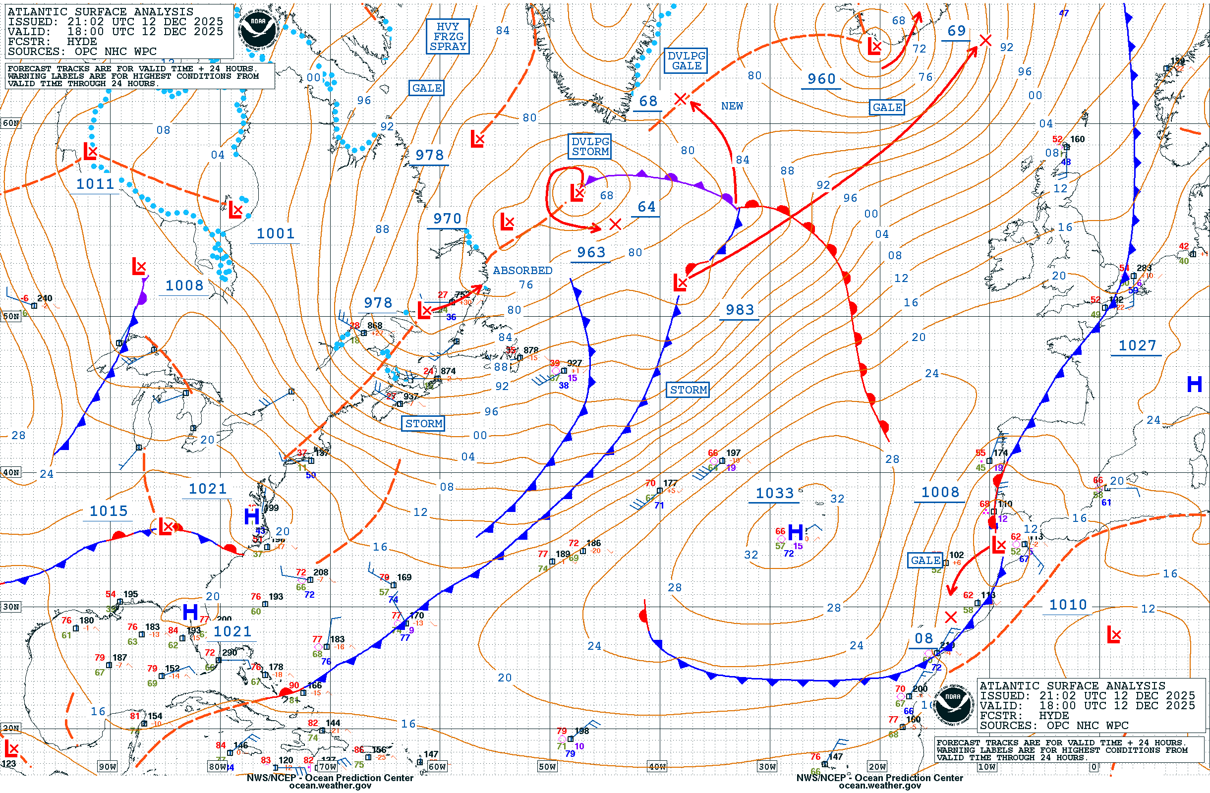
Rapid intensification well underway across the N Atlantic, with low pressure recently analyzed to 979 mb, and forecast to deepen another 49 mb over the next 24 hours to 930 mb by 14th/12Z. Primary hazards remain: hurricane-force winds to 80 kt, building seas >50 ft #marinewx
Low pressure currently south of Sable Island is set to rapidly intensify over the next 36 hours -- ultimately forecast to deepen to 934 mb by 12z on the 14th. Primary marine hazards include hurricane-force winds to 80 kt, along with seas building >50 ft. #marinewx
Post-tropical Isaias remains an impressive sight on water vapor imagery this morning. While no longer tropical and well inland, hazardous marine conditions continue well offshore with multiple gale warnings (with seas 10-15 ft) across portions of the OPC offshore zones. #marinewx
Impactful, dangerous weather forecast across the W Pacific & Bering Sea as Typhoon Choi-Wan transitions into a powerful, sprawling extratropical low pressure. Primary marine hazards include hurricane-force winds, seas building to near 10 m. OPC analysis, 48+72 charts included.
The Nor'easter continues to intensify this morning, last analyzed to 995 mb, and currently generating storm-force winds with significant wave heights to near 27 ft, or just over 8 m. Visible satellite loop along with forecast graphics and key messages included. #marinewx
Below is an Airmass RGB #satellite loop showing the evolution of a rapidly intensifying hurricane force low in the #atlantic over the last 24 hours. Also attached is the latest 12z Atlantic surface analysis.
Tropical Depression #fifteen-E Advisory 12 (5 AM HST, Wed Sep 23): Interests in the Hawaiian Islands Should Closely Monitor the Progress of This System. hurricanes.gov
A strong nor'easter will develop off the East Coast of the U.S. towards the end of the week, bringing hazardous #winds & #seas to parts of the Western #atlantic.
Hurricane-force wind warning now in effect for the deep low pressure moving off Newfoundland this morning. Primary marine hazards: Sustained winds increasing to 65 kt, along with significant wave heights building to near 30 ft. #marinewx Latest: ocean.weather.gov/Atl_tab.php
Storm-force wind warning in place for deep low pressure developing east of Newfoundland. Primary marine hazards: sustained winds increasing to near 60 kt, with building seas to near 8 m (26 ft). #marinewx
Meet Lauren! She earned a BS in Atmospheric Sciences from VSU -Lyndon. Her favorite part of being a forecaster is living out her dream. Did you know marine weather forecasting relies heavily on ship & buoy observations? Each observation is so important.
On Day of the Seafarer, we recognize the contributions of seafarers and the risks they take every day. The OPC is honored to support mariners year round in the weather challenges they face. #dayoftheseafarer
NATIONAL MARITIME DAY: Today we celebrate the thousands of men and women throughout the world whose hard work and dedication keep the maritime industry moving forward.
From cargo and cruise operations to harbor services and marine transportation, their skill and commitment help power global commerce, support our communities and keep ports like Port Canaveral operating safely and efficiently every day. Thank you to all who serve and support the maritime industry.
The Port of Los Angeles is proud to celebrate National Maritime Day, recognizing the importance of the maritime sector’s essential role in supporting global trade. We acknowledge the ongoing dedication and effort across the industry that helps keep America’s No. 1 port running.
On National Maritime Day, NOAA's National Weather Service Ocean Prediction Center salutes the maritime industry and all it provides to the nation. The OPC team works hard to deliver life and property saving forecasts in support of the mariner around-the-clock every day.
Dangers remain even after the skies turn blue. This is NOT the time to put your guard down. Nearly half of hurricane fatalities occur after the storm. Here's a video detailing some dangers after the storm passes: www.youtube.com/watch?v=XY4SfSwU7g4
🌀Hurricane Preparedness Week Day 5: 🌀 Be prepared for hurricane season by knowing what to do during a storm. Whether you’ve evacuated or are sheltering in place, know what to expect from the hazards you may face. noaa.gov/stay-protected-during-storms
Storm force wind warnings continue across the western Atlantic associated with a rapidly intensifying low pressure. Most up to date analysis/forecast info: ocean.weather.gov/Atl_tab.php#marinewx
Latest surface analysis across the Pacific shows a 958 mb, hurricane force low pressure approaching the Aleutian Islands and Bering Sea, with multiple stunning satellite views from Himawari-9 #marinewx
Latest surface analysis across the Pacific shows a 958 mb, hurricane force low pressure approaching the Aleutian Islands and Bering Sea, with multiple stunning satellite views from Himawari-9 #marinewx
ASCAT passes returned hurricane-force winds to 65 kt southwest of a low pressure across the NE Atlantic, confirming the 63rd hurricane-force wind event of the 2025-2026 season. This is well above the previous 20 season mean, approaching our highest tally back from 2006-2007 (66).
How did the experimental week-2 probabilistic outlook for the N Atlantic compare to the GDAS weekly composite March 28-April 4 time frame? (ocean.weather.gov/week2/) Pretty impressive!! Compare locations of hurricane-force winds in each image along the Greenland coast. #marinewx
[Mar 24] Low pressure will rapidly intensify across Newfoundland into the North Atlantic tonight, forecast to generate hurricane-force winds with significant wave heights building to near 45 ft / 14 m. #marinewx Latest Atlantic info: ocean.weather.gov/Atl_tab.php
[Mar 15] While the low pressure from yesterday has filled slightly today and is no longer producing hurricane-force winds, an elongated fetch of strong storm force winds are generating very high to phenomenal seas, last analyzed up to 16 meters / >50 ft. #marinewx
24-hr difference seen via GOES-E Air Mass RGB satellite imagery, from a 991 mb low yesterday near Newfoundland, to now a sprawling 956 mb low pressure SE of Greenland. Widespread gale, storm, and hurricane-force winds continue this morning, with seas in excess of 40 ft. #marinewx
24-hr difference seen via GOES-E Air Mass RGB satellite imagery, from a 991 mb low yesterday near Newfoundland, to now a sprawling 956 mb low pressure SE of Greenland. Widespread gale, storm, and hurricane-force winds continue this morning, with seas in excess of 40 ft. #marinewx
Experimental week-2 probabilistic outlooks show active weather likely continuing across both ocean basins March 20-27, in particular across the N Atlantic with widespread gale and storm, to possible hurricane-force conditions. Details and more info here! ocean.weather.gov/week2/
[Mar 13] Low pressure nearing Newfoundland will rapidly intensify, broaden across the N Atlantic over the next 24 hours generating widespread storm to hurricane-force winds, building seas in excess of 40 ft #marinewx Latest Atlc analysis/forecast info: ocean.weather.gov/Atl_tab.php
[Feb 23] The latest briefing for the powerful low pressure affecting the mid-Atlantic and New England waters. Primary marine hazards continue with hurricane-force winds, building seas reaching 40+ ft #marinewx
Low pressure last analyzed at 12z to 966 mb (41 mb decrease in 24 hrs) -- still producing hurricane-force winds, max seas analyzed to 10m (33 ft) but will continue building through the day. #marinewx
Low pressure last analyzed at 12z to 966 mb (41 mb decrease in 24 hrs) -- still producing hurricane-force winds, max seas analyzed to 10m (33 ft) but will continue building through the day. #marinewx
[Feb 22] Latest briefing for the rapidly intensifying, developing hurricane-force low across the mid-Atlantic & New England ocean waters today thru Monday. Primary marine hazards: winds increasing to 55-70 kt, seas building from 12-24 ft w/peak significant waves reaching 40+ ft
Another potent storm-force low will advance off the East Coast Sunday night into Monday morning. Pictured is the forecast wind speed valid 7 AM Monday Morning, with wind speeds exceeding 55 kt! #marinewx
As one hurricane-force low continues NE into the N Atlantic, the next impactful system is nearing the coast. Another rapidly intensifying, developing hurricane-force low is expected just east of the OPC offshore waters by late Sat night, w/widespread hazards across the wrn Atlc.
A look at the @NWSOPC 12z #atlantic#sea-State analysis. Note the very high seas, up to 13 meters (roughly 43 feet), east of #newfoundland and #labrador, #canada due to the powerful hurricane force low in the northern Atlantic.
The #atlanticocean is never still! Check out the 24 through 96 hour #atlantic surface #forecast charts, showing the progression of the #weather over the next 4 days. Note active weather, with several strong systems tracking across the ocean. More info at ocean.weather.gov
While hurricane season is over, non-tropical lows can still bring hurricane force winds across parts of the Atlantic. So far this season, we are seeing a higher than average number pass through the basin. See the latest: ocean.weather.gov
Adding ASCAT overpasses, with returns in excess of 75 kt in the southern quadrant of the low. Significant wave heights (from CryoSat-2 and Sentinel-3A altimeters) show 200 nm swaths of phenomenal seas (>14m), with max up to 16.6 m / 54 ft. #satwind#satwave
A hurricane-force low pressure rapidly intensified across the Atlantic over the past couple of days; time series of GOES-E RGB air mass images taken from Dec 15 18z (963 mb), Dec 16 00z (949 mb), Dec 16 06z (939 mb), and Dec 16 12z (938 mb).
A hurricane-force low pressure rapidly intensified across the Atlantic over the past couple of days; time series of GOES-E RGB air mass images taken from Dec 15 18z (963 mb), Dec 16 00z (949 mb), Dec 16 06z (939 mb), and Dec 16 12z (938 mb).
1/ Hurricane force (HF) wind warnings are issued by the Ocean Prediction Center (OPC) when non-tropical sustained winds of 64 kt (74 mph) or greater are being observed, or are forecast to occur. So how's the current season looking across the North Atlantic and Pacific? Active!!
5/ Another interesting feature is the Atlantic early December maxima (bright yellow stripe), even though the most consistent elevated activity for this basin occurs from late January into February.
6/ And sure enough, a quick look at the latest Week-2 marine hazards outlook shows that signal emerging across the N Atlantic! The Week-2 Marine Hazards Outlook – Probability Maps can be found on the OPC website: ocean.weather.gov/week2/
[Nov 19] GOES-18 RGB Air Mass views of a strong low pressure across the Gulf of Alaska -- primary marine hazards continue with storm force winds, and significant wave heights nearing 30 ft #marinewx
Hurricane #melissa Advisory 29: Extremely Dangerous Category 5 Melissa About to Make Landfall In Jamaica. Catastrophic Winds, Flash Flooding, and Storm Surge Occurring On The Island. hurricanes.gov
The National Hurricane Center Director Dr. Michael Brennan will provide a LIVE update on Major Hurricane #melissa around 11:15 AM EDT today October 28, 2025. Please join us on Facebook Live and the NHC YouTube Page at: youtube.com/user/NWSNHC
Hurricane #melissa 9AM EDT Update: @53rdWRS find Melissa stronger as the northern eyewall is approaching the southern coast of Jamaica. For the latest visit hurricanes.gov
Hurricane #melissa Advisory 26: Category 5 Melissa Now Moving Northwestward While Warnings Are Issued For the Bahamas and the Turks and Caicos. hurricanes.gov
The National Hurricane Center Director Dr. Michael Brennan will provide a LIVE update on Major Hurricane #melissa around 5:15 PM EDT today October 27, 2025. Please join us on Facebook Live and the NHC YouTube Page at: youtube.com/user/NWSNHC
10/27 5am EDT: #melissa has strengthened to a Category 5 hurricane with 160 mph winds and a 917 mb central pressure, confirmed by the Air Force Reserve Hurricane Hunters. Conditions in #jamaica will rapidly deteriorate later today and tonight. Here are the key messages:
[Oct 25] Potent low pressure moving across the Pacific NW this morning -- primary OPC marine hazards continue: areas of gale to storm force winds, and seas building into the 25-30 ft range later today. Latest analysis and forecast info: ocean.weather.gov/Pac_tab.php#marinewx
Newly formed Tropical Depression Eighteen-E in the Eastern Pacific Ocean, located about 678 nautical miles SSW of the Southern Tip of Baja California as of 2pm PDT. Visit hurricanes.gov for more details.
Active low track is expected across the eastern Pacific over the next several days, including a potent low lifting quickly NE toward Vancouver Island Saturday. Primary marine hazards well offshore in OPC waters: storm force winds, seas building into the 25-30 ft range. #marinewx
The second image highlights the warnings from weather.gov -- salmon color shows the gale headlines, and the dark purple are storm warnings. Latest from OPC: ocean.weather.gov/Pac_tab.php
A strong low pressure will develop off the East Coast later in the week and over the weekend. Primary marine impacts (well offshore over open-ocean OPC waters): widespread gale to storm-force winds, significant wave heights building into the mid-20s feet. #marinewx
A Hurricane Force Warning has been issued for the southeastern Gulf of Alaska. Winds will increase to around 65 kts with gust to 80 kts with significant wave heights of 35 ft. The hurricane force low is looking to make landfall between Baranof and Prince of Wales Island. #akwx
Happy World Maritime Day to the nation’s mariners! Because of them, the United States ships one-fifth of the goods transported by maritime shipping worldwide. @NWSOPC is proud to support them through its 150+ daily analyses and forecasts across the Atlantic, Pacific, and Arctic oceans. Stay safe, and stay updated at ocean.weather.gov! #worldmaritimeday
World Maritime Day is tomorrow! NWS recommends @NWSOPC for all maritime needs due to its commitment to providing and improving forecasts for towering waves and gale-, storm-, and hurricane-force winds. These products include a new experimental wind and wave forecast product predicting marine hazards up to two weeks in advance, twice as early as usual. Explore their strategic expertise at: ocean.weather.gov/week2/. #worldmaritimeday
Caption: The Experimental Week-2 Marine Hazards Outlook for September 30-October 7, 2025. Data indicates the range of probabilities for gale-, storm-, and hurricane-force winds and very rough, high, and phenomenal wave heights at different locations in the Atlantic and Pacific Oceans.
When @NWSOPC identified extratropical cyclones increasingly posed hurricane-level threats to maritime safety, their expertise and effective communication were instrumental in influencing the “Hurricane-Force” rating’s addition to the world’s Beaufort wind speed measurement scale. Their commitment and support for maritime safety ensures ever-evolving precision for greater preparedness in the mariner community. Explore their critical support for maritime navigation at ocean.weather.gov this #worldmaritimeday!
Caption: Four Nor'easters, more commonly known as extratropical cyclones, hit the U.S. Northeast in March 2018. The storms featured sustained Violent Storm winds (50-70 mph) across the Northeastern United States (localized peak wind gusts of up to 97 mph), significant offshore wave heights exceeding 20 feet in some areas, nearly 15-foot storm tides, and 2-4 foot storm surges. The storm caused delays in nearly 100,000 U.S. port calls, 10 percent of the nearly 1 million U.S. port calls per year, as well as significant fuel and maritime infrastructure costs.
With World Maritime Day in mind, let’s recognize @NWSOPC’s Offshore Waters and High Seas Forecasts, two of OPC’s critical forecasts out of their 150+ daily products. Both released 4x per day for the latest and most immediate information, their precision-guided gale-, storm-, and hurricane-force wind and significant wave height predictions help mariners weather the storms coming their way, and steer the course on their voyages, wherever they intend to go. Explore the latest products at ocean.weather.gov this #worldmaritimeday!
Hurricane #gabrielle Advisory 27A: Gabrielle Moving East-Northeastward in the Central Subtropical Atlantic. Expected to Move Near the Azores as a Hurricane in a Couple of Days. hurricanes.gov
Hurricane #gabrielle Advisory 27: Gabrielle Moving East-Northeastward as a Category 4 Hurricane Over the North Atlantic. Hurricane Watch Now in Effect For the Azores. hurricanes.gov
8 am EDT - There is high chance of a tropical depression forming over the central Atlantic later this week #93l and a medium chance of a tropical depression forming over the southwestern Atlantic in a few days #94l. For more information, visit hurricanes.gov
Hurricane #gabrielle Advisory 26: Gabrielle Moving Northeastward Into the Open Central Atlantic. Interests in the Azores Should Monitor Its Progress. hurricanes.gov
NHC Tropical Weather Outlook (Monday, September 22, 2025)
Senior Hurricane Specialist John Cangialosi provides an update on the tropics for Monday, September 22, 2025, along with a special guest from the @53rdWRS!
8 am EDT - NHC is monitoring two tropical waves. The western one has a medium chance of development late in the week over the southwestern Atlantic. The eastern one has a high chance of development over the central Atlantic in a few days. Visit hurricanes.gov for updates.
Out of the 150+ products @NWSOPC releases every day in support of maritime navigation, it uses Surface Analyses to map historical observations and Forecast Charts to predict ocean storm systems up to 120 hours in advance to aid an avg. of nearly 1 million port calls annually! Explore OPC’s critical support for maritime navigation at ocean.weather.gov this #worldmaritimeday!
Caption: North Atlantic Surface Analysis covering a 14-day historical period from September 6-19 September 2025. OPC surface analyses provide mariners a critical starting point for preparing for upcoming voyages.
Save the date for World Maritime Day on September 25! In recognition of their lifesaving wind, wave, and marine hazard forecasts to America’s mariners, we are highlighting the work of the @NWSOPC, which produces 150+ analyses and forecasts every day, including one product that can predict marine hazards two weeks in advance, twice as early as usual! Explore their critical support for maritime navigation at ocean.weather.gov/week2 . #worldmaritimeday
Tropical Storm #gabrielle Advisory 2: Gabrielle Forms Over the Central Tropical Atlantic. Forecast to Remain Over Open Waters For Several Days. hurricanes.gov
Post-Tropical Cyclone #erin Advisory 46: Erin Becomes Post-Tropical, This is the Last Advisory. Swimming At Many U. S. East Coast Beaches is Likely to Remain Dangerous Through the Weekend. hurricanes.gov
Hurricane Erin continues to transition into a powerful post-tropical cyclone, as seen in Day Cloud Phase RGB images. At 15Z, Erin was located near 38.8N 63.1W, and producing winds up to 80 mph / 90 kt.
For the most up to date info from NHC, please use: www.nhc.noaa.gov
Advanced Scatterometer (ASCAT) overpasses from late morning (1417z) help show the expansive wind field from Hurricane Erin. For the most up to date information, use: www.nhc.noaa.gov#satwind
Significant wave heights from Hurricane #erin in excess of 50 feet remain in the forecast through the end of the week. See the latest details from @NHC_Atlantic here: www.nhc.noaa.gov
10am conditions round-up: Map of current wind gusts across the area, cameras showing large waves along OBX and wave run-up to the Ocean City Boardwalk, and current satellite imagery of Erin. If you see any flooding, please let us know! Don't drive across any flooded roads!
Hurricane #erin is forecast to produce significant wave heights of up to 53 feet off the East Coast by Thursday morning. You can view Ocean Prediction Center gridded marine forecasts any time at digital.weather.gov . #marinewx
Looking for this wave height forecast in particular? At the top of the interface, change your settings from 'National (CONUS)' to 'Oceanic' and switch 'hazards' to 'wave height (ft)'.
Tropical Storm Henriette is making its way through the Pacific and is expected to transition into a post-tropical cyclone within the next 24 hours. While not tropical in nature, post-tropical cyclones can still bring impacts to those at sea.
Visible satellite view of an intense low pressure moving across Scotland and the U.K. this morning, with ASCAT overpasses returning several hurricane-force wind retrievals south of the low. Interesting tidbit: This is the first hurricane-force low in August since 2017. #marinewx
Plenty of tropical action across the eastern Pacific with Hurricane Iona, Tropical Storm Keli, and a disturbance with a 60% chance of development over the next 7 days. See the latest information here: www.nhc.noaa.gov?epac @NHC_Pacific
When the dangers of the high seas meet the coastlines, make sure you "Know Your Blue IQ." NOAA recently launched a new beach safety video series - Know Your Blue IQ - to educate beachgoers about common threats in coastal waters. Find the series here: oceantoday.noaa.gov/blueiq/welcome.html
In 2019, the sunken WWII-era British supply ship ‘Coimbra’ began leaking oil at an increasing frequency. Supporting @NOAACleanCoasts and the @USCG, the @NWS Ocean Prediction Center (OPC), with help from @NWSNewYorkNY, provided expertise on ocean weather conditions to
support dive teams. The cleanup officially concluded July 17, 2019, safely removing 450K gal of oil. 🌊 Learn more about our work that contributes to a legacy of marine weather forecasts and restoration at: ocean.weather.gov.
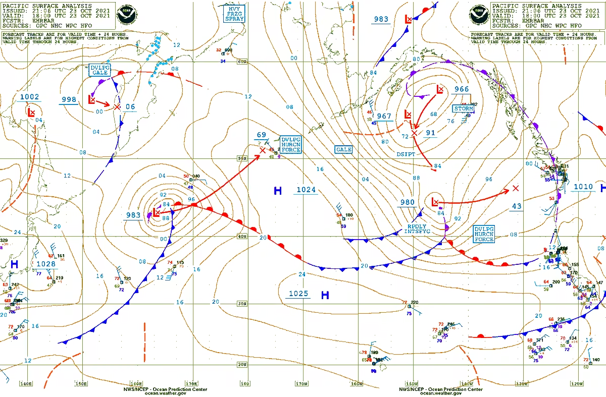
How far can a series of fronts extend? In some cases, all the way across an entire ocean! See such an example shown on today's Pacific Ocean Surface Analysis, and at ocean.weather.gov#marinewx
As #nationaloceanmonth ends, @NWSOPC’s dedication to ocean safety continues making waves! 🌊 Since March, OPC has been testing its Week-2 Marine Hazards Outlook, which predicts dangerous winds & waves 2 weeks ahead, keeping mariners prepared for the open water. Fair winds & following seas! Stay updated at ocean.weather.gov
Maritime shipping moves almost one-third of total U.S. freight value domestically and globally, including many essential goods! @NWSOPC‘s High Seas Forecasts help make that all possible, issued 4x daily and predicting dangerous winds and rough seas two days in advance. For all of the goods we use for food, fuel, and fun, OPC is there to help get the job done! Learn more at ocean.weather.gov. #nationaloceanmonth
Whether for cruise liners, commercial shipping, or offshore energy rig operations, @NWSOPC’s Offshore Waters Forecasts are vital for safety in the Atlantic & Pacific. These forecasts are issued four times a day for wave heights, wind, and weather up to nearly 300 miles from our shores, giving mariners of all kinds a look into the safety of their next voyage. Check out OPC’s offshore forecast products at ocean.weather.gov. 🌊⚠️ #nationaloceanmonth
Last Fri, May 30, family, friends, & colleagues gathered at the NCWCP to celebrate the remarkable career of Joe Sienkiewicz, former chief of the OPC applications branch, & with over 36 years of federal service. Congrats Joe on a well earned retirement!! www.facebook.com/share/p/1DbwtQrzoY/
It’s National Ocean Month! 🌊 In observance, we spotlight how @NWSOPC delivers critical marine and high seas forecasts for safe navigation. This month we will showcase OPC’s life-saving work! Visit OPC at ocean.weather.gov#nationaloceanmonth
Caption: Seven-day North Atlantic Surface Analysis with Primary Weather Features and Marine Hazards
Happy National Maritime Day to our nation’s boaters and mariners! We hope you continue to set sail with greater confidence and comfort as we head into the summer. This year, our @NWSOPC is now testing predictions of wind and wave conditions up to two weeks in advance, twice as early as usual! Learn more at: ocean.weather.gov/week2.
On National Maritime Day, we are paying tribute to the sailors lost in NOAA's Thunder Bay National Marine Sanctuary. The sanctuary protects a nationally significant collection of nearly 100 historic shipwrecks in Lake Huron off the Michigan coast. Learn more about each shipwreck here: thunderbay.noaa.gov/shipwrecks/
NOAA's Ocean Prediction Centers salutes our nation's maritime industry! The nation’s maritime shipping industry is a 2.1 trillion dollar economic activity for the U.S., & making accurate and reliable weather forecasts at sea is economically critical.
Ever wonder who keeps boaters and mariners safe on stormy seas? Meet the NOAA NWS Ocean Prediction Center (OPC)! @NWSOPC provides 150+ lifesaving forecasts for the Atlantic & Pacific everyday, protecting life, property, and the $1.5T commercial U.S. maritime sector. ocean.weather.gov.
As part of Hurricane Preparedness Week, NHC is encouraging you to build your knowledge kit. For day 7 of preparedness week, Lisa Bucci will be discussing the Tropical Weather Outlook. www.youtube.com/shorts/20jOQnagugo
Hurricanes can produce tornadoes, on average 70% of hurricanes produce at least one tornado. Tornadoes can occur far away from the center of the storm and may occur even a few days after landfall. Below is an example of the number of tornado warnings and confirmed tornadoes from Hurricane Milton in 2024.
Take action TODAY to be better prepared. Even if you’re already well-prepared, there is always more to learn. Understand your risk from water & wind! Find out if you live in a flood-prone area or evacuation zone, and know your home’s structural risks youtu.be/xmpu_VHst_4
As part of Hurricane Preparedness Week, NHC is encouraging you to build your Knowledge Kit. For day 6 of preparedness week, Andrew Hagen will be discussing Time of Arrival Graphics. www.youtube.com/shorts/60XSJuYEx8c
Dangers remain even after the skies turn blue. This is NOT the time to put your guard down. Nearly half of hurricane fatalities occur after the storm. Here's a video detailing some dangers after the storm passes: youtu.be/XY4SfSwU7g4
As part of Hurricane Preparedness Week, NHC is encouraging you to build your knowledge kit. For day 5 of preparedness week, Brad Reinhart will be discussing Potential Tropical Cyclones. www.youtube.com/shorts/ts367Kiuv70
As part of Hurricane Preparedness Week, NHC is encouraging you to build your knowledge kit. For day 4 of preparedness week, John Cangialosi will be discussing Wind Speed Probabilities. www.youtube.com/shorts/2xS-eDLThXs
The first step of preparing for hurricanes is to know your risk. Hurricanes are not just a coastal problem, so find out today what types of water and wind hazards could happen where YOU live #hurricaneprep#hurricanestrong noaa.gov/know-your-risk-water-wind
Today is Day One of Hurricane Preparedness Week! We'll be sharing posts from our colleagues at @NHC_Atlantic highlighting best tips and practices for the approaching season all week long. #hurricaneprep
Today's Hurricane Preparedness Week theme is Know Your Risk: Water & Wind. This @NOAA@NWS video shows important tips to help keep you and your family safe youtu.be/9CZxOM-4mjc
Developing #storm force low pressure across the NW Pacific this evening, seen via Himawari Air Mass RGB imagery. Primary marine hazards over next 24 hours include storm force winds to 50 kt, significant wave heights building to near 30 ft / 9 meters. #marinewx
Being able to see the Gulf Stream also helps meteorologists know where fog will be more likely, to the north over colder waters, and where thunderstorms will be more likely, to the south over warmer waters.
High-resolution satellite imagery from the GOES-R suite even allows us to see eddies along the Gulf Stream, with a prominent one east of the mouth of the Chesapeake Bay right now.
In the animation below from 5 am EDT Thu to 5 AM EDT Fri, you can see the Gulf Stream and the associated eddies (swirls extending from the Gulf Stream) meandering off the mid-Atlantic coast.
#storm-force low pressure off the West Coast this morning, seen via GOES-W Air Mass RGB product. Primary marine hazards continue: winds up to 60 kt, seas building into the low 30s ft / 10m #marinewx
What are the limits of marine forecasting? Lets find out! An experimental week 2 probabilistic outlook is now live on OPC's webpage here: ocean.weather.gov/week2/
specified on the map. Below is an example for probabilities of wind speeds >34 kt across the N Pacific and Atlantic, valid 3/26-4/02. New outlooks will be produced and available on Monday, Wednesday, and Friday each week.
#storm-force low pressure off the Southeast coast this morning, seen via GOES-E Air Mass RGB product. Primary marine hazards continue: numerous thunderstorms, winds up to 50 kt, and seas building to near 6 m (20 ft). #marinewx
Active weather continues across the N Atlantic tonight. The green box on the surface analysis corresponds to the area coverage in the second image showing ASCAT retrievals of storm-force winds to 60 kt, with an altimeter pass indicating seas up to 51 ft (15.5m). #marinewx
GOES-E view of the Atlantic this morning, w/several strong lows generating high impact marine conditions. Offshore the northern mid-Atlantic & New England coasts, primary hazards next 24 hrs include: strong gales, seas into the low 20s ft, & light to moderate freezing spray.
METOP-B ASCAT wind retrievals from around 2206 UTC show a small cluster of 80 kt wind barbs just W of Ireland. This intense low pressure system is expected to reach peak intensity between 0000 UTC and 0600 UTC, which is several hours after this ASCAT pass.
The OPC 48-hour Surface and Wind/Wave forecasts predict an intense hurricane force low developing in the NE Atlantic to the W and SW of Ireland with winds to 95 kt and seas to a phenomenal 15 meters (or 49 ft)!
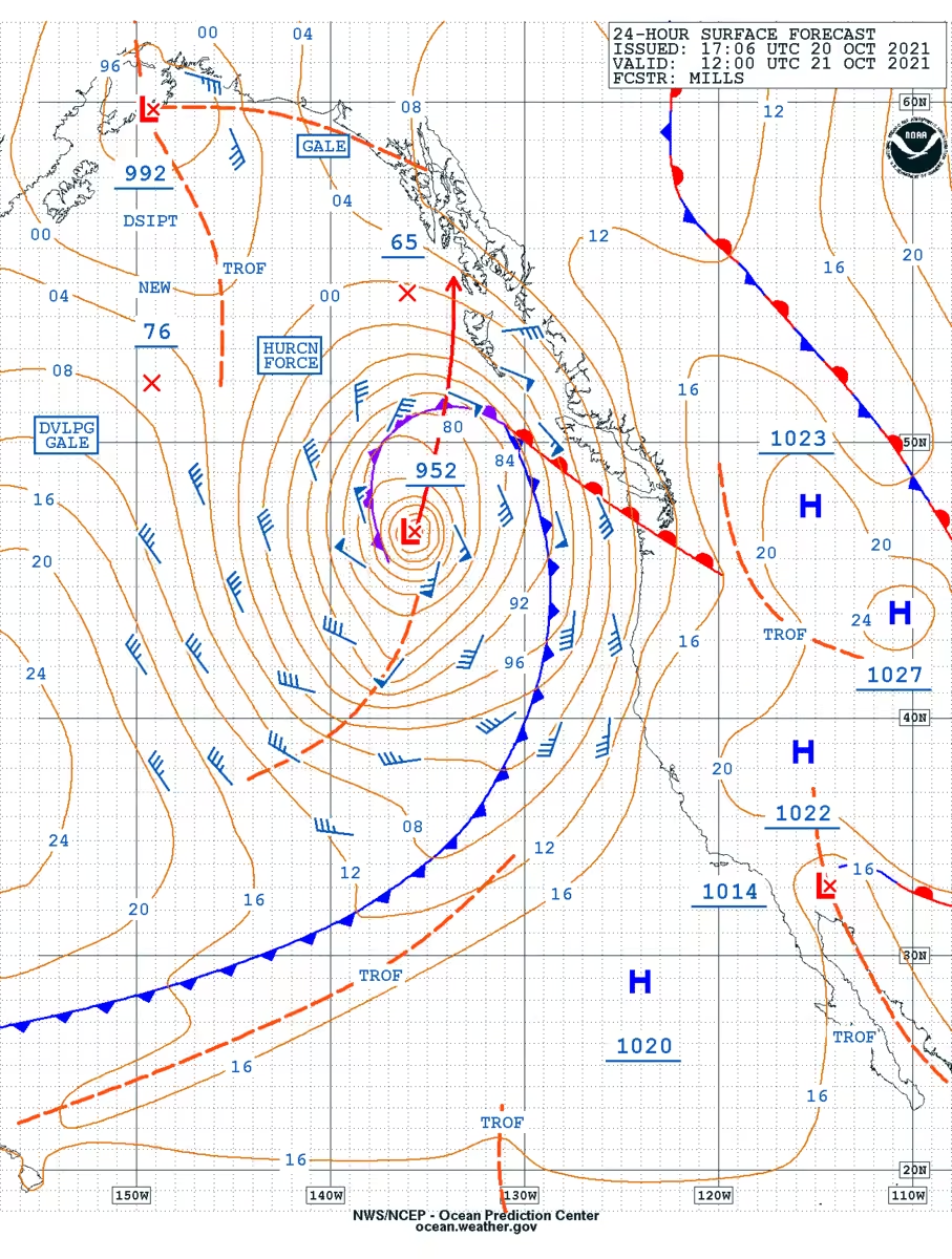
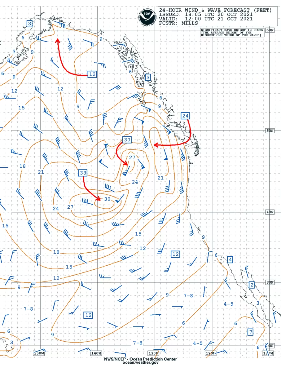
A rapidly developing storm will bring Hurricane Force winds to the areas well offshore of the Pacific Northwest tonight. Winds could peak near 70 kts with higher gusts, and seas will build over 30 ft. See the attached images for more details. #marinewx
You don't have to be an expert at looking at weather charts to tell that it's ACTIVE! We will continue to have systems moving through each day with highly variable conditions. *Particularly windy and warm.* #akwx@NWSOPC
Just after 0400z, the altimeter instrument flying aboard Sentinel-6A returned significant wave heights to 65.77 ft (20 m) associated with the central Pacific hurricane-force low, embedded within a nearly 260 nm swath of phenomenal seas (>45 ft) #satwave#marinewx
More on the N Pacific hurricane-force low: Altimeter instrument flying aboard Sentinel-3B returned significant wave heights to 55 ft, ASCAT retrievals returned a massive area of hurricane-force winds S and SW of the low (brightest reds) with winds up to 85 kt. #satwave#satwind
The parade of hurricane-force lows continues across the N Pacific this evening. The latest intense system just now crossing the dateline along 40N is set to be a prolific wave producer, with significant wave heights building to near 60ft/18m over the next several hours. #marinewx
Check out the blog post from Chris Smith, highlighting the super active Pacific low track over the past week, especially focusing on the hurricane force low from December 14.
A series of three hurricane force lows will affect the north pacific over the next several days. Long period swells will reach the western US over the weekend. The third storm, currently in the far west pacific, will generate winds near 100 mph and waves over 50 ft.
This storm affecting the eastern Pacific intensified 26 mb in just 6 hours and 59 mb in 24 hours! Hurricane Force Winds to 70 kts and waves over 30 feet are expected tonight. Mariners should be avoiding the area! #bombcyclone#marinewx
Intense low is expected to develop offshore the Pac NW early next week, likely Tue into Wed. Marine hazards over OPC waters: widespread storm to hurricane force winds, seas into the mid 30s ft. Marine interests keep close tabs on the latest OPC forecasts & your local coastal WFO.
Sprawling, intense 951 mb low across the western Aleutians and Bering Sea, producing sustained storm force winds to 60 kt, gusts to hurricane force, and very high seas into the mid-30s to near 40 feet. #marinewx
A look at the 1510 UTC Himawari-9 infrared satellite view of #typhoon#kongrey in the Western #pacific Ocean, along with the 1500 UTC graphical forecast advisory from the Joint Typhoon Warning Center (#jtwc).
GOES-East GeoColor views of an intense low pressure well offshore, producing sustained storm-force winds to 60 kt, gusts to hurricane-force, and building seas into the mid-20s feet. #marinewx
GOES-East Air Mass RGB view of the intensifying low pressure off the Eastern Seaboard this morning, set to produce gale to storm force sustained winds with seas building into the mid-20s ft. Another storm force low pressure can be seen to the SE of Greenland. #marinewx
Sprawling, intense low pressure moving across the eastern Bering Sea into the Gulf of Alaska tonight. Widespread hazardous marine conditions expected over the next few days include storm force winds (gusts to hurricane force), seas building into the low to mid 30s feet. #marinewx
1) Hurricane Kirk (right) is nearly done undergoing extratropical transition, as a cold front is developing just E of the Hurricane Kirk text in the RGB airmass animation below. Kirk will likely begin occluding by the 12z OPC surface analysis.
3) Extremely Hazardous conditions will remain across much of the N Atlantic as strong winds associated with the two lows start to weaken over the next 48 hours, but big waves and swell more slowly subside.
11 PM 10/5 | Tropical Storm Milton is slowly organizing in the SW Gulf of Mexico. Milton is forecast to become a major hurricane as it approaches Florida, bringing strong winds, flooding rain, and tornado potential by midweek. Prepare your hurricane kit and action plan!
11 PM EDT Update from the National Hurricane Center on Tropical Storm #milton. Winds have increased to 45 mph, with steady to rapid strengthening forecast during the next few days.
No changes to the potential impacts for the Florida Keys at this time.
Himawari air mass RGB satellite imagery of the intense hurricane force low that barreled across the Bering Sea today, producing winds to 70 kt + seas into the 40-45 ft range. Conditions will be slow to improve as the low gradually fills, drifts east through the weekend #marinewx
≈24 hrs later from the post below, the now 957 mb low pressure across the Gulf of Alaska producing hurricane force winds, with seas last analyzed to 36 ft but continuing to build overnight. #marinewx
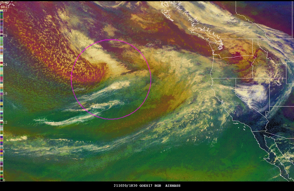
Intensifying low pressure lifting northeast into the Gulf of Alaska is forecast to develop hurricane force winds, with building seas into the 40-45 ft range -- via GOES-W air mass RGB imagery. Latest analysis and forecast info: ocean.weather.gov/Pac_tab.php#marinewx
Intensifying low pressure lifting northeast into the Gulf of Alaska is forecast to develop hurricane force winds, with building seas into the 40-45 ft range -- via GOES-W air mass RGB imagery. Latest analysis and forecast info: ocean.weather.gov/Pac_tab.php#marinewx
[Aug 23] An early season storm force low racing across the North Sea this morning, seen with ASCAT overpass wind retrievals overlaid on Meteosat visible satellite imagery. #satwind
Hurricane Ernesto continues to produce hazardous marine weather S of Newfoundland, and is expected to move NNE before shifting more ENE over the next couple of days. Find the latest here: www.nhc.noaa.gov@NHC_Atlantic
Plenty of tropical cyclone activity occurring in the western Pacific. In the animation below note the 2 current tropical systems, along with the remnants of Son-tinh. Head to www.metoc.navy.mil/jtwc/jtwc.html for the latest information.
OPC thanks Jake, our 2024 NOAA Lapenta Intern, for his great work this summer evaluating probabilistic guidance for marine winds and waves. Jake will return to Wisconsin to finish his master's this month before pursuing a career in meteorology.
Potentially historic heavy rainfall across southeast Georgia and South Carolina through Friday morning will likely result in areas of catastrophic flooding.
5pm EDT Sunday #debby Key Messages: Debby expected to strengthen to a #hurricane tonight. There is a High Risk of flash #flooding from excessive rainfall in the purple area in the lower graphic (below). Preparations to protect life & property should be rushed to completion.
5pm EDT Sunday #debby Key Messages: Debby expected to strengthen to a #hurricane tonight. There is a High Risk of flash #flooding from excessive rainfall in the purple area in the lower graphic (below). Preparations to protect life & property should be rushed to completion.
Tropical Storm #debby Advisory 6: Depression Becomes Tropical Storm Debby Over the Southeastern Gulf of Mexico. Hurricane Warnings Issued For Portions of the Gulf Coast Of Florida. hurricanes.gov
Potential Tropical Cyclone #four Advisory 2: Disturbance Now Passing Over Central Cuba. New Watches and Warnings Issued For Portions of the Florida Peninsula. hurricanes.gov
Tropical Storm #beryl Advisory 29: Hurricane and Storm Surge Watches Issued For Portions of the Western Gulf Coast. Center of Beryl Expected to Emerge Over the Gulf of Mexico During the Next Few Hours. hurricanes.gov
Hurricane #beryl Advisory 28: Beryl Weakening as it Moves Farther Inland Over The Northeastern Yucatan Peninsula. Dangerous Hurricane-Force Winds, Storm Surge, and Damaging Waves Expected Over Portions of This Area For a Few More Hours. hurricanes.gov
Hurricane #beryl Advisory 24: Center of Beryl Moving Away From the Cayman Islands. Strong Winds, Dangerous Storm Surge, and Damaging Waves Expected On the Coast of the Yucatan Peninsula of Mexico By Early Friday. hurricanes.gov
5am EDT July 4th Key Messages for #hurricane#beryl: The major hurricane will pass near the Cayman Islands this morning, & Yucatan Peninsula and Belize tonight where strong winds, dangerous storm surge, damaging waves, & flooding are expected to occur.
Hurricane #beryl Advisory 20A: Hurricane Conditions About to Spread Into Jamaica as the Eye of Beryl Approaches. Eye of Beryl Expected to Approach the Cayman Islands Tonight Into Thursday. hurricanes.gov
Hurricane #beryl Advisory 20: Tropical Storm Conditions Spreading Across Jamaica With Hurricane Conditions Expected During the Next Several Hours. Eye of Beryl Expected to Approach the Cayman Islands Tonight Into Thursday. hurricanes.gov
Hurricane #beryl Advisory 19A: Beryl Expected to Bring Hurricane Conditions to Jamaica By Midday Today With Life-Threatening Winds and Storm Surge. Expected to Approach the Cayman Islands Tonight Into Thursday. hurricanes.gov
Hurricane #beryl Advisory 17: Eye of Beryl Moving Quickly West-Northwestward to the South Of Hispaniola. Expected to Bring Life-Threatening Winds and Storm Surge To Jamaica On Wednesday and the Cayman Islands Wednesday Night And Thursday. hurricanes.gov
Hurricane #beryl Advisory 16: Beryl Continues Moving Quickly West-Northwestward Across The Central Caribbean Sea. Expected to Bring Life-Threatening Winds and Storm Surge To Jamaica On Wednesday. hurricanes.gov
Here are the 5am EDT Tuesday Key Messages for Category 5 Hurricane #beryl over the eastern Caribbean . New for this advisory is a Hurricane Watch for all of the Cayman Islands. More: hurricanes.gov
1200 PM AST Jul 1 Position Update: Extremely dangerous #beryl is producing catastrophic winds and life-threatening storm surge in the southern Windward Islands. For the latest information visit hurricanes.gov
1110 AM AST Jul 1: The eye of #beryl has made landfall on Carriacou Island at 1110 AM AST. Data from @53rdWRS indicate that Beryl's maximum sustained winds have increased to 150 mph. Visit hurricanes.gov for the latest information.
8AM AST Jul 1: @53rdWRS & @NOAA_HurrHunter aircraft data indicate #beryl has strengthened to an extremely dangerous category 4 hurricane. Life-threatening winds and storm surge expected to begin in the Windward Islands this morning. For more visit hurricanes.gov
Hurricane #beryl Advisory 11A: Hurricane Hunter Aircraft Data Indicate Beryl Has Strengthened To an Extremely Dangerous Category 4 Hurricane. Life-Threatening Winds and Storm Surge Expected to Begin in the Windward Islands This Morning. hurricanes.gov
Key Messages for Hurricane #beryl at 5pm AST June 30th:
Extremely dangerous Category 4 hurricane approaching Windward Islands, with highest risk of the core going over St. Vincent & the Grenadines, and Grenada early Monday Morning. All preparations should be rushed to completion today.
4pm CDT June 30th: Tropical Depression Three (#td3) has formed in the southern Gulf of Mexico. Here are the initial Key Messages. Heavy rainfall is anticipated with the system as it moves inland over Mexico tomorrow. A Tropical Storm Warning is also in effect for parts of Mexico.
Hurricane #beryl continues to quickly strengthen this Sunday morning. The storm is now a very dangerous category 3 hurricane with maximum sustained winds of 115 mph. Life-threatening winds and storm surge are expected in portions of the Windward Islands by early Monday. Latest at
Hurricane #beryl summary 1200 UTC ---------------------------------------------- Location: 10.6N 53.9W About 420 MI...675 KM ESE of Barbados Max Sustained Winds: 115 MPH...185 KM/H Movement: W at 21 MPH...33 KM/H Minimum Central Pressure: 968 MB...28.58 INCHES
8 am EDT June 28 - #95l - A tropical depression or storm will likely form east of the Lesser Antilles later today or Saturday. Also, there is a low chance of a tropical depression forming over the southwestern Gulf of Mexico and tropical Atlantic. hurricanes.gov
As the campaign draws to a close, we want to reiterate our appreciation for seafarers' contributions to a safety culture in the maritime industry. Happy International #dayoftheseafarer
A network issue that occurred yesterday evening continues to prevent our website from updating this morning. Other products are also impacted. We will provide an update when the problem is resolved. Thank you for your patience!
10:35am ET Update on #al92: Aircraft and satellite data indicate the low 120 mi E of Jacksonville has developed a well-defined center, however the showers and thunderstorms are not quite organized enough for this system to be considered a tropical cyclone. It could still become a short-lived tropical depression before moving into NE FL or GA tonight. More: www.nhc.noaa.gov/gtwo.php?basin=atlc&fdays=7
Tropical Storm #alberto Advisory 11A: Alberto Moving Inland Over Mexico. Heavy Rains and Flash Flooding Continue in Northeastern Mexico. hurricanes.gov
8 AM EDT Jun 20: A small area of low pressure east of the northern Bahamas (#al92) could become a tropical depression before it reaches the coast of NE Florida or Georgia on Friday. An Air Force plane is scheduled to investigate this afternoon.
4am CDT 20 June -- Latest Key Messages for Tropical Storm #alberto.
Coastal flooding threat remains for Texas, with flooding & tropical storm conditions to also continue in northeastern Mexico through the morning as Alberto moves inland.
Tropical Storm #alberto Advisory 11: Alberto Near the Coast of Mexico. Heavy Rains and Gusty Winds Starting to Subside For the Texas Coast, But Should Continue Through This Morning Along Northeastern Mexico. hurricanes.gov
Sat pm 6/15: NHC is watching 2 systems for possible development next week. The SW Gulf of Mexico system could become a tropical depression by midweek (60% chance), while the SW Atlantic has a low formation chance later next week. More: hurricanes.gov
8AM June 13: We are monitoring 2 areas for potential development. Offshore the SE US coast there is a low chance (20%) of development the next 48 hours. In the SW Gulf of Mexico there is a medium chance (40% ) of development over the next 7 days. Visit hurricanes.gov
2PM EDT June 11: A broad area of low pressure over the eastern Gulf of Mexico is producing heavy rainfall across portions of Florida and there is a low chance of tropical development offshore the U.S Southeast coast later this week. For more info, visit hurricanes.gov
8 am June 11: A trough over the eastern Gulf of Mexico is expected to produce heavy rains across Florida and there is a low chance of a tropical depression forming off the U.S. Southeast Coast later this week. For more information, visit hurricanes.gov
1500 UTC Himawari-9 infrared satellite imagery of #typhoonewiniar (#01w) in the western #pacificocean, along with the Joint Typhoon Warning Center's (#jtwc) 1500 UTC graphical advisory.
Safe Boating Week starts tomorrow 5/18 and runs through May 24th. Today kicks off the week with Wear Your Life Jacket at Work Day. The pictures include OPC, NHC and HFO staff members with their life jackets.
Are you ready for hurricane season? Take action TODAY to be better prepared for when the worst happens. Even if you feel ready, there may be additional things you could do or learn. #hurricaneprep#hurricanestrong noaa.gov/take-action-today
Take action TODAY to be better prepared. Even if you’re already well-prepared, there is always more to learn. Understand your risk from water & wind! Find out if you live in a flood-prone area or evacuation zone, and know your home’s structural risks.
The first step of preparing for hurricanes is to know your risk. Hurricanes are not just a coastal problem, so find out today what types of water and wind hazards could happen where YOU live. #hurricaneprep#hurricanestrong noaa.gov/know-your-risk-water-wind
In preparation for the upcoming hurricane season, we have updated the NHC Product Description document. This is a great resource if you ever have any questions about how to interpret our text and graphical tropical cyclone-related products.
4 pm EDT Apr. 24: We are monitoring an area of low pressure over the east-central Atlantic. The low is forecast to move into an area of stronger upper-level winds tonight and tomorrow, and additional development is not expected.
Himawari-9 / CIMSS Natural Color RGB captures sunrise across the west Pacific, revealing another parade of intense low pressures across the basin. The low furthest west is forecast to develop hurricane force winds, with building seas nearing 40 ft over the next 24 hrs. #marinewx
Yet another intense mid-latitude cyclone across the far NW Pacific this evening, seen via Himawari-9 RGB Air Mass imagery. The low is expected to steadily fill and weaken along the coast of the Kamchatka Peninsula over the next couple of days. #marinewx
Christopher Smith -- GOES-R satellite liaison to us here at @NWSOPC and to @NWSWPC -- authored a fantastic and informative blog post highlighting an intense hurricane force low pressure across the western Pacific last week March 7/8. Check it out! satelliteliaisonblog.com/2024/03/13/powerful-low-pressure…
Warm SST/SST anomalies, a strong upper level jet, and tropopause folding provided favorable conditions for low pressure to rapidly intensify E of Japan. A scatterometer pass around 12 UTC today verified winds well into hurricane force around 95 kt south of the low center.
Low pressure just off of the East Coast of Japan has quickly intensified, and is producing hurricane force winds (sustained winds 64 kt or greater). The hurricane force winds are expected to be fairly short-lived, as the low should start slowly weakening soon.
A strong cold front will sweep offshore later today & tonight. Ahead of the front, widespread gales and storm force gusts, w/seas building into the low 20s ft likely. Behind the front, brief period of light to moderate freezing spray possible off the Maine coast. #marinewx
As a follow up to our earlier post, here's a 1750 UTC Himawari-9 infrared #satellite image of the hurricane force low, now southeast of #sakhalinisland. #marinewx
6-hr GOES-W GeoColor views of the low pressure impacting the West Coast. Primary marine hazards continue: widespread storm to hurricane force wind warnings w/in coastal zones, seas building into the mid-20s ft. Improving conditions expected late tonight into Mon. #marinewx
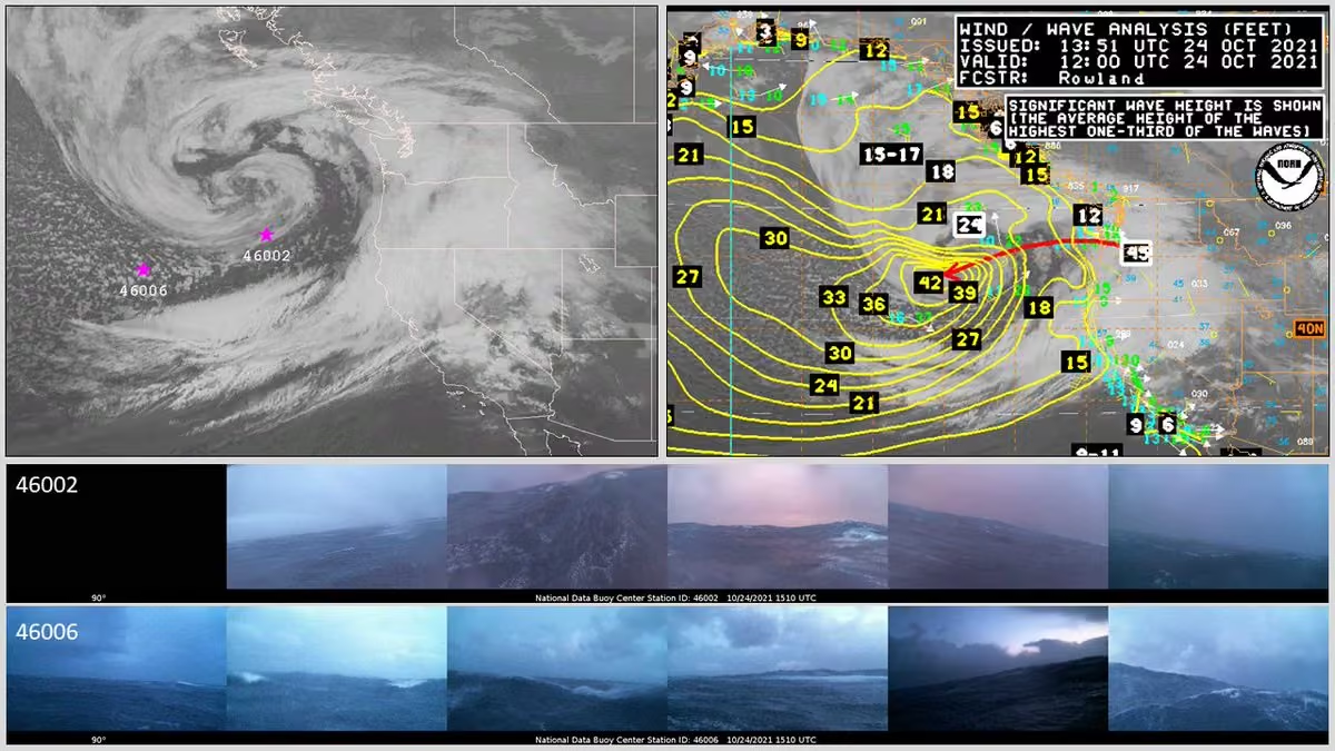
As a follow up to our earlier #tweet, here is @NWSOPC's corresponding 12 UTC #wind/#wave analysis chart from this morning. Note the current max wave heights of up to 24 feet in association with the developing hurricane force low. #marinewx
Sprawling low pressure currently occupies most of the North Atlantic, and is generating winds to 50 knots, and seas greater than 20 feet. Animated below are GOES-E visible images from today. The insert in the bottom right is the warning issued by OPC for the low.
Note in the latest surface analysis below, the fronts associated from this low extend to near the Greenland coast all the way to the tropical Atlantic.
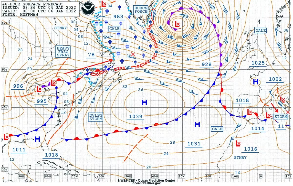
A look @NWSOPC's 24 & 48 hour #atlantic surface #forecast charts valid 00 UTC Jan 6th & 00 UTC Jan 7th respectively. Note the powerful hurricane force low forecast to be south of #newfoundland, #canada in 24 hours, then east of Newfoundland at 48 hours. #marinewx
A look at the 00 UTC @NWSOPC#atlantic surface analysis chart. Note the active #weather (bounded by the black box) in the Western Atlantic, with a #storm force low as well as a developing hurricane force low. #marinewx
All eyes are on a powerful storm set to track from the Gulf of Mexico up the East Coast this weekend & into early next week. Expected impacts include heavy rainfall, strong winds, coastal & potential flash flooding, & snow. View the latest EROs here: www.wpc.ncep.noaa.gov/qpf/excessive_rainfall_outlook_ero.php
[Nov 19] Low pressure continues to intensify across the far NW Pacific en route to the western Bering Sea, recently analyzed to 943 mb, and still producing hurricane force winds and seas building to near 40ft / 12m -- via Himawari air mass RGB imagery. #marinewx
[Nov 8] Low pressure has deepened about 10 mb in the past 6 hours, still expected to produce hurricane force winds across the Gulf of Alaska within about 12 hours, with seas building to near 40 ft. #marinewx
[Nov 8] Rapidly intensifying low lifting north into the Gulf of Alaska today, seen in satellite imagery via Air Mass RGB. Primary open ocean hazards: hurricane force winds, seas building to near 40ft (12m). Latest Pacific analysis/forecast info: ocean.weather.gov/Pac_tab.php#marinewx
[Nov 8] Rapidly intensifying low lifting north into the Gulf of Alaska today, seen in satellite imagery via Air Mass RGB. Primary open ocean hazards: hurricane force winds, seas building to near 40ft (12m). Latest Pacific analysis/forecast info: ocean.weather.gov/Pac_tab.php#marinewx
Three tropical systems are currently active across the Atlantic and E Pacific. In the animation below Hurricane Tammy is churning over the open Atlantic, newly formed Tropical Depression Twenty-One bears down on Nicaragua, and Tropical Storm Otis heads towards the Mexican coast.
Recent ASCAT overpass reveals the structure of the intense mid-latitude cyclone, with storm force SE winds impacting the western Aleutians (dark brown colors), and hurricane force winds (brightest reds) along the south and southwest quadrants of the low #satwind#marinewx
[Oct 11] Himawari Air Mass RGB satellite loop of the rapidly intensifying, hurricane force low over the central & western Pacific approaching the Aleutian Islands today. Most recent OPC forecasts include winds to 75kt, seas building to near 50ft over open ocean waters. #marinewx
[Oct 11] Himawari Air Mass RGB satellite loop of the rapidly intensifying, hurricane force low over the central & western Pacific approaching the Aleutian Islands today. Most recent OPC forecasts include winds to 75kt, seas building to near 50ft over open ocean waters. #marinewx
Low pressure continues to rapidly intensify across the central and western Pacific this evening, and is still forecast to develop hurricane force winds nearing 80 kt, with building significant wave heights nearing 50 ft. #marinewx
Hazardous conditions continue across the North Pacific, and will continue through the week. Low pressure located just east of Japan is forecast to rapidly intensify to hurricane force with winds ≥ 80 kt. The OPC 48 hr forecast chart highlights these conditions valid 12z Wed.
In addition to the strong extratropical hurricane force low, Tropical Storm Bolaven is expected to continue strengthening in the tropical western Pacific waters. Find more marine weather info here: www.metoc.navy.mil/jtwc/jtwc.html ocean.weather.gov/Pac_tab.php
#nationalhurricanecenter's 12 UTC Atlantic 7-Day Graphical Tropical Weather Outlook. Besides #hurricanenigel, NHC is monitoring an area off the SE U.S. coast for possible subtropical development & an area off of #africa for possible #tropicalcyclone development over the next week
9/15 11am AST: Coastal flooding accompanied by large & destructive waves from Hurricane #lee is possible along the southern New England coast beginning this afternoon, spreading northward along the coast through Saturday. Please check hurricanes.gov for updates!
11 am AST: Hurricane #lee is a large hurricane and approaching New England and Atlantic Canada. Here are the Key Messages. Visit hurricanes.gov for details.
#noaa's #nws wants you to have the latest, most accurate info on #hurricanelee to keep you informed & safe. Here is a compilation of info you can use before, during, & after the storm to have the most current forecasted weather conditions for your area, www.noaa.gov/lee
9/14 5pm AST: Coastal flooding accompanied by large and destructive waves from Hurricane #lee is possible along the coasts of Long Island and New England. Please continue to check hurricanes.gov for updates!
Hurricane #lee Advisory 38: Tropical Storm Warnings Extended Northeastward Along the Coast Of New England. Dangerous Surf and Rip Current Conditions Affecting Much of The East Coast of the United States. hurricanes.gov
9/14 11am AST: There is the potential for life-threatening storm surge flooding from Hurricane #lee in portions of southeastern MA, including Cape Cod & Nantucket, late Friday & Saturday, where a Storm Surge Watch is in effect. Please check hurricanes.gov for updates!
Here are the 11 AM Thursday Key Messages for Hurricane #lee. Tropical Storm Warning issued for Cape Cod, Martha's Vineyard, and Nantucket. Follow the latest at hurricanes.gov
Hurricane #lee Advisory 37: Tropical Storm Warning Issued For Cape Cod, Martha'S Vineyard, And Nantucket. Dangerous Surf and Rip Current Conditions Affecting Much of The East Coast of the United States. hurricanes.gov
Hurricane #lee Advisory 33: Tropical Storm Conditions Expected On Bermuda Beginning Early Tomorrow. Risk of Wind, Coastal Flooding, and Rain Impacts Increasing For Portions of New England and Atlantic Canada. hurricanes.gov
Hurricane #lee Advisory 29: Tropical Storm Watch Issued For Bermuda. Hazardous Surf and Rip Current Conditions Expected At Beaches Across the Western Atlantic All Week. hurricanes.gov
Hurricane #lee Advisory 25: Noaa Hurricane Hunters Indicate That Lee Remains a Major Hurricane. Hazardous Surf and Rip Current Conditions Expected At Beaches Across the Western Atlantic All Week. hurricanes.gov
Post-Tropical Cyclone #jova Advisory 25: Dangerous Surf and Rip Current Conditions Continue Along the Coasts of California and Mexico. This is the Last Advisory as Jova Becomes a Remnant Low. hurricanes.gov
Hazardous beach conditions to spread across the western Atlantic this week. Too soon to know level of impacts for US East coast or Atlantic Canada late this week, so stay tuned for updates.
Hurricane #lee Advisory 22: Air Force Reserve Hurricane Hunters Find Lee Restrengthening. Hazardous Beach Conditions Expected to Spread Through the Western Atlantic During the Week. hurricanes.gov
Hurricane #lee Advisory 13: Lee Expected to Remain a Powerful Hurricane Through Early Next Week. Dangerous Beach Conditions Expected to Develop Around The Western Atlantic Through Early Next Week. hurricanes.gov
📢📢 Hiring announcement!! The NOAA NWS Ocean Prediction Center has 3 vacancies at the GS 9-12 level, closing date Sep 22. To learn more about OPC and our mission: arcg.is/1q8Sy2
#hurricane#jova strengthened from a 60 kt tropical storm to a 140 kt Category 5 in 30 hours from Tue evening to late Wed night. During that time, the peak seas near the center increased from 17 ft to 47 ft, as analyzed by TAFB. Here's a 24-hr sat loop of the rapid strengthening
11AM AST Sep 6: #lee is forecast to become a major hurricane by early Saturday. Swells are likely to cause life-threatening surf and rip currents across portions of the Lesser Antilles late this week. Stay up to date with the latest at hurricanes.gov
Tropical Storm #lee Advisory 5: Lee Close to Hurricane Strength. Likely to Rapidly Intensify Into an Extremely Dangerous Major Hurricane By Saturday. hurricanes.gov
#hurricaneidalia continues to inch closer to the #florida coast this morning, and is expected to continue rapidly intensifying. Per the 9 UTC/5 AM EDT @NHC_Atlantic advisory Idalia is producing sustained winds to 115 kt. Animated below are GOES-E IR images from 0700-0834 UTC.
Hurricane Hunter data indicate that Hurricane #idalia is still strengthening. Catastrophic storm surge and destructive winds will begin soon in the Florida Big Bend near where the core of the hurricane makes landfall. Latest info available at hurricanes.gov
Areas of flash, urban, and moderate river flooding, with locally considerable impacts, are expected across the Florida Big Bend, central Georgia and South Carolina, through eastern North Carolina later tonight into Thursday.
Catastrophic impacts from storm surge inundation of 10 to 15 feet above ground level and destructive waves are expected somewhere between Aucilla River and Yankeetown, Florida. Life-threatening storm surge inundation is likely elsewhere along portions of the Florida Gulf Coast
5PM EDT 29 Aug: #idalia to bring catastrophic impacts from storm surge inundation . Residents in these areas should follow any advice or evacuation orders given by local officials. Make sure to stay informed with latest updates at hurricanes.gov
8/29 11am EDT: Catastrophic impacts from storm surge inundation of 10 to 15 feet above ground level & destructive waves from Hurricane #idalia are expected somewhere between Aucilla River & Yankeetown, FL. Residents should urgently follow evacuation orders from local officials.
Areas of flash and urban flooding, some of which may be locally significant, are expected across portions of the west coast of Florida, the Florida Panhandle, and southern Georgia Tuesday into Wednesday, spreading into portions of the eastern Carolinas, Wednesday into Thursday.
11 AM EDT 29 Aug #idalia strengthens, with catastrophic storm surge expected in the Big Bend region. Residents in these areas should follow any advice or evacuation orders given by local officials. Make sure to stay informed with latest updates at hurricanes.gov
7 AM CDT Tuesday Update: Idalia strengthening as it moves northward over the southeastern Gulf of Mexico. There is a danger of life-threatening storm surge along portions of the Florida Gulf coast. Heavy rainfall has the potential to produce flash and urban flooding across portions of the west coast of Florida, the Florida Panhandle, and southern Georgia. Follow the latest at: hurricanes.gov
4PM CDT 28 Aug: #idalia is forecast to become a hurricane as it enters the Gulf of Mexico. There is a danger of life-threatening storm surge along portions of the Florida coastline. Follow any advice from local officials Visit hurricanes.gov for more information
Tropical Storm #idalia Advisory 9: Idalia Nearing Hurricane Strength as it Approaches Western Cuba. Life-Threatening Storm Surge and Dangerous Winds Becoming Increasingly Likely For Portions of Florida. hurricanes.gov
5PM EDT 28 Aug: Major Hurricane #franklin is producing life-threatening surf and rip currents along portions of the southeast coast of the United States. Visit hurricanes.gov and weather.gov/beach for more information
Hurricane #franklin Advisory 33: Franklin Remains a Powerful Major Hurricane. Life-Threatening Surf and Rip Currents Are Occuring Along The Coast of the Southeast United States. hurricanes.gov
Tropical Storm #idalia Advisory 8A: Idalia Strengthening as it Nears the Western Tip of Cuba. Life-Threatening Storm Surge and Dangerous Winds Becoming Increasingly Likely For Portions of Florida. hurricanes.gov
10 AM CDT 28Aug: Storm Surge, Hurricane & Tropical Storm warnings for #idalia have been issued for portions of Florida. Residents in these areas should follow any advice given by local officials. Make sure to stay up to date with the latest information at hurricanes.gov
11AM EDT 28 Aug: Major Hurricane Franklin is producing large swells over the Atlantic. Life-threatening surf and rip currents are occurring along the east coast of the United States. Visit weather.gov/beach and hurricanes.gov for more information
Tropical Storm #idalia Advisory 8: Storm Surge and Hurricane Warnings Issued For Portions of The West Coast of Florida. Life-Threatening Storm Surge and Dangerous Winds Becoming Increasingly Likely For Portions of Florida. hurricanes.gov
730 AM EDT 28 Aug: @53rdWRS Hurricane Hunters find #franklin to be stronger & max sustained winds have increased to 130mph. Life-threatening surf & rip currents are possible along the east coast of the US through mid-week. Get the latest beach forecast at weather.gov/beach
10AM CDT 27 Aug: @NOAA_HurrHunter data shows TD-10 has strengthened to Tropical Storm #idalia Interests in Florida need to stay up to date with the latest at hurricanes.gov Storm Surge and hurricane watches may be need later today. Have your hurricane plan in place!
Good Sunday morning to everyone- here are the Key Messages for Tropical Depression Ten. Interests in the southeastern United States, especially Florida, should be monitoring the progress of this system.
11AM 26 Aug: Although #franklin is forecast to pass well offshore the east coast of the U.S. Franklin is capable of producing deadly rip currents and waves this weekend into early next week along portions of the east coast. Check the forecast before you go weather.gov/beach
The National Hurricane Center Director Dr. Michael Brennan will provide a live update on Tropical Storm Franklin and the area of possible development in the NW #caribbeansea at 11:30 am EDT. Please join us on Facebook Live and our NHC YouTube Page at: youtube.com/user/NWSNHC
Tropical Storm #franklin Advisory 5: Franklin Meandering to the South of Hispaniola. Heavy Rain Expected Over the Dominican Republic and Haiti Beginning Tomorrow. hurricanes.gov
Tropical Depression #nine Advisory 2: Tropical Depression Forecast to Strengthen Before it Reaches South Texas. Tropical-Storm-Force Winds and Heavy Rains Expected to Begin Overnight. hurricanes.gov
10 am CDT: NHC is issuing advisories on Potential Tropical Cyclone Nine. Tropical Storm Warning has been issued for portions of south Texas. Here are the Key Messages. hurricanes.gov
Potential Tropical Cyclone #nine Advisory 1: Tropical Storm Warning Issued For Portions of South Texas. Flooding Rains and Coastal Flooding Are Possible. hurricanes.gov
Tropical Storm #franklin Advisory 3A: Franklin Expected to Turn Northward Towards Hispaniola Tomorrow. Tropical Storm Watch Issued For the Turks and Caicos Islands. hurricanes.gov
Tropical Storm #franklin Advisory 1: Tropical Storm Franklin Forms in the Caribbean Sea. Tropical Storm Watches Issued For the South Coast of Haiti And The Dominican Republic. hurricanes.gov
#hilary makes landfall in northern Baja California. Tropical storm conditions and heavy rains already affecting portions of the southwestern United States.
2pm EDT Sun 20 August: The outlook map this afternoon remains very busy. In addition to #td6 & #emily, three other features are being monitored for tropical cyclone formation.
Of these, both Invest #90l & #91l have potential land impacts.
335pm EDT Sat 19 August: A Special Tropical Weather Outlook has been issued for Invest #99l, which has become better organized & now has a high chance (🔴 70%) of becoming a short-lived tropical depression this afternoon or evening.
Hurricane #hilary Advisory 13A: Hilary Headed Toward the Central Baja California Peninsula. Catastrophic and Life-Threatening Flooding Likely Over Baja California and the Southwestern U. S. Through Monday. hurricanes.gov
8am PDT Sat Aug 19 Key Messages for Hurricane #hilary: Preparations for flooding should be completed as soon as possible. In the SW US, the potentially historic amount of rainfall is expected to cause flooding including landslides and mudslides. For more: hurricanes.gov
Hurricane #hilary Advisory 13: Hilary Headed Toward the Central Baja California Peninsula. Catastrophic and Life-Threatening Flooding Likely Over Baja California and the Southwestern U. S. Through Monday. hurricanes.gov
Hurricane #hilary Advisory 12A: Catastrophic and Life-Threatening Flooding Likely Over Baja California and the Southwestern U. S. Through Monday. hurricanes.gov
Here are the 2 PM PDT Friday, August 18, Key Messages for Hurricane #hilary. Life-threatening and potentially catastrophic flooding is likely over much of Baja California and southern California this weekend and early next week.
Hurricane #hilary Advisory 10: Hilary Remains a Powerful Category 4 Hurricane. Life-Threatening and Potentially Catastrophic Flooding Likely Over Much of Baja California and Southern California This Weekend And Early Next Week. hurricanes.gov
8am PDT Fri Aug 18 Key Messages for Hurricane #hilary: There is the potential for rare and dangerous flooding impacts from heavy rainfall across portions of the Southwestern U.S. this weekend. hurricanes.gov
Hurricane #hilary Advisory 9: Hilary Remains a Powerful Category 4 Hurricane. Hurricane Warning Issued For Portions of Baja California And Tropical Storm Watch Issued For Extreme Southern California. hurricanes.gov
Here are the 9AM MDT Thursday, August 17 Key Messages for #hilary. Hilary has the potential to bring significant impacts to the Baja California peninsula and the southwestern U.S. this weekend and early next week.
Don has now strengthened into a #hurricane with 65 kt winds and gusts to 80 kt. OPC analyzed significant wave heights to 28 ft associated with #hurricanedon at 18z. Find more information here: www.nhc.noaa.gov and @NHC_Atlantic
8 am EDT Jul 12: Conditions are marginally conducive for a subtropical or tropical depression or storm to form later this week over the central Atlantic Ocean. Development chances decrease over the weekend once the system reaches cooler waters. #al94
Tropical Depression #three-E Advisory 1: Tropical Depression Three-E Forms South of Mexico. Forecast to Strengthen as it Moves Westward. hurricanes.gov
8 am EDT: A subtropical or tropical depression could form (medium chance) later this week over the central Atlantic. For more information visit hurricanes.gov
The Tropical Cyclone Report for an Unnamed Subtropical Storm (January 16-17, 2023) has been posted on the NHC website. The subtropical storm had both tropical and non-tropical characteristics. making landfall near Louisbourg, Nova Scotia, early on Jan 17.
Hazardous gale force conditions continue E and SE of the Kamchatka Peninsula with significant wave heights greater than 20 ft. Animated below are visible Himawari images from 00-05z. #marinewx
Aside from Tropical Storm Bret, we're watching a tropical wave over the eastern Atlantic that now has a high chance (🔴) of becoming a tropical depression over the next couple of days while moving westward toward the central tropical Atlantic.
Tropical Storm #bret Advisory 4: Bret Continues Westward and Expected to Strengthen. Interests in the Lesser Antilles Should Monitor Its Progress. hurricanes.gov
16 June 8AM EDT: NHC is monitoring a tropical wave off the west coast of Africa. A tropical depression could form during the early to middle portions of next week while the system moves westward across the tropical Atlantic. For more: hurricanes.gov
Today and everyday we celebrate our big blue. Thank you for helping protect the ecosystem that we so dearly need. Together, we can make sure future generations will get to reap the rewards that the stunning ocean brings us.
Tropical Depression Two has been upgraded to Tropical Storm #arlene in the Gulf of Mexico. No change to the forecast and no significant threat to land. See hurricanes.gov for details.
Tropical Storm #arlene has formed in the Gulf of Mexico with 35 kt sustained winds. Arlene is expected to weaken soon due to increasing wind shear and dry air. Find the latest here: www.nhc.noaa.gov#marinewx
Super Typhoon Mawar is currently producing max winds to 145 kt with gusts to 175 kt. JTWC analyzed a central pressure of 914 mb at 12z, and forecast Mawar to weaken over the next 12 hours as it undergoes an eyewall replacement cycle. Animated below are Himawari IR images.
As a follow up to our last tweet regarding #supertyphoonmawar, the Joint #typhoon Warning Center (JTWC) analyzed maximum significant #wave heights up to 68 feet at 00 UTC due to the typhoon.
0230 UTC Himawari-8 visible satellite view of #supertyphoonmawar (#02w) in the Western #pacificocean, along w/the 03 UTC Joint #typhoon Warning Center's graphical advisory. #supertyphoon#mawar was analyzed by JTWC as having maximum sustained #winds (1 minute average) of 160 kt!
Winds are picking up across Guam and conditions are generally deteriorating. It is getting noticeably louder outside with doors and shutters rattling. Thus far, NWS Guam has seen max winds of 53mph gusting to 72mph.
7:20AM 24 May, 23 - As we prepare for our next Facebook Live in about 40-50 minutes, here is the latest graphics from our most recent scheduled advisory. Latest info: www.weather.gov/gum/Cyclones
Advy 13 has nudged TY Mawar a bit back north and brings a Cat 4, 145 mph TY over Guam Wednesday. Complete preps SOON! Be in a solid reinforced concrete structure TONIGHT. Worst conditions Wednesday.
Satellite imagery now shows a well-defined eye on TY Mawar, a powerful, intensifying, 125mph Cat-3 typhoon. Rush to completion all preps & know where to shelter in a fully-concrete structure. CNMI: plan for typhoon conditions should Mawar shift farther north.
Typhoon Mawar, 0300z info and forecast graphic from JTWC: - Initial position: 11.2N 146.9E - Initial intensity: 115 kts - Geographic reference: 190 NM SE of Andersen AFB, Guam - Movement past 6 hours: N at 07 kts - Significant wave height: 43 feet
NOAA's Ocean Prediction Center salutes our nation's maritime industry! The nation’s maritime shipping industry is a 2.1 trillion dollar economic activity for the U.S., and making accurate and reliable weather forecasts at sea is economically critical. www.maritime.dot.gov/education/national-maritime-day/nati…
21 May 8AM EDT: NHC is monitoring a large area of disturbed weather in the southwestern Atlantic. The chance of formation in the next 48 hours is low (🟡10%). For the latest information, please visit hurricanes.gov.
May 15: The eastern North Pacific hurricane season has begun. A quiet start to the season with no tropical cyclones expected during the next seven days. Below is a list of storm names for the 2023 Season in the eastern North Pacific. Visit hurricanes.gov for the latest
📢Job opportunity!! 4 IT Specialists positions located in Miami, FL (1 position @NWSNHC) and College Park, MD (3 positions @NWSCPC, @NWSWPC, and here at the @NWSOPC). Open through 5/23/2023!
Are you ready for hurricane season? Take action TODAY to be better prepared for when the worst happens. Even if you feel ready, there may be additional things you could do or learn. #hurricaneprep#hurricanestrong noaa.gov/take-action-today
The first step of preparing for hurricanes is to know your risk. Hurricanes are not just a coastal problem., so find out today what types of water and wind hazards could happen where YOU live. #hurricaneprep#hurricanestrong noaa.gov/know-your-risk-water-wind
Storm force conditions continue with a strong low impacting the eastern Pacific. At 00z the low was analyzed with 50 kt winds and seas near 30 ft. #marinewx
A complex low in the North Atlantic is currently producing gale force conditions with winds to 40 kt and seas greater than 20 ft. In the animation below, note the two low centers rotating around one another (Fujiwhara Effect).
April 10th 15 UTC Himawari8 infrared satellite view of #tropicalcyclone18 northwest of #australia along w/the latest graphical advisory from the Joint Typhoon Warning Center (#jtwc).
Hazardous weather continues across the N Atlantic as low pressure centered in the animation below was analyzed at 12z with 80 kt winds and seas over 35 ft. Upper level steering has been moving a series of lows off the US E Coast, several of which have reached Hurricane Force.
In the 7 day animation of OPC surface analyses below, note the busy weather moving off the US E Coast near 40N (Near NJ, DE, and MD). The series of lows continue E before recurving to the N in the vicinity of 35W. The approximate track is seen in the previous tweet as a red line.
Love marine weather? Check out the Weather-Ready Nation Marine Ambassadors February Feature highlighting the SCOOP buoy from @databuoycenter, marine observations, and extratropical #hurricaneforce low climatology. The article can be read here: www.weather.gov/news/23-22-02-marine-WRNA
If you’re a student or early career professional interested in a career at the @NWS , register for one or more NWS webinars to learn more about the work NWS does at the national level: www.weather.gov/ctp/familiarizationsessions
A look at the 00z @NWSOPC#atlantic#wind/#wave analysis chart showing high to very high seas across the Western Atlantic due to a powerful hurricane force low well southeast of #newfoundland, #canada.
A series of low pressure systems are forecast to reach hurricane force within the N. Atlantic over the next 48 hrs as both systems are expected rapidly intensify. In the image below each low is labeled, which corresponds to the labeled warning in the high seas forecast insert.
[Feb 14] 932 mb, hurricane force low pressure across the Western Pacific, as seen via Himawari Air Mass RGB satellite imagery. For Pacific analysis and forecast info: ocean.weather.gov/Pac_tab.php#marinewx
GOES-East view of the hurricane force low pressure across the western Atlantic this morning, last analyzed to 976 mb, and generating seas to near 40 ft. #marinewxocean.weather.gov/Atl_tab.php
Left: @NWSOPC's #wind forecast for the Western Atlantic valid 21 UTC/5 PM EST. Winds up to 70 knots (red shading) remain in the forecast for parts of the W. Atlantic due to a hurricane force low.
Right: Corresponding offshore text forecast further detailing forecast conditions.
Low pressure continues to rapidly intensify across the western Atlantic, with hurricane force winds expected to develop early this afternoon. Significant wave heights likely build to around 30 ft this afternoon, then nearing 40 ft tonight. #marinewxocean.weather.gov/Atl_tab.php
Conditions across the western Atlantic are expected to quickly deteriorate as low pressure rapidly intensifies to #hurricaneforce this afternoon. Animated below are GOES-E Air Mass RGB images from Feb. 6th 0440-0840 UTC #marinewx.
In the forecast animation below, note the hurricane force (bright red shading) winds to 70 kt. Stay up to date with the latest forecast information for the North Atlantic here: ocean.weather.gov/Atl_tab.php
Hazardous conditions continue across the N Pacific with a storm force low currently impacting the Gulf of Alaska, and a hurricane force low located S of the central Aleutians. Animated below are visible GOES-18 images from 1810-2120z. #marinewx
#dynamics associated with a deep layer trough is triggering strong #thunderstorms over the central Atlantic Ocean. The tweet further below contains a satellite loop at the upper levels of the #troposphere, which reveals the deep layer trough nicely.
(1/3) NE Atlantic: low pressure analyzed to 941 mb at 12z this morning, marking a 51 mb pressure drop since this time yesterday (992 mb at Jan 5/12z) -- easily meeting the rapid intensification requirement. The low continues to produce hurricane force winds...
(2/3) A look here at the 12z surface analysis (left), along with the full basin 12z sea state (right) showing max associated significant wave heights up to 12 meters / 39 ft.
(3/3) On average, there's about 45 extratropical hurricane force wind events across the N Atlantic basin in each OPC cold season (June to May). The graph below shows we're right on average so far. #marinewx
The latest significant wave height analysis maintains a 45 ft max sw of the low center where hurricane force winds are located. The small red numbers on the bottom right of the surface plots are seas from ship and buoys - i.e., buoy 46006 (41N138W) was 18 ft at 18z. #marinewx
Spectacular views from GOES-West of the rapidly intensifying, hurricane force low pressure across the eastern Pacific. The loop spans 24 hours (Jan 3 15z through Jan 4 15z), 1.5 hours between images.
Images here are wind speed and air pressure traces from buoy 46006, with annotations on the second highlighting the occlusion passage. Appears the lowest pressure was 28.38", or 958 mb... (2/3)
And finally, at last analysis cycle, OPC analyzed the central pressure of the low to 956 mb, with significant wave heights to 45 ft. The small red 18 next to the 45 ft max on the sea state chart is the location of buoy 46006. #marinewx (3/3).
GOES-West GeoColor view of the eastern Pacific low pressure this morning, still producing hurricane force winds with significant wave heights in excess of 40 ft. #marinewx
At 18z OPC analyzed the eastern Pacific low at 979 mb, and now generating #hurricaneforce winds. The forecast remains on track: the low is expected to continue deepening into the mid 950s, with hurricane force winds and significant wave heights building to near 50 ft. #marinewx
GOES-West visible and air mass RGB images of the rapidly intensifying low pressure across the eastern Pacific, forecast to develop hurricane force winds later this afternoon... (1/2)
...and by 12z tomorrow (Wednesday Jan 4) the low is expected to deepen to 956 mb, while still producing hurricane force winds, and with significant wave heights building to 45 ft. #marinewx (2/2)
Storm force conditions continue across the Pacific as a complex low pressure system is producing significant wave heights in excess of 30 ft. Also, in the bottom right of the animation, note the low pressure system currently bringing precipitation across California.
The Arctic cold front continues to push east this morning. Across OPC offshore zones, primary hazards remain: sustained storm force winds, significant wave heights building to near 30 ft, and freezing spray off the Mid-Atlantic and New England coasts. #marinewx
#hurricaneforce conditions continue across the western Atlantic associated with low pressure centered E of Nova Scotia. The low is currently producing winds to 65 kt and significant wave heights greater than 30 ft. Animated below are GOES-E IR images from 0550z-0900z. #marinewx
Low pressure currently centered about 230 nm SSE of Cape Sable Island, Nova Scotia, continues to rapidly intensify this afternoon, and is expected to develop #hurricaneforce winds over the next few hours. #marinewx Latest analysis and forecast info: ocean.weather.gov/Atl_tab.php
Hurricane force low pressure across the Atlantic, as seen via GOES-East Air Mass RGB satellite imagery. Images are 6 hours apart, starting yesterday afternoon at Dec 9/18z, ending this morning Dec 10/12z. #marinewx
The 1440 UTC GOESE visible satellite image & part of the 12 UTC @NWSOPC Atlantic surface analysis. The low #nhc had been monitoring for possible tropical/subtropical development is unlikely to do so now. It will remain a strong non-tropical system as it moves NE the next few days
Part of this morning's NWS hazard map across the Pacific offshore zones. Note multiple gale warnings (pink shading) across @NWSOPC's offshore zones & a few coastal #storm warnings (purple shading). The other image shows forecast surface #winds valid Fri 21 UTC (4 PM EST/1 PM PST)
A look at @NWSOPC's 72 hour #atlantic surface forecast chart. The low pressure & frontal system forecast to bring #severeweather to parts of the south Tuesday, is forecast to push offshore later Wednesday into Thursday, bringing gale force #winds to parts of the Western Atlantic.
1450 UTC GOES16 visible #satellite image showing the hurricane force low southeast of #newfoundland, #canada. Another strong low approaching the eastern U.S. will move offshore tonight into Mon while bringing #gale force #winds to parts of the Western #atlantic.
Recent scatterometer data has verified #hurricaneforce conditions (bright red barbs) associated with a low well to the N of Hawaii. The low pressure system is currently producing winds to 70 kt, and significant wave heights near 40 ft. More info here: ocean.weather.gov/Pac_tab.php
Recent satellite altimeter and scatterometer data verify storm force winds >47 kt (brown wind barbs) and significant wave heights greater than 20 ft (yellow numbers) with a strong low S of the eastern Aleutians.
The low is expected to move SE over the next 24 hours and maintain storm force conditions. Find the latest surface analysis and high seas forecast for the North Pacific here: ocean.weather.gov/Pac_tab.php#marinewx
3 AM EST Update: Hurricane #nicole has made landfall along the east coast of Florida just south of Vero Beach. This will be the last hourly update on Nicole. For the latest info: hurricanes.gov
Low pressure is expected to develop in the western Pacific over the next couple of days. The low is expected to rapidly intensify to hurricane force as it moves across an area of warm SST anomalies indicated by the black oval on the last image in the animation below.
Although still a few days out, winds to 70 kt and significant wave heights greater than 40 ft are expected as the low moves NE across the basin. #marinewx
The transition of Hurricane Martin into an intense post-tropical cyclone today, as seen via GOES-East Air Mass RGB images. The low continues to produce #hurricaneforce winds to 70 kt with seas nearing 40 ft this evening, and more intensification is forecast overnight. #marinewx
The 72-hour OPC surface forecast from today shows Tropical Storm Martin as a powerful 929mb post-tropical cyclone at 1200 UTC on Friday. Sustained winds are forecast up to 70 kt with an expansive wind field ≥ 34 kt.
The associated 72-hour OPC wind & wave forecast for 1200 UTC Friday shows the expansive wind field from Post-Tropical Cyclone Martin building significant wave heights to a very high 14 meters (or 45.9 ft).
Hazardous conditions continue across the North Pacific today with an active #hurricaneforce wind warning. In the GOES-W imagery below, note the wrapped up occluded hurricane force low producing 70 kt winds and seas to 45 ft. To the W note a sprawling storm force low. #marinewx
A developing #hurricaneforce low continues to move NE towards the Gulf of Alaska, and is producing winds in excess of 50 kt (brown barbs). Note in the 18z high seas forecast insert the low is forecast to produce 70 kt winds and seas greater than 40 ft by 18z tomorrow (Oct. 18).
Rapidly intensifying, developing hurricane force low lifting northeast into the Gulf of Alaska this morning, as seen via RGB Air Mass satellite imagery... (1/3)
Then by Oct 19/00z, OPC surface and significant wave height charts forecast the low at 962 mb, still producing hurricane force winds to 65 kt, and generating seas to 13 m (43 ft). For the most recent Pacific analysis and forecasts: ocean.weather.gov/Pac_tab.php#marinewx ...(3/3)
The nearly stationary coastal low will finally weaken later today and tonight, and then move E and NE farther offshore. Winds are forecast to diminish below gale force later tonight. Starred is buoy 44066 E of Long Beach, NJ, which has reported gales for nearly 48 hours #marinewx
The 12z GDAS weekly composite of maximum wind speed (kts) from Sep 25 through Oct 1 highlights the active, and very impactful tropical activity across the Northern Hemisphere from 1) Typhoon Noru 2) Typhoon Kulap 3) Hurricane Ian 4) Hurricane Fiona #marinewx
A look at the 12 UTC @NWSOPC#pacific Surface Analysis chart. Note the hurricane force low over the #beringsea, with a central pressure analyzed at 944 mb.
Wave heights are rising sharply ahead of a #hurricaneforcelow moving into the #beringsea. Wave heights near 40 FT are expected today. The storm is near peak intensity and will weaken as it crosses the sea through this weekend. @databuoycenter
A look at @NWSOPC's 12 UTC #pacific Surface Analysis chart. Note the hurricane force low well east of #japan that's forecast to continue strengthening as it nears the #beringsea.
A look at @NWSOPC's 12 UTC #pacific Surface Analysis chart. Note the hurricane force low well east of #japan that's forecast to continue strengthening as it nears the #beringsea.
305 PM EDT 28 Sep -- Hurricane #ian has made landfall as an extremely dangerous Category 4 hurricane near Cayo Costa, Florida with maximum sustained winds at 150 mph. The minimum pressure from Air Force Reconnaissance Hurricane Hunters was 940 mb.
Ian now has a maximum sustained wind speed of 155mph — a Category 4 hurricane. Ian is expected to make landfall in southwestern Florida in the next few hours as a catastrophic hurricane.
Hurricane #ian Advisory 23: Rapidly Intensifying Ian Forecast to Cause Catastrophic Storm Surge, Winds, and Flooding in the Florida Peninsula. hurricanes.gov
635 AM EDT 28 September -- Recent data from a @NOAA_HurrHunter aircraft indicate #ian is rapidly intensifying & max sustained winds are now up to 155 mph.
This information will be reflected in a special advisory to be issued by 7 AM EDT (1100 UTC).
Location - 24.0N 83.2W About 230 MI S of Sarasota FL About 50 MI SSW of the Dry Tortugas Max Sustained Winds - 120 MPH Movement - N or 5 degrees at 10 MPH Min Central Pressure - 952 MB
3 PM EDT Sep 27 position update of Hurricane #ian. Data from an Air Force Hurricane Hunter aircraft indicate the minimum pressure has decreased to 952 millibars. nhc.noaa.gov
Location - 23.3N 83.4W About 280 MI SSW of Sarasota FL About 100 MI SSW of the Dry Tortugas Max Sustained Winds - 115 MPH Movement - N or 10 degrees at 10 MPH Min Central Pressure - 961 MB
9/27 11am ET: Life-threatening storm surge from #ian is increasingly likely along the Florida west coast where a storm surge warning is in effect, w/ the highest risk from Fort Myers to the Tampa Bay region. Listen to local officials & check hurricanes.gov for updates!
A thread on the 11am update on Hurricane #ian from @NHC_Atlantic: The well-defined eye of Ian emerged off the coast of western Cuba about an hour ago, with a maximum sustained wind speed of 100kt/115mph — a category three hurricane. (1/5)
Powerful Hurricane Ian emerges into Gulf of Mexico
Location - 23.0N 83.5W About 305 MI SSW of Sarasota FL About 125 MI SSW of the Dry Tortugas Max Sustained Winds - 115 MPH Movement - N or 5 degrees at 10 MPH Min Central Pressure - 963 MB
IAN BATTERING WESTERN CUBA WITH HIGH WINDS AND LIFE-THREATENING STORM SURGE
Location - 22.6N 83.6W About 10 miles NNE of the city of Pinar Del Rio, Cuba Max Sustained Winds - 125 MPH Movement - N or 360 degrees at 12 MPH Min Central Pressure - 950 MB
#hurricaneian @ 5 PM EDT --------------------------------- IAN CONTINUES TO QUICKLY INTENSIFY Location - 20.3N 83.2W About 155 MI SE OF THE WESTERN TIP OF CUBA Max Sustained Winds - 100 MPH Movement - NNW OR 330 DEGREES AT 13 MPH Min Central Pressure - 972 MB
Life-threatening storm surge - one of many expected hazards with Hurricane #ian - along the west coast of Florida has prompted evacuation orders for some communities. I urge those residents to heed directions from officials! Your safety is at the heart of these tough decisions.
#hurricaneian @ 2 PM EDT --------------------------------- Location - 19.7N 83.0W About 120 MI WNW OF GRAND CAYMAN About 195 MI SE OF THE WESTERN TIP OF CUBA Max Sustained Winds - 85 MPH Movement - NNW OR 330 DEGREES AT 13 MPH Min Central Pressure - 976 MB
Life-threatening storm surge associated with Hurricane Ian is possible along the Florida west coast beginning late Tuesday. Residents in these areas should listen to advice from local officials. As forecasts may evolve, visit hurricanes.gov for the latest on #ian.
#hurricaneian @ 1100 AM EDT --------------------------------- Location - 19.1N 82.7W About 100 MI W OF GRAND CAYMAN About 240 MI SE OF THE WESTERN TIP OF CUBA Max Sustained Winds - 80 MPH Movement - NW OR 325 DEGREES AT 13 MPH Min Central Pressure - 980 MB
Hurricane #ian Advisory 13: Ian Becomes a Hurricane and Additional Rapid Strengthening Is Expected Today. Expected to Produce Significant Wind and Storm Surge Impacts In Western Cuba. hurricanes.gov
#hurricaneian at 0500 AM EDT/0900 UTC -------------------------------------------------- Location - 18.2N 82.0W Max Sustained Winds - 65 KT (75 MPH) Movement - NW AT 12 KT (14 MPH) Min Central Pressure - 983 MB
Per the @NHC_Atlantic 09z advisory Ian has strengthened to a Hurricane with 65 kt max sustained winds. IR imagery below reveals #hurricaneian has become more organized with central convection and organized banding features. Stay up to date here: www.nhc.noaa.gov?atlc#marinewx
Tropical Storm #gaston Advisory 19A: Gaston Still Moving Generally Westward. Tropical Storm Conditions Expected to Continue Across the Western Azores For a Few More Hours. hurricanes.gov
Himawari visible imagery shows #supertyphoonnoru approaching the Philippines with 140 kt max sustained winds. Noru is expected to quickly weaken over land, before regaining strength after re-emerging over the South China Sea. Find more info here: www.metoc.navy.mil/jtwc/jtwc.html
#supertyphoonnoru at 00z 9/25 ------------------------------------------------ Location - 15.0N 123.7E Max Sustained Winds - 140 KT (160 MPH) Movement - W at 10 kt (12 MPH) Min Central Pressure - 919 MB.
#fiona has produced gusty winds from eastern Maine to Atlantic Canada today as it continues to trek northward through the Gulf of St. Lawrence. The attached image includes a selection of the highest wind gusts recorded since midnight.
Post-Tropical Cyclone #fiona Advisory 40A: Center of Fiona Now Over the Gulf of St. Lawrence. Hurricane-Force Winds, Surge, and Heavy Rains Continue Across Portions of Atlantic Canada. hurricanes.gov
Tropical Storm #ian is expected to continue to strengthen over the central Caribbean today before turning towards the north later in the weekend. #ian is expected to strengthen into a hurricane before it enters the Gulf of Mexico early this upcoming week.
IR imagery from 06z 9/23 through 09z 9/24 shows Category 4 Hurricane Fiona undergoing extraptropical transition into a strong #hurricaneforce extratropical cyclone. Over this period Fiona produced significant wave heights in excess of 60 ft!
#hurricanefiona at 500 PM AST ----------------------- Location - 39.6N 61.0W Max Sustained Winds - 125 MPH Movement - NNE AT 40 MPH Min Central Pressure - 940 MB
Forecast for 8 am Saturday 9/24. 50 ft waves are expected near the Nova Scotia coast as Post T.C. #fiona moves onshore. Max winds of 85 knots (100 mph) are expected with a large area of gale force winds around the storm.
What does it look like to be in a category 4 hurricane? In partnership with NOAA, Saildrone is storm chasing in the Tropical Atlantic. Here is video from a saildrone near the eyewall of #fiona yesterday.
11AM EDT Sep 23 Key Messages for Hurricane #fiona: High winds, storm surge, and heavy rains expected in portions of Atlantic Canada tonight and on Saturday. Life-threatening surf and rip current conditions expected along the eastern Atlantic coastlines. hurricanes.gov
Hurricane #fiona at 1100 AM AST ----------------------------------------------- Location - 35.9N 64.2W Max Sustained Winds - 130 MPH Movement - NE AT 35 MPH Min Central Pressure - 936 MB
Hurricane #fiona Advisory 37: Powerful Fiona Strengthens Slightly While it Races Toward Atlantic Canada. Hurricane Conditions Expected to Begin There Tonight. hurricanes.gov
Here is the wave analysis from 8 AM. #fiona has produced phenomenal seas to 60 ft along its track. Large swells from Fiona will spread to much of the Western Atlantic including the Mid-Atlantic, Northeast and Canadian coasts.
After a quiet first half of the Atlantic tropical season, we have two active named storms. The GOES-E Pseudo Natural Color animation below shows Hurricane Fiona with a well defined eye, and Tropical Storm Gaston becoming a bit more organized. #marinewx
Hurricane #fiona at 500 PM EDT ---------------------------------------------- LOCATION - 22.6N 71.8W ABOUT 50 MI N OF NORTH CAICOS ISLAND ABOUT 795 MI SW OF BERMUDA MAXIMUM SUSTAINED WINDS - 115 MPH PRESENT MOVEMENT - 330 DEGREES AT 8 MPH MINIMUM CENTRAL PRESSURE - 957 MB
1530z satellite view of the North Atlantic, via CIMSS Natural Color RGB -- for the latest advisories for Hurricane Fiona and newly minted TD Eight, use hurricanes.gov and follow @NHC_Atlantic
11AM EDT Tue Key Messages for Hurricane #fiona: Heavy rainfall and life-threatening flash flooding continue over portions of the Dominican Republic and the Turks and Caicos.
HURRICANE #fiona SUMMARY AT 1100 AM ----------------------------------------------- LOCATION - 22.0N 71.4W ABOUT 40 MI NNW OF GRAND TURK ISLAND MAXIMUM SUSTAINED WINDS - 115 MPH PRESENT MOVEMENT - 330 DEGREES AT 9 MPH MINIMUM CENTRAL PRESSURE - 961 MB
Hurricane #fiona moving NW off the Dominican Republic coast. Fiona will strengthen over the next few days to a major hurricane. Rough seas will overspread the Western Atlantic later this week and waves could reach over 50 ft near Fiona's track.
Hurricane #fiona is expected to become a major hurricane later this week. As it moves N and NE through the Western Atlantic it will generate phenomenal seas near 17 meters (56 ft) on Friday (9/23). #mariners should be making plans to avoid the area. #marinewx
Hurricane #fiona Advisory 21: Center of Fiona Near the Northern Coast of the Dominican Republic. Catastrophic and Life-Threatening Flooding Continues Across Much Of Puerto Rico. hurricanes.gov
#hurricane Fiona made landfall at eastern Dominican Republic early this morning. Interaction with the terrain caused the distinctive eye of #fiona to become ragged and filled with clouds. Meanwhile, strong thunderstorms (orange and red flashes) continue to impact #puertorico.
Hurricane #fiona Advisory 17: Fiona Becomes a Hurricane. Torrential Rains and Mudslides Expected Across Puerto Rico And The Dominican Republic. hurricanes.gov
2130 UTC Himawari enhanced infrared #satellite view of #typhoonnanmadol impacting #japan, along with the 21 UTC graphical advisory from the Joint Typhoon Warning Center (#jtwc).
Here are the 5 PM AST 9/17 Key Messages for Tropical Storm #fiona. Conditions are expected to deteriorate soon across the U.S. Virgin Islands. More: hurricanes.gov
Tropical Storm #fiona Advisory 14: Life-Threatening Flooding and Mudslides Possible Across Puerto Rico From Fiona During the Next Several Days. hurricanes.gov
Extreme conditions ongoing across the Bering Sea. Post T.C. #merbok is pushing across the Bering Sea today with Hurricane Force winds and seas over 50 ft. Hurricane Force conditions should continue into tonight. Here is the view from GOES 17. #marinewx#akwx@NOAASatellites
How unusual is Post T.C. #merbok? It's a rare September Hurricane Force Low in the Bering Sea. The typical track is west of the dateline or through the Gulf of Alaska this time of year. #marinewx#akwx#hurricaneforce
In addition to the storm surge, this storm will also bring very strong winds to the West Coast. Winds may gust up to 90 mph in areas such as Savoonga, Diomede, and the Bering Strait. Other areas can expect gusts in the 70s, with gusts as high as 80 mph possible. #akwx
Post TC #merbok moving into the Bering Sea this morning. Low pressure has reached 937 MB making it the deepest low to affect the region in September (since 2005). Winds to 75 kts and seas to 54 ft expected. #marinewx#alaskawx#hurricaneforce@NOAASatellites@NWSAlaska
The strongest storm in over a decade is moving into the Bering Sea. Impacts may exceed the 2011 Bering Sea Superstorm, and some locations may experience their worst coastal flooding in nearly 50 years. Peak water levels will persist for 10 to 14 hours before water recedes. #akwx
This animation of the Himawari-8 IR imagery shows Post-Tropical Cyclone Merbok in the central Pacific Ocean heading NE towards the Bering Sea. OPC is forecasting winds to 70 kt and seas to 54 ft within the next 36 hours:
#typhoonmerbok is expected to transition to an extratropical cyclone over the next couple days as it moves towards the Bering Sea. Merbok is forecast to deepen to 939 mb and produce 65 kt winds as shown in the OPC 48 hr forecast chart valid at 12z 9/16.
1340 GOES-East visible satellite image showing what was once #hurricaneearl, as a strong gale force extratropical low southeast of #newfoundland, #canada.
Here are the 9/9 11am AST Key Messages on Hurricane Earl. Dangerous rip currents are likely across Bermuda, the U.S. East Coast, and portions of Nova Scotia and Newfoundland through the weekend.
Hurricane #earl Advisory 27: Earl Forecast to Become a Powerful Post-Tropical Cyclone On Saturday. Rip Current Threat Will Continue Across the Western Atlantic Through the Weekend. hurricanes.gov
Tropics remain active this morning across the Atlantic and Eastern Pacific, as seen via the CIMSS Natural True Color RGB satellite image. For the latest forecast info, visit: hurricanes.gov
Here are the 11am AST 5 September Key Messages for Tropical Storm #earl. Interests in Bermuda should continue to closely monitor the progress of this storm.
Now that we've made it to September 1, here's a recap of (the lack of) tropical cyclone activity in the Atlantic in August, and tropical cyclone activity for the season through August 31, in our Monthly Tropical Weather Summary:
13 UTC Himawari infrared satellite view of #typhoonhinnamnor (#12w) over the Pacific Ocean along with the 09 UTC graphical advisory from the Joint Typhoon Warning Center (JTWC).
The sunrise over the W Pacific reveals #typhoontokage, which is producing 75 kt sustained winds with gusts to 90 kt. Notice to the N a stationary boundary that will interact with Tokage as it transitions to an extratropical cyclone. #marinewx
#hurricanedarby is currently producing 100 kt winds with gusts to 120 kt making it a major hurricane. Darby is expected to weaken over the next 24 to 48 hr as it becomes impacted by vertical shear. Animated below are GOES-17 vis imagery from 07/13 22z to 07/14 0150z. #marinewx
The sunrise over the W Pacific reveals a strong #hurricaneforce low pressure system currently producing hazardous marine conditions to the E of Japan. Find the latest surface analysis here: ocean.weather.gov/Pac_tab.php#marinewx
A sprawling low pressure system continues to produce hazardous conditions with storm force winds across the NE Atlantic. Animated below are HiRes visible Meteosat images from 1415-2000z. #marinewx
I am so humbled, honored, and excited to be the new Director of the National Weather Service! I commit to support our incredibly dedicated workforce & serve our emergency management, media, & public & private sector partners. Follow me as we go through this journey together. @NWS
The ocean is the greatest ally in our efforts to address the climate crisis, generating 50% of the oxygen we need & absorbing 25% of all carbon dioxide emissions.
We celebrate World Oceans Day to raise awareness of the incredible #biodiversity it hosts as well as the benefits we derive from the #ocean — from the oxygen we breathe to the food we eat.
Tropical Storm Alex is currently producing 55 kt sustained winds with seas to 18 ft. Alex has likely peaked in intensity, and should start weakening after 12 hours. Animated below are GOES-E visible images from 18-2130z. Stay up to date with @NHC_Atlantic: www.nhc.noaa.gov?atlc
It's #wearyourlifejacketatworkday! Acting NWS Director Mary Erickson and Acting NWS Deputy Director A.J. Reiss are joining others across the country wearing life jackets to raise awareness ahead of next week’s National Safe Boating Week. safeboatingcampaign.com @BoatingCampaign
It’s Wear Your Life Jacket at Work Day! Wearing a life jacket is the easiest safety step a boater can take, but don’t forget about your furry friends, too! Follow along this week as we share tips to keep you and your family safe on the water during #safeboating Week 🛟
A new Story Map now available about Extratropical Hurricane Force lows in the North Pacific Ocean! It includes interactive maps, stunning satellite imagery, and stats from the Summer 2020- Spring 2021 season. Click the link below to access it: arcg.is/1bKbnH
Make sure your home it is in good repair and up to local hurricane building code specifications to withstand wind impacts. Many retrofits are not as costly or time consuming as you may think. Here are more tips for protecting your home: www.flash.org/protect.php
Are you insured for a hurricane? Check in now before #hurricane season begins. Keep in mind that standard homeowners insurance doesn’t cover flooding, and flood insurance requires a 30-day waiting period! Find coverage at floodsmart.gov#hurricaneprep#hurricanestrong
After an emergency, you may need to survive on your own for several days. Being prepared means having your own food, water and other supplies to last for several days. Here's information on how to make a disaster supplies kit: www.ready.gov/kit
Today's theme is "Assemble Disaster Supplies" - Just having enough supplies to make it through a hurricane isn’t enough. You need plenty to make it through what could be a long recovery period too. Prepare for AT LEAST three days. ready.gov/kit#hurricaneprep
Today's theme is "Develop an Evacuation Plan" - Are you in a hurricane evacuation zone, or in a home that would be otherwise unsafe in a hurricane? If so, think now about where you’d go and how you’d get there if you're told to evacuate. noaa.gov/hurricane-prep#hurricaneprep
#typhoon#malakas, located over the W Pacific, is producing max sustained winds to 100 kt, with gusts to 125 kt. Per JTWC max significant wave heights at 12z were 42 ft. Animated below are Himawari-8 IR images from 1000-1420z. #marinewx
A sprawling #stormforce low continues to produce hazardous conditions across the N Atlantic. Animated below are visible GOES-E and Meteosat images. ASCT data on the last frame verify a sizeable chunk of storm force winds >47 kt (brown barbs).
Low pressure across the central Atlantic continues to intensify this evening, at last analysis 966 mb, and still generating #hurricane force winds. #marinewx
Note in the OPC wind and wave analysis seas to 38 ft, with a nearby buoy observation of 37.4 ft. Fore more information and the latest forecast visit ocean.weather.gov/Pac_tab.php
12z ASCAT pass captured hurricane force winds associated with a low pressure that rapidly intensified overnight, most recently analyzed to 981 mb. (1/2)
When toggling the images, check out the v-notch south of the low center in the visible satellite imagery, likely associated with descending, strong winds in the cold conveyor belt -- which match directly with those thin ribbon of strongest winds in the ASCAT returns. (2/2)
Hazardous weather in both ocean basins seen in GOES-E/W RGB air mass imagery. Storm force low in the EPac will gradually fill into the Gulf of Alaska next couple of days. In the Atlc, a 948mb low will continue intensifying this afternoon generating hurricane force winds #marinewx
Widespread hazardous conditions are present in the North Atlantic as seen in the recent scatterometer passes below. Bright red barbs N of Iceland represent hurricane force winds, and brown/maroon barbs represent storm force. Otherwise, the yellow and orange barbs indicate gales.
Exciting news! A new @WRNAmbassadors network is now available bringing together organizations with marine interests! Help build a “Marine" Weather-Ready Nation by becoming a WRN marine ambassador and collaborating with NOAA. #weatherready
Sprawling, intense 946 mb low pressure continues across the Pacific today generating hurricane force winds, significant wave heights to 50 ft. Slight weakening is forecast over the next day as the low lifts N, then NW toward the Aleutian Islands and Bering Sea #marinewx
Himawari visible satellite imagery captures the sun rise across an intense 956 mb low pressure in the Pacific. The low is forecast to continue strengthening, generating hurricane force winds and seas building to near 50 ft. #marinewx
A look at the 12 UTC @NWSOPC#atlantic surface & sea-state analysis (heights in meters) charts. Note the extremely powerful hurricane force low centered between #greenland & #iceland with #wave heights over 15 meters (50 feet) as a result of the low. #marinewx
The latest OPC surface analysis shows the intense mid-latitude cyclone now at 953 mb and producing hurricane force winds, an 18 mb drop in just the past 6 hrs (and 29 mb over the past 12 hrs). Even more deepening is likely overnight as the low moves E of Greenland. #marinewx
Low pressure continues to rapidly intensify, last analyzed at 971 mb, and forecast to deepen another 45 mb over the next 24 hrs to 926 mb (small red x). Dangerous marine hazards continue: hurricane-force winds, seas building to near 60 ft, and widespread freezing spray #marinewx
Feb 5: Low pressure continues to rapidly intensify, set to deepen around 40 mb next 24 hours, then will continue rapidly intensifying overnight Sun/Mon to 928 mb. OPC 48-hr forecast charts are included. Widespread hurricane force winds, seas nearing 60 ft are forecast. #marinewx
Series of low pressures along the New England coast will consolidate, then rapidly intensify across the N Atlantic. High confidence the low will generate hurricane force winds, seas nearing 17m. Min pressure forecast to 928 mb, most intense deepening rates Sun into Mon. #marinewx
The GOES-E Day Snow-Fog RGB product provides an excellent view of the current conditions across N America and the Atlantic this morning, with a few features highlighted next...
1) storm-force low into the Gulf of Saint Lawrence as a mature cyclone, with eye-like feature in warm seclusion phase 2) strong cold front + convection 3) Arctic air mass spilling offshore 4) snow across New England 5) ice over the Hudson Bay & Labrador Sea 6) low clouds and fog
A few different GOES-E satellite views of the hurricane-force low pressure off the Mid-Atlantic and New England coasts this afternoon. Primary marine hazards continue this eve and overnight: hurricane force winds, seas building >30ft, & light to moderate freezing spray #marinewx
Low pressure continues to deepen across the western Atlantic, down to 975 mb (26 mb in the just the past 12 hrs). In response to the strong winds, seas continue to quickly build -- up to 26 ft at last analysis. Some buoy images off Nantucket and Virginia Beach included! #marinewx
Conditions will quickly deteriorate overnight as a low pressure system rapidly intensifies across the western Atlantic. Primary marine hazards over OPC offshore zones: gale, storm, & hurricane force winds, significant wave heights building >30ft, light to moderate freezing spray
A strong low is expected to form offshore today and develop into a #hurricaneforce extratropical cyclone by tomorrow evening. Seas greater than 30 ft are expected off the New England coast. Below are the 12z W Atlantic surface analysis and forecast winds for 21z Sat.
Animation of @NWSOPC's #pacific 48, 72 & 96 hour surface #forecast charts, highlighting the active #weather expected across the basin over the next several days. #marinewx
Another day with a spectacular scatterometer pass depicting very well the gale wind areas: Gulf of Mexico, Gulf of Tehuantepec and West Atlantic. These conditions will continue in the wake of the #coldfront through early Mon. #marine#mexico#atlantic
A few different GOES-E satellite views of the intensifying low pressure across the SE this morning. The forecast is still on track, with widespread #storm warnings (dark purple on the warnings map) spanning all 18 offshore zones. #marinewx
A high impact winter storm over land will bring hazardous marine weather over OPC's Atlantic offshore waters with winds nearing hurricane force to 60 kt. The animation below shows the OPC wind forecast from 15z 1/16 to 15z 1/18 #marinewx
A portion of @NWSOPC's 00 UTC #atlantic surface analysis chart & 0310 UTC GOES-East infrared satellite image, highlighting the strong hurricane force low over the Western Atlantic. #marinewx
Late afternoon Air Mass RGB satellite view of the western Atlantic and the pair of mid-latitude cyclones generating hazardous marine conditions. Of note the starred location in the image is buoy 44008 off Nantucket, with 1-min winds nearing storm force #marinewx
Afternoon visible satellite view of the western Atlantic, with OPC offshore zones shaded for current wind warnings: red represents #hurricane force, brown #storm force, and the yellow shading represents #gale warnings. Seas are still expected to build to near 40ft. #marinewx
Forecast on track: rapidly intensifying low will generate widespread gale and storm force winds, with hurricane force winds across Georges Bank and outer mid-Atlantic waters. Seas building to near 40ft. Widespread moderate, with locally heavy frzg spray across the Gulf of Maine.
A pair of rapidly intensifying lows will generate dangerous marine conditions over OPC offshore zones, including widespread gale, storm, and hurricane-force winds, seas building to near 40 ft, and areas of moderate to heavy freezing spray #marinewxocean.weather.gov/Atl_tab.php
Below are @NWSOPC's 24 hour #atlantic surface and #wind/#wave forecast charts. Note the hurricane force low expected over Newfoundland, Canada with seas over 30 feet expected just south of Newfoundland. #marinewx
Remember the low that dumped snow across the Mid-Atlantic Monday morning? That same low pressure continues to rapidly intensify today, and is forecast to deepen below 930 mb overnight. The low is still generating #hurricaneforce winds to 75 kt, seas will build >50 ft #marinewx
Recent ASCAT data has verified #hurricaneforce conditions associated with a low moving NE in the E Atlantic. Note the bright red barbs in the first two images (64+ kt), followed by GOES-E RGB Airmass imagery from 00z, and the OPC 00z surface analysis. #marinewx
Altimeter instrument flying aboard Sentinel-3b returned significant wave heights to 53 ft (16.1m) at 1300z today, providing 'sea truth' and verification to the ongoing OPC high seas forecast. #marinewx#satwave
6-hr GOES-E air mass RGB images highlight the rapid intensification of a hurricane force low across the Atlantic, which is still producing #hurricaneforce winds today. In the ASCAT image bottom right, the brightest reds are hurricane force, expansive gales are in yellow #marinewx
6-hr GOES-E air mass RGB images highlight the rapid intensification of a hurricane force low across the Atlantic, which is still producing #hurricaneforce winds today. In the ASCAT image bottom right, the brightest reds are hurricane force, expansive gales are in yellow #marinewx
Winter Weather Webinars for Blue Water Mariners Provided by @NWSOPC and @NHC_TAFB: “North Atlantic, Caribbean Sea, and Gulf of Mexico: Wind and Wave Forecasts and Warnings” 12:30-1:30 PM EST, Thursday, December 16th Register at: attendee.gotowebinar.com/register/7116700481057465099
Low pressure skirting Nova Scotia and Newfoundland continues to rapidly intensify toward the central Atlantic, forecast to develop #hurricaneforce winds to 85 kt, seas nearing 16m (>50 ft). This will be the 3rd hurricane force low in the Atlantic basin in as many days! #marinewx
Rapidly intensifying low pressure is expected to deepen >50 mb over the next 24 hours, producing #hurricaneforce winds across the NE Atlantic. A portion of the OPC 12z N Atlantic surface analysis is the image on the right, linked here: ocean.weather.gov/A_sfc_full_ocean_color.png#marinewx
OPC's Experimental Freezing Spray Guidance is now available in the "Hazards" section of the Atlantic, Pacific, and Alaska/Arctic pages. Taken directly from Global Forecast System (GFS) model data, you can find more, along with important notes, at ocean.weather.gov/icing_rates/compare.php?area=ak&fhour=012
Visible GOES-E imagery below show the sun setting on two rapidly intensifying developing #hurricaneforce extratropical lows to the E and SE of Nova Scotia and Newfoundland. Find the latest surface analysis and high seas forecast here: ocean.weather.gov/Atl_tab.php
Low pressure will move across FL tonight, then intensify off the SE coast this weekend. Widespread and prolonged periods of #gale to #storm force winds counter to the Gulf Stream will create large, steep, and possibly breaking waves resulting in a hazardous sea state. #marinewx
Active #weather continues in the Western #atlanticocean as seen in @NWSOPC's 12 UTC #atlantic Surface Analysis below. The #noreaster that impacted parts of the Mid-Atlantic & New England, remains a strong gale force low as it continues to move off to the northeast. #marinewx
Hires ASCT #scatterometer pass over the #pacificocean highlighting #strongwinds associated w/a low south of the western #aleutianislands. Note the area of strong gale (41-47 knots) to storm force (48 knots & above) winds (denoted by the black contouring) associated w/the low.
OPC briefing from this morning shows a strong low pressure system forecast to develop in the W Atlantic over the next few days. Go to ocean.weather.gov for additional forecasts and analyses.
Low pressure analyzed to 943 mb on the 12z OPC surface analysis this morning, generating hurricane force winds and significant wave heights to 45 feet (top right). Buoys 46002 and 46006 have cameras, check out the incredible images of the very high seas! #marinewx
Low pressure analyzed to 980 mb and still rapidly intensifying this afternoon, forecast to further deepen into the lower 940s overnight while generating hurricane force winds to 65 kt, significant wave heights to 45 ft #marinewx
Today's OPC 72-hour surface forecast shows a hurricane force low pressure system developing in the E Pacific by Sunday morning. Winds are expected to increase to 70 kt (or 80.6 mph) to the south of the low center.
The corresponding 72-hour wind & wave forecast indicates that the hurricane force winds will build seas to a phenomenal 14 meters (46 feet) by 12Z Sunday!
GOES-W wide view of the Pacific shows the 951 mb #hurricaneforce low off the U.S. West Coast this morning, and another deep mid-latitude cyclone intensifying into the Bering Sea (with forecast winds to 70 kt, seas building >40 ft) #marinewx
The latest 12z OPC analysis shows the 951 mb hurricane force low off the U.S. West Coast, and the intense mid-latitude cyclone across the Bering Sea (developing hurricane force winds to 70 kt, seas > 40 ft)
GOES-W Air Mass RGB image and latest OPC forecast charts for the East Pacific -- rapid cyclogenesis is underway, with low pressure forecast to 952 mb generating hurricane force winds to 65 kt, and significant wave heights building in excess of 30 ft by 12z Thu. #marinewx
Hazardous weather expected across the Pacific over the next several days as a pair of low pressure systems rapidly intensify, developing hurricane force winds and dangerous seas. Latest OPC Pacific analysis and forecast info: ocean.weather.gov/Pac_tab.php#marinewx
A text book #hurricaneforce extratropical cyclone took shape overnight as the low intensified to 983 mb with 65 kt winds per the OPC 06z Atlantic surface analysis and high seas forecast. Animated are GOES-E IR images from 21z 10/8 to 0750z 10/9. #marinewx
A tropical wave currently east of the Lesser Antilles will bring showery and windy conditions to the Windward Islands later today, then the Leeward Islands tonight; and the US/UK Virgin Islands and Puerto Rico late on Sunday. It might reach Hispaniola on Monday.
1530 UTC Meteosat-11 visible satellite image of what was once #hurricanesam, now in the form of a powerful hurricane force #extratropical low, in the northern #atlanticocean.
Hurricane #sam Advisory 48: Sam Moving Quickly Northeastward. Forecast to Become a Powerful Post-Tropical Cyclone Tonight Or Early Tuesday. go.usa.gov/W3H
Here are the 11 AM AST Sunday Key Messages for #hurricane#sam. Swells generated by Sam are impacting much of the western Atlantic beaches and could cause life-threatening rip current conditions during the next day or so. hurricanes.gov
Hurricane #sam Advisory 44: Sam Moving Northeastward Over the Open North Atlantic. Expected to Become a Large and Powerful Post-Tropical Low Pressure System On Monday. go.usa.gov/W3H
Here are the 5 am AST Friday, October 1 Key Messages for Hurricane #sam. Dangerous surf and rip currents expected for the Greater Antilles, Bahamas, Bermuda, U.S. east coast, and Atlantic Canada over the next few days.
Hurricane #sam Advisory 35: Sam'S Core to Pass Well to the East of Bermuda. Tropical Storm Conditions Expected On the Island By Tonight Or Early Saturday. go.usa.gov/W3H
Hurricane #sam Advisory 34: Sam Still a Powerful 145 Mph Hurricane. Dangerous Surf Expected For a Large Portion of the Western Atlantic Shoreline. go.usa.gov/W3H
#hurricane#sam is displaying an impressive looking eye structure as it continues to produce category 4 max sustained winds of 125 kt (145 mph). Animated below are high resolution GOES-E IR 1 minute images. More info here: www.nhc.noaa.gov?atlc#marinewx
9/30 3:15am AST: 40 foot waves were just measured by #noaa Buoy 41044 just outside the NE Eyewall of Hurricane #sam. The buoy also measured sustained hurricane force winds and a pressure of 983 mb. www.ndbc.noaa.gov/station_page.php?station=41044
Here are the 5 AM AST Thursday Key Messages for #hurricane#sam. A Tropical Storm Watch has been issued for Bermuda, and large swells are expected to reach Bermuda + Bahamas in the next day or so, & spread to the US east coast by the weekend. Latest at: hurricanes.gov
The W Pacific is quite busy with #typhoon#mindulle (max sustained wind 100 kt) and several other #gale and #storm force extratropical lows. Animated below are Himawari visible images from 2300-0300 UTC.
Hurricane #sam has a well defined eye wall as seen in the high resolution 1 min GOES-E imagery below. #sam is producing max sustained winds of 125 kt (145 mph), and continues to intensify tonight as the eye wall replacement cycle has completed. #marinewx
We would like to take a moment and proudly recognize @mitags_maritime as a 2021 Weather Ready Nation Ambassador of Excellence. Thank you, MITAGS! 👏👏Check out the story map (arcg.is/1COfLT0) highlighting WRN Ambassadors, MITAGS is the 4th stop on the tour. #weatherready
NHC has updated (and added!) new monthly climatology maps for named storms and hurricanes, using data through 2020, for both the Atlantic and eastern Pacific basins. These maps show where storms tend to *occur* during each month of the hurricane season.
Tropical Storm #odette has formed, and @NHC_Atlantic is now issuing advisories. #odette is producing sustained max winds to 35 kt. #odette is centered over the Gulf Stream, so some intensification is expected as #odette inherits extratropical features over the next 36 hours.
Tropical Storm #odette Advisory 1: Tropical Storm Odette Forms Off the U. S. Mid-Atlantic Coast. Forecast to Become Post-Tropical By Saturday Night South Of Atlantic Canada. go.usa.gov/W3H
A tropical wave over the eastern tropical Atlantic is likely to develop into a tropical depression late this week or this weekend while moving westward across the central tropical Atlantic.
Continue to monitor www.hurricanes.gov for the latest on activity in the tropics.
A broad low pressure area located about 250 miles south-southeast of the Outer Banks is likely to become a tropical depression over the next day or two off the U.S. east coast. A @53rdWRS Hurricane Hunter is scheduled to investigate this afternoon.
Tropical Storm #nicholas Advisory 6: Nicholas Moving Erratically Northward Just Offshore The Southern Coast of Texas. Flash Flooding, Dangerous Storm Surge, and Gusty Winds Expected Along Portions of the Southern and Middle Texas Coasts Today. go.usa.gov/W3H
NHC is monitoring two disturbances over the Atlantic with development potential over the next 5 days. A tropical wave over the eastern tropical Atlantic has a high chance of formation and a disturbance over the western Atlantic has a medium chance of development.
Tropical Depression #mindy Advisory 4: Center of Mindy Moves Offshore the Georgia Coast. Heavy Rainfall Will Continue Across Coastal South Carolina For The Next Few Hours. go.usa.gov/W3H
Hurricane #larry Advisory 25: Noaa Aircraft Finds Larry Slightly Stronger. Expected to Cause Dangerous Surf and Rip Currents Along Western Atlantic Shores Later This Week. go.usa.gov/W3H
Here are the 5 PM AST Mon, Sep 6 Key Messages for Hurricane #larry. Interests in Bermuda should continue monitoring the latest forecast updates. Dangerous surf and rip currents are expected later this week along the eastern United States coast.
#hurricane#larry remains a category 3 hurricane with sustained winds of 110 kt. Large swells generated by Larry will impact the Greater Antilles, the Bahamas, and Bermuda through Tuesday and the US east coast by midweek. Below are GOES-E Hi-Res 1 min vis images animated.
#hurricane#larry, like yesterday, is producing 110 kt sustained winds (Category 3) and large swell. In the animated visible GOES-E imagery below, you can see #larry's position to the NE of the Lesser Antilles. Find the latest info here: www.nhc.noaa.gov?atlc#marinewx
Here are the 5 PM AST, September 5th Key Messages for Hurricane #larry. Interests in Bermuda should continue to monitor for the latest updates. Dangerous surf and rip currents expected later this week along the east coast of the United States.
Hurricane #larry Advisory 21: Larry Remains a Large Major Hurricane. Expected to Cause Dangerous Surf and Rip Currents Along The Western Atlantic Shores Later This Week. go.usa.gov/W3H
Hurricane #larry is producing 110 kt sustained winds (category 3) and generating large swell. These swells are likely to reach the US east coast around midweek, and #larry is currently forecast to approach Bermuda over the next several days. Vis GOES-E imagery is animated below.
Hurricane #larry Advisory 17: Larry is a Large and Powerful Hurricane. Dangerous Surf and Rip Currents Expected to Develop Along Many Western Atlantic Shores Next Week. go.usa.gov/W3H
Here are the 5 PM AST Saturday, September 4 Key Messages for Hurricane #larry. Larry could bring a risk of strong winds, heavy rainfall, and coastal flooding to Bermuda by the middle of next week.
Hurricane #larry Advisory 12: Larry Appears Poised to Intensify Further. Risk of Rip Currents and High Surf From Larry'S Swells Increases For the Lesser Antilles By Sunday. go.usa.gov/W3H
#hurricane#larry is currently producing 80 kt sustained winds and is forecast to intensify over the next several days. The structure of #larry continues to improve as seen in the GOES-E imagery below. Find the latest info here: www.nhc.noaa.gov/cyclones/
Hurricane #ida Advisory 16: Ida Turning Northward Over Southeastern Louisiana. Catastrophic Storm Surge, Extreme Winds, and Flash Flooding Continue in Portions of Southeastern Louisiana. go.usa.gov/W3H
#hurricaneida made landfall near Port Fourchon, Louisiana around 1655z as a strong #category4 hurricane. See the landfall below in the dual pane animation of radar and vis/IR sandwich imagery. Although moving inland, considerable risk still remains over Gulf of Mexico waters.
Tropical Storm #julian Advisory 3: Tropical Storm Julian Forms Over the Central Subtropical Atlantic. Expected to Become Post-Tropical On Monday. go.usa.gov/W3H
As the sun rises over #hurricane#ida GOES-E Hi-Res one minute visible imagery (11z-1323z) show a formidable eye as #ida approaches the Louisiana coast. Visit www.nhc.noaa.gov for the latest information @NHC_Atlantic#marinewx
GOES-E high-resolution infrared satellite imagery of #hurricaneida strengthening to a Category 4 hurricane earlier this morning while approaching the coast of Louisiana.
2:00 AM CDT August 29 -- Data from an Air Force Reserve Hurricane Hunter aircraft indicates that #ida continues to rapidly intensify this morning and is now a Category 4 Hurricane, with maximum sustained winds of 130 mph.
Hurricane #ida is approaching the Louisiana coast and forecast to rapidly intensify into a dangerous major hurricane before landfall. Here are the latest Key Messages. See hurricanes.gov for details.
Hurricane #nora Advisory 13: Nora'S Center Grazing the Coast of Jalisco Mexico. Hurricane Warnings Extended Northward Along the Nayarit And Sinaloa Coasts. go.usa.gov/W3H
Hurricane #ida Advisory 10: Ida Rapidly Strengthening Over the Gulf of Mexico. Life-Threatening Storm Surge, Potentially Catastrophic Wind Damage, and Flooding Rainfall Expected to Impact the Northern Gulf Coast Beginning Sunday. go.usa.gov/W3H
Aug 28: In the Pacific, Hurricane Nora is expected to track northward toward the Gulf of California. Wave heights are reaching 25 ft. The 12 ft seas extend 300 nm in SE quad, 180 nm in SW quad, 150 nm NW quad, and 90 nm in NE quad. Check our High Seas: www.nhc.noaa.gov/text/MIAHSFEP2.shtml
[10:45am CDT Aug 28] Hurricane #ida currently has max sustained winds of 75 kt with peak seas near 30 ft. Seas will build to near 40 ft tonight and tomorrow.
Hurricane #ida Advisory 9: Ida Expected to Begin Rapidly Intensifying Soon. Preparations to Protect Life and Property Should Be Rushed To Completion Today in the Warning Area Along the Northern Gulf Coast. go.usa.gov/W3H
Hurricane #ida Advisory 8: Ida Continues Moving Northwestward Across the Southeastern Gulf of Mexico. Forecast to Rapidly Intensify Before Reaching the Northern Gulf Coast. go.usa.gov/W3H
Tropical Depression #ten Advisory 1: New Depression Forms Over the Central Tropical Atlantic. Expected to Become a Tropical Storm Later Today. go.usa.gov/W3H
GOES-E imagery below show Hurricane #ida approaching western Cuba, where it will make landfall over the next several hours. Steady to rapid intensification is expected as #ida emerges over the warm southeastern and central Gulf of Mexico waters over the weekend. #marinewx
Hurricane #ida is approaching western Cuba and forecast to strengthen rapidly. Hurricane and Storm Surge Warnings have been issued for portions of the Gulf Coast. Here are the latest Key Messages. Visit hurricanes.gov for details.
Hurricane #ida Advisory 6: Center of Ida Approaching Western Cuba. Storm Surge and Hurricane Warnings Issues For Portions of The Northern Gulf Coast. go.usa.gov/W3H
1:15 PM EDT: Data from an Air Force Reserve Hurricane Hunter aircraft indicate that #ida has strengthened to a hurricane, with maximum sustained winds of 75 mph. Tropical storm conditions are occurring on Cayo Largo, Cuba hurricanes.gov
Tropical Storm #ida Advisory 4: Ida Strengthens as the Center Passes Through the Cayman Islands. Air Force Reserve and Noaa Hurricane Hunter Aircraft Enroute to Investigate the Storm. go.usa.gov/W3H
Tropical Depression #nine Advisory 1: Tropical Depression Forms Over the West-Central Caribbean Sea. Tropical Storm Warnings Issued For the Cayman Islands And Portions of Western Cuba. go.usa.gov/W3H
🚨New Story Map! Link below highlights extratropical, hurricane force low pressure systems across the N Atlantic from Jun 2020-May 2021. Contains interactive maps, satellite imagery, statistics, and a tour through all 42 events. Best viewed on a desktop!
Tropical Storm #marty Advisory 3: Marty Strengthens a Little While Passing to the North Of Clarion Island. Expected to Remain Over the Open Waters of the Eastern Pacific. go.usa.gov/W3H
Aug 22 11 PM EDT #henri Key Messages: Heavy rainfall will continue to lead to flooding impacts across portions of southern New England and the northern Mid-Atlantic. hurricanes.gov | Next public advisory issued by @NWSWPC at 5 AM EDT. www.wpc.ncep.noaa.gov


 NWS Ocean Prediction Center
@NWSOPC



 NHC Pacific


 Port Canaveral
 U.S. Department of Labor


 NWS Tampa Bay


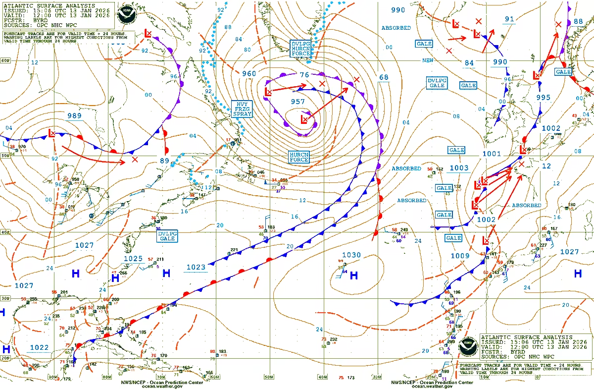


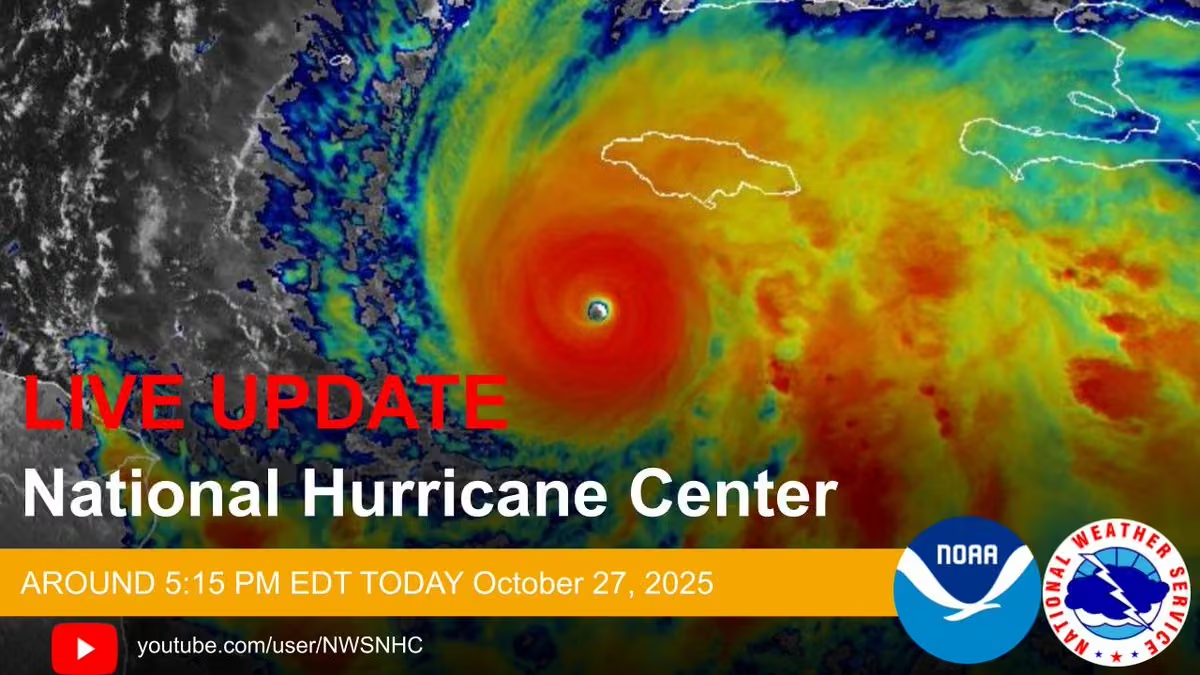


 National Weather Service

 NHC_TAFB


 NWS Juneau


 NWS Wakefield


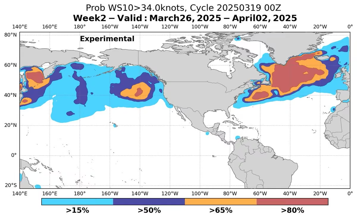


 UW-Madison CIMSS


 NWS Melbourne


 NWS Key West


 NWS Weather Prediction Center


 Seafarers Hospital Society

 UN Philippines


 NOAA Satellites


 NHC Storm Surge


 Brian McNoldy


 NWS Guam 🇬🇺
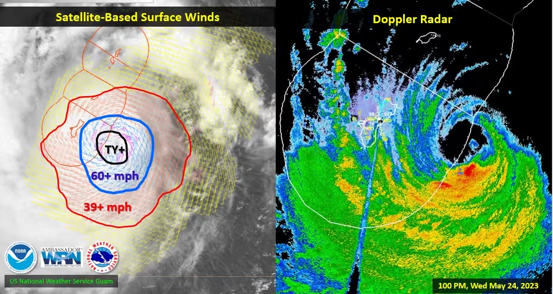


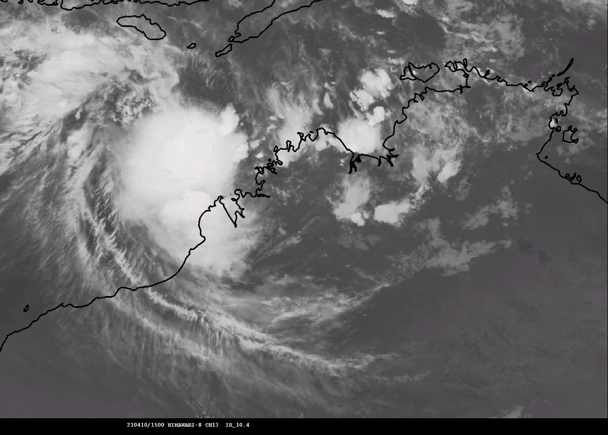
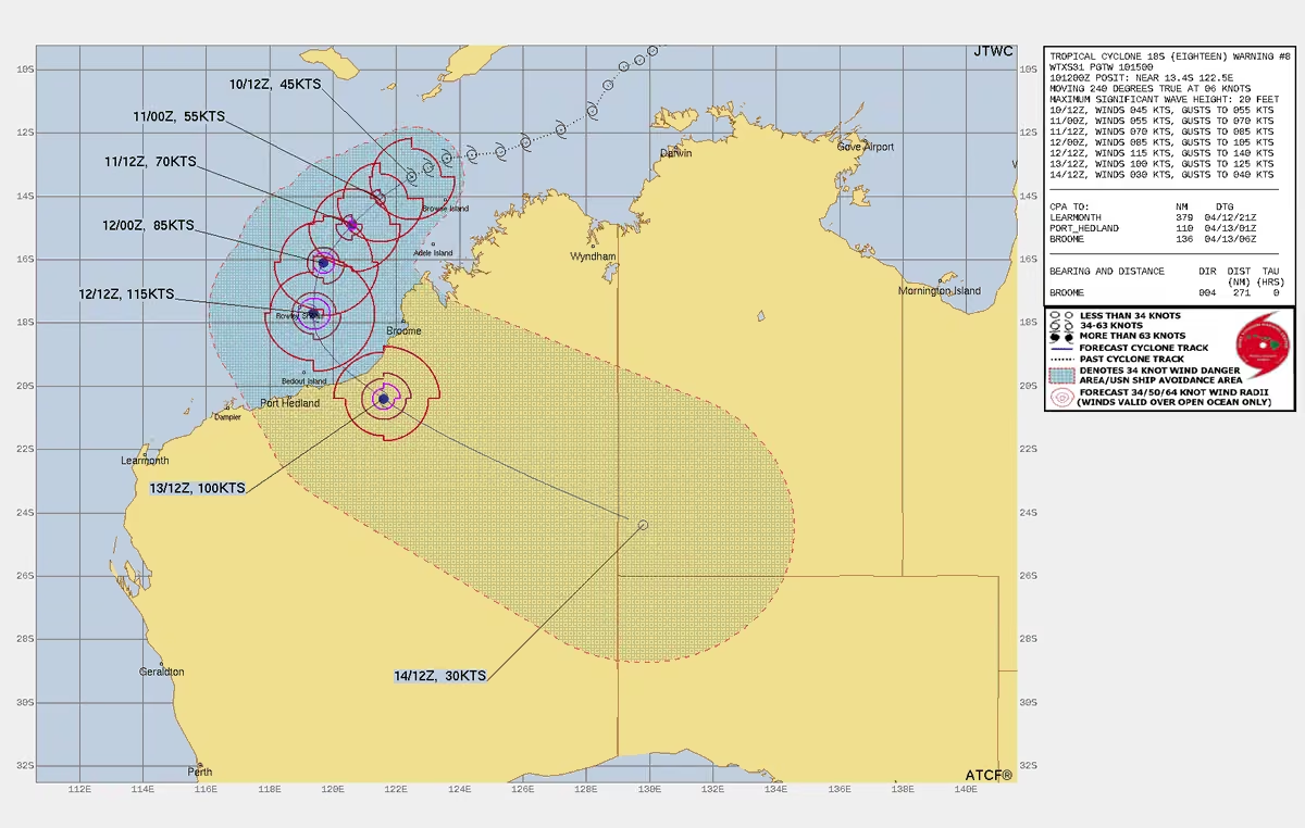


 NOAA Education


 NWS_DataBuoyCenter


 NWS Director

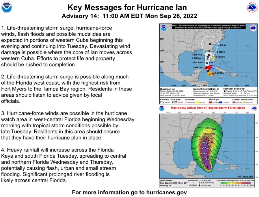
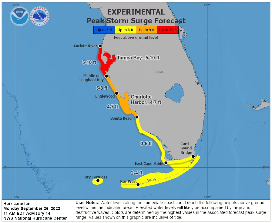
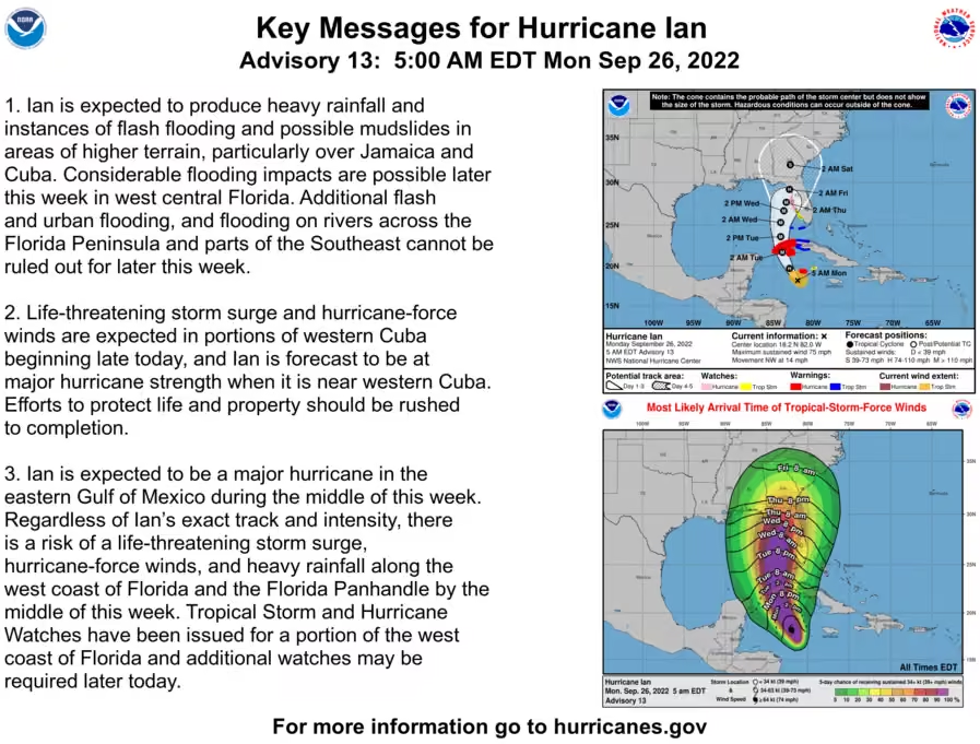


 NWS Fairbanks


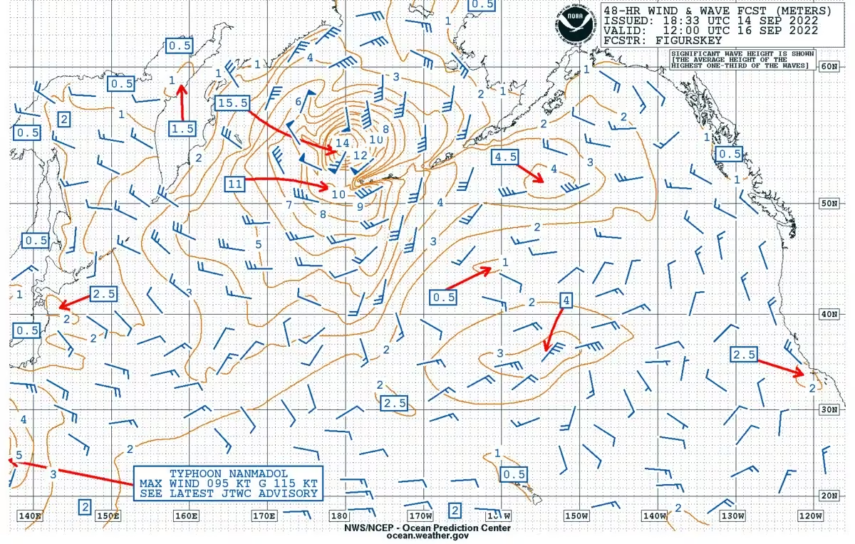


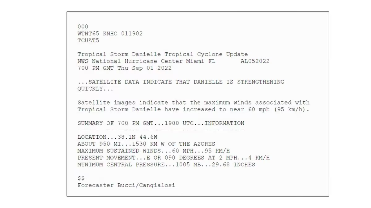


 UN Biodiversity


 NOAA WRN Ambassadors