 Vivian Gonzalez
@VivianGonzalez7

STREET FLOOD ADVISORY was extended for Northern Broward until 11:15am. @wsvn #flwx @abcmiami18 @7weather


Politicians, athletes, journalists, NGOs, companies... They all use corporation-owned social networks to communicate with us. Citizens shouldn't have to hand over their data to companies to read content published by public entities. Public Feeds changes that by making posts of popular accounts freely available. Read more.
Today In Florida Weather Anchor @WSVN
Vivian Gonzalez
@VivianGonzalez7
STREET FLOOD ADVISORY was extended for Northern Broward until 11:15am. @wsvn #flwx @abcmiami18 @7weather
Vivian Gonzalez
@VivianGonzalez7
STREET FLOOD ADVISORY for parts of MIami-Dade extended until 11:15am. @wsvn #flwx @7weather @abcmiami18
 Vivian Gonzalez
@VivianGonzalez7
STREET FLOOD ADVISORY issued for parts of Broward until 12:45pm. Davie, Cooper City, Sunrise, Weston, and Plantation now included in this advisory. @wsvn #flwx @7weather @abcmiami18
 Vivian Gonzalez
@VivianGonzalez7
STREET FLOOD ADVISORY issued for parts of Northern Miami-Dade until 10:15am. Heavy rain in Hialeah, Miami Lakes, and Palm Springs North could produce an additional 1" - 3" that could lead to flooding. @wsvn #flwx @7weather @abcmiami18
 Vivian Gonzalez
@VivianGonzalez7
STREET FLOOD ADVISORY now in effect for parts of Northern Broward until 10:15am. 1" - 2" inches of rain have fallen & an additional 1" - 3" possible. Plantation, Ft. Lauderdale, Lauderhill, Sunrise and Pompano Beach included in this advisory. #flwx @wsvn @7weather @abcmiami18
 Vivian Gonzalez
@VivianGonzalez7
It is pouring now in Miami Lakes and Palm Springs. Rainfall rates are running about 4" per hour. @wsvn #flwx @7weather @abcmiami18
 Vivian Gonzalez
@VivianGonzalez7
Rain is developing and becoming more widespread across Northern Broward. Please drive with extra caution and avoid flooded roads. @wsvn #flwx @7weather @abcmiami18
Vivian Gonzalez
@VivianGonzalez7
THU 7AM TROPICS OUTLOOK- Development chances are increasing for an area of low pressure expected near or offshore of the Southeast U.S. coast this weekend. The NHC now gives it a 60% chance of tropical or subtropical formation over the next 7 days. We'll be watching! @WSVN #flwx
 Vivian Gonzalez
@VivianGonzalez7
🌧️ INCREDIBLE RAINFALL TOTALS! Parts of South Florida have picked up over a FOOT of rain in just 48 hours! Dania Beach leads with 16.65", followed by Plantation at 16.38" and Lauderhill at 15.37". More rain today could worsen ongoing flooding! ⚠️ @WSVN #flwx @7WEATHER
 Vivian Gonzalez
@VivianGonzalez7
⚠️ FLOOD WATCH continues across South Florida through this evening! Another 1–2" of rain is possible, with isolated totals of 3–5". With the ground already saturated, additional downpours could quickly worsen flooding. Stay alert and avoid flooded roads! 🌧️ @wsvn @7weather #flwx
 Vivian Gonzalez
@VivianGonzalez7
The showers between Broward and Palm Beach have produced about 1.25" of rain in the last hour. We are monitoring the situation closely. Keep in mind it will be wet at times today and it won't take much for flooding to start. @wsvn #flwx @7weather @abcmiami18
Vivian Gonzalez reposted
Vivian Gonzalez
@VivianGonzalez7
We are monitoring a rain band moving in from the Atlantic waters. It will be bringing another prolonged period of heavy rainfall. Please stay safe and weather aware with your Storm Team. @wsvn #flwx @abcmiami18 @7weather
Vivian Gonzalez
@VivianGonzalez7
STREET FLOOD ADVISORY issued for another part of Miami-Dade until 11:45am. This includes North Miami Beach, Opa-Locka, Miami Lakes, Aventura, Miami Gardens, Hialeah, Hard Rock Stadium and Saint Thomas University. @wsvn #flwx @7weather @abcmiami18
 Vivian Gonzalez
@VivianGonzalez7
STREET FLOOD ADVISORY issued for parts of Miami-Dade until 11:15am. Downtown Miami, Coral Gables, Westchester, Miami Shores, Doral, Hialeah, UM, and Kendall will be experiencing flooding shortly due to the heavy rain. #flwx @wsvn @7weather @abcmiami18
 Vivian Gonzalez
@VivianGonzalez7
STREET FLOODING CONCERNS from the middle to lower Florida Keys. #flwx @7weather @abcmiami18 @wsvn
 Vivian Gonzalez
@VivianGonzalez7
STREET FLOOD ADVISORY now in effect for portions of the middle Florida Keys and that includes Marathon until 10:45am. #flwx @wsvn @7weather @abcmiami18
 Vivian Gonzalez
@VivianGonzalez7
WET WEDNESDAY! Be weather aware with your Storm Team! #flwx @7weather @abcmiami18 @wsvn
Vivian Gonzalez
@VivianGonzalez7
WED 7AM TROPICS OUTLOOK- NHC is watching an area near the northern Bahamas where a non-tropical low could form this weekend. Some subtropical development is possible as it moves north or northeast near the Southeast U.S. coast. Formation chances remain LOW at 20% over 7 days.
 Vivian Gonzalez
@VivianGonzalez7
NEW- STREET FLOOD WARNING now replaces the advisory for the lower Florida Keys. 2- 4" have fallen and there are reports of flooding in the area. An additional 1- 2" possible through 10:30am. @wsvn #flwx @7weather @abcmiami18
 Vivian Gonzalez
@VivianGonzalez7
STREET FLOOD ADVISORY issued for parts of the lower Florida Keys through 9:45am. Stay safe and informed! @wsvn #flwx @7weather @abcmiami18
 Vivian Gonzalez
@VivianGonzalez7
🌧️ STAGGERING RAINFALL TOTALS! South Florida has been drenched over the last 24 hours! Hollywood picked up 13.43", Davie 12.21" and Plantation 10.39"! With more heavy rain possible, flooding remains a serious concern. Please avoid flooded roads! ⚠️ @wsvn #flwx @7weather
 Vivian Gonzalez
@VivianGonzalez7
⚠️ FLOOD WATCH continues across Southeast Florida through Thursday evening! With the ground already saturated, more rounds of heavy rain could quickly trigger street flooding. Another 2–4" is possible, with much higher totals in isolated spots. Stay alert! 🌧️ @wsvn #flwx
 Vivian Gonzalez
@VivianGonzalez7
🌧️ A SOAKING WEEK AHEAD! South Florida could see 2–5" of rain, with 6"+ possible along the east coast and isolated totals of 10"+. With the ground already saturated, repeated downpours could quickly lead to street flooding. Stay weather aware with your Storm Team! ⚠️ @wsvn #flwx
 Vivian Gonzalez
@VivianGonzalez7
🌧️ STORMY TUESDAY! Rounds of showers and storms possible moving across South Florida this afternoon and continuing into tonight. Some downpours could be heavy, especially along the east coast, increasing the risk of street flooding. Stay weather aware! ⚠️ @wsvn #flwx
Vivian Gonzalez
@VivianGonzalez7
🌧️ FLOODING CONCERNS: There is an elevated risk of excessive rainfall today and Wednesday, especially along the east coast. With the ground already saturated, repeated heavy downpours could quickly lead to street flooding. Stay alert and never drive through flooded roads! ⚠️
Vivian Gonzalez
@VivianGonzalez7
🚨 FLOOD WATCH: South Florida is bracing for rounds of heavy rain through Thursday evening! 🌧️
Widespread rainfall of 2–4" is possible, with isolated areas potentially seeing 6–8"+. Repeated downpours could lead to significant street flooding, especially along the east coast.
Vivian Gonzalez
@VivianGonzalez7
🌧️ HOW MUCH RAIN? Forecast models suggest a widespread 2–4 inches across South Florida's east coast metros through Friday morning. Locally higher totals are possible, increasing the risk of urban flooding. Exact amounts and locations remain uncertain. @wsvn #flwx @7weaather
 Vivian Gonzalez
@VivianGonzalez7
⚠️ Three things to watch this week in South Florida:
🌤️ Mainly dry Monday as winds increase.
🌊 Dangerous surf and life-threatening rip currents.
☔ Heavy rain and an elevated flooding risk Tuesday through Thursday. @wsvn #flwx @7weather @abcmiami18
 Vivian Gonzalez
@VivianGonzalez7
💨 HOLD ON TO YOUR HATS! Northeast winds strengthen Monday, becoming especially gusty Tuesday with sustained winds of 20–30 mph and gusts topping 35 mph. Rough seas and dangerous beach conditions will accompany the windy weather. @wsvn #flwx
 Vivian Gonzalez
@VivianGonzalez7
☔ From dry to drenched? Rain chances jump from just 10% Monday to 50% Tuesday and 60% Wednesday and Thursday! Repeated downpours could lead to flooding, especially in areas still saturated from recent rain. @wsvn #flwx @7weather
 Vivian Gonzalez
@VivianGonzalez7
🌤️ Enjoy the quieter weather while it lasts! Monday brings a mix of sun and clouds with increasing northeast winds. A much wetter and windier pattern takes shape Tuesday, with heavy downpours and flooding possible through Thursday. @WSVN @7WEATHER #flwx

Vivian Gonzalez reposted
 Phil Ferro
@PhilFerro7
So the 7Weather team took me out for a Retirement Brunch Saturday.
I am so fortunate to work with such a wonderful group of folks.

 Vivian Gonzalez
@VivianGonzalez7
🍂 FALL FEELS ARE HERE! A strong cold front moves through South Florida today, bringing clearing skies, drier air and a cool breeze! 🌬️ Saturday will be our coolest day of the season so far with sunshine, highs in the upper 60's to low 70's and a chilly start Sunday! 🥶 #flwx
Vivian Gonzalez
@VivianGonzalez7
🏈🙌 CANES, COOL AIR & KICKOFF! It's a perfect football Saturday as Miami takes on Duke at Hard Rock Stadium! 🧡💚
☀️ Tailgate: 61°
🏈 Kickoff: 69°
🙌 Postgame: 71°
Sunshine, zero rain and plenty of #hurricanes spirit! 🙌 GO CANES! #flwx #gocanes @wsvn @abcmiami18 @7weather
 Vivian Gonzalez
@VivianGonzalez7
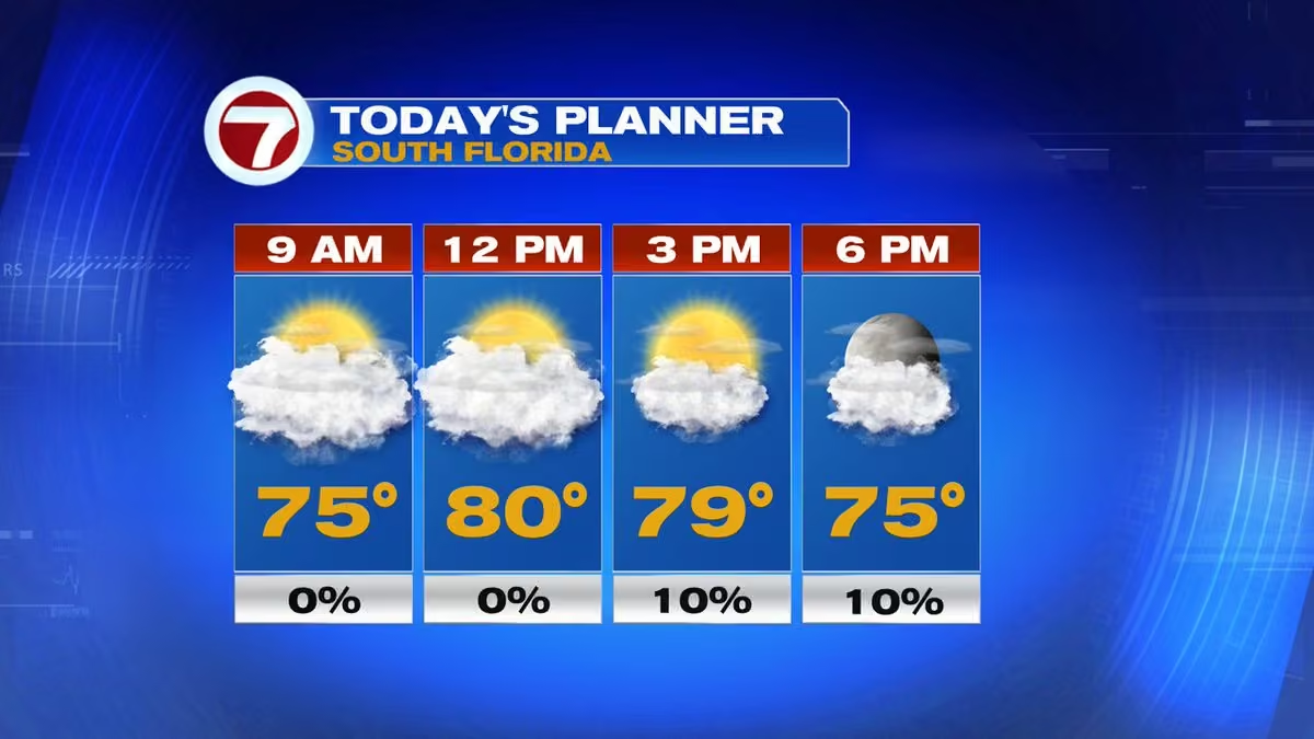
🌤️ Happy Friday, South Florida! A mix of sun and clouds this morning with temperatures climbing into the low 80's. Our cold front moves through today, bringing gradual clearing and cooler, drier air. 🍂 Rain chances stay at 10% or less. Sweater weather is almost here! 🥶 @wsvn
 Vivian Gonzalez
@VivianGonzalez7
🌤️ A dry start to Thursday across South Florida, but keep the umbrella handy! Clouds increase with scattered showers developing this afternoon. 🌧️ Rain chances climb to 40% by 3pm, with highs in the mid 80's. Cooler weather is on the way! 🍂 @wsvn @7weather #flwx
 Vivian Gonzalez
@VivianGonzalez7
🌬️ BIG CHANGES AHEAD! A strong cold front moves through South Florida early Friday, bringing clearing skies, increasing winds and a blast of cooler air! 🥶 Saturday will be our coolest day of the fall season so far, with highs only in the upper 60's to low 70's! 🍂 @wsvn #flwx
Vivian Gonzalez
@VivianGonzalez7
🍂 SWEATER WEATHER IS COMING! South Florida is about to go from mild to chilly! 🥶 Morning lows drop into the 50's Saturday and Sunday, nearly 10–15° below average! The cool snap won't last long, with temperatures warming back up early next week. Who's ready? @wsvn #flwx
 Vivian Gonzalez
@VivianGonzalez7
🥶 SWEATER WEATHER ALERT! South Florida could see its coolest temperatures of the season this weekend! Morning lows in the 50s across much of the area and Saturday highs only in the upper 60s to lower 70s. Who's ready? @wsvn #flwx @7weather @abcmiami18
Vivian Gonzalez
@VivianGonzalez7
☀️ Warm & mostly dry today across South Florida! Expect a mix of sunshine and clouds with highs in the low to mid 80's. A stray afternoon shower is possible, but most areas stay dry. Enjoy the warmth while it lasts! @wsvn #flwx @7weather @abcmiami18
 Vivian Gonzalez
@VivianGonzalez7
🥶🍂 FALL FRONT ON THE WAY! A strong cold front will sweep across the Southeast later this week, bringing a big temperature tumble! Miami stays in the 70's Thursday & Friday mornings before dropping into the upper 50's by Saturday! Sweater weather is coming! #flwx @wsvn @7weather
Vivian Gonzalez
@VivianGonzalez7
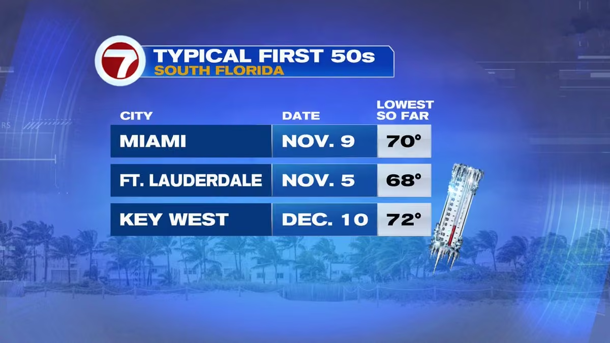
🥶🍂 The countdown to cooler weather is on! South Florida typically sees its first 50's in November, but Key West usually waits until December. Our coolest air of the season so far could arrive this weekend! @wsvn #flwx @abcmiami18 @7weather
 Vivian Gonzalez
@VivianGonzalez7
🌡️🍂 From MILD to CHILLY! South Florida starts the week with morning lows in the 70's, but a strong cold front could send temperatures tumbling into the upper 50's by the weekend. Get those sweaters ready! 🥶 @wsvn @7weather #flwx @abcmiami18
 Vivian Gonzalez
@VivianGonzalez7
🌴☀️ A beautiful start to the workweek! Expect sunshine mixed with clouds and highs in the lower to middle 80's. Rain chances remain low today, but changes are coming later this week as a strong cold front approaches South Florida! 🍂 @wsvn #flwx @7weather @abcmiami18
 Vivian Gonzalez
@VivianGonzalez7
☀️ Happy Monday, South Florida! A warm and mostly dry day ahead with a mix of sun and clouds. Temperatures climb into the lower to middle 80's with only a 10–20% chance of rain later today. @wsvn @7weather #flwx @abcmiami18
 Vivian Gonzalez
@VivianGonzalez7
🌤️ MUCH-NEEDED DRY SPELL! Rain chances drop to just 10–20% through the weekend across South Florida! Enjoy the sunshine and dry time. A few showers could return early next week, with rain chances increasing to 30–40% by Tuesday and Wednesday. #flwx @wsvn @7weather
 Vivian Gonzalez
@VivianGonzalez7
😎 WHAT A DIFFERENCE! South Florida is finally catching a break from the rain! Expect plenty of sunshine today, with temperatures climbing into the mid 80s. Rain chances stay at just 0–20%, making it a great day to get outside! #flwx @wsvn
 Vivian Gonzalez
@VivianGonzalez7
Hello Sunshine! Welcome back! #flwx @7weather @wsvn @abcmiami18
 Vivian Gonzalez
@VivianGonzalez7
THURSDAY 7AM TROPICS OUTLOOK: The NHC continues monitoring a non-tropical low south of Bermuda that could acquire subtropical characteristics through the weekend. Development chances remain at 30% through 48 hours and 50% through 7 days. #flwx
 Vivian Gonzalez
@VivianGonzalez7
STREET FLOOD ADVISORY issued now for Central Miami-Dade until 12pm. #flwx @wsvn @7weather @abcmiami18
 Vivian Gonzalez
@VivianGonzalez7
STREET FLOOD ADVISORY issued for parts of Miami-Dade until 10:45am. Flooding is ongoing and an additional 2 inches of rain possible. Sweetwater, Kendale Lakes, Westchester, and FIU South Campus included in advisory. Avoid flooded streets. #flwx @wsvn @7weather
 Vivian Gonzalez
@VivianGonzalez7
Please avoid driving through flooded streets and walking through standing water. The water could be contaminated and there could be sharp debris. Stay weather aware with your Storm Team! #flwx @wsvn @7weather @abcmiami18
 Vivian Gonzalez
@VivianGonzalez7
WEDNESDAY 7AM TROPICS OUTLOOK- Development chances are increasing for an area of low pressure south of Bermuda. The system could gradually acquire subtropical characteristics through the weekend.
Formation chances: 30% through 48 hours and 50% through 7 days. #flwx @7weather
 Vivian Gonzalez
@VivianGonzalez7
Additional totals in the last 12 hours adding to the flooding issues in Broward.
 Vivian Gonzalez
@VivianGonzalez7
FLOOD ADVISORY for southern Broward until 10:30am! Heavy storms have already dropped 1–2" of rain, with another 1–2" possible. Minor flooding is ongoing in areas including Pembroke Pines, Miramar, Davie, Weston and Sunrise. Avoid flooded roads! #flwx @wsvn @7weather @abcmiami18
 Vivian Gonzalez
@VivianGonzalez7
STORMS PACKING A PUNCH! Radar shows heavy downpours and frequent lightning over the last 3 hours across parts of Broward and northern Miami-Dade, including Davie, Pembroke Pines and Miami Lakes. ⚠️ More rain could worsen flooding in already saturated areas. @wsvn #flwx @7weather
Vivian Gonzalez
@VivianGonzalez7
🌦️ SLOWLY TURNING THE CORNER! South Florida can expect more showers and storms this morning, with heavy downpours possibly adding to flooding concerns. Rain should gradually decrease this afternoon, bringing more dry time. Much better weather is on the way! ☀️ #flwx @wsvn
Vivian Gonzalez
@VivianGonzalez7
Showers and storms impacting your morning drive right now between Broward and Miami-Dade. #flwx @7weather @wsvn @abcmiami18
Vivian Gonzalez
@VivianGonzalez7
We've seen some in and out showers and thunderstorms. This will be the pattern throughout today. Make sure to have the rain gear with you. @wsvn #flwx
Vivian Gonzalez
@VivianGonzalez7
COASTAL FLOODING ALERT! A Coastal Flood Advisory remains in effect until 7pm tonight for coastal Miami-Dade, Broward and Palm Beach counties. Higher-than-normal tides and onshore winds could cause flooding in low-lying areas, especially around high tide. ⚠️ #flwx @wsvn
 Vivian Gonzalez
@VivianGonzalez7
⚠️ FLOODING ALERT! Multiple flood advisories and warnings remain in effect along Florida's East Coast, especially near Fort Pierce and the Treasure Coast. Heavy rainfall has led to significant flooding concerns. Avoid flooded roads and use caution when traveling! 🌧️ #flwx @wsvn
 Vivian Gonzalez
@VivianGonzalez7
🗳️🌧️ ELECTION DAY FORECAST! Keep the umbrellas handy as you head to the polls! Showers and storms remain possible throughout the day, with heavy downpours and flooding concerns. The good news? Gradual improvement starts midweek! @wsvn #flwx @abcmiami18
 Vivian Gonzalez
@VivianGonzalez7
🌧️ INCREDIBLE RAIN TOTALS! The last 72 hours have brought impressive rainfall across parts of South Florida! Nearly 30 inches in Okeechobee, over 28 inches in Port St. Lucie and more than 18 inches in Sunrise! ⚠️ More rain today could worsen flooding in saturated areas. #flwx
 Vivian Gonzalez
@VivianGonzalez7
🌧️ STAGGERING RAIN TOTALS! Parts of South Florida have been drenched over the last 72 hours! Sunrise recorded 18.74", Davie 10.29" and Coral Springs 8.89". More rain today could worsen flooding in already saturated neighborhoods. ⚠️ #flwx
 Vivian Gonzalez
@VivianGonzalez7
TUE 7AM TROPICS OUTLOOK- NHC is monitoring an area south of Bermuda where low pressure could develop subtropical characteristics late this week.
Development chances remain LOW: 10% through 48 hours and 30% through 7 days.
No immediate threat to South Florida. @WSVN @7WEATHER
 Vivian Gonzalez
@VivianGonzalez7
STREET FLOOD ADVISORY in effect through 12:30pm for another portion of the lower Florida Keys. Includes mile markers 13 & 21. Sugarloaf Key, Upper Sugarloaf, Bay Point, Saddlebunch Keys & Cudjoe Key dealing with ongoing flooding. Additional 1-3" possible. @wsvn #flwx @7weather
Vivian Gonzalez
@VivianGonzalez7
Rain so far in the last 24 hours. @wsvn #flwx @7weather @abcmiami18
 Vivian Gonzalez
@VivianGonzalez7
STREET FLOOD ADVISORY issued for parts of lower Florida Keys. Key West, Fleming Key, and Sunset Key could experience flooding soon. 1 to 3 inched possible for these areas with the heavy rain around. Avoid driving through flooded roads. @wsvn #flwx
 Vivian Gonzalez
@VivianGonzalez7
🌧️ ANOTHER SOGGY DAY! Keep the umbrella handy, South Florida! Showers and storms are expected throughout today, with rain chances of 70–80%. Heavy downpours could lead to additional flooding. 🌂 Highs stay in the upper 70's to near 80 degrees. @wsvn #flwx @7weather @abcmiami18
 Vivian Gonzalez
@VivianGonzalez7
MON 7AM TROPICS OUTLOOK- A non-tropical low near Bermuda could gradually gain tropical characteristics later this week. Development chances remain LOW at 20% over the next 7 days and 0% over the next 2 days. No immediate threat to South Florida. @7WEATHER @WSVN @ABCMIAMI18
 Vivian Gonzalez
@VivianGonzalez7
🌊 COASTAL FLOOD ADVISORY continues for the Florida Keys through 5am Tuesday! Minor coastal flooding is possible around high tide, especially in low-lying areas. Watch for water-covered roads and avoid driving through floodwaters! ⚠️ @wsvn #flwx
 Vivian Gonzalez
@VivianGonzalez7
🌊 COASTAL FLOODING CONCERNS CONTINUE! A Coastal Flood Advisory remains in effect through 7pmTuesday for coastal Miami-Dade and Broward. Minor to moderate flooding is possible around high tide, especially in low-lying areas. Avoid driving through flooded roads! ⚠️ @wsvn #flwx
 Vivian Gonzalez
@VivianGonzalez7
🌊 DANGEROUS SURF! A High Surf Advisory remains in effect for Broward County beaches until 7am this morning. Strong waves and a high risk of rip currents make swimming dangerous. Stay out of the rough surf and follow lifeguard warnings! ⚠️ #flwx @wsvn @7weather
 Vivian Gonzalez
@VivianGonzalez7
⚠️ FLOOD WATCH continues through tonight for much of South Florida! Additional rainfall of 1–3 inches is possible, with isolated areas seeing 4 inches or more. 🌧️ Repeated heavy downpours could lead to street flooding, especially in already saturated areas. @WSVN #flwx
 Vivian Gonzalez
@VivianGonzalez7
Build A Better World exhibit grand opening @MODSFTL with Chief @PhilFerro7!
Stop by and experience what we do as meteorologists and learn about storm safety and preparedness.
@wsvn @ABCMiami18 @7Weather
 Vivian Gonzalez
@VivianGonzalez7
🌊 HIGH TIDE ALERT! Another round of King Tides is expected this afternoon. High tides range from 12:15pm in Fort Lauderdale to 2:38pm in Key West. Coastal flooding remains possible, especially in low-lying neighborhoods. Watch for flooded roads! @wsvn #flwx @7weather
 Vivian Gonzalez
@VivianGonzalez7
🎃 SPOOKY SHOWERS are heading our way! Halloween Saturday turns breezier and wetter, with rounds of rain possible. 🌧️ Sunday into Monday brings the greatest risk of heavy rain and flooding. Keep the umbrella handy for weekend plans! @wsvn #flwx @7weather @abcmiami18
 Vivian Gonzalez
@VivianGonzalez7
⚠️ KING TIDES AREN'T DONE YET! A Coastal Flood Advisory continues through 8pm Saturday for coastal Miami-Dade and Broward. Minor to moderate flooding remains possible around high tide. Avoid driving through flooded streets! 🌊 @wsvn #flwx
 Vivian Gonzalez
@VivianGonzalez7
🌊 COASTAL FLOOD ALERT! A Coastal Flood Warning remains in effect through 11pm Friday for portions of the Florida Keys. King Tides continue to bring flooding concerns, especially around high tide. Watch for water-covered roads in low-lying coastal areas! ⚠️ @WSVN #flwx
 Vivian Gonzalez
@VivianGonzalez7
🌊 TIDAL TROUBLES continue across South Florida! Major coastal flooding is possible again today, especially around high tide.
💨 The good news? Winds are finally easing, with fewer showers to end the workweek.
🎃 Halloween stays warm and humid with a chance of spooky showers!
 Vivian Gonzalez
@VivianGonzalez7
🌊 HISTORIC KING TIDES! Water levels at Virginia Key have reached 2.54 feet, ranking THIRD highest since 1994, behind Hurricane Irma in 2017 and Wilma in 2005.
A reminder that coastal flooding can be significant even without a hurricane! @wsvn #flwx @7weather
 Vivian Gonzalez
@VivianGonzalez7
⚠️ COASTAL FLOOD ALERT! Another round of King Tides is expected late this morning, with high tides between 10:27am and 12:45pm across our coastal communities.
🌊 Flooded streets are possible, especially in low-lying areas. Avoid driving through floodwaters! @wsvn #flwx
 Vivian Gonzalez
@VivianGonzalez7
Minor flooding starting for Key Largo. @wsvn #flwx @7weather
 Vivian Gonzalez
@VivianGonzalez7
Moderate flooding being reported in Port Everglades and Virginia Key. @wsvn #flwx @7weather
 Vivian Gonzalez
@VivianGonzalez7
Here is what a Wind Advisory means: #flwx @wsvn @7weather @abcmiami18
 Vivian Gonzalez
@VivianGonzalez7
WIND RELIEF IS COMING! Another windy Tuesday with gusts of 25–35mph, but winds gradually ease Wednesday to 15–25mph. By Thursday, speeds drop to 10–15mph. A much calmer end to the week is ahead! @wsvn @7weather #flwx @abcmiami18
 Vivian Gonzalez
@VivianGonzalez7
KING TIDE ALERT! Another round of unusually high tides this morning, with water levels running about 3 feet above average. Peak high tides occur between 9:30–10:45am along much of our East Coast. Coastal flooding remains a major concern! @wsvn #flwx #kingtides #flooding
 Vivian Gonzalez
@VivianGonzalez7
⚠️ WIND ADVISORY remains in effect for Miami-Dade and Broward through 8pm today! Northeast winds of 15–25mph could gust up to 40mph. Watch for blowing debris, secure outdoor furniture and be extra careful on bridges and elevated roadways. @wsvn @7weather #flwx
 Vivian Gonzalez
@VivianGonzalez7
HOLD ON TO YOUR HATS! Another windy day across South Florida! Northeast winds could gust between 35–40 mph this afternoon, especially along the East Coast. Secure loose outdoor items and use caution while driving. @wsvn #flwx @7weather
 Vivian Gonzalez
@VivianGonzalez7
Peak wind gusts this morning so far... #flwx @wsvn @abcmiami18
 Vivian Gonzalez
@VivianGonzalez7
Flooding reports from King Tides this morning. @wsvn @abcmiami18 #flwx @7weather #kingtides #flooding
 Vivian Gonzalez
@VivianGonzalez7
Outside our North Bay Village studio!
# kingtide #flooding #windy @NWSMiami @wsvn @ABCMiami18 #flwx
Vivian Gonzalez
@VivianGonzalez7
High tide underway... We have peak King Tides and now add strong northeast winds pushing even more water toward the coast. There's nowhere for that extra water to go, and that's why we're seeing more significant coastal flooding, even without heavy rainfall. #flwx @wsvn
Vivian Gonzalez
@VivianGonzalez7
KING TIDES UPDATE: Water levels have reached moderate coastal flood stage at Virginia Key (1.73 ft) and Port Everglades (2.08 ft). Strong onshore winds and high tides continue to raise flooding concerns across South Florida. Avoid flooded streets! ⚠️ @wsvn #flwx @abcmiami18
 Vivian Gonzalez
@VivianGonzalez7
🌊 COASTAL FLOOD WARNING remains in effect for Miami-Dade and Broward through 8pm Wednesday! Major flooding is possible around high tide as King Tides combine with strong onshore winds. Low-lying streets and properties could flood. Avoid driving through standing water! #flwx
 Vivian Gonzalez
@VivianGonzalez7
🌊 DANGEROUS SEAS! A Gale Warning remains in effect for South Florida's Atlantic waters through Wednesday morning. Winds of 30–35 mph, gusting to 40 mph, with seas building 9–14 feet. Boating conditions are hazardous. Stay safe on the water! ⚠️ @wsvn #flwx @7weather @abcmiami18
Vivian Gonzalez
@VivianGonzalez7
💨 HOLD ON TO YOUR HATS! A Wind Advisory is in effect for Miami-Dade and Broward from 11am through Tuesday evening. Northeast winds of 20–25mph could gust up to 40mph! Secure loose outdoor items and watch for falling branches. @wsvn #flwx @7weather @abcmiami18
 Vivian Gonzalez
@VivianGonzalez7
⚠️ MULTIPLE WEATHER ALERTS across South Florida! Strong winds, King Tides and dangerous beach conditions continue. Coastal Flood Warnings are in effect for Miami-Dade, Broward and the Upper Keys. Gale Warnings and a high rip current risk also remain. Avoid flooded roads! @wsvn
 Vivian Gonzalez
@VivianGonzalez7
🌊 KING TIDE ALERT! Coastal flooding is a major concern across South Florida this morning! High tides peak between 8:46 and 9:11am along much of our Atlantic coast, and at 11:05am in Key West. Strong onshore winds could worsen flooding. Avoid flooded roads! @wsvn #flwx
 Vivian Gonzalez
@VivianGonzalez7
🌊 COASTAL FLOODING: What's the difference between an Advisory and a Warning?
⚠️ ADVISORY: Minor or nuisance flooding expected.
🚨 WARNING: Significant flooding is imminent or already occurring.
With King Tides peaking this weekend, know the difference and stay alert! #flwx
 Vivian Gonzalez
@VivianGonzalez7
🚨 COASTAL FLOOD WARNING UPGRADE! The Upper Keys are now under a Coastal Flood Warning for MAJOR saltwater flooding during high tides through Saturday morning. Numerous roads could close, with flooding possible in homes and businesses. Avoid flooded roads! @wsvn @7weather #flwx
 Vivian Gonzalez
@VivianGonzalez7
WEEKEND RAIN UPDATE: Rainfall amounts have come down! Most of South Florida could see less than 2 inches through Sunday, with 2–3 inches possible near Palm Beach County. Heavier rain may stay offshore, but localized flooding remains possible. @wsvn #flwx @7weather
 Vivian Gonzalez
@VivianGonzalez7
⚠️ FLOOD CONCERNS: South Florida faces a combination of peak King Tides, strong onshore winds and possible heavy rain this weekend. Coastal flooding could be significant, especially Sunday into Monday. Low-lying neighborhoods should prepare for rising water. @wsvn @7weather #flwx
 Vivian Gonzalez
@VivianGonzalez7
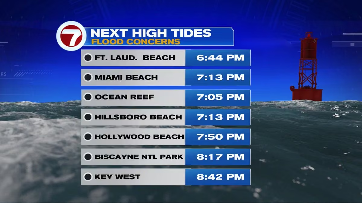
KING TIDE ALERT! Coastal flooding is a concern again this evening as high tides return between 6:44pm and 8:42pm across South Florida and the Keys. Strong onshore winds could push water into low-lying streets. Use caution and avoid flooded roads! @wsvn @7weather #flwx
 Vivian Gonzalez
@VivianGonzalez7
THU 8AM TROPICS OUTLOOK- Another disturbance east-southeast of Bermuda has a low 10% chance of development over the next 7 days. @wsvn @7weather
 Vivian Gonzalez
@VivianGonzalez7
🌤️ A nice start to Thursday across South Florida! Temperatures climb from the low 70's this morning into the low 80's this afternoon. Expect a mix of sun and clouds, breezy conditions and a few passing showers later today. 🌴 @wsvn @7weather #flwx @abcmiami18
 Vivian Gonzalez
@VivianGonzalez7
THU 5AM ADIVSORY- Subtropical Storm #josephine has winds of 65mph & is moving northeast away from the U.S. It is forecast to become a powerful post-tropical system with hurricane-force winds. Dangerous surf and rip currents continue along the East Coast. @wsvn @7weather
 Vivian Gonzalez
@VivianGonzalez7
⚠️ A soggy weekend ahead for South Florida! Saturday brings a risk of heavy rain, with 3–5 inches possible and locally higher amounts. 🌧️ Wind gusts up to 40 mph and King Tides could worsen street flooding. More rain is expected Sunday. Stay weather aware! #flwx
 Vivian Gonzalez
@VivianGonzalez7
A nice stretch of weather ahead for South Florida today! We're starting in the upper 60's and low 70's, warming into the mid 80's this afternoon. Expect plenty of sunshine, a few clouds and just a 10% chance of a passing shower later today. Enjoy! @wsvn #flwx @abcmiami18
 Vivian Gonzalez
@VivianGonzalez7
WEDNESDAY 8AM TROPICS OUTLOOK- NHC continues to monitor Invest 93L, a powerful non-tropical low off the Mid-Atlantic coast. It has a 40% chance of subtropical development. Regardless of formation, strong winds, coastal flooding and dangerous surf remain concerns. @wsvn @7weather
 Vivian Gonzalez
@VivianGonzalez7
TUE 8AM TROPICS OUTLOOK: NHC is monitoring a non-tropical low off the North Carolina coast (Invest 93L). It now has a 40% chance of briefly becoming subtropical over the next 2–7 days. The system is expected to move northeast away from the U.S. later this week. @wsvn @7weather
 Vivian Gonzalez
@VivianGonzalez7
Dangerous surf continues along our Atlantic beaches! A High Surf Advisory remains in effect for Broward through 8pm today, with breaking waves up to 6–8 feet. ⚠️ A high rip current risk also continues through Thursday. Stay out of the rough surf! @wsvn @7weather #flwx
 Vivian Gonzalez
@VivianGonzalez7
Good morning, South Florida! A breezy Tuesday ahead with a mix of sunshine, clouds and a few passing showers. 🌦️ Temperatures climb from the upper 70's this morning to the mid 80's this afternoon. Plenty of dry time, but keep an eye out for a quick shower! @wsvn @7weather #flwx
 Vivian Gonzalez
@VivianGonzalez7
Hold onto your hats, South Florida! Northeast winds of 15–25 mph today could gust over 30 mph. Winds ease a little Wednesday before picking up again Thursday. 🌴 Another round of even stronger winds is possible this weekend! @wsvn #flwx @7weather @abcmiami18
 Vivian Gonzalez
@VivianGonzalez7
💗 What an incredible morning at Making Strides Broward! 🎀 More than 20,000 people came together to celebrate survivors, honor loved ones, and support the fight against breast cancer! So inspiring to see our South Florida community united! 💕 #makingstrides @wsvn @ABCMiami18


 Vivian Gonzalez
@VivianGonzalez7
Rare visit with the Night Team. Always great working with @cstevenson7 and @belkysnerey!
@wsvn @ABCMiami18
 Vivian Gonzalez
@VivianGonzalez7
A few downpours have developed in Miami-Dade. @wsvn @7weather @abcmiami18 #flwx
Vivian Gonzalez
@VivianGonzalez7
Isolated storm has developed in northeastern Broward. Heavy rain and lightning in the area. @wsvn @7weather #flwx @abcmiami18
Vivian Gonzalez
@VivianGonzalez7
Walking for a cause this Saturday! I'll be at Amerant Bank Arena for Making Strides Against Breast Cancer! The morning looks warm and mainly dry, with temperatures in the upper 70's to near 80. Rain chances increase later in the day. Hope to see you there! @wsvn #flwx @abcmiami18
 Vivian Gonzalez
@VivianGonzalez7
🌧️ South Florida, get ready for a wet weekend! Rain chances jump to 80% Saturday and 70% Sunday as a front moves through. ☔ The good news? Rain chances drop next week, but windy conditions will take over! 💨 @wsvn #flwx @abcmiami18 @7weather
 Vivian Gonzalez
@VivianGonzalez7
🏈☔ Heading to the FSU vs. UM game Saturday night? Pack the poncho! Showers and storms could impact your tailgating plans and the 7pm kickoff. 🌧️ Rain chances are 80% at 4pm, 70% at kickoff and 50% by 10pm. @wsvn #flwx @abcmiami18 @7weather
 Vivian Gonzalez
@VivianGonzalez7
⚠️ HEAVY RAIN ALERT! Saturday's biggest concern is between 2–8pm along South Florida's East Coast. 🌧️ Rainfall totals of 1–3 inches are possible, with isolated spots seeing up to 6 inches. Localized flooding is a concern, especially in Broward and Palm Beach. @wsvn #flwx
 Vivian Gonzalez
@VivianGonzalez7
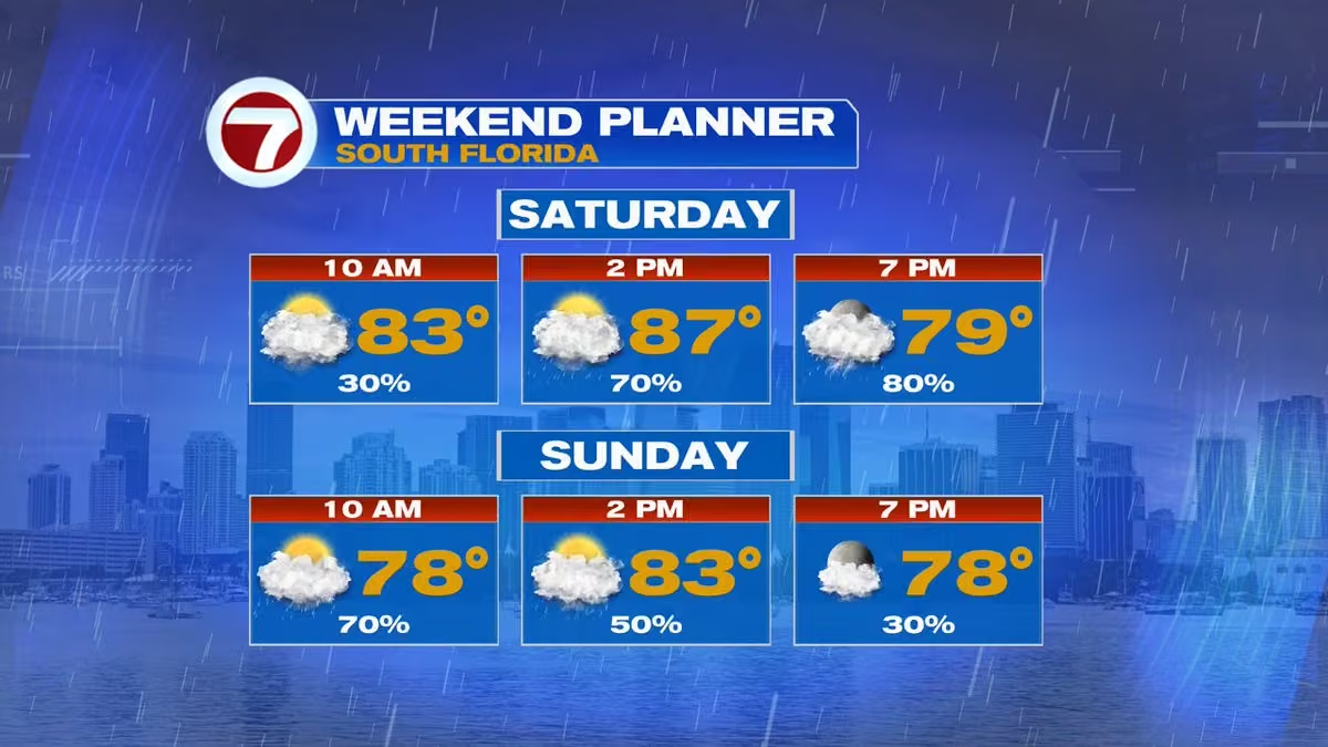
☔ Weekend plans? Saturday starts with a few showers, but rain chances climb to 70–80% by the afternoon and evening. 🌧️ Sunday starts soggy before rain gradually tapers off. Then get ready for stronger winds and rough seas heading into next week! @wsvn @7weather #flwx @abcmiami18
 Vivian Gonzalez
@VivianGonzalez7
💨 Windy weather is on the way, South Florida! Winds will shift out of the north/northeast and strengthen this weekend as a front approaches. 🌊 Expect gusty conditions and increasingly rough seas, with strong easterly winds continuing into early next week. @wsvn #flwx @7weather
 Vivian Gonzalez
@VivianGonzalez7
🌧️ South Florida, keep those umbrellas handy! Rain chances increase Friday, with Saturday shaping up to be the wettest day as a front approaches. ☔ Heavy downpours and localized flooding are possible. Rain may ease Sunday, but stronger winds are on the way! @wsvn #flwx
 Vivian Gonzalez
@VivianGonzalez7
🌤️ Happy Thursday, South Florida! Expect a warm and muggy day with highs near 90 and feels-like temperatures of 100–105! 🥵 A few showers are possible late morning into midday, with more storms developing inland and across SW Florida this afternoon. @wsvn @7weather #flwx
 Vivian Gonzalez
@VivianGonzalez7
South Florida, enjoy the drier weather while it lasts! Rain chances climb from 30% today to 50% Friday, then jump to 70–80% this weekend into early next week. ☔ A nearby front could bring periods of heavy rain and gusty winds. Stay tuned! @wsvn @7weather #flwx @abcmiami18
 Vivian Gonzalez
@VivianGonzalez7
🌤️ Happy Wednesday, South Florida! A mix of sun and clouds to start, with a few passing showers possible around lunchtime and this afternoon. 🌦️ Highs climb into the upper 80's as humidity slowly makes a comeback. @wsvn @7weather #flwx @abcmiami18
 Vivian Gonzalez
@VivianGonzalez7
Few showers possible around the Upper Florida Keys. @wsvn @7weather #flwx @abcmiami18
Vivian Gonzalez
@VivianGonzalez7
What a sweet surprise! A special delivery of Knaus Berry Farm cinnamon rolls from Steven and the 7 Drone Force crew, plus a visit from the adorable Journey! 🐶 Thanks for making our morning a little sweeter!🍥
@knausberryfarm @wsvn @7Weather @ABCMiami18
 Vivian Gonzalez
@VivianGonzalez7
Happy Tuesday, South Florida! We're enjoying a welcome break from the humidity today! Expect plenty of sunshine, breezy northeast winds and highs in the upper 80's. Enjoy it! @wsvn @7weather #flwx @abcmiami18
 Vivian Gonzalez
@VivianGonzalez7
🍂 A little taste of fall in South Florida! No big temperature drop, but the lower humidity is making a difference today. Breezy northeast winds, sunshine and mainly dry conditions make for a pretty nice Tuesday! @wsvn @7weather #flwx @abcmiami18
 Vivian Gonzalez
@VivianGonzalez7
🚀🪼 A jellyfish in the South Florida sky! We caught this incredible jellyfish-like cloud from this morning's SpaceX launch. The glowing rocket plume spread across the sky just before sunrise, creating quite the show! Did you catch it too? 🌅 #spacex @wsvn @7weather #flwx
 Vivian Gonzalez
@VivianGonzalez7
🌤️ Enjoy the drier weather while it lasts, South Florida! Rain chances drop to just 10% Tuesday before gradually climbing through the week. By the weekend, we're looking at a wetter pattern with rain chances reaching 60% Saturday and 70% Sunday. ☔ @wsvn #flwx @abcmiami18
 Vivian Gonzalez
@VivianGonzalez7
☀️ Tuesday is shaping up to be the nicest day of the week! Plenty of sunshine, very little rain and noticeably lower humidity. Still warm with highs in the upper 80's, but a refreshing change after all that tropical moisture! @wsvn @7weather #flwx @abcmiami18
 Vivian Gonzalez
@VivianGonzalez7
🌤️ A small taste of fall is on the way, South Florida! A weak front moves through today, bringing a mix of sun and clouds with a few afternoon showers. Skies clear tonight as drier air moves in, setting us up for a less humid Tuesday! 🍂 @wsvn @7weather #flwx @abcmiami18
Vivian Gonzalez
@VivianGonzalez7
Rain and gusty winds have made it along the Florida Panhandle. #isaias @wsvn @7weather #flwx @abcmiami18
Vivian Gonzalez
@VivianGonzalez7
FRIDAY 11AM ADVISORY- The center of #isaias is expected to reach the western Florida Panhandle coast this evening. Life-threatening storm surge and devastating winds likely along the Florida Panhandle and Alabama coasts. @wsvn #flwx @abcmiami18
 Vivian Gonzalez
@VivianGonzalez7
Isaias strengthens into a Category 3 hurricane on path towards U. S. Gulf coast. #tropics @wsvn @7Weather @ABCMiami18 #isaias
Vivian Gonzalez
@VivianGonzalez7
LIFE-THREATENING STORM SURGE: Hurricane #isaias could bring 6–9 feet of storm surge to portions of the Florida Panhandle, with 4–7 feet possible along other coastal areas. Dangerous coastal flooding is expected as Isaias approaches landfall tonight. @wsvn #flwx
 Vivian Gonzalez
@VivianGonzalez7
As Hurricane #isaias moves inland, the risk for tornadoes will increase across the Florida Panhandle, southern Georgia and parts of the Carolinas. The greatest threat is in the storm's eastern side, where tornadoes can develop quickly. @wsvn #flwx
 Vivian Gonzalez
@VivianGonzalez7
Hurricane #isaias could bring 4–8 inches of rain to parts of the Gulf Coast and Southeast over the next 48 hours, with isolated totals near 15 inches! The heaviest rain is forecast near and east of its track, raising concerns for flash flooding. @wsvn #flwx
 Vivian Gonzalez
@VivianGonzalez7
Buoy data showing that Tropical-storm-force wind gusts reaching the northern Gulf coast. @wsvn @7weather #flwx @abcmiami18
 Vivian Gonzalez
@VivianGonzalez7
ISAIAS TRACK: The latest forecast cone brings #isaias toward the Alabama–Florida Panhandle coast, near the Pensacola area, tonight into early Saturday. The center could cross the coast around 2am Saturday, but dangerous winds and storm surge will arrive well before landfall.
 Vivian Gonzalez
@VivianGonzalez7
BREAKING: ISAIAS IS NOW A MAJOR HURRICANE! Hurricane Hunters confirm Category 3 strength with sustained winds of 120mph. Located 240 miles south of Pensacola, FL, Isaias is moving NNE at 15 mph toward the northern Gulf Coast. Dangerous conditions expected ahead of landfall. #flwx
Vivian Gonzalez
@VivianGonzalez7
Hurricane #isaias has a growing wind field as it approaches the northern Gulf Coast. Tropical-storm-force winds extend up to 185 miles from the center, while hurricane-force winds reach 30 miles out. Conditions will deteriorate today, well ahead of landfall tonight. #flwx
 Vivian Gonzalez
@VivianGonzalez7
FRI 8AM ADVISORY- Hurricane #isaias is on the verge of CAT 3 strength with 110 mph winds & pressure down to 958mb. Landfall expected along the northern Gulf Coast tonight. Life-threatening storm surge could reach 6–9 feet in parts of the FL Panhandle. Finish preparations NOW!
Vivian Gonzalez
@VivianGonzalez7
Happy Friday, South Florida! A warm and breezy day ahead with a mix of sun and clouds. Temperatures climb from the mid 80's this morning to near 90 this afternoon. Rain chances stay low along the coast, with a few showers or storms possible later today. @wsvn @7weather #flwx
 Vivian Gonzalez
@VivianGonzalez7
Isolated storm moving through middle Florida Keys. @wsvn #flwx @7weather @abcmiami18
Vivian Gonzalez
@VivianGonzalez7
FRIDAY 5AM CONE- #isaias is forecast to reach Category 3 strength with 120mph winds this afternoon before weakening slightly. Landfall expected along the northern Gulf Coast tonight into early Saturday. Heavy rain and flooding threats will spread inland through the weekend. #flwx
 Vivian Gonzalez
@VivianGonzalez7
FRIDAY 5AM ADVISORY- Hurricane #isaias strengthens to 110mph, just shy of Category 3! Now moving NNE at 15mph and expected to make landfall along the northern Gulf Coast tonight or early Saturday. Life-threatening storm surge possible. Preparations should be completed today!
Vivian Gonzalez
@VivianGonzalez7
FRIDAY 2AM ADVISORY- Both NOAA and Air Force Hurricane Hunters flying inside Hurricane #isaias. Storm Surge and Hurricane Warnings remain in effect for parts of the Northern Gulf coast. @wsvn @7weather #flwx @abcmiami18
Vivian Gonzalez reposted
Phil Ferro
@PhilFerro7
The eye of #isaias has become Visible, the first of the 2026 Season. Satellite and recon center fixes indicate that the hurricane appears to have made its expected turn toward the northeast. It'll now aim for the Gulf States.
Vivian Gonzalez reposted
Phil Ferro
@PhilFerro7
5 pm Thursday Hurricane #isaias update: It is stronger now at category 2 strength. Still forecast to impact the area between the westernmost Panhandle & Mobile Alabama to the west. Impacts will be felt far and wide outside the cone.

 Vivian Gonzalez
@VivianGonzalez7
Here are the Storm Surge Watches and Warnings with the changes as of 11am. @wsvn @7weather #flwx @abcmiami18
 Vivian Gonzalez
@VivianGonzalez7
THURSDAY 11AM ADVISORY- Hurricane #isaias is stronger. Winds are up to 85mph. A Storm Surge warning has been issued from the Steinhatchee River eastward to the Suwanee River, Florida. @wsvn @7weather @abcmiami18 #flwx
Vivian Gonzalez
@VivianGonzalez7
Scattered showers and storms will develop, especially this afternoon. Slow-moving downpours could produce some areas of street flooding. Highs in the upper 80's to around 90 degrees. #flwx @wsvn @7weather @abcmiami18
Vivian Gonzalez
@VivianGonzalez7
Hurricane Hunters currently investigating #isaias. New data showing the pressure is dropping and that could be a sign it is strengthening. @wsvn @7weather #flwx @abcmiami18
Vivian Gonzalez
@VivianGonzalez7
THURSDAY 8AM ADVISORY & CONE- Hurricane #isaias maintains 80mph winds, but its pressure has dropped to 975mb. Further strengthening is expected before landfall along the northern Gulf Coast late Friday or early Saturday. Life-threatening storm surge of 5–7 feet is possible. @WSVN
 Vivian Gonzalez
@VivianGonzalez7
THURSDAY 5AM CONE- Hurricane #isaias continues to strengthen in the Gulf, with winds forecast to reach 110mph early Friday. The latest cone brings Isaias toward the northern Gulf Coast late Friday into early Saturday. @wsvn #flwx @abcmiami18
 Vivian Gonzalez
@VivianGonzalez7
THURSDAY 5AM ADVISORY- Hurricane #isaias continues to strengthen with winds now at 80mph. Further strengthening is expected before landfall along the northern Gulf Coast late Friday or early Saturday. Dangerous winds and life-threatening storm surge are expected. @wsvn #flwx
Vivian Gonzalez reposted
Phil Ferro
@PhilFerro7
8 pm #iasias Advisory: No change in intensity, remains at 65 mph winds. Also same forward speed as at 5 pm.
Vivian Gonzalez
@VivianGonzalez7
Hurricane Watches and Tropical Storm Watches have been issued for the Gulf coast due to #isaias.
 Vivian Gonzalez
@VivianGonzalez7
WEDNESDAY 11AM ADVISORY: Tropical Storm #isaias slowly strengthening and is forecast to become a hurricane overnight.
Eventually, it is projected to become a Category 2 hurricane while approaching the Gulf Coast late-week.
 Vivian Gonzalez
@VivianGonzalez7
Keep the umbrella close! Scattered showers and storms will become more widespread this afternoon. Heavy downpours could produce a quick 2–3" in spots, leading to isolated areas of street flooding—especially along the East Coast metro. @wsvn @7weather #flwx @abcmiami18
Vivian Gonzalez
@VivianGonzalez7
Deep tropical moisture remains parked over South Florida. Highs climb into the upper 80's to near 90 degrees before scattered to numerous storms develop, bringing heavy rain and frequent lightning. @wsvn @7weather @abcmiami18 #flwx
 Vivian Gonzalez
@VivianGonzalez7
💨🌀 SHEAR AHEAD: While warm Gulf waters favor strengthening, #isaias will eventually encounter stronger wind shear as it heads north. That increasingly hostile environment could disrupt the storm and cause it to peak in intensity before reaching the northern Gulf Coast. @wsvn
 Vivian Gonzalez
@VivianGonzalez7
🌡️🌀 FUEL FOR ISAIAS: #isaias is moving over very warm Gulf waters, with temperatures along its forecast path in the mid to upper 80's. That warm water provides plenty of fuel for strengthening, and rapid intensification is forecast in the next day or two. @wsvn @abcmiami18
 Vivian Gonzalez
@VivianGonzalez7
WEDNESDAY 5AM CONE- #isaias is forecast to rapidly strengthen as it moves across the Gulf, becoming a hurricane Thursday and potentially a Category 2 Friday. The track then turns north toward the northern Gulf Coast. @wsvn @7weather @abcmiami18 #flwx #tropics
 Vivian Gonzalez
@VivianGonzalez7
WEDNESDAY 5AM ADVISORY- Tropical Storm #isaias has formed in the Gulf with 40 mph winds. Rapid strengthening is forecast, with Isaias expected to become a hurricane by Thursday before approaching the northern Gulf Coast Friday. Hurricane Watches may be needed later today.
Vivian Gonzalez reposted
Phil Ferro
@PhilFerro7
Brand New Depression 9 stats: Very weak at the moment but promises to get stronger down the road.

Vivian Gonzalez reposted
Phil Ferro
@PhilFerro7
The close-up cone for TD #9, suggests the system could make landfall between Pensacola & New Orleans by Friday afternoon. It could be a category 2 system as it will be traversing hot waters in the Gulf.
Vivian Gonzalez reposted
Phil Ferro
@PhilFerro7
5 pm Tropical Depression 9 Forecast Cone: It'll drift ENE until it runs into High Pressure building from the East. The Jet Stream will sweep in from the West forming a lane for the depression to take. Because it'll be moving over hot waters, it could reach cat 2 down the road.
Vivian Gonzalez reposted
Phil Ferro
@PhilFerro7
NHC says it will start issuing Advisories at 5 pm on NEW Tropical Depression 9 in the SW Gulf Waters
Vivian Gonzalez reposted
Vivian Gonzalez
@VivianGonzalez7
GRAF model shows #invest92l becoming better organized as it drifts E through Wednesday, then lifting N toward the northern Gulf Coast. For South Florida, the main story remains increased moisture and rain—not a direct hit. Louisiana to Panhandle of #florida should closely watch.
Vivian Gonzalez
@VivianGonzalez7
🌦️ RAIN CHANCES RISING: South Florida starts with some sunshine, but scattered showers and storms develop this afternoon, especially along the East Coast. Heavy downpours could cause localized flooding in spots. Highs near 90. @wsvn @abcmiami18 #flwx
 Vivian Gonzalez
@VivianGonzalez7
TUE 8AM TROPICS OUTLOOK- Invest 92L is showing signs of organization in the southwestern Gulf and a tropical depression is expected to form within the next day or so. Development chances are now 90%. The system is forecast to eventually turn toward the northern Gulf Coast. @wsvn
 Vivian Gonzalez
@VivianGonzalez7
Thank you @CityofMiamiFire for stopping by as you kick off your Pink Truck Tour for breast cancer awareness month!
@wsvn @ABCMiami18
 Vivian Gonzalez
@VivianGonzalez7
🌧️ WET WEEK AHEAD: Keep the umbrella close! Rainfall adds up over the next 7 days with 2–4"+ possible across South Florida, while even higher totals are forecast farther north and west. Repeated downpours could lead to localized flooding. @wsvn @7weather #flwx @abcmiami18
 Vivian Gonzalez
@VivianGonzalez7
write another post comparing models:
🌀 MODELS DIFFER: The GFS is more aggressive with the Gulf disturbance, showing a stronger, more organized system by Saturday. The EURO develops a broader low and eventually fizzles it out. Still plenty of uncertainty. @wsvn @abcmiami18


 Vivian Gonzalez
@VivianGonzalez7
WETTER DAYS AHEAD: Monday is the quieter day with only spotty showers. Rain chances increase Tuesday as moisture builds, then Wednesday turns wetter and more unsettled with rounds of showers and storms. Keep the umbrella close! @wsvn @7weather #flwx @abcmiami18
 Vivian Gonzalez
@VivianGonzalez7
MON 8AM TROPICS OUTLOOK- Development is becoming more likely in the southwestern Gulf. A tropical depression could form by mid-to-late week as the disturbance drifts east before turning north. Formation chance is now 30% in 48 hours and 70% in 7 days. @wsvn @7weather @abcmiami18

Vivian Gonzalez reposted
 National Hurricane Center
@NHC_Atlantic
2 pm EDT Oct 4 --- An area of low pressure is likely to form around the middle of the week over the southwestern Gulf of America. A tropical depression could form late this week while the system drifts northward. Visit hurricanes.gov for updates.
 Vivian Gonzalez
@VivianGonzalez7
STREET FLOOD ADVISORY just issued for parts of the Lower Florida Keys until 11:30am. Yesterday Key West had record rainfall, so additional rains can cause flooding. Boca Chica, Sunset Key, Geiger Key and Key West included in the advisory. @wsvn @7weather #flwx @abcmiami18
 Vivian Gonzalez
@VivianGonzalez7
SPECIAL WEATHER STATEMENT- Strong storm over Boca Chica Channel Bridge moving NW at 20 mph. Wind gusts up to 50 mph. @wsvn @7weather #flwx @abcmiami18
Vivian Gonzalez
@VivianGonzalez7
FRIDAY 8AM TROPICS OUTLOOK- The remnants of #fay are several hundred miles SSE of Bermuda. Redevelopment is unlikely due to dry air and strong upper-level winds, with just a 10% chance of formation. Chances should end by Sunday. @WSVN #flwx @7WEATHER @ABCMIAMI18
 Vivian Gonzalez
@VivianGonzalez7
MORE TYPICAL PATTERN: High pressure over the Atlantic is bringing back our usual east-to-southeast flow. We’ll see passing showers with the best chance for rain shifting inland later today. Not everyone gets wet! @wsvn #flwx @7weather @abcmiami18
Vivian Gonzalez
@VivianGonzalez7
FRIDAY FORECAST: A mainly quiet start with just a 20% rain chance at 9am. Shower chances gradually increase through the day, peaking at 50% this afternoon. Highs reach the upper 80's before rain chances ease toward evening. #flwx @wsvn @7weather @abcmiami18
 Vivian Gonzalez
@VivianGonzalez7
RADAR RIGHT NOW- Numerous showers and storms now impacting South #florida. @wsvn @7weather #flwx
Vivian Gonzalez
@VivianGonzalez7
SPECIAL WEATHER STATEMENT expanded to include Broward now until 10am. @wsvn @7weather #flwx @abcmiami18
Vivian Gonzalez
@VivianGonzalez7
Wind Gusts right now @wsvn @7weather #flwx @abcmiami18
 Vivian Gonzalez
@VivianGonzalez7
WIND GUST REPORTS for the showers and storms rolling through parts of South Florida so far this morning. @wsvn @7weather #flwx @abcmiami18
 Vivian Gonzalez
@VivianGonzalez7
SPECIAL WEATHER STATEMENT- Gusty showers will impact portions of Mainland Monroe, Miami-Dade & South Central Broward counties until 9:30am. @wsvn #flwx @abcmiami18
Vivian Gonzalez
@VivianGonzalez7
A shield of rain is covering the Florida Keys and now noticing rain filling in around parts of Broward and Miami-Dade. Please be weather aware with your Storm Team. It is going to be busy mid morning and into the afternoon. @WSVN #flwx @ABCMIAMI18
Vivian Gonzalez
@VivianGonzalez7
Several advisories are in effect across South Florida waters today. A Marine Warning continues until 9am, a Coastal Flood Advisory until 5am and a Small Craft Advisory until 8am. Boaters should use extra caution as unsettled weather and rougher conditions continue. #flwx
 Vivian Gonzalez
@VivianGonzalez7
Rain is becoming widespread and heavy in the Florida Keys. #flwx @wsvn @7weather
Vivian Gonzalez
@VivianGonzalez7
KEEP THE UMBRELLA CLOSE! A few passing showers are possible this morning, but rain chances climb to 70% this afternoon with scattered showers & storms around South Florida. Rain may linger into the evening. Highs near 86. @WSVN @7WEATHER #flwx
 Vivian Gonzalez
@VivianGonzalez7
WED 5AM ADVISORY- Tropical Storm Hanna has 40 mph winds as it slowly moves ESE over the central Atlantic. Gradual weakening is expected today, with Hanna forecast to become a remnant low by tonight. No hazards to land. #hanna #tropics @WSVN
 Vivian Gonzalez
@VivianGonzalez7
WET PATTERN STICKS AROUND: Keep the umbrella handy! Rain chances remain elevated through the next 7 days, peaking at 70% Thursday. We’ll get a slight break Sunday before rain chances climb again early next week. ☔ #flwx @wsvn
 Vivian Gonzalez
@VivianGonzalez7
UNSETTLED WEDNESDAY: Keep the umbrella close! We’ll have rounds of showers with a few storms possible throughout the day. Rain chances peak around 50% near midday, with highs reaching the mid 80's. Not a washout, but expect some wet periods. #flwx @wsvn @7weather @abcmiami18
 Vivian Gonzalez
@VivianGonzalez7
🌊 KING TIDE CONCERNS: Coastal flooding remains possible around today’s high tide cycle. Some areas along the Atlantic coast could reach moderate flood levels, with water covering low-lying roads and lots. Never drive through flooded roads. #flwx #kingtides @WSVN
 Vivian Gonzalez
@VivianGonzalez7
STREET FLOOD ADVISORY issued now for parts of Broward until 11:45am. This includes Dania and Hallandale Beach. @wsvn #flwx @7weather
 Vivian Gonzalez
@VivianGonzalez7
STREET FLOOD ADVISORY issued for parts Miami-Dade until 11:45am. Use caution while driving. @wsvn @7weather #flwx
 Vivian Gonzalez
@VivianGonzalez7
It has been cloudy to start on this Tuesday. A weak disturbance over the Gulf is responsible for the scattered storms this morning. Have the rain gear nearby! @wsvn @7weather #flwx
Vivian Gonzalez
@VivianGonzalez7
Storms producing heavy rain and gusty winds in west Miami-Dade between Tamiami Trail and into Doral along the Florida Turnpike. Lightning starting to flare up around Downtown Miami. @wsvn @7weather #flwx
Vivian Gonzalez
@VivianGonzalez7
Showers and storms developing in west Miami-Dade slowly moving northeast. Upper Florida Keys between Key Largo and Card Sound Road dealing with heavy rain and lightning. @wsvn @7weather #flwx
Vivian Gonzalez
@VivianGonzalez7
🔥 ALPHA SIERRA FIRE UPDATE: The brush fire burning in western Broward has grown to 330 acres and is now 16% contained. Crews continue working to contain the fire west of the populated areas of Broward County. #broward #flwx @wsvn
 Vivian Gonzalez
@VivianGonzalez7
Storms developing now in the Upper Florida Keys. @wsvn @7weather #flwx
Vivian Gonzalez
@VivianGonzalez7
🌊 KING TIDE ALERTS: Coastal Flood Advisories continue for coastal Palm Beach, Broward & Miami-Dade. The Upper Keys are under a Coastal Flood Warning, with advisories for the Middle & Lower Keys. Saltwater flooding is possible around high tide. @wsvn #flwx #kingtides
Vivian Gonzalez
@VivianGonzalez7
TUESDAY 5AM ADVISORY- Tropical Storm #hanna holds steady in the central Atlantic with 45 mph winds, moving ESE at 15 mph. Hanna is expected to turn ENE and fall apart later this week. No coastal watches or warnings and no hazards to land. @wsvn @7weather #tropics
 Vivian Gonzalez
@VivianGonzalez7
TUESDAY 5AM ADVISORY- Tropical Storm Fay continues southwest over the Atlantic with 40 mph winds. Weakening is expected, with Fay forecast to become post-tropical within about 36 hours. No coastal watches or warnings and no hazards to land. @wsvn @7weather #flwx #fay

Vivian Gonzalez reposted
Vivian Gonzalez reposted
Vivian Gonzalez
@VivianGonzalez7
☀️ NICE MONDAY! Enjoy the break from the rain today. We’ll start near 79 at 9am, climb into the mid 80's by lunchtime and reach the upper 80's this afternoon. Rain chances stay very low at 10%. 😎🌴 @wsvn #flwx #@7weather
 Vivian Gonzalez
@VivianGonzalez7
🌤️ DRY & WARM: South Florida gets one more mainly dry day with plenty of sunshine and highs in the upper 80's to around 90. Only a stray shower is possible. Enjoy it—moisture returns Tuesday, bringing back scattered showers and storms. @wsvn #flwx @7weather @abcmiami18
Vivian Gonzalez
@VivianGonzalez7
MON 8AM TROPICS OUTLOOK- Development chances are rising for Invest91L in the central subtropical Atlantic. The system now has a 70% chance of formation within 48 hours. A tropical depression or storm is likely to form within the next day or two. #tropics @wsvn @7weather
 Vivian Gonzalez
@VivianGonzalez7
🔥 BRUSH FIRE UPDATE: The Alpha Sierra Fire is burning in western Broward County. The fire has grown to 25 acres and is 0% contained, according to the Florida Forest Service. We’ll continue to monitor the fire and any potential smoke impacts. #flwx #broward @wsvn @7weather
 Vivian Gonzalez
@VivianGonzalez7
COASTAL ALERTS: A Coastal Flood Advisory and High Rip Current Risk remain in effect along South Florida’s Atlantic coast through 2pm. King Tides could bring moderate flooding around high tide, while dangerous rip currents continue at the beaches. #kingtides #flwx #flooding #flwx
Vivian Gonzalez
@VivianGonzalez7
COASTAL CONCERNS: King Tides could bring flooding around high tide today. Watch for water on low-lying roads.
⏰ High tides:
Ft. Lauderdale: 9:58 AM
Miami: 10:27 AM
Keys: Noon
Use caution in flood-prone coastal areas. @wsvn #flwx @7weather @abcmaimi18 #kingtides
Vivian Gonzalez
@VivianGonzalez7
MONDAY 5AM ADVISORY- Tropical Depression #fay continues to hang on over the central Atlantic with 35mph winds. It is moving SSW & is expected to turn southwest, then west-southwest over the next 48 hours. No hazards to land and no coastal watches or warnings. @wsvn @7weather
 Vivian Gonzalez
@VivianGonzalez7
A strengthening Nor'easter off the East coast will help drive a northerly swell toward South Florida this weekend. Expect rough surf, dangerous rip currents & elevated seas, especially along the Atlantic coast. King Tides could add to coastal flooding concerns. #flwx @wsvn
Vivian Gonzalez
@VivianGonzalez7
FRIDAY 8AM ADVISORY: #gonzalo strengthens. Winds are now up to 50 mph as Tropical Storm Gonzalo approaches the Cabo Verde Islands. Gusty winds are already spreading across the islands, where a Tropical Storm Warning remains in effect. Gradual weakening is expected this weekend.
 Vivian Gonzalez
@VivianGonzalez7
WATER WOES: The heavy rain is finally taking a break, but water remains the story in South Florida! King Tides could bring minor coastal flooding around high tide, while rough surf, dangerous rip currents & 7–10 ft Atlantic seas create hazards at our beaches and offshore. #flwx
Vivian Gonzalez
@VivianGonzalez7
FRIDAY 5AM ADVISORY- #fay continues moving slowly westward across the central Atlantic with 50 mph winds. A slight strengthening is possible today before Fay begins a gradual weakening trend this weekend.
 Vivian Gonzalez
@VivianGonzalez7
FRIDAY 5AM ADVISORY- #gonzalo has formed in the far eastern Atlantic with 45 mph winds. It will pass near or over portions of the Cabo Verde Islands today/tonight, where a Tropical Storm Warning is in effect. Some strengthening is possible today before weakening this weekend.
 Vivian Gonzalez
@VivianGonzalez7
THURSDAY 11AM ADVISORY- #fay strengthens while moving Westward over the Central Atlantic. A gradual weakening trend is expected to commence on Friday. @wsvn @7weather @abcmiami18
 Vivian Gonzalez
@VivianGonzalez7
🍂 FIRST FALL FRONT- A weak front moves through South Florida this evening! Don't expect a big temperatures drop, but we'll notice a touch less humidity, more sunshine and lower rain chances heading into the weekend. A welcome change after our soggy stretch! @wsvn #flwx
 Vivian Gonzalez
@VivianGonzalez7
Here is a check on the tropics from the Atlantic Basin to a very active Pacific Ocean. @wsvn @abcmiami18
Vivian Gonzalez
@VivianGonzalez7
🌤️ PATTERN CHANGE: After days of heavy rain, South Florida finally gets a break! Drier air settles in through the weekend with fewer showers & storms. Enjoy it while it lasts—tropical moisture returns early next week, bringing higher rain chances by Tuesday. @wsvn @7weather
Vivian Gonzalez
@VivianGonzalez7
THU 8AM TROPICS OUTLOOK- Invest 90L now has a 70% chance of development and could briefly become a depression or tropical storm today or Friday before conditions turn unfavorable. @wsvn @7weather
 Vivian Gonzalez
@VivianGonzalez7
FINALLY DRYING OUT! After several soggy days, a weak front is bringing drier air into South Florida. A few scattered showers or storms are still possible today, but the widespread heavy rain and flooding threat is behind us. @wsvn @7weather #flwx
Vivian Gonzalez
@VivianGonzalez7
THURSDAY 5AM ADVISORY- #fay continues moving west over the central Atlantic with 40 mph winds, about 955 miles WSW of the Azores. Some slight strengthening is possible before weakening begins. No coastal watches or warnings and no hazards to land. @wsvn @7weather @abcmiami18

Vivian Gonzalez reposted
 RollingReelsSlots
@surferbret65907
Please drive slow and be safe!
If not, you'll be calling a tow truck today!

 Vivian Gonzalez
@VivianGonzalez7
🌧️ SOGGY STRETCH: Take a look at how much rain has fallen over the last 120 hours ending at 8am today! Parts of Broward & northern Miami-Dade have picked up 7–10"+, including 10.11" in North Miami Beach and 9.96" at Lighthouse Point. @wsvn #flwx @7weather
 Vivian Gonzalez
@VivianGonzalez7
More rain building into the upper Florida Keys and Miami-Dade. Also, some storms developing near the lower Florida Keys.
Vivian Gonzalez
@VivianGonzalez7
WED 8AM TROPICS OUTLOOK: Two areas to watch in the Atlantic. A new low near the Cape Verde Islands now has a 40% chance of development over the next 7 days. Meanwhile, former Tropical Storm #fay is showing more shower activity, but redevelopment remains unlikely at 20%. 🌀 @wsvn
 Vivian Gonzalez
@VivianGonzalez7
SOAKING START on this Wednesday. Please be weather aware with your Storm Team! #flwx @wsvn @7weather @abcmiami18
Vivian Gonzalez
@VivianGonzalez7
🌧️ RECORD-BREAKING SEPTEMBER! Fort Lauderdale has picked up 2.43" of rain today, pushing the unofficial September total to 20.73". That makes this the wettest September on record, surpassing the previous record of 18.40" set in 1998. Records date back to 1912. @wsvn #flwx
 Vivian Gonzalez
@VivianGonzalez7
A dreary, soggy start with an 80% rain chance this morning. Storms remain around this afternoon with a 60% chance before activity gradually winds down this evening. 🌧️⛈️ Highs near 86. @wsvn @7weather #flwx @abcmiami18
 Vivian Gonzalez
@VivianGonzalez7
🌧️ WHY ALL THE RAIN? A disturbance over the Straits of #florida combined with a deep plume of tropical moisture is fueling rounds of heavy rain across South Florida. With an already saturated ground, additional downpours today could quickly lead to more street flooding. #flwx
Vivian Gonzalez
@VivianGonzalez7
🌧️ SOAKING START: Some impressive rainfall totals since midnight across South Florida! North Miami leads with 3.56", followed by Hollywood at 3.44". Several other spots have already picked up 2–3"+. Watch for standing water & street flooding this morning. @wsvn #flwx @7weather
 Vivian Gonzalez
@VivianGonzalez7
🌧️🚗 Watch for flooded roads and standing water after heavy overnight rain. Never drive through flooded streets—water may be deeper than it looks. Slow down, allow extra travel time and find an alternate route if you encounter flooding. Turn around, don’t drown! @wsvn #flwx
 Vivian Gonzalez
@VivianGonzalez7
A Street Flood Advisory continues for southern Broward & northern Miami-Dade until 6:30am. Already 1–2" of rain has fallen, with another 1–3" possible. Watch for flooded roads and poor-drainage areas. Turn around, don’t drown. @wsvn @7weather #flwx @abcmiami18
Vivian Gonzalez
@VivianGonzalez7
STREET FLOOD ADVISORY issued for parts of the Florida Keys until 7:15am.
 Vivian Gonzalez
@VivianGonzalez7
STREET FLOOD ADVISORY has been issued for parts of Miami-Dade, Broward until 6:30am.
 Vivian Gonzalez
@VivianGonzalez7
STREET FLOOD ADVISORY has been issued for parts of Broward until 4:45am.
 Vivian Gonzalez
@VivianGonzalez7
MONDAY 11AM ADVISORY- Fay is gradually fading in the middle of the Atlantic ocean. It is slowly moving southward. No coastal watches and warnings in effect. @wsvn @7weather @abcmiami7
 Vivian Gonzalez
@VivianGonzalez7
The wet pattern isn’t going anywhere yet. Numerous storms return Tuesday, with elevated rain chances continuing through the week. A front moves south Thursday, but moisture may linger across South Florida into the weekend. #flwx @WSVN @7WEATHER
Vivian Gonzalez
@VivianGonzalez7
FLOODING CONCERN- Keep an eye on the roads today. Slow-moving storms could produce pockets of 2–4" of rain, especially where storms repeatedly develop. Urban, low-lying & poor-drainage areas will be most vulnerable. @wsvn @7weather #flwx @abcmiami18 #rain
 Vivian Gonzalez
@VivianGonzalez7
Another wet day ahead! Scattered showers & storms become more numerous this afternoon, especially across the interior and East Coast metro. Heavy downpours could lead to localized street flooding. @wsvn #flwx @7weather @abcmiami18
 Vivian Gonzalez
@VivianGonzalez7
MONDAY 5AM ADVISORY: Tropical Storm #fay is beginning to weaken over the subtropical Atlantic. Winds are down to 65 mph as Fay drifts SSE. Continued weakening is forecast, with Fay possibly becoming post-tropical in a day or two. No coastal watches or warnings. #tropics @WSVN
 Vivian Gonzalez
@VivianGonzalez7
NEW UPDATE- FRIDAY 10:30AM TROPICS OUTLOOK- Low pressure (Invest 99L) is showing signs of organization and if trend continues, a tropical depression could form as soon as later this afternoon. Should remain SW of Azores over the next several days. @wsvn @7weather @abcmiami18
 Vivian Gonzalez
@VivianGonzalez7
FRI 8AM TROPICS OUTLOOK- NHC is monitoring a disturbance several hundred miles SW of the Azores. Some organization is occurring, with gradual development possible over the next couple of days. Formation chance: 20% through 48 hrs & 30% through 7 days. @wsvn @7weather @abcmiami18
 Vivian Gonzalez
@VivianGonzalez7
Keep the umbrella close! Scattered coastal showers/storms this morning become more numerous inland & toward SW Florida this afternoon. Heavy downpours, lightning and localized flooding are possible. Highs near 90. @wsvn @7weather #flwx @abcmiami18
Vivian Gonzalez
@VivianGonzalez7
Impressive rainfall totals in the last 24 hour especially for parts of Broward. @wsvn @7weather #flwx @abcmiami18
 Vivian Gonzalez
@VivianGonzalez7
Showers and storms developed and produced a lot of rain in a short period of time over areas that got soaked yesterday. That prompted a short-fused Street Flood Advisory for areas between Dania Beach and Hallandale Beach along the coast. @wsvn #flwx @7weather
Vivian Gonzalez
@VivianGonzalez7
STREET FLOOD ADVISORY issued for parts of Broward through 7am. @wsvn @7weather #flwx @abcmiami18
 Vivian Gonzalez
@VivianGonzalez7
NEW STREET FLOOD ADVISORY issued for parts of Broward through noon. @wsvn @7weather #flwx @abcmiami18
 Vivian Gonzalez
@VivianGonzalez7
Rainfall totals so far since midnight. @wsvn @7weather @abcmiami18 #flwx
 Vivian Gonzalez
@VivianGonzalez7
STREET FLOOD ADVISORY in effect for parts of Broward until 11am. 1 to 3 inches of rain possible and flooding is either ongoing or about to start in the area highlighted in green. Use caution while driving! @wsvn #flwx @7weather
 Vivian Gonzalez
@VivianGonzalez7
THU 8AM TROPICS OUTLOOK- Invest 98L is about 350 miles east of Bermuda. Gradual development is possible over the next day or two and a tropical depression could form. Conditions become less favorable by Sunday. @wsvn @7weather @abcmiami18
 Vivian Gonzalez
@VivianGonzalez7
Coral Springs, Margate and Tamarac experiencing heavy rain and lightning along the Sawgrass Expressway. @wsvn @7weather #flwx @abcmiami18
 Vivian Gonzalez
@VivianGonzalez7
It has been a wet start for Northern Broward. Use caution while driving this morning. @wsvn @7weather @abcmiami18 #flwx
Vivian Gonzalez
@VivianGonzalez7
An upper-level low is moving toward Florida. As it shifts across the state and into the Gulf, deeper moisture moves into South Florida. The result: higher rain chances Friday through the weekend and some very efficient rainmakers. @wsvn @7weather #flwx @abcmiami18
Vivian Gonzalez
@VivianGonzalez7
Breezy with scattered showers & storms today. Not everyone gets rain, but any storm could bring a quick heavy downpour, lightning and gusty winds. Highs near 90. Keep the umbrella close! @wsvn @7weather #flwx @abcmiami18
 Vivian Gonzalez
@VivianGonzalez7
Winds will be on the increase today. It will be turning breezy and gusty at times near the coast by tonight. @wsvn @7weather #flwx @abcmiami18
Vivian Gonzalez
@VivianGonzalez7
Model guidance is showing around 2"- 5"+ of rain in the next 7 days across South Florida. Locally higher totals are possible where storms repeatedly move over the same areas. That’s where isolated flooding could become a concern. The flooding risk rises on Friday. @wsvn @7weather
 Vivian Gonzalez
@VivianGonzalez7
WED 8AM TROPICS OUTLOOK- NHC is watching a disturbance about 600 miles E of Bermuda. Development remains limited for now, but conditions could become a little more favorable in a couple of days as it moves W to WNW. 10% chance in 48 hours & 30% through 7 days. @wsvn @7weather
 Vivian Gonzalez
@VivianGonzalez7
An upper-level low over the western Atlantic is moving toward Florida. As it gets closer, deeper moisture + increasing lift will help showers & storms become more widespread. Rain chances climb above 70% Friday into the weekend. @wsvn @7weather @abcmiami18 #flwx
 Vivian Gonzalez
@VivianGonzalez7
The flooding risk increases as we head toward Friday & the weekend. Widespread flooding isn’t expected, but slow-moving or training storms could dump heavy rain over the same spots, leading to isolated flooding in poor-drainage areas. @wsvn @7weather #flwx @abcmiami18
 Vivian Gonzalez
@VivianGonzalez7
DAY PLANNER ☔
🌤️ Morning: Breezy with a few showers
🌦️ Midday: Showers increasing
⛈️ Afternoon: Scattered storms
🌧️ Evening: Showers/storms linger
Highs near 90. Heavy rain, lightning & gusty winds possible with any storm. @wsvn @abcmiami18 #flwx @7weather
 Vivian Gonzalez
@VivianGonzalez7
🌦️ Forecast shows showers becoming more numerous as we move through today. The greatest coverage should favor inland & SW Florida, but the East Coast isn’t completely dry. Any storm can produce a quick downpour, lightning & gusty winds. @wsvn @7weather #flwx @abcmiami18
Vivian Gonzalez
@VivianGonzalez7
Enjoy the relatively quieter weather today because changes arrive Wednesday. Winds increase along with rain chances as a disturbance approaches, setting us up for a wetter stretch Thursday & Friday. @wsvn @7weather @abcmiami18 #flwx
Vivian Gonzalez
@VivianGonzalez7
A warm start gives way to scattered storms this afternoon. The highest coverage favors the interior & SW Florida, with fewer storms along the East Coast. Highs near 90, with heavy rain, lightning & gusty winds possible. @wsvn @7weather #flwx @abcmiami18
 Vivian Gonzalez
@VivianGonzalez7
TUE 8AM TROPICS OUTLOOK- NHC continues to watch a disturbance well ESE of Bermuda. Development isn’t expected over the next 48 hours, but conditions become more favorable later this week. A tropical depression could form as it moves W to WNW. 7-day chance: 40%. @WSVN @7WEATHER
 Vivian Gonzalez
@VivianGonzalez7
Some showers continue around the upper and lower Florida Keys. Mainland South Florida remains dry. @wsvn @7weather @abcmiami18 #flwx
Vivian Gonzalez reposted
 NWS Miami
@NWSMiami
An upper-lvl low (non-tropical) is expected to approach from the northeast this week and may result in increasingly active weather compared to the diurnal cycle activity we have observed in recent days. We will be continuing to assess potential hazards as this system approaches.
Vivian Gonzalez
@VivianGonzalez7
Keep the umbrella handy! Scattered storms today become more widespread by midweek. Some spots could pick up 2–3"+, especially across interior and SW Florida. Locally higher amounts are possible where storms repeatedly develop. @wsvn @7weather #flwx
Vivian Gonzalez
@VivianGonzalez7
MON 8AM TROPICS UPDATE- NHC is watching a trough more than 1,000 miles ESE of Bermuda. Development isn’t expected in the next 48 hours, but conditions could become more favorable later this week. Formation chance through 7 days: 30%. @wsvn @7weather
 Vivian Gonzalez
@VivianGonzalez7
🌧️💨 A wetter & breezier pattern develops midweek! Rain chances increase to 70%+ Wednesday-Friday as an upper-level low approaches Florida. Expect more widespread showers & storms along with increasing NE winds. @wsvn @7weather #flwx
Vivian Gonzalez
@VivianGonzalez7
⛈️ Most of today’s storms should favor inland South Florida this afternoon as the sea breezes get going. A few could drift toward the coasts. Brief heavy rain, lightning & gusty 30–40 mph winds possible. @wsvn @7weather #flwx
Vivian Gonzalez
@VivianGonzalez7
🌤️⛈️ Hot & humid again today! Look for scattered afternoon storms, mainly across the interior with a few reaching the coasts. Heavy rain, frequent lightning & gusty winds will be the main threats. Highs near 90°.
Vivian Gonzalez
@VivianGonzalez7
🌦️ Stormy stretch continues! More storms today, then coverage increases Saturday as deeper moisture moves in. Sunday stays hot, humid & unsettled with afternoon storms, especially across western South Florida. @wsvn @7weather #flwx @abcmiami18
Vivian Gonzalez
@VivianGonzalez7
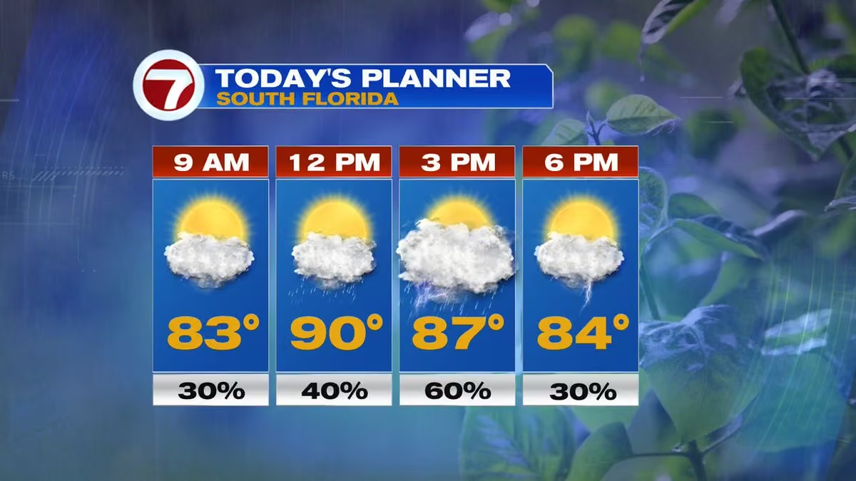
🌦️⛈️ Another active day across South Florida! Morning storms favor the East Coast before shifting inland and toward SW Florida this afternoon. Heavy rain, lightning & gusty winds are the main concerns. Feels like 100–105. @wsvn @7weather #flwx @abcmiami18
 Vivian Gonzalez
@VivianGonzalez7
Rain has been on and off from Central Miami-Dade to the upper Florida Keys. An isolated storms is pushing through West Broward. @wsvn @7weather #flwx @abcmiami18
Vivian Gonzalez
@VivianGonzalez7
🌦️⛈️ TODAY’S DAY PLANNER: Keep the umbrella close! Morning showers & storms favor the East Coast, then activity shifts inland and toward SW Florida this afternoon. Hot & humid with highs in the low 90's and heavy downpours possible. @wsvn @7weather #flwx @abcmiami18
 Vivian Gonzalez
@VivianGonzalez7
We have rain and lightning now located around Pompano Beach and Lauderdale Lakes. @wsvn @7weather #flwx @abcmiami18
Vivian Gonzalez
@VivianGonzalez7
🌀 TROPICS UPDATE: On the climatological peak of Atlantic hurricane season, the basin is quiet! There are no active tropical systems and no tropical development is expected over the next 7 days. Let’s hope this quiet stretch continues! #tropics #flwx @wsvn @abcmiami18 @7weather
Vivian Gonzalez
@VivianGonzalez7
🌀 PEAK OF HURRICANE SEASON: Today, September 10th, marks the climatological peak of Atlantic hurricane season. So far, South Florida has been fortunate. But hurricane season is far from over, so we’ll continue to watch the tropics closely through November 30th. #hurricaneseason
 Vivian Gonzalez
@VivianGonzalez7
Showers and storms are becoming more widespread in Southern Miami-Dade. @wsvn @7weather #flwx @abcmiami18
Vivian Gonzalez
@VivianGonzalez7
Isolated storm has developed and now impacting Key Biscayne. @wsvn @7weather #flwx @abcmiami18
Vivian Gonzalez reposted
 Anthony Duarte
@AnthonyDuarte03
This is going to be an interesting winter 🫣
 Vivian Gonzalez
@VivianGonzalez7
⛈️ STORM TIMING: A few showers may brush the East Coast this morning, then the action shifts west. Scattered to numerous storms favor the interior & Southwest Florida this afternoon, with heavy rain, lightning and gusty winds. @wsvn @7weather @abcmiami18 #flwx
Vivian Gonzalez
@VivianGonzalez7
🌦️ LOOKING AHEAD: More storms are possible Thursday as deeper moisture moves into South Florida. Expect another round of heavy downpours, lightning and gusty winds, with localized flooding possible. @wsvn @7weather #flwx @abcmiami18
Vivian Gonzalez
@VivianGonzalez7
🌊 King tide season is here! Higher-than-normal tides are expected in Key West Sept. 8–11 and Miami Beach/Fort Lauderdale Sept. 10–13. King tides are astronomical, but onshore winds, rain & higher seas can worsen coastal flooding. @wsvn @abcmiami17 #flwx #kingtides @7weather
 Vivian Gonzalez
@VivianGonzalez7
One downpour is going through Palmetto Bay, Cutler Bay and West Perrine. Heavy rain located between US1, SW 184th St and SW 117th Ave. @wsvn @7weather @abcmiami18
Vivian Gonzalez
@VivianGonzalez7
The coverage of showers and storms will be less today, but the best chance will be around interior areas. Highs in the low 90's with steamy sunshine. @wsvn @7weather @abcmiami18 #flwx
 Vivian Gonzalez
@VivianGonzalez7
⛈️ LABOR DAY FORECAST: Keep an eye on the radar if you have outdoor plans today! Scattered to numerous storms develop across South Florida, especially this afternoon. Heavy downpours, frequent lightning & localized flooding are possible. Highs in the low 90's. #laborday @wsvn
 Vivian Gonzalez
@VivianGonzalez7
Some storms are flaring up by extreme southern Miami-Dade and upper Florida Keys. @wsvn @7weather #flwx
Vivian Gonzalez
@VivianGonzalez7
Rain and storms becoming more widespread in Southern Miami-Dade. @wsvn @7weather #flwx
Vivian Gonzalez
@VivianGonzalez7
Some strong storms have developed in Broward and slowly moving North between Dania Beach through Lauderdale Lakes and Tamarac. @wsvn @7weather #flwx
Vivian Gonzalez
@VivianGonzalez7
Periods of moderate to heavy rain impacting your commute in Broward. @wsvn @7weather #flwx @abcmiami18
Vivian Gonzalez
@VivianGonzalez7
Heavy rain and lightning has developed in parts of Miami-Dade. Coral Gables getting the heaviest of the rain, tons of lightning and gusty winds. @wsvn #flwx @7weather @abcmiami18
Vivian Gonzalez
@VivianGonzalez7
Storms developing in Northern Broward and Southern Miami-Dade. @wsvn @7weather #flwx @abcmiami18
Vivian Gonzalez
@VivianGonzalez7
🌴⛈️ Long weekend plans? Keep an eye on the radar! South Florida stays hot & humid with daily afternoon storms. It won’t rain all day, but heavy downpours, lightning & localized flooding are possible. Feels like 103–108 at times. @wsvn @7weather #flwx @abcmiami18
Vivian Gonzalez
@VivianGonzalez7
⛈️ Hot, humid & unsettled! Scattered to numerous storms develop across South Florida this afternoon. Heavy downpours, frequent lightning & gusty winds are possible, along with localized flooding. Highs in the low 90's. @wsvn @7weather #flwx #rain #storms @abcmiami18
 Vivian Gonzalez
@VivianGonzalez7
⛈️ WET WEDNESDAY: Keep the umbrella close! Another round of showers & storms develops across South Florida today. Heavy downpours, frequent lightning, gusty winds & localized flooding are possible. Highs near 90 with a steamy feel. @wsvn #flwx @7weather @abcmiami18
 Vivian Gonzalez
@VivianGonzalez7
More tropical moisture moving through the islands will head toward South Florida, keeping us wetter into the long weekend. Expect rounds of storms. Boaters: watch for lightning, gusty winds & locally rough seas near storms. @wsvn @7weather #flwx #tropics
Vivian Gonzalez
@VivianGonzalez7
⛈️ SOUTH FLORIDA: Keep the umbrella close! Scattered to numerous storms are expected again today with heavy downpours, frequent lightning & gusty winds. Slow-moving storms could also cause localized flooding. Hot & humid with highs in the low 90's. @wsvn #flwx #rain #storms
Vivian Gonzalez
@VivianGonzalez7
TUE 8AM ADVISORY & CONE- Tropical Storm #edouard is just 40 miles SSE of Cameron, LA. NHC says significant strengthening is forecast and Edouard could approach hurricane strength before reaching the NW Gulf Coast later today. @wsvn #tropics @7weather
 Vivian Gonzalez
@VivianGonzalez7
⚠️🌀 EDOUARD ALERTS: A Storm Surge Warning, Hurricane Watch & Tropical Storm Warning are in effect for portions of the Upper Texas and Louisiana coasts as Tropical Storm #edouard approaches. Conditions are expected to deteriorate today. @WSVN #tropics
 Vivian Gonzalez
@VivianGonzalez7
TUE 5AM ADVISORY & CONE- Tropical Storm #edouard is strengthening in the NW Gulf and could approach hurricane strength before reaching the Upper Texas/SW Louisiana coast later today. Storm surge, damaging winds, heavy rain & flash flooding are concerns. @WSVN #tropics @ABCMIAMI18
 Vivian Gonzalez
@VivianGonzalez7
🌀 NEW MON 11AM ADVISORY: Potential Storm Five has formed in the Gulf. A Tropical Storm Warning is now in effect from Port Bolivar, TX to SW Louisiana. The system is forecast to become a tropical storm tonight and reach the coast Tuesday. @wsvn #tropics @abcmiami18 @7weather
 Vivian Gonzalez
@VivianGonzalez7
NHC will be issuing advisories at 11am on Potential Storm Five in the Gulf at 11am. @wsvn @tropics @abcmiami18
Vivian Gonzalez
@VivianGonzalez7
🌧️ WET PATTERN STICKS AROUND: South Florida stays loaded with tropical moisture through the week and into the long weekend. Expect daily storms with heavy downpours, lightning & gusty winds. Not a total washout, but plan outdoor activities around the rain! @wsvn #flwx #tropics
 Vivian Gonzalez
@VivianGonzalez7
🌀 TROPICS UPDATE: Two areas to watch. #invest97l in the northern Gulf has a 70% chance of development before reaching the Upper Texas/SW Louisiana coast Tuesday. #dolly remnants are disorganized near Hispaniola, with redevelopment chances now down to 10%. @wsvn #tropics #flwx
Vivian Gonzalez
@VivianGonzalez7
MON 8AM TROPICS OUTLOOK- Dolly’s remnants remain disorganized. Unfavorable upper-level winds should limit redevelopment over the next few days. 7-day development chance has dropped to 10%. Heavy rain & gusty winds remain possible across parts of the Caribbean & Bahamas. #tropics
 Vivian Gonzalez
@VivianGonzalez7
MON 8AM TROPICS OUTLOOK- Invest 97L continues to show signs of development in the Northern Gulf. A short-lived tropical depression or storm is likely before reaching the Upper Texas or SW Louisiana coast tonight or Tuesday morning. Heavy rain is also expected. @wsvn #tropics
 Vivian Gonzalez
@VivianGonzalez7
🌧️ MESSY MONDAY: Keep the umbrella close! Showers and storms will develop near the East Coast this morning/midday, then shift inland this afternoon. Heavy downpours, gusty winds & localized flooding are possible. Highs near 90°. @wsvn @7weather #flwx @abcmiami18
Vivian Gonzalez
@VivianGonzalez7
⛈️ FRIDAY FORECAST: Another hot & humid day with highs in the low 90's. Storms will develop late morning/early afternoon near the East Coast, then shift inland. A few could pack heavy rain, frequent lightning & gusty winds up to 40–55 mph. @wsvn @7weather #flwx
Vivian Gonzalez
@VivianGonzalez7
Strong isolated storm has developed in Broward. @wsvn @7weather @abcmiami18 #flwx
Vivian Gonzalez
@VivianGonzalez7
🌀 WHY DOLLY WON’T STRENGTHEN: Increasing wind shear, dry air and Dolly’s fast forward speed are working against the storm. NHC expects Dolly to gradually weaken and lose its circulation before reaching the Lesser Antilles this weekend. #tropics #dolly
Vivian Gonzalez
@VivianGonzalez7
FRI 5AM ADVISORY & CONE- Tropical Storm Dolly is moving fast to the West. On the forecast track, this system, or its remnants, should be nearing the Leeward Islands this weekend. @wsvn @7weather #tropics #dolly
 Vivian Gonzalez
@VivianGonzalez7
NEW- THURSDAY 11AM ADVISORY & CONE- Tropical Storm #dolly forms over the Central Tropical Atlantic. It is forecast to degenerate into a tropical wave before it reaches the Leeward Islands this weekend. @wsvn @7weather #tropics @abcmiami18
 Vivian Gonzalez
@VivianGonzalez7
NHC will begin issuing advisories on Tropical Storm #dolly located in the central Tropical Atlantic at 11am. @wsvn @7weather #tropics @abcmiami18
Vivian Gonzalez reposted
National Hurricane Center
@NHC_Atlantic
NHC will initiate advisories on Tropical Storm Dolly (formerly AL96) located in the central Tropical Atlantic, at 1100 AM EDT (1500 UTC).
Vivian Gonzalez
@VivianGonzalez7
THU 8AM TROPICS OUTLOOK- Low pressure (Invest 96L) is getting better organized. If the trend continues, it could become a short-lived tropical depression or storm later today. Conditions become hostile throughout the day on Friday. @wsvn #tropics @abcmiami18
 Vivian Gonzalez
@VivianGonzalez7
🌕 ECLIPSE TONIGHT! A partial lunar eclipse happens when Earth’s shadow covers part of the Moon. Nearly 96% will be covered at its peak just after midnight. Look up, South Florida! 🌎🌙 @wsvn @7weather @abcmiami18 #flwx
 Vivian Gonzalez
@VivianGonzalez7
WED 8AM TROPICS OUTLOOK- invest 96L remains disorganized in the eastern Atlantic, but conditions could support some development over the next couple of days. A tropical depression could form as it tracks W to W/NW. Development chance is now 60% through 48 hours & 7 days. @wsvn
 Vivian Gonzalez
@VivianGonzalez7
Some storms have developed and impacting Sunset, Kendale Lakes, and South Miami. Please be safe as you head out this morning. @wsvn @7weather #flwx
Vivian Gonzalez
@VivianGonzalez7
RAIN CHANCES RISE TODAY: Deeper moisture will fuel more showers & storms across South Florida. Activity may start near the East Coast late morning, then become more numerous inland this afternoon. Heavy rain, frequent lightning & gusty winds are possible. @wsvn #flwx #storms
Vivian Gonzalez
@VivianGonzalez7
🌕 LOOK UP! A partial lunar eclipse will be visible from South Florida Thursday night into Friday. At its peak around 12:12 AM, nearly 96% of the Moon will be covered by Earth’s shadow. 🌎🌙 @wsvn @7weather #flwx #eclipse #moon @abcmiami18
Vivian Gonzalez
@VivianGonzalez7
TUE 8AM TROPICS OUTLOOK- Development chances are increasing in the eastern Atlantic. Invest 96L, S/SE of the Cape Verde Islands, now has a 70% chance of development & is likely to become a tropical depression in the next day or two as it tracks west to W/NW. @wsvn #tropics
 Vivian Gonzalez
@VivianGonzalez7
TUE 8AM TROPICS OUTLOOK- Invest 95L remains a broad, disorganized low a few hundred miles east-northeast of Bermuda. It still has a brief window to become a tropical depression or storm today before conditions turn hostile. Formation chance: 40%. @wsvn @7weather #tropics
 Vivian Gonzalez
@VivianGonzalez7
Isolated storm now moving through parts of Broward. @wsvn @7weather @abcmiami #flwx
Vivian Gonzalez
@VivianGonzalez7
Some storms have developed in coastal Miami-Dade. @wsvn @7weather #flwx @abcmiami18
Vivian Gonzalez
@VivianGonzalez7
🌀 34 YEARS SINCE HURRICANE ANDREW: On Aug. 24, 1992, Category 5 Hurricane Andrew devastated South Florida. Today, we remember those impacted and the lessons that still guide hurricane preparedness. A reminder: Don’t wait for a storm to get ready. #hurricaneandrew @WSVN #flwx
 Vivian Gonzalez
@VivianGonzalez7
MON 8AM TROPICS OUTLOO- A tropical wave has moved off the coast of Africa. Conditions could support gradual development as it tracks W at 15–20 mph across the tropical Atlantic. A tropical depression could form later this week. @wsvn @7weather #tropics
 Vivian Gonzalez
@VivianGonzalez7
MON 8AM TROPICS OUTLOOK- INVEST 95L located a few hundred miles E/SE of Bermuda, continues to show signs of organization. A short-lived tropical depression or storm could form over the next couple of days as it moves N/NE, well NE of Bermuda. @wsvn #tropics @7weather
 Vivian Gonzalez
@VivianGonzalez7
LIGHTNING SAFETY- Remember, when thunder roars, go indoors! If you can hear thunder, you’re close enough to be struck by lightning. Head inside a sturdy building or enclosed vehicle and wait at least 30 minutes after the last thunder before returning outdoors. ⛈️ #flwx @wsvn
 Vivian Gonzalez
@VivianGonzalez7
WILDFIRE SMOKE: Smoke from wildfires in the area could impact parts of South Florida today, especially the Everglades & western suburbs. Reduced visibility & unhealthy air quality are possible in spots. If you smell or see smoke, limit prolonged time outdoors. @wsvn #flwx
 Vivian Gonzalez
@VivianGonzalez7
FRI 8AM TROPICS OUTLOOK- A weak low a few hundred miles E/SE of Bermuda continues to produce disorganized showers & storms. Any development should be slow as it drifts W/SW through Sunday. 10% chance through 48 hours / 20% through 7 days. @wsvn
 Vivian Gonzalez
@VivianGonzalez7
FRI 8AM TROPICS OUTLOOK- Non-tropical low N/NE of the Azores has a 20% chance of development. It could briefly acquire subtropical or tropical characteristics this weekend as it moves toward Portugal & NW Spain. Development chances should end by Sunday night. @wsvn
 Vivian Gonzalez
@VivianGonzalez7
AIR QUALITY ALERT: An Air Quality Alert is in effect for Miami-Dade County until 3pm today due to elevated levels of smoke. Air quality may approach or reach unhealthy levels, so those sensitive to poor air quality should consider limiting prolonged outdoor activity. 🌫️
 Vivian Gonzalez
@VivianGonzalez7
SMELL OF SMOKE- Light winds overnight have helped smoke from the 41- 43 mile mark fire spread eastward into the western metro areas of Miami-Dade. 200 acres have burned and 0% containment. @wsvn @abcmiami18 #flwx #fire #smoke
 Vivian Gonzalez
@VivianGonzalez7
HEAT ADVISORY: It won’t be quite as hot as the last few days, but the humidity will keep it feeling dangerous. A Heat Advisory is in effect for all of South Florida from 11am to 6pm, with feels-like temperatures of 105–110. Afternoon storms should eventually bring some relief.
 Vivian Gonzalez
@VivianGonzalez7
Temperatures are already feeling like the upper 90's to low 100's. @wsvn @7weather #flwx #heat
 Vivian Gonzalez
@VivianGonzalez7
STORMS MAKING A COMEBACK: We start hot and dry, but moisture is increasing as Saharan dust shifts south. Look for scattered late-day storms, with rain chances increasing even more Thursday into the weekend. @wsvn #flwx #heat
Vivian Gonzalez
@VivianGonzalez7
🌡️ CAN MIAMI DO IT AGAIN? Miami reached 100° Tuesday, tying the city’s all-time record. There’s about a small chance Miami reaches 100° again today. The timing of the sea breeze could make all the difference! @wsvn #flwx #heat
 Vivian Gonzalez
@VivianGonzalez7
🥵 ANOTHER SCORCHER: After Miami hit a historic 100° Tuesday, dangerous heat continues today. A Heat Advisory is in effect 11am to 7pm with feels-like temperatures of 105°–112°. Record highs could fall again. @wsvn #flwx #heat

Vivian Gonzalez reposted
Vivian Gonzalez reposted
Vivian Gonzalez
@VivianGonzalez7
Feeling hot already! @wsvn #flwx #heat
 Vivian Gonzalez
@VivianGonzalez7
🌡️ COULD MIAMI HIT 100 degrees? It’s only happened once in recorded history — July 21, 1942. Today’s forecast calls for the upper 90's, but there’s about a 10% chance Miami International Airport reaches 100 degrees. It’s going to be close! @wsvn @7weather #flwx #heat
 Vivian Gonzalez
@VivianGonzalez7
RECORD HEAT WATCH: We could rewrite the record books today! Miami is forecast to reach 98, topping the current record of 96. Fort Lauderdale could come close to its 98 record, while Key West is forecast at 92, just shy of its 95 record. @wsvn #flwx #heat
 Vivian Gonzalez
@VivianGonzalez7
If you're smelling some smoke in Broward, it is because of light winds out of the Northwest helping to spread the smoke from the Palm Beach fire across the area. @wsvn #fire #smoke #flwx
 Vivian Gonzalez
@VivianGonzalez7
HEAT ALERT: South Florida is turning up the heat again today! A Heat Advisory is in effect from 11am–7pm with feels-like temperatures soaring to 105–112. Record highs could also be challenged. Stay hydrated, take breaks and limit time outdoors during peak heating. #flwx #heat
 Vivian Gonzalez
@VivianGonzalez7
Hazy skies continue across South Florida thanks to a layer of Saharan Dust. @WSVN @7WEATHER @ABCMIAMI18 #flwx
Vivian Gonzalez
@VivianGonzalez7
HEAT ADVISORY: Dangerous heat is back across all of South Florida today from 11am -7pm. Highs will soar into the mid to upper 90's with feels-like temperatures of 105–110. Stay hydrated and limit strenuous outdoor activity during the hottest part of the day. 🥵 @wsvn #flwx #heat
 Vivian Gonzalez
@VivianGonzalez7
Another dangerously hot day across South Florida. A Heat Advisory is in effect from 11am–7pm with feels-like temperatures potentially reaching 105–109. Stay hydrated, limit strenuous outdoor activity and take frequent breaks in the shade or A/C. @wsvn @7weather #flwx #heat
 Vivian Gonzalez
@VivianGonzalez7
FRI 8AM TROPICS OUTLOOK- Farther east, Invest 94L could become a tropical depression this weekend or early next week as it tracks west to west-northwest. Development chance is 30% through 48 hours and 50% over 7 days. @wsvn @7weather #tropics
 Vivian Gonzalez
@VivianGonzalez7
FRI 8AM TROPICS OUTLOOK- Development chances continue to drop for Invest 92L, now down to 20%. Even without development, gusty winds and heavy rain are possible across parts of the Lesser Antilles tonight into Saturday. @WSVN @7WEATHER #tropics

Vivian Gonzalez reposted
 7 Weather
@7Weather
#cristobal has reached its demise. It is now a remnant low.
 Vivian Gonzalez
@VivianGonzalez7
Invest 92L has a rough road ahead. It has a high chance in developing, but will be a short-lived system. Forecast calls for it to run into a wall of strong wind shear, so once it reaches the islands this weekend, we will be following the rains. @wsvn @abcmiami18 #tropics
Vivian Gonzalez
@VivianGonzalez7
THU 8AM TROPICS OUTLOOK- Invest 94L is a tropical wave south-southwest of the Cape Verde Islands. Gradual development is possible as it moves west to west-northwest, with a tropical depression possible late this week or this weekend.
 Vivian Gonzalez
@VivianGonzalez7
THU 8AM TROPICS OUTLOOK- Invest 92L is about 1,000 mi. E of Lesser Antilles. Short-lived tropical depression to likely form within the next day. Chance remains high at 80%. Gusty winds & heavy rain possible in the Lesser Antilles FRI night into SAT, regardless of development.
 Vivian Gonzalez
@VivianGonzalez7
🎒☀️ BACK TO SCHOOL, MIAMI-DADE! Wishing students, teachers and parents a great first day! Expect a warm and humid start, then another hot afternoon with a Heat Advisory in effect. Scattered storms may develop later today, so keep the umbrella handy! @wsvn @abcmiami18 #flwx
 Vivian Gonzalez
@VivianGonzalez7
THU 5AM ADVISORY- #cristobal has weakened to a tropical depression over the open Atlantic, about 610 miles west of the Azores. Winds are down to 35 mph as it moves NE at 16 mph. Further weakening is expected, with it forecast to dissipate later today. 🌀 @wsvn @7weather #tropics
 Vivian Gonzalez
@VivianGonzalez7
HEAT ADVISORY: Another dangerously hot day across all of South Florida. The advisory runs from Noon–7pm with feels-like temperatures reaching 105+ degrees. Stay hydrated, take frequent breaks and limit time outdoors during the hottest part of the day. @wsvn #flwx
 Vivian Gonzalez
@VivianGonzalez7
WED 11AM ADVISORY & CONE- Tropical Storm #cristobal forms in the Northern Atlantic. No watches and warnings issued and it will be a short-lived system.

Vivian Gonzalez reposted
National Hurricane Center
@NHC_Atlantic
NHC will initiate advisories on Tropical Storm Cristobal (formerly AL93) located well west-southwest of the Azores, at 1100 AM EDT (1500 UTC).
Vivian Gonzalez
@VivianGonzalez7
WED 10AM TROPICS UPDATE- NEW- Invest 93L is getting better organized and the chance for development has increased to an 80% in the next 2 and 7 days. @wsvn @7weather @abcmiami18 #tropics
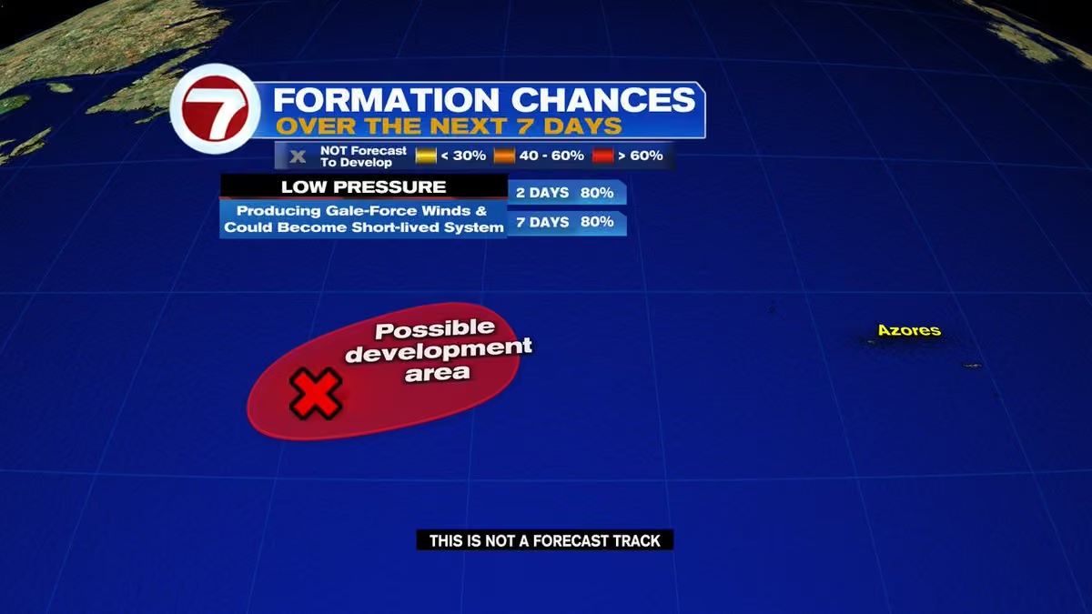 Vivian Gonzalez
@VivianGonzalez7
Invest 93L is over the open central subtropical Atlantic, and the latest models generally keep it well away from the U.S., moving E to Northeast toward the central/northeastern Atlantic. It could become a short-lived tropical storm.
 Vivian Gonzalez
@VivianGonzalez7
We’re watching Invest 92L in the Central tropical Atlantic. Models generally take the system W to W/NW toward the Lesser Antilles over the next several days. It remains far away, and until a center forms, model tracks can change. Plenty of shear also located in the Caribbean.
 Vivian Gonzalez
@VivianGonzalez7
WED 8AM TROPICS OUTLOOK- Invest 93L remains well E/NE of Bermuda with a 50% chance of development. A short-lived tropical storm could still form today as it moves quickly E to E/NE. Cooler waters should end development chances by Thursday. @wsvn @7weather
 Vivian Gonzalez
@VivianGonzalez7
WED 8AM TROPICS OUTLOOK- Another tropical wave just off the coast of Africa is showing some potential for gradual development as it moves W to W/NW. Formation chance: 20% through 48 hours and 30% over 7 days. Plenty of time to monitor this one. @wsvn @7weather
 Vivian Gonzalez
@VivianGonzalez7
WED 8AM TROPICS OUTLOOK- Development chances continue to increase with Invest 92L, now about 900 mi. W/SW of the Cape Verde Islands. A tropical depression will likely form as it moves W to W/NW. Formation chance: 80% through 48 hours. We’ll be watching this one closely. @wsvn
 Vivian Gonzalez
@VivianGonzalez7
COASTAL FLOOD STATEMENT: Minor saltwater flooding is possible again across the Lower Florida Keys, mainly this morning into early afternoon around high tide. Low-lying streets and lots may flood, with some storm drains overflowing. Never drive through flooded roads. 🌊 @wsvn
 Vivian Gonzalez
@VivianGonzalez7
HEAT ADVISORY- Another dangerously hot day is ahead across all of South Florida. The advisory is in effect from Noon to 7pm with feels-like temperatures climbing above 105 degrees in spots. Hydrate, take breaks and limit time in the heat. 🥵 @wsvn @7weather #flwx @abcmiami18
 Vivian Gonzalez
@VivianGonzalez7
It is feeling like the upper 90's already! @wsvn @7weather #flwx @abcmiami18
 Vivian Gonzalez
@VivianGonzalez7
TUE 8AM TROPICS OUTLOOK- An area of low pressure about 500 miles SW of the Cape Verde Islands has a 70% over the next 7 days. A tropical depression will likely form later this week as it moves west to west-northwest across the central Atlantic. We’ll continue to track it. @wsvn
 Vivian Gonzalez
@VivianGonzalez7
TUE 8AM TROPICS OUTLOOK- A disturbance northeast of Bermuda has a low 10% chance of development as it moves east around 20 mph. Cooler waters should end any opportunity for development by Thursday. @wsvn @abcmiami18 @7weather
 Vivian Gonzalez
@VivianGonzalez7
🌊 COASTAL FLOOD STATEMENT: Minor saltwater flooding is possible across the Lower Florida Keys over the next several days, especially around high tide. Low-lying streets and lots may flood, with some seawalls & docks overtopped. Never drive through flooded roads. @wsvn @7weather
 Vivian Gonzalez
@VivianGonzalez7
🥵 HEAT ADVISORY in effect for all of South Florida today from noon- 7pm. Dangerous heat is the main weather story with feels-like temperatures climbing between 105 -108+ this afternoon. Stay hydrated, take frequent breaks and limit strenuous outdoor activity. @wsvn @abcmiami18
 Vivian Gonzalez
@VivianGonzalez7
A quieter start, but rain chances climb as the day goes on. 🌤️🌦️ Look for a few showers around midday with the best chance for downpours and storms during the afternoon. Highs will reach the low 90's before rain helps cool things down. @wsvn #flwx @abcmiami18 @7weather
 Vivian Gonzalez
@VivianGonzalez7
🌧️ Heavy Rain Potential Today: All of South Florida is under a Marginal Risk for excessive rainfall. Downpours could produce heavy rain in a short period of time, leading to localized flooding—especially in poor drainage and flood-prone areas. @wsvn @7weather #flwx @abcmiami18
 Vivian Gonzalez
@VivianGonzalez7
A disturbance near the Bahamas is increasing our rain chances today. A small pocket of drier air is keeping this morning quieter, but deeper moisture later could bring some heavy downpours. Best rain chances will be north.
Keep an eye on the radar if you have afternoon plans!
Vivian Gonzalez
@VivianGonzalez7
NOAA MID-SEASON HURRICANE OUTLOOK UPDATE- The confidence continues to increase (75%) for below-normal activity in the Atlantic Basin due to El Niño conditions. @wsvn @abcmiami18 @7weather
 Vivian Gonzalez
@VivianGonzalez7
Some storms are now rolling through Pinecrest and Palmetto Bay and the heavy rain and lightning stretches into the Turnpike and all the into Krome Ave. @wsvn @abcmiami18 #flwx @7weather
Vivian Gonzalez reposted
 Dylan Federico
@DylanFedericoWX
Colorado State University calls for the least active Atlantic hurricane season in over a decade in their August update. Andrew and Betsy happened in slow seasons so remember it only takes one! #flwx 🌀
 Vivian Gonzalez
@VivianGonzalez7
Showers & isolated storms possible moving onshore through early afternoon. As winds build out of the East today, the sea breeze activity will push inland. Thursday features more of the same with Friday trending wetter due to moisture moving from the Bahamas. @WSVN #flwx
Vivian Gonzalez
@VivianGonzalez7
Some storms have developed and impacting Northern Broward and Southern Palm Beach. @wsvn @7weather #flwx @abcmiami18

Vivian Gonzalez reposted
 NOAA Satellites
@NOAASatellites
Today heavy rainfall may impact parts of the Carolina coast, where some #flood Advisories are in effect, as well as Florida's east coast. @NOAA's #goeseast (#goes19) 🛰️ is monitoring the atmospheric moisture contributing to this threat with its water vapor channel. In this imagery, the yellow/orange areas indicate drier air.
Latest: weather.gov
Vivian Gonzalez reposted
NOAA Satellites
@NOAASatellites
Water vapor imagery from @NOAA's #goeseast (#goes19) 🛰️ shows abundant moisture streaming across the eastern seaboard this morning, where showers and thunderstorms are expected. #flood Watches and Warnings are in effect from the coastal Mid-Atlantic into the Northeast, with #flashflood Warnings spanning parts of New Jersey through Massachusetts.
Latest: weather.gov
Vivian Gonzalez
@VivianGonzalez7
🌤️ Quiet start across most of South Florida this morning, but don't let the sunshine fool you. Warm, humid conditions will fuel another round of afternoon thunderstorms, with the greatest chance for heavy rain and localized flooding later today. @wsvn @7weather #flwx @abcmiami18
Vivian Gonzalez
@VivianGonzalez7
⏰ Today's Timeline
🌤️ Morning: Warm, humid, and a mix of sun and clouds.
⛈️ Afternoon: Scattered to numerous thunderstorms develop.
🌙 Evening: Storms gradually diminish after sunset. @wsvn #flwx @abcmiami18 @abcmiami18
 Vivian Gonzalez
@VivianGonzalez7
🌧️ Keep the umbrella handy today! Slow-moving thunderstorms may dump heavy rain in a short amount of time, creating areas of street and poor drainage flooding, especially in Miami-Dade, Broward, and Palm Beach. @wsvn @7weather #flwx @abcmiami18
 Vivian Gonzalez
@VivianGonzalez7
🌦️ Expect another active summer day across South Florida. Scattered to numerous showers and thunderstorms develop this afternoon, especially across the east coast metro and interior. Some storms could bring heavy rain, frequent lightning, and localized flooding. @wsvn @7weather
Vivian Gonzalez
@VivianGonzalez7
We will be on record watch again for today! @wsvn @7weather @abcmiami18 #flwx
 Vivian Gonzalez
@VivianGonzalez7
HEAT ADVISORY goes into effect at 11am for metro and coastal Broward and Miami-Dade. @wsvn @7weather @abcmami18 #heatsafety #flwx
 Vivian Gonzalez
@VivianGonzalez7
Looking ahead: Friday stays hot with only isolated storms. By Saturday, moisture begins to return, bringing a better chance for scattered afternoon thunderstorms through the weekend. #flwx @wsvn @7weather @abcmiami18
 Vivian Gonzalez
@VivianGonzalez7
🥵 The heat is the biggest weather story today. Temperatures climb into the 90's with "feels like" temperatures over 100. Stay hydrated, take breaks in the shade, and never leave children or pets in a parked vehicle. @wsvn @abcmiami18 @7weather #flwx #heatsafety
 Vivian Gonzalez
@VivianGonzalez7
HOLEY LAND FIRE in NW Broward- 3,900 acres and only 20% contained. The smell of smoke could be felt around portions of South and Central Palm Beach County this morning. @wsvn @7weather #flwx @abcmiami18 #fire
 Vivian Gonzalez
@VivianGonzalez7
HEAT ADVISORY just issued for parts of Broward and Miami- Dade from 11am to 7pm. @wsvn @7weather @abcmiami18 #flwx #heatsafety
 Vivian Gonzalez
@VivianGonzalez7
Lobster Mini Season is underway and will run through tomorrow night. There could be a few PM Showers off the coast with a breezy winds out of the Southwest. Stay safe and don't forget to follow the rules! @wsvn @7weather @abcmiami18 #flwx
 Vivian Gonzalez
@VivianGonzalez7
HEAT RISK is moderate to major for parts of South Florida today. @wsvn @7weather #flwx @abcmiami18
 Vivian Gonzalez
@VivianGonzalez7
Beautiful and colorful start! #flwx @abcmiami18 @7weather @wsvn
 Vivian Gonzalez
@VivianGonzalez7
🚨 HEAT ADVISORY in effect today for parts of South Florida. Heat index values could reach 106°-110° this afternoon. Limit time outdoors, stay hydrated, wear light clothing, and take frequent breaks if you're working or exercising outside.
🥵☀️ #flwx #heatsafety #southflorida
 Vivian Gonzalez
@VivianGonzalez7
Scattered showers & a few storms are already bubbling up across parts of SoFL, especially inland & toward SW Florida. Activity will continue to increase through the afternoon, with storms eventually favoring the east coast. Heavy downpours, lightning & gusty winds possible.
Vivian Gonzalez
@VivianGonzalez7
A 6.8M earthquake struck S of Kumamoto on Japan’s Kyushu island. The shallow quake was caused by movement along a crustal fault, rather than directly along the nearby subduction zone.
We’ll continue to watch for information on impacts and aftershocks as it becomes available. 🌎
 Vivian Gonzalez
@VivianGonzalez7
☀️⛈️ Another hot & humid day across South Florida.
Expect scattered storms to develop this afternoon into early evening, especially across Miami-Dade, Broward & Palm Beach Counties. Some storms could produce heavy rain & street flooding. @wsvn @7weather @abcmiami18 #flwx
Vivian Gonzalez
@VivianGonzalez7
A few showers and storms are lingering over the Gulf waters and Florida Straits this morning, while most of South Florida remains dry. Keep the umbrella handy this afternoon as scattered thunderstorms develop with heavy downpours possible. @wsvn @7weather #flwx @abcmiami18
Vivian Gonzalez
@VivianGonzalez7
After today's scattered inland storms, a wetter pattern settles in this weekend and continues into next week.
Some storms could produce:
⚡ Frequent lightning
💦 Heavy downpours
🌬️ Gusty winds @wsvn @7weather @abcmiami18
Vivian Gonzalez
@VivianGonzalez7
A few coastal showers this morning, then scattered storms develop this afternoon, mainly across inland areas and Southwest Florida.
🌡️ Highs in the low 90's
🥵 Feels like 100°+
⛈️ Storms strongest late afternoon into early evening @wsvn @7weather @abcmiami18 #flwx
Vivian Gonzalez
@VivianGonzalez7
THURSDAY 8AM ADVISORY & CONE- #bertha is moving westward very near the Louisiana coast. @wsvn @abcmiami18 @7weather
 Vivian Gonzalez
@VivianGonzalez7
Coastal flooding possible during times of high tide and Bertha across parts of the Gulf coast. @wsvn @7weather @abcmiami18
 Vivian Gonzalez
@VivianGonzalez7
Today: Hot with scattered storms focused inland and Southwest Florida.
Friday: Increasing moisture and higher rain chances.
Weekend into Early Next Week: More widespread afternoon thunderstorms, especially along the east coast metro areas. @wsvn @7weather @abcmiami18 #flwx
Vivian Gonzalez
@VivianGonzalez7
Isolated storm moving through coastal Broward. @wsvn @7weather @abcmiami18 #flwx
 Vivian Gonzalez
@VivianGonzalez7
THURSDAY 5AM ADVISORY- #bertha is moving Westward South of the Louisiana coast. It is expected to make landfall along the Northwestern Gulf coast today. @wsvn @abcmiami18 @7weather
 Vivian Gonzalez
@VivianGonzalez7
WEDNESDAY 11AM ADVISORY- #bertha is wobbling South of the Mississippi coast. Tropical Storm conditions expected within the warning area through tonight. @wsvn @7weather @abcmiami18
Vivian Gonzalez
@VivianGonzalez7
Tropical Storm Warnings & Coastal Flood Warnings are in effect from southernmost Alabama to the southeast Louisiana coastline. Also, extreme heat expected across these areas. @wsvn @7weather @abcmiami18
Vivian Gonzalez
@VivianGonzalez7
WEDNESDAY 5AM ADVISORY & CONE- #bertha continues westward with tropical storm conditions expected to continue along the northern Gulf Coast. Additional weakening expected as it impacts Louisiana later today. @wsvn @7weather @abcmiami18
 Vivian Gonzalez
@VivianGonzalez7
NEW- WATCHES & WARNINGS- Tropical Storm Watch upgraded to a warning for parts of the Florida Panhandle. Watch expanded Westward to the Vermillion/Cameron Parish Line in Louisiana. @wsvn @7weather #flwx @abcmiami18
 Vivian Gonzalez
@VivianGonzalez7
TUESDAY 11AM CONE- #bertha will move near or along the Northern Gulf Coast during the next several days. Gradual weakening through the middle of the week is expected. @abcmiami18 @wsvn @7weather #flwx
 Vivian Gonzalez
@VivianGonzalez7
TUESDAY 11AM ADVISORY- Air Force Hurricane Hunters find #bertha has strengthened. Winds up to 60mph. It is moving slowly North-Northwest at 3mph. Watches and Warnings have been expanded West. @wsvn @7weather #flwx @abcmiami18
Vivian Gonzalez
@VivianGonzalez7
Live Hurricane Hunter Aircraft data of Tropical Storm #bertha showing winds of up to 60 mph. @wsvn @7weather @abcmiami18 #flwx
Vivian Gonzalez
@VivianGonzalez7
TUESDAY 8AM ADVISORY & CONE- No major changes with the intermediate advisory. A NOAA Hurricane Hunter Aircraft is currently out their investigating #bertha. @wsvn @7weather #flwx
 Vivian Gonzalez
@VivianGonzalez7
Storm Surge Watch: Alabama/Florida Border to the Mouth of the Mississippi River @wsvn @7weather @abcmiami18
 Vivian Gonzalez
@VivianGonzalez7
T.S. Warning: AL/FL border to the Jefferson/Plaquemines Parish border in LA.
T.S. Storm Watch: Bay/Gulf County line in FL westward to the FL/AL border & West of the Jefferson/Plaquemines Parish border to Morgan City, LA. Also, New Orleans, Lake Pontchartrain, & Lake Maurepas.
 Vivian Gonzalez
@VivianGonzalez7
TUE 5AM ADVISORY & CONE- A slow Northwestward to West-Northwestward motion is expected today followed by a turn Westward by Wednesday. On the forecast track, #bertha will gradually weaken & move near or along the Northern Gulf
coast during the next several days. @wsvn @7weather
 Vivian Gonzalez
@VivianGonzalez7
TUE 2AM ADVISORY- Aircraft and satellite wind data indicate that Tropical Storm #bertha is stronger. Winds up to 50 mph. @wsvn @7weather #flwx @abcmiami18
Vivian Gonzalez
@VivianGonzalez7
HEAT ADVISORY starts at 11am for all of Broward and Miami-Dade counties. Practice heat safety South #florida! @wsvn @7weather #flwx @abcmiami18
 Vivian Gonzalez
@VivianGonzalez7
MONDAY 8AM ADVISORY- Tropical Depression #two is expected to become Tropical Storm #bertha this afternoon. Air Force Hurricane Hunter Aircraft currently investigating this system. @wsvn @abcmiami18 #flwx @7weather
 Vivian Gonzalez
@VivianGonzalez7
RAINFALL FORECAST- Models continue to show that Northern Florida will receive periods of heavy rainfall with the bulk located over the Gulf waters. @wsvn @7weather @abcmiami18 #flwx #tropicalupdate #td2
 Vivian Gonzalez
@VivianGonzalez7
NEW- WATCHES & WARNINGS- A Tropical Storm Watch has been issued for the Alabama Gulf coast from the Florida border to the Mississippi border. @wsvn @7weather @abcmiami18 #lfwx
 Vivian Gonzalez
@VivianGonzalez7
MON 5AM ADVISORY & CONE- Tropical Depression #two is expected to become a tropical storm later today. Tropical Storm Watch has been extended to Mississippi/Alabama border. @wsvn @7weather @abcmiami18 #flwx

Vivian Gonzalez reposted
National Hurricane Center
@NHC_Atlantic
July 19: NHC Deputy Director Jamie Rhome provides the LIVE update on Tropical Depression Two from the National Hurricane Center: www.youtube.com/live/l2QZLj9jhSc
For more detailed forecasts and written text updates, visit: hurricanes.gov
Vivian Gonzalez
@VivianGonzalez7
WATCHES & WARNINGS- A Tropical Storm Watch has been issued for #florida from Ochlockonee River to the Alabama border. @wsvn @7weather #flwx @abcmiami18
 Vivian Gonzalez
@VivianGonzalez7
SUNDAY 11AM CONE- Tropical Depression Two is expected to become a tropical storm (#bertha) tonight or on Monday. On the forecast track, it will move near or along the Northern Gulf coast during the next several days. @wsvn @7weather #flwx @abcmiami18
 Vivian Gonzalez
@VivianGonzalez7
NEW- SUNDAY 11AM ADVISORY- Tropical Depression #two forms off the West coast of #florida. A Tropical Storm Watch has been issued for the Florida Panhandle. @wsvn @abcmiami18 #flwx @7weather
 Vivian Gonzalez
@VivianGonzalez7
TROPICAL DEPRESSION #two has formed in the Northeastern Gulf & NHC will start issuing advisories at 11am. @wsvn #flwx @abcmiami18 @7weather
Vivian Gonzalez
@VivianGonzalez7
The biggest threat from Invest 91L will likely be heavy rainfall across portions of the Northern Gulf Coast:
🌧️ Bands of tropical moisture could bring several inches of rain from the Florida Panhandle into parts of Alabama, Mississippi, & Louisiana through midweek. #flwx @wsvn
Vivian Gonzalez
@VivianGonzalez7
MODELS for #invest91l: Forecast guidance continues to show a broad area of low pressure in the NE Gulf gradually organizing over the next 24-48 hours. Most models keep the system moving slowly N toward the Northern Gulf Coast before turning inland early this week. #flwx @wsvn
Vivian Gonzalez
@VivianGonzalez7
SUN 8AM TROPICS OUTLOOK: Disturbance in the NE Gulf continues to show signs of organization, & NHC says a tropical depression is likely to form later today or Monday. Chance up to 80%. Tropical Storm Watches or Warnings may be needed later today for parts of Gulf coast. #flwx
 Vivian Gonzalez
@VivianGonzalez7
SUN 2AM TROPICS OUTLOOK- Invest 91L in the NE Gulf is gradually becoming better organized & now has a 60% chance to develop over the next 48 hours & 7 days. Heavy rain will be the primary concern along portions of the Northern Gulf Coast from Florida to Louisiana. @wsvn #flwx
 Vivian Gonzalez
@VivianGonzalez7
Few spotty showers possible along the coast this morning. Most locations, however, are starting the day with plenty of sunshine & warm temperatures.
Later today, expect a mix of sun & clouds with isolated afternoon storms developing inland & across Southwest Florida. @wsvn #flwx
Vivian Gonzalez
@VivianGonzalez7
FRI 8AM TROPICS OUTLOOK- A tropical wave Southeast of the Cape Verde Islands continues to produce disorganized showers & storms. It is expected to move into a less favorable environment this weekend, limiting development.
 Vivian Gonzalez
@VivianGonzalez7
FRI 8AM TROPICS OUTLOOK- Area of low pressure expected to form over NE Gulf this weekend. It has low chance to form & could meander near the Gulf Coast into early next week. No direct impacts to South #florida are expected, but may increase moisture & storm chances this weekend.
 Vivian Gonzalez
@VivianGonzalez7
MODERATE AIR QUALITY concerns across South Florida due to Saharan dust and grassfires smoke. @wsvn @7weather @abcmiami18 #flwx
 Vivian Gonzalez
@VivianGonzalez7
THU 8AM TROPICS OUTLOOK- A tropical wave Southeast of the Cape Verde Islands in the Eastern Atlantic is expected to move into a less favorable environment this weekend, limiting any significant development.
• 10% in 48 hours
• 10% in 7 days @wsvn @7weather @abcmiami18
 Vivian Gonzalez
@VivianGonzalez7
THU 8AM TROPICS OUTLOOK- An area of low pressure is expected to develop over the Northeastern Gulf this weekend and move toward the Southeast U.S. coast early next week.
• Near 0% in 48 hours
• 20% in 7 days @wsvn @7weather @abcmiami18 #flwx

Vivian Gonzalez reposted
Phil Ferro
@PhilFerro7
In 2007, So Fl is introduced to Meteorologist Vivian Gonzalez. While she is making her on-air debut, she had been working behind the scenes as a producer since 2005. More years to follow.



 Vivian Gonzalez
@VivianGonzalez7
WED 8AM TROPICS OUTLOOK- A potential area of low pressure may develop in the Northeastern Gulf this weekend. Environmental conditions could allow for gradual development early next week. They are giving it a low chance to form. @wsvn @7weather @abcmiami18 #flwx
 Vivian Gonzalez
@VivianGonzalez7
HEAT ADVISORY starts at 11am for parts of South Florida for feel-like temperatures about 105 degrees for a few consecutive hours. #heatsafety @wsvn @7weather @abcmiami18 #flwx
 Vivian Gonzalez
@VivianGonzalez7
HEAT ADVISORY extended for all of South Florida except the Florida Keys. @wsvn @7weather #flwx @abcmiami18
 Vivian Gonzalez
@VivianGonzalez7
If you saw this morning a jellyfish cloud, it was the Falcon 9 launch 29 @starlink satellites to orbit from #florida. Incredible sight! @wsvn @abcmiami18 #flwx @7weather #spacex #starlink #satellites
 Vivian Gonzalez
@VivianGonzalez7
HEAT ADVISORY will run from 11am to 7pm today for dangerously hot feel-like temperatures ranging between 105 to 109 degrees. @wsvn @7weather @abcmiami18 #flwx #heatsafety
 Vivian Gonzalez
@VivianGonzalez7
Even without a Heat Advisory, heat index values between 105 to 110 can be dangerous. We will be under a major to extreme HeatRisk for today. Practice #heatsafety. @wsvn @abcmiami18 @7weather #flwx
 Vivian Gonzalez
@VivianGonzalez7
Expect a hot, hazy day with plenty of sunshine thanks to Saharan dust.
⛈️ Only isolated to scattered afternoon storms are expected, mainly across inland areas, Lake Okeechobee, and Southwest Florida. @wsvn @7weather @abcmiami18 #flwx
Vivian Gonzalez
@VivianGonzalez7
HEAT ADVISORY for South Florida goes into effect at 11am and will run through 7pm. @wsvn @7weather #flwx @abcmiami18
 Vivian Gonzalez
@VivianGonzalez7
It is feeling like 100 in Fort Lauderdale at 9:30am! @wsvn @7weather @abcmiami18 #flwx #heat
 Vivian Gonzalez
@VivianGonzalez7
🎆 Fourth of July Weekend Forecast
Good news!
The holiday weekend looks like a typical South Florida summer:
☀️ Hot mornings
⛈️ Afternoon thunderstorms
🌴 Beach weather early, keep an eye on the radar later. @wsvn @abcmiami18 #flwx @7weather #fourthofjuly
 Vivian Gonzalez
@VivianGonzalez7
🌦️ South Florida Weather Update
Another active summer afternoon is ahead! Expect scattered to numerous thunderstorms with heavy downpours, frequent lightning, and a few gusty winds. Slow-moving storms could cause localized flooding. @wsvn @abcmiami18 #flwx @7weather
Vivian Gonzalez
@VivianGonzalez7
🌡️ Heat & Storms
It's another hot and humid day across South Florida.
🥵 Heat Index: 103-108°
⛈️ Storms develop this afternoon
⚠️ Heavy rain may cause localized street flooding.
Stay weather aware! @wsvn @abcmiami18 #flwx @7weather #heatsafety
 Vivian Gonzalez
@VivianGonzalez7
Rain and storms still in the area under a Street Flood Advisory. @wsvn @7weather #flwx @abcmaimi18
Vivian Gonzalez
@VivianGonzalez7
STREET FLOOD ADVISORY now in effect for parts of Broward & Palm Beach. About 1-3 inches of rain have fallen and flooding could start shortly. Boca Raton, Pompano Beach, Deerfield Beach and Lighthouse Point included in this advisory. @wsvn @7weather #flwx @abcmiami18
 Vivian Gonzalez
@VivianGonzalez7
It is quiet in the Atlantic basin. @wsvn @7weather @abcmiami18 #flwx
 Vivian Gonzalez
@VivianGonzalez7
Smoke from Atlantic Fire in Broward has moved into Miami-Dade with a light Northwest overnight. There are air quality concerns through this morning. @wsvn @7weather @abcmiami18 #flwx
Vivian Gonzalez
@VivianGonzalez7
TUE 8AM TROPICS OUTLOOK- Low pressure along a front has a small window to form as it moves South and then West over the next few days. @wsvn @7weather @abcmiami18 #flwx
 Vivian Gonzalez
@VivianGonzalez7
Isolated storm has developed around Duck Key in the Florida Keys. @wsvn @7weather #flwx
 Vivian Gonzalez
@VivianGonzalez7
You can see smoke from the horizon filtering into Miami-Dade this morning. Also, a tall cloud in the distance associated with a storm currently impacting parts of the Florida Keys. @wsvn @7weather @abcmiami18 #flwx
 Vivian Gonzalez
@VivianGonzalez7
MON 8AM TROPICS OUTLOOK- Disorganized showers & storms located off the SE U.S. coast are associated with an area of low pressure along a front. Conditions only appear marginally favorable for some tropical development over the next day or two as it drifts South & then West.
 Vivian Gonzalez
@VivianGonzalez7
🌦️ MIDWEEK CHANGE- Rain chances increase beginning Tuesday, with the wettest stretch expected Wednesday through Saturday as deeper tropical moisture returns. Keep the umbrella handy later this week! ☔ @WSVN @7WEATHER @ABCMIAMI18 #flwx
 Vivian Gonzalez
@VivianGonzalez7
🌴 SAHARAN DUST- A Saharan Dust is moving into South Florida, bringing slightly drier air, hazier skies, and helping keep storm coverage lower today. #flwx #saharandust @wsvn @7weather @abcmiami18
Vivian Gonzalez
@VivianGonzalez7
THU 8AM TROPICS OUTLOOK- Remnants of #arthur could regenerate into a subtropical or tropical depression once it emerges off the U.S. East coast and into the Western Atlantic Ocean. NHC giving a low chance to form. Regardless, it is producing heavy rainfall across the SE.
Vivian Gonzalez
@VivianGonzalez7
REMNANTS OF ARTHUR- Arthur degenerated into an open area of clouds & rain over SE Texas, but the flooding threat is far from over.
Totals of 5-10 in, with isolated amounts near 20 in, could trigger life-threatening flash flooding from TX to LA & portions of the SE thru Friday.
 Vivian Gonzalez
@VivianGonzalez7
AIR QUALITY CONCERNS- Smoke from Quarry 2, Well Fire, & other wildfire activity in Miami-Dade continues to drift across South Florida today.
Hazy skies & poor air quality possible, especially for sensitive groups & those with asthma or respiratory conditions. #flwx @wsvn #smoke
 Vivian Gonzalez
@VivianGonzalez7
HEAT ADVISORY IN EFFECT TODAY FOR ALL OF SOUTH FLORIDA - From Noon to 7 PM, heat index values will soar to 105-110.
Limit outdoor activities during the hottest part of the day, drink plenty of water, take frequent breaks, & never leave children or pets in a vehicle. #flwx #heat

Vivian Gonzalez reposted
 Jackson Dill
@Jackson_Dill
JUST IN: The Atlantic hurricane season's first named storm -- dubbed #arthur -- is born, currently located right along the Texas coast
 Vivian Gonzalez
@VivianGonzalez7
WED 8AM ADVISORY- Potential Storm #1 has not become better organized yet, but still has a chance to become a tropical depression or storm before pushing inland tonight. @wsvn @7weather @abcmiami18
 Vivian Gonzalez
@VivianGonzalez7
FLOOD ALERTS for parts of the Southeastern U.S. due to Potential Storm #1. @wsvn @7weather @abcmiami18
 Vivian Gonzalez
@VivianGonzalez7
🔥🌫️ FIRE & SMOKE UPDATE
The Quarry 2 & Well Fires continue burning in Western Miami-Dade. Southerly winds today will push smoke North & Northeast, creating hazy skies & potentially impacting air quality across portions of Miami-Dade & Broward. @wsvn @abcmiami18 @7weather #flwx
 Vivian Gonzalez
@VivianGonzalez7
🥵 HEAT ADVISORY 🥵
From Noon to 6 PM, feels-like temps will soar to 105-108 across Miami-Dade & Broward counties.
Limit strenuous outdoor activities during the hottest part of the day, stay hydrated, wear lightweight clothing, & check on children, pets, & vulnerable neighbors.
 Vivian Gonzalez
@VivianGonzalez7
WED 5AM ADVISORY- Potential Storm #1 should move NE the Texas coast today & then move inland over SW Louisiana by tonight. It could still become the first storm of the season later today. Regardless, flooding is a major concern across portions of SE U.S. @wsvn @abcmiami18
 Vivian Gonzalez
@VivianGonzalez7
TUE 11AM ADVISORY & CONE- Potential Storm #1 should move offshore the Texas coast tonight or early Wednesday, move roughly parallel to the upper Texas coast later on Wednesday and move back inland in East Texas or SW Louisiana late Wednesday or early Thursday. @wsvn @abcmiami18
 Vivian Gonzalez
@VivianGonzalez7
NHC will start issuing advisories on Potential Storm #1 at 11am. Watches and warnings coming soon for parts of the Gulf coast states. @wsvn @7weather @Abcmiami18
Vivian Gonzalez
@VivianGonzalez7
Possible record heat for parts of South Florida. Miami has a good chance. @WSVN @7WEATHER #flwx

Vivian Gonzalez reposted
National Hurricane Center
@NHC_Atlantic
NHC will initiate advisories on Potential Tropical Cyclone One (formerly AL90) located over southern Texas, at 1000 AM CDT (1500 UTC).
Vivian Gonzalez
@VivianGonzalez7
Regardless of development with Invest 90L, the biggest threat will be the rain.
⚠️ Main threat: Flash flooding, urban flooding, river flooding
🌬️ Secondary threats: Gusty winds and coastal flooding @wsvn @abcmiami18 #tropics
 Vivian Gonzalez
@VivianGonzalez7
TUE 8AM TROPICS OUTLOOK- INVEST 90L has a 60% chance of becoming a Trop. Depression or short-lived Tropical Storm next 48 hours as it moves near or over NW Gulf. Biggest threat is not the wind—it's the rain. Flooding possible across portions of TX, LA, & MS. @wsvn @abcmiami18
 Vivian Gonzalez
@VivianGonzalez7
⚠️ Hazy skies this morning aren't from clouds.
AIR QUALITY ALERT in effect for Broward until Noon as smoke from the Quarry 2 Fire in Miami-Dade impacts air quality.
If you have respiratory issues or sensitive to smoke, consider limiting outdoor activity. #flwx @wsvn @7weather
 Vivian Gonzalez
@VivianGonzalez7
🔥 The Quarry 2 Fire in Miami-Dade is estimated at 600 acres & 30% contained.
Visibility remains generally good, smoke from the fire is creating a hazy sky across portions of Miami-Dade & Broward as winds push the smoke plume East. We'll continue to monitor conditions. #flwx
 Vivian Gonzalez
@VivianGonzalez7
🥵 HEAT ADVISORY IN EFFECT TODAY 🥵
From Noon to 6pm, feels-like temperatures will soar to 105-107 across Miami-Dade & Broward counties.
Limit time outdoors during the hottest part of the day, stay hydrated, wear lightweight clothing, & check on family, friends, & pets. #flwx
 Vivian Gonzalez
@VivianGonzalez7
Temperatures already feeling like the 90's across all of South Florida. Make sure you stay hydrated if spending a long time outdoors. @wsvn @7weather @abcmiami18 #flwx #heat
 Vivian Gonzalez
@VivianGonzalez7
MON 8AM TROPICS OUTLOOK- Disturbance over NE Mexico continues to produce disorganized shower & storm activity. It will drift Northward over NE Mexico & Southern Texas & could re-emerge over the NW Gulf late Tuesday/Wednesday. Only small chance to form around midweek. @wsvn #flwx
 Vivian Gonzalez
@VivianGonzalez7
MIAMI MATCH- The evening commute and tonight's FIFA match in Miami, we'll be watching a few lingering storms around kickoff. The good news is conditions should improve as the game goes on, with temperatures dropping into the lower 80's by late evening. @wsvn @abcmiami18 #flwx
 Vivian Gonzalez
@VivianGonzalez7
🥵 HEAT ADVISORY in effect today from 11 AM to 6 PM for Miami-Dade & Broward Counties.
Temps. in the low 90's combined with humidity will push feels-like temps to around 105°+. Stay hydrated, limit outdoor activities during peak heat, & never leave children or pets in a vehicle.
 Vivian Gonzalez
@VivianGonzalez7
Here is a check on the tropics. Just watching one area for development. @wsvn @7weather @abcmiami18
Vivian Gonzalez
@VivianGonzalez7
🌦️ The weekend forecast is trending wetter.
Moisture continues to increase across South Florida, bringing higher rain chances Saturday and Sunday with scattered to numerous afternoon thunderstorms expected. @wsvn @7weather @abcmiami18 #flwx
Vivian Gonzalez
@VivianGonzalez7
⛈️ Storm chances increase this afternoon, especially across Southwest Florida, inland communities, and Alligator Alley.
Any storm could bring heavy rain, lightning, and gusty winds. Keep an eye on the radar if you have outdoor plans. @wsvn @7weather @abcmiami18 #flwx
Vivian Gonzalez
@VivianGonzalez7
FRIDAY 8AM TROPICS OUTLOOK- Broad low pressure has formed in the Bay of Campeche. It has a low chance to grow into something stronger before pushing onshore in parts of Mexico Saturday or Sunday. Then it could re-merge into the NW Gulf on Tuesday while interacting with a front.
 Vivian Gonzalez
@VivianGonzalez7
⚽🌎 Opening Day of the FIFA World Cup is finally here!
Fans from around the world are ready and South Florida is proud to be part of the global celebration. Whether you're cheering for your home country or just enjoying the beautiful game, let the matches begin! #fifaworldcup
 Vivian Gonzalez
@VivianGonzalez7
THURSDAY 8AM TROPICS OUTLOOK- Broad area of low pressure could form over the Bay of Campeche on Friday from a Westward-moving tropical wave currently located over the Yucatan Peninsula of Mexico. Low chance to develop before it moves inland over Eastern Mexico Saturday/Sunday.
 Vivian Gonzalez
@VivianGonzalez7
WEDNESDAY AM OUTLOOK- A broad area of low pressure could form over the Bay of Campeche late this week. Conditions are not expected to be favorable for significant development, and the system should move inland over Eastern Mexico late this weekend. @wsvn @7weather @abcmiami18
 Vivian Gonzalez
@VivianGonzalez7
Strong aftershock reported W/NW of Mantua, Cuba last night at around 9:04pm. It was a 4.3 on the earthquake magnitude scale. @wsvn @7weather Flwx @abcmiami18
 Vivian Gonzalez
@VivianGonzalez7
☀️ Hot and humid across South Florida today with a few more clouds!
Most East coast neighborhoods stay dry, while scattered showers & storms develop across the interior & SW Florida this afternoon. Highs near 90 with feels-like temperatures in the low 100's. @WSVN #flwx
Vivian Gonzalez reposted
Vivian Gonzalez reposted
 NHC_TAFB
@NHC_TAFB
6/8: Scattered convection is developing across the central Caribbean as a tropical wave interacts with an upper-level low positioned south of Jamaica. Mariners are advised to anticipate lightning, gusty winds, and confused seas in the vicinity of the strongest thunderstorms.
Vivian Gonzalez reposted
 AZ Intel
@AZ_Intel_
Another video captures the Jollibee building collapse in General Santos, Philippines following powerful earthquake. No word on casualties.
AZ Intel
@AZ_Intel_
NEW VIDEO: Building collapses in General Santos, Philippines following powerful earthquake.
Vivian Gonzalez
@VivianGonzalez7
9AM- Feels like temperatures are already in the 90's! @wsvn #flwx @abcmiami18 @7weather
 Vivian Gonzalez
@VivianGonzalez7
Enjoy the quieter weather while it lasts. 🌤️
Rain chances remain relatively low through midweek, but forecast confidence continues to increase that a wetter pattern will return by Thursday and continue into the weekend. @wsvn @7weather #flwx @abcmiami18
 Vivian Gonzalez
@VivianGonzalez7
☀️ Another hot South Florida day ahead!
Most East coast communities stay dry, while the best chance for a few afternoon showers will be across the interior & Southwest Florida. Highs near 90, with heat index values climbing above 100 in the hottest spots. #flwx @wsvn
Vivian Gonzalez
@VivianGonzalez7
A powerful 7.8 magnitude earthquake struck South of Mindanao in the Philippines. Preliminary estimates indicate millions of people experienced moderate to severe shaking, & significant damage is possible. Aftershocks are expected in the coming days. #earthquake #philippines
 Vivian Gonzalez
@VivianGonzalez7
☀️🌴 Joining me in today’s video forecast is Honorary Meteorologist Avery Ulloa from Saint Mark Catholic School. Avery picked a great weekend to visit — sunshine is back, rain chances are low, and South Florida is finally drying out after a soggy week. @wsvn @7Weather #flwx
Vivian Gonzalez
@VivianGonzalez7
Enjoy the dry weather this weekend because the atmosphere may be loading up again next week. 🌧️📈
Models continue to show a surge of deep tropical moisture returning to South Florida by Tuesday & Wednesday, bringing increasing chances for showers, storms & locally heavy rain.
Vivian Gonzalez
@VivianGonzalez7
After days of heavy rain and flooding concerns, South Florida finally gets a break. ☀️🌴 Drier air has moved in, bringing very low rain chances today and Saturday. Enjoy the sunshine while it lasts! @wsvn @7weather @abcmiami18 #flwx
Vivian Gonzalez
@VivianGonzalez7
Some downpours are developing in Miami-Dade. @wsvn @7weather #flwx
Vivian Gonzalez
@VivianGonzalez7
Not as hot, but still keeping an eye on the rain. 🌦️ A stalled front near South Florida will keep showers and storms in the forecast today. Some areas could see heavy downpours and localized flooding, while others stay mostly dry. @wsvn @7weather #flwx @abcmiami18
Vivian Gonzalez
@VivianGonzalez7
Today's forecast: cooler, cloudy and occasionally wet. 🌧️☁️ Scattered showers and storms remain possible, especially across Miami-Dade and Broward. Street flooding could develop where heavier rain falls over already saturated areas. Highs stay in the low-mid 80's. @wsvn #flwx
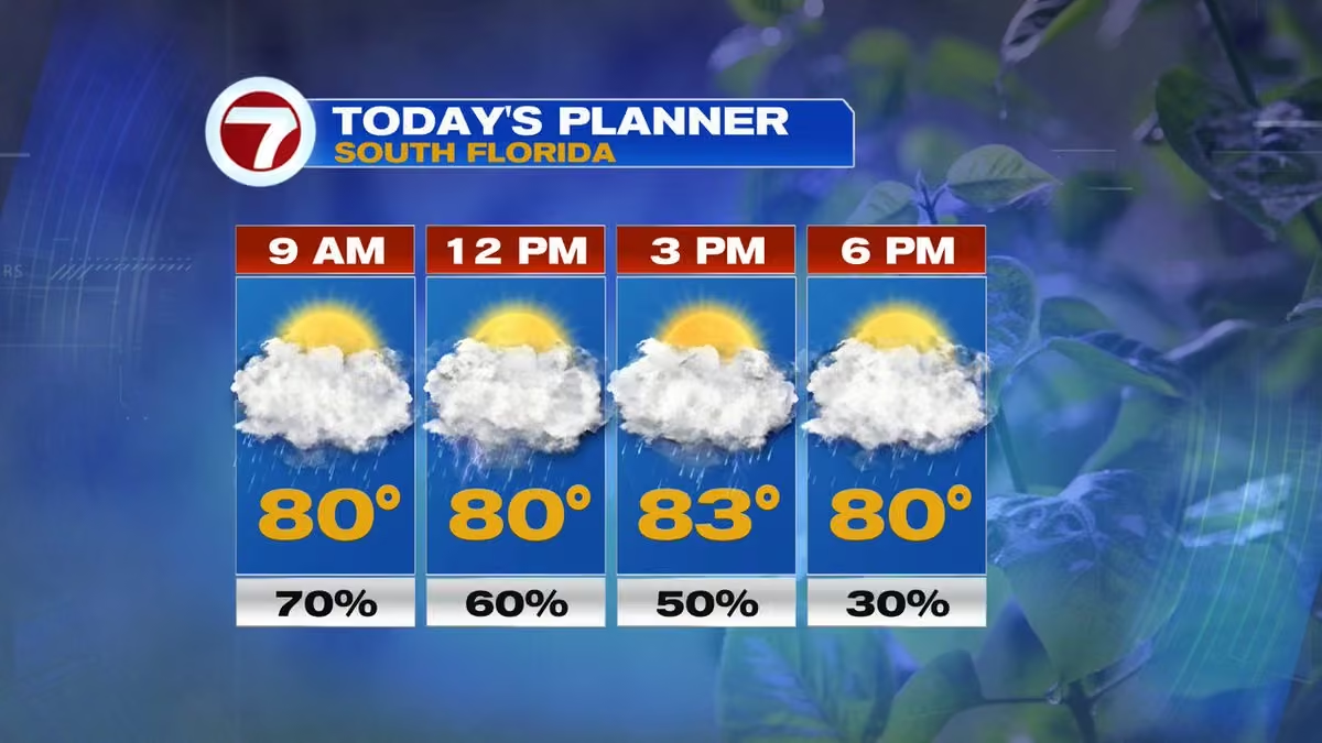 Vivian Gonzalez
@VivianGonzalez7
24 hour rainfall totals. @wsvn @7weather @abcmiami18 #flwx
 Vivian Gonzalez
@VivianGonzalez7
A STREET FLOOD ADVISORY will remain in effect for portions of Miami-Dade through 3:45am. Minor flooding is ongoing or expected to begin shortly in the advisory area. Between 2 and 3 inches of rain have fallen. @wsvn #flwx @ABCMiami18
 Vivian Gonzalez
@VivianGonzalez7
STREET FLOOD ADVISORY for parts of upper Florida Keys until 12:30pm. This includes US 1 between mile markers 66 and 72. @wsvn @7weather #flwx @abcmiami18
 Vivian Gonzalez
@VivianGonzalez7
Some drier air may begin working into parts of South Florida this weekend. Rain chances won't disappear, but coverage should become less widespread compared to the end of the work week. @wsvn @7weather #flwx @abcmiami18
Vivian Gonzalez
@VivianGonzalez7
Storms developing around the #florida Keys. @wsvn @7weather #flwx @abcmiami18
Vivian Gonzalez
@VivianGonzalez7
The SPC maintains a general risk for severe to isolated severe storms across parts of South #florida today. ⛈️ While widespread severe weather isn't expected, a few storms could produce gusty winds, frequent lightning and torrential rainfall leading to flood concerns. @wsvn #flwx
Vivian Gonzalez
@VivianGonzalez7
Today's forecast has a wide range of possibilities. 🌧️ Some models keep rainfall fairly light, while others produce 3-5"+ totals in spots. @wsvn #flwx @abcmiami18 @7weather
 Vivian Gonzalez
@VivianGonzalez7
Forecast Factors: What could change today's forecast?
1️⃣ Extensive cloud cover limiting storm development.
2️⃣ The exact location of the stalled front.
3️⃣ Where heavier rain bands set up.
Small shifts could mean big differences in rainfall totals. @wsvn #flwx @abcmiami18
Vivian Gonzalez
@VivianGonzalez7
June is climatologically one of the quieter months of hurricane 🌀 season, with most early-season development favoring the Gulf, Western Caribbean and waters near #florida. At this time, we are not watching any areas of interest for development. @wsvn @7weather @abcmiami18
 Vivian Gonzalez
@VivianGonzalez7
The 2026 Atlantic Hurricane Season officially started yesterday (6/1) and there are no areas of interest being watched by NHC in the Atlantic Basin. However, in the Eastern Pacific their season started on 5/15 & there are 2 areas being followed for development. @WSVN @7WEATHER
Vivian Gonzalez
@VivianGonzalez7
Heavy rain could lead to localized flooding today. 🌧️ Roads and poor drainage areas could quickly flood where storms repeatedly move over the same location. Be weather aware with your Storm Team if you have afternoon plans. @wsvn @7weather #flwx @abcmiami18
 Vivian Gonzalez
@VivianGonzalez7
Storms could pack a punch this afternoon and evening. ⛈️⚡ A few strong storms may produce damaging wind gusts, small hail, frequent lightning and torrential rainfall, especially across Broward, Northern Miami-Dade, and Palm Beach. @wsvn @7weather #flwx @abcmiami18
Vivian Gonzalez
@VivianGonzalez7
South Florida heats up fast today ☀️🌡️ Highs in the low 90's with heat index values reaching 100-105° this afternoon. We are in a level 2 of 4 Moderate Heat Risk for most of the area. Stay hydrated, take breaks in the shade & limit strenuous outdoor activities during peak heat.
 Vivian Gonzalez
@VivianGonzalez7
Thank you to everyone who stopped by @MODSFTL Eye of the Storm. 🌀
@PhilFerro7 @wsvn @ABCMiami18 #flwx @7Weather
 Vivian Gonzalez
@VivianGonzalez7
🌀 Hurricane season starts June 1. Are you ready?
Join us tonight: Surviving a Storm, our special hurricane preparedness special. Learn how to prepare, protect your family, & stay informed before the next storm threatens South Florida.
📺 7 PM on @wsvn
📺 7:30 PM on @ABCMiami18
 Vivian Gonzalez
@VivianGonzalez7
🌀 Ready for hurricane season?
Join me & Chief Meteorologist @PhilFerro7 at the Eye of the Storm event at the Museum of Discovery & Science! We’ll be talking hurricanes, preparedness, forecasting, & answering your weather questions.
Hope to see you there! 🌴⛈️
@wsvn #flwx

 Vivian Gonzalez
@VivianGonzalez7
Storms are back in the forecast for South Florida today. ⛈️ Expect scattered afternoon and evening thunderstorms with the highest chance across the East coast metro. Frequent lightning, heavy downpours and gusty winds will be possible. @wsvn @7weather #flwx @abcmiami18
Vivian Gonzalez
@VivianGonzalez7
Rainfall so far in the last 6 hours @wsvn #flwx @7weather @abcmiami18
 Vivian Gonzalez
@VivianGonzalez7
SPECIAL MARINE WARNING due to strong storms located along a line extending from Biscayne Bay to Angelfish Key, moving North at 5 to 10 kts. @wsvn #flwx @abcmiami18
 Vivian Gonzalez
@VivianGonzalez7
Storms are ramping up across South Florida and the Storm Team is ready. ⚡️🌴 We’re tracking heavy rain, flooding concerns, lightning and changing conditions through the weekend. Stay tuned to 7Weather for the latest updates wherever you are. #flwx @wsvn
Vivian Gonzalez
@VivianGonzalez7
South Florida turning much wetter and more tropical 🌧️⛈️ Numerous showers and storms are expected through the weekend as deep tropical moisture surges north. Heavy downpours and localized flooding may become a concern, especially across metro areas. @wsvn @7weather #flwx
Vivian Gonzalez
@VivianGonzalez7
STREET FLOOD ADVISORY in effect for parts of Miami-Dade until 10am. @wsvn @7weather #flwx @abcmiami18
 Vivian Gonzalez
@VivianGonzalez7
FLASH FLOODING POSSIBLE- Slow-moving downpours could cause urbanized flash flood concerns this morning. @wsvn @7weather #flwx @abcmiami18
 Vivian Gonzalez
@VivianGonzalez7
Torrential rains happening now in Miami-Dade. This will slow down your commute. Plenty of lightning accompanying this activity. Use caution and be weather aware with your Storm Team. @wsvn #flwx @abcmiami18 @7weather
Vivian Gonzalez
@VivianGonzalez7
STREET FLOOD ADVISORY in effect for parts of the upper Florida Keys until 9am. @wsvn @7weather @abcmiami18 #flwx
 Vivian Gonzalez
@VivianGonzalez7
Showers and storms have developed and training slowly Northward into parts of Miami-Dade. Heavy rain located from Key Largo through Homestead and lightning spotted near Florida City. Don't leave home without the rain gear! @wsvn @7weather #flwx @abcmiami18
Vivian Gonzalez reposted
Phil Ferro
@PhilFerro7
A pool of tropical moisture is set to arrive by Thursday afternoon. It is forecast to sit over the area thru next week. Every day will see a good chance for on & off downpours that could lead to street flooding across SE Florida.
 Vivian Gonzalez
@VivianGonzalez7
Parts of Miami-Dade seeing some heavy rain in Kendall, Pinecrest, Palmetto Bay, and stretching into North Key Largo. Best chance along the East coast this morning. By the afternoon, activity shifts into inland locations. @wsvn #flwx @abcmiami18 @7weather
Vivian Gonzalez
@VivianGonzalez7
Drought-busting rain? Forecast confidence continues increasing for a very active stretch of weather late this week into the weekend. 🌧️ Tropical moisture, slow-moving storms and repeated heavy downpours could lead to areas of street flooding across parts of South #florida. #flwx
Vivian Gonzalez
@VivianGonzalez7
Hot, humid & breezy again today across South Florida ☀️🌴 Highs near 90° with heat index values climbing into the upper 90's and lower 100's. Spotty afternoon storms develop mainly inland & across Southwest Florida. @wsvn #flwx @abcmiami18 @7weather
Vivian Gonzalez
@VivianGonzalez7
South Florida’s weather pattern turns much wetter beginning tomorrow. 🌧️⛈️ Deep tropical moisture surges in with numerous showers and storms expected late week into the weekend. Heavy downpours and localized flooding may become a concern. @wsvn #flwx @abcmiami18 @7weather
Vivian Gonzalez reposted
NHC_TAFB
@NHC_TAFB
5/26 - A deep upper-level trough is drawing abundant tropical moisture northward across the central & eastern Gulf, producing scattered showers and thunderstorms. Mariners should expect gusty winds, frequent lightning, and locally higher seas.
More: hurricanes.gov/marine
Vivian Gonzalez
@VivianGonzalez7
Heads up for the end of the week 👀 Forecast confidence continues increasing for a much more unsettled pattern across South Florida with numerous showers and storms possible by Thursday and Friday. Tropical humidity sticks around into the weekend. @wsvn #flwx @abcmiami18
 Vivian Gonzalez
@VivianGonzalez7
Rainfall totals could really start adding up across South Florida over the next 7-10 days as a wetter tropical pattern develops. 🌧️⛈️ @wsvn @7weather #flwx #abcmiami18
 Vivian Gonzalez
@VivianGonzalez7
South Florida’s weather pattern turns wetter late this week. 🌧️⛈️ Deep tropical moisture moves in beginning Wednesday with rain and storm coverage increasing Thursday into the weekend. Heavy downpours and localized flooding may become possible. @wsvn #flwx @abcmiami18 @7weather
Vivian Gonzalez
@VivianGonzalez7
It is gusty at times across South Florida! @wsvn @7weather #flwx @abcmiami18
 Vivian Gonzalez
@VivianGonzalez7
Looking ahead: The chance is growing for a wetter, more unsettled pattern late this week across South Florida. 🌧️⛈️ Tropical moisture surges in by Wednesday with daily rain and storm chances increasing into next weekend. @wsvn @7weather #flwx @abmiami18
 Vivian Gonzalez
@VivianGonzalez7
Heads up for beachgoers 🌊 A High Risk of rip currents continues along Atlantic beaches through Tuesday evening. Dangerous surf and strong currents remain possible with persistent onshore winds. Swim near a lifeguard and use caution entering the water. @wsvn @abcmiami18 #flwx
 Vivian Gonzalez
@VivianGonzalez7
Hot, humid & breezy Memorial Day across South Florida ☀️🌴 Highs near 90° East coast and low-mid 90's inland/SW Florida with heat index values reaching the upper 90's and low 100's. Spotty afternoon storms develop mainly inland & Gulf coast side. @wsvn @abcmiami18 #flwx @7weather
 Vivian Gonzalez
@VivianGonzalez7
Active fires continue across parts of Broward & Miami-Dade counties. 🔥
MM 44 Fire has grown to 1,200 acres & is 60% contained after being sparked by lightning Saturday. Meanwhile, crews on scene on another grass fire near SW 120th St & SW 137th Ave. It is under control. #flwx
 Vivian Gonzalez
@VivianGonzalez7
Long range trends are pointing toward wetter & more unsettled pattern developing by the end of next week across South Florida. 🌧️⛈️
Expect daily Summer-like storms to become more numerous with tropical humidity sticking around. We'll continue watching forecast trends closely.
Vivian Gonzalez
@VivianGonzalez7
Memorial Day Weekend forecast ☀️🌴⛈️
SATURDAY: Hot, humid & spotty PM storms inland/SW Florida
SUNDAY: Summer-like with highs near 90° & afternoon storms
MEMORIAL DAY: Warm, breezy & tropical with inland storms late day
Beach mornings look best before storms develop. #flwx

Vivian Gonzalez reposted
National Hurricane Center
@NHC_Atlantic
Remember, even if the Atlantic hurricane season ends up being below to near normal, it only takes one storm in your community to make it a bad hurricane season for you. Prepare this year like you would any other!
 NOAA Communications
@NOAAComms
Atlantic #hurricaneseason Outlook 2026: 8-14 named storms of which 3-6 could become hurricanes, including 1-3 major hurricanes:
www.noaa.gov/news-release/noaa-predicts-below-normal-2026…
@NWSCPC #hurricaneoutlook #weatherreadynation
 Vivian Gonzalez
@VivianGonzalez7
NOAA just released the 2026 Atlantic Hurricane Season Outlook calling for a below average season driven by El Niño. @wsvn @7weather @abcmiami18 #flwx
 Vivian Gonzalez
@VivianGonzalez7
Hot, humid & breezy again across South Florida today ☀️🌴 Highs near 90° east coast and mid 90's inland/SW Florida with heat index values reaching the upper 90's and low 100's. Spotty storms develop this afternoon, mainly inland & Gulf coast side. @wsvn @abcmiami18 @flwx
Vivian Gonzalez
@VivianGonzalez7
Over the last 3 hours we had some storms develop in Miami-Dade. The rain now is winding down, but there is some isolated downpours leftover in parts of Broward by 595 in Davie and Plantation. @wsvn @7weather @abcmiami18 #flwx
Vivian Gonzalez
@VivianGonzalez7
Thunderstorm brewing now by Bay Harbor Islands and North Miami Beach. Heavy rain spreading through Pembroke Pines and Miramar. @wsvn @7weather #flwx @abcmiami18
Vivian Gonzalez
@VivianGonzalez7
We have some storms in Miami-Dade and Broward. Periods of heavy rain and lightning happening right now. They are pushing West. #flwx
Vivian Gonzalez
@VivianGonzalez7
South Florida settling into a summer-like pattern ☀️⛈️ Expect hot afternoons in the upper 80's and 90's with daily inland storms through the week. Heat index values could climb into the low 100's at times. @wsvn #flwx @abcmiami18 @7weather
 Vivian Gonzalez
@VivianGonzalez7
Another steamy South Florida day ahead! 🌴☀️ Breezy easterly winds continue with scattered showers this morning & storms developing inland & across Southwest Florida later today. A few storms could produce gusty winds & small hail. @wsvn #flwx @abcmiami18 @7weather
Vivian Gonzalez
@VivianGonzalez7
Miami turned up the heat! 🔥 Yesterday’s high hit 95, tying the record for the date set back in 2019. It was also Miami’s hottest day so far this year and the hottest since August 2025. Summer-like heat arriving early across South Florida. @wsvn #flwx @7weather @abcmiami18
 Vivian Gonzalez
@VivianGonzalez7
Today marks the start of the National Hurricane Center’s daily Tropical Weather Outlooks for the 2026 Atlantic Hurricane Season. 🌀 Right now, no tropical development is expected over the next 7 days, but tropical waves & Saharan dust are already showing up across the Atlantic.
Vivian Gonzalez
@VivianGonzalez7
South Florida’s rainy season officially begins today! 🌦️☀️
The 2026 outlook from NWS calls for:
Below normal rainfall
Above normal temps.
Stormiest months: June & July
Saharan dust arriving late this summer could help limit rainfall & keep us hotter. #flwx @wsvn @7weather
 Vivian Gonzalez
@VivianGonzalez7
South Florida wrapping up the dry season running well below average on rainfall. 🌴☀️
Since October 15:
📍Miami: -7.38”
📍Ft. Lauderdale: -3.15”
📍Key West: -8.39”
Now, as we head deeper into May, daily storm chances begin increasing as wet season patterns slowly return. #flwx
 Vivian Gonzalez
@VivianGonzalez7
A summer-like pattern settling into South Florida! 🌦️ Expect warm temps in the upper 80's to low 90's with spotty afternoon showers and an isolated storm possible. Feels like temperatures around 100 degrees. @wsvn @7weather @abcmiami18 #flwx
 Vivian Gonzalez
@VivianGonzalez7
Another steamy South Florida day ahead ☀️🌡️
Highs in the upper 80's to low 90's with scattered afternoon storms developing later today. Heat index values near 100° before storms help cool things down. @wsvn @7weather @7weather #flwx
Vivian Gonzalez
@VivianGonzalez7
Our future radar shows storms bubbling up inland later today before pushing toward the metro this evening. Some storms could produce heavy rain and isolated areas of street flooding. Keep the umbrella close by this afternoon! ⛈️ @wsvn @abcmiami18 #flwx @7weather
Vivian Gonzalez
@VivianGonzalez7
West winds today could push smoke from wildfire toward the East coast metro at times, including parts of Miami-Dade & Broward. Air quality & visibility could occasionally be reduced, especially near the fire & during lighter winds tonight. Hoping for more rain today in the area.
Vivian Gonzalez
@VivianGonzalez7
Max Road Fire in W. Broward is now up to 11,000 acres & 60% contained. Onshore winds should keep most smoke away from metro areas today, but lighter winds tonight could bring some closer to inland suburbs. Rain/storms may help later today... We need the rain, not the lightning.
Vivian Gonzalez
@VivianGonzalez7
👀⛈️ Storms fire up inland and around Lake Okeechobee later today before drifting toward the East coast metro this evening. Some storms could produce heavy rain, gusty winds, and lightning with isolated areas of street flooding possible. @wsvn @abcmiami18 #flwx @7weather
Vivian Gonzalez
@VivianGonzalez7
Storms develop later today, mainly after lunchtime into the evening. The strongest storms will favor inland areas, then drift toward the East coast metro. A few storms could produce strong wind gusts, frequent lightning, heavy rain, & isolated street flooding. @wsvn #flwx
Vivian Gonzalez
@VivianGonzalez7
Smoke tracker shows the bulk of smoke staying mainly NW near US-27 & Alligator Alley through today. Winds lighten tonight, which could allow smoke to spread into southern Broward & Miami-Dade through tomorrow morning. Hoping beneficial rain with the next front helps. @wsvn #flwx
Vivian Gonzalez
@VivianGonzalez7
Tuesday looks like the more active weather day. Front slowly approaches SoFL, bringing numerous afternoon & evening storms. Some storms could become strong with heavy downpours, street flooding, gusty winds, & frequent lightning — especially across the metro & interior areas.
 Vivian Gonzalez
@VivianGonzalez7
Fires around South #florida keeping skies hazy. @wsvn @7weather #flwx @abcmiami18
 Vivian Gonzalez
@VivianGonzalez7
🔥 South Florida stays hot and humid today with feels-like temperatures around 100°. Scattered thunderstorms develop this afternoon and evening, especially inland and near Lake Okeechobee. A few storms could bring gusty winds, heavy rain, and lightning. @wsvn @abcmiami18
Vivian Gonzalez
@VivianGonzalez7
MAX ROAD FIRE- Winds became light & variable overnight & with high humidity, it helps trap the smoke near the surface & spread. That is why the smell of smoke this morning is more intense especially in West Broward. It is over 5,000 acres & 20% contained as of update last night.
Vivian Gonzalez reposted
Dylan Federico
@DylanFedericoWX
#breaking: A major wildfire has erupted near the Miami-Dade & Broward county border. It is currently 0% contained. #flwx 🔥
📸 @VivianGonzalez7
@NWSMiami @wsvn
 Vivian Gonzalez
@VivianGonzalez7
Happy Mother’s Day! 🌷🌸💕
#family #blessed
 Vivian Gonzalez
@VivianGonzalez7
🚨 Large brush fire burning out west sending smoke/haze across parts of South Florida this afternoon. The smoke plume is so dense, it’s even showing up on radar near western Broward/Miami-Dade. #flwx #miami #broward #brushfire @wsvn @7weather @ABCMiami18
 Vivian Gonzalez
@VivianGonzalez7
🌸☀️ Mother’s Day Forecast: Hot & mostly dry across South Florida! Expect sunshine, highs near 90°, and Summer-like humidity. Perfect for brunches, beach plans, and outdoor celebrations — just stay hydrated! @WSVN @7WEATHER @ABCMIAMI18 #flwx
 Vivian Gonzalez
@VivianGonzalez7
RAINY SEASON outlook was issued by NWS and they are calling for warmer and drier conditions through October. El Niño will be responsible for this pattern. Our stormiest period should be between June and July until Saharan Dust settled in July. @wsvn #flwx @abcmiami18
 Vivian Gonzalez
@VivianGonzalez7
South Florida is entering a dangerously hot stretch, especially for early May. A Major Heat Risk is expected this weekend & some areas could even briefly approach Extreme Heat Risk levels. Heat index values expected in the upper 90's today & could top the low 100's Sunday. #flwx
Vivian Gonzalez
@VivianGonzalez7
We will be on record watch today. Miami and Key West could come close! @wsvn @7weather #flwx @abcmiami18
 Vivian Gonzalez
@VivianGonzalez7
TORNADO WATCH in effect for portions of North #florida through 9am. @wsvn @7weather #flwx @abcmiami18
Vivian Gonzalez
@VivianGonzalez7
Heat ramps up even more for Friday with many areas reaching the low to mid 90's. Getting close to records... Heat index values could top 100° increasing concern for heat-related impacts. @wsvn @7weather @abcmiami18 #flwx
 Vivian Gonzalez
@VivianGonzalez7
Today through Friday looks mainly quiet across South Florida with lots of sunshine, low rain chances, and building heat. @wsvn @7weather #flwx @abcmiami18

Vivian Gonzalez reposted
Vivian Gonzalez
@VivianGonzalez7
The first of two full moons of May is happening today. It is the known as the Flower Moon. The name coincides with the abundance of flowers blooming in Spring. Peak time is 1:23pm, but the best viewing will be tonight once the moon rises at 8:06pm. @wsvn @7weather #flwx
 Vivian Gonzalez
@VivianGonzalez7
Records will be in jeopardy also for Saturday. It will be very hot! @wsvn @7weather #flwx @abcmiami18
 Vivian Gonzalez
@VivianGonzalez7
Enjoy the sunshine now- the heat peaks this weekend before storms return. By Sunday, a front approaches, bringing increasing rain chances for showers & storms into early next week, along with the potential for heavy rain at times. @wsvn @abcmiami18 #flwx @7weather
Vivian Gonzalez
@VivianGonzalez7
HEAT RISK- Near record heat across most of the region on Saturday as the probability is increasing of Major Heat Risk (Level 3 of 4) along the East coast of South Florida. Feels like temperatures will be in the low 100's in some areas. Stay cool South Florida! @wsvn @7weather
 Vivian Gonzalez
@VivianGonzalez7
MELTING INTO MAY- Near record heat possible this afternoon. @wsvn @abcmiami18 #flwx @7weather
 Vivian Gonzalez
@VivianGonzalez7
Saturday gets even hotter. With increasing humidity & Southerly breeze, heat index values could reach triple digits, especially across the East coast metro. There’s a growing chance of a Major Heat Risk, meaning the heat could impact anyone without proper hydration or cooling.
Vivian Gonzalez
@VivianGonzalez7
The big story for us is the heat! Forecast high for Miami is 90! A dry pattern remains in place today, with temperatures climbing into the upper 80's and low 90's by the afternoon. @wsvn @7weather #flwx @abcmiami18
Vivian Gonzalez
@VivianGonzalez7
HINT OF HAZE- This morning, smoke from the Highway 41 Wildfire may drift into parts of the Miami metro areas, leading to reduced air quality and visibility. @wsvn @7weather #flwx @abcmiami18
 Vivian Gonzalez
@VivianGonzalez7
Wind direction change is bringing smoke from the Highway 41 Fire our way. It will be thicker in Central & Southern Miami-Dade this morning with a thinner layer spreading into Broward by the afternoon. Hazy sunshine expected today with a hint of smoke in the air. @wsvn #flwx
Vivian Gonzalez
@VivianGonzalez7
A better rain chance returns for the second half of the weekend. @wsvn @7weather @abcmiami18 #flwx
 Vivian Gonzalez
@VivianGonzalez7
Temperatures will remain above average through the weekend. It will be Summer-like starting tomorrow with highs in the low 90's. @wsvn @7weather #flwx @abcmiami18
 Vivian Gonzalez
@VivianGonzalez7
JUST IN- HIGHWAY 41 WILDFIRE is at 6,659 acres. It remains active and 0% contained. @WSVN @ABCMIAMI18 #flwx @7WEATHER
 Vivian Gonzalez
@VivianGonzalez7
Spotty shower moving through Miami Beach. A few additional showers have developed East of Key Biscayne. @wsvn @abcmiami18 #flwx @7weather
Vivian Gonzalez
@VivianGonzalez7
UPDATE- Highway 41 Fire- 5,000 acres burned and it remains 0% contained. @wsvn #flwx
 Vivian Gonzalez
@VivianGonzalez7
Smoke from a Highway 41 Wildfire in Western Miami-Dade could lead to reduced visibility, especially well West of the metro areas. If you’re traveling inland, be mindful of changing conditions on the roads. The wind shifts tomorrow & it could send some smoke towards the coast.
Vivian Gonzalez
@VivianGonzalez7
Active grass fire in West Miami-Dade. It is the Highway 41 Fire. About 450 acres have burned and it is 0% contained. This is located in an area of extreme drought conditions. No road closures have been reported. @wsvn @7weather @abcmiami18 #flwx
 Vivian Gonzalez
@VivianGonzalez7
Severe storms & the threat for heavy rainfall will move into the mid-Mississippi & lower Ohio Valleys today. There is potential for a few strong tornadoes, damaging wind gusts, large hail, & scattered flash flooding @wsvn @7weather @abcmiami18 #flwx
Vivian Gonzalez
@VivianGonzalez7
South Florida will see one more round of isolated to scattered storms this afternoon, mainly inland & SW Florida as a weakening front moves through. Coverage won’t be widespread, but a few storms could be on the stronger side with heavy downpours, gusty winds, & small hail. @wsvn
Vivian Gonzalez
@VivianGonzalez7
Patchy areas of fog around inland locations. Use extra caution while driving this morning. @wsvn @7weather @abcmiami18 #flwx
 Vivian Gonzalez
@VivianGonzalez7
A disturbance is moving through South #florida. Best rain chance is for the Florida Keys. However, with some sun and moisture in the air, isolated storms possible developing inland and pushing towards the coast. @wsvn @7weather @abcmiami18 #flwx
Vivian Gonzalez
@VivianGonzalez7
Spotty showers have been impacting mainly Broward County this morning. @wsvn @7weather #flwx @abcmiami18
Vivian Gonzalez
@VivianGonzalez7
It is not as breezy today. However, a few spotty showers likely today moving in from the Atlantic. By tomorrow, a disturbance in the Gulf increases rain chances for Southern portions of the area. Best chance for the Florida Keys in the morning. Improving by afternoon. @WSVN #flwx
Vivian Gonzalez
@VivianGonzalez7
Drought conditions and winds fueling the fire in Broward county. Winds carrying the smoke West into Alligator Alley and the Everglades. For now it is 25% contained. @wsvn @abcmiami18 #flwx @7weather
Vivian Gonzalez
@VivianGonzalez7
It’s breezy and mostly dry, but keep an eye on strong winds, rough marine conditions, and dangerous rip currents along the coast. Winds will ease up gradually by the end of the week. @wsvn @abcmiami18 #flwx @7weather
Vivian Gonzalez
@VivianGonzalez7
The watch was upgraded to a BRUSH FIRE WARNING for parts of SW #florida. @wsvn @abcmiami18 #flwx @7weather
 Vivian Gonzalez
@VivianGonzalez7
BRUSH WATCHES & WARNINGS in effect for portions of #florida due to the extra dry air building into the region. A combination of strong winds, low humidity, and dry vegetation could start and spread brush fires. @wsvn @7weather @abcmiami18 #flwx
 Vivian Gonzalez
@VivianGonzalez7
It is gusty outside! Wind gust in Pompano Beach up to 32 mph. @wsvn @7weather @abcmiami18 #flwx
 Vivian Gonzalez
@VivianGonzalez7
The wind will be increasing tonight as a front slides South of the area. Water woes likely sticking around for a few days. @wsvn @7weather #flwx @abcmiami18
 Vivian Gonzalez
@VivianGonzalez7
MESSY MONDAY? A cold front will approach South Florida today, bringing scattered showers & storms through this evening. Best chance is between 2 to 6 pm. Main hazards include: Brief downpours that could lead to street flooding issues, gusty winds & small- size hail. @wsvn #flwx
Vivian Gonzalez
@VivianGonzalez7
A powerful 7.4 magnitude earthquake struck off the Northern Japanese coast. The tsunami threat has passed. @wsvn @7weather #flwx @abcmiami18
 Vivian Gonzalez
@VivianGonzalez7
Some moisture is moving in from the Bahamas, so look for spotty showers through the morning. It should be dry for most this afternoon. Moisture levels increase from the South & North heading into Sunday ahead of a front. @wsvn @abcmiami18 @7weather #flwx
Vivian Gonzalez
@VivianGonzalez7
The warming continues into the weekend with highs climbing into the upper 80's & feeling like the 90's. Pop-up storms possible late Sunday with a better rain chance on Monday due to a front. @wsvn @7weather #flwx @abcmiami18
Vivian Gonzalez
@VivianGonzalez7
Clouds are starting to break apart and it should be brighter overall today. @wsvn @7weather @abcmiami18 #flwx
Vivian Gonzalez
@VivianGonzalez7
Drought conditions improving gradually since we had rain last week. Inland areas of Dade and Broward went from severe status to moderate and along the coast now abnormally dry. @wsvn @abcmiami18 @7weather #flwx
 Vivian Gonzalez
@VivianGonzalez7
Rainy Season starts officially in 29 days and the Atlantic Hurricane Season in 46 days. @wsvn @abcmiami18 #flwx @7weather
 Vivian Gonzalez
@VivianGonzalez7
Clouds moving in and out across South Florida. They are not producing showers. Later today more sunshine will be around. @wsvn @7weather @abcmiami18 #flwx
Vivian Gonzalez
@VivianGonzalez7
Along the East coast, highs will reach the low to mid 80’s. However, with an Easterly breeze, it will stay a bit cooler near the coast during the day, but still warm and comfortable overall. @wsvn @7weather @flwx @abcmiami18
 Vivian Gonzalez
@VivianGonzalez7
High pressure is firmly in control, keeping rain chances very low and allowing temperatures to climb. @wsvn @7weather @abcmiami18 #flwx
Vivian Gonzalez
@VivianGonzalez7
WIND ADVISORY going into effect tonight for parts of the East coast of #florida where the front is stalling. @wsvn @7weather #flwx @abcmiami18
 Vivian Gonzalez
@VivianGonzalez7
Heavy rainfall in rounds possible today. Flooding threat is higher and will depend wherever the heaviest rain develops. @wsvn @abcmiami18 @7weather #flwx
 Vivian Gonzalez
@VivianGonzalez7
LAST 6 HOURS- Rain so far... @wsvn @abcmiami18 #flwx @7weather
 Vivian Gonzalez
@VivianGonzalez7
Storms have developed on the bayside by the upper Florida Keys. They are not moving much, so expected periods of heavy rain, lightning and gusty winds from Key Largo through Islamorada. @wsvn @abcmiami18 #flwx @7weather
Vivian Gonzalez
@VivianGonzalez7
Pockets of heavy rain now moving into Broward from the South. Lightning located in Western areas along US 27 and I75. Rainfall rates in Weston between 4-6 inches. @wsvn @7weather @abcmiami18 #flwx
Vivian Gonzalez
@VivianGonzalez7
Rain and storms impacting Miami-Dade right now. It is slowly lifting North. @wsvn @abcmiami18 #flwx @7weather
Vivian Gonzalez
@VivianGonzalez7
Please be weather aware with your Storm Team and remember that if you can't see where the road starts or ends, turnaround and take another route. @wsvn @abcmiami18 @7weather #flwx
 Vivian Gonzalez
@VivianGonzalez7
FLOOD WATCH is in effect for the East coast metro areas of Miami-Dade and Broward until 10 pm tonight. Multiple rounds of heavy rainfall could lead to areas of street flooding. @wsvn @abcmiami18 @7weather #flwx
 Vivian Gonzalez
@VivianGonzalez7
WPC has a marginal risk of excessive rainfall along the Atlantic coast of Florida from Tuesday through Thursday. Rainfall amounts of 2 to 3 inches likely, with higher amounts of 4 to 6 inches possible. This may lead to areas of street flooding. @wsvn #flwx @abcmiai18 @7weather
Vivian Gonzalez
@VivianGonzalez7
Today will be warm, humid & a mix of sun and clouds. A few showers will move in off the Atlantic this morning, with storms developing inland & toward SW FL later this afternoon. Some of those storms could be strong, especially across interior areas. Highs will reach the mid 80's.
Vivian Gonzalez
@VivianGonzalez7
It is going to be a Good Friday with an isolated passing shower through Saturday. A few more showers possible during the day on Easter Sunday. @wsvn @7weather @abcmiami18 #flwx
 Vivian Gonzalez
@VivianGonzalez7
ED ANSIN BEST BUDDIES FRIENSHIP WALK is happening tomorrow @loanDepotpark. The walk begins at 9:25am and it will be warming up into the mid 70's. Small chance of a passing shower. It should be mainly dry. Hope you can join us! @WSVN @ABCMIAMI18 #flwx @7WEATHER
 Vivian Gonzalez
@VivianGonzalez7
Better chance today with a slot of drier air building in temporarily for Good Friday. Heading into Easter Sunday, the chance goes up during the day and the pattern becoming more unsettled next week. @wsvn @abcmiami18 #flwx @7weather
 Vivian Gonzalez
@VivianGonzalez7
Small wrinkle near us sending moisture our way. Expect scattered showers & isolated storms to develop, especially late this morning into the afternoon. Rain will likely start near the East coast before shifting inland & toward SW Florida later in the day with the sea breeze.
Vivian Gonzalez
@VivianGonzalez7
ARTEMIS II- 1st crewed mission to the Moon in over 50 years. This mission will test the Orion spacecraft & SLS rocket with astronauts on board- laying the groundwork for long-term lunar living & future missions to Mars. The next era of human space exploration is almost here!


 Vivian Gonzalez
@VivianGonzalez7
The Full Pink Moon is happening tonight and it is named for the creeping phlox, a wildflower that blooms early in North America, signaling Spring's arrival. @wsvn @abcmiami18 #flwx @7weather
 Vivian Gonzalez
@VivianGonzalez7
NATIONAL WALKING DAY- Great day to enjoy a walk outside with breezy and bright conditions. Temperatures will feel pleasant with highs in the low 80's. @wsvn @7weather #flwx @abcmiami18 #nationalwalkingday
Vivian Gonzalez
@VivianGonzalez7
A brief shower possible through early afternoon. It should be bright and breezy with a pleasant feel. Highs climb into the upper 70's to low 80's. @wsvn @7weather #flwx @abcmiami18
Vivian Gonzalez
@VivianGonzalez7
Although we've seen brief pockets of rain, in the last 12 hours some areas have received slightly better than 1 inch. @wsvn @7weather #flwx #abcmiami18
 Vivian Gonzalez
@VivianGonzalez7
Scattered downpours possible through early afternoon. @WSVN @7weather @abcmiami18 #flwx
Vivian Gonzalez
@VivianGonzalez7
South Florida the first half of the day will feature more clouds & downpours, but it should improve in the afternoon with a little more sunshine to help temperatures climb to about 80 degrees. Slight chance of quick-moving showers tonight. @wsvn @7weather @abcmiami18 #flwx
 Vivian Gonzalez
@VivianGonzalez7
Gusty winds will maintain hazardous seas across the local Atlantic waters through at least mid-week. Seas will begin to slowly subside over the course of today, but are still forecast to remain in the 7-8 feet through this evening. High Surf Advisory for Palm Beach. @wsvn #flwx
 Vivian Gonzalez
@VivianGonzalez7
EARTHQUAKE 7.3 magnitude happened near the island of Espiritu Santo in the Vanuatu island chain of the SW Pacific Ocean. It was a result of reverse movement with horizontal strike-slip movement near the boundary between the Australia and Pacific plates. No tsunami expected. @wsvn
 Vivian Gonzalez
@VivianGonzalez7
Big weekend in South Florida and keep in mind that Sunday will be windier and wetter. There is a chance of seeing an isolated storm in the afternoon. @wsvn @7weather @abcmiami18 #flwx
 Vivian Gonzalez
@VivianGonzalez7
Friday will be gorgeous with Spring warmth. Best chance of seeing an isolated shower will be this morning. By the afternoon, the sea breeze pushes inland. Temperatures will climb into the low to mid 80's and most areas are expected to be dry. @wsvn @7weather @abcmiami18 #flwx
Vivian Gonzalez
@VivianGonzalez7
It will be turning breezy on Saturday as a front moves in. However, windy to gusty winds up to 30 mph possible on Sunday. Expect rough seas for a few days. @wsvn @7weather @abcmiami18 #flwx
Vivian Gonzalez
@VivianGonzalez7
A few isolated showers possible through Saturday, but most areas will likely be dry. By Sunday, a front moves in and stalls with increasing clouds, showers and wind. It will be gusty at times. @wsvn @7weather @abcmiami18 #flwx
 Vivian Gonzalez
@VivianGonzalez7
A 7.5 magnitude earthquake happened overnight and was felt in the Pacific Islands nation of Tonga. No tsunami expected. @wsvn @7weather #flwx @abcmiami18
Vivian Gonzalez
@VivianGonzalez7
Spring officially starts today! @wsvn @abcmiami18 #flwx @7weather
 Vivian Gonzalez
@VivianGonzalez7
Coastal areas have been dealing with clouds & rain showers, while inland areas & Florida Keys remain mostly sunny & dry. A chance still possible through early afternoon. Drier air build late with the weekend looking beautiful & near average. @wsvn @7weather @abcmiami18 #flwx
Vivian Gonzalez
@VivianGonzalez7
It is brighter, comfortably cool & breezy. Look for a few coastal showers today and highs climbing in the mid to upper 70's. @wsvn @abcmiami18 #flwx @7weather
Vivian Gonzalez
@VivianGonzalez7
Have the rain gear with you because with the thick clouds around, some showers possible at any time today. @wsvn @7weather #flwx @abcmiami18
Vivian Gonzalez
@VivianGonzalez7
Temperatures in the 60's across the Florida Keys with a few spots in the upper 50's. @wsvn @abcmiami18 @7weather #flwx
 Vivian Gonzalez
@VivianGonzalez7
Temperatures also in the 50's in Southern Miami-Dade. @wsvn @7weather @abcmiami18 #flwx
 Vivian Gonzalez
@VivianGonzalez7
Temperatures now in Northern Miami-Dade. @wsvn @7weather @abcmiami18 #flwx
 Vivian Gonzalez
@VivianGonzalez7
Temperatures are in the 50's to start in Broward. @wsvn @7weather @abcmiami18 #flwx
 Vivian Gonzalez
@VivianGonzalez7
NEW record on Monday in Marathon with over 2 inches of rain. @wsvn @7weather @abcmiami18 #flwx
 Vivian Gonzalez
@VivianGonzalez7
An earthquake with a magnitude of 5.8 struck off the Southeast coast of Cuba overnight. There were no initial reports of material damage and no tsunami warning. @wsvn @7weather @abcmiami18 #flwx
 Vivian Gonzalez
@VivianGonzalez7
Cloudy and wet start. Grab the rain gear and head out a little earlier. A front is moving through, but it will leave plenty clouds behind and the potential for showers. @wsvn @abcmiami18 @7weather #flwx
Vivian Gonzalez
@VivianGonzalez7
Once the front moves in, the air will cool down (lows in the low to mid 60's). However, clouds and moisture will be left behind as the front stalls to our South & disturbance pumps in moisture. A building breeze out of the North-Northeast expected making for rough seas. @wsvn
 Vivian Gonzalez
@VivianGonzalez7
A few storms could become strong, with the potential for damaging wind gusts & small hail. Brief street flooding is also possible. Later tonight, a line of showers & storms is expected to move through South Florida between about 8 pm & 2 am as the front pushes across the region.
 Vivian Gonzalez
@VivianGonzalez7
Isolated strong to severe storms can't be ruled out going into the weekend with the activity that forms. Be weather aware with your Storm Team. @wsvn @abcmiami18 @7weather #flwx
 Vivian Gonzalez
@VivianGonzalez7
Heavy rain has developed along the coast in Miami-Dade. Please use caution while driving. @wsvn @7weather @abcmiami18 #flwx
Vivian Gonzalez
@VivianGonzalez7
Some showers are developing in Miami-Dade. @wsvn @abcmiami18 #flwx @7weather
Vivian Gonzalez
@VivianGonzalez7
A front is set to move in and stall nearby on Friday. Therefore, it is going to turn warmer & wetter. Scattered showers & storms through the weekend. Another front moves in next Tuesday leaving a rain chance & temperatures cooling down a little mid-week. @wsvn #flwx @abcmiami18
Vivian Gonzalez
@VivianGonzalez7
DENSE FOG ADVISORY issued again for inland Broward and Miami-Dade until 9am. Visibility reduced to a quarter mile or less. @wsvn @7weather @abcmiami18 #flwx
 Vivian Gonzalez
@VivianGonzalez7
DENSE FOG ADVISORY issued again for inland Broward and Miami-Dade until 9am. Visibility reduced to a mile or less well inland. @abcmiami18 @wsvn @7weather #flwx
 Vivian Gonzalez
@VivianGonzalez7
DENSE FOG ADVISORY issued for inland Broward and Miami-Dade until 9am. @wsvn @7weather @abcmiami18 #flwx
 Vivian Gonzalez
@VivianGonzalez7
The smoke from the warehouse fire is being carried to the Northwest and the air quality is reduced for parts of Northern Miami-Dade into Broward. Winds remain breezy out of the East-Southeast. @WSVN @7WEATHER #flwx @abcmiami18
Vivian Gonzalez
@VivianGonzalez7
SMOKE from the fire in NW Miami-Dade is a bit lower to the ground this morning & moving towards the Florida Turnpike due to the wind out of the East-Southeast. People in the area sensitive to smoke, try to limit your outdoor activities or take the proper precautions. @WSVN #flwx
 Vivian Gonzalez
@VivianGonzalez7
Gusty downpour moving through Broward between Pembroke Pines and Davie. It is moving West. @wsvn @abcmiami18 #flwx @7weather
 Vivian Gonzalez
@VivianGonzalez7
Blood Moon Total Lunar Eclipse 2026
@wsvn @ABCMiami18 @7Weather #flwx
Vivian Gonzalez
@VivianGonzalez7
Total Lunar Eclipse 2026 underway.
@wsvn @ABCMiami18 @7weather #flwx
 Vivian Gonzalez
@VivianGonzalez7
TOTAL LUNAR ECLIPSE- Miami will experience a total lunar eclipse March 3rd. The partial eclipse begins around 6:04am (EST) & maximum eclipse (totality) happening around 6:33am (EST) just before the moon sets. This is the last one until New Year's Eve 2028. @WSVN @ABCMIAMI18
Vivian Gonzalez
@VivianGonzalez7
Visibility going down in Hialeah. @wsvn @7weather #flwx
 Vivian Gonzalez
@VivianGonzalez7
DENSE FOG ADVISORY in effect until 9am for parts of Broward and Miami-Dade. The combination of smoke from the National Fire and dense fog may result in visibilities close to zero at times through daybreak. Motorists are advised to avoid these routes if possible. @wsvn @abcmiami18
 Vivian Gonzalez
@VivianGonzalez7
Big difference this morning with the wind off the ocean. Temperatures running a good 15 degrees warmer. Comfortable! @wsvn @7weather @abcmiami18 #flwx
 Vivian Gonzalez
@VivianGonzalez7
Rain chances rise this weekend and we can certainly use it. Chance of showers possible on Saturday ahead of a front. @wsvn @7weather #flwx @abcmiami18
 Vivian Gonzalez
@VivianGonzalez7
Current information on National Fire:
- 24,014 acres
- 0% containment
- Forward spread has been stopped to avoid the fire encroaching on roadways.
- The focus today will be to keep working on the perimeter and interior pockets that continue smoldering. @wsvn @abcmiami18 #flwx
 Vivian Gonzalez
@VivianGonzalez7
This is how we woke up! @wsvn @7weather #flwx @abcmiami18
 Vivian Gonzalez
@VivianGonzalez7
Chilly start in the 40's! @wsvn @7weather @abcmiami18 #flwx
 Vivian Gonzalez
@VivianGonzalez7
This is how we woke up! @wsvn @abcmiami18 @7weather #flwx
 Vivian Gonzalez
@VivianGonzalez7
The smoke from "National Fire" in Collier County could become a concern going into tomorrow. As the winds become light, the smoke could spread into Miami-Dade & parts of the Middle to Upper Florida Key. Hazy skies becoming highly likely. @WSVN @ABCMIAMI18 @7WEATHER #flwx
Vivian Gonzalez
@VivianGonzalez7
The "National Fire" started yesterday in Collier County & continues to grow. It is approximately 25,000 acres & 0% contained. Smoky conditions possible in the Western Suburbs of Miami-Dade. Also, some smoke from Palm Beach County fires making it into Broward. @WSVN @ABCMIAMI18
 Vivian Gonzalez
@VivianGonzalez7
This is how we woke up this morning @abcmiami18 @7weather @wsvn #flwx
 Vivian Gonzalez
@VivianGonzalez7
Turning COLDER tomorrow. A COLD WEATHER ADVISORY will be in effect from 3am to 9am Tuesday for feels like temperatures in the 30's. @wsvn @abcmiami18 #flwx @7weather
 Vivian Gonzalez
@VivianGonzalez7
Temperatures are in the widespread 50's in the Florida Keys. @wsvn @abcmiami18 @7weather #flwx
 Vivian Gonzalez
@VivianGonzalez7
Chilly in Broward and Miami-Dade waking up in the upper 40's to low 50's. Bundle up! @wsvn @abcmiami18 @7weather #flwx
 Vivian Gonzalez
@VivianGonzalez7
Gusty winds to start on this Monday helping to bring in the chilly air. @wsvn @abcmiami18 @7weather #flwx
 Vivian Gonzalez
@VivianGonzalez7
BRUSH FIRE WARNING for Broward & Miami-Dade from 9am-7pm & upper Florida from 10am to 5pm.
Northwest 10 to 20 mph with gusts up to 30 mph & humidity as low as 24 percent for a few consecutive hours could trigger fires & spread quickly. @wsvn @7weather #flwx @abcmiami18
 Vivian Gonzalez
@VivianGonzalez7
Here are the records for Sunday @wsvn @abcmiami18 #flwx @7weather
 Vivian Gonzalez
@VivianGonzalez7
SOBEWFF is happening this weekend and it will be Summer-like across South Florida. Highs in the upper 80's by Sunday ahead of a cold front and flirting with records. Few showers possible Sunday night. @wsvn @7weather #flwx @abcmiami18
Vivian Gonzalez
@VivianGonzalez7
IN NEED OF RAIN- The extreme drought conditions continue to expand and include more of Miami-Dade and now interior Broward. More of Broward under severe drought conditions. Forecast only calls for some showers late Sunday ahead of a cold front. @wsvn @abcmiami18 #flwx @7weather
 Vivian Gonzalez
@VivianGonzalez7
The U.S. Forest Service Sierra Avalanche Center has an Avalanche Warning in effect through Thursday. Both human triggered and natural avalanches are likely today. @wsvn @7weather @abcmiami18
Vivian Gonzalez
@VivianGonzalez7
Two Pacific storm systems will continue to bring heavy mountain snow and gusty winds to the Western U.S. through Thursday. Watches and warnings are in effect. @wsvn @abcmiami18 @7weather
 Vivian Gonzalez
@VivianGonzalez7
Patchy to dense fog could form overnight around inland and West coast areas. @wsvn @abcmiami18 @7weather #flwx
 Vivian Gonzalez
@VivianGonzalez7
Unseasonably warm weather days ahead will have South Florida feeling like Spring. Cooler air returns next week. @wsvn @abcmiami18 #flwx @7weather
 Vivian Gonzalez
@VivianGonzalez7
PRESIDENT'S DAY- Warm sunshine expected this afternoon with highs in the low 80's. Few clouds heading into tonight. @WSVN @ABCMIAMI18 #flwx @7WEATHER
 Vivian Gonzalez
@VivianGonzalez7
A broken line of showers is moving across South Florida this morning and should clear the area by early afternoon. The weak cold front we are following will slide through by midday and push into the Florida Keys, bringing an end to the rain chances. @wsvn @7weather @abcmiami18
Vivian Gonzalez
@VivianGonzalez7
Here is time lapse video (6:15am to 8:45am) from our Downtown Ft. Lauderdale camera showing fog forming and then starting to dissipate with the sunshine. @wsvn @7weather #flwx @abcmiami18
Vivian Gonzalez
@VivianGonzalez7
FOGGY FRIDAY! @WSVN @7WEATHER #flwx @ABCMIAMI18
 Vivian Gonzalez
@VivianGonzalez7
DENSE FOG ADVISORY issued again for inland Broward and now expanded to include Miami-Dade. It will be in effect until 9am. @wsvn @abcmiami18 #flwx @7weather
 Vivian Gonzalez
@VivianGonzalez7
A bank of low clouds is spreading into the Southeast metro areas and mixing in is fog. Visibility going down below a mile. We will continue to monitor. Use caution while driving. @WSVN @ABCMIAMI18 #flwx @7WEATHER
 Vivian Gonzalez
@VivianGonzalez7
DENSE FOG ADVISORY in effect for Broward to include areas west of the Sawgrass Expressway and US 27. It will run through 7am. @WSVN @ABCMIAMI18 #flwx @7WEATHER
 Vivian Gonzalez
@VivianGonzalez7
Severe drought expanding into metro Miami-Dade and inland Broward. It is abnormally dry in the upper Florida Keys. @wsvn @7weather @abcmiami18 #flwx
 Vivian Gonzalez
@VivianGonzalez7
Visibility going down in West Miami-Dade. Use extra caution while driving this morning. @wsvn @7weather @abcmiami18 #flwx
 Vivian Gonzalez
@VivianGonzalez7
DENSE FOG ADVISORY issued for inland Broward and Miami-Dade until 9am. @wsvn @7weather @abcmiami18 #flwx
 Vivian Gonzalez
@VivianGonzalez7
We’re wearing red with purpose.
The 7News team is proud to stand together for National #wearredday, supporting heart health for all. ❤️
@AmericanHeartFL @wsvn @abcmiami18

 Vivian Gonzalez
@VivianGonzalez7
Some areas feeling like the upper 30's. @wsvn @abcmiami18 #flwx @7weather
 Vivian Gonzalez
@VivianGonzalez7
Upper Florida Keys are in the 40's! @wsvn @abcmiami #flwx @7weather
 Vivian Gonzalez
@VivianGonzalez7
Broward and Miami-Dade waking up in the low to mid 40's. @wsvn @abcmiami18 #flwx @7weather
 Vivian Gonzalez
@VivianGonzalez7
COLD START! Bundle up South Florida! @wsvn @abcmiami18 #flwx @7weather
 Vivian Gonzalez
@VivianGonzalez7
Moisture ahead of a strong cold front moves in between 10am- 1pm. Temps. climb into the low to mid 70's & then it turns windy late afternoon once the front arrives. This should help temps. drop drastically tonight. Forecast calls for the low 40's for mainland South Florida. @wsvn
Vivian Gonzalez
@VivianGonzalez7
Winds chills overnight expected in the low to mid 30's, so a COLD WEATHER ADVISORY will be in effect from 3am to 9am Friday. @wsvn @7weather #flwx @abcmiami18
 Vivian Gonzalez
@VivianGonzalez7
How we woke up! @WSVN @7WEATHER @ABCMIAMI18 #flwx
 Vivian Gonzalez
@VivianGonzalez7
Next front arrives Thursday afternoon and ahead there could be some showers. Winds expected to increase with cooler air rushing down the state. A Gale Warning could be required for the Florida Keys. @wsvn @abcmiami18 #flwx @7weather
Vivian Gonzalez
@VivianGonzalez7
PLEASANT DAY- Highs today closer to average in the low to mid 70's. @WSVN @ABCMIAMI18 #flwx @7WEATHER
 Vivian Gonzalez
@VivianGonzalez7
Temperatures are running about 15 degrees warmer to start. We will call the 50's cool on this Wednesday! @wsvn @7weather #flwx @abcmiami18
 Vivian Gonzalez
@VivianGonzalez7
Midweek warmth, then cold air comes in once again. This one will not be as cold as the previous air mass. @wsvn #flwx @abcmiami18 @7weather
Vivian Gonzalez
@VivianGonzalez7
This morning will be the last of the historic stretch of cold weather. High pressure will move over the state of FL today & this will gradually turn our winds to the northeast by this afternoon. Some clouds start rolling in and temperatures climb into the 60's. @wsvn @abcmiami18
Vivian Gonzalez
@VivianGonzalez7
Frigid temperatures this morning. @WSVN @ABCMIAMI18 #flwx @7WEATHER
 Vivian Gonzalez
@VivianGonzalez7
Cold Weather Advisory and Freeze Warning in effect until 9am for parts of Broward and Miami-Dade. @wsvn @abcmiami18 #flwx @7weather
 Vivian Gonzalez
@VivianGonzalez7
Frost Advisory in effect for Western and far Southern Miami-Dade until 9am. Temps. as low as 34 degrees could result in frost. @wsvn @7weather @abcmiami18 #flwx
 Vivian Gonzalez
@VivianGonzalez7
This is how we woke up. It was frigid and frosty in some areas. @wsvn @abcmiami18 #flwx @7weather
 Vivian Gonzalez
@VivianGonzalez7
GROUNDHOG DAY- Punxsutawney Phil saw his shadow this morning. This means 6 more weeks of Winter! @wsvn @abcmiai18 #flwx @7weather
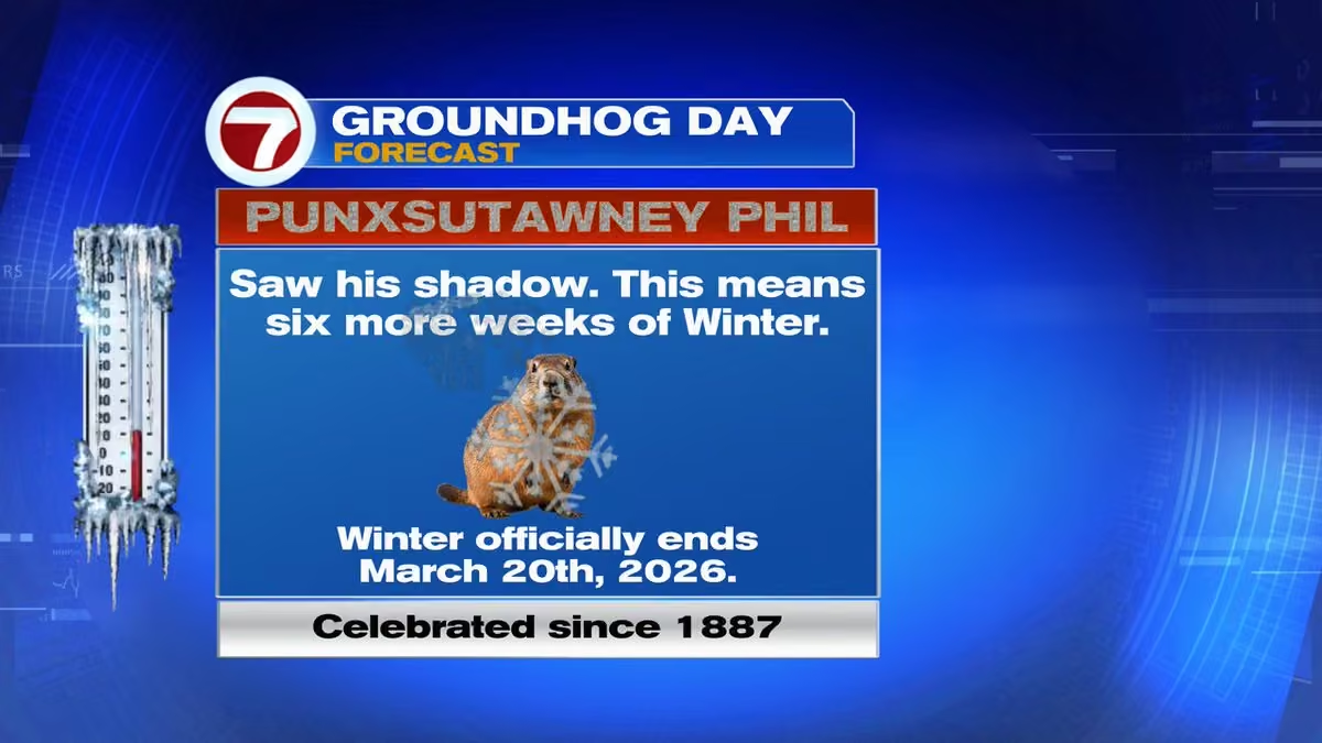 Vivian Gonzalez
@VivianGonzalez7
Temperatures in the 40's to around 50 degrees in the Florida Keys. @wsvn @abcmiami18 #flwx @7weather
 Vivian Gonzalez
@VivianGonzalez7
Low 30's for portions of Southern Miami-Dade. @wsvn @abcmiami18 #flwx @7weather
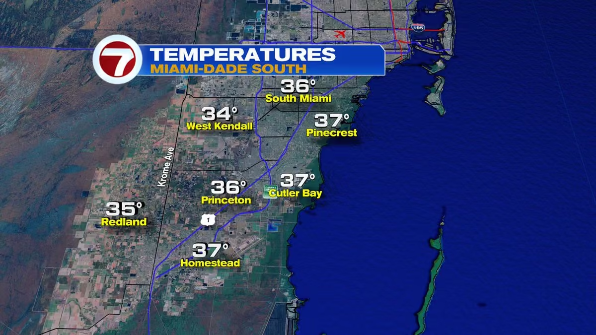 Vivian Gonzalez
@VivianGonzalez7
Widespread 30's to start in Northern Miami-Dade. @wsvn @abcmiami18 #flwx @7weather
 Vivian Gonzalez
@VivianGonzalez7
Very cold in the 30's to start in Broward County. @wsvn @abcmiami18 #flwx @7weather
 Vivian Gonzalez
@VivianGonzalez7
Freeze warning for metro and inland Broward and Miami-Dade until 9am.
Cold Weather Advisory for Broward, Miami-Dade and upper Florida Keys until 10am. @wsvn @abcmiami18 #flwx @7weather
 Vivian Gonzalez
@VivianGonzalez7
Feels like temperatures are freezing. It feels like 29 in West Kendall and 30 degrees in Hialeah. Don't forget to dress in layers South #florida. @wsvn @7weather @abcmiami18 #flwx
 Vivian Gonzalez
@VivianGonzalez7
Winter in South #florida.
Iguanas will be brumating for a few days here in Davie.
@wsvn @ABCMiami18 @7Weather #flwx

Vivian Gonzalez reposted
Jackson Dill
@Jackson_Dill
⚠️ COLD WEATHER ADVISORY in effect for metro and coastal Miami-Dade and Broward for wind chills in the low to mid 20s Saturday night into Sunday morning

Vivian Gonzalez reposted
Jackson Dill
@Jackson_Dill
⚠️ FREEZE WARNING now in effect for inland Miami-Dade and Broward for likely freezing temps Saturday night into Sunday morning
 Vivian Gonzalez
@VivianGonzalez7
On record watch Sunday with widespread 30's for Broward and Miami-Dade. @wsvn @abcmiami18 #flwx @7weather
 Vivian Gonzalez
@VivianGonzalez7
Protect people, pets & plants. Also, we don't normally get freezing temps. (32F or lower) & pipes can freeze, burst or crack. Take proper precautions. Good tip is to disconnect & drain garden hoses to prevent water from freezing back into the pipes. @wsvn @abcmiami18 #flwx
 Vivian Gonzalez
@VivianGonzalez7
Clouds on the increase today with showers possible. It should start clearing by tonight. @wsvn @7weather @abcmiami18 #flwx
Vivian Gonzalez
@VivianGonzalez7
An Extreme Cold Watch is in place for Palm Beach County. This means wind chills could feel like the teens to 20's by Sunday morning. #flwx @7weather @wsvn @abcmiami18
 Vivian Gonzalez
@VivianGonzalez7
FREEZE WATCH is in effect for Broward & Miami-Dade Counties, from West of Krome in Dade & west of US27 & the Sawgrass in Broward. Stay with @WSVN & @ABCMiami18 for the latest. #flwx @7weather
 Vivian Gonzalez
@VivianGonzalez7
GALE WATCH going into effect Saturday through Sunday afternoon for strong winds. Dangerous marine conditions expected. @wsvn @abcmiami18 #flwx @7weather
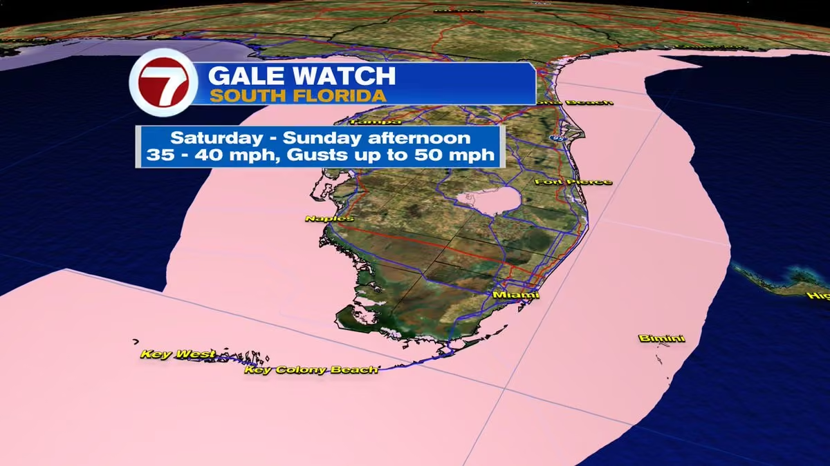 Vivian Gonzalez
@VivianGonzalez7
The wind will make temperatures feel freezing Sunday morning. Feels like temperatures will be in the 20's across Broward and Miami-Dade. Upper 30's to low 40's from the upper to middle #florida Keys. @wsvn @abcmiami18 #flwx @7weather
Vivian Gonzalez
@VivianGonzalez7
Forecast lows on Sunday are in the widespread 30's for mainland South Florida. Some records will be in jeopardy! @wsvn @abcmiami18 #flwx @7weather
 Vivian Gonzalez
@VivianGonzalez7
This is how we woke up this morning. @wsvn @wsvn #flwx @7weather
 Vivian Gonzalez
@VivianGonzalez7
If you think the 40's & 50's is cold for South #florida, wait until the weekend. Temperatures are forecast to be EXTREMELY COLD ON SUNDAY. Forecast calls for the 30's in Broward & Miami-Dade. In Miami, the 116 year old record for the day of 36 degrees will be in jeopardy! @wsvn
 Vivian Gonzalez
@VivianGonzalez7
CHILLY START- Bundle up South Florida! @WSVN @ABCMIAMI18 #flwx @7WEATHER
 Vivian Gonzalez
@VivianGonzalez7
The fog is more dense in Southern Miami-Dade. @wsvn @abcmiami18 #flwx @7weather
 Vivian Gonzalez
@VivianGonzalez7
Some fog this morning in Downtown Miami. @wsvn @abcmiami18 #flwx @7weather
 Vivian Gonzalez
@VivianGonzalez7
A small wrinkle in the atmosphere offshore will leave South Florida with a chance of seeing showers this afternoon, but it should be drier & warmer overall. However, millions are under cold weather alerts from the Southern Rockies to New England ahead of a major winter storm.
Vivian Gonzalez
@VivianGonzalez7
It is cloudy and rainy in some areas. Get all the details on Today in Florida! @wsvn @abcmiami18 #flwx @7weather
Vivian Gonzalez
@VivianGonzalez7
NOT AS COLD- This is how we woke up! @wsvn @abcmiami18 #flwx @7weather
 Vivian Gonzalez
@VivianGonzalez7
If you are tailgating outside @HardRockStadium for the big game, make sure to dress in layers to stay comfortable. Look for bright sun & mild high temps. in the upper 60's, but it will cool down more throughout the game with a gusty breeze out of the N/NE. @wsvn @abcmiami18
 Vivian Gonzalez
@VivianGonzalez7
This is how we woke on Martin Luther King Jr. Day! @wsvn @abcmiami18 #flwx
 Vivian Gonzalez
@VivianGonzalez7
This is how we woke up! @wsvn @7weather #flwx @abcmiami18
 Vivian Gonzalez
@VivianGonzalez7
FRIGID IN SOUTH FLORIDA- A lot of areas feeling like the 30's. @wsvn @7weather #flwx @abcmiami18
 Vivian Gonzalez
@VivianGonzalez7
COLD WEATHER ALERTS in #florida. Temperatures are currently in the 20's for Northern parts. @wsvn @7weather #flwx @abcmiami18
 Vivian Gonzalez
@VivianGonzalez7
It is feeling like the 30's in Kendall and Homestead. @wsvn @7weather #flwx @abcmiami18
 Vivian Gonzalez
@VivianGonzalez7
The Redlands in the upper 30's! @wsvn @7weather #flwx @abcmiami18
 Vivian Gonzalez
@VivianGonzalez7
In the low to mid 40's in Northern Miami-Dade. @wsvn @7weather #flwx @abcmiami18
 Vivian Gonzalez
@VivianGonzalez7
Widespread low 40's now in Broward. @wsvn @7weather #flwx @abcmiami18
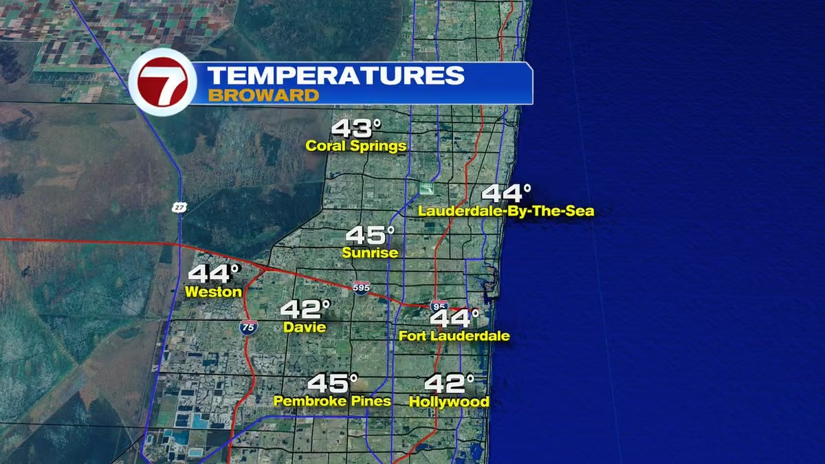 Vivian Gonzalez
@VivianGonzalez7
FRIGID FRIDAY- A cold start for South #florida in the 40's with some 50's in the Florida Keys. However, temperatures are expected to continue falling before sunrise. Wind chills are already in the 30's. Make sure to dress in layers & get the latest on @wsvn & @abcmiami18 at 5am!
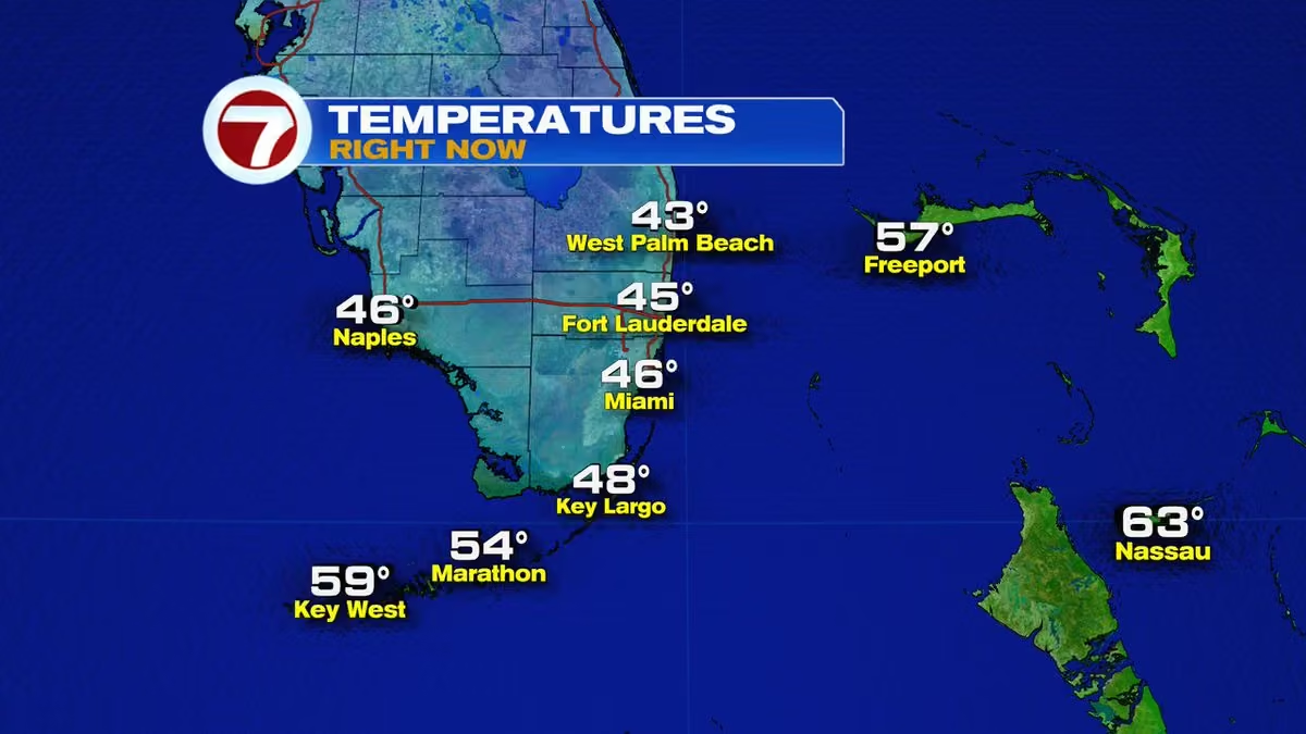 Vivian Gonzalez
@VivianGonzalez7
*UPDATE* COLD WEATHER ADVISORY EXTENDED to included extreme Southern Miami-Dade. CANCELLED for Coast Broward. This means Metro and inland areas remain under the advisory for feels like temperatures dropping potentially as low as 30 degrees. @wsvn @abcmiami18 #flwx
 Vivian Gonzalez
@VivianGonzalez7
Here are your headlines for today: @wsvn @abcmiami18 #flwx
 Vivian Gonzalez
@VivianGonzalez7
It will be very gusty this afternoon after 3pm. Gusts over 30 mph possible once the front crosses through. @wsvn @abcmiami18 #flwx
 Vivian Gonzalez
@VivianGonzalez7
FREEZE WARNINGS in effect for several counties in #florida. @wsvn @abcmiami18 #flwx
 Vivian Gonzalez
@VivianGonzalez7
Rain now entering West Broward and it will be moving quickly through the area. @wsvn @abcmiami18 #flwx
Vivian Gonzalez
@VivianGonzalez7
There is moisture ahead a strong cold front. It should start to move in between 7-8am and there will be a rain chance at least through early afternoon until winds turn out of the North & gusty to dry conditions out. Temperatures tumble drastically tonight. @WSVN #flwx @ABCMIAMI18
Vivian Gonzalez
@VivianGonzalez7
*JUST IN* COLD WEATHER ADVISORY issued for Broward and Miami-Dade. It goes into effect Friday from 3am to 9am for very cold wind chills as low as 30 degrees expected for most of South #florida. This can lead to hypothermia with prolonged exposure. @wsvn #flwx @abcmiami18
 Vivian Gonzalez
@VivianGonzalez7
Cold air on the way. Friday morning most areas will be in the 40's with a few 50's in the Florida Keys. Feels like temperatures for Broward & Miami-Dade will be in the 30's due to the stronger North wind. Some models even calling for lows possibly getting into the 30's. #flwx
Vivian Gonzalez
@VivianGonzalez7
*JUST IN* DENSE FOG ADVISORY EXTENDED until 9am. It is struggling to clear. Use extra caution while driving this morning. @wsvn #flwx @abcmiami18
 Vivian Gonzalez
@VivianGonzalez7
FOG becoming more dense across Broward and Miami-Dade. @wsvn #flwx @abcmiami18
 Vivian Gonzalez
@VivianGonzalez7
Visibility is looking good in North Bay Village facing Downtown Miami. @wsvn #flwx @abcmiami18
 Vivian Gonzalez
@VivianGonzalez7
FOGGY START in Downtown Ft. Lauderdale. @wsvn @abcmiami18 #flwx
 Vivian Gonzalez
@VivianGonzalez7
FREEZE WATCH in effect for a good portion of #florida. This means temperatures could drop below freezing (32F) & get cold enough for water to turn to ice. This could affect people, crops, pipes and create slippery roads. @wsvn @abcmiami18 #flwx
 Vivian Gonzalez
@VivianGonzalez7
SHOWERS & ISOLATED STORMS DEVELOPING near the lower Florida Keys. This is forecast to grow and move in our general direction. Right now it is BETTER, but it will turn WETTER especially around coastal areas today. @wsvn @abcmiami18 #flwx
Vivian Gonzalez
@VivianGonzalez7
Visibility is going down for inland locations. It is looking good along the coast. @wsvn @abcmiami18 #flwx
 Vivian Gonzalez
@VivianGonzalez7
DENSE FOG ADVISORY in effect through 8am for parts of Broward and Miami-Dade until 8am. @WSVN #flwx @ABCMIAMI18
 Vivian Gonzalez
@VivianGonzalez7
Soggy start across portions of South Florida with the best chance of seeing showers along coastal communities. There will be some dry time, but it will be a gloomy looking day with highs in the mid to upper 70's. A few showers possible tonight as well. @wsvn @abcmiami18 #flwx
Vivian Gonzalez
@VivianGonzalez7
A series of fronts will keep South Florida unsettled. Look for mostly cloudy skies and chance of showers through Wednesday. Best chance is Wednesday night into Thursday morning with a stronger cold front moving in. @wsvn @abcmiami18 #flwx
Vivian Gonzalez
@VivianGonzalez7
A front is crossing through South Florida leaving a chance of showers this morning. Most of the shower activity right now is in Miami-Dade. @wsvn @abcmiami18 #flwx
Vivian Gonzalez
@VivianGonzalez7
DENSE FOG ADVISORY issued for inland Broward and will run through 9am. Use extra caution while driving through this area. @wsvn @abcmiami18 #flwx
 Vivian Gonzalez
@VivianGonzalez7
FOG ADVISORY EXTENDED until 10am. @wsvn #flwx @abcmiami18
 Vivian Gonzalez
@VivianGonzalez7
High pressure in the upper levels is expanding across the Southeast and that will keep conditions bright and dry most of the week with warmer than average temperatures. @wsvn #flwx @abcmiami18
Vivian Gonzalez
@VivianGonzalez7
DENSE FOG ADVISORY was issued for interior Broward through 9am. @wsvn #flwx @abcmiami18
 Vivian Gonzalez
@VivianGonzalez7
A strong earthquake happened at 8:58am ET North-Northwest of Rancho Viejo, Guerrero, Mexico. This is a small community in the mountains near Acapulco. It interrupted President Claudia Sheinbaum's first press conference of the year. @wsvn @abcmiami18 #wsvn #earthquake #news
 Vivian Gonzalez
@VivianGonzalez7
This is how we woke up! @wsvn @abcmiami18 #flwx
 Vivian Gonzalez
@VivianGonzalez7
Skies cleared overnight in Key West, so now temperatures are in the widespread 50's across the island chain. @wsvn @abcmiami18 #flwx
 Vivian Gonzalez
@VivianGonzalez7
Southern Miami-Dade is in the low 40's. @wsvn @abcmiami18 #flwx
 Vivian Gonzalez
@VivianGonzalez7
Northern Miami-Dade has a mix of 40's and 50's. @wsvn @7weather @abcmiami18 #flwx
 Vivian Gonzalez
@VivianGonzalez7
Most areas in Broward are in the 40's this morning. @wsvn @abcmiami18 #flwx
 Vivian Gonzalez
@VivianGonzalez7
This is how we woke up! @WSVN @ABCMIAMI18 #flwx #cold
 Vivian Gonzalez
@VivianGonzalez7
HAPPY NEW YEAR! Look for plenty of sunshine with highs once again in the mid to upper 60's. @wsvn @abcmiami18 #flwx
 Vivian Gonzalez
@VivianGonzalez7
The areas highlighted in blue are under a Frost Advisory. However, temperatures are a touch colder than yesterday, so patchy frost is possible over inland/rural areas of Broward and Miami-Dade. @WSVN @ABCMIAMI18 #flwx
 Vivian Gonzalez
@VivianGonzalez7
The Redlands is at 36 degrees right now. Please bundle up South Florida. It is a could start to the year! @wsvn @abcmiami18 #flwx
 Vivian Gonzalez
@VivianGonzalez7
Davie is down to 39 degrees on this first day of 2026. Temperatures could drop a few more degrees before sunrise. @WSVN @ABCMIAMI18 #flwx
 Vivian Gonzalez
@VivianGonzalez7
This is how we woke up @wsvn @abcmiami18 #flwx
 Vivian Gonzalez
@VivianGonzalez7
Tomorrow morning could be colder with some areas around inland Broward and Miami-Dade dropping into the upper 30's. Patchy frost possible West of Homestead. @wsvn @abcmiami18 #flwx #cold #brr
Vivian Gonzalez
@VivianGonzalez7
Make sure to dress in layers, protect your pets and be careful if using space heaters. @WSVN @ABCMIAMI18 #flwx
 Vivian Gonzalez
@VivianGonzalez7
It feels like 38 degrees in West Kendall when you factor the brisk breeze! @wsvn #flwx @abcmiami18 #cold #brr
 Vivian Gonzalez
@VivianGonzalez7
The Florida Keys are mostly in the 50's. @wsvn @abcmiami18 #flwx
 Vivian Gonzalez
@VivianGonzalez7
Coldest location is the Redlands at 42 degrees. @wsvn @abcmiami18 #flwx
 Vivian Gonzalez
@VivianGonzalez7
Upper 40's now in Northern Miami-Dade. @wsvn @abcmiami18 #flwx
 Vivian Gonzalez
@VivianGonzalez7
Widespread 40's in Broward. Bundle up! @wsvn #flwx @abcmiami18
 Vivian Gonzalez
@VivianGonzalez7
I'm back and it is cold outside! Temperatures are in the 50's along the coast and 40's inland. They will continue to tumble before sunrise. Get the latest on @wsvn and @abcmiami18 starting at 5am! #flwx #cold
 Vivian Gonzalez
@VivianGonzalez7
The weekend will be feeling more comfortable with humidity levels going down. Another front could bring a few showers on Tuesday with winds building after it crosses through the area. Expect the holiday to be nice, breezy & above average. @wsvn @abcmiami18 #flwx
 Vivian Gonzalez
@VivianGonzalez7
We will be on record watch today! @wsvn #flwx @abcmiami18
 Vivian Gonzalez
@VivianGonzalez7
Live outside our studio in North Bay Village you can see the clouds and white caps due to the rain and wind near the coast... Beach and boating not advised. @WSVN @ABCMIAMI18 #flwx
 Vivian Gonzalez
@VivianGonzalez7
COASTAL CONCERNS for a good portion of the week due to strong winds. @wsvn @abcmiami18 #flwx
 Vivian Gonzalez
@VivianGonzalez7
HIGH SURF ADVISORY in effect through 7pm for Coastal Broward for large breaking waves of 1 to 10 feet expected in the surf zone. @wsvn @abcmiami18 #flwx
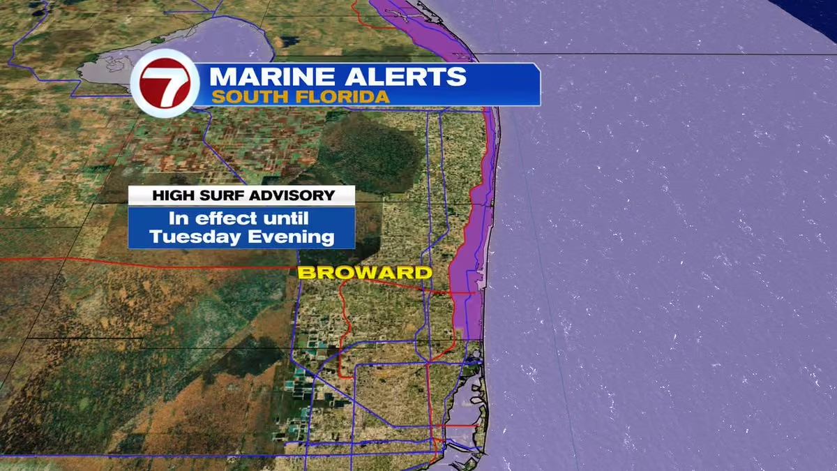 Vivian Gonzalez
@VivianGonzalez7
WIND ADIVOSRY in effect for Coastal Broward and Miami- Dade until 7pm tonight. Sustained winds out of the Northeast between 20-25 mph with gusts up to 35 mph possible. Use extra caution while driving today! @wsvn @abcmiami18 #flwx
 Vivian Gonzalez
@VivianGonzalez7
Coastal showers clipping Miami Beach. Lightning located to the East. @wsvn #flwx @abcmiami18
Vivian Gonzalez
@VivianGonzalez7
The Seminole Hard Rock @WinterfestInc Boat Parade is happening Saturday night in @FTLCityNews. It will be nice with a mix of sun & clouds & comfortably warm highs in the upper 70's. As the parade starts at 6pm, temps. in the mid 70's. Mainly dry night! @wsvn @abcmiami18 #flwx
 Vivian Gonzalez
@VivianGonzalez7
In the Florida Keys temperatures are in the 60's to about 70 degrees in some spots. @wsvn @abcmiami18 #flwx
 Vivian Gonzalez
@VivianGonzalez7
Temperatures in the 50's in Southern Miami-Dade. @wsvn @abcmiami18 #flwx
 Vivian Gonzalez
@VivianGonzalez7
Temperatures in Northern Miami-Dade right now. @wsvn @abcmiami18 #flwx
 Vivian Gonzalez
@VivianGonzalez7
Temperatures right now in Broward. Don't forget to wear a sweater or jacket! @wsvn @abcmiami18 #flwx
 Vivian Gonzalez
@VivianGonzalez7
Few showers have popped up around Key Biscayne and the upper Florida Keys. Still a chance of seeing a few showers until stalled front pushes away later today. @wsvn @abcmiami18 #flwx
Vivian Gonzalez
@VivianGonzalez7
CLOUDY CONDITIONS today with a chance of a few showers. Temperatures will be noticeably cooler than yesterday. Highs were in the upper 80's and today in the mid to upper 70's. @WSVN @ABCMIAMI18 #flwx
Vivian Gonzalez
@VivianGonzalez7
2 fronts- First one this morning & second this afternoon. Ahead look for some showers & maybe even an isolated storm as they cross through. Clouds set to linger tonight with a northerly wind building in. Hopefully more comfortable & drier throughout the day Tuesday. @wsvn #flwx
Vivian Gonzalez
@VivianGonzalez7
Two records tied yesterday. It was very warm in Miami and Fort Lauderdale. @wsvn @abcmiami18 #flwx
 Vivian Gonzalez
@VivianGonzalez7
Near record warmth possible in Miami and Ft. Lauderdale ahead of a front. @ABCMIAMI18 @WSVN #flwx
 Vivian Gonzalez
@VivianGonzalez7
Miami is the warmest spot in the country! @wsvn @abcmiami18 #flwx
 Vivian Gonzalez
@VivianGonzalez7
Another front approaches from the North and winds will be switching out of the South-Southwest on Tuesday. This could help temperatures in some areas near records. Ahead and along the front it should be dry. Nice conditions with near average temperatures return mid-week. @wsvn
 Vivian Gonzalez
@VivianGonzalez7
Patchy inland fog forming this morning due to clearing skies, higher humidity and light winds. Visibility dropping in Hialeah. @wsvn @abcmiami18 #flwx
 Vivian Gonzalez
@VivianGonzalez7
It is turning gusty now across South Florida. Gusts could be up to 30 mph this afternoon. Rough marine conditions expected to continue through Sunday. @wsvn @abcmiami18 #flwx
 Vivian Gonzalez
@VivianGonzalez7
Marine hazards in place today due to the wind that will be windy to gusty at times. @wsvn @abcmiami18 #flwx
 Vivian Gonzalez
@VivianGonzalez7
We had a quick cooldown and now it is much warmer to start than yesterday. @wsvn @abcmiami18 #flwx
 Vivian Gonzalez
@VivianGonzalez7
Tomorrow is the last day of the 2025 Atlantic Hurricane Season and it quiet out there! @wsvn @abcmiami18 #flwx
 Vivian Gonzalez
@VivianGonzalez7
HAPPY SATURDAY! Temperatures are not as cool as yesterday, but some areas in West Miami-Dade are in the upper 50's. It is considerably warmer along coastal communities. @WSVN @ABCMIAMI18 #flwx
 Vivian Gonzalez
@VivianGonzalez7
Here is your holiday countdown!
#happyholidays @wsvn #flwx @abcmiami
 Vivian Gonzalez
@VivianGonzalez7
It is looking like a warm Thanksgiving here in South Florida. If you are planning ahead, a few showers could impact the region around our local waters & the East coast Thursday & Friday as a front will remain just to the North. Highs forecast in the low 80's. @wsvn #flwx
 Vivian Gonzalez
@VivianGonzalez7
High pressure will keep conditions dry and pleasantly warm this weekend with plenty of sunshine. Heading into next week, a weak front nearby will increase the possibility of seeing an isolated shower, but it won't be until Thanksgiving day that we will have a better chance.
 Vivian Gonzalez
@VivianGonzalez7
High pressure remains in charge and blocking a system that will stay to the North producing scattered storms and widespread showers from the Texas coast to the central Appalachians today. Slight changes happen next week for South Florida. @WSVN #flwx
Vivian Gonzalez
@VivianGonzalez7
High pressure will dominate over the next few days leaving conditions quiet & temperatures running slightly above average. No active weather for South Florida likely through the weekend. @wsvn @abcmiami18 #flwx
Vivian Gonzalez
@VivianGonzalez7
This is how we woke up. There was a considerable different between inland and coastal locations. @WSVN @ABCMIAMI18 #flwx
 Vivian Gonzalez
@VivianGonzalez7
This morning was comfortably cool for some! @wsvn @abcmiami18 #flwx
 Vivian Gonzalez
@VivianGonzalez7
How we woke up this morning! @wsvn #flwx @abcmiami
 Vivian Gonzalez
@VivianGonzalez7
Temperatures are in the mid to upper 60's in the Florida Keys. @wsvn #flwx @abcmiami18
 Vivian Gonzalez
@VivianGonzalez7
Currently 59 in Kendall & South Miami! @wsvn #flwx @abcmiami18
 Vivian Gonzalez
@VivianGonzalez7
Cool as well in Northern Miami-Dade. @wsvn #flwx @abcmiami18
 Vivian Gonzalez
@VivianGonzalez7
Temperatures right now in Broward are on the cool side! @wsvn #flwx @abcmiami18
 Vivian Gonzalez
@VivianGonzalez7
Woke up to another cool start. Some areas were in the 50's! @wsvn @abcmiami18 @flwx
 Vivian Gonzalez
@VivianGonzalez7
Cloud cover and winds are increasing for today. Overall, it should be mainly dry with comfortable air in place. @wsvn @abcmiami18 #flwx
Vivian Gonzalez
@VivianGonzalez7
A weak front is set to arrive this afternoon. Look for mostly dry conditions with only a few occasional showers possible at times. Hazardous seas will begin for the Atlantic around midday today and continue through Tuesday night. @WSVN @ABCMIAMI18 #flwx
Vivian Gonzalez
@VivianGonzalez7
This is how we woke up this morning! @wsvn @abcmiami18 #wsvn #flwx
 Vivian Gonzalez
@VivianGonzalez7
COOL START- Cool-ish start around mainland South Florida in the upper 50's to mid 60's. Florida Keys mild in the low 70's. @wsvn @abcmiami18 #wsvn
 Vivian Gonzalez
@VivianGonzalez7
FRIDAY 5AM ADVISORY & CONE- Hurricane #melissa is quickly away from Bermuda and will likely lose tropical characteristics later today. @WSVN #wsvn @ABCMIAMI18
 Vivian Gonzalez
@VivianGonzalez7
Halloween promises to be a real treat tomorrow. Cool to start and comfortable for trick-or-treating! @WSVN @ABCMIAMI18
 Vivian Gonzalez
@VivianGonzalez7
THURSDAY 8AM ADVISORY- #melissa is still a strong Category 2 hurricane. It will be approaching Bermuda later today and tonight. @wsvn @abcmiami18 #wsvn
 Vivian Gonzalez
@VivianGonzalez7
Gusty winds out of the Northwest now around South Florida due a fall front that has moved through the region. @wsvn #flwx
 Vivian Gonzalez
@VivianGonzalez7
Conditions are improving in the #bahamas. There are some periods of heavy rain & gusty winds for Central & Southeastern portions. Well to the East into South #florida you can see a broken line of rain showers associated with a front protecting us & providing for a gusty breeze.
Vivian Gonzalez
@VivianGonzalez7
THURSDAY 5AM CONE- Hurricane #melissa is expected to pass to the northwest of Bermuda later today and tonight. Hurricane Warning in effect for Bermuda. @wsvn @abcmiami18 #wsvn
 Vivian Gonzalez
@VivianGonzalez7
THURSDAY 5AM ADVISORY- Hurricane #melissa is a Category 2 system starting to move away quickly from the Central Bahamas this morning. Watches and warnings have been lifted for the #bahamas. @wsvn @abcmiami18 #wsvn
Vivian Gonzalez reposted
Vivian Gonzalez reposted
Vivian Gonzalez reposted
 Robert St.ElizabethNative
@DaRealBigDon
Black River is gone!!!
What am I really seeing here?
#hurricane #melissa
Vivian Gonzalez reposted
 Giovanni R. Dennis
@GiovanniRDennis
St. Elizabeth this morning.
The aftermath.
#trackingmelissa #hurricanemelissa #jamaica @CVMTV
Vivian Gonzalez
@VivianGonzalez7
Tropical storm-force wind gusts already reaching the Central or Southeastern Bahamas. Ragged Island reporting a wind gust of 55mph. @wsvn @abcmiami18 #wsvn
Vivian Gonzalez
@VivianGonzalez7
A stronger front moves in on Thursday and that one will bring drier and cooler air for #halloween. Lows on Friday will be in the low 60's with highs in the upper 70's, so look for comfortable conditions for trick-or-treating. @wsvn @abcmiami18 #wsvn
Vivian Gonzalez
@VivianGonzalez7
WEDNESDAY 8AM CONE CLOSE-UP- #melissa will be moving through the Central or Southeastern #bahamas this afternoon. Tropical storm conditions are already spreading through the area. @wsvn @abcmiami18
 Vivian Gonzalez
@VivianGonzalez7
ISLAND IMPACTS from #melissa continue today. @WSVN @ABCMIAMI18 #wsvn
Vivian Gonzalez
@VivianGonzalez7
WEDNESDAY 8AM ADVISORY- #melissa is now a Cat 2 and still moving over Eastern Cuba. It is forecast to emerge into the Southwestern Atlantic soon. @wsvn @abcmiami18 #wsvn
 Vivian Gonzalez
@VivianGonzalez7
Major Hurricane #melissa is soaking Eastern Cuba & close to moving off the coast & approach the #bahamas. There is a hurricane-force wind gust in Holguin of 82 mph & up to tropical storm-force wind gusts already spreading into the portions of the Central & Southeastern Bahamas.
Vivian Gonzalez
@VivianGonzalez7
WEDNESDAY 5AM CONE- #melissa is expected to cross Eastern Cuba this morning, move across the Southeastern or Central Bahamas later today, and pass near or to the West of Bermuda Thursday night. @wsvn @abcmiami18 #wsvn
 Vivian Gonzalez
@VivianGonzalez7
WEDNESDAY 5AM ADVISORY- #melissa is still a major hurricane bringing damaging winds, flooding rains, and dangerous storm surge as it moves through Eastern Cuba. @wsvn @abcmiami18 #wsvn
 Vivian Gonzalez
@VivianGonzalez7
NEW- Extremely dangerous Hurricane #melissa makes landfall in the Southern coast of Eastern Cuba. Landfall happened in the Cuban province of Santiago de Cuba near the city of Chivirico at 3:10am with winds of 120mph. @WSVN @ABCMIAMI18 #wsvn

Vivian Gonzalez reposted
Giovanni R. Dennis
@GiovanniRDennis
Cave valley, St Ann
House Submerged
#trackingmelissa #hurricanemelissa #jamaica @CVMTV

Vivian Gonzalez reposted
Giovanni R. Dennis
@GiovanniRDennis
#happeningnow
Alligator Pond, Manchester
#trackingmelissa #hurricanemelissa #jamaica @CVMTV
Vivian Gonzalez reposted
Vivian Gonzalez
@VivianGonzalez7
NEW- WATCHES & WARNINGS- Hurricane Warning is now in effect for the province of Las Tunas and a Tropical Storm Warning for the province of Camaguey. The Hurricane Watch for the Turks and Caicos Islands has been discontinued. @wsvn @abcmiami18
 Vivian Gonzalez
@VivianGonzalez7
TUESDAY 11AM ADVISORY & CONE- Cat 5 #melissa is about to make landfall in #jamaica. It is expected to reach Southeastern #cuba as a major hurricane Wednesday morning, & it will still be a strong hurricane when it moves across the Central/Southeastern #bahamas. @wsvn @abcmiami18
 Vivian Gonzalez
@VivianGonzalez7
NEW- TUESDAY 11AM ADVISORY- #melissa about to make landfall in #jamaica. It is moving North-Northeast slightly faster at 9 mph. New advisories have been issued for Cuba. @wsvn @abcmiami18
 Vivian Gonzalez
@VivianGonzalez7
A front is protecting us from #melissa. In fact, we are watching 2 fronts. The 1st one will cross through tonight leaving South Florida nice & less humid Wednesday. However, the 2nd front arrives Thursday & that one will bring drier & cooler air for #halloween. @wsvn @abcmiami18
Vivian Gonzalez
@VivianGonzalez7
Wind gusts over 110 mph currently in Black River. Winds set to increase as the center of #melissa nears the Southern coast of #jamaica. @wsvn @abcmiami18
 Vivian Gonzalez
@VivianGonzalez7
Catastrophic winds moving onshore Southern #jamaica. Category 5 #melissa will be making landfall soon. @wsvn @abcmiami18
Vivian Gonzalez
@VivianGonzalez7
NEW- TUESDAY 10AM UPDATE- #melissa is stronger. Pressure dropped to 892mb and winds are up to 185mph. #jamaica @wsvn @abcmiami18
 Vivian Gonzalez
@VivianGonzalez7
Hurricane Hunters continue showing pressure is dropping and sign that #melissa could be stronger. @wsvn @abcmiami18 #jamaica
Vivian Gonzalez
@VivianGonzalez7
NEW- TUESDAY 9AM UPDATE- Hurricane Hunters find #melissa stronger with pressure dropping to 896mb and winds up to 180mph. The eye of Melissa is nearing the southern coast of Jamaica and is expected to make landfall within the next few hours. @wsvn @abcmiami18
 Vivian Gonzalez
@VivianGonzalez7
Hurricane Hunters arriving to the center of Category 5 #melissa. More details to come with the 11am update. @wsvn @abcmiami18
Vivian Gonzalez
@VivianGonzalez7
TUESDAY 8AM ADVISORY- The eye of extremely dangerous Category 5 #melissa is approaching Western #jamaica. It is starting to pick up forward speed moving North-Northeast at 7 mph. @wsvn @abcmiami18
 Vivian Gonzalez
@VivianGonzalez7
Hurricane #melissa is a monster Category 5. #jamaica bracing for impact later this morning. Total structural failure is possible near the path of Melissa’s center. @wsvn @abcmiami18
Vivian Gonzalez
@VivianGonzalez7
Hurricane conditions have made it to #jamaica. Sustained winds of 78 mph being clocked Black River with a gust of 101 mph. @wsvn @abcmiami18
Vivian Gonzalez
@VivianGonzalez7
Hurricane-force wind gusts impacting #jamaica. Catastrophic flash flooding, landslides, and destructive winds will continue through today, causing widespread infrastructure damage, power and communication outages, and isolated communities. @wsvn @abcmiami18
Vivian Gonzalez
@VivianGonzalez7
TUESDAY 5AM CONE- #melissa is expected to move over Jamaica today, across southeastern Cuba Wednesday morning, and across the southeastern or central Bahamas later on Wednesday. @WSVN @ABCMIAMI18
 Vivian Gonzalez
@VivianGonzalez7
TUESDAY 5AM ADVISORY- Conditions are deteriorating on Jamaica as extremely dangerous Category 5 #melissa slowly approaches #jamaica. @wsvn @abcmiami18

Vivian Gonzalez reposted
Dylan Federico
@DylanFedericoWX
11AM ADVISORY: Melissa is now a catastrophic Category 5 hurricane with 165 MPH winds. Pressure of 908mb ties it with Hurricane Maria for the 10th lowest pressure on record in the Atlantic Basin. A historic hurricane strike is forecast in Jamaica tomorrow.
 Vivian Gonzalez
@VivianGonzalez7
FALL-LIKE WEATHER- South FL look for sct'd PM storms today ahead of Front #1 passing through Tuesday. It should be less humid midweek. Front #2 moves in Thursday & that one should provide for cooler conditions. Lows Friday AM (Halloween) in low 60's & highs in the upper 70's!
Vivian Gonzalez
@VivianGonzalez7
Hurricane Melissa's eye is about 11.5 miles wide. Destructive winds and catastrophic flooding expected in Jamaica. @wsvn @abcmiami18
Vivian Gonzalez
@VivianGonzalez7
MONDAY 8AM ADVISORY- NOAA & Air Force Reserve Hurricane Hunters are investigating #melissa and the pressure continues to drop. Some additional strengthening still possible today. @WSVN @ABCMIAMI18
Vivian Gonzalez
@VivianGonzalez7
MONDAY 5AM CONE- On the forecast track, Hurricane #melissa is expected to move near or over Jamaica tonight and Tuesday, across southeastern Cuba Tuesday night, and across the southeastern Bahamas on Wednesday. @wsvn @abcmiami18
 Vivian Gonzalez
@VivianGonzalez7
NEW- WATCHES AND WARNINGS- Hurricane Watch has been issued for the Central and Southeast Bahamas, including the Turks and Caicos Islands. @wsvn @abcmiami18
 Vivian Gonzalez
@VivianGonzalez7
NEW- MONDAY 5AM ADVISORY- #melissa is now a powerful Category 5 hurricane. @wsvn @abcmiami18

Vivian Gonzalez reposted
Vivian Gonzalez
@VivianGonzalez7
FRIDAY 8AM ADIVSORY & CONE- #melissa is now drifting to the East-Southeast. It is forecast to begin moving West over the weekend & become a hurricane. It will likely rapidly intensify into a major storm on Sunday. A pull to the North won't happen until the middle of next week.
 Vivian Gonzalez
@VivianGonzalez7
20th ANNIVERSARY- On this day, October 24 20 years ago Hurricane Wilma impacted Cozumel as a category 4 system & then it tracked to Southwest Florida due to a cold front. It made landfall with winds of 120 mph (Cat 3). @wsvn @abcmiami18 #flwx
Vivian Gonzalez
@VivianGonzalez7
WHY SO WINDY? There will be a large pressure difference taking place between high pressure settling in across the Southeast U.S. & a stalled front near South Florida. This normally funnels in stronger winds along the coast. @WSVN #flwx @ABCMIAMI18
 Vivian Gonzalez
@VivianGonzalez7
MARINE HAZARDS- Due to a gusty Northeast winds set to continue through the weekend, dangerous beach & boating conditions expected. Small craft advisories & rip current alerts are in effect. @wsvn #flwx @abcmiami18
 Vivian Gonzalez
@VivianGonzalez7
FRIDAY 5AM CONE- #melissa is nearly stationary, but a slow drift toward the northeast and north is expected later today and tonight. A westward drift is then forecast to begin on Saturday and continue through Monday. It is forecast to
become a major hurricane by Sunday. @wsvn
 Vivian Gonzalez
@VivianGonzalez7
FRIDAY 5AM ADVISORY- Tropical Storm #melissa is nearly stationary. Life-threatening and catastrophic flash flooding and landslides expected in portions of Southern Hispaniola and Jamaica through the weekend.
Vivian Gonzalez
@VivianGonzalez7
Join the Channel 7 Foundation & @AmericanCancer Society for the Making Strides Against Breast Cancer Walk this Saturday, October 25th at @AmernatArena & @LoanDepotPark. Looking at mostly sunny skies, temps. in the upper 70's & strong breeze. Get more details on @wsvn @abcmiami18.
 Vivian Gonzalez
@VivianGonzalez7
NEW WATCHES & WARNINGS due to #melissa- Jamaica under a Hurricane Watch and Tropical Storm Warning. @wsvn @abcmiami18
 Vivian Gonzalez
@VivianGonzalez7
THURSDAY 8AM ADVISORY- The government of Jamaica has issued a Hurricane Watch for the island, and has upgraded the Tropical Storm Watch to a warning. Life-threatening flooding expected across portions of Hispaniola and Jamaica through the weekend. @wsvn @abcmiami18
Vivian Gonzalez
@VivianGonzalez7
THURSDAY 5AM ADVISORY & CONE- #melissa continues to move slowly over the Central Caribbean. It is forecast to be nearer to Jamaica and the Southwestern portion of Haiti during the next couple of days. @wsvn #wsvn @abcmiami18
 Vivian Gonzalez
@VivianGonzalez7
THURSDAY 2AM ADVISORY- #melissa is crawling over the Central Caribbean. It is expected to bring heavy rains and life-threatening flooding to Hispaniola and Jamaica into the weekend. Slow strengthening into a hurricane will likely happening during the next few days. @wsvn
 Vivian Gonzalez
@VivianGonzalez7
WEDNESDAY 8AM ADVISORY- Recon finds Tropical Storm #melissa is moving very slowly. @wsvn @abcmiami18
 Vivian Gonzalez
@VivianGonzalez7
The risk of significant flash flooding and landslides possible across portions of Jamaica, Haiti and the Dominican Republic through the weekend. @wsvn @abcmiami18
 Vivian Gonzalez
@VivianGonzalez7
WATCHES & WARNINGS-
A Hurricane Watch is in effect for Southwestern peninsula of Haiti from the border with the Dominican Republic to Port-Au-Prince.
A Tropical Storm Watch is in effect for Jamaica. @WSVN @abcmiami18
 Vivian Gonzalez
@VivianGonzalez7
WEDNESDAY 5AM CONE- #melissa is expected to approach Jamaica and the Southwestern portion of Haiti later this week. Some gradual strengthening is anticipated during the next few days, and Melissa could become a hurricane on Thursday.
@wsvn @nbcmiami18
 Vivian Gonzalez
@VivianGonzalez7
WEDNESDAY 5AM ADVISORY- Tropical Storm #melissa has re-forms to the Northeast. Heavy rainfall and flooding expected over portions of Hispaniola and Jamaica. @wsvn @abcmiami18
 Vivian Gonzalez
@VivianGonzalez7
WEDNESDAY 2AM ADVISORY- Hurricane Hunter aircraft is currently investigating #melissa. More details to come at 5am. @wsvn @abcmiami18

Vivian Gonzalez reposted
Vivian Gonzalez
@VivianGonzalez7
TUE 11AM ADVISORY- The 13th named storm of the season forms over the Central Caribbean Sea. #melissa is expected to approach the southwestern portion of Haiti and Jamaica later this week. @wsvn @ABCMiami18
 Vivian Gonzalez
@VivianGonzalez7
TUE 11AM ADVISORY- #melissa is expected to bring heavy rains & risk of significant flooding & the danger of landslides to portions of Haiti & the Dominican Republic through the
weekend. A Hurricane Watch has been issued for the Southern coast & Tiburon peninsula of Haiti. @wsvn

Vivian Gonzalez reposted
National Hurricane Center
@NHC_Atlantic
NHC will initiate advisories on Tropical Storm Melissa (formerly AL98), located over the Caribbean Sea, at 1100 AM EDT (1500 UTC).
Vivian Gonzalez
@VivianGonzalez7
TUE 7:30AM TROPICS OUTLOOK- It appears that a well-defined center has developed & a tropical storm is expected to form later today over the Central Caribbean Sea. Interests in Puerto Rico, Hispaniola, Jamaica, & Cuba should monitor the progress of this system. @wsvn @abcmiami18
Vivian Gonzalez
@VivianGonzalez7
TUESDAY 2AM TROPICS OUTLOOK- Broad area of low pressure over the Central Caribbean Sea continues to organize, with winds near 45 mph, though it still lacks a well-defined center. A Tropical Storm (#melissa) is expected to form later today. @wsvn @abcmiami18
 Vivian Gonzalez
@VivianGonzalez7
Disturbance (INVEST 98L) in the Caribbean is going through an area of low wind shear and hot ocean temperatures. Conditions are favorable for a storm to form this week. The next name on the list: Melissa. @wsvn
Vivian Gonzalez
@VivianGonzalez7
Disturbance (INVEST 98L) in the Caribbean is going through an area of low wind shear and hot ocean temperatures. Conditions are favorable for a storm to form this week. The next name on the list: Melissa. @wsvn
Vivian Gonzalez
@VivianGonzalez7
WATCHING & WAITING- If disturbance develops quickly in the Central Caribbean, it will make an early Northward turn. If it develops slower, it gets stronger & makes late turn. Models still don't have a good handle on what will happen. Stay tuned to your Storm Team. @wsvn
Vivian Gonzalez
@VivianGonzalez7
Disturbance (INVEST 98l) in the Caribbean is moving West at 15-20mph & likely to slow down. This is when development will happen. Half of the models show it continuing to move West. The other half show it lifting North & impacting Hispaniola later this week. @wsvn
 Vivian Gonzalez
@VivianGonzalez7
MONDAY 8AM TROPICS OUTLOOK- Disturbance in the E. Caribbean is forecast to slow down while moving West. It is likely going to form into a Tropical Depression or Storm (#melissa) over the next few days. Conditions gradually improving across the Windward & Leeward Islands. @WSVN
 Vivian Gonzalez
@VivianGonzalez7
Fronts will not completely clear South Florida just yet, but at least will bring more comfortable air. A few showers possible today & Tuesday with a weak front nearby. By mid to late week, it should be drier with lower humidity & building breeze out of the Northeast. @wsvn #flwx
Vivian Gonzalez
@VivianGonzalez7
A weak front will be approaching today so winds will be on the increase with a chance of seeing coastal clouds and showers. It will be gusty at times on Friday and looking nice for the weekend. By early next week, another front could bump up rain chances. @WSVN #flwx
Vivian Gonzalez
@VivianGonzalez7
WEDNESDAY 5AM ADVISORY- Tropical Storm #lorenzo is forecast to dissipate on Thursday in the middle of the Atlantic. @wsvn @abcmiami18
 Vivian Gonzalez
@VivianGonzalez7
FALL FRONT on the move. A chance of a few showers ahead and along the front possible today. However, drier and less humid air will likely start filtering in tonight. @wsvn #flwx
Vivian Gonzalez
@VivianGonzalez7
SATURDAY 8AM TROPICS OUTLOOK- A tropical wave South of the Cape Verde Islands has a low chance to form during the next 7 days of the Central Tropical Atlantic. @wsvn
 Vivian Gonzalez
@VivianGonzalez7
SATURDAY 5AM ADVISORY & CONE- #jerry is moving North over the Atlantic. A Northward to North-Northeastward motion is expected through the weekend, followed by a turn toward the East on Monday. Gradual weakening is expected in the next few days. @wsvn
 Vivian Gonzalez
@VivianGonzalez7
STREET FLOOD ADVISORY in effect for a small portion of the middle Florida Keys until 11:15am. @wsvn #flwx
 Vivian Gonzalez
@VivianGonzalez7
It has been raining non-stop around the Florida Keys. Radar picking up possible rotation surrounding the island chain, so waterspouts are also possible. Please be weather aware with your Storm Team for the latest. @wsvn #flwx
Vivian Gonzalez
@VivianGonzalez7
FRIDAY 8AM ADVISORY- #jerry is moving North and away from the Leeward Islands. Flooding rains continue for the region. A Tropical Storm Warning is in effect for St. Barthelemy, St. Martin & Sint Maarten. @wsvn
 Vivian Gonzalez
@VivianGonzalez7
STREET FLOOD ADVISORY issued for parts of the Florida Keys through 9:15am. @wsvn #flwx
 Vivian Gonzalez
@VivianGonzalez7
WATCHES & WARNING due to #jerry. Tropical Storm Warning discontinued for Barbuda and Anguilla, as well as the Tropical Storm Watch for Antigua, St. Kitts, Nevis, Montserrat, Saba and St. Eustatius.. @wsvn
 Vivian Gonzalez
@VivianGonzalez7
FRIDAY 5AM ADVISORY & CONE- Subtropical Storm #karen continues moving Northeast over the Northern Atlantic. Should fall apart by tomorrow. @wsvn
 Vivian Gonzalez
@VivianGonzalez7
FRIDAY 5AM ADVISORY & CONE- Flash flood threat for the Leeward Islands continues as heavy rainfall from Jerry spreads across the region. #jerry will continue passing to the north of the Leeward Islands this morning, then move away from the islands later today. @wsvn
 Vivian Gonzalez
@VivianGonzalez7
THURSDAY 8AM ADVISORY- NOAA and Hurricane Hunters are currently investigating #jerry. @wsvn
 Vivian Gonzalez
@VivianGonzalez7
THURSDAY 8AM TROPICS OUTLOOK- Non-tropical low Northwest of the Azores has a low chance to form. @WSVN
 Vivian Gonzalez
@VivianGonzalez7
THURSDAY 5AM CONE- #jerry could become a hurricane by late Friday or Saturday and is expected to pass near or to the northeast of the northern Leeward Islands later today and tonight. @wsvn
 Vivian Gonzalez
@VivianGonzalez7
THURSDAY 5AM ADVISORY- #jerry is going to pass near the Northern Leeward Islands and Tropical Storm conditions possible later today into Friday. @wsvn
 Vivian Gonzalez
@VivianGonzalez7
WEDNESDAY 8AM ADVISORY- Hurricane Hunter aircraft is currently investigating #jerry. It is expected to be near or to the north of the northern Leeward Islands late Thursday and Friday.
@wsvn
 Vivian Gonzalez
@VivianGonzalez7
WEDNESDAY 5AM ADVISORY- #jerry is moving quickly and forecast to strengthen into a hurricane. A Tropical Storm Watch is in effect for the Northern Leeward Islands. @wsvn

Vivian Gonzalez reposted
Dylan Federico
@DylanFedericoWX
11AM ADVISORY: Tropical Storm Jerry has formed in the central tropical Atlantic. #jerry is forecast to become a hurricane later this week. Interests in the Leeward Islands and Bermuda need to closely monitor the progress of Jerry. Jerry does not pose a threat to South Florida.
 Vivian Gonzalez
@VivianGonzalez7
Double rainbow outside our studios in North Bay Village. @wsvn #flwx
 Vivian Gonzalez
@VivianGonzalez7
High tide underway in North Bay Village. Water level running high. Some areas of street flooding possible. @wsvn #flwx
 Vivian Gonzalez
@VivianGonzalez7
MONDAY 8AM TROPICS OUTLOOK- Broad low producing consistent storm activity. A tropical depression is likely to form within the next few days while it moves quickly across the central tropical Atlantic, approaching the northern Leeward Islands by the latter part of the week. @wsvn
 Vivian Gonzalez
@VivianGonzalez7
Today and tomorrow will feature the highest rain chances with breezy conditions along the coast. By the end of the week, we could be looking at the first Fall front moving in. If models are right, it will be drier and less humid for the weekend. Lets keep our fingers crossed.
 Vivian Gonzalez
@VivianGonzalez7
Southern Miami-Dade and Florida Keys continue to see rain and storms moving through. @wsvn #flwx
Vivian Gonzalez
@VivianGonzalez7
Forecast calling for a soggy several days especially for coastal communities. Better than 3 inches with higher amounts possible. @WSVN #flwx
Vivian Gonzalez
@VivianGonzalez7
Heavy rainfall possible along the East coast today. About 1 to 3 inches possible. Isolated amount of 4+ inches can't be ruled out. We have a marginal risk of seeing heavy rains causing areas of flooding. @wsvn #flwx
 Vivian Gonzalez
@VivianGonzalez7
Due to high rip current risk & King Tides flooding possible:
-Coastal Flood Statement for Broward & Miami-Dade through Sunday night
-Coastal Flood Statement for middle Florida Keys through Saturday morning
-Coastal Flood Advisory for upper Florida Keys through Saturday morning
Vivian Gonzalez
@VivianGonzalez7
FRIDAY 8AM TROPICS OUTLOOK- Low pressure has formed along a front over the Central Bahamas. It has a low chance to form as it meanders nearby. Regardless, heavy rains to spread into Florida and the Bahamas this weekend. @wsvn #flwx
 Vivian Gonzalez
@VivianGonzalez7
FRIDAY 8AM TROPICS OUTLOOK- Wave forecast to move off the coast of Africa now has a medium chance to form over the Central Tropical Atlantic over the next 7 days. @wsvn
 Vivian Gonzalez
@VivianGonzalez7
Here are updated rainfall totals from yesterday (6pm) through this morning (6am). Some areas received better than 3 to 6 inches of rain so far. @wsvn #flwx
 Vivian Gonzalez
@VivianGonzalez7
THURSDAY 8AM TROPICS OUTLOOK- A tropical wave will emerge off the West coast of Africa in a day or two and have a low chance to form over the Central Tropical Atlantic during the next 7 days. @wsvn
 Vivian Gonzalez
@VivianGonzalez7
THURSDAY 8AM TROPICS OUTLOOK- Low pressure could form near the NW Bahamas & South Florida along a stalled front by Saturday. Slow development possible as it moves across Florida and into the Gulf. @WSVN #flwx
 Vivian Gonzalez
@VivianGonzalez7
THURSDAY 8AM ADVISORY- Gusty winds continue over Bermuda as #imelda moves quickly away from the island. @wsvn
 Vivian Gonzalez
@VivianGonzalez7
Another King Tide cycle is coming up. However, there are already reports of street flooding around 10th avenue and 79th street causeway. @WSVN #flwx @NWSMIAMI
 Vivian Gonzalez
@VivianGonzalez7
THURSDAY 5AM ADVISORY- Hurricane #imelda is moving away quickly from Bermuda. The Hurricane Warning has been changed to a Tropical Storm Warning. Imelda should lose tropical characteristics later today. @wsvn
 Vivian Gonzalez
@VivianGonzalez7
WEDNESDAY 8AM ADVISORY- Hurricane Hunters currently investigating #imelda. @wsvn
 Vivian Gonzalez
@VivianGonzalez7
WEDNESDAY 5AM ADVISORY & CONE- Slight weakening as it loses tropical characteristics today, but #humberto is expected to still produce strong winds until it merges with a front tonight. @WSVN
 Vivian Gonzalez
@VivianGonzalez7
WEDNESDAY 5AM ADVISORY- #imelda forecast to produce hurricane-force winds, damaging waves and flash flooding to Bermuda later today. @wsvn
 Vivian Gonzalez
@VivianGonzalez7
TUESDAY 8AM ADVISORY- #imelda becomes the 4th hurricane of the season. @wsvn
 Vivian Gonzalez
@VivianGonzalez7
Today & tomorrow will be drier with a good amount of dry air filtering in from a NW flow across the region since South Florida sits on the outer edges of #imelda (moving away from the Bahamas). Outside of a brief & light shower, we will have breezy conditions & hotter temps.
Vivian Gonzalez
@VivianGonzalez7
Miami will be on record watch today! @wsvn #flwx
 Vivian Gonzalez
@VivianGonzalez7
TUESDAY 5AM CONE- #imelda forecast to move away from the Bahamas today and quickly be approaching Bermuda late on Wednesday as a hurricane. @wsvn
 Vivian Gonzalez
@VivianGonzalez7
TUESDAY 5AM ADVISORY & CONE- #humberto is slightly weaker, but still a hurricane. Dangerous surf and rip currents set to continue this week for Bermuda, Northern Caribbean, the Bahamas and U.S. East coast. @WSVN
 Vivian Gonzalez
@VivianGonzalez7
TUESDAY 5AM ADVISORY- #imelda a little stronger and likely to become a hurricane later today. Hurricane Watch in effect for Bermuda. @wsvn
 Vivian Gonzalez
@VivianGonzalez7
GUSTY SHOWERS moving through parts of Broward associated with the outer bands of #imelda (well away). Most areas will be dry today, but there is still a chance of seeing a sudden downpour today. @wsvn #flwx
Vivian Gonzalez
@VivianGonzalez7
MONDAY 8AM ADVISORY & CONE- #humberto a little stronger & expected to produce dangerous surf for Bermuda & most of the U.S. East coast this week. Tropical Storm Watch in effect for Bermuda. Tropical Storm conditions likely to reach the area tomorrow. @wsvn
 Vivian Gonzalez
@VivianGonzalez7
MONDAY 8AM ADVISORY- Tropical Storm #imelda continues moving Northward and a little stronger. Tropical Storm conditions impacting the Northwestern Bahamas. @wsvn
Vivian Gonzalez
@VivianGonzalez7
South Florida look for some sudden downpours today associated with #imelda located over 100 miles away (closest approach) from South Florida. Overall, look for plenty of steamy sunshine with gusty winds along the coast. Water woes likely through tomorrow. @wsvn
Vivian Gonzalez
@VivianGonzalez7
Tropical Storm-force wind gusts being experienced around parts of the Northwestern Bahamas. @wsvn
 Vivian Gonzalez
@VivianGonzalez7
MONDAY 5AM ADVISORY & CONE- Category 4 #humberto is expected to produce dangerous surf for Bermuda and most of the U.S. East coast this week. Tropical Storm conditions possible in Bermuda on Tuesday. @WSVN
 Vivian Gonzalez
@VivianGonzalez7
MONDAY 5AM CONE- #imelda is expected to turn sharply to the east-northeast Tuesday. On the forecast track, it is expected to move across the Northwestern Bahamas today & then turn east-northeastward, moving away from the southeastern U.S. by the middle part of this week. @wsvn
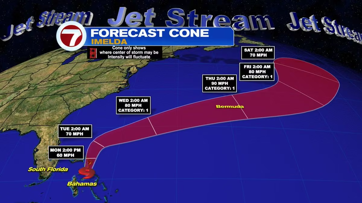 Vivian Gonzalez
@VivianGonzalez7
There is still a Tropical Storm Warning for parts of the Northwestern Bahamas due to #imelda. @wsvn
 Vivian Gonzalez
@VivianGonzalez7
MONDAY 5AM ADVISORY- #imelda is forecast to become a hurricane by Tuesday. Tropical Storm Warnings for the Bahamas have been discontinued. @wsvn

Vivian Gonzalez reposted
Phil Ferro
@PhilFerro7
NEW - Starting at 5 pm, NHC will begin issuing advisories on Potential Storm #9. This is former Invest 94L. Stats and track at 5 pm on-air and on-line.

Vivian Gonzalez reposted
National Hurricane Center
@NHC_Atlantic
NHC will initiate advisories on Potential Tropical Cyclone Nine (formerly AL94), located near eastern Cuba, at 500 PM EDT (2100 UTC).
Vivian Gonzalez reposted
National Hurricane Center
@NHC_Atlantic
2 pm EDT - A low pressure system #94l appears to be forming near eastern Cuba and the southeastern
Bahamas. Gradual development of this system is expected, and it will likely become a tropical
depression during the next day or so while it moves across the central and northwestern Bahamas. Tropical storm watches or warnings could be required for portions of the Bahamas and advisories on a potential tropical cyclone could be issued as early as later today. Visit hurricanes.gov for more.
 Vivian Gonzalez
@VivianGonzalez7
INVEST 94L could become a depression or storm (Imelda) later today near the Bahamas. Marine hazards are likely around our local waters starting late weekend. Right now, the breeze will build along the coast on Sunday. It is still forecast to turn North & East of South Florida.
Vivian Gonzalez
@VivianGonzalez7
FRIDAY 8AM ADVISORY & CONE- Center of #gabrielle is moving away from the Azores. Hurricane Warning has been discontinued. @wsvn
 Vivian Gonzalez
@VivianGonzalez7
FRIDAY 8AM TROPICS OUTLOOK- Invest 94L is showing signs of organization. An area of low pressure is expected to form along the wave by tonight when it moves near the SE Bahamas. It could become a tropical depression when it is in around the Central & NW Bahamas over the weekend.
 Vivian Gonzalez
@VivianGonzalez7
FRIDAY 5AM ADVISORY- Although #gabrielle lost tropical characteristics, it is producing hurricane-force wind gusts across the Central & Southeastern Azores. A few hours ago, Serra St. Barbera, located in the mountains on Terceira Island, reported a wind gust of 115 mph. @WSVN
 Vivian Gonzalez
@VivianGonzalez7
FRIDAY 5AM ADVISORY & CONE- #humberto becomes a hurricane. @wsvn
 Vivian Gonzalez
@VivianGonzalez7
THURSDAY 11AM ADVISORY & CONE- #humberto gaining strength. Expected to become a hurricane in a day or so over the Central Atlantic. @wsvn
 Vivian Gonzalez
@VivianGonzalez7
Disturbance (Invest 94L) is producing heavy rainfall and gusty winds from Dominican Republic and Haiti to Western Puerto Rick. Winds are up to 30 mph and it is now moving to the Northwest into the Southwestern Atlantic. @wsvn
Vivian Gonzalez
@VivianGonzalez7
THURSDAY 8AM ADVISORY- Hurricane #gabrielle will approach the Azores today and move across the island chain tonight into early Friday. It should lose tropical characteristics over the weekend. @wsvn
 Vivian Gonzalez
@VivianGonzalez7
THURSDAY 5AM ADVISORY & CONE- Hurricane #gabrielle is moving rapidly Eastward and should bring hurricane conditions to the Azores tonight or early Friday. @wsvn
 Vivian Gonzalez
@VivianGonzalez7
THURSDAY 5AM ADVISORY & CONE- Tropical Storm #humberto is forecast to strengthen in the coming days. For now there are no coastal watches and warnings in effect & it will pass well to the North of the Leeward Islands. @WSVN
 Vivian Gonzalez
@VivianGonzalez7
WEDNESDAY 11AM ADVISORY & CONE- #gabrielle slightly weaker, but still a hurricane. It is quickly moving East-Northeast. Hurricane Warning in effect for all the Azores. @wsvn
 Vivian Gonzalez
@VivianGonzalez7
We will be watching the tropics closely into the weekend. Invest 94 L could come close the U.S. However, it is too soon to tell whether there will be direct impact because it has not formed. Stay tuned to your Storm Team. @wsvn
 Vivian Gonzalez
@VivianGonzalez7
WEDNESDAY 8AM TROPICS OUTLOOK- Invest 94L is producing a large area of rain & gusty winds across the Virgin Islands & Puerto Rico. It should spread into the Dominican Rep. by tonight. As it slows down & enters the SW Atlantic, it could form near the Bahamas. @wsvn
 Vivian Gonzalez
@VivianGonzalez7
WEDNESDAY 8AM TROPICS OUTLOOK- Invest 93L is showing signs of organization. A Tropical Depression could form later today or Thursday. It will move well North of the islands. Bermuda should monitor closely. @wsvn
 Vivian Gonzalez
@VivianGonzalez7
WEDNESDAY 5AM ADVISORY & CONE- #gabrielle is going to approach the Azores during the day on Thursday. A Hurricane Warning has been issued. @wsvn
 Vivian Gonzalez
@VivianGonzalez7
Below are preliminary models on Invest 93L and Invest 94L. They are both likely to develop in the days ahead. However, their future is still yet unknown. Stay tuned to your Storm Team for the latest. @WSVN #93l #94l
 Vivian Gonzalez
@VivianGonzalez7
TUESDAY 8AM TROPICS OUTLOOK- A tropical wave (Invest 94L) is producing disorganized showers & gusty winds across much of the Windward & Leeward Islands. Rains forecast to spread into Puerto Rico & the Virgin Islands by tonight. As it slows down, it could form near the Bahamas.
 Vivian Gonzalez
@VivianGonzalez7
TUESDAY 8AM TROPICS OUTLOOK- A tropical wave less than 1000 miles East of the Lesser Antilles is showing signs of organization. It has now been designated Invest 93L and models show it could form by the latter part of this week. @wsvn
 Vivian Gonzalez
@VivianGonzalez7
TUESDAY 8AM TROPICS OUTLOOK- A tropical wave less than 1000 miles E of the Lesser Antilles is showing signs of organization. It has been designated Invest 93L. A Tropical Depression or Storm is likely to form by the latter part of the week. @WSVN
 Vivian Gonzalez
@VivianGonzalez7
TUESDAY 5AM ADVISORY- #gabrielle is powerful Cat 4 that will continue to move away from Bermuda today. The swells generated by Gabrielle will continue to affect Bermuda, the U.S. East Coast from North Carolina northward, and Atlantic Canada over the next few days. @WSVN
Vivian Gonzalez
@VivianGonzalez7
*SPECIAL UPDATE* MONDAY 9AM ADVISORY- #gabrielle rapidly intensifies into a major hurricane Southeast of Bermuda. @wsvn
 Vivian Gonzalez
@VivianGonzalez7
MONDAY 8AM TROPICS OUTLOOK- Tropical wave East of the Leeward Islands by the latter part of this week, is forecast to slow down & turn more northwestward, & a depression could form late this week when it is over the southwestern Atlantic or near the Bahamas. @wsvn
 Vivian Gonzalez
@VivianGonzalez7
MONDAY 8AM TROPICS OUTLOOK- Shower & storm activity associated with a tropical wave located about midway between the Lesser Antilles & the Cape Verde Islands has increased since yesterday. It now has a high chance to form. @wsvn
 Vivian Gonzalez
@VivianGonzalez7
MONDAY 5AM ADVISORY & CONE- #gabrielle is forecast to pass East of Bermuda tonight and could become a major hurricane. @wsvn
 Vivian Gonzalez
@VivianGonzalez7
Wonderful start on this Saturday at @StJude Walk Broward County! Chloe battled cancer & her story was truly inspiring. @wsvn @ABCMiami18


 Vivian Gonzalez
@VivianGonzalez7
Thank you to everyone who came out to support @StJude Walk Broward County. Over $300,000 raised!
@wsvn @ABCMiami18
Vivian Gonzalez
@VivianGonzalez7
The @GatorsFB take on @CanesFootball at @HardRockStadium tomorrow night. There could be a few scattered storms in the afternoon during tailgating events, but it should be drier by kickoff at 7:30pm.
You can catch all the action on @abcmiami18! @wsvn #flwx
 Vivian Gonzalez
@VivianGonzalez7
ST. JUDE WALK BROWARD is happening tomorrow at Miramar Regional Park. Opening Ceremony is at 7:30am & walk starts at 8am. Look for mostly sunny skies & dry conditions with temps. in the upper 70's. Let's walk together for the kids of @StJude. See you there! @wsvn @abcmiami18
 Vivian Gonzalez
@VivianGonzalez7
FRIDAY 5AM ADVISORY AND CONE- #gabrielle forecast to strengthen and become a hurricane by Sunday. There are no coastal watches and warnings in effect. @wsvn
 Vivian Gonzalez
@VivianGonzalez7
HEAVY RAIN AND LIGHTNING has developed around parts of Miami-Dade. Downpours located between Miami Beach, Downtown Miami, Coral Gables and Pinecrest. #wsvn @flwx
Vivian Gonzalez
@VivianGonzalez7
THURSDAY 8AM TROPICS OUTLOOK- A tropical wave is forecast to move off the West coast of Africa by Friday morning. Slow development possible as it travels West across the Eastern and Central Atlantic.
 Vivian Gonzalez
@VivianGonzalez7
THURSDAY 5AM ADVISORY & CONE- #gabrielle is struggling over the Central Atlantic. Little change in strength is forecast during the next 48 hours, but some gradual intensification is forecast late in the weekend. @wsvn
 Vivian Gonzalez
@VivianGonzalez7
A front lifting is drawing up moisture from the tropics. This is leaving a high rain chance in the forecast through Friday. @wsvn #flwx
Vivian Gonzalez
@VivianGonzalez7
WEDNESDAY 8AM TROPICS OUTLOOK- Tropical wave Southeast of the Cape Verde Islands will continue to move West and have a low chance to form in the area highlighted in yellow. @WSVN
 Vivian Gonzalez
@VivianGonzalez7
Heavy rain and lightning impacting Fisher Island and Key Biscayne. Rainfall rates are at about 4 inches per hour. Activity slowly moving Southwest. @WSVN #flwx
Vivian Gonzalez
@VivianGonzalez7
WEDNESDAY 5AM ADVISORY & CONE- Tropical Depression Seven forms over the Central Atlantic. Slow strengthening is expected, and the system could become a tropical storm later today or tonight. Next name will be #gabrielle. @wsvn
 Vivian Gonzalez
@VivianGonzalez7
STREET FLOOD ADVISORY for parts of Broward through 5:45am. About 2 inches of rain fell quickly and prompting this advisory. Use caution while driving through this area. @wsvn #flwx
 Vivian Gonzalez
@VivianGonzalez7
Strong storm producing heavy rainfall in parts of Broward. Winds over 50 mph possible. @wsvn #flwx
 Vivian Gonzalez
@VivianGonzalez7
SPECIAL MARINE WARNING- A strong thunderstorm was located over Hillsboro Beach, or over Lighthouse Point, moving south at 10 knots. Wind gusts over 34 kts possible. @wsvn #flwx
 Vivian Gonzalez
@VivianGonzalez7
RAIN ON THE RADAR- Don't leave home without the rain gear. We have rain and storms already impact coastal communities and parts of the Florida Keys. @wsvn #flwx
Vivian Gonzalez
@VivianGonzalez7
TUESDAY 8AM TROPICS OUTLOOK- Tropical that has emerged off the coast of West Africa has a low chance to form as it moves West at 15 to 20 mph. @wsvn
 Vivian Gonzalez
@VivianGonzalez7
Help My Sisters Dog’s Heart Keep Beating- Her sweet Chloe is all of sudden in heart failure & hospitalized. However, the medical bills to give her the treatment she needs are overwhelming. If you can help even by sharing the link, thank you 🙏
gofund.me/b0e8aabbet
Vivian Gonzalez
@VivianGonzalez7
INVEST 92L seems to consolidate as an organized tropical system in the Atlantic in the days ahead. Odds have it becoming #gabrielle and turning North of the islands this weekend. Right now, nothing has formed and we will keep you posted with the latest. @wsvn
 Vivian Gonzalez
@VivianGonzalez7
TASTE OF FALL for northern #florida this morning! @wsvn #flwx
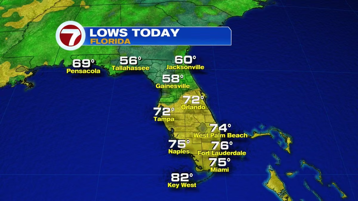 Vivian Gonzalez
@VivianGonzalez7
The wave in Central Atlantic has been designated INVEST 92L. It looks like it will miss the Caribbean islands late this week as it turns to the North. @wsvn
 Vivian Gonzalez
@VivianGonzalez7
MONDAY 8AM TROPICS OUTLOOK- The chance during the next 48 hours has gone up to a 40% for a tropical wave to form over the Central Tropical Atlantic. During the next 7 days, it has a high chance. @wsvn
 Vivian Gonzalez
@VivianGonzalez7
Drier air is filtering in with some moisture lagging behind a stalled front. This means isolated storms still possible heading into the afternoon hours. @wsvn #flwx
Vivian Gonzalez
@VivianGonzalez7
FRIDAY 8AM TROPICS OUTLOOK- Tropical wave located near the West coast of Africa will be entering more favorable conditions for growth. It will have a medium chance to form during the next 7 days. @wsvn
 Vivian Gonzalez
@VivianGonzalez7
THURSDAY 8AM TROPICS OUTLOOK- A tropical wave is forecast to emerge off the coast of Africa and enter an area favorable for development. NHC giving it a low chance to form over the next 7 days. @wsvn
 Vivian Gonzalez
@VivianGonzalez7
There is still some fog in Ft. Lauderdale. @wsvn #flwx @nwsmiami @abcmiami18
 Vivian Gonzalez
@VivianGonzalez7
Once the fog fades, we will have plenty of sun to start. By the afternoon, numerous showers and storms may develop around most of South Florida. Clouds will linger early evening as conditions gradually dry out. @WSVN #flwx
Vivian Gonzalez
@VivianGonzalez7
AREAS OF FOG this morning around parts of Miami-Dade and Broward. Visibility dropping some in Ft. Lauderdale. @wsvn @abcmiami18 @nwsmiami #flwx

Vivian Gonzalez reposted
 Ginger Zee
@Ginger_Zee
What a beautiful morning meeting the weather superpowers at @wsvn 🙌
Vivian Gonzalez
@VivianGonzalez7
Thank you for stopping by @Ginger_Zee ☀️ 🌴 🏖️ @ABCMiami18 @GMA
 Vivian Gonzalez
@VivianGonzalez7
Thank you for stopping by @Ginger_Zee ☀️ 🌴 🏖️ @ABCMiami18 @GMA
Vivian Gonzalez
@VivianGonzalez7
Today marks the peak of hurricane season for the Atlantic basin and right now it is quiet. The peak for South Florida tends to be around mid-October, so stay tuned to your Storm Team for the latest. @wsvn @abcmiami18
 Vivian Gonzalez
@VivianGonzalez7
Miami International Airport the last 2 days has received better than 6 inches of rain and more is to come. #wsvn #flwx
 Vivian Gonzalez
@VivianGonzalez7
FLASH FLOODING RISK in place for parts of South Florida. Numerous showers and storms possible producing heavy rainfall rates, so street flooding concerns are likely. Remember if you can't see where the road ends or starts take another route. @wsvn #flwx
 Vivian Gonzalez
@VivianGonzalez7
Some storms have developed and impacting the lower Florida Keys from Cudjoe to Big Pine Key. @WSVN #flwx
Vivian Gonzalez
@VivianGonzalez7
Stunning sunrise this morning! @wsvn #flwx
Vivian Gonzalez
@VivianGonzalez7
Similar setup like last week with another front stalling to our North. This means early sunshine with periods of rain and storms possible each afternoon. Typical rain chances are in the forecast. Over the weekend, we could have drier air building in. @wsvn #flwx
Vivian Gonzalez
@VivianGonzalez7
MONDAY 8AM TROPICS OUTLOOK- The tropics are unusually quiet as we approach the peak of the season. @wsvn
Vivian Gonzalez
@VivianGonzalez7
FRIDAY 8AM TROPICS OUTLOOK- Tropical wave in the Eastern Atlantic remains with a high chance to form by the weekend. It will near the Lesser Antilles by the middle of next week. There is plenty of time to watch it. @wsvn #flwx
 Vivian Gonzalez
@VivianGonzalez7
UNSETTLED STRETCH- South Florida more clouds expected today with anytime showers and storms this afternoon and evening. Stalled front will remain in place for the next several days keeping the pattern unsettled. @wsvn #flwx
Vivian Gonzalez
@VivianGonzalez7
Anytime downpours likely this afternoon and street flooding will be possible. @wsvn #flwx
 Vivian Gonzalez
@VivianGonzalez7
THURSDAY 8AM TROPICS OUTLOOK- Tropical wave in the Eastern Atlantic is getting better organized. It could form into a depression by the weekend in the Central Atlantic and be near the Lesser Antilles by the middle of next week. @wsvn
 Vivian Gonzalez
@VivianGonzalez7
Showers and storms have developed and impacting the Florida Keys, including Southern Miami-Dade. @wsvn #flwx
Vivian Gonzalez
@VivianGonzalez7
South Florida today rain and storms will develop earlier in comparison to yesterday. Therefore, pack the rain gear and patience this afternoon. A few storms could be strong. @wsvn #flwx
Vivian Gonzalez
@VivianGonzalez7
TUESDAY 8AM TROPICS OUTLOOK- Tropical wave in the Eastern Atlantic has a high chance to form into a Tropical Depression or Storm later this week or weekend. Conditions appear favorable for growth. @wsvn
 Vivian Gonzalez
@VivianGonzalez7
Best chance of seeing some deep downpours this afternoon will be around metro and coastal locations. There is a marginal risk of seeing flooding, in spots. @wsvn #flwx
 Vivian Gonzalez
@VivianGonzalez7
A significant Earthquake happened last night in Afghanistan. The collision between the Indian and Eurasian plates caused this 6.0 earthquake in the magnitude scale. Over 800 people have been killed and sadly the number could rise. @wsvn
 Vivian Gonzalez
@VivianGonzalez7
LABOR DAY WEEKEND weather, plus what we can expect for the UM and Notre Dame Game.
@canesfootball #news #weather @wsvn @abcmiami18
Vivian Gonzalez
@VivianGonzalez7
LABOR DAY WEEKEND looking wet at times. We will have some dry time in the mornings and evenings, but widespread rain and storms possible in the afternoons. Temperatures near-normal with limited sunshine. @WSVN #flwx
 Vivian Gonzalez
@VivianGonzalez7
Area of low pressure and a slow-moving front across Northern Florida will maintain a high rain chance in the forecast this holiday weekend. @wsvn #flwx
Vivian Gonzalez
@VivianGonzalez7
THURSDAY 8AM TROPICS OUTLOOK- A tropical wave is forecast to emerge off the West coast of Africa over the WEEK. Conditions will be somewhat favorable for slow development as it moves West to West-Northwest at around 15- 20 mph in the Eastern Atlantic next week. @wsvn
 Vivian Gonzalez
@VivianGonzalez7
Periods of heavy rain and lightning impacting your commute right now around coastal Miami-Dade between Sunny Isles Beach through North Bay Village and Miami Beach. Use caution while driving. @wsvn #flwx
Vivian Gonzalez
@VivianGonzalez7
THURSDAY 5AM ADVISORY- #fernand lost tropical characteristic and this is the last advisory by NHC. @wsvn
 Vivian Gonzalez
@VivianGonzalez7
DRENCHING DOWNPOURS expected heading into the long weekend. The chance of rain is going up gradually this week. @wsvn #flwx
 Vivian Gonzalez
@VivianGonzalez7
BIG GAME on @abcmiami18 this Sunday at 7:30pm. UM taking on Notre Dame! If you have tailgating plans, make sure you take them indoors. The weather may be wet at times. Conditions start to improve by kickoff. @wsvn #flwx


