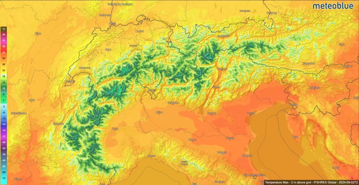
โ๏ธ Heavy snowfall increases avalanche danger in the Alps
Moist westerly airflow continues to bring heavy snowfall to the western Alps.
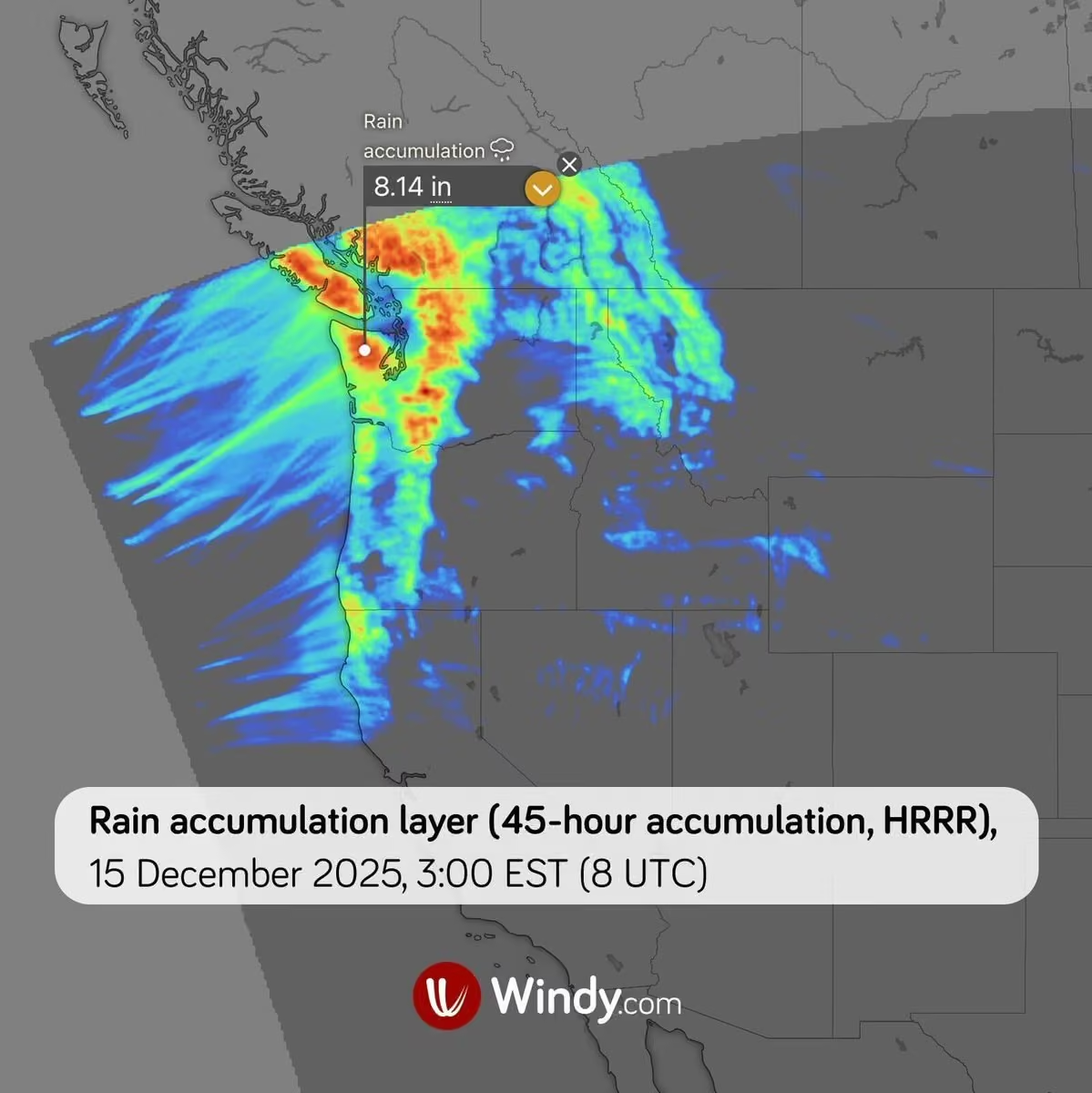
Over the past two days, 20โ60 cm of fresh snow has fallen at elevations above 1,800 m on the northern and northwestern windward slopes of the French and Swiss Alps (Mรฉtรฉo-France, White Risk).
Heavy snowfall is expected to continue across the western Alps until Saturday, when it will temporarily stop.
By Saturday morning, another 20โ60 cm of fresh snow is expected at elevations between 1,600 and 2,000 m, with up to 80 cm along the main Alpine ridge.
At elevations above 2,000 m, more than 100 cm of fresh snow could fall locally.
โ ๏ธ Fresh snow combined with strong winds is significantly increasing avalanche danger, which has already reached Level 3 (Considerable) across large parts of the French and Swiss Alps at elevations above 2,400 m.
Windy (weather service)
Windy.com is a weather visualization platform that provides interactive global weather maps and forecasting tools. Founded in November 2014 by Ivo Lukaฤoviฤ, the service is headquartered in the Czech Republic. Originally created as a wind visualization project, Windy has expanded into a comprehensive weather platform displaying forecasts, radar and satellite imagery, and meteorological data such as wind, temperature, precipitation and pressure. More on Wikipedia
-
Windy.com
@Windycom
-
Windy.com
@Windycom
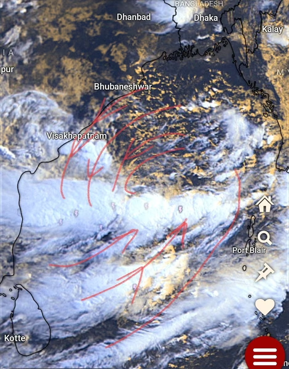
๐ Cyclone Akvan strengthens over the Bay of Bengal, approaches India's east coast
Severe Cyclonic Storm Akvan is slowly moving north-northwestward towards India's east coast.
As of noon on Wednesday, 18 November, Akvan was estimated to be about 570 km east of Chennai, with sustained winds of 90โ100 km/h (25โ28 m/s), gusting up to 110 km/h (31 m/s). Its broad, poorly defined circulation makes the exact position of its centre difficult to determine.
Akvan's forecast track and landfall location remain highly uncertain. Model predictions show a spread of approximately 500 km in possible landfall locations.
Further intensification is expected, with sustained winds potentially reaching 100โ110 km/h (28โ31 m/s) and gusts up to 120 km/h (33 m/s). Akvan could make landfall along the coast between Kakinada and Puri around midday on Friday, 20 November, although the exact location and timing remain uncertain.
โ ๏ธ Main hazards for eastern India, particularly coastal Andhra Pradesh and southern Odisha:
Strong winds: Gusts up to 120 km/h (33 m/s), potentially damaging buildings, trees and power lines.
Heavy rainfall: Totals exceeding 150 mm, locally reaching 200 mm, on 19โ20 November. Flash floods, river flooding and landslides are possible.
Storm surge and dangerous seas: Coastal flooding and high waves are possible, especially in low-lying areas.
Akvan is expected to weaken rapidly after landfall, although heavy rainfall may persist inland. -
Windy.com
@Windycom
๐จ๐ง๏ธ One frontal system after another sweeps into Europe from the west
Strong westerly (zonal) flow will dominate much of Europe until at least Friday, bringing frequent frontal passages, strong winds and locally heavy precipitation.
The zonal flow results from a strong pressure gradient between deep low-pressure systems over the North Atlantic and northern Europe and a powerful high-pressure system centred west of the Canary Islands. Its ridge extends across the Mediterranean to the Middle East. This flow brings moist Atlantic air into Europe. Supported by the jet stream, low-pressure systems and their associated fronts move eastwards.
Frontal passages will be accompanied by strong wind gusts. Early in the week, Ireland and western and northern France will be particularly affected, with gusts reaching up to 100 km/h. Strong winds are also expected along the western coast of Great Britain, the coasts of the Iberian Peninsula, on the islands of the western Mediterranean, and across parts of Italy and the Balkans. Winds will also strengthen around the Black Sea in the second half of the week.
The heaviest precipitation will affect western and southern Europe, particularly mountainous regions where orographic effects will enhance precipitation. Precipitation totals could locally exceed 250 mm in the western Balkans, while 100โ150 mm is expected in parts of northwestern Spain, Portugal and the western Alps, and around 100 mm in the northern Apennines. Flash floods, river flooding and localised landslides are possible.
Higher elevations of the western Alps could receive 40โ80 cm of fresh snow, locally more than one metre. Snowfall and strong winds will increase avalanche danger, particularly in the French and Swiss Alps. -
Windy.com
@Windycom
๐ Storms Bruna and Charles bring heavy rain to the Iberian Peninsula
Storm Bruna has been bringing moist Atlantic air and heavy rainfall to the Iberian Peninsula since Sunday.
Another storm, Charles, is expected to bring further heavy rain and strong winds, particularly on Wednesday, with conditions gradually easing on Thursday.
Heavy rainfall: Total rainfall over the entire episode could reach 200โ300 mm south of the Sistema Central mountain range and 100โ200 mm in parts of western Andalusia.
Strong winds: Gusts of 70โ90 km/h (19โ25 m/s) are expected in exposed areas, locally reaching 100โ120 km/h (28โ33 m/s) in mountainous areas.
โ ๏ธ AEMET has issued red (extreme danger) rainfall warnings for northern Cรกceres and southern รvila in Spain on Tuesday, 10 November, with around 120 mm possible in just 12 hours. Flash flooding and rapidly rising river levels are possible. Exercise extreme caution! -
Windy.com
@Windycom
๐ง๏ธโ๏ธ Another round of heavy rainfall hits the western Mediterranean
Another episode of heavy rainfall is beginning in the western Mediterranean, accompanied by thunderstorms and strong winds. From Wednesday, 4 November, it will mainly affect southern France, Corsica and Sardinia.
This Mediterranean rainfall episode (รฉpisode mรฉditerranรฉen) is typical of autumn. According to Mรฉtรฉo-France, such episodes occur 3โ6 times a year. Warm, moist air from the Mediterranean Sea drives them, and mountainous terrain often enhances rainfall.
In southern France, heavy rain is expected across Languedoc, the Gulf of Lion and the lower Rhรดne Valley. According to Mรฉtรฉo-France, Wednesday's totals could reach 30โ50 mm, with local totals up to 100 mm. On Thursday, up to 150 mm is possible in parts of Hรฉrault and Gard.
In Corsica, rain will intensify overnight into Thursday, with over 200 mm possible on the eastern side of the island on Thursday alone and up to 300 mm over the entire episode. Some numerical models suggest even higher totals.
In Sardinia, the heaviest rain and thunderstorms are expected in the east and northeast, potentially continuing through Thursday.
โ ๏ธ Main hazards include flash floods, overflowing rivers and landslides. Some areas were already hit by heavy rain on 19โ20 October, so soils may already be saturated. -
Windy.com
@Windycom
๐ Cyclone Murasu: Second tropical cyclone to make landfall in Andhra Pradesh in just one week
Murasu made landfall as a Severe Cyclonic Storm. Its centre crossed India's east coast near Ongole, Andhra Pradesh, between 3:30 and 5:30 AM IST today, Tuesday, 3 November.
After making landfall, Murasu began weakening rapidly and is now moving very slowly north-northwestwards. However, it continues to bring extremely heavy rainfall and strong winds, with gusts of up to 80 km/h still possible.
Over the next 24 hours, rainfall totals of 50โ100 mm are expected in parts of coastal Andhra Pradesh between Ongole and Visakhapatnam, with up to 150 mm possible locally.
Heavy rainfall may cause rivers and streams to rise and trigger flash flooding, particularly in low-lying areas.
โ ๏ธ Stay updated with the latest official weather warnings. -
Windy.com
@Windycom
๐ง๏ธโ๏ธ Storm Agneta brings heavy rain, thunderstorms and flooding to the central and eastern Mediterranean
Storm Agneta, centred over the Tyrrhenian Sea, is bringing heavy rain, thunderstorms and strong winds across the Mediterranean, with the most significant impacts reported in Greece.
In Greece, Agneta has caused flash flooding, landslides and infrastructure damage. Thasos recorded 144 mm of rain by Sunday evening, 1 November. Roads and buildings were flooded on Rhodes and Samos, with disruption also reported on Kalymnos and in Volos.
In Italy, gusts approaching 70 km/h have been recorded in Sicily, while heavy rain and thunderstorms are affecting Campania, Basilicata and Puglia.
What is expected next?
On Monday, 2 November, and Tuesday, 3 November, the low-pressure system will continue moving eastwards, first over the Ionian Sea and then towards the Aegean Sea.
Heavy rain and thunderstorms will continue across southern Italy and Greece. Forecast models indicate rainfall totals of 50โ100 mm across Greece over the event, with local totals exceeding 150 mm. The greatest risks are for the Ionian Islands, western and southern Peloponnese, northern Greece and the Aegean islands. Western Turkey's coast will also be affected.
Strong winds will continue across Italy, with gusts potentially reaching 100 km/h, particularly in central and southern regions and on the islands. Over Greek waters, winds may reach 60 km/h, with locally higher speeds generating large waves and dangerous sea conditions.
โ ๏ธ Main hazards: Torrential rain, flash floods, landslides, strong winds, high waves and localised hail. -
Windy.com
@Windycom
๐ Very Severe Cyclonic Storm Arnab approaches India. Heavy rain and strong winds hit the east coast
Tropical Cyclone Arnab continues to intensify rapidly over the warm waters of the Bay of Bengal. Heavy rain and strengthening winds are already affecting Andhra Pradesh's coast, India.
Arnab is moving westwards but slowing down, partly due to its interaction with another tropical disturbance, Invest 90B, located southeast of the cyclone. This interaction also increases uncertainty in Arnab's forecast track.
Landfall is expected on Wednesday morning, 28 October, in the Godavari River delta region. According to the India Meteorological Department (IMD), maximum sustained winds at landfall are forecast to reach 125โ135 km/h (35โ38 m/s), with gusts up to 150 km/h (42 m/s).
After landfall, the cyclone may initially weaken more slowly than usual. Saturated soil and flooded areas in the delta could continue supplying moisture and energy, an effect known as the brown ocean effect.
Arnab is expected to turn northwards and weaken rapidly after leaving the delta. However, moisture associated with the cyclone may spread further north, bringing heavy rain to inland areas.
โ ๏ธ Main hazards:
The Andhra Pradesh coast is particularly at risk, especially around Kakinada, Yanam, and the Godavari River delta.
The cyclone's slow movement increases the risk of prolonged heavy rain and widespread flooding.
Very strong winds: Falling trees, building damage, and power outages are possible.
Extreme rainfall: Local 24-hour totals could exceed 200 mm, with flash floods, widespread flooding and landslides possible.
Coastal flooding: Storm surge could raise sea levels by 1โ2 m above the astronomical tide, particularly near Kakinada and Yanam. Dangerous waves will also affect the coast.
Stay updated with the latest forecasts and official weather warnings. -
Windy.com
@Windycom
Twice the screen, same Windy.
Weโve optimised the app for iPhone Duo, so the whole map and forecast table fit on one screen when itโs open, and your widgets and alerts stay one glance away when itโs closed. ๐ฒ -
Windy.com
@Windycom
๐ง๏ธโ๏ธ Heavy rain and thunderstorms affect Greece, the Aegean Sea and Turkey
A well-developed, cold-core low-pressure system over Greece and the Aegean Sea is driving intense rainfall and thunderstorms across the eastern Mediterranean.
Heavy rain is mainly affecting eastern Greece, the Aegean islands and the Istanbul area. In the coming hours, intense rainfall is expected to extend further south.
The heaviest rainfall and thunderstorms are expected this afternoon and on Wednesday, particularly in the following areas:
๐ฌ๐ท Eastern Greece: Thessaly, the Sporades, Euboea and the Dodecanese Islands.
๐น๐ท Western and southwestern Turkey: Particularly the provinces of Muฤla, Antalya and Denizli.
Showers and thunderstorms may continue over the coming days, gradually shifting eastwards.
Rainfall totals will vary significantly from place to place. By the end of October, accumulations could exceed 120 mm, particularly in exposed coastal and mountainous areas.
โ ๏ธ The main hazards include flash flooding, landslides, strong winds and localised hail during thunderstorms. Meteorologists also warn of possible tornadoes in coastal areas of western and southwestern Turkey.
Stay up to date with the latest forecasts and official weather warnings. -
Windy.com
@Windycom
๐ Tropical Cyclone Arnab rapidly intensifies over the Bay of Bengal
Cyclone Arnab is about 600 km east-southeast of Kakinada, India, moving westwards.
Maximum sustained winds reach 120 km/h (33 m/s), with gusts up to 150 km/h (42 m/s).
Further intensification is expected, with favourable conditions: sea surface temperatures of 29โ30 ยฐC, abundant moisture and low vertical wind shear.
Arnab will continue westwards before turning northwards near India's coast. Landfall is expected near Kakinada, Andhra Pradesh, on Wednesday morning, 28 October, although the exact timing remains uncertain. The cyclone will then move northwards and gradually weaken over land.
Main hazards for India's east coast, particularly Andhra Pradesh:
Strong winds: Sustained winds of 100โ120 km/h, gusting to 140 km/h, at landfall.
Heavy rain and thunderstorms: Totals of 100โ250 mm, locally up to 400 mm, with flash flooding possible.
High waves and coastal flooding: Waves up to 5 m, with storm surge potentially raising sea levels by 1โ1.5 m above astronomical tide and flooding low-lying coastal areas.
โ ๏ธ Follow official weather warnings. -
Windy.com
@Windycom
๐ Storm Austen sweeps impressively along the English Channel
The centre of Storm Austen moved across the English Channel from Thursday evening, 22 October, to Friday afternoon, 23 October 2026. The storm brought very strong winds and heavy rainfall, causing widespread disruption, particularly in Ireland, the UK and northwestern France.
The strongest wind gusts recorded so far:
๐ฌ๐ง United Kingdom
St Mary's Airport, Isles of Scilly: 122 km/h (76 mph)
Portland, Dorset: 121 km/h (75 mph)
Needles Old Battery, Isle of Wight: 121 km/h (75 mph)
๐ซ๐ท France
Pointe du Raz: 161 km/h
Ouessant: 158 km/h
รle de Groix: 150 km/h
New October wind gust records were set at several weather stations in France.
๐ฎ๐ช Ireland
Roche's Point: 106 km/h
The storm continued east towards Belgium and the Netherlands.
Storm Austen is now giving way to Storm Boelo, which is expected to bring another round of strong winds and heavy rain to Northern Ireland and northern parts of the UK over the weekend. -
Windy.com
@Windycom
๐ Typhoon Champi approaches Taiwan
Typhoon Champi is bringing very strong winds, torrential rain and high waves to Taiwan and nearby Japanese islands.
Across Japan's Sakishima Islands, wind gusts exceed 100 km/h (28 m/s), with 113 km/h (31 m/s) recorded on Yonaguni Island. Miyakojima has received approximately 200 mm of rain in the past 24 hours.
Champi is about 400 km from Taipei. Maximum sustained winds reach 180 km/h (50 m/s), with gusts up to 215 km/h (60 m/s). The typhoon is moving northwestwards at 18 km/h (5 m/s).
Champi will approach northeastern Taiwan on Friday before turning northeastwards towards southern Japan over the weekend. It could affect Kyushu early next week, with sustained winds expected to weaken to 55โ65 km/h (15โ18 m/s). Champi will gradually weaken and eventually transition into an extratropical cyclone.
Main hazards for the northeastern half of Taiwan and nearby islands:
Very strong winds: Gusts may exceed 100 km/h (28 m/s).
Extreme rainfall: Northern and northeastern Taiwan could receive 100โ400 mm, locally up to 500 mm, and over 600 mm in mountainous areas. Taipei could see more than 300 mm. Flooding and landslides are possible.
High waves: Waves may reach 8 m, occasionally up to 10 m.
โ ๏ธ Stay updated with the latest official weather warnings. -
Windy.com
@Windycom
๐จ Storms Austen and Boelo to bring severe weather to northwestern Europe
Two powerful Atlantic storms, Austen and Boelo, will bring very strong winds, heavy rainfall and rough seas to northwestern Europe from Thursday evening through the weekend.
๐ Storm Austen is undergoing explosive cyclogenesis as it approaches Ireland and the UK. A strong jet stream over the Atlantic is contributing to its rapid deepening.
Overnight into Friday, Austen will mainly affect southern and eastern Ireland before moving along the English Channel, with severe weather expected across southern England and northern and northwestern France.
Wind gusts may reach 110โ130 km/h (70โ80 mph) in exposed areas. Falling trees, power outages and transport disruption are possible. Large waves are also expected along the coasts of Ireland, Brittany, Wales and southern England.
The storm will also bring heavy rainfall, with totals of 20โ40 mm, locally reaching 60โ80 mm. This could lead to localised flooding.
By Friday afternoon, the storm will move over the southern North Sea, extending its impacts to the Benelux countries and northwestern Germany.
๐ Storm Boelo is currently developing over the Atlantic and is expected to deepen significantly on Friday and Saturday. From Saturday into Sunday, it will bring another round of heavy rainfall and very strong winds, mainly affecting Northern Ireland, Scotland and northern England.
โ ๏ธ Damaging winds, dangerous coastal conditions and localised flooding are expected. Stay up to date with the latest weather warnings. -
Windy.com
@Windycom
๐ Super Typhoon Champi heads towards Taiwan
Champi is already the fifth super typhoon of 2026 in the western North Pacific.
At 12:00 UTC, its centre was located approximately 580 km north of Yap. Maximum sustained winds were around 260 km/h (72 m/s), with gusts reaching 315 km/h (87 m/s). The typhoon is moving northwest at around 25 km/h (7 m/s).
Over the next few days, Champi is expected to continue generally northwestwards while gradually weakening. However, from Thursday, uncertainty over its future track increases significantly.
Some model scenarios suggest Champi could cross Taiwan on Saturday and continue towards China's east coast. Others indicate a more pronounced turn towards the north or northeast, which could bring the typhoon close to the Ryukyu Islands from Friday into the weekend, and later towards the Japanese islands of Kyushu and Honshu.
โ ๏ธ Please follow the latest weather forecasts. -
Windy.com
@Windycom
๐ง๏ธโ๏ธ Heavy rain and flooding in the western and central Mediterranean
Heavy rain has affected Spain's Valencia region since the weekend. The rainfall is associated with Adam, the first named system of the 2026/2027 season. Adam is an isolated upper-level low, an area of cold air aloft that has become cut off from the main atmospheric flow. It increases atmospheric instability and supports the development of severe thunderstorms and very intense rainfall.
More than 300 mm of rain has fallen locally in the Valencia region in 24 hours, with totals since Saturday exceeding 500 mm in some areas.
The area of intense thunderstorms and heavy rainfall is now shifting towards the Balearic Islands and southern France. Very high rainfall totals are expected in southeastern France. In the Cรฉvennes, 300 to 350 mm could fall locally, about a month and a half of typical rainfall.
On Tuesday, heavy rain and thunderstorms will also spread into northern Italy, particularly Liguria, before moving farther towards the Balkans.
โ ๏ธ In the affected areas, intense rainfall could trigger flash flooding and significant rises in river levels. -
Windy.com
@Windycom
๐ Hurricane Trudy rapidly strengthens into a major hurricane
Hurricane Trudy has rapidly intensified overnight into a Category 3 hurricane, with maximum sustained winds reaching 195 km/h (120 mph). It is expected to strengthen further.
Trudy is moving slowly northwestward and is forecast to approach Mexico's southwestern and west-central coasts this weekend, potentially remaining a major hurricane.
Most forecast models keep Trudy's centre offshore. However, even small track changes could significantly affect the severity of impacts along the Mexican coast.
Main threats include damaging winds, storm surge, torrential rainfall and dangerous waves. Heavy rainfall could trigger life-threatening flash floods and landslides, particularly in Michoacรกn, Colima and Jalisco, Mexico.
โ ๏ธ Follow official warnings and forecast updates. -
Windy.com
@Windycom
Three tropical cyclones will hit North America this weekend
๐ Hurricane Isaias
It is strengthening over the Gulf of Mexico and is currently a Category 2 hurricane, likely to briefly reach Category 3. Its centre is expected to make landfall around 8:00 PM local time near the AlabamaโFlorida Panhandle border, close to Pensacola.
Parts of the Gulf Coast face a life-threatening storm surge and damaging hurricane-force winds. Heavy rain will also bring a risk of flash, urban and river flooding across the southeastern United States.
๐ Hurricane Simon
It is expected to reach Mexico's southwestern coast on Saturday evening and strengthen into a Category 4 hurricane today over the warm eastern Pacific. As it nears the coast, it is already bringing strong winds and intense rainfall, particularly around Lรกzaro Cรกrdenas. Severe weather will spread north towards Manzanillo, Puerto Vallarta and Tepic.
Life-threatening winds, storm surge, heavy rain, flooding and landslides are possible. Dangerous surf and rip currents will affect the coast through the weekend.
๐ Tropical Storm Rachel
It is expected to move inland over northern Baja California early Sunday and continue into the southwestern United States later that day. It will bring strong wind gusts and heavy rain, with a risk of flash and urban flooding. Dangerous surf and rip currents are also expected along Southern California and northern Baja California. -
Windy.com
@Windycom
๐ Isaias becomes the first hurricane of this yearโs Atlantic season
Hurricane Isaias strengthened from a tropical storm into a hurricane at 03:30 UTC on 8 October 2026. It became the first Atlantic hurricane of the 2026 season and the latest first hurricane since the beginning of the satellite era. It also tied the 1905 mark for the latest first hurricane in the historical Atlantic record.
Typically, the first Atlantic hurricane forms around 11 August, according to NOAA/NHCโs 1991โ2020 climatology.
Isaias is located north of the Yucatรกn Peninsula and is moving northeastward. It is expected to gradually turn northward, with its centre forecast to make landfall somewhere between eastern Louisiana and western Florida overnight into Saturday. The system will then continue farther across the southeastern United States over the weekend and gradually weaken.
Main threats to the coasts of Louisiana, Alabama and western Florida:
Wind: Winds will begin strengthening in coastal areas today. At landfall, maximum sustained winds may exceed 100 mph (160 km/h), with even stronger gusts.
Rain: Intense rainfall is expected, with local totals of up to 10 in (250 mm). Flash flooding and urban flooding are possible, along with isolated river flooding.
Storm surge and high waves: The combination of storm surge, high waves and high tide may flood low-lying coastal areas. Life-threatening surf and strong rip currents are also possible.
โ ๏ธ Please follow official warnings. -
Windy.com
@Windycom
๐ Hurricane Nolo becomes Typhoon Nolo / Typhoon No. 28
On Sunday, 4 October at 21:00 UTC, Hurricane Nolo crossed the International Date Line and entered the western Pacific, where it was reclassified as a typhoon.
The system may now be referred to as Typhoon Nolo, while its original identifier, 15E, may still appear in some contexts. RSMC Tokyo/JMA lists it as Typhoon No. 28.
Responsibility for the system also shifted from the Central Pacific Hurricane Centre to RSMC Tokyo/JMA.
This is the first hurricane-to-typhoon transition since Dora in August 2023.
Nolo first formed in the eastern Pacific on 13 September as Tropical Depression Fifteen-E. In mid-September, it temporarily weakened below tropical cyclone status, but later re-formed and strengthened into a hurricane. It then passed south of Hawaii as it continued westward across the central Pacific. After more than three weeks travelling across the Pacific, it reached the International Date Line. So far, it has travelled more than 7,000 km (4,300 mi).
Nolo is continuing generally westward and is expected to maintain a similar intensity in the short term. Gradual weakening should follow later.
On Thursday, 8 October, it is forecast to pass north to northeast of the Japanese island of Minamitorishima. It should then gradually turn northwestward and continue into waters south to southeast of Japan. -
Windy.com
@Windycom
๐ Rachel becomes a major hurricane
Hurricane Rachel has strengthened into a Category 3 major hurricane, becoming the eighth major hurricane of the season in the central and eastern North Pacific.
Its outer rainbands are bringing heavy showers and thunderstorms to southern Baja California. Large waves are affecting the southern part of the peninsula and Mexico's west coast.
At 1:00 AM MST on Friday, 2 October 2026, Rachelโs centre was located about 420 km (260 miles) south of Cabo San Lucas, near the southern tip of Baja California. Maximum sustained winds are around 190 km/h (120 mph), with gusts up to 240 km/h (150 mph). The hurricane is moving very slowly westward at around 4 km/h (2 mph).
Rachel is expected to strengthen into a Category 4 hurricane within the next few hours and pass very close to the uninhabited San Benedicto Island, north of Socorro Island.
Rachel will then continue moving westward and is expected to gradually weaken.
โ ๏ธ Large waves generated by Rachel will continue to cause dangerous surf and rip currents along the west-central coast of Mexico and the Baja California Peninsula. -
Windy.com
@Windycom
โ๏ธ Severe thunderstorms will affect eastern Spain, with extremely high rainfall totals possible
Thunderstorms are beginning to develop across eastern Spain and the Balearic Islands. Their development is linked to strengthening easterly winds, which are bringing large amounts of moisture from the Mediterranean Sea into the lower atmosphere. As a result, the storms may produce exceptionally intense rainfall.
The Spanish meteorological service AEMET has issued warnings for extreme rainfall from this afternoon into Friday morning, roughly for coastal areas between Reus and Valencia.
Intense and repeated thunderstorms and showers may produce more than 90 mm in one hour and 200โ300 mm in less than 12 hours. Flash flooding is possible.
On Friday, severe thunderstorms may also affect southeastern Spain.
โ ๏ธ Please follow official weather warnings and forecasts. -
Windy.com
@Windycom
๐ง๏ธโ๏ธ Heavy rainfall and a risk of flash flooding across the Southern and Central Plains, USA
A frontal boundary is moving across the central United States, with thunderstorms developing along and ahead of the front.
Their development is supported by abundant moisture from the Gulf of Mexico, combined with unusually high tropical moisture associated with the remnants of Hurricane Polo. The front will move slowly, allowing thunderstorms to repeatedly affect the same areas.
Today, Thursday, the heaviest rainfall is expected mainly across Texas and the Southern Plains. The highest totals and most significant impacts are forecast in the Texas Hill Country. According to the NOAA/NWS Weather Prediction Centre (WPC), hourly rainfall rates are likely to reach 1โ2 inches per hour (25โ50 mm/h), with short-term rates potentially as high as 3โ4 inches per hour (75โ100 mm/h). Repeated thunderstorms could bring more than 6 inches (150 mm) of rain in 24 hours.
Numerous flash floods, rapid rises on small streams and mudflows in some areas are possible.
Heavy rainfall is also expected farther northeast, particularly across Iowa, Illinois, Wisconsin and the Mid-Mississippi Valley.
On Friday, the main risk will shift towards southern, central and eastern Texas, where another 50โ100 mm of rain may fall. Heavy rainfall will also spread along the Gulf Coast and farther towards the Ohio Valley.
โ ๏ธ The main hazards remain flash flooding, flooded roads and mudflows in some areas. -
Windy.com
@Windycom
๐ง๏ธโ๏ธ A major Mediterranean rainfall event is affecting southern France, the first of the season
Very heavy rain accompanied by thunderstorms has been affecting southern France, especially the Languedoc region, since Tuesday. Rainfall intensity may increase further today. On Thursday afternoon, the most intense storm-related rainfall is expected to gradually shift eastwards.
According to Mรฉtรฉo-France, hourly rainfall totals in the Cรฉvennes may reach 50โ80 mm, while total rainfall over the event may reach around 200 mm, locally 250โ350 mm.
โ ๏ธ Such intense and persistent rainfall can trigger flash floods, river flooding, landslides and mudflows.
What is a Mediterranean rainfall event?
It is a period of very intense rainfall that most often affects the French Mediterranean regions in autumn. Warm, moist air from the Mediterranean Sea moves inland and, as it is forced to rise over mountainous terrain, favours the development of strong and repeated thunderstorms. Over several hours to several days, rainfall totals can therefore far exceed typical monthly amounts.
These events occur on average three to six times a year, mainly between September and December.
Windy.com
@Windycom
๐Measurements from Montpellier airport
www.windy.com/station/ad-LFMT?43.529,4.197,11,p:temp -
Windy.com
@Windycom
๐ง๏ธโ๏ธ Severe weather will affect the eastern Mediterranean and the Aegean Sea
A period of very unsettled weather is developing across parts of the eastern Mediterranean, bringing heavy rain, thunderstorms and strong winds.
The greatest risk of very heavy rainfall is currently centred on Crete, where the Hellenic National Meteorological Service (HNMS) warns of locally very heavy rain and thunderstorms, especially in northwestern Crete. These conditions may continue intermittently into the weekend.
The heavy rainfall is linked to a low-pressure system over the eastern Mediterranean, which is drawing moist air towards Crete. Combined with atmospheric instability and the islandโs mountainous terrain, this can significantly enhance rainfall totals.
Very strong northeasterly winds will affect much of the Aegean Sea, locally reaching gale force and creating very rough sea conditions.
โ ๏ธ The main hazards are intense thunderstorms, strong winds, flash flooding and dangerous conditions at sea. -
Windy.com
@Windycom
๐ Eight tropical systems are currently active across the Atlantic and Pacific
Two tropical storms, Hanna and Fay, are active in the Atlantic. Both are weakening and are likely to dissipate over the next few days. The Atlantic hurricane season remains exceptionally inactive. No hurricane has formed so far, and the total ACE (a measure of overall tropical cyclone activity) is only around 10% of the usual value.
In the Pacific, by contrast, this season is exceptionally active, partly due to the strengthening El Niรฑo.
Hurricane Polo, currently a Category 2 hurricane, is bringing strong winds and heavy rain to the Baja California Peninsula. Hazardous weather is shifting northeastward and will also affect northwestern mainland Mexico, where Polo is expected to weaken and dissipate. Moisture associated with its circulation may, however, reach as far as New Mexico in the United States.
Tropical Storm Rachel is strengthening over the eastern Pacific and is likely to reach hurricane intensity. Although its centre is expected to remain offshore, parts of Mexico's southwestern coast may still experience tropical-storm-force winds and locally heavy rainfall, with a risk of flooding and landslides.
Far out over the Pacific, between the Hawaiian Islands and the west coast of the Americas, tropical disturbance 91E is developing and is likely to become a tropical depression. Thunderstorm activity remains limited and disorganised for now.
Major Hurricane Nolo, currently a Category 3 hurricane, is located southwest of the Hawaiian Islands and is still generating high surf in Hawaii. It is expected to weaken as it moves north to northwest, but towards the end of this week and early next week it may still affect the Northwestern Hawaiian Islands with strong winds and high surf.
Tropical Depression 93W is developing over the western Pacific, east of the Mariana Islands. Over the coming days, it is expected to move mainly northwestward and strengthen. Early next week, it should pass near the Bonin Islands.
Tropical Storm Surigae, known in Japan as Typhoon No. 26, is moving southeast of Japan. Over the next few days, it is expected to track roughly parallel to the Japanese coast towards the northeast. During Wednesday and Thursday, it may affect the Kantล region, bringing strong wind gusts, high surf and, depending on its track, locally heavier rainfall. -
Windy.com
@Windycom
๐ Major Hurricane Polo reaches Category 5 again
Major Hurricane Polo has again strengthened into a Category 5 hurricane. When Polo first reached Category 5 intensity on Tuesday, 22 September, its central pressure dropped to 892 hPa, placing it among the most intense hurricanes ever recorded in the eastern Pacific.
At 7:00 AM MST (14:00 UTC) on Friday, 25 September, its centre was about 450 km (280 miles) from Manzanillo. It is moving westward, away from the Mexican coast, but the southwestern coast is still being affected by high surf and strong wind gusts.
Over the weekend, Polo is expected to turn north and then northeast. Early next week, it is forecast to strike the Baja California Peninsula. Its centre may cross the peninsula on Monday as a Category 1 or 2 hurricane.
On Tuesday, Polo will likely move over northwestern Mexico and make landfall near the Sonora-Sinaloa border.
Polo will bring strong winds, heavy rainfall and high surf, with the most significant impacts expected across the Baja California Peninsula and later in northwestern Mexico.
Moisture from Polo may also spread into the southwestern United States, contributing to heavy rainfall and a risk of flash flooding.
โ ๏ธ Please follow the latest weather forecasts and official warnings. -
Windy.com
@Windycom
๐ Hurricane Nolo approaches Hawaii: Catastrophic flooding threatens the Big Island
Hurricane Nolo, currently a Category 1 hurricane, is moving north-northeast towards Hawaii. At 8:00 PM on Thursday, 24 September, its centre was about 255 miles (410 km) south of South Point, Hawaii.
On Saturday, its track is expected to turn sharply westward.
Nolo is forecast to strengthen significantly and become a major hurricane over the weekend, likely reaching Category 4 intensity.
The eastern and southern parts of the Big Island are expected to see extremely heavy rainfall from Friday through Sunday. Totals of 14 to 28 inches (360 to 720 mm), locally up to 35 inches (890 mm) are forecast, bringing a risk of catastrophic and life-threatening flooding and landslides, especially in steep terrain.
On Maui, 4 to 8 inches (100 to 200 mm) are expected, locally up to 14 inches (360 mm), with life-threatening flooding and landslides possible.
Across the rest of the Hawaiian Islands, rainfall totals of up to 3 inches (75 mm) are expected, locally up to 6 inches (150 mm), with isolated flooding possible.
Other hazards on the Big Island include high surf and hurricane-force winds.
โ ๏ธ Please follow the latest weather forecasts and official warnings. -
Windy.com
@Windycom
๐ Typhoon Dujuan approaches Japan, bringing extreme rainfall
Typhoon Dujuan, known in Japan as Typhoon No. 25, is moving parallel to the coast of Honshu, with its centre remaining roughly 100 km offshore. Sustained winds are around 121 km/h (34 m/s), with gusts reaching 150 km/h (42 m/s). The typhoon is bringing very strong winds and intense rainfall.
On Izu Oshima Island, more than 700 mm of rain fell locally within 24 hours, while hourly rainfall totals exceeded 100 mm in isolated locations. A Level 5 landslide warning was also issued for the town of Oshima in the Izu Islands.
The typhoon continues to move northeastwards and is expected to come very close to the Kanto-Koshin region overnight. Depending on its exact track, very strong winds with gusts around 90 km/h (25 m/s) are expected, with even stronger gusts over the sea. Extremely heavy rain and localised torrential downpours are also forecast, with isolated rainfall totals reaching around 200 mm. Flash flooding and landslides are possible.
On Tuesday, the typhoon is expected to move gradually farther northeastwards over the open ocean, while hazardous weather conditions across Honshu gradually ease. -
Windy.com
@Windycom
๐ Tropical Storm Dujuan is moving across the northwestern Pacific
After passing east of the Mariana Islands, Dujuan (known in Japan as Typhoon No. 25) is now turning northwest along the western edge of a subtropical ridge centred east of Japan.
Thursday, 17 September, 09:00 UTC:
Location: about 800 km southeast of Iwo Tล (JP)
Intensity: sustained winds 93 km/h (25 m/s), gusts 120 km/h (33 m/s)
Movement: northwest at 54 km/h (15 m/s)
Dujuan is expected to slow down while continuing northwest. During Friday and Saturday, it will pass near the Bonin Islands and may briefly strengthen into a Category 1 typhoon on the SaffirโSimpson scale, with sustained winds around 120 km/h and gusts up to 150 km/h.
It will then turn north and northeast, tracking along Japanโs eastern coast. The storm should come closest to Honshu overnight into Monday.
Main risks for eastern Honshu on Sunday and Monday:
โข Gusts around 100 km/h along the Kantล coast, locally up to 120 km/h on the Izu Islands
โข Rainfall of 100โ200 mm, locally over 250 mm along the Pacific coast of Kantล and Tลkai and on the Izu Islands
โข Waves up to 6.5 m in exposed areas
โ ๏ธ Please follow official warnings. -
Windy.com
@Windycom
๐จ Windy conditions across the Mediterranean: Mistral, Tramontane and Meltemi are picking up
Local winds across the Mediterranean, including the Mistral, Tramontane and Meltemi, are strengthening.
They will continue to blow with varying intensity for several days, with gusts reaching up to 80 km/h.
They will probably ease temporarily towards the end of this week. However, they may strengthen again early next week, with the Bora potentially joining in.
๐ฅ Strong winds combined with dry vegetation significantly increase the risk of wildfires.
๐ Conditions at sea will deteriorate, with waves temporarily reaching around 2 metres.
Mistral ๐ซ๐ท
โข Direction: from northerly directions
โข Area: Rhรดne Valley and the western Mediterranean
โข Typical occurrence: year-round, strongest from autumn to spring
Tramontane ๐ซ๐ท๐ช๐ธ
โข Direction: from northerly directions
โข Area: southern France, northeastern Spain, the Balearic Islands, Corsica and Sardinia
โข Typical occurrence: year-round, strongest from autumn to spring
Meltemi ๐ฌ๐ท๐น๐ท
โข Direction: from northerly directions
โข Area: mainly the Aegean Sea
โข Typical occurrence: from late spring to early autumn
Bora ๐ญ๐ท
โข Direction: from the northeast
โข Area: along the Adriatic coast below the Dinaric Alps
โข Typical occurrence: mainly during the colder half of the year -
Windy.com
@Windycom
๐ A low-pressure system is deepening over the central Mediterranean, with medicane development not ruled out
A deepening low-pressure system is located over the Mediterranean Sea between Libya, Malta, southern Italy and Greece. The system is strengthening, bringing thunderstorms, strong wind gusts, intense rainfall and rough seas.
The pronounced convective system resembles a tropical depression. Whether it develops into a medicane (MEDIterranean hurriCANE) remains uncertain for now. The system would need to undergo convective restructuring and develop a distinct tropical-like character and a warm core.
The strengthening cyclone will continue moving eastwards.
On Tuesday, it may affect Greece, particularly the Peloponnese and western Crete, as well as the Ionian Islands.
On Wednesday, it may also affect eastern Crete and islands in the southern Aegean Sea.
โ ๏ธ Please follow official warnings. -
Windy.com
@Windycom
๐ง๏ธโ๏ธ Very heavy rain in western India
Severe thunderstorms are affecting India's west coast, bringing very intense rainfall and strong wind gusts.
The storms are linked to a low-pressure area over southern Rajasthan and northern Gujarat.
The most severe conditions are expected across Gujarat today (Monday) and tomorrow (Tuesday):
โข Very heavy rain, locally reaching extremely heavy rainfall, with 24-hour totals exceptionally exceeding 200 mm
โข Rainfall rates may exceed 15 mm per hour
โข Intense rainfall may lead to flash flooding
โข Thunderstorms may also produce wind gusts exceeding 60 km/h
Isolated stronger thunderstorms cannot be ruled out on Wednesday either.
โ ๏ธ Please follow official warnings.
According to the India Meteorological Department, conditions are expected to become increasingly favourable for the southwest monsoon to withdraw from some parts of western Rajasthan later this week. -
Windy.com
@Windycom
๐ Atlantic still without a hurricane: record-late arrival of the seasonโs first hurricane
No hurricane has formed in the Atlantic so far this season. According to NOAA/NHC, this has never happened this late in the season since the beginning of the aircraft reconnaissance era in 1944.
Climatologically, the peak of the Atlantic hurricane season falls on 10 September. So far this season, five named storms have formed in the Atlantic. Accumulated Cyclone Energy (ACE), a metric that accounts for both tropical cyclone intensity and duration, is 93% below the 1991โ2020 Atlantic average (NOAA/NHC).
Atmospheric conditions associated with El Niรฑo are contributing to the well-below-average Atlantic activity. -
Windy.com
@Windycom
โ๏ธ ๐ช๏ธ Severe thunderstorms threaten the western and central Mediterranean again
Very severe thunderstorms developed over the western Mediterranean on Wednesday (yesterday), with intense storms affecting mainly the Balearic Islands and the northern Adriatic.
On Thursday (today) and overnight into Friday, the area of possible thunderstorm development is shifting further east. Thunderstorms are expected to develop across the central Mediterranean and the northern Adriatic.
The most intense storms today are expected to affect mainly central and northern Italy, Slovenia and Croatia. An orange-level warning is also in effect in these areas.
The main threat will be heavy rainfall, as thunderstorms may repeatedly develop over the same areas. Locally, rainfall totals may exceed 150 mm, potentially causing devastating flash floods.
Thunderstorms may also produce wind gusts exceeding 100 km/h and hail larger than 4 cm. Due to the strong wind shear, organized storms including supercells may develop, and isolated tornadoes or waterspouts cannot be ruled out.
On Friday and Saturday, the area of possible thunderstorm development will shift somewhat southeastward. Storms will mainly affect southern Italy, the central and southern Adriatic Sea, and the Balkan Peninsula.
โ ๏ธ Follow the warnings issued by local meteorological services. -
Windy.com
@Windycom
๐๐ Almost a total lunar eclipse on the night of 27โ28 August
At maximum, about 96% of the Moonโs disk will be inside Earthโs dark central shadow, making this a very deep partial lunar eclipse that may look almost total. Only a thin bright edge of the Moon should remain visible, while the rest may turn coppery red.
The eclipse will be visible across most of North and South America, and parts of western Europe and western Africa. In Europe and Africa, it will take place in the early morning hours, with the Moon low in the western sky.
Eclipse timeline:
โข Penumbral eclipse begins: 01:23:55 UTC
โข Partial eclipse begins: 02:33:48 UTC
โข Maximum eclipse: 04:12:49 UTC
โข Partial eclipse ends: 05:51:55 UTC
โข Penumbral eclipse ends: 07:01:41 UTC
No eye protection is needed. Lunar eclipses are safe to watch with the naked eye.
โ๏ธ Will the weather cooperate?
Check the cloud forecast for your location to see whether the sky will stay clear enough to catch the eclipse. -
Windy.com
@Windycom
๐ Typhoon Saudel is approaching Japanโs Okinawa and Amami islands
As the typhoon approaches, waves are increasing, especially along east-facing coasts, winds are strengthening across the islands, and heavy rain is beginning to affect the region.
The centre of the typhoon will make its closest approach to the islands around midnight tonight and is expected to pass very close to Okinoerabujima Island.
As of Tuesday, 25 August at 15:00 JST (06:00 UTC):
Location: approximately 120 km southeast of Wadomari on Okinoerabujima Island, Japan
Intensity: sustained winds of around 46 m/s (165 km/h), with gusts up to 56 m/s (200 km/h)
Movement: northwestward at approximately 6 m/s (22 km/h)
The typhoon will continue moving northwestward. On Wednesday, over the East China Sea, its track is expected to begin turning southwestward and gradually weaken. Landfall along the Chinese coast, between Ningde and Fuzhou, is expected on Friday morning. The typhoon may also affect the weather in northern Taiwan.
Threats to Okinawa and Amami:
โข Rough seas and high waves: up to 11 m around the Amami Islands, 10 m around Okinawa, and 6 m near southern Kyushu
โข Damaging winds: gusts may reach up to 55 m/s (200 km/h)
โข Torrential rainfall: rainfall totals could exceed 250 mm locally across the Amami Islands and on Okinoerabujima, and 80 mm in parts of northern Okinawa
โ ๏ธ Follow the latest forecasts and official warnings. -

Windy.com
@Windycom
๐ Pacific tropical cyclone activity is surging, while the Atlantic remains well below average
Tropical cyclone activity varies significantly across the worldโs oceans. So far, activity has been highest in the northwestern Pacific, while the Atlantic remains well below average. This pattern is largely linked to the ongoing strengthening El Niรฑo.
Northwestern Pacific: well above average
According to the Japan Meteorological Agency (JMA), 21 typhoons have formed by 24 August. The last time such a high number had been recorded by this date was in 2018. JMA currently lists 21 systems for 2026.
If the current pace continues, this season could approach the record. Since records began in 1951, the highest annual total was recorded in 1967, with 39 typhoons (JMA).
According to Colorado State University, 16 named storms have already formed in the northwestern Pacific, almost four more than usual. ACE (Accumulated Cyclone Energy), which takes into account both the intensity and duration of tropical cyclones, is currently 77% above normal.
Central Pacific: very active in recent weeks
Three named storms have already occurred in the central Pacific this year, two more than usual. ACE is well above normal, 117% higher than the long-term average (NOAA/NHC).
Eastern North Pacific: around average
So far, 9 named storms have formed in the eastern Pacific, one more than usual. Overall activity according to ACE remains close to normal, at around 9% below normal (NOAA/NHC).
Atlantic: exceptionally inactive
Only 3 named storms have been reported so far, with no hurricanes and ACE around 87% below normal (NOAA/NHC). -
Windy.com
@Windycom
๐ Another tropical threat approaches Hawaii
Tropical Depression Two-C is approaching the Hawaiian Islands from the southeast. It will begin affecting the Big Island as early as Saturday, followed by islands farther west. It comes roughly a week after Hurricane Lala impacted the Hawaiian Islands last weekend.
At 00:00 HST (10:00 UTC) on Friday, 21 August 2026:
Location: approximately 770 miles (1,240 km) southeast of Hilo
Intensity: maximum sustained winds around 35 mph (55 km/h), with gusts up to 50 mph (80 km/h)
Movement: west-northwest at 10 mph (17 km/h)
The tropical depression is expected to continue to strengthen and is forecast to become Tropical Storm Moke today. Over the weekend and during the first half of next week, it is forecast to move south of the Hawaiian Islands.
โ ๏ธ Main hazards for Hawaii:
Heavy rainfall:
โข Big Island: 5 to 10 in (125 to 250 mm), locally up to 15 in (375 mm)
โข Maui: 1 to 2 in (25 to 50 mm), locally up to 3 in (75 mm)
โข Other islands: 1 to 2 in (25 to 50 mm)
The rainfall may cause life-threatening flooding and landslides, especially in steep terrain and in areas recently affected by Lala.
Strong winds: gusts may reach around 50 mph (80 km/h) on the Big Island and Maui, with stronger gusts possible in exposed mountainous terrain.
High waves: may reach around 8 ft (2.5 m) along windward coasts and exceed 10 ft (3 m) along the southern coast of the Big Island on Sunday.
๐ Meanwhile, Hurricane Lala, which briefly intensified to Category 2, is affecting the area around the uninhabited Laysan Island in the Northwestern Hawaiian Islands. It will move over cooler waters in the coming days and is expected to weaken significantly. -
Windy.com
@Windycom
๐ช๏ธโ๏ธ Severe weather outbreak across a large part of Europe today, with the strongest storms expected in northern Italy
Ahead of a wavy cold front stretching from the Baltic region across Central Europe and the Alps towards the Iberian Peninsula, very warm and humid air is flowing into Europe from the south to the southwest.
The main conditions for strong thunderstorms are therefore in place today:
โข an unstable and humid atmosphere โ warm air near the surface, cooler air aloft, and plenty of moisture, especially in the lower troposphere
โข a triggering mechanism provided by the wavy cold front, mountainous terrain and a jet streak in the upper troposphere
Vertical wind shear will also play an important role. Changes in wind speed and direction with height support storm organisation and increase the potential for severe weather.
Northern Italy, particularly the Po Valley, is expected to see the most favourable conditions for severe thunderstorms. The combination of strong instability (CAPE locally around 3,000 J/kg) and pronounced vertical wind shear (0โ6 km bulk shear above 20 m/s) will support the development of supercell thunderstorms. They are expected to move towards Slovenia and northern Croatia along the northern Adriatic.
Damaging wind gusts, tornadoes, large to very large hail, torrential rainfall with a risk of flash flooding, and significantly worsening conditions at sea are possible.
Severe thunderstorms may also occur elsewhere in a broad belt extending from Spain across Central Europe to the Baltic region.
On Friday, the main area of thunderstorms will shift further east together with the wavy cold front. Severe to very severe thunderstorms are expected across much of Italy, Corsica, Sardinia and Sicily, as well as Tunisia, Slovenia and Croatia. Strong thunderstorms may also occur in Central Europe.
โ ๏ธ Please follow the latest weather forecasts and official meteorological warnings. -
Windy.com
@Windycom
๐ง๏ธ โ๏ธ Heavy rainfall will affect South, Southeast and parts of East Asia in the coming days
The rainfall will be associated mainly with the southwest monsoon, several low-pressure systems, and, in part, with the tropical system Saudel, which could intensify into a typhoon. Intense downpours may cause dangerous flooding and landslides.
Significant rainfall totals may occur in the coming days, particularly in the following areas:
โข India โ central, northern and northeastern parts of the country and the Himalayan foothills, especially Madhya Pradesh, Uttar Pradesh, Himachal Pradesh, Bihar and Assam
โข Nepal
โข Bangladesh โ especially the north and northeast
โข Myanmar โ especially the Bay of Bengal coast and mountainous areas in the north
โข Thailand โ especially mountainous areas in the north, west and northeast
โข Cambodia โ especially the Gulf of Thailand coast and the northeast
โข Laos
โข Vietnam โ especially the north
โข China โ the South China Sea coast
โข Taiwan
โข Philippines โ especially the northwest
โ ๏ธ Please follow local weather forecasts and official warnings. -
Windy.com reposted
Reuters
@Reuters
Hurricane Lala hits Hawaii's Big Island x.com/i/broadcasts/1yxBePvnLpjJN
-
Windy.com
@Windycom
๐ Tropical Storm Lala to impact the Hawaiian Islands
Tropical Storm Lala is strengthening over the central Pacific and moving west-northwest. It will begin affecting the island of Hawaiสปi (Big Island) and Maui on Friday, followed by the islands farther west. It could become a hurricane as it nears Hawaiสปi. The centre of Lala is expected to approach the island on Saturday afternoon local time and may pass over it or very close by.
On Friday, 14 August 2026, at 00:00 HST (10:00 UTC):
Location: approximately 440 miles (710 km) from Hilo, Hawaiสปi
Intensity: winds around 60 mph (95 km/h), with gusts up to 70 mph (120 km/h)
Movement: west-northwest at 10 mph (17 km/h)
Lala will continue moving generally west-northwest, with its track expected to remain south of the Hawaiian Islands and roughly parallel to the island chain. It may weaken slightly on Sunday before strengthening again. Lala is expected to remain near the Hawaiian Islands through Sunday.
Risks for the Hawaiian Islands:
Wind:
On the windward sides of Hawaiสปi and Maui, wind gusts may exceed 85 mph (140 km/h). Across the remaining islands, gusts of around 65 mph (105 km/h) are expected. Winds could be even stronger at higher elevations.
Heavy rainfall:
Across Maui and Hawaiสปi, total rainfall of 8 to 12 inches (200 to 300 mm) is expected, with local totals of up to 25 inches (600 mm) possible on the island of Hawaiสปi.
Across the remaining islands, 2 to 6 inches (50 to 150 mm) of rain may fall, with isolated totals of up to 8 inches (200 mm).
Such rainfall amounts may cause life-threatening flooding, mudslides and landslides, especially in areas of steep terrain.
Rough seas and high waves:
Waves of up to 4 m are expected along the windward coasts of the islands. Combined with high tides, this may lead to flooding of low-lying coastal areas.
Track Tropical Storm Lala here: www.windy.com/-Hurricane-tracker/hurricanes/lala?satellitโฆ
โ ๏ธ Follow official forecasts and guidance from local authorities. -
Windy.com
@Windycom
๐ Tropical activity in the Atlantic is picking up
Three tropical systems are currently developing across the Atlantic.
94L โ Eastern Atlantic
94L is located approximately 1,000 km southwest of the Cabo Verde Islands. Conditions are expected to be favourable for further development, and a tropical depression could form late this week or over the weekend.
92L โ Central Atlantic
Tropical wave 92L is located roughly midway between the Lesser Antilles and the west coast of Africa and is becoming better organised as it moves west to west-northwest. Conditions remain favourable for now, but are expected to deteriorate from Friday due to stronger upper-level winds. The system will approach the Lesser Antilles over the weekend, bringing strong winds and rough to very rough seas to the region.
Tropical Storm Cristobal
Cristobal became the third named storm of the season on 12 August. At 09:00 UTC on 13 August, it was located approximately 600 km southwest of Flores Island in the Azores, with maximum sustained winds of around 56 km/h. It is moving northeastward and is expected to become post-tropical today. No significant impacts are anticipated.
In terms of the number of named storms, this season is currently close to the climatological average. However, Accumulated Cyclone Energy (ACE), which accounts for both the intensity and duration of tropical cyclones, remains well below average, as the storms so far have been relatively weak and short-lived.
Next week, tropical development could be supported by the weakening of the Saharan Air Layer (SAL). Dry and warm Saharan air suppresses convection and disrupts the organisation of tropical waves.
Overall, a less active Atlantic hurricane season is expected due to the ongoing El Niรฑo in the Pacific.
โ ๏ธ Even during a quieter season, a single powerful hurricane can cause extensive damage. -
Windy.com
@Windycom
๐ก๏ธ Western Europe is experiencing its fifth heatwave
Some areas, particularly in France and England, are now experiencing their fifth heatwave of the year, with individual hot spells practically merging together. Across large parts of France, England and the Benelux countries, temperatures are as much as 15ยฐC above the seasonal average.
The heat will peak on Thursday:
โข France: 38โ40ยฐC, nearly 38ยฐC in Paris
โข United Kingdom: 34โ36ยฐC, locally around 37ยฐC
โข Belgium: up to 36ยฐC
โข Spain: up to 40ยฐC
By the end of the week, the heat will also spread into Central Europe, with temperatures locally above 35ยฐC.
The heat is worsening the severe to extreme drought affecting parts of Western and Central Europe, with river flows in many affected areas well below average to extremely low (Copernicus).
โ๏ธ Some relief will arrive with a cold front from the west, bringing strong thunderstorms. It will cross the UK on Friday, affect France over the weekend and reach Central Europe mainly on Sunday and Monday. -
Windy.com
@Windycom
๐โ๏ธ Solar Eclipse Today, 12 August 2026
A total solar eclipse will be visible within a relatively narrow path of totality, extending across northern Russia, Greenland, Iceland, the North Atlantic, Spain, and a small part of northwestern Portugal. Most observers within the path of totality will see the Sun completely covered for less than 2 minutes.
In many other parts of the Northern Hemisphere, a partial solar eclipse will be visible, including most of Canada, parts of the northern United States (from Alaska to North Carolina), much of Europe, and northwestern Africa.
โWhat is a solar eclipse?
A solar eclipse occurs when the Moon passes between the Earth and the Sun and, from the perspective of an observer on Earth, covers part or all of the solar disc. A solar eclipse can therefore occur only during a new moon, but not at every new moon. This is because the Moonโs orbit is tilted by about 5ยฐ relative to the plane of the Earthโs orbit around the Sun, so its shadow usually misses the Earth.
โWhat is the difference between a total and a partial solar eclipse?
During an eclipse, the Moon casts its shadow on the Earth. Within the umbra, the Sun is completely covered and a total solar eclipse occurs. Within the penumbra, the Moon covers only part of the solar disc and a partial solar eclipse is observed.
โHow can the much smaller Moon completely cover the Sun?
The Sunโs diameter is approximately 1.39 million km, while the Moonโs diameter is about 3,475 km. The Sun is therefore about 400 times wider than the Moon. At the same time, however, it is also about 400 times farther from the Earth than the Moon. As a result, the Sun and Moon have a very similar apparent size in the sky, about 0.5ยฐ, allowing the Moon to completely cover the solar disc.
โ ๏ธ Only observe the eclipse through special eclipse glasses or filters designed for viewing the Sun; ordinary sunglasses do not provide sufficient eye protection.
More about where and how to watch the solar eclipse: www.windy.com/articles/43912
According to ESA, the next solar eclipses affecting Europe will be:
2 August 2027 โ total solar eclipse in Spain
26 January 2028 โ annular solar eclipse in Portugal and Spain
Other parts of Europe will experience partial solar eclipses. -
Windy.com
@Windycom
๐ An Active Tropical Pacific
While the Atlantic remains relatively quiet, the Pacific is much more active, with several tropical systems across the basin.
โข Central Pacific disturbance CP93 (93L) is developing about 1,800 km (1,100 miles) east-southeast of Hawaii. It is moving very slowly, and conditions remain favourable for further development. A tropical depression or storm is expected to form around midweek as the system begins moving northwestward across the Central Pacific. Interests in Hawaii should closely monitor its progress.
โข Tropical Depression 15W (Fifteen) is about 1,200 km north-northwest of Wake Island, moving north-northeastward. It is gradually weakening and is expected to dissipate.
โข Tropical Storm Peilou is about 1,150 km northwest of Wake Island and moving northeastward. It is weakening and is expected to dissipate on Thursday.
โข Tropical Storm Chan Hom (Typhoon No. 15 in Japan) is making landfall on Honshu, bringing wind gusts around 90 km/h, heavy showers and thunderstorms. Up to 200 mm of rain may fall in the Kanto-Koshin region, while waves along the coast exceed 4 m. Flooding and landslides are possible. The system is weakening rapidly, and Honshuโs mountainous terrain is likely to disrupt its circulation. Chan Hom is expected to continue towards the Sea of Japan, where it should gradually dissipate.
โข The remnants of Typhoon Dolphin, which made landfall near Wenzhou on Sunday, 9 August, are now over mainland China. The system has weakened significantly but continues to bring heavy rainfall.
โ ๏ธ Please follow the latest forecasts and official warnings. -
Windy.com
@Windycom
๐ Tropical Storm Chan Hom is approaching Japan
Tropical Storm Chan Hom, known in Japan as Typhoon No. 15, is strengthening east of Honshu, Japanโs largest island.
As of Monday, 10 August 2026, at 18:00 JST (09:00 UTC):
โข Location: approximately 800 km east of Yokosuka, Japan
โข Intensity: winds around 20 m/s (74 km/h), with gusts up to 26 m/s (95 km/h)
โข Movement: approximately 7 m/s (25 km/h)
Chan Hom will continue northwestward before turning west on Tuesday. Its centre is expected to move inland on Tuesday evening, most likely in the Kanto-Koshin region.
The storm may briefly strengthen to around 26 m/s (93 km/h), but increasing vertical wind shear is expected to cause the storm to weaken before landfall. It should then weaken rapidly while crossing Honshu and begin its subtropical transition.
There is considerable uncertainty over the track after landfall, as terrain may significantly affect the stormโs movement. The most likely scenario takes Chan Hom westward across central Honshu and into the southern Sea of Japan on Wednesday, where it should gradually dissipate.
Risks for Honshu, particularly the Kanto-Koshin region:
Very strong winds
โขCoastal and inland Kanto: gusts up to around 35 m/s (126 km/h)
Heavy rain with thunderstorms
โข Northern Kanto: up to 150 mm
โข Southern Kanto: up to 130 mm
โข Koshin region: up to 100 mm
โข Izu Islands: up to 100 mm
Rough seas and high waves
โข Kanto coast: waves around 5 m
โ ๏ธ Follow official warnings and local authoritiesโ instructions. -
Windy.com
@Windycom
๐ Typhoon Dolphin is moving across the East China Sea towards China
Typhoon Dolphin formed on Sunday, 26 July, and has already travelled more than 5,000 km across the western Pacific. On Friday, 7 August, it crossed Okinawa and is now moving across the East China Sea towards the Chinese coast. It is gradually strengthening.
As of Friday, 7 August 2026, at 23:00 China Standard Time (15:00 UTC):
โข Location: approximately 550 km east of Wenzhou, China
โข Intensity: winds around 170 km/h, with gusts near 205 km/h
โข Movement: west-northwestward at approximately 17 km/h
Dolphin will continue moving west to northwest. Warm waters and weak wind shear may allow some further strengthening before gradual weakening begins overnight into Sunday.
Dolphin is expected to make landfall near Wenzhou on Sunday afternoon or evening, with winds around 140 km/h and gusts up to 170 km/h. It should weaken rapidly inland while moving northwestward.
โ ๏ธ Risks for Japanโs Ryukyu Islands:
Heavy rain is expected over the weekend, with local totals exceeding 200 mm on Saturday, increasing the risk of flooding and landslides.
โ ๏ธ Risks for the Chinese coast:
Conditions will deteriorate overnight into Sunday, especially around Wenzhou and areas to the north.
โข Coastal wind gusts: around 170 km/h
โข Rainfall: 150โ350 mm, locally over 450 mm
โข Waves: over 4 m
Flooding and landslides are a major risk.
Follow official warnings and local authoritiesโ instructions. -
Windy.com
@Windycom
๐๐ช A dense plume of Saharan dust is moving over the Atlantic
Saharan dust frequently spreads over the Atlantic during July and August. The dry, dusty air can suppress convection and make conditions less favorable for the development of tropical cyclones in the Atlantic.
However, a developing tropical wave south of the Cape Verde Islands is located well south of the main dust plume and may therefore encounter more favorable conditions for further development in the coming days. -
Windy.com
@Windycom
๐ Typhoon Dolphin is crossing Okinawa, Japan
The center of Typhoon Dolphin is crossing Okinawa, with winds near the center around 144 km/h and gusts of about 195 km/h (JMA).
Okinawa and the Amami Islands are currently the most affected areas, with strong winds, heavy rain and high waves. Miyako and Yaeyama are farther from the center, with the worst conditions expected on Saturday.
Dolphin is expected to strengthen again over the East China Sea, with winds around 170 km/h and gusts up to 205 km/h, while its forward movement is expected to slow down. Dangerous conditions may therefore persist across the Ryukyu Islands and southwestern Japan throughout the weekend.
Very heavy rain is expected in Okinawa, Amami and southern Kyushu. Weekend rainfall totals may reach 100โ250 mm, locally over 350 mm, increasing the risk of landslides, flooding and rapid rises in river levels.
โ ๏ธ Please follow local authorities and monitor the latest warnings. -
Windy.com
@Windycom
๐ก๏ธ Exceptional Heat across Central, Southern and Eastern Europe
Exceptionally high temperatures are affecting large parts of Europe, with official red warnings for extreme heat in force for Thursday, 6 August 2026, in ๐ง๐พ, ๐ง๐ฆ, ๐ญ๐ท, ๐จ๐ฟ, ๐ญ๐บ, ๐ฎ๐น, ๐ต๐ฑ, ๐ท๐ด, ๐ท๐ธ, ๐ธ๐ฐ, ๐ธ๐ฎ and ๐จ๐ญ.
On Wednesday, 5 August, new national all-time temperature records were set in both Austria and Slovakia:
๐ฆ๐น Austria: 41.2 ยฐC in Bad Deutsch-Altenburg near the Slovak border (GeoSphere Austria).
๐ธ๐ฐ Slovakia: 41.4 ยฐC in Kamenica nad Hronom on the southeastern edge of the Danubian Lowland (SHMร).
While the extreme heat will partly ease in Central Europe and gradually across the Balkans after the passage of a cold front, it is expected to intensify again early next week, particularly in Western Europe. -
Windy.com
@Windycom
๐ Typhoon Dolphin is heading toward the Daitล and Ryukyu Islands
Typhoon Dolphin is moving westward toward Japan, with its outer cloud bands already affecting the Daitล Islands. During its week-long journey, it has reached super typhoon strength several times.
As of 18:00 JST on Wednesday, 5 August 2026:
Location: approximately 540 km east of Minamidaitล Island
Intensity: sustained winds of around 175 km/h, with gusts up to 210 km/h
Movement: westward at approximately 17 km/h
Dolphin is expected to approach the Daitล Islands on Thursday afternoon, then slow down and reach Okinawa on Friday morning, with dangerous conditions there possibly continuing into Saturday.
The forecast track becomes more uncertain over the South China Sea. Some models indicate landfall on Chinaโs coast near Wenzhou on Sunday, while others suggest a more northwesterly track toward Taizhou.
Threats to the Daitล and Ryukyu Islands on Thursday and Friday:
Winds:
โข Kitadaitล and Minamidaitล: up to 100 km/h, with gusts up to 150 km/h
โข Okinawa: up to 140 km/h, with gusts up to 210 km/h
โข Amami: up to 110 km/h, with gusts up to 160 km/h
Rainfall: 100โ200 mm, locally around 350 mm
Waves: up to 10 m around the Daitล Islands, 10 m around Okinawa, and 11 m around the Amami Islands
โ ๏ธ Please follow the latest forecasts and warnings from local meteorological services. -
Windy.com
@Windycom
๐ El Niรฑo in the tropical Pacific continues to strengthen
According to NOAA/CPC, sea-surface temperatures off the coast of Peru and around the Galรกpagos Islands are more than 3ยฐC above the long-term average.
According to the WMOโs monthly Global Seasonal Climate Update, El Niรฑo is expected to continue strengthening and develop into a strong event during AugustโOctober 2026.
A positive Indian Ocean Dipole is also forecast. During this phase, the western tropical Indian Ocean is warmer than average, while the eastern part is cooler than average.
The WMO warns that a strengthening El Niรฑo increases the likelihood of heatwaves, drought, heavy rainfall, and other extreme weather events, with impacts varying by region.
๐ก๏ธ Above-normal temperatures: expected across most inhabited land areas of the world.
๐ง Wetter-than-normal conditions: western North America, central South America, southern Europe, and North Africa.
โ๏ธ Drier-than-normal conditions: Central America, northern South America, northern Europe, parts of central Africa, India, and southern and eastern Australia. -
Windy.com
@Windycom
๐ฐ๏ธ Clouds over the oceans captured by geostationary satellites during the past 24 hours
โข The curved cloud bands and distinct eye belong to Typhoon Dolphin, which is located over the north-western Pacific, southeast of the Ogasawara Islands. It is moving west to west-northwest, while winds are already strengthening across the islands and wave heights are rising significantly.
The typhoon is expected to pass closest to the islands on Tuesday afternoon local time. Very strong winds, waves exceeding 10 metres, and locally more than 100 mm of rain are expected across the southern islands. It is forecast to approach Okinawa on Friday.
โข The low-level spiral cloud pattern over the Philippines is associated with Tropical Depression Luis, internationally designated 94W. Together with the southwest monsoon, the system is bringing heavy rain and strong wind gusts to Luzon. It is expected to gradually turn northeast to east-northeast and weaken into a low-pressure area on Wednesday.
โข Much of Peruโs Pacific coast was covered by fog and low cloud on Sunday.
โข Open and closed convective cells can be seen within low-level stratocumulus clouds over the Indian Ocean. -
Windy.com
@Windycom
๐ฅ Fire danger rises across France
Wildfires are burning across many parts of France, with the largest currently burning in the south-west, particularly in the Landes and Gironde departments.
One of the most extensive fires broke out near Saumos in Gironde on 22 July. By Tuesday, 28 July, it had affected around 42,000 hectares.
Temperatures briefly returned to near-normal levels at the start of the week, but the heat is now building again. Very hot and dry weather in the coming days will further increase the danger of fires starting and spreading.
On Wednesday, high fire danger will cover almost the entire country and may locally reach extreme levels, particularly in the northern half of France.
โ ๏ธ Caution remains essential as drought conditions continue to intensify. -
Windy.com
@Windycom
๐ Category 5 Hurricane Genevieve continues to strengthen, while Category 1 Hurricane Fausto approaches the Hawaiian Islands
Hurricane Genevieve
Genevieve is located over the eastern North Pacific.
Monday, 27 July 2026, 00:00 CST:
โข Location: approximately 560 miles (900 km) west of Manzanillo on Mexicoโs Pacific coast
โข Maximum sustained winds: 155 mph (250 km/h)
โข Movement: northwestwards at approximately 14 mph (22 km/h)
Although Genevieve is moving away from the Mexican coast, swells generated by the hurricane are affecting parts of the southwestern coast of Mexico. They may cause life-threatening surf and strong rip currents. Genevieve is expected to strengthen slightly further, but should begin to weaken gradually from Tuesday as it continues northwestwards.
Hurricane Fausto
Sunday, 26 July 2026, 20:00 HST:
โข Location: approximately 715 miles (1,150 km) east of Hilo on the island of Hawaiสปi
โข Maximum sustained winds: 85 mph (140 km/h)
โข Movement: northwestwards and gradually weakening
During Tuesday and Wednesday, Fausto is expected to pass north of the Hawaiian Islands, probably coming closest to Oสปahu and Kauaสปi. The strongest winds and heaviest rainfall should remain north of the islands. However, swells generated by the hurricane will cause high surf and strong currents along exposed Hawaiian coastlines, creating potentially dangerous conditions.
โ ๏ธ Follow official forecasts and warnings. -
Windy.com
@Windycom
๐ Bertha, Fausto, Noul and 98E: Tropical Systems over the Atlantic and Pacific
Remnants of Bertha: Tropical Storm Bertha moved inland along the US Gulf Coast in Louisiana on the afternoon of Wednesday, 22 July, and then continued into Texas. Over Texas, it dissipated and degenerated into a surface trough of low pressure.
Tropical System 98E: The area of low pressure is moving generally northwestward and remains well offshore of Mexico. Conditions are favourable for further development, and it is likely to become a tropical depression or tropical storm soon.
Category 2 Hurricane Fausto: Fausto is moving westward over the eastern North Pacific. It currently remains about 1,550 miles (2,500 km) east-southeast of the Hawaiian Islands and is likely to approach them on Tuesday.
Swells generated by Hurricane Fausto are affecting the west coast of the Baja California Peninsula and the coast of Southern California. They may cause life-threatening surf and rip currents.
Tropical Storm Noul: Noul, known as Kiyapo in the Philippines, is located over the Luzon Strait and is bringing strong winds, heavy rain and rough seas to the northern Philippines and parts of Taiwan. It will continue westward to west-northwestward across the South China Sea and is likely to move inland over southern China, north of Hong Kong, on Sunday.
โ ๏ธ Follow the latest forecasts and warnings issued by local meteorological services. -
Windy.com
@Windycom
๐ก๏ธ The Mediterranean is experiencing an extreme marine heatwave
Sea surface temperatures are above average across almost the entire Mediterranean. On 21 July, the basin-wide average reached 27.71 ยฐC, which is 2.91 ยฐC above the long-term average for that date (Copernicus Marine Service).
The largest anomalies are currently occurring in the western Mediterranean:
โข off the coasts of Algeria and Tunisia and along the western coast of Libya, the water is locally more than 5 ยฐC warmer than usual, with temperatures reaching almost 32 ยฐC
โข around Corsica, Sardinia and Sicily, and along the western coast of Italy, anomalies are around 4 ยฐC, with water temperatures often between 29 and 30 ยฐC
โข off the coast of southern France, the water is more than 4 ยฐC warmer than usual, with temperatures around 26 ยฐC
Water temperatures in the western Mediterranean are therefore locally reaching levels more typical of the eastern part of the basin.
A marine heatwave is persisting across large parts of the western Mediterranean and is locally classified as severe to extreme.
A marine heatwave occurs when sea temperatures remain above the 90th percentile of the usual values for a given location and time of year for at least five consecutive days.
โ๏ธ Warmer seas increase evaporation and provide more heat and moisture to the atmosphere. Under favourable conditions, this can support more intense thunderstorms and heavier rainfall.
๐ Prolonged warming also places marine ecosystems under stress, can cause mass mortality of marine organisms, and may alter the distribution of species. -
Windy.com
@Windycom
๐ Tropical Storm Bertha threatens the coast from western Florida to Texas
Tropical Storm Bertha is moving along the northern Gulf Coast.
On Wednesday morning, 22 July 2026, it was located approximately 40 miles (65 km) south of Pascagoula, Mississippi (NOAA/NHC). Maximum sustained winds near the centre were around 50 mph (85 km/h), with gusts close to 60 mph (100 km/h). The storm was moving westward at around 6 mph (9 km/h).
Bertha is expected to continue moving westward close to the coast, with its centre briefly crossing land near the mouth of the Mississippi River before reaching the Texas coast on Thursday afternoon. Although unfavourable wind shear should cause gradual weakening, the storm may remain a tropical storm through Thursday evening.
Strong winds, high waves, and storm surge may cause coastal flooding from western Florida to southern Texas. NOAA/NHC warns that, if peak storm surge occurs at the time of high tide, water levels may reach the following heights above ground:
โข from the mouth of the Mississippi River to the MississippiโAlabama border: 2โ4 ft (0.6โ1.2 m)
โข from Port Bolivar, Texas, to the mouth of the Mississippi River: 1โ3 ft (0.3โ0.9 m)
โข from the MississippiโAlabama border to the OkaloosaโWalton county line in Florida: 1โ3 ft (0.3โ0.9 m)
Most of the rainfall is expected to remain over the Gulf of Mexico. Coastal areas may receive up to 4 in (100 mm), with isolated totals of up to 6 in (150 mm). Localised flash flooding therefore cannot be ruled out.
โ ๏ธ Follow official warnings and instructions from local authorities. -
Windy.com
@Windycom
๐ Tropical Depression 92W is strengthening over the Philippine Sea
At 8:00 PM PHT/TST (12:00 UTC) on Wednesday, 22 July 2026, the depression was located approximately 900 km east of Polillo Island in the Philippines.
The tropical depression is expected to continue moving generally west to west-northwest and strengthen under favourable environmental conditions, particularly sea surface temperatures of around 30 ยฐC and low wind shear.
During Friday and Saturday, it is expected to move through the Luzon Strait into the South China Sea, bringing hazardous weather to northern parts of the Philippines and to Taiwan.
Heavy to extreme rainfall may produce totals of 100 to 200 mm, locally exceeding 300 mm. This may trigger flash floods, landslides, and debris flows.
Wind gusts may reach 50 to 90 km/h.
Waves along the eastern coast of Taiwan may reach up to 4 metres.
โ ๏ธ Follow the latest forecasts and official warnings issued by local meteorological services. -
Windy.com
@Windycom
๐ฅ Extreme heat in Italy and parts of the Balkans will gradually ease
Very warm and humid air from northwestern Africa is flowing into the western and central Mediterranean, bringing exceptionally high temperatures to Corsica, Sardinia, Sicily and the Italian Peninsula.
The most intense heat over the weekend affected inland parts of Sardinia and Sicily, where temperatures locally exceeded 45 ยฐC. A temperature of 47.8 ยฐC was reported at Santa Lucia di Capoterra in Sardinia, just 1 ยฐC below the European record of 48.8 ยฐC, set in Syracuse, Sicily, on 11 August 2021.
On Monday and Tuesday, temperatures may again exceed 40 ยฐC in southern Sardinia, Sicily and southern Italy, locally approaching 45 ยฐC.
Cooler air will gradually spread across the Italian Peninsula and the Balkans.
By Friday, temperatures across most of the Italian Peninsula will move closer to the long-term average, although they will remain slightly above average in Sardinia and Sicily.
Across the southern Balkans, temperatures on Friday may temporarily fall as much as 10 ยฐC below average. However, this will not be a sudden, sharp cool-down, but rather a gradual return to more comfortable conditions.
Numerous showers and thunderstorms may develop along the frontal boundary between the warmer and cooler air masses, some of which may become severe.
โ ๏ธ Follow the latest weather forecasts and official warnings. -
Windy.com
@Windycom
๐ฅ Smoke from wildfires in Canada is worsening air quality in the northeastern United States
The most significant wildfire activity continues in the Northwest Territories and the province of Ontario, while major fires are also burning in other parts of Canada.
Smoke is being carried towards densely populated parts of central and southern Canada, as well as the northeastern United States, where air quality is being significantly affected. The main health risk comes from fine PM2.5 particles, which can penetrate deep into the lungs.
Limit time outdoors and avoid strenuous activity where air quality is poor. Children, older adults, and people with heart or respiratory conditions should remain indoors whenever possible.
โ ๏ธ Follow official alerts and forecasts for smoke and air quality.
Aerosol optical depth forecasts show the movement and extent of smoke plumes, while PM2.5 concentrations and the Air Quality Index provide a better indication of air quality near the surface.
Note that newly ignited fires or sudden increases in fire intensity will only appear in subsequent model updates. -
Windy.com
@Windycom
๐ Saharan dust is travelling more than 7,000 km
On Friday morning, 17 July, significant concentrations of Saharan dust are being carried in two main directions:
๐ Across the Atlantic to the Caribbean
Saharan dust has been reaching the Caribbean for much of July, originating mainly in the western Sahara, across the region from Morocco to Mauritania. Similar outbreaks are common at this time of year, with Saharan dust transport typically increasing from mid-June and peaking between late June and mid-August.
Over the Atlantic, the dust is transported within the Saharan Air Layer (SAL), a layer of very warm, dry and often dusty air.
The dry, stable conditions and stronger winds associated with the SAL may currently limit tropical cyclone development.
๐ Across the Mediterranean to Europe
Large amounts of Saharan dust are moving from Algeria across the western and central Mediterranean towards Italy, as well as parts of central Europe and the Balkans.
The dust can cause milky, hazy skies and may also contribute to vividly coloured sunrises and sunsets. ๐ -
Windy.com
@Windycom
๐ง๏ธ Life-threatening and catastrophic flooding is expected in Texas, USA
Texas has experienced nearly a week of rainy weather, with exceptionally high rainfall totals in some areas. In the 24 hours leading up to the morning of 15 July, more than 200 mm of rain fell in parts of the Texas Hill Country, with approximately 307 mm recorded near Camp Wood (NOAA/NWS).
A nearly stationary front and a continuous supply of very moist air from the Gulf of Mexico are bringing repeated bands of heavy showers and thunderstorms. The worst-affected area remains the Texas Hill Country.
As of 2:00 AM CDT on 16 July, two river gauges on the Nueces River were at major flood stage, while another six were at moderate flood stage (NOAA/NWS). Flooding is expected to worsen as repeated storms may bring a further 150 to 200 mm of rain, with local totals exceeding 250 mm, mainly through Thursday evening. Further heavy rain is also possible in the following days.
Widespread flash flooding and significant river flooding are expected.
Water levels in smaller streams, dry channels and ravines may rise extremely quickly.
Possible impacts:
โข threat to life
โข damage to buildings and property
โข flooded roads โ never drive onto a flooded road
โ ๏ธ Stay up to date with the latest conditions and follow the instructions of local authorities. -
Windy.com
@Windycom
โ๏ธ๐ช๏ธ Severe thunderstorms across Europe, strongest in northern Italy
Atmospheric conditions across parts of Europe are exceptionally conducive to severe thunderstorm development today, Wednesday, 15 July. The greatest risk is expected during the afternoon, evening and overnight into Thursday.
National meteorological services have issued thunderstorm warnings for parts of the following countries:
๐ด Red warnings:
Italy, Germany
๐ Orange warnings:
France, Switzerland, Slovenia, Germany, Poland
๐ก Yellow warnings:
Spain, France, Italy, Austria, Czechia, Hungary, Slovakia, Croatia, Ukraine, Romania, Serbia, Bosnia and Herzegovina, Kosovo, Montenegro, North Macedonia and Greece
Intense supercells may develop across the Alpine region, northern Italy, Slovenia and northern Croatia, bringing giant hail, destructive wind gusts and torrential rainfall. Tornadoes cannot be ruled out either.
Why are conditions so supportive of severe thunderstorms?
A broad area of high pressure with very warm air extends across the western and central Mediterranean, while an upper-level low is situated over central Europe. Strong upper-level flow and pronounced wind shear are developing between these two systems.
There is also abundant moisture in the lower levels of the atmosphere, while temperatures decrease rapidly with height in the mid-levels. The combination of high instability, moisture and strong wind shear creates an ideal environment for organised thunderstorms. The highest risk of intense supercells is expected in the Italian regions of Lombardy, Piedmont and Emilia-Romagna.
This severe thunderstorm pattern will persist across parts of Europe over the coming days. On Thursday, the greatest risk will shift towards France, before moving farther into central Europe on Friday. On Saturday, more significant thunderstorm activity is expected again over the northern Adriatic and gradually across the Balkans.
โ ๏ธ Stay up to date with the latest forecasts and official warnings. -
Windy.com
@Windycom
๐ฅ Smoke from wildfires in Manitoba and Ontario in Canada and northern Minnesota in the United States is being carried southeast, causing hazy skies and worsening air quality across southeastern Canada and the northeastern United States.
โ ๏ธ Limit strenuous outdoor activities, especially if you have heart or respiratory conditions. -
Windy.com
@Windycom
๐ก๏ธ The heatwave in the U.S. is peaking over the Great Lakes and shifting southeastwards
A widespread heatwave is currently affecting a large part of the United States. It stretches from the Great Plains across the Great Lakes region and New England to the Mid-Atlantic states.
This Tuesday afternoon, temperatures are widely ranging from 95 to 105 ยฐF (approximately 35 to 41 ยฐC). Daily temperature records may be broken in some places.
The heat is being driven by a broad area of high pressure extending into the upper troposphere, creating a so-called heat dome. Within it, air sinks on a large scale, compressing and warming as it descends, while heat builds up in the lower levels of the atmosphere.
The heatwave is peaking today across the Upper Great Lakes ahead of a frontal boundary associated with a deepening low-pressure system over eastern Canada. The front extends roughly along the Canadian border and will gradually bring slightly cooler and drier air.
On Wednesday, the core of the heat will shift farther south and east, particularly towards the Mid-Atlantic states, where the heatwave is expected to peak between Wednesday and Thursday. However, hot weather will persist in parts of the northern Great Plains and the Midwest until the weekend.
โ ๏ธ Keep up to date with the latest warnings, limit time outdoors during the hottest part of the day, and make sure you drink plenty of fluids. -
Windy.com
@Windycom
๐ Former Super Typhoon Baviโs journey is not over yet
Bavi formed in early July and gradually intensified into a super typhoon. It is now transitioning into an extratropical cyclone, but it continues to affect the weather.
๐ง๏ธ Korean Peninsula
Bavi is currently bringing intense rainfall to central parts of the Korean Peninsula.
Wind gusts may still reach around 80 km/h overnight and on Wednesday morning.
๐ฏ๐ต Northern Japan
The system will then move over the Sea of Japan as a mid-latitude low-pressure system and continue north-eastwards, then northwards. Its associated frontal system will affect Hokkaido and Aomori Prefecture on Wednesday and Thursday.
Rainfall totals will generally remain below 50 mm, but may locally exceed 100 mm.
Wind gusts may reach around 80 km/h in exposed areas.
๐ก๏ธ Heat to intensify in Japan
Ahead of the cold front, the flow of very warm air into Japan will strengthen. The country is already experiencing a heatwave. On Tuesday, 14 July, temperatures reached 35 ยฐC or higher at many weather stations. The heat may become even more intense on Wednesday.
โ ๏ธ Stay up to date with the latest forecasts and official warnings. -
Windy.com
@Windycom
๐ Typhoon Bavi brings dangerous weather to Taiwan and nearby islands
Typhoon Bavi, known in the Philippines as Inday, is approaching Taiwan and nearby islands, where it is expected to bring very serious weather impacts. Winds are already strengthening across the region, with intense rainfall occurring in some areas.
On Friday, 10 July, at around 5:00 PM TST / 09:00 UTC:
Location:
โข 260 km southeast of Ishigaki Island, Japan
โข 480 km east of Taitung City, Taiwan
โข 520 km northeast of Itbayat Island, Philippines
Intensity: sustained winds around 140 km/h, gusts up to 170 km/h
Movement: northwestward at around 20 km/h
Bavi is forecast to continue moving northwestward. Early on Saturday morning, its centre should pass near Tarama Island in Japanโs Sakishima Islands. After midday on Saturday, it is likely to come closest to the northern tip of Taiwan, before reaching the coast of eastern China, near Zhejiang or northern Fujian, around midnight from Saturday into Sunday.
The most dangerous weather on Taiwan and nearby islands in the Philippine Sea is expected mainly from Friday night through Saturday.
Dangerous winds:
โข Sakishima Islands: winds around 140 km/h, with gusts up to around 170 km/h
โข Taiwan, Orchid Island and Green Island: winds around 100 km/h, with gusts around 130 km/h
โข Itbayat Island: winds around 80 km/h, with gusts around 100 km/h
Very heavy rain:
โข Taiwan: more than 500 mm of rain may fall within 24 hours, especially in the mountainous interior, with flash floods and landslides possible
โข Sakishima Islands: rainfall totals may reach 100 to 200 mm, locally up to 300 mm
Storm surge and high waves:
โข Sakishima Islands: waves may reach up to 10 m
โข N and NE coast of Taiwan and Green Island: waves may reach up to 6 m
โข Orchid Island and Itbayat Island: waves may reach around 5 m
โ ๏ธ Stay up to date with the latest forecasts and official warnings, and follow the instructions of local authorities. -
Windy.com
@Windycom
๐ Typhoon Bavi to bring extreme rainfall to Taiwan
Typhoon Bavi is approaching Taiwan. Although it is weakening faster than initially expected, its impacts may still be very severe. Winds are already strengthening across Taiwan and the surrounding islands, with intense rainfall occurring in some areas.
Early on Saturday, the centre of the typhoon is expected to pass near Tarama Island in Japanโs Sakishima Islands. On Saturday afternoon, it will move close to the northern tip of Taiwan before heading towards the coast of mainland China.
The most severe impact of Typhoon Bavi in Taiwan will be extreme rainfall, along with strong winds with gusts of up to 130 km/h. More than 500 mm of rain may fall locally within 24 hours, especially in the mountainous interior. Such rainfall totals could lead to life-threatening flash floods and landslides.
โ ๏ธ Stay up to date with the latest forecasts and official warnings, and follow the instructions of local authorities. -
Windy.com
@Windycom
๐ง๏ธโ๏ธ The 2026 southwest monsoon has now covered all of India
The India Meteorological Department announced that on Thursday, 9 July 2026, the southwest monsoon advanced across the entire country. This happened just one day later than usual.
The typical monsoon circulation is also visible in satellite imagery through the movement of clouds at different levels. In the animation, lower-level clouds are mainly carried from west to east, while high clouds often move in the opposite direction.
Why do clouds move in different directions at different levels?
During summer, the Asian landmass heats up strongly. The heated air rises, creating a broad area of lower pressure in the lower levels of the atmosphere.
This circulation also includes the monsoon trough, an elongated area of lower pressure and convergence. It usually extends from Pakistan and Rajasthan across northern India towards the Bay of Bengal. Along its southern edge, moist oceanic air flows into India from the southwest and west.
Higher in the troposphere, an upper-level anticyclone forms over the Tibetan Plateau and surrounding regions. On its southern side, easterly flow is present and can sometimes form the Tropical Easterly Jet. This east-to-west flow is a typical feature of a well-developed summer monsoon over South Asia. -
Windy.com
@Windycom
๐ Super Typhoon Bavi threatens the Philippines and Taiwan
Powerful Typhoon Bavi, known in the Philippines as Inday, is located over the Philippine Sea east of the country. Winds are strengthening across parts of the islands, while waves along the eastern coast are increasing and may reach up to 3 m in exposed areas.
Wednesday, 8 July 2026, 17:00 PHT / 9:00 UTC
โข Location: approximately 1,080 km east of Tuguegarao, Luzon, Philippines
โข Intensity: sustained winds around 250 km/h, with gusts up to 305 km/h
โข Movement: westward at around 20 km/h
Bavi will move northwestward. It is likely to come closest to the extreme northern part of Luzon on Friday. It will then head towards the Sakishima Islands in southern Japan.
On Saturday morning, the centre of the typhoon may move over northern Taiwan, near the Taipei area, or pass just north of the island.
Bavi is expected to weaken only slowly. As it approaches Taiwan, sustained winds may still reach around 195 km/h, with gusts around 240 km/h.
Possible impacts in the northeastern Philippines, mainly on Thursday and Friday:
โข Wind: gusts up to around 100 km/h in exposed areas
โข Storm surge and high waves: up to around 5 m
โข Dangerous marine conditions
Possible impacts in the Sakishima Islands and Taiwan, worst on Friday night and Saturday:
โข Wind: gusts may reach up to around 240 km/h
โข Heavy rainfall: 100 to 200 mm, locally up to 350 mm
โข Risk of flooding and landslides
โข Storm surge and high waves: up to around 9 m in exposed areas
โ ๏ธ Follow the latest forecasts and instructions from local authorities. -
Windy.com
@Windycom
๐ฐ๏ธ Europe from an altitude of approximately 36,000 km
An image from the geostationary Meteosat Third Generation (MTG) satellite shows Europe on the morning of Wednesday, 8 July 2026, at 7:00 UTC.
๐ก๏ธโ๏ธ Western and southern Europe are almost cloud-free. This is where hot and sunny weather is currently prevailing, especially in France, Spain, the southern UK and the western Mediterranean.
๐ซ๏ธ Morning fog and low cloud are visible along the coasts of Portugal, Spain, southwestern France, Cornwall and southern Wales.
๐จ ๐ง๏ธ Eastern Europe offers a completely different picture. A distinct cloud spiral over the Baltic region is associated with a relatively deep low-pressure system, bringing windy, rainy and cooler weather.
โ๏ธ The image also shows frontal cloud bands associated with this low. An occluded front lies over the Baltic region, while a cold front extends from Belarus across Ukraine, Romania and central Europe towards the North Sea. -
Windy.com
@Windycom
๐ก๏ธ Western and southwestern Europe are facing another significant heatwave, only shortly after Juneโs record-breaking heat
The heat is currently affecting France, Spain and Portugal the most, and is gradually spreading into southern parts of the United Kingdom.
๐ซ๐ท France
On Monday, 6 July, temperatures locally exceeded 40 ยฐC in the southwest and near the Mediterranean, including 40.8 ยฐC in Moules-et-Baucels, 40.7 ยฐC in Pissos and 40.4 ยฐC in Narbonne. Temperatures may rise above 40 ยฐC again in southern France on Wednesday and Thursday. The heat is not expected to ease in the coming days.
๐ช๐ธ Spain
The hottest conditions are affecting the southwest of the Iberian Peninsula, the Ebro valley, the northeastern lowlands, and the valleys of the Pyrenees. Temperatures are reaching above 41 ยฐC across a wider area, with 43.5 ยฐC recorded in Serradilla on Monday. In the east and northeast, temperatures may reach 40-42 ยฐC, with 42-44 ยฐC near the Valencian coast and adjacent inland areas.
๐ต๐น Portugal
The highest temperatures are in the southeast and east. On Monday, temperatures exceeded 40 ยฐC in places, with 43.8 ยฐC recorded in Pinhรฃo, Santa Bรกrbara. The heat should partially ease from Thursday.
๐ฌ๐ง England
Southern and southeastern England will see temperatures above 30 ยฐC. The heat is expected to peak on Thursday or Friday, with maximum temperatures possibly reaching around 35 ยฐC.
โ ๏ธ Follow the latest weather forecast and warnings. -
Windy.com
@Windycom
๐ Very dangerous Super Typhoon Bavi is approaching the Mariana Islands
Super Typhoon Bavi, which reached Category 5 strength on the SaffirโSimpson scale on Friday, is now near the Category 4/5 threshold. It is moving west-northwest toward the Northern Mariana Islands and Guam and could strengthen further before reaching the islands.
Its centre is expected to pass near or north of Rota Island on Monday morning.
As of Sunday, 5 July, at 13:00 ChST (03:00 UTC), according to the JTWC:
Position: about 460 km (290 miles) east of NAVSTA Guam
Intensity: maximum sustained winds of 250 km/h (155 mph), with gusts up to 305 km/h (190 mph)
Eye: a nearly cloud-free eye about 37 km (23 miles) in diameter
Movement: west-northwest at 13 km/h (8 mph)
Catastrophic damage is expected near the centre of Super Typhoon Bavi.
Tropical storm conditions are expected across the islands later today, Sunday afternoon or evening. On islands closest to the centreโs track, destructive typhoon conditions are expected from early Monday morning through Monday afternoon and may last around 8 hours.
Wind: maximum sustained winds may reach 260 km/h (160 mph) at the time of passage, with stronger gusts
Heavy rain: intense rainfall may cause flooding
Storm surge and high waves: waves may reach around 10.5 m (35 ft). Significant coastal inundation and erosion are expected, with inundation heights up to 3.5 m (12 ft)
The super typhoon is then expected to continue northwest toward Taiwan.
โ ๏ธ Please monitor the latest forecasts and follow the instructions of local authorities. -
Windy.com
@Windycom
๐ก๏ธโ๏ธ Record-breaking heat continues across the central and eastern U.S.
A dangerous heatwave will persist through the extended Independence Day weekend, affecting millions across the region.
By Thursday afternoon, temperatures had reached 104 ยฐF in several places. Friday and Saturday may be even hotter locally. According to NOAA, highs across the eastern third of the U.S. will climb 10 to 20 ยฐF above average, reaching 95 to 105 ยฐF. High humidity may push heat index values to 100 to 115 ยฐF.
Numerous daily temperature records are expected, and long-standing heat records may be threatened in some locations.
By Sunday, the core of the most intense heat will shift southeastward into the Mid-Atlantic and Southeast.
Extreme heat and humidity will also fuel afternoon showers and thunderstorms across parts of the Northeast, Southeast, and Mid-Atlantic on Friday and Saturday. By Sunday and Monday, storm chances will become more widespread as frontal systems move through, bringing some relief.
โ ๏ธ Limit outdoor activities, stay hydrated, and make sure you have access to air conditioning or cooling centers. Follow the latest forecasts and local warnings. -
Windy.com
@Windycom
๐ง๏ธโ๏ธ Southwest monsoon advances across almost all of India
The southwest monsoon has now spread over almost all of India, including the Delhi NCR region. Only the far western parts of the country, such as western Rajasthan, are still outside the monsoonโs reach.
Conditions are favourable for its further advance.
The monsoon trough is well developed from northwestern Rajasthan to the Bay of Bengal. A new low-pressure area over the Bay of Bengal is also supporting an active monsoon phase.
Heavy rain is expected mainly in the Western Ghats region, where moist southwesterly flow, an offshore trough, and orographic enhancement will help intensify rainfall. Local flooding and landslides are possible, especially where heavy rain has already fallen in recent days.
โ ๏ธ Follow the latest forecasts and official warnings. -
Windy.com
@Windycom
๐ Two tropical depressions, Nine and 10W, are developing in the western North Pacific
โ ๏ธ Tropical Depression Nine is located in the area of the Marshall Islands. On Wednesday, 1 July, at 09:00 UTC, it was located about 150 km east-southeast of Ujelang. It is moving westward and is expected to intensify. By Thursday, it could become a tropical storm (sustained winds โฅ 63 km/h), and by Saturday, a typhoon (sustained winds โฅ 119 km/h).
Around the turn of this week and next week, its centre is expected to pass near or over the Mariana Islands. It will then move towards Taiwan. Further intensification is possible, and the system has the potential to become powerful Typhoon Bavi.
โ ๏ธ Tropical Depression 10W is developing over the South China Sea. On Wednesday, 1 July, at 09:00 UTC, it was located about 500 km west of Manila, Philippines. It is moving northwestward. Over the warm waters of the South China Sea, it will probably intensify into a tropical storm. On Friday, it will likely pass over the Chinese island of Hainan and then move across the Gulf of Tonkin towards land. Landfall is expected on Saturday somewhere near the border between Vietnam and China.
Please follow official weather forecasts and warnings. -
Windy.com
@Windycom
๐ก๏ธ โ๏ธ An intense and locally record-breaking heatwave will affect the central and eastern United States in the coming days
A dangerous heatwave will affect much of the central and eastern United States this week. It will also impact the holiday weekend, during which the United States will celebrate the 250th anniversary of American independence on Saturday.
High temperatures will often reach around 90 to 100 ยฐF, and locally exceed 100 ยฐF.
Due to high humidity, heat indices will reach 105 to 115 ยฐF in parts of the Midwest and the Mississippi Valley. By late week, these conditions will also expand into the Mid-Atlantic and the Ohio Valley.
Dozens of temperature records are expected. Even New York Cityโs Central Park weather station may approach its all-time temperature record of 106 ยฐF, set on 9 July 1936, according to NOAA.
The high temperatures are being caused by a powerful heat dome, an area of high pressure over the eastern half of the United States. In this area, air sinks, compresses and warms. Heat then builds up near the ground.
The extreme heat is expected to ease only towards the very end of the weekend.
โ ๏ธ Limit outdoor activities, stay hydrated, and make sure you have access to air conditioning or cooling centres. Follow the latest forecasts. -
Windy.com
@Windycom
Last week, France recorded its hottest day ever, based on the national 24-hour average. The UK broke its June temperature record. Spain had its hottest June since measurements began in 1975.
Climate scientists estimate these temperatures were 2โ4ยฐC higher than they would have been without human-driven climate change.
If you're tracking the heat: temperature layers, official emergency warnings, and push notifications are all live on windy.com ๐ก๏ธ -
Windy.com
@Windycom
๐ Two typhoons threaten Japan, while the rainy-season front adds to the risk
Typhoon Mekkhala has already affected the southern Ryukyu Islands and is moving towards Okinawa, where winds are strengthening and rain will arrive overnight. Heavy rain is also affecting Taiwan.
On Thursday, 25 June, at 21:00 JST, Mekkhala was located about 140 km from the southern tip of Okinawa, with winds of 93 km/h and gusts up to 120 km/h.
Mekkhala will move northeast along the Ryukyu Islands, approaching the Amami Islands on Friday and Yakushima overnight into Saturday. It is then expected to track along Japanโs Pacific coast. A brief landfall cannot be ruled out, most likely near Shizuoka or Kantล.
Farther east, Typhoon Highos will approach Japan near Kantล on Saturday morning, ahead of Mekkhala. Rain may therefore intensify mainly in the Tลkai and Kantล regions.
โ ๏ธ Main risks
In Okinawa and Amami, winds of up to 108 km/h, with gusts of 144 km/h, are expected on Friday, along with around 150 mm of rain, locally up to 200 mm, and waves up to 7 m.
In Kyushu, Shikoku and southern Honshu, rain has already been falling for several days due to the rainy-season front. Over the past three days, more than 400 mm has fallen in northern Kyushu, and around 600 mm on Iki Island.
A further 100 to 200 mm may fall during Friday and Saturday, locally more than 350 mm.
The soil is already highly saturated, so flooding, rising rivers and landslides are possible.
Follow the latest forecasts and warnings, and heed the instructions of local authorities. -
Windy.com
@Windycom
๐ป๐ช Venezuela was struck by a very strong seismic doublet
In northern Venezuela, approximately 25 km southeast of Yumare, exceptionally strong earthquakes occurred on Wednesday shortly after 6 PM local time.
According to the USGS, a magnitude M7.2 earthquake occurred first, followed just 39 seconds later by the mainshock with a magnitude of M7.5.
The mainshock was shallow, at a depth of around 10 km. It was caused by strike-slip faulting near the boundary between the Caribbean and South American plates. In this area, the Caribbean plate is moving eastward relative to South America at approximately 20 mm per year.
The tremors caused serious damage and claimed dozens of lives. Rescue operations are ongoing.
โ ๏ธ Rescue efforts could be partly complicated by heat and possible local thunderstorms.
Forecast data suggest mostly cloudy conditions in the area, with a 40% chance of precipitation. Rainfall should generally be light, with daily totals of up to 3 mm. However, local thunderstorms cannot be completely ruled out and could temporarily worsen conditions, especially on disturbed slopes and in areas with damaged infrastructure. Temperatures are expected to rise above 30 ยฐC. -
Windy.com
@Windycom
๐ก๏ธ Why are temperatures in Europe climbing so high?
Western and central Europe are experiencing an intense heatwave. So far, the heat has been most pronounced in France, where Mรฉtรฉo-France has reported several exceptional values:
โ๏ธ Hottest day ever recorded in France:
Tuesday, 23 June, with a countrywide average temperature of 29.8 ยฐC.
๐ Hottest night ever recorded in France:
The night from 22 to 23 June, with an average minimum temperature of 21.6 ยฐC.
๐ฅ Temperatures above 40 ยฐC:
Recorded across approximately 20% of France.
The heatwave is being driven by several closely linked factors: a meandering jet stream aloft, an upper-level ridge, a blocking high-pressure system and a so-called heat dome.
The wavy jet stream is creating a pronounced upper-level ridge over Europe, blocking frontal systems from moving in from the west. Beneath it, a large high-pressure system remains almost stationary.
Within this high-pressure area, air sinks on a large scale. As it descends, it compresses and warms. Warm air then builds up near the ground and has nowhere to escape, creating the persistent hot-weather pattern known as a heat dome.
The sinking air also dries out, cloud formation is limited, and the Sun can continue heating the ground. As a result, the heat intensifies day by day. -
Windy.com
@Windycom
๐ก๏ธโ๏ธ A widespread and intense heatwave has gripped western and central Europe
The heat has been most pronounced in France, northern Spain, the Benelux countries and the United Kingdom.
According to Mรฉtรฉo-France, Tuesday, 23 June, was the hottest day ever recorded in France. The countrywide average temperature reached a preliminary 29.8 ยฐC, breaking the previous record of 29.4 ยฐC. In Pissos, southwestern France, the temperature climbed to 44.3 ยฐC.
In Spain, AEMET reported temperatures of 45.1 ยฐC in Andรบjar and Montoro. Farther north, Tama in Cantabria reached 43.7 ยฐC, setting a new all-time temperature record for the region.
The heat will continue across western and central Europe into the weekend. In France, northern Spain and the United Kingdom, the heatwave is expected to peak on Wednesday or Thursday. The UKโs June temperature record of 35.6 ยฐC may be broken.
In central Europe, the heatwave is likely to peak over the weekend or early next week, with temperatures possibly approaching 40 ยฐC.
โ ๏ธ High temperatures and intense sunshine bring extreme heat stress, especially for older adults, pregnant women and young children. Follow the latest forecasts and warnings. -
Windy.com
@Windycom
๐ง๏ธ Heavy rain to affect southern Japan and the Ryukyu Islands
Over the next five days, heavy rain will affect parts of southern and central Japan. It will first be linked to an active rainy-season front, and later also to Typhoon Mekkhala.
Rain is gradually intensifying over Kyushu, with torrential downpours, thunderstorms, and temporarily strong wind gusts possible in places. Heavy rain will gradually spread to the northern Ryukyu Islands, Shikoku, and southern Honshu.
From Thursday, Typhoon Mekkhala will begin to influence the weather in the southern Ryukyu Islands. It is expected to move northeastward, roughly along the island chain. On Friday, it may also bring rain to Okinawa, Amami, Kyushu, Shikoku, and the Pacific coast of Honshu.
Rainfall totals: 50 to 200 mm, locally more. Parts of Kyushu may receive over 300 mm
Heavy rain may trigger flash floods, landslides, debris flows, and urban flooding.
โ ๏ธ Please stay updated with the latest forecasts and follow guidance from local authorities. -
Windy.com
@Windycom
๐ Typhoon Mekkhala rapidly intensifies over the Philippine Sea
Typhoon Mekkhala, known in the Philippines as Francisco, is rapidly intensifying over the Philippine Sea. According to the JTWC, it has strengthened by around 74 km/h over the past 24 hours.
On Monday, 22 June, at 09:00 UTC:
Location: approximately 460 km east of Tuguegarao City, Philippines
Intensity: maximum sustained winds of 210 km/h, with gusts up to 260 km/h
Movement: northwestward at 15 km/h
Mekkhala is expected to continue moving northwestward and intensify further. According to some forecasts, it could reach peak intensity on Tuesday, with sustained winds around 250 km/h and gusts up to around 300 km/h. Under the JTWC classification, this would be classified as a super typhoon.
From Wednesday, it is expected to turn more towards the north and gradually towards the northeast as it approaches the Okinawa region and slowly weakens. Over the weekend, Mekkhala could move over parts of Japan or pass very close to the country.
Forecast uncertainty for both track and intensity remains relatively high from Wednesday onward.
๐ต๐ญ Current hazard: no direct landfall, but northern Luzon may still be affected
โข strong winds: on Tuesday, gusts may reach up to 75 km/h in this area
โข high waves: along the eastern coast of Cagayan Province, waves may reach up to 2.5 m
โ ๏ธ Follow the latest forecasts and official warnings. -
Windy.com
@Windycom
๐ก๏ธ A hot weekend ahead for Europe
Hot weather is already affecting a large part of the continent. Temperature anomalies are locally more than 10 ยฐC above normal, especially in France, northern Spain, the southeast of the UK, the Benelux countries, Switzerland, Germany, Czechia, Austria and locally in Italy.
In France, temperatures exceeded 40 ยฐC for the first time this year on Thursday. Montmorillon, in the department of Vienne, recorded 40.2 ยฐC, still a preliminary value.
The heat is linked to a large blocking high-pressure system over Europe, known as a heat dome. As air sinks within the high, it warms and heat builds up near the ground.
The heat will continue to intensify and is likely to peak on Sunday and Monday.
On Sunday, 21 June, around the time of the summer solstice, expected maximum temperatures may reach:
โข 40+ ยฐC: France, inland parts of Spain and Portugal
โข 35+ ยฐC: Italy, inland parts of the Balkans, northwestern Switzerland and southwestern Germany
โข 30+ ยฐC: southern England, the Benelux countries, Central Europe and western Ukraine
In France, temperatures may rise even further on Monday.
Some models suggest that exceptionally high temperatures, especially in western Europe, may persist until the end of June.
โ ๏ธ Follow the latest warnings and advice from local authorities. -
Windy.com
@Windycom
๐ง๏ธ Heavy rainfall to affect eastern China, the Korean Peninsula and Japan
Heavy downpours accompanied by short-term intense rainfall and strong wind gusts are already occurring locally in eastern China. From 19 to 21 June, this area of rainfall is expected to expand further towards the Korean Peninsula and central and southern Japan.
The rainfall is linked to a frontal boundary separating warm, humid monsoon air to the south and southwest from cooler air to the north and northeast. Along this often nearly stationary boundary, wind convergence and upward motion develop. Combined with abundant moisture, this can lead to extensive cloud cover and prolonged, locally very heavy rainfall.
Across the region, this East Asian rainy-season front is known by different names:
๐จ๐ณ China: Meiyu
๐ฐ๐ท Korea: Jangma/Changma front
๐ฏ๐ต Japan: Baiu/Tsuyu
Estimated rainfall totals in these areas will range between 50 and 100 mm, with some locations exceeding 150 mm.
Heavy rainfall will significantly increase the risk of flash floods, landslides, debris flows and urban flooding.
โ ๏ธ Follow forecasts and warnings from local meteorological services. -
Windy.com
@Windycom
๐ช๏ธ Risk of strong supercell storms and tornadoes in the US Midwest
On Wednesday, June 17, a severe thunderstorm outbreak is expected across the US Midwest, especially over northern and central Illinois and Indiana.
Storms may begin developing during the morning, but the strongest and most dangerous activity is expected later in the afternoon and evening.
Key ingredients will be in place:
โข Atmospheric instability: CAPE values may exceed 4000 J/kg during the afternoon and evening.
โข Strong wind shear: A strong upper-level jet stream with winds around 85 mph will provide significant dynamic support from above. A low-level jet with winds up to 70 mph is expected near the ground.
This combination of instability, strong flow and wind shear will favour supercells and tornadoes.
Strong EF2+ to intense EF3+ tornadoes are possible, mainly across Illinois and Indiana, but also across Missouri and Ohio. Damaging wind gusts over 75 mph could affect a broader area, while large hail over 2 inches in diameter may occur locally.
โ ๏ธ Follow the latest warnings and guidance from local authorities. -
Windy.com
@Windycom
โ๏ธ๐ก๏ธ Another heatwave is expected in Europe. Temperatures may exceed 40 ยฐC as the summer solstice approaches
Across many parts of western, southwestern, central, and northern Europe, temperatures are expected to rise well above the long-term average in the coming days.
Unusually warm weather is already affecting the southwest of the continent. In Galicia, Spain, the Coruรฑa Airport weather station recorded a high of 37.7 ยฐC over the weekend, marking the station's highest temperature ever.
In the second half of the week, exceptional heat will spread across much of Europe, as very warm air from the south gradually moves farther north along the western side of a high-pressure system.
The heatwave is likely to be most pronounced in Spain and France, where temperatures could climb above 40 ยฐC over the weekend, with local anomalies exceeding the long-term average by up to 15 ยฐC.
It is still unclear how long the hot weather will last, but some models suggest it could continue into next week.
The upcoming heatwave could bring higher peak temperatures than the late-May event, partly because it comes around the summer solstice, when days are longest.
โ ๏ธ Keep an eye on the latest forecasts and official warnings. -
Windy.com
@Windycom
โ๏ธ Heavy rainfall and flooding threat from South Texas to the lower Mississippi Valley
A multi-day episode of heavy rain will be driven by the interaction of a nearly stationary cold front, tropical moisture, and a tropical disturbance.
The tropical disturbance is currently located over Mexico and will gradually move toward South Texas. According to the NHC/NOAA, the chance that it will organize into a tropical cyclone remains low, around 30%.
Regardless of whether a tropical cyclone actually forms, the system may bring intense showers and thunderstorms along the western and central Gulf Coast.
Over the next four days, widespread rainfall totals of 4 to 6 inches are expected from the Texas coast into Louisiana, with locally higher amounts possible.
Such rainfall totals could trigger flash and river flooding, posing a significant threat to life and property.
โ ๏ธ Please monitor official warnings and follow the instructions of local authorities. -
Windy.com
@Windycom
๐ NOAA has officially declared the onset of El Niรฑo
El Niรฑo is the warm phase of ENSO, during which surface waters in the central and eastern tropical Pacific become warmer than usual.
As the distribution of warm water in the Pacific shifts, atmospheric circulation also changes, including the position of the jet stream and storm tracks. This can influence temperatures and rainfall thousands of kilometres away.
Current seasonal forecasts suggest that El Niรฑo will continue to strengthen through the rest of the year. According to NOAA, there is a 60% chance that sea surface temperature anomalies in the central and eastern tropical Pacific will exceed 2 ยฐC by the end of the year. This episode could therefore become very strong and rank among the strongest events on record.
Typical impacts of El Niรฑo:
โข globally: an increase in the planetโs average temperature
โข more rainfall: western and southern South America, parts of East Africa, and the southern United States
โข drier conditions: northern and eastern Australia, Indonesia, parts of Southeast Asia, southern Africa, and parts of Central America
โข South Asia: the southwest monsoon is often weaker
โข tropical cyclones: less favourable conditions in the Atlantic, a more active eastern and central Pacific, and typhoon formation in the western North Pacific often shifting farther east -
Windy.com
@Windycom
๐ฌ๏ธ The Mistral picked up in southern France on Tuesday and may still bring gusts of around 80 km/h on Thursday. It should start easing on Friday.
โ ๏ธ At sea, it is generating waves over 3 metres high, while also increasing the risk of fire outbreaks in southern France, especially around the Rhรดne Delta area. -
Windy.com
@Windycom
๐ Tropical storms Boris and Cristina threaten the Pacific coast of Mexico and Central America
Tropical Storm Boris is moving inland along Mexicoโs Pacific coast, southeast of Acapulco.
Tropical Storm Cristina has formed near the Pacific coast of Central America and will move near the coasts of Nicaragua, Honduras, and El Salvador on Tuesday and Wednesday. It is likely to move inland near El Salvador.
Despite their expected rapid weakening over land, both storms will still bring very heavy rainfall.
Boris: additional rainfall totals of 3 to 6 inches (75 to 150 mm), locally up to 8 inches (200 mm), across coastal Guerrero and Oaxaca in Mexico.
Cristina: rainfall totals of 4 to 8 inches (100 to 200 mm), locally up to 12 inches (300 mm), across coastal areas of Nicaragua, Honduras, El Salvador, and Guatemala.
The rainfall may cause life-threatening flooding and mudslides, especially in areas of steep terrain. Dangerous surf is also expected along the coast.
โ ๏ธ Please follow the latest warnings and instructions from local authorities. -
Windy.com
@Windycom
๐ Tropical Storm Boris heads toward Mexicoโs Pacific coast
Tropical Storm Boris has formed just off Mexicoโs Pacific coast. By Monday evening, its centre is expected to move over the coast of the Mexican state of Guerrero, southeast of Acapulco. Boris is likely to become the first named storm of the 2026 hurricane season to move inland.
According to the NHC, on Monday, June 8, at 3:00 a.m. CST (09:00 UTC):
Location: 50 mi (80 km) southwest of Punta Maldonado, Mexico
Intensity: maximum sustained winds of 40 mph (65 km/h)
Movement: toward the northeast at around 5 mph (8 km/h)
On Monday, Boris is expected to turn northwest and may strengthen slightly. After moving inland, however, it should weaken rapidly and dissipate by Tuesday.
For the coast of Guerrero and western Oaxaca, the main risks are:
Wind: gusts up to 45 mph (70 km/h) in exposed locations
Heavy rain: totals of 4 to 10 inches (100 to 250 mm), with local maximum totals of 12 inches (300 mm) possible through Monday night. This rainfall may produce life-threatening flooding and mudslides, especially in areas of steep terrain.
Waves and storm surge: dangerous surf, local coastal flooding, and waves up to around 3 m
โ ๏ธ Please follow the latest warnings and instructions from local authorities. -
Windy.com
@Windycom
๐ต๐ญ Major M7.8 earthquake hits the southern Philippines
On Monday, June 8, 2026, at 7:37 a.m. local time, a major M7.8 earthquake struck the Celebes Sea near southern Mindanao. According to the USGS, the epicentre was located 26 km southwest of Cablalan, with a hypocentre at a depth of about 55 km. Aftershocks are continuing, with some epicentres located on land near Pangyan and Burias.
The earthquake caused serious damage, especially around General Santos City. Injuries and fatalities have been reported. Some coastal areas of the southern Philippines recorded tsunami waves of around 1 m, but the main tsunami threat has now largely passed.
The region is highly seismically active due to its complex tectonic setting, where several smaller plates accommodate the convergence between the Philippine Sea Plate and the Sunda Plate. Since 1900, 35 earthquakes of magnitude M7 or higher have occurred within 300 km of this event (USGS). -
Windy.com
@Windycom
๐ Did you know that rainbows move?
On Thursday, June 4, a rainbow formed over Kฤซlauea volcano in Hawaiสปi ๐, directly in the webcam view of Halemaสปumaสปu crater. In three consecutive webcam images, its position gradually changed.
But why?
โ๏ธ๐ง A rainbow forms when sunlight enters water droplets in the atmosphere. The light is refracted, dispersed into different colours, and internally reflected inside the droplets.
A rainbowโs position depends on the exact geometry between the Sun, water droplets, and the observer. You usually see a rainbow when the Sun is behind you and water droplets are in front of you.
Because a rainbow is always seen opposite the Sun, its position shifts as either the observer or the Sun appears to move.
๐ท In this case, the webcam stayed in the same place, but later in the day, the Sun moved lower towards the horizon. As a result, the rainbow shifted higher in the webcam view, and a larger part of its arc became visible. -
Windy.com
@Windycom
๐ง๏ธ Southwest monsoon reaches southern India ๐ฎ๐ณ
The southwest monsoon reached Kerala in southern India on Thursday, June 4, according to the India Meteorological Department (IMD). This is a few days later than the usual onset date of June 1.
The summer monsoon carries moist air to India, easing pre-monsoon heat and delivering much-needed rainfall after the dry season.
In 2026, the monsoon season is expected to be weaker than normal. From June to September, India as a whole is forecast to receive around 90% of its long-period average (LPA), which is about 870 mm.
Regional outlook from the IMD:
โข Central India and southern peninsular India: below normal, less than 94% of LPA
โข Northwest India: below normal, less than 92% of LPA
โข Northeast India: normal, 94 to 106% of LPA
The weaker outlook is partly linked to the developing El Niรฑo in the equatorial Pacific, which can alter tropical circulation and reduce the flow of moisture from the Indian Ocean towards the subcontinent. -
Windy.com
@Windycom
๐ง๏ธ Tropical Storm Jangmi, referred to in Japan as Typhoon No. 6, brought exceptional rainfall to Japanโs Pacific coast.
In Owase, Mie Prefecture, 473 mm of rain fell in just 12 hours, nearly half a metre.
The rain has stopped, but the risk of landslides remains elevated for now. โ ๏ธ -
Windy.com
@Windycom
๐ Tropical Storm Jangmi brings heavy rain and strong winds to Japan
Tropical Storm Jangmi, known in Japan as Typhoon No. 6, is moving very close to Kyushu and bringing strong winds and heavy rain to parts of Japan.
The storm is affecting Kyushu, Shikoku, and the southern half of Honshu. Due to heavy rainfall, the Japan Meteorological Agency has issued a level 4 flood warning for the Hirowatari and Sakatani rivers in Miyazaki Prefecture, on the southeastern coast of Kyushu.
On Tuesday, June 2, at 14:00 JST (05:00 UTC):
Location: near Yakushima
Intensity: sustained winds of 90 km/h, with gusts up to 126 km/h
Movement: northeastward at approximately 30 km/h
Jangmi is expected to track very close to the coasts of Kyushu, Shikoku, and Honshu, with its centre possibly moving over land several times, most likely south of Kyoto and Yokosuka. Although it should gradually weaken, it is expected to remain a tropical storm.
Very heavy rain and strong winds are expected to reach the Kanto region, including Tokyo, early on Wednesday, June 3. Conditions should improve later in the afternoon.
The highest risk mainly concerns eastern Kyushu, Shikoku, and the southeastern coast of Honshu.
Wind: gusts over 100 km/h, up to 120 km/h in exposed areas
Rain: 150โ200 mm, locally up to 300 mm; 100โ150 mm in Kanto; flooding and landslides are possible
Storm surge and waves: very rough seas, waves up to 7 m
Please follow the latest forecasts and instructions from local authorities. โ ๏ธ -
Windy.com
@Windycom
๐ช Mayrhofen lives and breathes paragliding
The Red Bull X-Alps Challenger Mayrhofen is taking place in the Zillertal Valley, where Saturdayโs weather will be important for both athletes and anyone following flying conditions in the mountains.
A weakening ridge of high pressure extending from the southwest will influence the area.
๐ก๏ธ Temperature
Around 12 ยฐC in the valley in the morning and about 26 ยฐC in the afternoon.
โ๏ธ Clouds and showers
Thin high cloud may appear in the morning, with the sun still shining through. During the afternoon, cumulus clouds may develop, bringing local showers. A thunderstorm cannot be ruled out later.
๐จ Wind
Valley winds should remain light to moderate, mostly up to 12 km/h, mainly from the north. At 700 hPa, winds will be around 22 km/h, mainly from the north, later turning northwest and briefly strengthening.
๐ช Thermals
Thermals should start developing during the morning. The convective condensation level may briefly rise to around 3,000 m after midday.
Overall, it looks like a flyable day, especially from the morning to around midday. More caution will be needed in the afternoon due to stronger thermals, cumulus development, and possible showers or a thunderstorm. -
Windy.com
@Windycom
๐ Tropical depression Jangmi intensifies in the western Pacific
Tropical depression Jangmi began forming on Wednesday near the Caroline Islands.
Thanks to favorable conditions, including sea surface temperatures of around 29-30 ยฐC and weaker vertical wind shear, it continues to strengthen as it moves northwestward.
As of Thursday, May 28, at 03 UTC, according to JTWC:
Location: approximately 430 km NW of Yap Island
Intensity: sustained winds of around 56 km/h, with gusts up to 75 km/h
Movement: approximately 24 km/h toward the NW
Jangmi is expected to continue on its current track and intensify further. It is forecast to reach typhoon strength on Saturday and likely peak on Sunday.
The system should pass at a considerable distance from the Philippines ๐ต๐ญ, but seas may become moderate to rough along the coast of Extreme Northern Luzon.
Early next week, the typhoon may pass near or over Okinawa ๐ฏ๐ต and begin turning northeastward. Depending on its exact track, it may then move closer to other parts of Japan, especially Kyushu, Shikoku, and Honshu.
โ ๏ธ Please follow official forecasts and warnings. -
Windy.com
@Windycom
๐โ๏ธ Sea surface temperatures are rising along parts of Europeโs coast
The current heatwave is affecting more than just the air. Sea surface temperatures are also unusually high in several European coastal areas.
Along parts of the Atlantic coast, water temperatures are locally more than 4 ยฐC above normal for late May. A similar pattern is evident in the western Mediterranean, while the eastern Mediterranean remains near- to slightly below-normal.
๐ก๏ธ Atlantic and western Europe
โข North Sea, Benelux area: 14โ16 ยฐC, around +3 ยฐC above normal
โข English Channel: 15โ17 ยฐC, around +4 ยฐC above normal
โข Brittany coast: 15โ17 ยฐC, around +2 ยฐC above normal in the north
โข Bay of Biscay: 19โ22 ยฐC, locally more than +4 ยฐC above normal
โข Galicia, northwestern Spain: 17โ20 ยฐC, around +3 ยฐC above normal
โข Western coasts of Spain and Portugal: 18โ20 ยฐC, around +3 ยฐC above normal
โข Southern Portugal: around 19 ยฐC, near normal
๐ก๏ธ Mediterranean Sea
โข Southern Spain: 19โ20 ยฐC, around +1 ยฐC above normal
โข Eastern Spain and the Balearic Islands: 20โ22 ยฐC, locally around +3 ยฐC above normal
โข Southern France: 19โ21 ยฐC, around +3 ยฐC above normal
โข Corsica and Sardinia: mostly around 20 ยฐC, locally up to 22 ยฐC along eastern Corsica, around +1 ยฐC above normal -
Windy.com
@Windycom
๐ก๏ธ Europeโs exceptional May heatwave reaches its hottest day so far on Tuesday
A heat dome over western Europe is blocking frontal systems and allowing very warm air to accumulate near the ground. As a result, temperatures are climbing to unusually high values for late May.
Tuesday, 26 May 2026, brought extreme heat to many parts of southwestern, western, and central Europe.
According to national meteorological services:
๐ฌ๐ง United Kingdom
Tuesday was the hottest May day on record in both England and Wales. Kew Gardens provisionally reached 35.1 ยฐC, while Cardiff Bute Park reached 32.9 ยฐC.
๐ซ๐ท France
The provisional national thermal indicator reached 24.8 ยฐC at 5 p.m., making Tuesday the hottest May day ever recorded nationwide in France.
๐ช๐ธ Spain
Typical July values have already been recorded across the country. Montoro, Cรณrdoba, reached 38.8 ยฐC, while Santander, Cantabria, set a new May maximum temperature record with 37.1 ยฐC.
๐ต๐น Portugal
Continental Portugal also recorded very high temperatures, with Mora reaching 38.5 ยฐC.
The heat is not over yet. In southwestern Europe, the heatwave is expected to intensify further, with temperatures in the coming days likely to resemble the hottest part of the year.
In central Europe, the heat will ease slightly on Wednesday and Thursday as a weak cold front passes through, but temperatures will remain well above the long-term average.
Over the weekend, the heat should also partly ease across the British Isles as a frontal system passes.
โ ๏ธ Follow official forecasts and warnings from your national meteorological service. -
Windy.com
@Windycom
๐ก๏ธ Exceptional May heatwave continues in Europe
Southwestern and Western Europe, as well as parts of Central Europe, are experiencing very high temperatures. In many places, temperatures have been climbing well above 30 ยฐC for several days.
The cause is a large area of high pressure, a so-called โheat dome,โ which extends across much of Europe and keeps hot air trapped beneath it.
On Sunday, for example, the following temperatures were recorded:
๐ช๐ธ Spain: 38.1 ยฐC โ Montoro, Cรณrdoba
๐ต๐น Portugal: 34.2 ยฐC โ Amareleja, Beja
๐ซ๐ท France: 35.9 ยฐC โ Pruniers, Centre-Val de Loire
๐ฌ๐ง United Kingdom: 32.8 ยฐC โ Teddington Bushy Park, London
๐ฉ๐ช Germany: 33.2 ยฐC โ Regensburg, Bavaria
Very warm weather will continue in many places over the coming days. In Central Europe, the heat will temporarily ease on Wednesday as a weak cold front moves southward across the region. -
Windy.com
@Windycom
๐ก๏ธ Unusually intense May heatwave in Europe
This weekend will bring very high temperatures to southwestern, western, and partly central Europe, locally up to 15 ยฐC above the long-term average.
The reason is a persistent high-pressure system over Europe, drawing in hot air from North Africa along its western flank and acting as a so-called heat dome.
Air in the center of the high sinks and warms, suppressing cloud formation and allowing more solar radiation to reach the surface. As a result, hot air accumulates near the ground and continues to intensify.
Temperatures may exceed 30 ยฐC in western and central Europe, and reach up to 38 ยฐC in southwestern Spain.
Numerous daily temperature records are expected to be broken. -
Windy.com
@Windycom
๐ก๏ธ Could southern England see its first heatwave of the season?
A blocking high over western Europe will bring warmer air northwards over the British Isles in the coming days.
From Friday, temperatures in southern England could locally reach up to 30 ยฐC.
While 30 ยฐC in May is unusual, itโs not unprecedented.
So, will it officially count as a heatwave? ๐ค
For now, itโs still too early to tell. It depends on whether temperatures exceed regional thresholds (typically 25โ28 ยฐC in the UK) for at least three consecutive days. -
Windy.com
@Windycom
๐ง๏ธ Strong southwest monsoon over the Andaman Sea, Thailand, southern Myanmar, and the Gulf of Thailand
According to the India Meteorological Department, the southwest monsoon has advanced over southern Sri Lanka, the Andaman and Nicobar Islands, Thailand, and southern Myanmar.
In the coming days, it is expected to bring very heavy rainfall, especially over the islands in the Bay of Bengal and along its eastern coast, particularly across Thailand and southern Myanmar.
Relatively strong winds are generating waves of 2โ3 meters in the upper Andaman Sea, potentially exceeding 3 meters in thundershowers. โ ๏ธ -
Windy.com
@Windycom
๐ช๏ธ A significant severe weather outbreak continues across the central USA
Numerous severe storms are expected this afternoon and evening across the southern central Plains and the Missouri Valley. Supercells capable of producing very large to giant hail (2โโ4โ+), damaging winds, and tornadoes, some potentially strong (EF2/EF3+), are most likely over central Kansas and southeast Nebraska, extending into Iowa and northwest Missouri.
โ ๏ธ According to the NOAA Storm Prediction Center, the tornado threat is higher this afternoon and evening compared to yesterday.
โ ๏ธ Intense rainfall associated with thunderstorms may trigger flash flooding.
Tomorrow, storm activity will shift farther south and east, bringing showers and thunderstorms to the Great Lakes, and later to the Ohio Valley and the Mid-South. Stronger storms are expected from eastern Texas into the lower Mississippi Valley.
On Wednesday, more significant thunderstorm activity should be confined mainly to Texas. -
Windy.com
@Windycom
๐ Von Kรกrmรกn vortex streets: a fascinating pattern in the atmosphere
These striking cloud formations appear when airflow passes around an isolated obstacle, such as an island or mountain peak, in a stable atmosphere with sufficiently strong, uniform winds.
Downstream of the obstacle, vortices are shed alternately, creating a regular chain of counter-rotating structures.
These vortices are then advected by the flow and gradually dissipate as they move into the wake.
A remarkable example of atmospheric dynamics visible from space. ๐ฐ๏ธ -
Windy.com
@Windycom
โ๏ธ Cold Arctic air is pouring into western and central Europe
With this influx, numerous showers are developing across the region, locally accompanied by lightning. -
Windy.com
@Windycom
๐ก๏ธ Up to 45 ยฐC in northern India
Temperatures in northern India are rising to as high as 45 ยฐC, and several-day heat waves, locally severe, are expected this week across parts of northwest, western, and central India.
India Meteorological Department (IMD) has issued a warning for severe heat wave conditions over parts of western Rajasthan. โ ๏ธ
View current and forecast temperatures on windy.com, including station observations from the past 10 days. -
Windy.com
@Windycom
๐๏ธ Return of winter to the Alps โ๏ธ
Cooler weather is set to bring snow back to the Alps, even outside the highest peaks.
A cold front arriving during the night into Tuesday will allow colder air to spread southward across the region. On the northern side of the Alps, the snow line may temporarily drop from around 2400 m on Monday to below 1500 m above sea level, while on the southern side it should mostly remain above 1800 m.
Locally, more than 20 cm of fresh snow may accumulate.
The southern Alps are also expected to experience a strong northerly foehn on Tuesday.
Another round of snowfall is likely on Thursday and Friday, driven by a frontal system and a low-pressure area. Especially in the northwestern Alps, the snow line may once again locally fall below 1500 m.
By Saturday, snowfall totals could reach 10โ30 cm, with locally 50โ70 cm in higher elevations. -
Windy.com
@Windycom
๐A significant eruption occurred on Friday, May 8, at Sakurajima in Japan.
Sakurajima, located within the Aira caldera on the island of Kyushu, is one of the most active volcanoes in Japan.
The ash plume rose approximately 3.5 km above the crater, while volcanic ash drifted toward the southeast.
โ ๏ธ Japanโs Meteorological Agency keeps Sakurajima at Alert Level 3, meaning people should not approach the volcano. -
Windy.com
@Windycom
๐ Tropical Storm Hagupit
Tropical Storm Hagupit has been developing near the Caroline Islands in the western Pacific since Wednesday. Due to moderate wind shear and the intrusion of dry air, the system still lacks a well-consolidated structure.
As of Thursday, May 7 at 09 UTC (according to the JTWC):
โข Location: approximately 570 km southeast of Yap Island
โข Intensity: maximum sustained winds of 64 km/h, with gusts up to 80 km/h
โข Movement: moving west to west-northwest at around 15 km/h
The system is expected to continue moving generally west to west-northwest through Sunday. Around 12 UTC on Friday, it will begin approaching Yap Island.
Hagupit is expected to strengthen gradually today, but from Friday through Sunday, sustained winds are not expected to exceed 75 km/h significantly.
Forecast uncertainty increases early next week, but the Joint Typhoon Warning Center currently favors a more northward turn that would likely keep Hagupit from making a direct impact on the Philippines.
Hazards for Yap Island:
โข sustained winds up to 75 km/h, with gusts up to 90 km/h
โข 80โ120 mm of rainfall possible during Friday and Saturday, locally up to 150 mm
โข high surf and storm surge, with waves possibly reaching 4 meters along the northwestern coast
โ ๏ธ Please follow official weather warnings. -
Windy.com
@Windycom
๐ง๏ธ Heavy rainfall hits southern Africa
A slow-moving low-pressure system over southeastern South Africa is bringing torrential rain to the region.
According to the ICON model, some areas could receive up to 300 mm by Thursday evening, roughly one-third of the local average annual rainfall.
The most intense rainfall is expected on Wednesday, with conditions gradually easing on Thursday.
Main hazards include:
โข widespread flooding of roads and populated areas
โข mudslides, rockfalls, and soil erosion
โ ๏ธ Please follow official forecasts. -
Windy.com
@Windycom
๐ Tropical system developing in the western Pacific
Tropical system 93W, located about 450 km west of Chuuk in the Federated States of Micronesia as of 12 UTC, could intensify into a significant tropical cyclone within the next few hours.
Conditions remain very favorable for further strengthening, including:
โข sea surface temperatures of 29โ30 ยฐC
โข good upper-level outflow
โข low vertical wind shear
Forecast models suggest the system will move westward over the coming days and could approach the Philippines by the end of this week.
โ ๏ธ Please follow official weather forecasts. -
Windy.com
@Windycom
๐ฅถ Unusually cold weather in the Eastern Mediterranean
A notable cold spell has been affecting southeastern Europe, Turkey, Syria, Lebanon, Israel, Jordan, and Egypt, with temperatures as much as 15 ยฐC below normal for early May.
Monday morning was exceptionally cold in Greece, with frost occurring locally despite the season, and Tripoli dropped to โ2.0 ยฐC.
Snow also fell overnight in parts of Turkey above 800 m.
The cold spell is already easing in Greece, but it will continue in Turkey through Wednesday and in parts of the Middle East until Friday.
๐จ Strong gusty winds are also affecting the eastern Mediterranean, with gusts reaching up to 80 km/h, though winds should gradually weaken tomorrow. -
Windy.com
@Windycom
๐ Mount Etna, Europeโs highest active volcano, remains snow-covered ๐ฎ๐น
Despite afternoon temperatures rising above 20ยฐC across Sicily and exceeding 25ยฐC in the south, several meters of snow still cover Mount Etna even in late April. In some places, snowdrifts reach up to 6 meters.
The exceptional snowpack was built up by heavy snowfall during the winter months of early 2026, particularly during Cyclone Harryโs passage across Sicily around January 20.
Snowmelt is expected to slow over the weekend as summit temperatures stay mostly below freezing, possibly allowing a little fresh snowfall, according to the Meteoblue forecast model. -
Windy.com
@Windycom
โ๏ธ Heavy rainfall expected in parts of South Asia
Heavy rainfall is expected in Bangladesh, parts of northeastern India, Bhutan, and Nepal over the coming days.
High precipitation totals will persist until the beginning of next week.
The heaviest rainfall is expected in eastern Bangladesh, where more than 300 mm of rain may fall locally by the end of the week, according to the ECMWF model.
โ ๏ธ Rising river levels and flood risk expected.
๐ง๐ฉ Flooding is relatively frequent in Bangladesh. The country is very low-lying and located within one of the worldโs largest river deltas. The confluence of three major rivers โ the Ganges (Padma), the Brahmaputra (Jamuna), and the Meghna โ contributes to frequent, often extensive flooding. -
Windy.com
@Windycom
๐ช๏ธ Severe thunderstorms and tornado risk in the Mid-South, Ohio Valley, Texas, and Oklahoma
A strong cold front is driving severe thunderstorms across the southeastern United States.
Storms in eastern Arkansas, Missouri, Alabama, Georgia, South Carolina, and Tennessee may become very intense, bringing:
โข possible tornadoes
โข widespread damaging wind gusts up to 70 mph
โข hail up to 1.5 inches
Severe storms are also developing across southern Oklahoma and western to northern Texas, where very large hail up to 3 inches and damaging winds are possible.
๐ The 2026 tornado season remains slightly above average:
538 tornadoes have been recorded so far this year (about 90 above the long-term average). Source: NWS SPC -
Windy.com
@Windycom
โ ๏ธ Several Days of Severe Weather in the U.S.: Thunderstorms and Wildfires
โ๏ธ An active spring pattern will bring several rounds of strong thunderstorms across the central U.S. in the coming days.
Greatest risk: southern Plains โ Mississippi Valley (eastern Kansas to Alabama)
Additional heavy rain: Iowa โ Upper Michigan
Main threats:
โข strong wind gusts
โข heavy rain (locally > 3 in) โ flash flooding (with repeated storms)
โข large hail
โข isolated tornadoes
๐ฅ At the same time, dry and breezy conditions with dry fuels are supporting wildfire activity across the western High Plains and the Southeast.
Critical fire weather is expected, especially in eastern Colorado on Friday, due to gusty winds, very low humidity, and ongoing drought.
Stay up to date with official forecasts and warnings. -
Windy.com reposted
Aigle
@Aigle_e
๐พLa sรฉcheresse mรฉtรฉorologique s'intensifie et se transforme peu ร peu en sรฉcheresse agricole. D'ici le milieu de la semaine prochaine, fortes chaleurs et #bise pourraient accรฉlรฉrer la perte de teneur en eau du sol, basculant dans une intensitรฉ #extrรชme sur l'ouest๐ซ๐ท @Windycom
-
Windy.com
@Windycom
๐ฅ USA & Mexico: Fire risk is increasing across Florida, the High Plains, and northern Mexico. Monitor the situation closely โ conditions may change rapidly.
Post not available here, view on X
Windy.com
@Windycom
Wednesday: High Plains, Southwest US & northern Mexico
Conditions will deteriorate across the central and southern High Plains.
SW winds ~25 mph (gusty), RH <10% โ critical conditions across eastern WY & CO, extending into NE NM and the TX/OK panhandle.
Windy.com
@Windycom
Elevated fire danger will persist across the Southern High Plains and northern Mexico.
-
Windy.com
@Windycom
Everyone's talking about a Super El Niรฑo. ๐ Here's what the data actually shows right now.
-
Windy.com
@Windycom
โ๏ธ Severe thunderstorm and flood threat in the Great Lakes region. Severe storms are expected from Tue afternoon into Tue night from the southern Plains into the Midwest, with heavy rain, large hail, tornadoes, and damaging winds, especially from Iowa to the southern Great Lakes.
Windy.com
@Windycom
More rain and thunderstorms are expected from Wednesday into Thursday night. In saturated river basins, combined with a melting snowpack, this may trigger or worsen flooding. โ ๏ธ
-
Windy.com
@Windycom
๐ Super Typhoon Sinlaku is approaching the Mariana Islands. As of Tue 14 Apr, 19:00 ChST, its center is ~70 km from Saipan. Winds 240 km/h, gusts 296 km/h. Follow official warnings and instructions from local authorities. โ ๏ธ
Windy.com
@Windycom
Expect damaging winds, heavy rain and flooding, thunderstorms, and coastal impacts across the Marianas and Guam through Wednesday. Follow official warnings and instructions from local authorities.
-
Windy.com
@Windycom
๐ Super Typhoon Sinlaku is approaching the Mariana Islands. A powerful Category 5 system with a well-defined eye and winds of around 280 km/h. It has likely peaked but will weaken only gradually. Follow official warnings and instructions from local authorities. โ ๏ธ
Windy.com
@Windycom
As of Monday, 13 April at 19:00 ChST: 370 km east-southeast of Guam. Winds 280 km/h, gusts up to 330 km/h. Moving northwest at 17 km/h. Near the closest approach to Tinian and Saipan on Tuesday evening, winds may still reach around 230 km/h.
Windy.com
@Windycom
โ ๏ธ Main hazards for the Mariana Islands (Saipan, Tinian): destructive winds (Category 4โ5 impacts), 250โ350 mm of rain (locally 500+ mm), and 6โ9 m waves with storm surge and coastal flooding.
-
Windy.com
@Windycom
โ๏ธ Severe thunderstorms are sweeping across Texas. Radar shows bow echoes, typical of intense convective systems. Main threats: wind gusts up to 70 mph, isolated hail up to 1 inch, and the possibility of one or two tornadoes. โ ๏ธ
Windy.com
@Windycom
Storms may continue through Sunday across the southern Plains, parts of the Mississippi Valley, and the central to northern Great Plains. On Monday, they are expected to shift into the Ohio Valley, the Lower Great Lakes, and farther into the Northeast.
-
Windy.com
@Windycom
๐ Cyclone Vaianu is approaching New Zealandโs North Island. Now a subtropical system, it is moving in from the north and is expected to reach the island on Sunday morning, bringing damaging winds, heavy rain, and coastal flooding.
Windy.com
@Windycom
โ ๏ธ Main hazards for New Zealandโs North Island: damaging wind gusts up to 140 km/h, 70โ100 mm of rain with peak rates of 10โ20 mm/h, flash flooding, landslides, and heavy surf with possible coastal flooding, especially around Great Barrier Island.
-
Windy.com
@Windycom
๐ฏ๐ต Yellow dust is spreading across Japan, especially across Kyushu and Honshu. Dust from the Taklamakan and Gobi deserts is being carried east by strong upper-level westerlies. Concentrations may peak ahead of a cold front Friday night into Saturday.
Windy.com
@Windycom
Rain with the front may partly wash the dust out, but levels could stay elevated through the weekend. Pollen is also expected to increase in sunny weather. The combination of dust and pollen may worsen allergic reactions. โ ๏ธ
-
Windy.com
@Windycom
โ๏ธ Dangerous weather hits Hawaii as a Kona Low deepens west of the islands. Heavy rain, severe thunderstorms, flash flooding, and landslides are possible through Saturday morning. Gusts may exceed 40 mph, with 7โ10 ft waves and summit snow. โ ๏ธ
-
Windy.com
@Windycom
๐ The tropical situation across the western Pacific remains very dynamic, with three systems currently being monitored: 90W, Maila (Cat. 3), and Vaianu (Cat. 1). Follow official forecasts and warnings. โ ๏ธ
Post not available here, view on X
Windy.com
@Windycom
TC Maila remains near the Solomon Islands, moving very slowly. It continues to bring strong winds, heavy rain, and rough seas, mainly to the western islands. It is forecast to turn southwestward, approach Papua New Guinea on Saturday, then move closer to SE Australia.
Windy.com
@Windycom
TC Vaianu, currently a Category 1 system, is tracking south-southeast and gradually weakening. It is expected to move over New Zealandโs North Island on Saturday evening as it continues to lose strength.
-
Windy.com
@Windycom
๐Two tropical cyclones are currently affecting the southern part of the western Pacific, both reaching Category 3 intensity: Maila in the Solomon Sea and Vaianu near Fiji.
Windy.com
@Windycom
TC Maila is moving very slowly over the Solomon Sea. Islands in the region face a risk of strong winds, heavy rain, and high waves. Its track remains uncertain. It may move closer to Papua New Guinea on Thursday and toward northeastern Australia later this week. โ ๏ธ
Windy.com
@Windycom
TC Vaianu is passing close to Fiji, bringing destructive wind gusts, heavy rain, and waves of up to 5 m along the southwestern and southern coasts. It is expected to gradually weaken as it moves SSE and may approach New Zealand over the weekend. โ ๏ธ
-
Windy.com
@Windycom
โก A deepening low over the central Mediterranean, supported by the subtropical jet stream, is bringing dangerous and unsettled weather through Saturday. Severe to extreme weather warnings remain in effect across parts of the region. More in the thread.
Windy.com
@Windycom
Strong winds are affecting large parts of the region, with gusts up to 70 km/h. In Rijeka, the bora is near 100 km/h. Seas are rough, with waves over 8 m near the Balearic Islands. Heavy rain, thunderstorms, and snow at higher elevations are ongoing.
Windy.com
@Windycom
โ ๏ธ Forecast: Gusts may reach up to 160 km/h along the Croatian coast and exceed 100 km/h over the Aegean. Severe storms and heavy rain are expected in Greece, western Turkey, and Italy, with flash-flood risk. Up to 50 cm of snow may fall in the Apennine and Balkan mountains.
-
Windy.com
@Windycom
๐ MTG satellite imagery from geostationary orbit (~36,000 km above the Equator) captured strong northerly to northeasterly flow over northwestern Africa and the adjacent eastern Atlantic. It was highlighted by Mondayโs dust storm and Tuesdayโs von Kรกrmรกn vortex street. ๐ช
-
Windy.com
@Windycom
โ๏ธ A deep low-pressure system will bring active and potentially very dangerous weather through Friday across a broad area from the central Mediterranean through Greece to western Turkey. Follow official warnings and forecasts. More in the thread.
Windy.com
@Windycom
โ ๏ธ Repeated storms may bring 40โ100 mm of rain, locally up to 150 mm, raising the risk of flash flooding. Wind gusts may reach 100 km/h, locally up to 130 km/h on Aegean islands, while waves may exceed 4 m near Malta, Crete, and across the Aegean Sea.
-
Windy.com
@Windycom
๐ Narelle has made landfall for the 4th time near Coral Bay as a Category 3 system. It is now weakening over land, but dangerous weather continues across parts of Western Australia. Details in the thread. โ ๏ธ
Windy.com
@Windycom
โ ๏ธ Dangerous weather will spread from Gascoyne and the northern Wheatbelt east of Perth to the south coast near Hopetoun. The system is expected to move back offshore Saturday night. Main hazards: gusts up to 125 km/h at first and 30โ50 mm in 6h โ flash flooding & river rises.
-
Windy.com
@Windycom
โ๏ธ Dangerous storms are hitting the UAE, bringing torrential rain, flash flooding, strong winds, and hail. The most severe conditions are expected on Thursday afternoon and overnight into Friday, with a risk of tornadoes and waterspouts. More in the thread. โ ๏ธ
Post not available here, view on X
Windy.com
@Windycom
Thunderstorms may also affect southeastern Saudi Arabia, the Strait of Hormuz, and nearby parts of Iran and eastern Oman. Please follow the latest warnings from local authorities. โ ๏ธ
Windy.com
@Windycom
Weather Watcher
@WXWatcher07
These severe thunderstorms are so tall the tops of the clouds are approaching -90ยฐC. Thatโs unbelievably cold and really highlights just how powerful they are. Dubai and Abu Dhabi are in for quite a show tonight.
-
Windy.com
@Windycom
๐ Severe Tropical Cyclone Narelle is moving parallel to the Pilbara coast and approaching North West Cape. Although its centre remains offshore, this is a large system already bringing dangerous wind gusts and heavy rain to the coast. More in the thread.
Windy.com
@Windycom
As of Thu, Mar 26, 4:00 pm AWST (BoM), Severe Tropical Cyclone Narelle was about 200 km WNW of Karratha, with sustained winds of 175 km/h, gusts up to 250 km/h, and moving SW at 18 km/h.
Windy.com
@Windycom
โ ๏ธ Landfall is likely Friday evening or overnight into Saturday along the Gascoyne coast, roughly between Coral Bay and Kalbarri, potentially as a Category 3 cyclone. Main hazards: wind gusts of 200+ km/h, heavy rain, flash flooding, storm surge, and waves up to 5โ7 m.
-
Windy.com
@Windycom
โ๏ธ Up to 1 metre of snow is possible in parts of the Alps as a marked cold front moves in from the northwest. Heavy snowfall, winter thunderstorms, strong wind gusts up to 120 km/h, and blizzard-like conditions are expected. The Dinaric Mountains may also see over 60 cm. โ ๏ธ
-
Windy.com
@Windycom
โ๏ธ Strong thunderstorms, torrential rain, and sandstorms are expected across parts of the Middle East and the Persian Gulf region through Saturday. A slow-moving cut-off low will move from the eastern Mediterranean toward northern Iraq and Iran. โ ๏ธ
Post not available here, view on X
Windy.com
@Windycom
Conditions will also favor strong thunderstorms with heavy rain, large hail, and strong wind gusts across parts of the region. Urban flooding and dangerous flash flooding are possible.
Windy.com
@Windycom
Winds may reach 50 to 80 km/h, while gusts along the coast and in thunderstorms could exceed 100 km/h. Blowing dust and sandstorms are also expected, especially in western Saudi Arabia.
-
Windy.com
@Windycom
๐ Tropical system Narelle has struck the Australian mainland for the third time. Narelle moved over northern Kimberley in Western Australia on Monday afternoon and is expected to remain there through Tuesday before moving back over the Indian Ocean. More in thread.
Windy.com
@Windycom
For the northern Kimberley coast, heavy rainfall is possible on Monday and Tuesday, with local totals of 100-140 mm, potentially leading to moderate flooding. Wind gusts may reach around 90 km/h. Follow the latest forecasts and advice from local authorities. โ ๏ธ
Windy.com
@Windycom
Narelle will move back over the Indian Ocean on Tuesday evening and may re-intensify over warm waters. Even if its centre stays offshore, it could still bring very strong winds to parts of the Pilbara coast. Some scenarios suggest it may return over land this weekend.
-
Windy.com
@Windycom
๐ Tropical Cyclone Narelle crossed the Cape York Peninsula after making landfall on Thursday as a Category 4 system, according to the BoM, and is now moving west. Follow the latest warnings and advice from local emergency services. โ ๏ธ
Windy.com
@Windycom
Narelle may move over the Gulf of Carpentaria late Friday night into Saturday and re-intensify into a Category 3 cyclone. On Sunday, it is forecast to cross the Top End, bringing gusts up to 160 km/h and 100โ200 mm of rain. Flooding is ongoing.
-
Windy.com
@Windycom
๐ก๏ธ An unusually early heat wave is affecting the southwestern US. On Tuesday, the highest temperature reached 104 ยฐF in Indio, California, according to NOAA estimates. The heat wave is expected to intensify and expand eastward. โ ๏ธ High temperatures may pose health risks.
Post not available here, view on X
Windy.com
@Windycom
The hottest conditions are expected on Friday and Saturday across the Southwest. After that, the heat should ease somewhat, but temperatures will likely remain above average across many parts of the country.
Windy.com
@Windycom
In many places, daily and even monthly March temperature records may be broken. Highs may reach the 80s and 90s ยฐF, with some areas in the Desert Southwest exceeding 100 ยฐF. Some locations may even record their earliest-ever 100 ยฐF temperature.
-
Windy.com
@Windycom
๐ช๏ธ Cyclone Narelle (34U)
Narelle is intensifying and could make landfall in Cape York Peninsula (๐ฆ๐บ Australia) on Friday.
๐ 790 km ENE of Willis Island
๐จ 85 km/h (gusts 120 km/h)
โก๏ธ Moving WSW at 16 km/h -
Windy.com
@Windycom
Juraj climbs mountains, flies off them, sleeps in -20ยฐ, and somehow still finds time for a Tinder date, on a paraglide. ๐ช
Full interview is out now on YouTube ๐ youtu.be/g6WxfqpjYQk -
Windy.com
@Windycom
โ๏ธ A powerful low-pressure system will bring heavy snow from the Great Lakes to the northeastern U.S. late this week and early next week, followed by a surge of Arctic air across the eastern half of the country. โ ๏ธ More in the thread.
Windy.com
@Windycom
Blizzard conditions are expected across parts of northern Michigan and eastern Wisconsin:
โข 12โ24 inches (30โ60 cm) of snow, locally up to 30 inches (75 cm)
โข wind gusts over 50 mph (80 km/h), with whiteout conditions possible ๐ฌ๏ธ
Windy.com
@Windycom
Much colder Arctic air will follow behind the storm, making Tuesday feel more like January than mid-March. In contrast, parts of the western U.S., especially the Southwest, could see well above-average and even locally record-breaking heat.
-
Windy.com
@Windycom
โ๏ธ A severe thunderstorm threat will persist across the central, southern, and eastern U.S. through Thursday. Storms may bring heavy rain and flash flooding, large hail, damaging winds up to 60โ70 mph, and possible tornadoes. โ ๏ธ Follow official forecasts and local guidance.
Post not available here, view on X
Windy.com
@Windycom
Wednesday: The severe weather threat will shift from ArkLaTex and the Lower Mississippi Valley northeastward through the Ohio Valley into the Mid-Atlantic. Farther south, a line of storms is expected over ArkLaTex.
Windy.com
@Windycom
Thursday: Thunderstorm activity will continue moving eastward into the southeastern United States.
-
Windy.com
@Windycom
๐ง๏ธ Flooding continues in northern & northeastern Australia. Rivers in the Northern Territory and Queensland remain flooded.
North: More showers and storms may bring heavy rain. Rivers may keep rising.
Eastern Queensland: Rain will ease, but river levels may stay high for days. โ ๏ธ -
Windy.com
@Windycom
๐ง๏ธ Flood risk is increasing across northern Australia, especially in the Northern Territory and Queensland.
Some rivers are already in flood. Expected weekend rainfall: 50โ150 mm, locally >200 mm.
River and flash flooding are possible. Follow forecasts and local advice. โ ๏ธ
Windy.com
@Windycom
Possible impacts include:
โข road closures
โข power outages
โข infrastructure damage
โข temporary community isolation -
Windy.com
@Windycom
Saharan dust is coloring sunsets across western Europe ๐ as Storm Regina (a low over the W Mediterranean) pushes a dust plume north across Iberia and France, possibly reaching the British Isles and Scandinavia. More in the thread.
Post not available here, view on X
Windy.com
@Windycom
On the brighter side, Saharan dust can also make sunrises and sunsets appear vividly orange.
Windy.com
@Windycom
According to CAMS forecasts, the dust may linger over western Europe through the end of the week.
-
Windy.com
@Windycom
๐ Monsoon trough over N Australia with 4 tropical lows.
โ ๏ธ Main risks: heavy rain, flooding & rough seas.
29U (Twentyfour) โ Coral Sea
31U (92P) โ Gulf of Carpentaria
30U (93S) โ off Kimberley
28U (Twentyfive) โ SE of Christmas Island
Details in the thread.Post not available here, view on X
Windy.com
@Windycom
Tropical Low 93S (also 30U) โ offshore Kimberley:โจmoving SW away from the coast. Strong wind gusts, locally heavy showers, and rough seas are possible on Thursday.
Windy.com
@Windycom
Tropical Low Twentyfive (also 28U) โ SE of Christmas Island:โจmoving E, it could briefly reach Category 1 tropical cyclone strength before weakening from Friday. It should remain over the Indian Ocean, with possible interaction with Tropical Low 93S (Fujiwhara effect).
-
Windy.com
@Windycom
On 3 Mar 2026, a total lunar eclipse will turn the full Moon orange-red as sunlight is filtered and scattered through Earthโs atmosphere.
โฑ๏ธ Total phase: 11:04โ12:02 UTC
๐ Peak: ~11:34 UTC
Windy.com
@Windycom
๐ Best views of the lunar eclipse: East Asia & Australia, Pacific, parts of N. America (Hawaii, Alaska).โจ
Not visible at peak: Europe, Africa, most of the Middle East. -
Windy.com
@Windycom
A tropical system near Vanuatu has strengthened into a Category 1 cyclone on the SaffirโSimpson scale.
Earlier, gusts exceeded 100 km/h in parts of the archipelago, accompanied by heavy showers and thunderstorms. Coastal areas saw rough seas with waves around 3 m. -
Windy.com
@Windycom
Horacio is weakening over the Indian Ocean after peaking Monday as a Very Intense Tropical Cyclone (winds up to 260 km/h, Cat 5 equivalent).
๐ 1,200 km SE of Port Louis, Mauritius
๐จ 130 km/h (gusts 160 km/h)
โก๏ธ Moving SSE, transitioning extratropical near Amsterdam Island. -
Windy.com
@Windycom
A powerful norโeaster brought blizzard conditions to the U.S. Northeast (Feb 22โ23).
โข Pressure drop: ~41 hPa in 24h
โข 15โ40 in snowfall
โข Providence: 37.9 in โ daily record
โข Freeze Warnings in parts of Florida
One rapidly deepening coastal low, wide impacts. -
Windy.com
@Windycom
Very strong winds hit northern France Thursday morning behind a low-pressure system over northern France & southern England.
๐จ Gusts >80 km/h (83 km/h at Quimper)
๐ Wave height: 15.4 m at Pierres Noires buoy (Brittany)
The Atlantic was anything but calm. -
Windy.com
@Windycom
Heavy snowfall continues in the Sierra Nevada, with over 100 cm (40 in) of new snow this week. Combined with strong winds, avalanche danger is at Level 4 in parts of central Sierra. More snow Thursday before clearing this weekend, careful though sunshine doesn't mean stable snow.
-
Windy.com reposted
meteoblue
@meteoblue
๐ When Different Forecasts Disagree โ Which One Is Right?
Every now and then, we receive screenshots comparing different forecasts during high-impact weather events. And the question that follows is always the same: Which forecast can I trust?
Itโs a fair question. Many publicly available forecast visualizations display raw numerical weather prediction (NWP) models on a grid. They represent the atmosphere at a certain spatial resolution โ but they are not optimized for a specific location.
meteoblue Learning MultiModel (mLM) works differently.
What makes mLM different? Instead of simply displaying one raw model, mLM:
๐ Combines multiple global and regional weather models
๐ Learns from historical forecast errors
๐ Integrates local measurement data
๐ Applies machine learning correction at a specific point location
This means meteoblue provides a calibrated point forecast, not just a gridded raw output.
During extreme events โ such as strong wind situations โ raw models can overestimate gusts, underestimate peak intensities, shift the timing of the event, or show strong disagreement between different models. mLM statistically evaluates these patterns and corrects them based on past performance and real observations.
๐ And the result? When verified against live measurement data, mLM consistently ranks among the most accurate forecasts โ even if it visually looks โdifferentโ compared to other model outputs in a side-by-side comparison. And thatโs the key: consensus does not equal accuracy. If several raw models agree, it does not automatically mean they are closer to reality.
โ๏ธ Why itโs important: In high-impact weather situations โ aviation, energy, events, construction, logistics โ small forecast differences can have large operational consequences. Accuracy at the point location matters more than agreement in a grid comparison. Machine-learning-based postprocessing is not just an add-on. It is the next evolution of weather forecasting.
#machinelearning #nwp #datascience #weatherintelligence #meteoblue -
Windy.com
@Windycom
๐ช๏ธ Tropical Storm Gezani, Mozambique Channel
After crossing Madagascar, Gezani has re-intensified over the Mozambique Channel.
๐ฐ๏ธ Satellite imagery shows a better-organized circulation and a clearly defined eye.
๐ Status (Thu, 12 Feb | 06:00 EAT)
โข ~350 km NE of Europa Island
โข Winds 95 km/h, gusts 120 km/h
โข Moving WSW at 24 km/h
โ ๏ธ Whatโs next
โข Continued strengthening over warm waters
โข Peak intensity expected Saturday with winds up to 175 km/h, gusts 215 km/h
โข Could reach Intense Tropical Cyclone strength (Cat 2 equivalent)
โข Approaching Mozambique near Maxixe
Uncertainty remains beyond that point.
๐ Follow official forecasts and warnings. -
Windy.com
@Windycom
๐ช๏ธ Tropical Depression Gezani, Madagascar
Gezani made landfall near Toamasina as an intense tropical cyclone, with winds up to 180 km/h and gusts near 250 km/h.
Across Madagascar, severe impacts were reported:
โข Flooding in urban areas
โข Collapsed houses & uprooted trees
โข Widespread power outages
โข At least 9 fatalities and several injuries
๐ฐ๏ธ Satellite imagery shows the system clearly breaking down after landfall as it moved inland.
๐ Current status (Wed, 11 Feb | 09:00 EAT)
โข Winds 45 km/h, gusts 60 km/h
โข Moving WSW at 26 km/h
โ ๏ธ Western Madagascar: gusts up to 60 km/h, rain locally 80 mm, rough seas (~1 m).
๐ซ Sea travel between Besalampy and Morombe not advised.
๐ Follow official warnings and local authorities. -
Windy.com
@Windycom
๐ช๏ธ Intense Tropical Cyclone Gezani: Madagascar
An intense tropical cyclone is rapidly approaching Madagascar, with a direct hit likely near Toamasina. This is a life-threatening situation.
๐จ Red alert in Analanjirofo and Atsinanana
๐ Status (Tue, 10 Feb | 09:00 EAT)
โข ~186 km east of Toamasina
โข Winds 160 km/h, gusts 225 km/h
โข Moving west at 16 km/h
โข Landfall expected around 18:00 EAT
โ ๏ธ Main risks
๐จ Destructive winds up to 150 km/h
๐ง๏ธ Heavy rain 100โ150 mm โ flooding & landslides
๐ Waves 3โ6 m, locally 8โ10 m
๐ซ Sea travel discouraged between Vohรฉmar and Mahanoro
๐ Follow local authorities and official forecasts. Stay safe. -
Windy.com
@Windycom
๐ช๏ธ Tropical Cyclone Pentha (Basyang)
Tropical Cyclone Pentha, locally known as Basyang, impacted the Philippines, briefly strengthening into a tropical storm before landfall. Its center reached northeastern Mindanao late yesterday, then crossed Mindanao and the Bohol Sea, weakening slightly overnight.
๐ Current status (Fri, 6 Feb | 14:00 PHT)
โข Near Bilar, Bohol
โข Winds 55 km/h (gusts 75 km/h)
โข Moving WNW at 20 km/h
๐งญ Forecast
โข Tracking across southern Negros today
โข Entering the Sulu Sea by evening
โข Expected to remain a tropical depression until tomorrow, then weaken further
โข Forward motion likely to slow significantly
โ ๏ธ Main hazards
๐จ Strong winds โ gusts up to 70 km/h
๐ง๏ธ Heavy to very heavy rain โ 50โ100 mm, locally 150+ mm over Cebu, Negros & northern Palawan
๐ Flooding and landslides possible, especially in low-lying and urban areas
๐ Stay updated and follow guidance from local authorities. -
Windy.com
@Windycom
๐ช๏ธ Tropical Depression Two (Basyang)
A tropical depression is strengthening over the Philippine Sea and moving west toward the Philippines. Impacts are expected from Thursday, mainly across the southern and central regions.
๐ Current status (Wed, 4 Feb | 14:00 PHT)
โข ~1,440 km ESE of Manila
โข Winds 56 km/h (gusts 74 km/h)
โข Moving west at 13 km/h
โ ๏ธ What to expect
โข Heavy rain from Thursday morning, especially over Mindanao
โข Peak winds up to 90 km/h possible before landfall
โข Local rainfall 50โ150 mm, isolated 200+ mm (flooding & landslides)
โข Rough seas with waves up to 5 m near northeastern Mindanao
โข Track continues toward Palawan and the South China Sea by Saturday
๐ Monitor updates and follow local authorities. -
Windy.com
@Windycom
Before every perfect line comes the weather.
Key things to check:
๐ Snow depth โ understand base conditions
๐จ๏ธ New snow โ find areas with the freshest powder
๐จ Wind speeds & gusts โ for lifts, ridges & backcountry decisions
๐ง Temperature layer โ track freezeโthaw cycles
๐ฅ Webcams โ real-time slope and resort views
โ๏ธ Satellite & radar โ spot incoming storms before they hit
Pro tip:
Switch between forecast models for better resolution. Higher resolution = more precise data, especially in the mountains.
Comment with your go to winter Windy features ๐ฒ -
Windy.com
@Windycom
Storm Chandra is driving severe weather across Western Europe ๐ช๏ธ
From the British Isles to the Iberian Peninsula, the system is bringing damaging winds, intense rainfall, dangerous seas, and snow at higher elevations.
In the UK and Ireland, wind gusts have already exceeded 100 km/h, while widespread rain increases the risk of local flooding.
Further south, Portugal and Spain are facing the most extreme conditions, with coastal gusts locally reaching 140 km/h and waves building up to 14 metres.
Additional low-pressure systems are expected to follow, keeping the weather unsettled in the days ahead.
โ ๏ธ Stay alert, especially in exposed coastal, mountainous, and flood-prone areas.This media couldn't be displayed. See it on the original post. -
Windy.com
@Windycom
A powerful winter storm continues to impact large parts of the United States. โ๏ธ
Heavy snowfall is ongoing across the northern U.S., including the Northeast and the Great Lakes, with storm-total snow locally exceeding 20 inches (50+ cm) in parts of New England.
Behind the storm, exceptionally cold Arctic air is spreading across much of the eastern two-thirds of the country. Gusty winds are making conditions even more dangerous, with wind chill values dropping as low as โ50ยฐF (โ46ยฐC) in the Northern Plains. Much below-normal temperatures are expected to persist through the week and into early February.
Snowfall near the Great Lakes is being further enhanced by lake-effect snow, bringing locally higher accumulations and reduced visibility.
โน๏ธ What to track on Windy:
โข Snow accumulation & snow depth
โข Radar and precipitation type
โข Wind chill and wind gusts
โข Active weather warnings
Stay informed and plan ahead. ๐ Track the situation live on windy.com -
Windy.com
@Windycom
A powerful winter storm is impacting large parts of the United States, bringing severe cold, snow, ice, and hazardous travel conditions across multiple regions.
โ ๏ธ Weather warnings remain active in many areas, including alerts for extreme cold and winter storms. In some regions, widespread power outages have already been reported, underscoring the real-world impacts of this weather.
What to check on Windy to stay informed:
Weather Warnings: active alerts and expected impacts
Radar: track precipitation and storm systems as they move
Alerts: enable Storm and Heavy Rain notifications for real-time updates
Extreme Forecast: unusually severe conditions for the time of year
Temperature: where freezing and extreme cold are present -
Windy.com
@Windycom
Japan is facing one of its most intense snow events of the winter season โ๏ธ
The coldest air of the season is pushing into the country from the northwest. As it crosses the relatively warm Sea of Japan, it rapidly picks up moisture and becomes unstable a classic setup for sea-effect snowfall.
This weekend, a powerful snow band known as the JPCZ (Japan Sea Polar-airmass Convergence Zone) is expected to focus snowfall over western and northern Japan, especially Hokuriku, Tottori, and parts of Tohoku.
โฑ๏ธ In just 48 hours, snow accumulations may locally reach up to 80 cm, significantly worsening travel conditions and increasing avalanche risk. Snow may even reach lowland areas and regions where it is usually rare.
โ ๏ธ Warnings and advisories have been issued by the Japan Meteorological Agency.
๐ Screenshots below show real-time snow, wind, and accumulation data from Windy. -
Windy.com
@Windycom
โ๏ธ Arctic air is pushing unusually far south this week.
A persistent upper-level low over Canada is opening the door for bitter polar air to spill across large parts of the central and eastern U.S. ๐ฌ๏ธ
That means hard freezes in the South, lake-effect snow around the Great Lakes, and a growing risk of snow and freezing rain even in places that donโt usually see winter weather this intense.
โ ๏ธ What to watch:
โข Freezing nights possible as far south as Georgia & northern Florida
โข Heavy lake-effect snow (20โ30 cm / 8โ12 in, locally more)
โข Snow & ice risk expanding into Texas and Oklahoma
โข Cold likely persists into next week
๐ Forecast based on ECMWF temperature data
๐ Track the cold air, snow totals, and timing live on Windy -
Windy.com
@Windycom
๐ Tropical Cyclone Nokaen (Ada)
As of Mon, 19 Jan 2026 (17:00 PHT / 09:00 UTC), Tropical Cyclone Nokaen (Ada) is over the Philippine Sea and beginning to track away from the Philippine coast.
๐ Location
~640 km ENE of Manila
๐จ Intensity & motion
โข Winds ~65 km/h, gusts up to 85 km/h
โข Moving slowly NE (~2 km/h)
๐งญ Forecast
โข Continuing NE today, then bending southward on Tuesday
โข More notable weakening expected by Thursday
โ ๏ธ Impacts for the Philippines
โข Wind: gusts up to 50 km/h possible today over NE Luzon, easing later
โข Waves: ~3 m today along the east coast, increasing to ~4 m from Wednesday due to a northeast monsoon surge
๐ Continue to follow official forecasts and local advisories. -
Windy.com
@Windycom
๐ Tropical systems update: multiple basins active
๐ Tropical Cyclone Dudzai
Active over the southwestern Indian Ocean, Dudzai is holding near Category 1 strength after peaking earlier this week.
๐ East of Rodrigues Island and Mauritius
๐จ Winds ~130 km/h, moving west
โก๏ธ Expected to turn southwest over the weekend, passing SE of Rodrigues and possibly nearing Rรฉunion early next week.
๐ Main impacts: gusty winds & high surf (up to 3.5 m), mostly south of the center.
๐ง๏ธ Tropical Depression Nokaen (Ada)
Strengthening over the Philippine Sea and may become a tropical storm today.
๐ ~1,000 km ESE of Manila
โ ๏ธ Risks: heavy rain (50โ200+ mm), gusts up to 70 km/h, waves up to 4 m along the eastern Philippines.
๐ฉ๏ธ Invest 94P
A weak disturbance over the Coral Sea between Australia and New Caledonia โ no major development expected.
๐ Stay weather-aware and follow official forecasts. -
Windy.com
@Windycom
Testing the Windy v48 update where forecasts matter most.
From polar conditions to your local neighbourhood, this version is about clearer data, smarter layers, and tools you actually use. Whether the weather is extreme or youโre just planning your day.
Whatโs new and what we love:
๐ง๏ธ Precipitation type on radar: instantly see rain vs snow
๐ Sun & Moon position: better timing for outdoor missions, aviation, and photography
๐ Flow vectors on the radar widget: understand storm movement at a glance
๐ Wave Power layer: essential insights for surfers and mariners
Plus smoother performance, clearer winter forecasts, deeper ocean data, and multiple improvements across the app and widgets.
๐ Update to version 48 and explore the layers yourself. -
Windy.com
@Windycom
Winter is finally showing up. โ๏ธ
After a slow start, colder Arctic air and more active fronts are building snowpacks across major mountain ranges.
โฌ๏ธ Snow conditions by region in the thread.
Windy.com
@Windycom
Alps update:
Snow depth now often >1 m, with the Swiss Alps locally around / over 2 m.
After a recent warm front, the snowpack settled slightly but higher elevations remain deep.
โ ๏ธ Avalanche danger mostly Level 2โ3, locally Level 4.
Windy.com
@Windycom
Canada:
The deepest snowpack is currently in the Coast Mountains, with ridge tops >1 m.
๐Bella Coola: 242 cm,
๐Kasik Low: 225 cm.
โ ๏ธ Avalanche danger is frequently Level 4.
USA:
๐Cascades: 300+ cm in places
๐ Rockies & Sierra: lighter, more variable snow
Track snow depth, freezing levels, and avalanche related weather patterns on windy.com -
Windy.com
@Windycom
๐ Intense Tropical Cyclone Dudzai
As of Mon, 12 Jan 2026 (06:00 UTC), Tropical Cyclone Dudzai is rapidly intensifying over the southwestern Indian Ocean.
๐ Location
~1200 km SSE of Diego Garcia, ~1550 km ENE of Rodrigues Island
๐จ Intensity & motion
โข Winds ~185 km/h, gusts to 230 km/h
โข Moving very slowly SSE (<4 km/h)
๐งญ Whatโs next
โข Turn west on Tuesday, then toward the southwest
โข Track uncertainty increases from Friday
โข UK Met Office vs ECMWF show differing paths
๐ฅ Outlook
Further strengthening likely today, with a brief weakening possible before potential re-intensification later this week. -
Windy.com
@Windycom
๐ช๏ธ Storm Goretti: Europeโs first named storm of 2026
Storm Goretti, named by Mรฉtรฉo-France, is sweeping across Western and Central Europe, bringing damaging winds, heavy rain, and snow.
โก Why it stands out
โข Rapid intensification โ explosive cyclogenesis
โข Central pressure dropped 35 hPa in 24 h
๐จ Extreme impacts so far
โข France: gusts up to 148 km/h near Cherbourg, waves 8.4 m off Brest
โข Normandy: peak gust 213 km/h at an exposed site (comparable to Storm Ciarรกn)
โข UK: gusts up to 99 mph (159 km/h), snow in Wales & the Midlands
๐ง๏ธโ๏ธ Whatโs happening now
โข Benelux: gusts up to 90 km/h, rain turning to snow locally
โข Germany, Czechia & western Poland: locally heavy snowfall
โก๏ธ Stay weather-aware and follow local warnings as Goretti moves east. -
Windy.com
@Windycom
โ ๏ธ Weather alert: Sri Lanka
As of Fri, 9 Jan 2026 (08:30 IST / 03:00 UTC), a tropical system is approaching Sri Lanka.
๐ Location
~160 km ENE of Pottuvil, ~170 km ESE of Batticaloa
๐จ Winds & movement
50โ60 km/h, moving NW at ~10 km/h
๐งญ Whatโs next
Expected to cross the northern coast between Trincomalee and Jaffna on Saturday (middayโafternoon).
๐ง๏ธ Main risks (FriโSat)
โข Heavy rain 100+ mm / 24 h โ flash flooding
โข Gusts up to 70 km/h
โข Waves up to 3.5 m โ coastal flooding risk
โก๏ธ Follow local authority guidance and stay alert. -
Windy.com
@Windycom
๐ Extreme temperatures across the globe right now
From โ48 ยฐC in Alaska and Yukon to 45 ยฐC heat in Australia, the planet is showing sharp contrasts at the same time.
Parts of Greenland recorded above-freezing temperatures with anomalies near +35 ยฐC, while Arctic air is pushing deep into Europe and Asia, bringing the coldest days of the season in some regions. Meanwhile, North Africa and Egypt are seeing highs above 30 ยฐC, and southern South America has just broken January heat records.
Track temperature extremes and anomalies worldwide with Windy. -
Windy.com
@Windycom
Two very different tropical stories unfolding over the Indian Ocean ๐๐ช๏ธ
Severe Tropical Cyclone Jenna has intensified to Category 3 south of the Cocos (Keeling) Islands, with very rough seas near its core. The system is now turning southwest over open waters and is expected to gradually weaken in the coming days.
Meanwhile, the remnants of Cyclone Grant are approaching eastern Madagascar, where they may bring heavy showers and thunderstorms as the system moves inland midweek.
๐ Stay weather-aware and follow local forecasts for updates. -
Windy.com
@Windycom
Two tropical cyclones are weakening over the Indian Ocean ๐ช๏ธ
Tropical Cyclone Grant has weakened significantly after briefly reaching very intense Category 4 strength earlier this week. It is now near tropical-storm intensity and moving slowly west-northwest. Over the weekend, its track is expected to turn south to southwest, passing closer to Mauritius and Rรฉunion early next week (no direct landfall expected), before approaching eastern Madagascar mid-week. Re-intensification is limited, though a brief strengthening to ~90 km/h remains possible early next week. Residents of Mauritius and Rรฉunion should continue monitoring updates.
Tropical Cyclone Iggy, located southeast of Christmas Island, is also weakening. Strong wind shear and dry air are steadily degrading the system as it moves south, then southwest to west. Iggy is expected to remain over open waters and continue weakening.
โก๏ธ Both systems highlight a quieter but still active phase of the southern Indian Ocean cyclone season. -
Windy.com
@Windycom
Winter weather is impacting large parts of the eastern United States today โ๏ธ๐ฌ๏ธ
A powerful low-pressure system is driving snow, freezing rain, and strong winds across the Great Lakes and the Northeast, while Arctic air pushes south, briefly reaching as far as Florida.
๐จ Wind gusts of 40โ50+ mph (65โ80+ km/h)
๐จ๏ธ Blowing snow with near-blizzard conditions locally
โ ๏ธ Freezing rain may cause dangerous icing
๐ Reduced visibility and hazardous travel conditions
Winter weather across the northern and northeastern U.S. is expected to persist through the end of the week.
Check the latest conditions and plan ahead with Windy. -
Windy.com
@Windycom
Tropical Cyclone Ten is developing off northwest Australia ๐ช๏ธ
Tropical Cyclone Ten (also known as Tropical Low 08U) continues to intensify over the Indian Ocean and is expected to strengthen into a tropical cyclone, briefly reaching Category 2 on Tuesday.
๐ Sunday, 28 Dec (14:00 AWST):
โข ~610 km northwest of Broome
โข Winds ~64 km/h, gusts to 83 km/h
โข Moving southโsouthwest
โก๏ธ The system will turn southeast to east on Monday, approaching the Kimberley coast, before weakening and moving inland Tuesday night into Wednesday.
๐ง๏ธ Strong winds and heavy rain are possible in parts of northwest Western Australia. -
Windy.com
@Windycom
Tropical Storm GRANT-25 was active over the SE Indian Ocean from Dec 18โ27, peaking at winds of 148 km/h.
Impacts remained limited, with no population exposed to Category 1 winds or higher.
๐ Cocos (Keeling) Islands
๐ช๏ธ Low vulnerability, minimal impacts -
Windy.com
@Windycom
โ ๏ธ Holiday Travel Weather Alert (U.S.) โ ๏ธ
Travel conditions may deteriorate across several regions TuesdayโWednesday.
โ๏ธ Northeast & Upper Midwest: Snow, freezing rain, icy roads, and wind gusts up to 50 mph could cause delays and hazardous driving.
๐ง๏ธ West Coast: Heavy rain in California raises the risk of flooded roads, landslides, and debris flows.
๐๏ธ Mountains: Sierra Nevada, Cascades, and Northern Rockies face heavy snowfall, strong winds, chain controls, and possible pass closures.
If youโre traveling for the holidays, check the forecast frequently, allow extra time, and prepare for winter conditions.
##winterstorm #snowforecast #freezingrain -
Windy.com
@Windycom
A tropical system is closing in on the Cocos (Keeling) Islands ๐ช๏ธ
Tropical Cyclone 09S is intensifying over the Indian Ocean and slowing down as it moves west.
๐ฌ๏ธ Strong winds peak mid-week
๐ง๏ธ Heavy rain may trigger flash flooding
๐ Large waves & minor storm surge possible
The system is expected to pass closest on Thursday.
More updates soon. -
Windy.com
@Windycom
Two tropical systems to watch over the eastern Indian Ocean ๐
๐ Tropical Depression 03U (93S)
Located south of Java, moving WโNW and slowly strengthening.
Winds ~65 km/h (gusts to 95 km/h).
Itโs expected to stay well offshore, but could develop into a tropical cyclone over open waters this weekend.
โ ๏ธ Impacts:
Passing south of Christmas Island with only minor effects expected for now (waves ~1โ2 m). Monitoring is advised.
๐ Bakung remnants
Farther west near the Cocos (Keeling) Islands, weakening and gradually dissipating.
Keep an eye on both systems on windy.com -
Windy.com
@Windycom
While the tropical cyclone season is slowly winding down in the Northern Hemisphere, itโs just getting started in the Southern Hemisphere ๐๐ช๏ธ
In the eastern Indian Ocean, Tropical Cyclone Bakung is weakening but will still bring heavy rain and rough seas to parts of Indonesia this weekend, especially along the coasts of Sumatra and Java. ๐ง๏ธ
Meanwhile, in the South Pacific, Tropical Depression Eight is developing east of Vanuatu. It may strengthen over the next few days and could begin to affect Fiji mid-week, though its exact track remains uncertain. ๐งญ
More updates to follow as the southern cyclone season ramps up. -
Windy.com
@Windycom
Holiday travel weather outlook ๐บ๐ธ
โ๏ธ East & Southeast: Arctic air spreads deep into the eastern U.S., reaching the Gulf Coast. Freezing mornings, strong winds, and very low wind chills may affect travel, especially early in the day.
๐จ๏ธ Great Lakes: Lake-effect snow continues downwind of the Lower Great Lakes, with the heaviest impacts in western and north-central New York. Slippery roads, blowing snow, and reduced visibility are likely.
๐ง๏ธ Pacific Northwest: A very moist Pacific flow brings widespread rain, locally heavy, even at higher elevations. Flood-prone roads and strong winds may cause delays.
Plan extra time and check conditions before heading out.
#arcticair #usweather #holidayweather -
Windy.com
@Windycom
A powerful atmospheric river is hitting the Pacific Northwest with heavy rain, rising rivers, and a growing flooding risk, especially in Washington. ๐ง๏ธโ ๏ธ
Higher elevations switch to heavy snow, while BC sees the heaviest rain later this week.
Track it all on windy.com.
#atmosphericriver #pnwweather #weatherupdate -
Windy.com
@Windycom
Arctic air isnโt letting up.โ๏ธ
A weakened polar vortex is sending repeated waves of cold across Canada, the Midwest, and the Great Lakes, while fast-moving Alberta clippers keep reloading snow, wind, and pockets of freezing rain. Travel could become difficult in many regions as visibility drops, wind chills fall far below normal, and icing develops where warm and Arctic air meet.
This weekโs system will move from North Dakota through Minnesota and Wisconsin into the Great Lakes, then toward New England, southern Quebec, and New Brunswick with a mix of rain, snow, and ice. Mountain regions in western Canada and the Alaska Panhandle will continue to see heavy snowfall.
Stay ahead of fast-changing winter conditions, track wind gusts, snow depth, freezing rain, and temperatures on windy.com ๐จ๏ธ
#weatherforecast #winterstorm #polarvortex -
Windy.com
@Windycom
A magnitude 7.6 earthquake struck northeastern Japan near Aomori, leading to tsunami warnings for Hokkaido, Aomori and Iwate. โ ๏ธ
๐While the first waves have been moderate, officials caution that later waves may be stronger.
Check current coastal wave height on windy.com and stay informed by local authorities.
#japanearthquake #tsunami #japan -
Windy.com
@Windycom
Fresh snowfall is building across the USA, Canada, Japan and the Alps this week, with the heaviest totals in the Northern Rockies โ๏ธ, the NiigataโNagano mountains in Japan ๐ฏ๐ต, and the high NW Alps ๐จ๐ญ.
Sea-effect snow in Japan, deep ridge snowfall in the Rockies and a brief Alpine refresh are shaping this weekโs global snow forecast ๐จ๏ธ.
Check the full breakdown in the carousel and track conditions in real time on windy.com ๐ฌ๏ธ.
#snowreport #snowforecast #mountainweather -
Windy.com
@Windycom
๐ Tropical Depression 35W (โWilmaโ) nears Samar ๐ต๐ญ
Wilma is slowly strengthening as it moves in from the east toward Samar Island.
๐ Fri, Dec 5 โ 17:00 PHT
โข 120 km east of Borongan
โข Winds 45 km/h, gusts 55 km/h
โข Moving WSW at 10 km/h
Wilma will track west across the Philippines through Monday (Dec 8) before exiting into the South China Sea. It is expected to remain a tropical depression.
โ ๏ธ Hazards:
๐ฌ๏ธ Gusts ~55 km/h, higher on coasts & mountains
๐ง๏ธ 50โ200 mm of rain + thunderstorms โ risk of flooding & landslides
๐ Waves up to 5 m along the Samar coast
Stay alert and follow local PAGASA advisories. -
Windy.com
@Windycom
A major winter storm is hitting the Northeast and Midwest โ๏ธ๐ฌ๏ธ bringing heavy snow, dangerous snow squalls, flight delays โ๏ธ and the coldest Arctic air of the season.
Interior areas picked up 5โ10 inches of snow ๐จ๏ธ, while coastal regions saw heavy rain ๐ง๏ธ and strong winds.
On Thursday, an Arctic front may trigger snow squalls โ ๏ธ that can drop visibility to whiteout conditions in minutes, especially in New York, Vermont, and New Hampshire.
Follow snow totals, radar, wind gusts, and real-time conditions on windy.com.
#winterstorm #snowstorm #snowforecast -
Windy.com
@Windycom
This and no emails โ๏ธ
Weโre officially in snow-season mode. which means checking snow forecasts, powder conditions, and mountain weather before every ski day.
With windy.com you can see:
๐ Snow depth to understand the base conditions
๐จ๏ธ New snow accumulation to find where itโs actually dumping
๐จ Wind speeds + gusts for lifts, ridges & backcountry
๐ง Temperature layers to track freezeโthaw cycles
๐ฅ Webcams for real-time slope and resort views
โ๏ธ Satellite and Radar for incoming storms
Whether you're into skiing, snowboarding, freeride, or touring, windy.com helps you find the best snow and stay safe out there.
#snowforecast #skiing #backcountry -
Windy.com
@Windycom
Two weakening systems are active today. ๐๐ง๏ธ
๐ Koto (South China Sea)
โข Located ~400 km ESE of Da Nang (21:00 ICT)
โข Winds 45 km/h, gusts 65 km/h
โข Drifting SE ~7 km/h, expected to turn back SW
โข Staying weak but holding a lot of moisture
โข May bring heavy rain inland between Quy Nhon โ Phan Thiet later this week
๐ง๏ธ Ditwah (India)
โข Remnant depression just 25 km off the TNโPuducherryโsouth Andhra coast (11:30 IST)
โข Winds 46 km/h, moving SSW ~7 km/h
โข Continuing to weaken
โข Hazards: gusty winds, heavy rain, intense showers, thunderstorms
โข Flooding + landslide risk along the TNโsouth Andhra border
Stay safe and follow local alerts. -
Windy.com
@Windycom
Two slow-moving storms are affecting Asia today. ๐๐ง๏ธ
๐ Koto (Vietnam):
Nearly stationary over the South China Sea and gradually weakening. At 13:00 ICT, Koto was ~376 km ESE of Da Nang with winds 65 km/h, gusts 80 km/h, moving SW at ~2 km/h. Impacts are mainly at sea: ๐จ 40โ60 km/h winds, ๐ฌ๏ธ 75โ90 km/h gusts, ๐ 2โ4 m waves, and โก thunderstorms. It may approach the southeastern Vietnam coast mid-week.
๐ Ditwah (India):
The remnant deep depression is weakening but sits very close to the north Tamil NaduโPuducherry coast. At 08:30 IST, it was ~50 km ENE of Chennai with winds 56 km/h, gusts 70 km/h, drifting north at ~5 km/h. Expect ๐จ strong coastal winds and ๐ง๏ธ heavy rain/thunderstorms along the TNโsouth Andhra coast.
Stay safe and follow official guidance. -
Windy.com
@Windycom
Cyclone Ditwah is bringing dangerous rain to Sri Lanka. ๐๐ง๏ธ
The slow-moving system along the southern coast has intensified into Cyclone Ditwah after dropping 300 mm of rain in Rugam on Wednesday.
As of Thursday 27 November, 14:30 SLST, it was ~150 km SE of Colombo, with winds 65 km/h, gusts 80 km/h, moving NNW at ~7 km/h.
Ditwah is very likely to keep moving north-northwest across the southwest Bay of Bengal, remaining a cyclonic storm and intensifying as it approaches the Indian coast on Sunday, then nearing Chennai on Monday.
Sri Lanka hazards:
โข ๐จ Strong winds up to ~70 km/h (gusts ~80 km/h)
โข ๐ง๏ธ Very heavy rain: 200+ mm in northern & central provinces, 150+ mm in western/eastern areas, 100+ mm elsewhere
โข โ ๏ธ Flash floods and landslides likely
Follow official warnings. -
Windy.com
@Windycom
A major winter storm is moving across the northern U.S. just as millions begin Thanksgiving travel.
Heavy snow, strong winds, lake-effect bands and freezing temperatures will affect routes from the Great Lakes to the Northeast through Friday.
โ๏ธ Heaviest snow: ND โ MN โ WI โ Upper Michigan
๐จ Winds up to ~55 mph
๐จ๏ธ Lake-effect totals locally 20+ inches
โ๏ธ Expect delays at northern airports
๐ Hazardous driving with snowdrifts + low visibility
Check your local forecast on Windy before heading out.
Stay safe and travel smart this week. ๐
#windy #weather #thanksgivingtravel #winterstorm #thanksgiving -
Windy.com
@Windycom
Two tropical storms are developing in Southeast Asia today, 2,200 km apart. ๐๐ง๏ธ
At 12 UTC, Tropical Storm Koto is strengthening over the South China Sea, while Tropical Storm Senyar is affecting the northeastern coast of Sumatra.
๐ Koto (Verbena):
At 5 p.m. PHT it was ~1000 km ESE of Da Nang, with sustained winds 102 km/h and gusts 130 km/h, moving WSW at ~20 km/h. Warm waters and low wind shear may help it intensify further. Its track remains uncertain a turn north toward the Hoร ng Sa archipelago or a westward approach to Vietnam early next week. Along Vietnamโs central coast, ๐ waves up to 3 m are possible.
๐ Senyar:
At 4 p.m. WIB it was ~50 km SE of Langsa with winds 65 km/h, gusts 80 km/h, moving slowly SSE. It will likely curve east and remain a cyclonic storm through Thursday. Sumatra may see ๐จ strong winds, ๐ง๏ธ extreme rainfall (100โ200 mm, locally 300+ mm), and ๐ 2.5โ4 m waves across the northern Malacca Strait and Acehโs coastal waters.
Stay safe and follow official advice. -
Windy.com
@Windycom
Even as a tropical low, Fina is still dangerous. ๐ง๏ธโ ๏ธ
Ex-Tropical Cyclone Fina has weakened since making landfall on the eastern Kimberley coast last night, but itโs still bringing heavy rain and thunderstorms across northern Kimberley, especially near Cambridge Gulf.
As of 2:00 pm AWST on Tuesday 25 November:
โข ๐ 45 km SW of Berkeley River Mouth, 115 km NW of Wyndham
โข ๐จ Winds ~55 km/h, gusts up to 85 km/h (tropical low)
โข โ๏ธ Moving southwest at 6 km/h
Fina will continue to weaken and is expected to dissipate on Wednesday, but its rain and storms may linger through Thursday.
Hazards for northern Kimberley:
โข ๐ง๏ธ Heavy rainfall through Wednesday morning
โข ๐ง๏ธ 100โ150 mm in 6 hours, isolated 200 mm
โข โก Flash flooding possible -
Windy.com
@Windycom
A rare November cyclone is slamming into Western Australia. ๐ง๏ธ๐
Severe Tropical Cyclone Fina (Category 3) made landfall on the northeastern Kimberley coast on Monday evening, hitting areas near Berkeley River Mouth with destructive winds, thunderstorms and heavy rain.
As of 5:00 pm AWST, Finaโs centre was still just offshore with sustained winds near 155 km/h and gusts up to 220 km/h, moving southwest at 6 km/h.
For November, this level of intensity is unusual Fina even reached Category 4 strength over the warm waters of the Timor Sea late last week.
The system will weaken over inland WA, likely dropping to Category 1 by Tuesday morning, but key risks remain:
โข ๐จ Very strong wind gusts (up to ~185 km/h)
โข ๐ง๏ธ Intense rainfall & flash flooding in the northeastern Kimberley
โข ๐ Large waves & dangerous storm surge along the Joseph Bonaparte Gulf
Stay safe and follow all official warnings. -
Windy.com
@Windycom
๐ Cyclone Fina intensifies again near the Top End
Fina is back to Category 2 and already hitting the Cobourg Peninsula with damaging winds, torrential rain and storm surge.
Fri 21 Nov, 3:30 pm ACST:
โข 60 km N of Minjilang
โข Winds 95 km/h, gusts 130 km/h
โข Moving SW at 6 km/h
Tonight into Saturday, Fina crosses the Cobourg tip, moves over the Van Diemen Gulf & Tiwi Islands, and may pass very close to Darwin.
Could reach Category 3 by Saturday.
Hazards:
โข Gales to 120 km/h
โข Destructive gusts to 155 km/h (Tiwi & possibly Darwin)
โข 200โ300 mm of rain, locally 300+ mm
โข Storm surge & 4 m waves
๐ข Follow official NT warnings. -
Windy.com
@Windycom
๐ Tropical Cyclone Fina strengthens as it moves toward the Top End ๐ฆ๐บ
Fina: the first named cyclone of Australiaโs 2025/26 season is now a Category 2 system, slowly tracking south toward the northern NT coast.
๐ Thu, 20 Nov โ 3:30 pm ACST (06:00 UTC)
โข 380 km NE of Darwin
โข Winds: 95 km/h, gusts 130 km/h
โข Movement: SE at 7 km/h
Fina will shift south then southwest on Friday, likely making landfall on the Cobourg Peninsula, then moving toward the Tiwi Islands. It should remain Cat 2, with a small chance of reaching Cat 3 over the Gulf.
On Saturday, it may pass close to Darwin before tracking southwest along the NT coast.
โ ๏ธ NT Hazards:
๐ฌ๏ธ Gales to 120 km/h from Thursday, spreading to Maningrida and the Tiwi Islands
๐ช๏ธ Destructive gusts up to 155 km/h on FridayโSaturday, possibly reaching Darwin
๐ง๏ธ Heavy rain & flash flooding โ 300+ mm possible around Darwin
๐ Storm surge & 4 m waves along exposed coasts
Stay safe and follow official warnings and local authoritiesโ advice. -
Windy.com
@Windycom
Whatโs the smartest thing you can do before a backcountry day? โท๏ธ
Hint: itโs not waxing your skis.
๐๏ธ Together with @freeridecamps.cz, we explored how backcountry riders use Windyโs layers to read the mountain before stepping into it. Understanding the forecast can be the difference between a good day and a risky one.
Good prep = good powder. Bad prepโฆ you can probably guess.
Stay ahead of the weather with windy.com and enjoy the ride. โ๏ธ
#backcountryskiing #skiing #wintersports #freeride #mountainsafety -
Windy.com
@Windycom
๐ A new tropical storm may be forming north of Australia ๐ฆ๐บ
Tropical system 02U (Invest 97S) over the Timor & Arafura Seas is slowly strengthening and could soon become the first named storm of the 2025/26 season, Fina.
๐ TueโWed outlook
โก๏ธ Moving east to northeast
โก๏ธ Likely turning south, then southwest toward the Northern Territory on Thursday
Conditions are highly favorable for intensification:
๐ก๏ธ Sea-surface temps 30โ31 ยฐC
๐จ Low wind shear (10โ15 kt)
โ๏ธ Strong upper-level outflow
โ ๏ธ Northern NT impacts:
Showers, thunderstorms & strong winds in the coming days โ severity depends on how close the system tracks to the coast.
Residents in the western & northern Top End should stay alert and monitor forecasts closely this week. -
Windy.com
@Windycom
โ๏ธ Snow Alert for California & Nevada
A deepening low off the California coast is pushing in heavy precipitation, bringing flooding risk to parts of southern & central California and 6โ18 inches of new snow to the Sierra Nevada.
Expect wet, wind-driven snow around 2,500 m and gusts near 40 mph, which means powder pockets in bowlsโฆ and stripped ridgelines. Travel could be difficult as the combination of heavy snow and strong winds sets in.
Mammoth is already open, and a few more early-season resorts are worth tracking. Swipe for the full breakdown and where to watch on Windy.
Track it live: Snowfall, Snow depth, Wind gusts, Radar.
Stay safe out there and enjoy the winter ๐๏ธ
#mammothmountain #uswinter #freshsnow #snowforecast #skiing #snowboarding -
Windy.com
@Windycom
๐ง๏ธ Tropical Storm Fung-wong (โUwanโ) crosses Taiwanโs southern tip ๐น๐ผ
The storm made landfall near Hengchun and Mazhou before moving back over the Philippine Sea, bringing strong winds and torrential rain.
๐ Wed, 19:15 TST (11:15 UTC)
๐จ Winds: 65 km/h, gusts 90 km/h
โก๏ธ Moving NE at 26 km/h, tracking along Taiwanโs east coast
Overnight into Thursday, Okinawa and the Ryukyu Islands will be affected, with risks of flash flooding and landslides after record rainfall.
โ ๏ธ Taiwan impacts:
๐ฌ๏ธ Gusts up to 100 km/h
๐ง๏ธ Rain >200 mm, especially in SE mountains and Taipei
๐ Storm surge & 4 m waves along exposed coasts
Stay alert and follow local authoritiesโ instructions. -
Windy.com
@Windycom
๐ช๏ธ Taiwan braces for impact as Tropical Storm Fung-wong (โUwanโ) closes in ๐น๐ผ
Now over the northern South China Sea, the storm is intensifying winds and unleashing torrential rain along Taiwanโs east coast.
๐ Tue, Nov 11 (18:00 TST)
๐จ Winds: 100 km/h, gusts 125 km/h
โก๏ธ Moving NNE at 11 km/h, ~290 km WSW of Eluanbi
Fung-wongโs center will cross southern Taiwan on Wednesday, before turning northeast toward Okinawa on Thursday.
โ ๏ธ Hazards:
๐ฌ๏ธ Gusts >120 km/h on the west & southwest coasts
๐ง๏ธ Up to 250 mm of rain on windward slopes
๐ Storm surge & 4 m waves along southern and eastern shores
Stay safe and follow local warnings. -
Windy.com
@Windycom
๐ช๏ธ Typhoon Fung-wong (โUwanโ) batters the Philippines and now heads for Taiwan.
With winds up to 230 km/h, the typhoon tore across northern Luzon overnight, leaving several dead and forcing over one million people to evacuate.
๐ Mon, Nov 10 (14:00 PHT)
๐จ Winds: 130 km/h, gusts 160 km/h
โก๏ธ Located ~400 km NW of Manila, moving toward Taiwan
Fung-wong will turn north, then northeast, possibly crossing Taiwan between Wednesday and Thursday.
โ ๏ธ Taiwan: expect torrential rain (>500 mm on mountain slopes), flooding, and landslides.
Follow all local warnings and evacuation orders. -
Windy.com
@Windycom
๐ช๏ธ A life-threatening storm is closing in on the Philippines.
Super Typhoon Fung-wong (โUwanโ) is approaching Luzon with destructive winds, extreme rain, and dangerous storm surge.
๐ Sun, Nov 9 (05:00 PHT)
๐จ Winds: 205 km/h, gusts 250 km/h
โก๏ธ Moving WNW at 37 km/h, about 610 km east of Manila
Landfall is expected this evening over northern Luzon, with winds near 220 km/h. Despite weakening over land, it will stay a powerful typhoon as it enters the South China Sea Monday, then turns toward Taiwan midweek.
โ ๏ธ Hazards:
๐ฌ๏ธ Winds >200 km/h
๐ง๏ธ Rain up to 400 mm
๐ Storm surge >3 m, waves up to 14 m
๐ฅ Flash floods & landslides likely
Follow guidance from local authorities. โ ๏ธ -
Windy.com
@Windycom
๐ Tropical Storm Fung-wong (โUwanโ) intensifies over the Philippine Sea ๐ต๐ญ
The storm is moving west toward Luzon, where it will bring damaging winds, torrential rain, and high waves late Sunday into Monday.
๐ Fri, Nov 7 (14:00 PHT)
๐จ Winds: 110 km/h, gusts 140 km/h
โก๏ธ Moving west at 24 km/h
By landfall, sustained winds could reach 195 km/h, with gusts 240 km/h, near super typhoon strength under PAGASA classification.
โ ๏ธ Luzon hazards: gusts >200 km/h, rain up to 200 mm, and storm surge along the northern and eastern coasts.
Fung-wong may turn north toward Taiwan by midweek. -
Windy.com
@Windycom
๐ Typhoon Kalmaegi (โTinoโ) nears landfall in Vietnam ๐ป๐ณ
Once a super typhoon over the East Sea of Vietnam, Kalmaegi is now closing in on Quy Nhฦกn, expected to make landfall around 19:00 ICT.
๐ Thu, Nov 6 (13:00 ICT)
๐จ Winds: 204 km/h, gusts 250 km/h
โก๏ธ Moving WNW at 28 km/h
โ ๏ธ Impacts:
๐ฌ๏ธ Winds up to 200 km/h near the coast, waves up to 10 m, storm surge 0.5โ1 m.
๐ง๏ธ Rainfall: 200โ400 mm, locally 600+ mm, severe flash floods & landslides likely.
Kalmaegi will weaken after landfall but continue to bring heavy rain and flooding across Laos, Cambodia & Thailand through Friday. -
Windy.com
@Windycom
๐ Typhoon Kalmaegi (โTinoโ) intensifies again over the South China Sea ๐ป๐ณ
After crossing the Philippines with winds up to 148 km/h, Kalmaegi left behind fatalities and 175,000+ evacuations, including in areas hit by a 6.9 earthquake just days earlier.
Now moving west-northwest toward Vietnam, itโs forecast to make landfall Thursday night into Friday between Da Nang and Nha Trang with winds up to 175 km/h and gusts 210 km/h.
โ ๏ธ Vietnam hazards: 200โ400 mm of rain, destructive winds, storm surge, and high waves up to 8 m.
Flooding and landslides likely in coastal and mountainous regions. -
Windy.com
@Windycom
๐ช๏ธ Will this tropical depression become a super typhoon? ๐
Tropical Depression 32W is developing over the Philippine Sea, currently south of Guam, moving west at 17 km/h with winds around 45โ65 km/h.
Itโs expected to rapidly intensify, possibly reaching super typhoon strength early next week (winds up to 250 km/h).
Its track uncertainty remains but by late week, it could impact the northern Philippines, and if it turns north, Taiwan soon after. โ ๏ธ -
Windy.com
@Windycom
๐ Typhoon Kalmaegi (โTinoโ) intensifies over the Philippine Sea ๐ต๐ญ
Now packing winds of 150โ165 km/h, itโs set to make landfall tonight (โ23:00 PHT) across the central Philippines.
โ ๏ธ Hazards: torrential rain (up to 400 mm), destructive winds, storm surge & waves up to 9 m.
Flooding and landslides likely.
Kalmaegi will re-intensify over the South China Sea midweek before reaching Vietnam later this week. -
Windy.com
@Windycom
Hurricane Melissa has rewritten the record books. ๐ช๏ธ
With winds near 185 mph (297 km/h) and pressure down to 892 mb, itโs among the strongest Atlantic hurricanes ever recorded.
Fueled by record-warm waters and perfect atmospheric conditions, Melissa shows what happens when every ingredient for rapid intensification aligns.
โถ๏ธ Watch how one storm became a historic powerhouse and where itโs heading next. -
Windy.com
@Windycom
๐ Hurricane Melissa makes landfall in eastern Cuba ๐จ๐บ
Now a Category 3, Melissa remains extremely dangerous after devastating Jamaica as a Cat 5 with winds of 185 mph (295 km/h), one of the strongest Atlantic landfalls ever recorded.
๐ Wed, 3:10 a.m. EDT (07:10 UTC)
Near Santiago de Cuba
๐จ Winds: 195 km/h (120 mph)
โก๏ธ Moving NE at 17 km/h (10 mph) toward the Bahamas and Bermuda
โ ๏ธ Impacts
๐จ๐บ Eastern Cuba: 250โ500 mm (up to 600 mm) rain, catastrophic flooding, landslides & destructive winds.
๐ญ๐น Haiti & DR: severe flash floods & landslides from torrential rain.
๐ง๐ธ Bahamas/Turks & Caicos: hurricane conditions, 1.5โ2.5 m storm surge, 125โ250 mm rain.
๐ฏ๐ฒ Jamaica: lingering showers; flooding cleanup continues after record-breaking impact.
Melissa will weaken gradually but stay a powerful hurricane as it heads toward Bermuda. -
Windy.com
@Windycom
๐ Catastrophic Category 5 Hurricane Melissa devastates Jamaica ๐ฏ๐ฒ
The strongest hurricane in Jamaicaโs modern history is bringing 175 mph (280 km/h) winds, torrential rain, storm surge, and catastrophic flooding.
๐ Tuesday, 2:00 a.m. EDT (0600 UTC)
Located ~215 km SW of Kingston
Moving slowly NNE at 4 km/h โ meaning extreme conditions will persist for hours.
โ ๏ธ Hazards
๐ง๏ธ Jamaica: 400โ800 mm of rain (locally 1000 mm), life-threatening floods, landslides & storm surge.
๐จ Eastern Cuba: 250โ500 mm of rain, destructive winds & coastal flooding from Tuesday to Wednesday.
๐ Haiti & Dominican Republic: tropical-storm conditions, heavy rain up to 300 mm, flash flooding & landslides.
Melissa will cross Jamaica today, reach SE Cuba Wednesday, and later impact the Bahamas while remaining a major hurricane.
๐จ Follow all evacuation orders and official warnings. -
Windy.com
@Windycom
We spent three days surrounded by the worldโs leading weather tech. From satellites to AI-powered forecasts, innovation in meteorology never stops.
๐ Stay tuned for more insights and behind-the-scenes stories from the expo.
#meteorology #weathertech #innovation #climate #weatherscience -
Windy.com
@Windycom
๐ Tropical Storm Fengshen heads for Vietnam ๐ป๐ณ
The 12th storm to enter the South China Sea this year is strengthening as it tracks northwest toward central Vietnam.
๐ Mon, Oct 10 (03:00 UTC)
Located ~920 km east-northeast of Da Nang
๐จ Winds: 85โ120 km/h, gusts up to 150 km/h expected by Tuesday night
๐๏ธ Landfall: Wednesday night into Thursday between Dong Ha and Quang Ngai, then weakening over Laos.
โ ๏ธ Hazards
๐ฌ๏ธ Strong winds may cause power outages & damage
๐ง๏ธ Heavy rain could trigger flash floods & landslides
๐ High waves, storm surge & dangerous marine conditions
Follow official warnings and local instructions. -
Windy.com
@Windycom
โ๏ธ Severe storms expected across the Central U.S. this weekend
On Saturday, scattered severe thunderstorms are likely from the ArkLaTex region through the Ozarks, mid-Mississippi Valley, and lower Ohio Valley.
โก Threats: damaging winds, large hail, and isolated tornadoes.
๐ง๏ธ Heavy rain of 25โ75 mm (1โ3 in) could cause localized flooding, especially from central Illinois to northern Indiana.
๐ช๏ธ Conditions are most favorable for supercells from northern Arkansas to north Texas, with strong instability (MLCAPE โ 2000 J/kg).
By Sunday, storms shift east and gradually weaken but strong winds and localized severe weather risks will continue.
#usweather #thunderstorms #tornado -
Windy.com
@Windycom
โ๏ธ Severe weather setup across the Central U.S.
A frontal system moving out of the Great Plains is triggering showers and thunderstorms from the Northern Plains to the Great Lakes.
โก ThursdayโFriday: Storms spread east across the Upper Mississippi Valley and Central Plains.
๐ช๏ธ Saturday: A more dangerous phase โ severe thunderstorms expected along the Ark-La-Tex, Ozark Plateau, and Middle Mississippi Valley with potential for tornadoes, damaging winds, and hail.
Stay alert to local warnings as the system tracks east through the weekend. -
Windy.com
@Windycom
๐ Tropical Disturbance 29W (Invest 96W) developing near the Philippines ๐ต๐ญ
Currently north of Yap, the system is moving northwest with winds of up to 40 km/h (23 kt).
๐ Favorable conditions, warm seas (29โ30 ยฐC) and low wind shear could allow it to strengthen into a tropical depression within 48 hours.
๐ง๏ธ Friday: heavy showers and thunderstorms over the central Philippines.
๐ง๏ธ Weekend: shifting northwest, likely bringing rain and storms to the northern Philippines before moving into the South China Sea early next week. -
Windy.com
@Windycom
๐ Tropical Storm Nakri intensifies near Japan ๐ฏ๐ต
Now east of Okinawa, Nakri is tracking northeast toward the Izu Peninsula, where itโs expected to strengthen through Monday โ while staying offshore over the Pacific.
๐จ Winds: up to 85 km/h (45 kt), with further intensification likely.
๐ง๏ธ Rainfall: up to 200 mm across the southern Izu Islands and 120 mm along Honshuโs east coast.
๐ Waves: reaching 6โ7 m in the southern Izu area.
โ ๏ธ Flooding and landslides remain a major risk, as soils are still saturated after Typhoon Halong. -
Windy.com
@Windycom
โ ๏ธ Two powerful earthquakes hit the southern Philippines ๐ต๐ญ
On Friday, October 10, two strong quakes M7.4 and M6.7 struck off the coast of Mindanao, triggering aftershocks and coastal evacuations.
โข The M7.4 quake hit at 09:43 A.M. local time, about 17 km east of Mindanaoโs coast near Davao Oriental.
โข The second M6.7 quake followed hours later, along the same fault in the Philippine Trench.
More than 2.2 million people were exposed to very strong shaking. The quakes caused fatalities, building damage, and power outages, with hospitals and schools affected.
๐ Small tsunami waves were recorded, but no active tsunami warning remains in effect. -
Windy.com
@Windycom
๐ Tropical Update: Pacific & U.S. Southwest
Tropical Storm Priscilla is weakening west of Baja California, but its moisture is surging north into the Southwest U.S., bringing heavy rain and thunderstorms this weekend.
๐ง๏ธ Totals: up to 150 mm (6 in) in parts of Arizona, Utah & Colorado, with flash flooding likely in central Arizona and southwest Utah.
Meanwhile, Tropical Storm Raymond ๐ฒ๐ฝ is nearing Mexicoโs southwest coast, crossing southern Baja California and moving into Sonora by Sunday.
โ ๏ธ Expect heavy rainfall (up to 150+ mm), flash flooding in higher terrain, and large waves along Mexicoโs Pacific coast.
Next week, Raymondโs moisture will fuel more storms across the Southwest U.S..
#hurricaneseason25 -
Windy.com
@Windycom
๐ช๏ธ Typhoon Halong is pounding Japanโs Izu Islands with winds up to 250 km/h and record rainfall over 200 mm in just hours.
โ ๏ธ Evacuations are underway as โlinear rainbandsโ bring flash floods and landslides.
Now curving east, Halongโs remnants are expected to merge with a Pacific storm, potentially fueling heavy rain and early snow in California next week.
๐ Track it live on Windy -
Windy.com
@Windycom
๐ Tropical systems update
โข Typhoon Matmo ๐ป๐ณ is weakening over northern Vietnam near the Chinese border, but still bringing torrential rain, flooding, and landslides across Vietnam, Laos, and southern China.
โข Typhoon Halong (Hagibis) ๐ฏ๐ต is rapidly intensifying south of Japan, could reach supertyphoon strength by midweek, with rough seas and strong winds possible along Japanโs Pacific coast.
โข Hurricane Octave ๐ continues weakening over open Pacific waters, staying well offshore.
โข Hurricane Priscilla ๐ฒ๐ฝ is strengthening off southwestern Mexico, forecast to reach Category 2 with heavy rainfall, flash flooding, and dangerous surf later this week.
โ ๏ธ Multiple systems are active across the Pacific, stay alert to local advisories. -
Windy.com
@Windycom
๐ช๏ธ Storm Amy, the first named storm of the 2025/26 season, is hitting the British Isles with stormy winds and heavy rain. Strongest impacts Fri night into Sat morning.
๐จ W/NW Ireland & Scotland: gusts up to 65 mph (105 km/h), locally 95 mph (153 km/h) in exposed areas (amber warning). Elsewhere: 60โ80 mph (95โ129 km/h).
โ ๏ธ Risks: fallen trees, power cuts, travel disruption.
๐ง๏ธ Heavy rain: 40โ60 mm, locally 70 mm+ in the Scottish Highlands โ risk of localized flooding.
๐ By Saturday, Amy moves into the North Sea, then on to S. Norway, S. Sweden, Denmark, N. Germany & Poland. -
Windy.com
@Windycom
๐ Tropical Storm Matmo (Paolo) is crossing the northern Philippines.
๐ Oct 2, 17:00 PHT (09 UTC): ~600 km east of Manila
โข Winds 83 km/h (45 kt), gusts 102 km/h (55 kt)
โข Moving WNW at 19 km/h (10 kt)
โ ๏ธ Hazards & forecast:
โข Matmo is strengthening and could reach typhoon intensity before landfall
โข Winds may locally exceed 120 km/h โ Wind Signal No. 3 likely, possibly No. 4 if intensification occurs
โข ๐ง๏ธ Very heavy rain + thunderstorms
โข ๐ Surf up to 4โ6 m, esp. along Isabela province
โข ๐ Storm surge 1โ3 m with coastal inundation possible
After landfall, Matmo will track NW and strengthen again, affecting southern China & northern Vietnam SunโMon. -
Windy.com
@Windycom
๐ Hurricane Imelda (Cat 2) will strike Bermuda this evening. The storm will bring hurricane-force winds, damaging waves, and flash flooding later today.
At 5:00 EDT (09 UTC), Imelda was located about 455 mi (730 km) southwest of Bermuda. Maximum sustained winds were 105 mph (170 km/h). It was moving ENE at 20 mph (31 km/h).
Imelda may strengthen further as it nears Bermuda. It is expected to transition into an extratropical low in the coming days, with gradual weakening. However, the track remains uncertain due to interaction with Hurricane Humberto and the jet stream.
โ ๏ธ Hazardous marine conditions will persist for several days. Expect high surf and life-threatening rip currents across the Bahamas, Bermuda, and much of the U.S. East Coast.
#hurricaneseason25 -
Windy.com
@Windycom
โ ๏ธ Here comes Storm Amy: the first named storm of the 2025/26 season.
The system will sweep into the UK & Ireland FriโSat, fueled by moisture from Hurricane Humberto and powered up by the jet stream.
๐จ Expect very strong winds:
โข Widespread gusts 55 mph (90 km/h)
โข Locally 70 mph (113 km/h)
โข Up to 80 mph (130 km/h) along exposed coasts & hills in N/W Scotland
๐ง๏ธ Rainfall of 20โ30 mm is likely, with 50 mm in upland SW areas & the Southern Highlands. With soils already saturated, localized flooding is a risk.
#ukweather #stormamy -
Windy.com
@Windycom
๐ Atlantic Storm Update โ ๏ธ
๐ช๏ธ Humberto has winds of 130 mph (215 km/h). The storm is about 375 miles (600 km) south-southwest of Bermuda, moving northwest at 14 mph (22 km/h). It will pass west, then north of Bermuda. Rainfall of 1โ2 inches (25โ50 mm) is expected tonight into Tuesday.
๐ช๏ธ Imelda has winds of 45 mph (75 km/h). It is located 60 miles (100 km) south of Great Abaco Island, moving north at 8 mph (13 km/h). Imelda will cross the Bahamas tonight, then turn east, strengthen into a hurricane, and pass near Bermuda Wednesday into Thursday.
๐ง๏ธ Rainfall will be 4โ8 inches (100โ200 mm) in the northwest Bahamas, and 1โ2 inches (25โ50 mm) along the northeast Florida coast, coastal South Carolina, and southeast North Carolina (locally up to 4 inches / 100 mm). Bermuda may see 2โ4 inches (50โ100 mm) Wednesday into Thursday.
โ ๏ธ Along the U.S. Atlantic coast, expect swells, high surf, and dangerous rip currents.
#hurricaneseason25 -
Windy.com
@Windycom
๐ A deepening low-pressure system over the NE Pacific will bring gale-force winds, large waves, and heavy precipitation to the coasts of Oregon, Washington, and British Columbia on TueโWed.
๐จ Southeasterly winds of 20โ30 kt will gust up to 40 kt, creating dangerous marine conditions.
๐ง๏ธ Rainfall will be widespread, with localized totals up to 150 mm.
โ๏ธ In SW British Columbia, some of this precipitation could fall as snow in the mountains.
โ ๏ธ Strong winds and rough seas could damage or capsize vessels and reduce visibility. Mariners should take caution.
#usweather -
Windy.com
@Windycom
๐ช๏ธ Hurricane Humberto has rapidly intensified from a tropical storm to a Category 4 in just 24 hours and could briefly reach Category 5 this weekend. Currently far east of the Caribbean, itโs not a U.S. threat but may approach Bermuda early next week.
๐ Future Imelda is organizing near Cuba and the Bahamas. Expected to become a tropical storm this weekend, it could stall off the Southeast U.S. coast or make landfall in the Carolinas. The greatest risk looks to be flooding rain, rip currents, and coastal surge, even if it never comes ashore.
๐ Both storms are already stirring up the Atlantic, driving dangerous surf and coastal impacts up the U.S. East Coast from Florida to New England.
Track the latest on Windy. ๐
#hurricaneseason25 -
Windy.com
@Windycom
๐ Hurricane Humberto has become the third hurricane of the Atlantic season, with winds peaking at 213 km/h. Forecasts suggest it could strengthen into a major Category 3โ4 storm as it moves northwest in the Atlantic.
๐ At the same time, a developing system near the Bahamas, expected to become Tropical Storm Imelda, may pose a greater threat to the region.
โ ๏ธ Regardless of its exact path, Imeldaโs circulation could drive dangerous surf, rip currents, coastal flooding, and heavy rain along much of the U.S. East Coast next week. Meteorologists are also watching for a rare Fujiwhara effect, where two storms interact and alter each otherโs paths.
๐ฒ Keep monitoring windy.com for live updates as the Atlantic season ramps up.
#hurricaneseason25 -
Windy.com
@Windycom
๐ช๏ธ Atlantic Update: Gabrielle + Two New Systems
Hurricane Gabrielle peaked at Category 4 strength this week, staying out to sea. But two new systems are now on watch:
โก๏ธ 94L: Could strengthen as it moves toward the Bahamas and possibly the Southeast US Coast later this week. Puerto Rico & the Virgin Islands may see up to 6 inches of rain, bringing flood and landslide risk.
โก๏ธ 93L: Likely to organize further and track near Bermuda early next week, with potential to reach hurricane strength.
Forecasts remain uncertain: jet stream patterns and even interaction between the two systems could shift their paths.
๐ On Windy you can follow:
โ Current track & intensity of Gabrielle
โ Outlooks for 93L & 94L
โ Rainfall forecasts for Puerto Rico, Bahamas & US East Coast -
Windy.com
@Windycom
๐จ Typhoon Ragasa, Millions Affected Across Asia ๐
From Sept 18โ24, Ragasa reached peak winds of 269 km/h affecting the Philippines, Taiwan & southern China. More than 44 million people faced hurricane-force winds.
โก๏ธ In Taiwan, 14 lives were lost and over 100 are still missing after flooding when a natural dam collapsed, sweeping away bridges and homes.
โก๏ธ In Chinaโs Guangdong province, 1.9 million people were evacuated ahead of landfall. Hong Kong issued its highest typhoon warning, closing schools, transport & the airport. Waves up to 4 m flooded coastal areas and buildings.
โก๏ธ Ragasa began in the northern Philippines as a Category 5 super typhoon, triggering landslides and flooding before weakening on its track north.
โ ๏ธ While Ragasa moves on, the season is not over as new storms are already forming in the Pacific.
Track all active storms live on Windy. ๐ช๏ธ -
Windy.com
@Windycom
๐ช๏ธ Category 5 Super Typhoon RAGASA-25 (Nando) remains the strongest storm of 2025.
After hitting Luzon with 295 km/h gusts, Ragasa now churns through the South China Sea with 220 km/h winds and a 300 km-wide storm field driving surges and torrential rain.
๐ The eye passed over Calayan Island in the Philippines, where power was knocked out and roofs were torn away.
โ ๏ธ Now the system is steering toward Hong Kong and Guangdong, with storm signal No. 8 already issued and hundreds of flights cancelled. China has evacuated more than 370,000 people as coastal areas brace for flooding and tidal surges.
๐ On Windy you can clearly see its vast wind field stretching across the NW Pacific, with an estimated 12.7 million people exposed to hurricane-force winds (120 km/h+). -
Windy.com
@Windycom
๐ช๏ธ Category 5 Typhoon RAGASA-25 (Nando), the strongest storm in the world this year, showed its perfect eye as it passed over Calayan Island.
๐ Winds peaked at 269 km/h (165+ mph) after rapid intensification, unleashing torrential rain and destructive gusts across northern Luzon.
โ ๏ธ Nearly 10 million people are within reach of hurricane-force winds, with thousands already evacuated in the Philippines. Storm surge warnings up to 3 meters remain in place, while Hong Kong, Taiwan & southern China prepare for impact.
Even without direct landfall, outer bands are bringing flooding, landslides & life-threatening conditions.
A reminder of how fast todayโs warming oceans can supercharge storms. ๐
Follow its path on the Hurricane Tracker on windy.com ๐
#typhoon #hurricaneseason25 #ragasa -
Windy.com
@Windycom
๐ช๏ธ Typhoon Category 5 RAGASA-25 has been active across the NW Pacific (Sep 18โ21), with winds peaking at 269 km/h.
Countries affected: Philippines, China, Viet Nam & Laos.
๐ Over 10 million people are expected to be exposed to winds stronger than 120 km/h.
Follow its path and forecast on windy.com ๐
#ragasa #typhoon #hurricaneseason25 -
Windy.com
@Windycom
You've seen them in the sky, but have you ever wondered how they actually land? ๐
Reality: you canโt exactly choose where to land when the wind is your driver. Anywhere flat & safe works, let's just say it's a surprise every time ๐ฝ
๐ Ever seen a balloon land somewhere unexpected? Tell us in the comments ๐ฌ
#ballooning #balloonfestival #hotairballoons -
Windy.com
@Windycom
โ ๏ธ ๐ง๏ธ Excessive rainfall risk in southern Florida through Friday โ Saturday.
A stationary front is pulling in tropical moisture, fueling showers & thunderstorms with:
โข ๐ง๏ธ Hourly rain 50โ75+ mm (2โ3+ in)
โข Localized totals 100 mm (4 in+)
โ ๏ธ With saturated soils & recent rains, the risk of flash flooding is rising, especially along the east coast.
Several rivers & streams in NE Florida are already at elevated levels.
#florida #floridarain #weatherwarnings -
Windy.com
@Windycom
โ๏ธ Severe thunderstorms expected over the Northern Rockies & Northern Plains FriโSat as an upper-level trough drives unsettled weather.
๐ Greatest risk:
โข Montana โ Dakotas
โข Also storms in Colorado & New Mexico
โ ๏ธ Threats:
โข Hail up to ping-pong-ball size
โข Winds to 60 mph (95 km/h)
โข Flash flooding & debris flows
๐ Excessive runoff may flood rivers, creeks & low-lying areas.
โก๏ธ By late weekend, moisture shifts east into N. Texas & Kansas. -
Windy.com
@Windycom
๐ Tropical System 95E is developing just off the Mexican Pacific coast, moving WNW parallel to shore.
โ๏ธ Showers & storms are becoming better organized and the system is expected to strengthen into a tropical depression Thursday and continue intensifying under favorable conditions.
๐ High waves along Mexicoโs S & SW coast:โจโข Fri: 12โ18 ft (3.5โ5.5 m)โจโข Rising to ~20 ft (6 m) later
โ ๏ธ Residents along the coast should closely monitor the stormโs progress.
#hurricaneseason25 #mexico #tropicalsystems -
Windy.com
@Windycom
๐ฒ 2,000-year-old giants are burning.
The Garnet Fire in California has scorched 56,000 acres and is now threatening ancient sequoias in Sierra National Forest.
๐ฅ These trees survived empires. Will they survive todayโs wildfires?
#californiafires #sequoias #wildfire #climatecrisis -
Windy.com
@Windycom
Category 2 #hurricane #kiko has slightly weakened and is expected to pass north of the Hawaiian Islands in the first half of the week.
Sep 7, 11:00 PM HST (Sep 8, 0900 UTC)
๐ Location: ~490 mi (785 km) east of Hilo, Hawaii
๐จ Winds: 100 mph (155 km/h)
โก๏ธ Movement: NW at 14 mph (22 km/h)
๐ Forecast:
โข Kiko will continue NW and pass north of the Hawaiian Islands TueโWed.
โข Cooler waters + stronger shear โ weakening expected, likely below hurricane strength by late Monday.
๐ Hazards:
Swells will build and peak along east-facing shores of Hawaii late Monday through midweek, bringing dangerous surf & rip currents.
โ ๏ธ Stay alert for updates & possible warnings from NWS Honolulu.
#hurricaneseason25 #hawaii #waveforecast #windy -
Windy.com
@Windycom
This weekendโs lunar #eclipse will be one for the books ๐โจ 82 minutes of a total eclipse, visible across most of the world, and turning the Moon a deep red. Will you be watching? ๐ญ
#bloodmoon #lunareclipse -
Windy.com
@Windycom
๐ฅ Thick #wildfire smoke continues to blanket much of W. #canada (B.C., Alberta, Yukon) and the NW U.S.(Washington, Idaho), causing poor air quality. Alerts remain in effect.
๐ก๏ธ Fire danger is extreme under prolonged dry conditions + late-summer heat. On Wed, Ashcroft, B.C. set a new Sept record: 40.8 ยฐC.
๐ง๏ธ Relief: only scattered showers FriโSat, but more widespread rain + cooler temps Sun into next week should help ease fire danger.
#firedanger #weatheralerts #canadawildfires -
Windy.com
@Windycom
๐ Powerful Category 4 #hurricane #kiko is churning far out in the Pacific between Hawaii & Mexico.
๐ Sep 3, 11 PM HST (Sep 4, 06 UTC):
~1,520 mi (2,440 km) ESE of Hilo, Hawaii
โข Winds 230 km/h (145 mph)
โข Moving W at 15 km/h (9 mph)
๐ Forecast:
โข Westward today, then WNW Friday โ weekend toward Hawaii
โข Maintains Cat 4 strength through Friday (fluctuations possible)
โข Weakening expected Saturday (cooler waters, dry air, wind shear)
โข Could affect Hawaii Tuesday โWednesday next week
#hurricaneseason25 #hawaii #mexico #windy -
Windy.com
@Windycom
๐ #hurricane #lorena is strengthening in the eastern Pacific.
๐ Sep 3, 2:00 MST (09 UTC): ~195 km SSW of Cabo San Lucas, #mexico
โข Winds 120 km/h (75 mph)
โข Moving NW at 22 km/h (14 mph)
๐ #forecast:
โข Further strengthening today, then rapid weakening from Thu โ TS by Fri
โข Track: parallel to Baja California Sur WedโThu; Fri uncertain (models split on landfall vs offshore)
โ ๏ธ Impacts:
๐ง๏ธ 125โ250 mm rain (locally 400 mm) in Baja Sur & Sonora โ flash floods & landslides
๐ง๏ธ 25โ100 mm in Arizona (USA)
๐จ TS conditions possible WedโThu
๐ Surf up to 4 m (13 ft) โ dangerous rip currents
Track Hurricane Lorena on windy.com
#hurricaneseason25 -
Windy.com
@Windycom
๐ Tropical system Invest 95W is developing near #japan - Sep 3, 15 JST (06 UTC):
๐~660 km SE of Kadena, Japan
โข Winds 45 km/h (25 kt)
โข Moving NNE at 24 km/h (13 kt)
๐ Forecast:
โข May strengthen into a #typhoon today
โข Favors gradual intensification as it tracks north toward western Japan
โ ๏ธ Impacts (ThuโFri, esp. Shikoku & Kyushu):
๐ง๏ธย 60โ200 mm rain, locally 400 mm,ย locally up to 400 mmย โ landslides, flooding, swollen rivers
๐จ Winds up to 55 km/h, gusts 90 km/h
๐ Waves up to 3 m along the Pacific coast
#typhoons #hurricaneseason25 #windy -
Windy.com
@Windycom
๐ The solar storm is bringing the aurora borealis to new heights... and latitudes!
โจ Catch a glimpse in the skies of Missouri or even Czechia.
๐ Windy can help you spot them tonight through the Cloud layer.
#aurora #northernlights #solarstorm #windy -
Windy.com
@Windycom
๐ Three tropical systems are active in the Pacific:
1๏ธโฃ Tropical Depression 12E: Sep 1, 9 PM CST (03 UTC)
๐ ~230 km SSW of Manzanillo, #mexico
โข Winds 35 mph (55 km/h)
โข Moving WNW at 14 mph (22 km/h)
๐ก๏ธ Expected to strengthen into a tropical storm. Possible Baja California landfall Friday, but track confidence lowers after Thursday.
2๏ธโฃ Tropical Storm Kiko: Sep 1, 5 PM HST (03 UTC)
๐ ~3025 km E of Hilo, #hawaii
โข Winds 65 mph (100 km/h), higher gusts
โข Moving W at 7 mph (11 km/h)
๐ก๏ธ Forecast to become a hurricane soon. Could affect Hawaii mid-next week.
3๏ธโฃ Invest 95W: ~1200 km E of Manila, #philippines
Currently disorganized, but conditions (low shear, warm waters) are favorable. Further development remains uncertain.
#hurricaneseason25 #windy -
Windy.com
@Windycom
Why do earthquakes in #afghanistan cause so much destruction? ๐ It's because the Indian and Eurasian tectonic plates collide here at up to 50 mm per year, building enormous stress underground. โก
Yesterdayโs 6.0 quake struck shallow and hard. Check Windyโs weather warning layer to see global alerts in one place. โ ๏ธ
#earthquake #windy -
Windy.com
@Windycom
๐ง๏ธ Heavy #monsoon rains in northwest #india
๐ Aug 29: exceptionally heavy rain expected in Gujarat, and very heavy rain in Uttarakhand, often with strong thunderstorms.
โ ๏ธ Impacts:
โข #flooding in low-lying areas
โข #landslides & mudslides in mountainous terrain
โข Crop & horticulture damage from inundation
โข Reduced visibility in heavy downpours
๐ก๏ธ Since June 1โAug 28, India has received 726.4 mm of rain, 5.8% above the long-term avg (IMD).
#monsoonseason #indiaweather #windy -
Windy.com
@Windycom
๐ฌ๏ธ On Friday, a strong cold front is sweeping across southeast #australia, bringing showers & local thunderstorms into Victoria before pushing east.
๐จ Damaging gusts up to 100 km/h expected in Victoria & NSW FriโSat.
โ๏ธ #snow to unusually low levels:
โข ~300 m in Tasmania
โข ~600 m in S. Victoria
โข ~700 m in Victoria & NSW
โ ๏ธ Strong winds + snow = #blizzard conditions in the Alpine regions.
#australiaweather #freshsnow #windy -
Windy.com
@Windycom
๐ฅ Western #canada is experiencing an exceptionally hot end of August, with local temps climbing close to 40 ยฐC.
๐ In Lytton, B.C., highs have exceeded 35 ยฐC every day since Aug 23.
Lytton also holds ๐จ๐ฆ's all-time heat record: 49.6 ยฐC on June 29, 2021.
๐ก๏ธ This late-summer heat is expected to persist into early September.
โ ๏ธ With dry conditions across B.C., Alberta, Saskatchewan & NWT, #wildfire risk is extreme.
โข Large blaze near Peachland (B.C.)
โข Another fire between Hope & Spuzzum (B.C.)
#heat #wildfires #canadianfires #windy -
Windy.com
@Windycom
๐ Tropical Depression 20W (TWENTY) was located over the South China Sea on Thu, Aug 28 at 13 ICT (06 UTC), ~800 km E of Da Nang, Vietnam.
Moving slowly west at 7 km/h (4 kt), itโs producing winds of 56 km/h (30 kt) with gusts to 75 km/h (40 kt) and waves up to 3 m. The system remains disorganised and only limited intensification is expected.
๐ Forecast:
โข Track WNW toward Vietnam
โข Landfall south of Vinh expected Sat midday (similar to #typhoon #kajiki)
โข Peak intensity only 75โ85 km/h (40โ45 kt)
โ ๏ธ Heavy rain & strong gusts could still cause local flooding & rough seas.
#tropicaldepression #tropicalstormย #hurricaneseason25 #windy -
Windy.com
@Windycom
๐ช๏ธ Two storms in a row for Western Europe: Ex #erin & Ex #fernand
๐ Ex Erin: Wednesday, Aug 27โจCurrently between Ireland & Iceland, drifting SE.โจ
Thursday to Friday: brings windy, unsettled weather to Ireland, UK, France, Portugal, N. Spain & Benelux.โจ
๐ Waves ~4 m along Atlantic coasts.
๐ Ex Fernand: Saturday into early next week.
โจAfter crossing the Atlantic, it will rapidly deepen north of the jet stream.โจBrings another round of strong winds, unsettled weather & high waves to the same regions.
โ ๏ธ A stormy stretch ahead for Western Europe.
#hurricaneseason25 #windy #hurricane #windy -
Windy.com
@Windycom
The Sahara is on the move ๐
Dust particles are traveling thousands of kilometers from Spain across Central Europe, reaching as far as the Baltics.
On windy.com you can track it in real time with:
โ๏ธ PM2.5 โ fine particles linked to health risks
๐ซ๏ธ #aerosol โ overall โthicknessโ of particles in the air
๐ช๏ธ Dust mass โ the clearest view of where the dust is and where itโs heading
Data: #copernicus Atmosphere Monitoring Service.
โก๏ธ Open the Dust layer on Windy and see how far the #sahara can reach.
#saharadust #windy #weather #copernicus -
Windy.com
@Windycom
๐ A magnitude 7.5 #earthquake recently hit the Drake Passage, between South America & Antarctica.
โก๏ธ Rare? Extremely. Only two similar quakes have been recorded here since 1950.
๐ฅ This rupture stretched ~130 km under the ocean.
#earthquakes #antarctica #windy -
Windy.com
@Windycom
๐ Where is #erin now?
Since Aug 11, Erin has traveled 10,000+ km, nearly twice across the Atlantic. ๐
๐ Monday, Aug 25: located ~800 km W of Ireland
โข Gusts up to 70 km/h
โข Waves ~4 m
โข Showers in Ireland, N. Ireland, Scotland
โข England: warm air ahead of Erin โ temps up to 30 ยฐC
๐ Tuesday, Aug 26: moves N toward Iceland
โข Strong gusts & heavy rain in S. Iceland
โข Local thunderstorms possible in UK
โข Waves up to 6 m (Ireland & Iceland coasts)
๐ Wednesday โThursday, Aug 27โ28: weakens, turns SE, then heads back toward Ireland & UK, likely impacting weather again Thursday.
#hurricaneerin #hurricaneseason25 #windy #ukweather -
Windy.com
@Windycom
โ ๏ธ Mass evacuations in Vietnam as #typhoon Kajiki made landfall on the coast near Vinh on Monday, Aug 25.
๐ Winds reached 90 kt (167 km/h), gusting to 110 kt (204 km/h) as the storm came ashore, moving WโNW.
๐ง๏ธ Expected impacts:
โข Torrential rain (300 mm+ in places)
โข Thunderstorms & damaging gusts
โข High waves, storm surge
โ ๏ธ ๐ Flash floods & landslides in vulnerable areas.
Kajiki will weaken rapidly over land to a tropical storm Monday and a depression Tuesday but will still bring heavy rain to Laos, N. Thailand & central Myanmar.
#kajiki #typhoons #hurricaneseason25 #windy -
Windy.com
@Windycom
Who else is waiting for the forecast to look like this ๐
#glider #gliderpilot #windy -
Windy.com
@Windycom
โ ๏ธ Heavy #monsoon rains are back across #india.
Between 14โ20 Aug, rainfall was 22% above average, marking a strong revival of the southwest monsoon (IMD). Seasonal totals remain close to normal, but the monsoon trough is expected to stay active, bringing widespread heavy rain to northern & central India.
๐ Risks:
โข Flash #floods & river inundation (west coast, Gujarat, central & NW India)
โข Landslides in the Northeast & Western Ghats
#monsoonseason #windy -
Windy.com
@Windycom
๐ The 2nd #typhoon to hit #japan this year has made landfall.
Tropical Storm #lingling (Typhoon No. 12) came ashore near Hioki, Kagoshima Prefecture on Thu, Aug 21 ~5:00 p.m. JST, moving east across southern Kyushu.
๐ง๏ธ Rainfall totals may reach 300 mm+ by Fri evening, bringing a high risk of:
โจโข Flooding in low-lying areasโจ
โข Overflowing riversโจ
โข Landslides
โ ๏ธ Residents should follow guidance from local authorities.
๐ On average, 3 typhoons per year make landfall on the Japanese mainland.
#tropicalstorms #typhoons #hurricaneseason25 #windy -
Windy.com reposted
๐ดAll India Weather
@allindiaweather
Middle Troposphere Circulation over North Arabian sea and Gujarat likely to expend towards north and central India in coming days which may result in significant increase in rainfall over north and central India over next week.
-
Windy.com
@Windycom
๐ On Aug 19, the Sentinel-2 satellite captured new active vents at the southern base of Etnaโs Southeast Crater, with a lava flow emerging.
๐ By Tue evening the flow had reached 2,450 m elevation, spreading up to 500 m wide (INGV Catania).
๐ก The increased activity is also visible on windy.com
#etna #volcano #windy -
Windy.com
@Windycom
๐ Hurricane #erin will stay offshore, but itโs already creating life-threatening surf & rip currents along much of the U.S. East Coast.
โ ๏ธ Alerts in effect:
โข Storm Surge Warning: Cape Lookout โ Duck, NC
โข Tropical Storm Warning: Beaufort Inlet โ Duck, NC (incl. Pamlico & Albemarle Sounds)
โข Tropical Storm Watch: north of Duck โ Chincoteague, VA & Bermuda
๐ Storm surge: 0.6โ1.2 m (2โ4 ft) possible from Cape Lookout to Duck, NC, with flooding + large waves.
๐ Swells: Impacting the Bahamas, Bermuda, U.S. East Coast & Atlantic Canada โ hazardous surf & rip currents.
๐๏ธ Erosion: Widespread beach erosion expected Florida to Maine (USGS)
#hurricaneseason25 #hurricaneย #windy -
Windy.com
@Windycom
๐ Major #hurricane Erin isnโt alone in the Atlantic, two tropical waves are forming:
1๏ธโฃ Central Tropical Atlantic: broad disorganized storms, gradual development possible later this week as it nears the Leeward Islands.
2๏ธโฃ Eastern Tropical Atlantic: SE of Cabo Verde with organized convection; some chance of development early, but conditions turn less favorable by weekโs end.
๐ On Aug 16, Erin rapidly intensified from a tropical storm to Cat 5, an unusual jump. Erin is also large and expanding:
โข Hurricane-force winds extend 80 mi (130 km)
โข TS-force winds extend 205 mi (335 km)
โ ๏ธ #erin will remain a major hurricane through midweek.
#hurricaneseason25 #hurricanes #windy -
Windy.com
@Windycom
โ ๏ธ Major #hurricane Erin (Cat 4) Aug 18, 5:00 AM EDT (09 UTC):
โข ~105 mi (170 km) NE of Grand Turk
โข ~250 mi (400 km) E of SE Bahamas
โข Moving NW at 13 mph (20 km/h)
โข Winds 130 mph (215 km/h), higher gusts
#erin is a large, dangerous hurricane:
โข Hurricane-force winds extend 80 mi (130 km)
โข TS-force winds extend 230 mi (370 km)
Track & size: Erin will curve north and expand further, meaning both North Carolina and Bermuda could feel strong winds even if the center passes between them.
Rainfall: 50โ100 mm (2โ4"), locally 150 mm (6") โ flash flooding risk in Hispaniola, Turks & Caicos, Bahamas.
Winds: TS conditions expected today in Turks & Caicos & SE Bahamas, central Bahamas Mon nightโTue.
Surf: Dangerous swells + rip currents for Bahamas, Bermuda, U.S. East Coast, Atlantic Canada.
Storm surge: Minor coastal flooding + large waves possible in Turks & Caicos & SE Bahamas.
Erin remains a large & dangerous hurricane through midweek.
#hurricaneseason #windy #hurricanes -
Windy.com
@Windycom
๐ฅ Dozens of #wildfires are burning across #spain & Portugal, worst in Galicia near Ourense.
๐ก๏ธ Spread is fueled by:
โข Extreme heat >44 ยฐC
โข Prolonged drought
โข Strong winds
These conditions are hampering #firefighting and raising the risk of new outbreaks.
๐ง๏ธ A cold front brought only scattered rain Mon. While heat will ease somewhat, a major improvement is not expected.
#wildfirespain #windy #heatwave -
Windy.com
@Windycom
๐ Hurricane Erin (Category 3) at 2:00 AM AST (06 UTC):
โข ๐จ Max sustained winds 125 mph (205 km/h)
โข ๐ ~210 km (130 mi) N of Puerto Rico
โข Moving WNW at 14 mph (22 km/h)
Hurricane-force winds extend 25 mi (35 km), TS-force winds up to 205 mi (335 km).
๐ Forecast: Erin will slow Sunday, then turn north Monday, passing east of Turks & Caicos & SE Bahamas, staying over Atlantic waters.
๐ง๏ธ Rainfall: 50โ100 mm, locally 200 mm โ flash/urban floods, landslides in Puerto Rico, Virgin Islands, Leewards.
๐จ Winds: TS gusts possible in Puerto Rico/Virgin Islands (Sun), Turks & Caicos (Sun nightโMon), Bahamas (MonโTue).
๐ Swells: Rough, life-threatening surf & rip currents spreading from the Caribbean to U.S. East Coast, Bermuda & Atlantic Canada.
โ ๏ธ Follow local authority guidance. -
Windy.com reposted
National Hurricane Center
@NHC_Atlantic
Aug 16: Images from @NOAA_HurrHunter and the @NOAASatellites Ocean Winds team show an intense eyewall in Hurricane #erin This photo shows the ocean surface calm in the eye and roaring in the eyewall. For the latest forecast visit hurricanes.gov
-
Windy.com
@Windycom
๐ Tropical #storm Erin was located at 09:00 UTC Tue ~1,000 km (620 mi) WNW of the Cabo Verde Islands, moving W at 33 km/h (20.7 mph).
๐จ Gradual strengthening is expected over the next 2 days over 26โ27 ยฐC waters. Once over warmer seas, Erin could intensify faster, some models suggest a Category 3 hurricane.
๐ Track:
โข Westward for the next 3 days under a subtropical ridge
โข Possible WNW turn later as ridge influence weakens
โข Model guidance diverges, too early to know if northern Leeward Islands, Bermuda, or U.S. East Coast will be impacted.
#tropicalstorm #hurricane #windy #hurricaneseason2025
Windy.com
@Windycom
๐ Typhoon Podul made landfall south of Taitung, Taiwan at ~13:00 CST (05:00 UTC) Wed with 185 km/h (115 mph) gusts.
By late afternoon, it crossed into the Taiwan Strait, passing over Qimei & Wangโan Islands, and weakened significantly. Re-intensification is not expected.
๐ Second landfall: south of Xiamen, China around midnight.
Forecast impacts:
โข ๐ง๏ธ ~150 mm rain (locally higher) โ flash floods & landslides
โข ๐จ Winds ~80 km/h, gusts >100 km/h
โข ๐ High waves
โ ๏ธ Follow local authority instructions. -
Windy.com
@Windycom
โ ๏ธ Extraordinary #wildfire situation in the EU
Since Jan 1, 409,220 ha have burned, 218,000+ ha above the 19-year avg and more than double last yearโs total for the same period.โจ1,599 fires recorded so far vs 1,089 last year. (EFFIS / Copernicus, 12 Aug 2025)
๐ Largest #fires are in ๐ช๐ธ ๐ต๐น ๐ฌ๐ท ๐ฆ๐ฑ ๐ฎ๐น ๐ฝ๐ฐ ๐ฒ๐ช ๐ท๐ด
๐ก๏ธ Spread driven by extreme #heat (>40 ยฐC in Iberia this week), severe drought, & gusty wind
โจโ ๏ธ Extreme fire risk persists despite some local showers, which wonโt significantly improve conditions.
#heatwaves #fires #windy #extremeweather -
Windy.com
@Windycom
Thousands of fire spots are visible over Africa right now ๐ฅ But not all of them are wildfires, many are controlled agricultural burns detected by NASAโs Fire Information for Resource Management System. Our fire map shows both, giving you the full picture from space ๐
#wildfires #agriculture #nasa #windy -
Windy.com
@Windycom
๐ Tropical Storm #podul is moving west over the Philippine Sea (SST ~30 ยฐC) and intensifying. A NW turn is expected Tuesday.
๐ #taiwan impacts begin Tuesday night, with the center crossing the island midday Wednesday:
โข 150+ km/h gusts
โข 200โ300 mm rain โ flash floods & landslides
โข Waves ~5 m + dangerous rip currents
After Taiwan, Podul will weaken slightly, then make a second landfall in Chinaโs Fujian Province Wed night, bringing heavy rain, strong winds & high waves.
โ ๏ธ Follow local authority warnings.
#tropicalstormpodul #weatherupdate #storm -
Windy.com
@Windycom
๐ Tropical #storm Ivo is located ~350 km (220 mi) off Mexicoโs Pacific coast, moving WNW at 35 km/h (22 mph).
Ivo is expected to slow down and turn west-northwest, pulling further away from mainland #mexico in the coming days.
๐จ Winds near 65 km/h (40 mph) with higher gusts, the storm continues to strengthen and may reach hurricane status by Friday.
๐ Swells from Ivo will impact SW Mexico through Friday and reach southern Baja California on Friday, bringing dangerous surf and rip currents.
๐ Follow local warnings.
#tropcialstorm #hurricaneseason2025 #hurricanes -
Windy.com
@Windycom
How was the weather at this yearโs Womenโs World Gliding Championship? ๐ซ
In one word: challenging ๐ฅ
Tricky conditions, and a lot of waiting on the ground.
Watch to hear what the competitors had to say as the finals unfolded, including one secret habit mid-flight ๐
#wwgc2025 #glidinglife #womenwhofly #pilottalk #gliderpilots -
Windy.com
@Windycom
๐ฅ #wildfires in Saskatchewan & Manitoba are sending thick smoke across much of Canada, degrading air quality over a wide area.
๐จ Smoke is traveling long distances PM2.5 levels are elevated even in Toronto and Halifax.
๐ซ๏ธ Poor air quality will persist in the west due to ongoing fires, and even in eastern #canada a high-pressure system over Quebec is trapping smoke and making conditions worse. Gradual improvement is expected later this week.
โ ๏ธ Health tips during heavy smoke:
โข Avoid outdoor activity
โข Keep windows closed / use HEPA filters
โข Watch for coughing, chest tightness, or wheezing
#wildfiresmoke #windy #firespread -
Windy.com
@Windycom
๐ #tropicalstorm Dexter has formed over the western Atlantic and is moving east-northeast at ~19 km/h (12 mph), gradually tracking away from the U.S. coast.
๐ง๏ธ On Sunday night, the stormโs southern edge brushed Bermuda, bringing showers, gusty winds, and a brief uptick in wind speeds.
๐จ Current winds: 75 km/h (45 mph) with higher gusts. Slight strengthening is possible in the coming days.
Dexter is forecast to transition into a post-tropical system by Wednesday.
#hurricaneseason2025 #windy -
Windy.com
@Windycom
๐จ #storm Floris is set to bring unseasonably strong & disruptive winds to the north of the British Isles MonโTue.
It is rapidly intensifying due to dynamic support as it enters the northern side of the jet stream. The result will be an unusually deep low-pressure system for this time of year, as such intense systems are typically more common during the colder part of the year.
๐ Currently over the Atlantic, Floris is rapidly intensifying as it enters the jet stream, creating an unusually deep low for summer.
๐ง๏ธ Impacts:
โข 85 mph (135 km/h) gusts in N. Scotland & high ground
โข Heavy rain โ local flooding
โข Power outages from fallen trees
โข Transport disruption (roads/rail)
โข Large coastal waves
โ ๏ธ Warnings in effect for Scotland, Northern Ireland, northern England & far N. Wales.
#stormfloris #heavyrain #weatherwarnings -
Windy.com
@Windycom
๐ The #pacific is on fire right now
Three tropical #storms + two depressions are swirling north of the equator and some are making landfall.
Hereโs the quick rundown ๐
๐ Co May โ Made landfall near Shanghai Wednesday. Still dumping heavy rain and strong winds. Flash flooding & landslides possible.
๐ 13W โ Over Philippine Sea, moving NE. Not expected to hit major islands.
๐ Krosa โ Closing in on Japanโs Honshu. Heavy rain, high waves, strong winds likely in Kanto region.
๐ Iona โ SW of Hawaii, drifting NW + weakening. No major impact expected.
๐ 92L โ Similar track to Iona, no significant land threat.
๐ Gil โ Strengthening in NE Pacific, could be a hurricane by Saturday. May brush Hawaii with some effects next week.
๐ Track them all live on windy.com
#hurricaneseason #hurricanes #tropicalstorm -
Windy.com
@Windycom
One of the strongest in modern history, triggering tsunami alerts across the Pacific and mass evacuations. M8.8 earthquake near Kamchatka ๐๐ฅ
Key facts ๐ก
#earthquake #kamchatka #tsunami #windy -
Windy.com
@Windycom
New to Windy? Hereโs how to actually use it ๐ก
From 50+ layers (yes, including radar & swell) to kite spots, webcams, and pinned tools. This quick walkthrough shows you how to make Windy your own ๐
Bonus: thereโs a hidden tip to explain every layer. No meteorology degree needed ๐
Tag a friend who needs this ๐ฌ
#windy #weatherapp -
Windy.com
@Windycom
๐ A powerful M8.8 #earthquake struck off the eastern coast of #kamchatka on Wednesday, July 30 at 10:24 a.m. local time (July 29, 11:24 p.m. UTC).
๐ #tsunami warnings have been issued across the Pacific, with alerts in effect for coastal areas of:
๐ท๐บ Russia
๐ฏ๐ต Japan
๐บ๐ธ Alaska, Hawaii, Guam
๐ต๐ญ Philippines
๐ณ๐ฟ New Zealand
๐ช๐จ Galรกpagos Islands (Ecuador)
๐ต๐ช Peru
๐จ๐ท Costa Rica
๐ฒ๐ต Northern Mariana Islands
โ ๏ธ Alerts vary by region, stay updated via local authorities.
#earthquakerussia #windy -
Windy.com
@Windycom
โ ๏ธ The heatwave across the #middleeast continues and is unlikely to ease before the weekend.
๐ก๏ธ On July 25, Silopi, #turkey hit 50.5โฏยฐC, the highest temperature ever recorded in the country and the first time Turkey has crossed the 50โฏยฐC mark.
๐ Silopi lies near Iraq and Syria, where extreme heat persists.
In Iraq, temps continue to exceed 50โฏยฐC regularly.
๐ฅ Hot, dry weather + strong winds = elevated #wildfire risk across the region.
#heatwave #windy #extremeweather -
Windy.com
@Windycom
The #perseids are back and already streaking across the sky ๐ซ
This yearโs peak comes around August 12, but with a near full moon, the best time to watch might be now ๐
Catch the early #meteors under darker skies before moonlight takes over. Use Windy to track clouds and visibility in your area ๐บ๏ธ
#perseids2025 #meteorshower #astroweather #windy -
Windy.com
@Windycom
โ๏ธ An intense heat dome is gripping the Central Plains, Midwest, and American South with nearly 60 million people under heat warnings, watches, and advisories.
๐ก๏ธ Temps are soaring to 35โ40โฏยฐC (95โ104โฏยฐF) and may break late July records across the Southeast.
Forecast highs:
โข 42โฏยฐC (107โฏยฐF) in Houston (Friday)
โข 36โฏยฐC (97โฏยฐF) in NYC
๐ Sweltering nights: lows of 24โ26โฏยฐC (75โ80โฏยฐF) may also set records for warmest minimums.
โ ๏ธ
โข Extreme Heat Warnings โ Central Plains, Mississippi Valley
โข Heat Watches โ Midwest, incl. Chicagoland
โข Heat Advisories โ Deep South & N. Florida
๐ Updates in thread
#heatwaves #usaheatwaves #windy #weatherupdate
Windy.com
@Windycom
๐ฅ Extreme heat continues across the eastern half of the U.S., with conditions expected to persist through the end of July, except in the Northeast.
โ ๏ธ Heat Warnings & Advisories remain in effect.
๐ก๏ธ Temps will often exceed 90โฏยฐF (32โฏยฐC), with heat index values climbing above 105โฏยฐF (40โฏยฐC) and in some areas, reaching a dangerous 115โฏยฐF (46โฏยฐC).
#heatwave #weatherwarning -
Windy.com
@Windycom
๐ Three tropical #cyclones are developing over the warm waters of the western Pacific:
1๏ธโฃ Typhoon Co May (Emong) is over northern Luzon, moving northeast and affecting areas already hit earlier this week.
โ ๏ธ PAGASA warns of:
โข Rainfall-triggered floods & landslides
โข Winds up to 130 km/h
โข Waves up to 6โฏm
2๏ธโฃ Tropical Depression Krosa is moving northward over the Philippine Sea ๐
It may briefly strengthen into a tropical storm, but its future track remains uncertain.
3๏ธโฃ Tropical Storm Francisco is influencing weather over the Ryukyu Islands (Thu) and may affect northern Taiwan(Fri), then reach China by Saturday.
๐ Gradually weakening, but JMA notes risk of heavy rain, strong winds & high waves even after transition.
๐กTrack these tropical storms with the Hurricane tracker on windy.com ๐ฒ
#tropicalstorm #hurricaneseason #windy -
Windy.com reposted
Dale Checksfield
@bylandseaandair
A #storm is coming to @EAA #oshkosh2025 #osh. Thanks to @Windycom for keeping us on the weather front foot. ๐
-
Windy.com
@Windycom
โ ๏ธ Extreme heat continues across the central & eastern #mediterranean and much of the #balkans.
๐ก๏ธ Temps may exceed 40โฏยฐC, locally reaching up to 45โฏยฐC. Toward the end of the week, the heat is expected to gradually ease from the west.
โ ๏ธ Heat warnings in effect for ๐ฎ๐น ๐ฌ๐ท ๐ฒ๐ฐ ๐ฝ๐ฐ ๐ท๐ธ ๐ง๐ฆ ๐ญ๐ท ๐ธ๐ฎ ๐ญ๐บ ๐ง๐ฌ ๐ท๐ด
โ๏ธ Unlike stratospheric ozone, which protects the Earth from UV radiation, ground-level ozone is toxic โ it irritates the respiratory system, worsens asthma and other lung diseases, and can cause headaches, fatigue, and irritation of the eyes and throat.
๐ฅ Limit outdoor activity during peak heat and high ozone levels.
#heatwaves #ozone #weatherupdate #windy -
Windy.com
@Windycom
Red sprites are massive electrical discharges in the upper atmosphere, silent, sudden, and spectacular โก๏ธ Watch our meteorologist explain this rare phenomenon recently captured by the ISS ๐ก
They remind us that the sky is full of secrets we're still discovering ๐
#redsprites #spaceweather #mesosphere #iss -
Windy.com
@Windycom
๐ Tropical Depression 09W, east of the #philippines , is expected to become a tropical #storm by Thursday.
It will likely pass near Luzon on Friday, then move into the South China Sea, intensifying as it nears southern China early next week.
โ ๏ธ Potential impacts:
โข 300+ mm of rain
โข Strong winds & thunderstorms
โข Storm surge along coastal areas
๐ May affect weather in Hong Kong and Hanoi, but track & intensity remain uncertain.
๐ Updates in thread ๐
#tropicalstorm #windy #weatherupdate
Windy.com
@Windycom
๐ Typhoon Wipha made landfall Sunday south of Hong Kong, near Macau, as a Category 1 storm, then tracked southwest along the coast.
On Monday, it entered the Gulf of Tonkin, where it may briefly strengthen before a second landfall near Hai Phong on Tuesday.
๐ง๏ธ Impacts:
โข 200โ300 mm rain, locally 500+ mm
โข 150 mm in 3 hrs possible
โข Gusts up to 90 km/h
โข Waves up to 6 m
โข Flash floods & landslides (more likely in higher terrain)
โ ๏ธ A Level 3 disaster warning is in effect from Quang Ninh to Nghe An.
#typhoonwipha #typhoon #windy -
Windy.com
@Windycom
This one's for all the storm lovers ๐ช๏ธ
Swipe to see the best Windy layers for storm watching from radar to the CAPE index ๐ก
๐ Last slide = a secret pro tip you donโt want to miss ๐
#windy #stormchasing #storms -
Windy.com
@Windycom
๐ฅ A heatwave is gripping the North Atlantic, reaching well beyond the Arctic Circle.
๐ก๏ธ Temps have surged up to 12โฏยฐC above average:
โข 33.3โฏยฐC in Steinkjer, #norway
โข 29.5โฏยฐC in Hjarรฐarland, #iceland
โข 24.7โฏยฐC nighttime low in Somna, Norway
This extraordinary heat is forecast to persist into next week a rare and notable event for the region.
Check the Extreme forecast layer to spot #heatwaves and other temperature anomalies ๐ก
๐ Updates in thread ๐
#arcticcircle #weatherupdate #windy -
Windy.com
@Windycom
๐ Tropical Storm #nari is tracking north along Japanโs east coast, posing a threat to northeastern Honshu and Hokkaido.
๐ง๏ธ Heavy rain, thunderstorms & wind gusts over 60 km/h are expected, with waves up to 5 meters near coastal areas.
Nari will likely move across the Kuril Islands and weaken into an extratropical system by Tuesday, but the risk of localized flooding remains high.
๐ฐ๏ธ Follow Nariโs path on Windy with rain, wind, and wave layers in real time.
๐ Updates in thread ๐
#tropicalstorm #japan
Windy.com
@Windycom
๐ Extratropical Storm #nari made landfall on #hokkaido near Cape Erimo on Tuesday before moving into the Sea of Okhotsk.
Despite weakening, Nari still holds tropical storm strength and was classified by JMA as Typhoon No. 5.
๐ This is the first typhoon to strike Hokkaido in 9 years.
๐ #nari will also impact the northern Kuril Islands overnight into Wednesday.
โ ๏ธ A second storm is following a similar path, expected to hit Hokkaido on Wednesday and move toward Sakhalin, bringing heavy rain, strong winds, and high waves.
๐ฐ๏ธ Follow both storms live on Windy using wind, rain, and wave layers.
๐ Ongoing updates below ๐
Windy.com
@Windycom
๐ Extratropical Cyclone 08W moved over #hokkaido overnight and is now tracking north to northeast across the Sea of Okhotsk.
The system is gradually weakening and will soon merge with the westerly flow over the North Pacific, becoming a typical low-pressure system in the days ahead.
#cyclone #japan #windy -
Windy.com
@Windycom
๐ง๏ธ A low-pressure system off #floridaโs east coast is gaining strength. Showers & #storms are becoming more organized as it moves westward across the peninsula on Tuesday.
๐ Conditions are favorable for development, it may become a tropical depression by midweek as it reaches the northeastern Gulf of Mexico.
โ ๏ธ Heavy rain could bring localized flash flooding across parts of Florida and, later this week, along the north-central Gulf Coast.
๐ฐ๏ธ Track Invest 93L on #windy with rain accumulation, storm forecast, and satellite layers.
Updates in thread ๐ -
Windy.com reposted
Aaron Busch
@tripperhead
๐ญ๐ฐ๐
ECMWF forecasts a tropical storm to be sitting on Hong Kong by Tuesday July 22nd.
Via @windycom -
Windy.com
@Windycom
You see it every day, but do you know why the sky is blue? ๐ Itโs not just a pretty color, itโs physics at work.
We broke it down for you in under 1 minute. Watch to get a new perspective on your daily view of the sky โ๏ธ
#weatherexplained #windy -
Windy.com
@Windycom
๐ฅ Another heatwave is on its way to the UK this weekend, the third extreme heat episode this summer, and likely the most widespread and long-lasting so far.
๐Unlike the last two, this one will affect nearly the whole country, including Northern Ireland and the Scottish Highlands.
๐ก๏ธ So far this summer
โข June 21: 33.2ยฐC in Charlwood
โข July 1: 35.8ยฐC in Faversham (yearโs highest)
โก๏ธ Temps could reach 33ยฐC again in England.
โ๏ธ A southerly flow of hot continental air will drive temps higher across the UK, with yellow heat alerts now in effect from 9โ15 July for London, East/West Midlands, East of England, South East & South West.
๐ Updates in thread๐
Windy.com
@Windycom
๐ก๏ธ The UKโs third #heatwave of the year is coming to an end.
On Monday, temps will no longer exceed 30โฏยฐC except possibly in eastern England, where highs could reach 28โฏยฐC.
๐ฅ From July 10โ13, much of the UK baked under intense heat:
โข 34.7โฏยฐC in Astwood Bank (Friday)
โข 32.2โฏยฐC in Aviemore, Scotland (Saturday)
โข Yearโs highest temps also recorded in NI & Wales -
Windy.com
@Windycom
๐ The Hawaiian volcano #kฤซlauea, one of the most active volcanoes in the world, experienced its 28th eruptive episode on Wednesday, July 9, 2025, meaning the 28th short-term phase of lava fountaining and explosive activity within an ongoing eruptive sequence.
The information was reported by the U.S. Geological Survey.
๐ก The eruption was clearly visible on satellite imagery, and a thermal hotspot appeared on Windyโs Active fires layer.
๐ก While the layer is named for #wildfires, it also detects volcanic heat signatures, making it useful for tracking eruptions.
#windy #volcano -
Windy.com
@Windycom
Southern France faces an extreme wildfire risk and conditions remain critical in the days ahead.
โ ๏ธ Large wildfires are burning across the region, fueled by a combination of dry soils, hot temps, and strong winds, especially the mistral, reaching over 60 km/h in the Rhรดne Valley.
The risk has worsened after the June 19 โ July 4 heatwave, which dried out the ground and left behind parched vegetation, dry, overgrown, and highly flammable after spring rains.
๐ On July 8, a large wildfire near Les Pennes-Mirabeau threatened #marseille suburbs. Smoke was visible even on satellite imagery.
๐ฌ๏ธ While the mistral is expected to weaken, wildfire risk stays high due to continued dry weather and easily ignitable terrain. New fires could start even without wind.
๐ฐ๏ธ Track wildfire conditions live with Windyโs fire risk, wind, and satellite layers.
๐ Updates in thread ๐
#marseillefire -
Windy.com
@Windycom
You never really know if the skies will hold, but now you can check on the move โฐ๏ธ
Stay ahead of the weather with the new Windy app and watch face for #garmin. Track storms, check forecasts, and make every decision count.
Because in the mountains weather moves fast, but now, you move faster ๐ฌ๏ธ
#watchfaceย #weatherapp #windy #garminconnect -
Windy.com
@Windycom
That feeling when the forecast hits just right ๐ชโ๏ธ
Comment with what kind of forecast gets you out the door ๐
#paragliding #windy #flyday -
Windy.com
@Windycom
Planning your next kite session? Get inspired by how pro athletes use Windy in their prep for the perfect ride ๐โโ๏ธ
From Swiss lakes to the south of France, Swiss national kitefoil racer Elena Lengwiler shares which weather model she swears by ๐ก ๐จ๐ญ
#windy #kitefoil #kitefoilracing #formulakite -
Windy.com
@Windycom
A rare roll cloud just swept over Portugal's coast โ๏ธ
Ever seen a cloud like this? It's called a volutus cloud, formed when cool, moist air from the ocean hits a wall of warm, dry air over land. The result? A giant, smooth, horizontal tube that spins like a barrel ๐
Spot it on the Satellite layer ๐ก
#rollcloud #volutus #weather #windycom #portugal -
Windy.com
@Windycom
Getting soaked like this could've been avoided ๐
Be smarter and turn on our new real-time Rain &ย Storm Alerts on Windy ๐ฆ๏ธ
Get notified the moment lightning strikes or rain moves in, based on radar data and activity near you โก๏ธ
๐ก How to activate: Go to "My Alerts" in the upper part of the menu and choose which alerts you want to receive.
#rainalerts #stormalerts #weatherwarnings #windycom #radar -
Windy.com
@Windycom
From calm mornings to stormy skies โ hereโs how the world moved in the past 24 hours ๐โจ
Captured through real-time webcams on Windy. You can explore thousands more โ or even add your own ๐กโจ
Your favorite beach, mountain, or view? Itโs up to you ๐๏ธ
#windy #weather #webcam -
Windy.com
@Windycom
New Windy update just dropped ๐ฆ๏ธ Smarter, faster, sharper - and ready for your next adventure.
Update your app and explore new features like:
๐ Live Storm & Rain alerts on your phone
โ ๏ธ Official Weather Warnings directly in your forecast
โ๏ธ Windy on your Garmin watch with a new app and watch face
๐ฒ New iOS weather station widgets
๐ฐ๏ธ Upgraded Satellite & Radar+ layer renderer
๐ก๏ธ Custom color scale option for the Dew Point layer
Stay one step ahead of the weather with windy.com โ๏ธ -
Windy.com
@Windycom
Summer's heating up in the Northern Hemisphere โ๏ธ๐ก๏ธ But how hot is too hot and where are the heatwaves forming?
With Windy's Temperature and Extreme Forecast layers, you can track rising temperatures and spot danger zones ๐
Stay ahead of the weather and don't forget to use SPF โฑ๏ธ
#heatwaves #windy #summerweather -
Windy.com
@Windycom
The summer solstice is almost here, and so are noctilucent clouds ๐ Keep your eyes on the sky in the coming nights and early mornings to catch this beautiful phenomenon ๐โจ
And if you do, tag us in your photos to get featured! ๐ธ
#windy #noctilucentclouds #weatherphotography -
Windy.com
@Windycom
Hurricane Erick is gaining strength near Mexico ๐ช๏ธ โจIf you live in a high-risk area, nowโs the time to prepare.
โ Know your evacuation zone ๐บ๏ธ
โจ๐ Store important documents safely
โจ๐ Gather essentials: food, water, meds
โ ๏ธ Donโt wait until the storm is nearโจ. Stay informed and track it in real time with Windy ๐ฒ
#hurricanes #hurricaneseason25 #windy -
Windy.com
@Windycom
๐ก Wind speed at turn 3 or rain probability during lap 32? ๐ง๏ธ Do you want to know whatโs coming for this F1 weekend?
Check Windy to forecast the race like a pro ๐๏ธ๐
#f1 #canadiangp #windycom -
Windy.com
@Windycom
Wind gusts, wind direction and everything you need for your trip, now all in one timeline ๐บ๏ธ
Route Planner in boat mode turns forecasts into foresight. Smooth sailing starts with smarter planning ๐งญ
Did you know about the route planner? Let us know what kind of trip you used it for in the comments ๐ฌ
#windy #sailing #seaforecast -
Windy.com
@Windycom
What do you need to know before your next surf session? ๐โโ๏ธ Windyโs got you covered with all important info in one place ๐ Check these before heading out into the water to catch the best waves ๐
#surf #swell #surflifestyle #windycom -
Windy.com
@Windycom
Which model is โthe bestโ? ๐โจ Depends on your location and what youโre looking for. ๐บ๏ธ
With 15 models on Windy, you can compare forecasts and spot the differences. โจSwipe global to local โ and get the most out of your forecast. ๐ฆ๏ธ
Comment with your most used model. ๐ฌ
#windycom #weathermodels #forecasttools -
Windy.com
@Windycom
3 must-know Windy shortcuts to get your forecast faster ๐ฆ๏ธ
๐ Favorite your top locations
๐ฒ Add Windy to your home screen
๐ก Tap the home icon for current location &ย forecast
Simple, powerful, and saves you time every day.
#windy #weathertips #forecasthack #weatherapp -
Windy.com
@Windycom
๐Hurricane, typhoon, cyclone... Do you know the difference?
Our meteorologist breaks it down in a quick geography lesson โ so youโll never mix them up again. ๐บ๏ธ๐
Track tropical systems in real time with Windyโs Hurricane tracker.
#tropicalstorms #hurricaneseason #windy -
Windy.com
@Windycom
๐ฌ๏ธ New to Windy? Here's your quick guide to the 3 most-used layers ๐ฆ๏ธ
Whether youโre planning a trip, chasing storms, or just curious about the weather โ this is where to start.
Are you an advanced user? Leave a comment with your favorite layer ๐ฌ
#windy #weathertips #forecast -
Windy.com
@Windycom
๐๏ธ Hurricane season 2025 is here โ and itโs looking active. Our meteorologist explains whatโs coming. ๐บ๏ธ
Track every tropical system in real time with Windyโs Hurricane Tracker. ๐ฒ
#hurricaneseason #windycom #hurricanetracker #weatherupdate -
Windy.com
@Windycom
Planning your next outdoor adventure? ๐บ๏ธ
Windy lets you import GPX files and see live weather on your route ๐ฆ๏ธ
Bikers, pilots, and sailors, this oneโs for you.
๐ฅ Watch the full tutorial on YouTube & start planning at windy.com
#windyweather #routeplanning #outdoor
Windy.com
@Windycom
๐งญ Watch our latest episode of Windy Weather Academy:
Learn how to plan your next trip using the Route Planner and GPX imports in windy.com with live weather data mapped to your journey.
www.youtube.com/watch?v=hoHcBsU8HDs -
Windy.com
@Windycom
โฐ๏ธFRESH APRIL SNOW IN THE ALPSโ๏ธ
โ๏ธ Just when we thought the season was winding down, winter made a surprise comeback in Europe!
๐ฟ A fresh snowfall has significantly increased snow cover across the #alps, transforming the region into an unexpected late-season opportunity for powder skiing and winter sports.
โ๏ธ Check out layers New Snow and Snow Depth for a more detailed forecast.
Model: Icon-D2 (@DWD_presse) ๐ก -
Windy.com
@Windycom
๐ก๏ธTEMPERATURE SPIKE IN SCANDINAVIA โ๏ธ
๐ A persistent high-pressure system over Scandinavia is driving anomalously high temperatures across the region.
๐ธ๐ช Stockholm and ๐ณ๐ด Oslo are recording highs near 18โ19ยฐC in the upcoming days โ significantly above the early April climatological norm, which is approximately 8ยฐC.
โ๏ธ Clear skies and warm air advection suggest a short-term spring heatwave. -
Windy.com
@Windycom
๐ฉ๏ธ New in Version 45: Global VFR Maps Are Here!
๐บ๏ธ Weโre excited to introduce VFR (Visual Flight Rules) Maps in Windy's v45!
๐ Whether youโre a pilot planning your following route or just a passionate aviation enthusiast, you can now access detailed VFR data around the world โ right at your fingertips.
๐ก In the latest version, check out the new 15-day forecast comparison between ECMWF and GFS.
๐ฉ๏ธ Maps are provided by @openAIP. -
Windy.com
@Windycom
๐ง๏ธ SEVERE WEATHER EVENTS ACROSS THE U.S. ๐บ๐ธ
๐บ๐ธ The U.S. is experiencing severe weather, with deadly tornadoes hitting Missouri, Kansas, Texas, and other southern states, causing widespread damage and power outages.
๐จ Strong winds (above 80 mph) have fueled wildfires in Texas and Oklahoma, forcing evacuations. The storm system is now moving east, bringing tornado threats to North Carolina and Virginia.
๐ New York City and the East Coast brace for heavy rain and gusts up to 50 mph.
Information source: @NWS ๐ก -
Windy.com
@Windycom
A TROPICAL CYCLONE IN MOZAMBIQUE CHANNEL
๐Tropical Storm #jude has formed in the South-West Indian Ocean. According to reports, @meteofrance began monitoring a disturbance south of the Chagos Islands on March 6, which was upgraded to a depression on March 7.
๐ฒ๐ฟ Currently, Jude is located in the Mozambique Channel, and its trajectory suggests it may approach the coast of Mozambique.
๐ Storm is strengthening as it nears, with wind speeds reaching 100 km/h and heavy rainfall. Coastal regions may experience storm surges up to 2 meters high, posing a risk to low-lying communities.
Windy.com
@Windycom
๐ฒ๐ฟ UPDATE ON THE TROPICAL CYCLONE JUDE๐
๐ Tropical Cyclone Jude is classified as a Category 1 tropical cyclone on the Saffir-Simpson Hurricane Wind Scale, with estimated sustained winds of 120 km/h.
๐ Tropical Cyclone Jude has landed approximately 35 nautical miles south of Nacala, Mozambique, around 00:00 UTC. The storm is moving inland, exhibiting slight weakening in its core convection.
๐จ Forecasts indicate that Jude will continue moving southwestward, rapidly weakening over land. It is expected to diminish below tropical storm strength within 36 hours. -
Windy.com
@Windycom
๐TROPICAL CYCLONE ALFRED NEARS QUEENSLAND ๐ฆ๐บ
๐Tropical Cyclone #alfred, currently a Category 2 storm, is approaching Queensland, Australia, with landfall expected early Friday morning between the Sunshine Coast and Gold Coast, possibly impacting Brisbane.
โ ๏ธ Winds near the center reach 85 km/h, with gusts up to 120 km/h. It may intensify to โ ๏ธCategory 3 before landfall.
๐ The cyclone is expected to bring storm surges up to 1 meter, damaging winds up to 130 km/h, and heavy rainfall of 200-400 mm daily, with totals exceeding 800 mm, posing a significant flood risk.
๐ฆ๐บ @BOM_Qld has issued evacuation notices for coastal areas. Schools and public transport will shut down starting Thursday. Nearly 20,000 properties in Brisbane could be impacted by flooding.
Windy.com
@Windycom
๐UPDATE ON TROPICAL STORM ALFRED๐
๐ช๏ธ Tropical #cyclonealfred, currently a Category 2 storm, is approximately 245 kilometers east of Brisbane, Australia, moving westward at 10 km/h. The cyclone had previously stalled and altered its path, delaying its anticipated landfall to early Saturday morning, March 8, 2025.
๐ฆ๐บ @BOM_Qld have issued evacuation orders for parts of the Northern Rivers region in New South Wales, advising residents to evacuate by 9 pm on Thursday due to the threat of Cyclone Alfred.
โก Power outages have already affected approximately 10,000 homes and businesses, with expectations of further disruptions as the cyclone approaches.
Windy.com
@Windycom
๐คณ To check the #cyclonealfred situation and compare forecast models, go to #hurricane Tracker at the top right corner of the main menu in your app.
Windy.com
@Windycom
โ ๏ธCYCLONE ALFRED APPROACHES QUEENSLAND AS CATEGORY 1 ๐ฆ๐บ
Tropical #cyclonealfred has been downgraded to a Category 1 system. The cyclone is located approximately 165 kilometers east of Brisbane, moving west-southwest at 7 kilometers per hour. It exhibits sustained winds near the center of 85 km/h, with gusts up to 120 km/h. โ
Alfred is expected to land near Sandstone Point around 6 a.m. on Saturday. Residents in the affected areas are advised to stay indoors and follow safety instructions from @BOM_Qld. -
Windy.com
@Windycom
๐ช๏ธ TWO CYCLONES IN THE INDIAN OCEAN ๐ฒ๐ฌ
๐Tropical Cyclones #honde and #garance are active near Madagascar, both closely monitored by @JTWC8 and both gaining strength.
Cyclone Honde is currently moving south-southeast at 11 km/h with maximum sustained winds of 93 km/h and gusts reaching 120 km/h.
๐ช๏ธ Meanwhile, Cyclone Garance is tracking eastward at 9 km/h, with wind speeds also at 93 km/h and gusts up to 120 km/h.
๐However, Garance is forecasted to strengthen more significantly, potentially reaching 185 km/h by February 27.
๐ง๏ธBoth cyclones pose risks of heavy rainfall, strong winds, and possible coastal impacts for Madagascar. Residents should prepare for potentially severe conditions. -
Windy.com
@Windycom
๐ง๏ธ HEAVY RAIN AND FLOOD WARNINGS ACROSS FRANCE
๐ซ๐ท France is experiencing significant rainfall, particularly in the northern regions. @meteofrance has issued yellow alerts for rain and potential flooding in 20 departments, including six in the รle-de-France area.
๐ง๏ธ In Paris, the current conditions are rainy, with a temperature of 9ยฐC. A yellow warning for rain-induced flooding is in effect until midnight.
โ๏ธ In addition to the rainfall and flooding concerns, the French Alps face heightened avalanche risks due to recent heavy snowfall and strong winds. -
Windy.com
@Windycom
๐จ Radiation Levels in Chernobyl Remain Stable ๐จ
Recent events near the #chernobyl Exclusion Zone have raised concerns, but monitoring stations confirm that radiation levels inside and outside remain normal and stable.
According to the graph, the radiation levels in this area remain within the typical range.
You can track real-time radiation data from monitoring stations by displaying radiation stations on your map. #windycom
๐ก Station source: @SaveEcoBot -
Windy.com
@Windycom
๐CYCLONE ZELIA SET TO HIT WESTERN AUSTRALIA
๐ Tropical Cyclone Zelia has formed off the coast of Western Australia and is projected to land as a Category 3 system by Thursday or Friday.
๐ As of Wednesday evening, #zelia was classified as a Category 2 cyclone, situated approximately 30 km north of Port Hedland, with winds near the center reaching 100 km/h and gusts up to 140 km/h.
๐ฆ๐บ Australian @BOM warns that upon landfall, destructive wind gusts between 160 km/h and 220 km/h could develop between Whim Creek and Wallal Downs by Thursday evening.
Windy.com
@Windycom
๐ As of February 13, 2025, Severe Tropical Cyclone #zelia has intensified into a Category 4 system, posing a significant threat to parts of Western Australia.
๐ฆ๐บ The cyclone is moving slowly west-southwest. It is expected to land between Dampier and De Grey, potentially impacting Karratha and Port Hedland directly, by late Friday. -
Windy.com
@Windycom
๐ TROPICAL CYCLONE FAIDA APPROACHES MADAGASCAR ๐ฒ๐ฌ
๐ Tropical Cyclone #faida is intensifying in the South-West Indian Ocean, approaching Madagascar with sustained winds of 74 km/h and gusts reaching 93 km/h.
โ๏ธ The cyclone is moving westward at a speed of 28 km/h, which could bring it closer to Madagascar's eastern coast in the coming days.
๐จ Weather agencies, including @JTWC8 are closely monitoring Faida's trajectory, as its impact on Madagascar remains uncertain. -
Windy.com
@Windycom
๐ฆ๐บ POTENTIAL TROPICAL CYCLONE FORMING NEAR QUEENSLAND ๐
โก A severe weather warning has been issued for the Herbert and Lower Burdekin and parts of the North Tropical Coast and Tablelands Forecast Districts.
๐ง๏ธ Heavy rainfall, with six-hour totals between 100 to 180mm and isolated totals up to 220mm, is expected from this evening, increasing over the weekend.
๐๏ธ Strong to damaging winds averaging 50-65 km/h with peak gusts around 90 km/h are also possible from Saturday afternoon for the islands and coastal areas between Innisfail and Townsville.
๐ฆ๐บ The weather system is still classified as a tropical low, not yet a cyclone. However, @BOM_Qld is closely monitoring its development, with a 25% chance that it could intensify into a cyclone by Saturday. -
Windy.com
@Windycom
๐ช๐ธ STORM IVO AFFECTS SPAIN ๐
๐ As Storm Herminia subsides, Storm #ivo follows, impacting parts of Europe, particularly Spain.
๐ง๏ธ The storm has brought heavy rainfall, strong winds, and significant snowfall, especially in mountainous regions.
๐ช๐ธ Due to these conditions, the Spanish meteorological agency @AEMET_Esp has issued warnings for several areas.
๐บ๏ธ As Ivo progresses, it is expected to move eastward, affecting other parts of Europe. -
Windy.com
@Windycom
๐STORM HERMINIA AFTERMATH๐
Storm #herminia caused the most severe flooding in 40 years across parts of northwest France and led to hazardous avalanche conditions in the Alps.
๐ซ๐ท In France, especially in the Normandy and Brittany regions, residents were forced to evacuate as overflowing rivers and waterways flooded their homes. The @meteofrance service had issued flood and wind warnings as Storm Herminia impacted the area.
๐ช๐ธ Herminia also impacted Spanish regions such as Galicia, Cantabria, and the Basque Country, bringing hurricane-force winds and severe maritime conditions.
๐ต๐น The northern regions of Portugal were particularly affected, with warnings in place for both rain and wind. -
Windy.com
@Windycom
๐LIFE-THREATENING STORM IN THE UK๐ฌ๐ง
Storm #eowyn is poised to impact the UK and Ireland unprecedentedly, bringing powerful winds and widespread disruptions.
๐จ The @metoffice has issued rare red weather warnings for parts of Scotland and Northern Ireland, indicating a significant danger to life.
Storm รowyn, compared to a Category 2 storm, is set to peak on Friday, January 24, 2025, with the harshest conditions anticipated between 7:00 a.m. and 5:00 p.m. GMT.
๐จ Gusts are expected to reach up to 160 km/h in certain areas, particularly in exposed coastal and highland regions.
Windy.com
@Windycom
๐Storm รowyn Causes Widespread Disruptions๐
โก The storm #eowyn is impacting Ireland and the United Kingdom with unprecedented severity.
๐ฎ๐ช In Ireland, wind gusts of an early Friday morning have reached a record-breaking 183 km/h (114 mph), surpassing the previous national record set in 1945.
๐ด๓ ง๓ ข๓ ณ๓ ฃ๓ ด๓ ฟ In Scotland and ๐ฎ๐ช Northern Ireland, the @metoffice has issued rare red weather warnings as wind speeds are expected to reach 160 mph.
๐จ The public is strongly advised to avoid travel and remain indoors until conditions improve. -
Windy.com
@Windycom
๐บ๐ธ EXTREME WINTER WEATHER EVENTS โ๏ธ
๐จ๏ธ The @NWSWPC warns of an ongoing Arctic air mass causing dangerously cold wind chills from the Northern Plains and Northeast to the Gulf Coast.
โ๏ธ A historic winter storm has swept across the southern U.S., bringing heavy snowfall to regions unaccustomed to such conditions.
โ Notably, Florida received its first-ever blizzard warning, with beaches in the Panhandle covered in snow.
โ๏ธ In the Great Lakes region, cold Arctic air moving over the warmer lake waters has resulted in intense lake-effect snow. Areas in New York and Pennsylvania have reported up to 2 feet of snow, with more expected.
โ ๏ธ These severe weather conditions have led to multiple fatalities, significant travel disruptions, and states of emergency in several regions. -
Windy.com
@Windycom
๐ข WINDY WEATHER ACADEMY ๐ก
We're thrilled to unveil our latest project to help you understand our app: the Windy Weather Academy!
๐ฅ๏ธ Dive into the world of weather with our brand-new educational series on YouTube.
๐คณ Whether you're passionate about the weather or simply curious to understand our app's features better, we've got you covered.
๐ Find the Windy Weather Academy on our YouTube channel /windyforecast and start exploring today!
#weatherforecast #windycom #weather #educationThis media couldn't be displayed. See it on the original post. -
Windy.com
@Windycom
๐บ๐ธ UPDATE: WILDFIRES IN LOS ANGELES๐ฅ
๐ Los Angeles is still grappling with severe wildfires, particularly the Palisades and Eaton fires, which have caused at least 24 deaths and destroyed over 12,000 structures.
๐ฅ High winds and dry conditions are worsening the situation, complicating firefighting efforts.
๐ฐ๏ธ Use Windy for real-time weather tracking, including wind forecasts, air quality data, and data on fire danger from @czechglobe_offi.
Windy.com
@Windycom
NWS Los Angeles
@NWSLosAngeles
Good news: We are expecting a much-needed break from the fire weather concerns to close this week. Bad News: Next week is a concern. While confident that we will NOT see a repeat of last week, dangerous fire weather conditions are expected. #cawx #palisadesfire #eatonfire
-
Windy.com reposted
-
Windy.com
@Windycom
๐ฅCalifornia Wildfires๐ฅ
Firefighters are making progress against devastating LA wildfires as winds finally calm.
๐ 180,000 people evacuated
๐ฒ Thousands of structures destroyed
๐ 5 lives tragically lost
Major threats near the Hollywood Hills have been contained, but the danger isnโt over yet. Authorities urge everyone to follow evacuation orders and stay updated.
๐Check the latest Fire danger outlook for the next 10 days. Data and model provided by @czechglobe_offi
Windy.com
@Windycom
Find the ๐ฅFire Danger layer in the layer menu in the app or at Windy(dot)com.
-
Windy.com reposted
Ryan Caton
@dpoddolphinpro
The "high sea state" @BlueOrigin speaks of appears to be forecasting 4.7 metre (15ft) waves, 20 knot wind gusting 31kt, according to wave data from @Windycom, approx where Jacklyn is.
At the new launch time, the waves are forecast to be 3.9m (12.7ft), winds 18kt gusting 30kt.
In the event NG-1 pushes further, Monday morning is looking even better: 2m (6.5ft) waves, 3kt wind gusting 8kt.
Blue Origin
@blueorigin
New Glenn Launch Update: We're shifting our NG-1 launch date to no earlier than January 12 due to a high sea state in the Atlantic where we hope to land our booster. Our three-hour window remains the same, opening Sunday at 1 a.m. EST (0600 UTC).
-
Windy.com reposted
meteoblue
@meteoblue
๐ 2024 Highlights from meteoblue!
โ Urban Heat Maps & Urban Wind Maps
โ Joined forces with @Windycom
โ New weather models & upgraded meteograms for even better forecasts
Explore all our innovations - link below! -
Windy.com
@Windycom
๐STORM ALERT IN THE INDIAN OCEAN๐
๐ Tropical Cyclone #chido is currently active in the Southwest Indian Ocean. As of December 11, its maximum sustained winds are 139 km/h, with gusts up to 167 km/h.
๐ซ๐ท According to @meteofrance, Chido is moving westward at approximately 18 km/h toward #madagascar.
๐ Affected regions include Mauritius, La Rรฉunion, Mozambique, and Malawi. Tropical cyclones can cause severe weather conditions, including heavy rainfall, strong winds, and flooding.
๐ซ๐ท ๐ฐ๏ธModel displayed: AROME REU (2.5 km resolution) by @meteofrance
Windy.com
@Windycom
๐According to the latest updates, Cyclone #chido is moving westward at approximately 20 km/h. Its trajectory and speed suggest it is heading toward Madagascar, where it is expected to land soon.
๐๏ธ Following its impact on Madagascar, the cyclone is predicted to re-intensify and potentially affect the Comoros and Mozambique.
๐ฐ๏ธ๐ซ๐ท Model: AROME REU (2.5 km resolution)
Windy.com
@Windycom
๐MOST POWERFUL ISLAND CYCLONE IN 90 YEARS
๐ช๏ธ Cyclone #chido , a Category 4-equivalent intense tropical cyclone, has caused significant devastation across several regions in the Indian Ocean and southeastern Africa.
๐ฉ๐ฌ Originating southeast of Diego Garcia on December 5, 2024, Chido intensified rapidly, making multiple landfalls with catastrophic effects.
๐ On December 14, Chido struck the French overseas territory of Mayotte with winds exceeding 220 km/h (137 mph), marking the most powerful cyclone to hit the island in over 90 years.
๐ฒ๐ฟ After Mayotte, Chido continued westward, making landfall near Pemba, Mozambique, on December 15, bringing destructive winds and heavy rainfall.
๐จ @meteofrance now informs about the termination of the Red Alert.
#chidomayotte -
Windy.com
@Windycom
Version 44 Has Landed โ See Whatโs New! ๐
This update brings:
๐ 15-Day Forecasts for ECMWF and GFS models
๐ฐ๏ธMTG Satellite imagery for Europe and Africa
๐ Hi-Res ACCESS-C Model for Australia
โจ A Redesigned User Interface for Favorites
...and even more features to explore!
Upgrade your weather insights and dive into the details now! ๐
#windyupdate #version44 #windycom -
Windy.com
@Windycom
LAKE-EFFECT SNOW COMING TO CANADA AND US
โ๏ธ Lake-effect snow occurs when cold air moves over warmer lake waters, picking up moisture and heat. As this air rises and cools over land, it releases the moisture as snow, often resulting in heavy, localized snowfall downwind of the lake.
๐จ๐ฆ Parts of Canada are experiencing lake-effect snow conditions. In Ontario, Canada, the first significant cold blast of the season is bringing multiple rounds of lake-effect snow, accompanied by the coldest air of the fall so far.
๐บ๐ธ In the United States, @NWS indicates a powerful storm developing east of the Rockies, which is expected to move toward the Great Lakes region rapidly by the end of this week.
๐ These conditions are typical during late fall and early winter when lake waters are relatively warm compared to the incoming cold air masses.
Windy.com
@Windycom
โ๏ธLake-Effect Snow Paralyzes Great Lakes Regionโ๏ธ
๐บ๐ธ As of December 3rd, lake-effect snow has significantly affected regions downwind of the Great Lakes in the United States, particularly in western New York, northwestern Pennsylvania, Ohio, and Michigan.
โ๏ธ These areas have experienced substantial snowfall, with accumulations exceeding 5 feet in some locations over the past four days.
๐จ๏ธ In western New York, areas south of Buffalo have been particularly affected, with snowfall totals surpassing 3 feet. The @USNationalGuard has been deployed to assist with storm response efforts.
โ๏ธ The lake-effect snow is expected to continue, with additional snowfall anticipated in the coming days. -
Windy.com
@Windycom
โตVENDรE GLOBE 2024 WEATHER UPDATE๐
๐ In the Southern Atlantic, skippers benefit from stable winds and relatively smooth seas. As the fleet approaches the Southern Ocean, a low-pressure system is forecasted to create a fast and direct route toward the Cape of Good Hope. v
๐จ Competitors will encounter the Southern Ocean, characterized by intense westerly winds and large swells.
โต After passing the Cape of Good Hope, the fleet will face varying conditions in the Indian Ocean, alternating between lighter winds from high-pressure systems and stronger winds accompanied by rough seas from low-pressure systems.
Windy.com
@Windycom
๐บ๏ธTo track the weather conditions or routes during the Vendรฉe Globe, you can use Windy by installing the "Vendรฉe Globe" plugin on the desktop version.
Windy.com
@Windycom
โตVENDรE GLOBE 2024 PLUGIN ON WINDY
๐ซ๐ท The 2024 Vendรฉe Globe commenced on November 10, from Les Sables-d'Olonne, France. The race typically takes the fastest sailors 70 to 100 days to complete.
๐กKevin Saliou (@kbsali) developed the Vendรฉe Globe plugin, which tracks the positions of boats participating in the race.
The video below shows how you can access it on Windy.
#vendeeglobe2024 on #windy -
Windy.com
@Windycom
๐ BOMB CYCLONE THREATENS CANADA AND US๐
๐บ๐ธ A storm forming off the northwest coast of the United States is expected to bring strong winds, flooding, and snow to over seven million people in states bordering the Pacific Ocean.
โก According to @NWSWPC, the storm began affecting the region on Tuesday and is anticipated to intensify through the following days.
๐ง๏ธ In addition to wind, rain, and snow, the storm poses risks of flash flooding, rock slides, debris flows, and heavy mountain snow, with blizzard conditions likely at higher elevations.
๐ฅ Forecasters have labeled this system a "bomb cyclone," a term used when air pressure rapidly drops, leading to a sudden intensification of the weather system. -
Windy.com
@Windycom
โตVENDรE GLOBE 2024 PLUGIN ON WINDY
๐ซ๐ท The 2024 Vendรฉe Globe commenced on November 10, from Les Sables-d'Olonne, France. The race typically takes the fastest sailors 70 to 100 days to complete.
๐กKevin Saliou (@kbsali) developed the Vendรฉe Globe plugin, which tracks the positions of boats participating in the race.
The video below shows how you can access it on Windy.
#vendeeglobe2024 on #windy -
Windy.com
@Windycom
Join Windy to Build the Worldโs Best Weather App!
๐จ๐ฟ Windy is growing and looking for new team members to help build the worldโs best weather app from Prague, Czech Republic!
๐ Our app and website are used daily by millions of people worldwide. We add new features, maps, and models every month while processing up to 10 TB of data from models, radars, and satellites every day.
๐จ๐ญ Additionally, weโve recently expanded our team by acquiring the Swiss company @meteoblue and are building new modern offices.
To handle everything, we are looking for colleagues for the following positions:
๐ก Senior Javascript Developer
๐ก Senior Backend Developer
๐ก Node.JS Developer
๐ก Senior PHP Developer
โฌ๏ธ If youโre interested, check out the details for each position (links are below in the comments) or ask in the Windy community!
Windy.com
@Windycom
Senior Javascript Developer โคต๏ธ
www.startupjobs.cz/nabidka/40093/senior-javascript-developer
Senior Backend Developer โคต๏ธ
www.startupjobs.cz/nabidka/78651/backend-developer
Node.JS Developer โคต๏ธ
www.startupjobs.cz/nabidka/78091/node-js-developer
Senior PHP Developer โคต๏ธ
www.startupjobs.cz/nabidka/84545/senior-php-developer -
Post not available here, view on X
Windy.com
@Windycom
Senior Javascript Developer โคต๏ธ
www.startupjobs.cz/nabidka/40093/senior-javascript-developer
Senior Backend Developer โคต๏ธ
www.startupjobs.cz/nabidka/78651/backend-developer
Node.JS Developer โคต๏ธ
www.startupjobs.cz/nabidka/78091/node-js-developer
Senior PHP Developer โคต๏ธ
www.startupjobs.cz/nabidka/84545/senior-php-developer -
Windy.com
@Windycom
๐TROPICAL DEPRESSION SARA IN THE CARIBBEAN SEA๐
๐ญ๐ณ Sara is moving westward through the Gulf of Honduras, approaching Belize. The @NHC_Atlantic has issued warnings for the region.
๐ Tropical Depression #sara maintains maximum sustained winds of approximately 50 mph (80 km/h). While some strengthening is possible if it remains over water, significant intensification is not expected. -
Windy.com
@Windycom
๐TYPHOON USAGI LANDED IN THE PHILIPPINES
๐ต๐ญ #typhoonusagi, known locally in the Philippines as Super #typhoonofel, is currently impacting the northern regions of the Philippines.
๐ช๏ธ It has intensified to a Category 4 on the Saffir-Simpson Scale, indicating sustained winds between 209 to 251 km/h (130 and 156 mph).
๐ง๏ธ The typhoon is expected to land in Cagayan province, bringing significant rainfall, strong winds, and potential storm surges.
๐ This marks the fifth major storm to affect the Philippines in the past three weeks.
Windy.com
@Windycom
PAGASA-DOST
@dost_pagasa
TROPICAL CYCLONE BULLETIN NR. 14
Typhoon #ofelph (USAGI)
Issued at 2:00 PM, 14 November 2024
Valid for broadcast until the next bulletin at 5:00 PM today.
โOFELโ HAS WEAKENED INTO A TYPHOON AND MADE LANDFALL OVER BAGGAO, CAGAYAN.
Links:
โฃ TC Bulletin for Ofel: www.pagasa.dost.gov.ph/tropical-cyclone/severe-weather-buโฆ
โฃ Weather Advisory: www.pagasa.dost.gov.ph/weather/weather-advisory
โฃ Gale Warning: www.pagasa.dost.gov.ph/marine/gale-warning
โฃ Storm Surge: www.pagasa.dost.gov.ph/tropical-cyclone/forecast-storm-surge
โฃ TC Warning Agriculture: bagong.pagasa.dost.gov.ph/tropical-cyclone/tropical-cycloโฆ
Windy.com
@Windycom
๐TYPHOON WEAKENS BUT THREATENS TAIWAN
๐ช๏ธ The Western Pacific storm #usagi has weakened from a typhoon to a tropical storm. Still, the Central Weather Administration (CWA) has maintained a land warning for four regions in southern Taiwan.
โAccording to the CWA's morning update, Tropical Storm Usagi is traveling north at a speed of 8 km/h.
๐น๐ผ The storm is projected to shift northeastward later in the day. -
Windy.com
@Windycom
๐TROPICAL DEPRESSION NINETEEN ๐ช๏ธ
๐ช๏ธ Tropical Depression #nineteen has formed in the central Caribbean Sea, approximately 280 miles east of Isla Guanaja, Honduras.
โ๏ธ The @NHC_Atlantic reports that the system is moving westward and is expected to strengthen into Tropical Storm Sara later today.
๐ The storm is projected to approach Central America, possibly impacting countries like Honduras and Nicaragua. -
Windy.com
@Windycom
๐โ ๏ธ The Western Pacific Ocean is experiencing an exceptionally long and active typhoon season, with four named storms present simultaneously: Typhoon #toraji , Typhoon #yinxing, Tropical Storm #manyi, and Tropical Storm #usagi.
โก This marks the first instance of four concurrent named storms in the region during November since records began. This adds further hardship to the already storm-weary Philippines.
1๏ธโฃ๐Typhoon Toraji: After impacting the northern Philippines, Toraji has weakened to tropical storm strength and is currently moving toward southern China, where it is expected to bring widespread heavy rain.
2๏ธโฃ๐ Tropical Storm Usagi: @dost_pagasa reports that Usagi will land on Thursday in Cagayan province, situated on the northeastern tip of Luzon.
3๏ธโฃ๐Typhoon Yinxing: After crossing the Philippines, Yinxing moved into the South China Sea, gradually losing strength. By November 10, it had weakened to a tropical storm and continued to dissipate over open waters.
4๏ธโฃ๐Tropical Storm Man-yi: @dost_pagasa anticipates that the typhoon will enter the Philippine Area of Responsibility (PAR) on Thursday, November 14, and will be assigned the local name "Pepito."
Let's hope for clear skies and calmer days ahead.
Stay safe. -
Windy.com
@Windycom
๐ FIFTH STORM IN THE PHILIPPINES IN A MONTH ๐ต๐ญ
โ ๏ธ The Philippines issued new weather alerts on Tuesday as the fifth major storm in three weeks approached the region. This follows the recent evacuation of thousands before Typhoon Toraji's arrival.
โ Though weakened to a tropical storm, #toraji moved to sea overnight, causing minimal damage and no reported casualties.
๐ Meanwhile, Tropical Storm #usagi was reported to be just two days away from the countryโs northeastern coast, according to the @dost_pagasa.
โ๏ธ As of November 12, 2024, Usagi formed in the Western Pacific and is tracking northwestward.
๐น๐ผ Taiwan's Central Weather Administration (CWA) noted that Usagi is nearing southern Taiwanโs waters and could be closest to the island on Friday or Saturday.
๐ The stormโs path remains uncertain; it may either pass east of Taiwan or turn northeast after nearing the southern region.
Windy.com
@Windycom
๐คณ To check the #typhoon Usagi situation and compare forecast models, go to #hurricane Tracker at the top right corner of the main menu in your app.
-
Windy.com
@Windycom
๐Typhoon Toraji Hits Luzon ๐ต๐ญ
๐ช๏ธ Typhoon #toraji (locally named #nika) has landed in the Philippines, marking the fourth typhoon to strike the nation within a month, as reported by @dost_pagasa.
โก The storm hit the northeast coast near Dilasag town in Aurora province, approximately 220 kilometers northeast of Manila. Its maximum sustained winds were 130 kilometers per hour.
๐ต๐ญ Typhoon is now impacting the Cordillera Administrative Region in the Philippines, particularly in Ifugao province, bringing heavy rainfall and strong winds to the area.
Windy.com
@Windycom
๐ญ๐ฐ Hong Kong (@ObservatoryHK) plans to issue its T1 storm signal between 8 p.m. and midnight on Monday, as Tropical Cyclone #toraji is forecasted to approach within 800 kilometers of the region.
Windy.com
@Windycom
๐STORM CATEGORIZATION EXPLAINEDโ
โก๏ธ Our understanding of storm categories on Windy can sometimes be confusing. Our app and social media use the Saffir-Simpson scale, regardless of whether we are discussing a hurricane or a typhoon.
๐ก Two central systems for categorizing storms are the Saffir-Simpson Scale and the Tropical Cyclone Wind Signal (TCWS). Hereโs how they differ:
โกPUPROSE
The Saffir-Simpson Scale is primarily used in the Atlantic and Northeastern Pacific, whereas the TCWS applies specifically to the Western Pacific.
โCATEGORIES/LEVELS
The Saffir-Simpson Scale classifies hurricanes based on potential wind-related damage, functioning as a categorization tool. In contrast, TCWS is a public alert system designed to help residents prepare for approaching storms, emphasizing wind strength and timing in local areas.
๐๏ธ COMMUNICATION FOCUS
The Saffir-Simpson Scale gives a general sense of possible structural damage. TCWS aims to inform people about when and where to expect strong winds and guide local safety measures. -
Windy.com
@Windycom
๐Philippines Braces for Typhoon Yinxing ๐
๐ต๐ญ Typhoon #yinxing is the third significant storm to threaten the Philippines in less than a month, following Storm Trami and Super Typhoon Kong-rey, which resulted in 151 fatalities and 21 missing persons.
๐ The typhoon is approaching the northeastern Philippines, and landfall is expected in the province of Cagayan between the evening of November 7 and the morning of November 8. According to @dost_pagasa, it will now be weakening to a category 2.
๐ช๏ธ The storm is currently packing winds of 120 km/h and is approximately 590 km east of Baler in Aurora province.Post not available here, view on X
Windy.com
@Windycom
๐TYPHOON๐Yinxing approaches the Philippines as a Category 4
๐Typhoon #yinxing (locally known as #marce) intensifies as it approaches the northern Philippines. With wind speeds reaching around 233 km/h (145 mph), it qualifies as a Category 4 storm on the Saffir-Simpson scale. However, @dost_pagasa has classified it as a Category 5 / Super Typhoon (more than 185km/h or 115 mph).
Windy.com
@Windycom
๐ช๏ธ Typhoon #yinxing has landed in the Philippines
โ ๏ธ More than 21,000 people have been evacuated from the Cagayan province in the country's north.
๐ง๏ธ In Aurora province, @dost_pagasa has issued a Moderate General Flood Advisory, predicting light to moderate rainfall over the next 12 hours.
โ ๏ธ Residents in these areas should exercise caution, as these rainfall levels may result in flooding and other risks. -
Windy.com
@Windycom
๐จ๐บ HURRICANE RAFAEL APPROACHES CUBA ๐จ๐บ
๐ The #hurricanerafael has intensified into a Category 1, with maximum sustained winds of 80 mph (130 km/h). The storm is located approximately 60 miles (95 kilometers) northeast of Little Cayman in the Cayman Islands and is moving northwest at 13 mph (20 km/h).
โ ๏ธ Rafael is projected to land in western Cuba today (November 6) and could potentially strengthen into a Category 2 hurricane upon arrival.
๐จ๐บ The @NHC_Atlantic has issued hurricane warnings for the Cayman Islands and several Cuban provinces, including Pinar del Rรญo, Artemisa, La Habana, Mayabeque, Matanzas, and the Isle of Youth.
โ ๏ธ Tropical storm warnings are in effect for additional Cuban provinces and parts of the Florida Keys.
Windy.com
@Windycom
๐จ๐บHURRICANE RAFAEL MOVES TO CATEGORY 2๐
#hurricanerafael has intensified into a Category 2 storm with maximum sustained winds of 90 mph (145 km/h).
It is moving north toward Cuba, posing a significant threat to western regions, including Havana.
Windy.com
@Windycom
National Hurricane Center
@NHC_Atlantic
Here are the 10 AM EST Wednesday Key Messages for Hurricane #rafael. Life-threatening storm surge, damaging hurricane-force winds, and flash flooding expected in portions of western Cuba. Follow the latest at hurricanes.gov
-
Windy.com
@Windycom
๐น๐ผKong-Rey Could Be Taiwan's Largest Since 1996๐
๐ Typhoon #kongrey in Taiwan intensified into a super typhoon and now poses a significant threat to the Northwest Pacific.
๐จ With wind speeds reaching 230 km/h and gusts exceeding this, Kong-Rey is one of the most powerful storms in the region this year.
๐ According to @dost_pagasa, the typhoon is expected to approach Taiwan by October 31, potentially marking the most significant impact on Taiwan since 1996, when Typhoon Herb made landfall.
โ ๏ธ Warnings are released across Taiwan, where authorities are bracing for heavy rains and dangerous winds.
๐ต๐ญ This typhoon also affects the northern Philippines, particularly regions still recovering from Typhoon Trami, and could cause additional flooding and damage as it progresses. -
Windy.com
@Windycom
๐น๐ผTAIWAN BRACES FOR LANDFALL OF KONG-REY๐
๐ Typhoon #kongrey is currently in Category 3, intensifying, and is expected to impact Taiwan significantly.
๐ช๏ธ The Central Weather Administration (and other sources, such as @Focus_Taiwan) reported that the storm, with top wind speeds reaching 155 km/h, may land in Taiwan early October 31.
๐น๐ผ Taiwan's weather administration has already issued alerts, and southeastern regions, particularly Taitung, are preparing for potential disruptions.
๐ High waves reaching 5โ6 meters are anticipated, along with dangerous winds that could lead to flooding and coastal damage, especially in low-lying areas. -
Windy.com
@Windycom
๐Tropical Storm #trami, known locally as Kristine, is active in the western Pacific. Today, Trami is moving west-northwest towards the northern parts of the Philippines, particularly Luzon Island, and is expected to enter the South China Sea afterward.
โกThe storm is projected to intensify as it approaches land, as mentioned by @dost_pagasa, and heavy rains have already caused flooding in some areas.
๐น๐ผ Although Trami is not expected to hit Taiwan directly, its outer bands will likely bring rain to the northern and eastern regions of the island in the coming days.
๐ต๐ญ In the Philippines, residents are bracing for more intense weather conditions, including potential flash floods and landslides, especially in mountainous regions. -
Windy.com
@Windycom
๐HURRICANE WIND SPEEDS VS. FORECAST WIND SPEEDS EXPLAINED๐
As with every year during #hurricaneseason, there is a lot of confusion about hurricanes, their forecast, and their measurements. That's why we've given you a brief summary of how to navigate Windy, where to find out about the current situation, and where to find forecast information.
๐บ๏ธWeather maps based on numerical models
All the weather maps you are used to on Windy are made up of numerical models that are created at a certain resolution (e.g., 9 km for the ECMWF model). They don't show the measured values. They show the forecast. Specifically, in the case of wind, it is the AVERAGE value at 10 meters above the ground. From such a map, it is impossible to determine the MAXIMUM wind speed of a hurricane.๐
Such maps show the direction of the tropical cyclone and the AVERAGE values, not maximum wind speeds. The model is based on several hours-old data and is not used to describe the current situation.
That's why we developed a hurricane-tracking tool a few years ago.
๐The hurricane forecast using the Dvorak Technique โ๏ธ
Some tropical cyclone observatories (@NOAA, @metoffice, @ECMWF) also issue a special hurricane forecast, where they estimate the strength of the hurricane based on, e.g., the Dvorak Technique, which also uses measurements directly from the hurricane for its calculations, and also patterns usual for hurricanes in the area.
Hurricane data is collected, among other things, from aircraft flying directly into the hurricane. Much respect to @NOAA_HurrHunter!โ๏ธ
#hurricanemilton2024 #milton -
Windy.com
@Windycom
โ ๏ธ๐ HAZARDOUS HURRICANE MILTON (C5) โ ๏ธ
๐Hurricane #miltonflorida has rapidly intensified into a Category 5 storm, making it one of the most powerful hurricanes of the 2024 season.
โก Currently located in the Gulf of Mexico, Milton is heading toward the Yucatรกn Peninsula and Florida's Gulf Coast. The storm brings sustained winds of over 155 mph and causes significant regional disruptions.
๐ฒ๐ฝ In Mexico, coastal areas of the Yucatรกn are under hurricane warnings, and evacuations have been ordered in several areas, including Holbox.
๐บ๐ธ Florida has also declared a state of emergency, with flood watches in effect for millions.
โ ๏ธ Storms are expected to expand in size, meaning that even if their intensity lowers in category, their hazardous effects will extend over a significantly broader area.
Windy.com
@Windycom
๐คณ To check the hurricane situation of #milton and compare forecast models, go to #hurricanetracker at the top right corner of the main menu in your app.
Windy.com
@Windycom
โ ๏ธLAST HOURS FOR EVACUATION / #milton ๐บ๐ธ
According to the latest update from the @NWSNHC , the hurricane is currently a Category 4 and is expected to remain at that strength when it lands in Florida later tonight.
๐ Milton is moving northeast at a speed of 15 mph and could bring devastating storm surges, destructive winds, and significant rainfall across the region.
โ ๏ธ John Cangialosi, a specialist with the NHC, stated that Hurricane #milton2024 could become one of the most destructive storms ever recorded in west-central Florida.Post not available here, view on X
Windy.com
@Windycom
๐ #milton is predicted to hit Floridaโs west coast late Wednesday as a Category 3 hurricane, with winds ranging from 111 to 129 mph (180 to 210 kph). Then, its speed will gradually decrease.
๐ง๏ธ The storm is expected to move across central Florida, potentially bringing up to 18 inches (46 centimeters) of rainfall before continuing toward the Atlantic Ocean.
Windy.com
@Windycom
โ ๏ธ ๐บ๐ธ Hurricane #milton, currently a Category 5 storm, is approaching Florida with maximum sustained winds of 160 mph.
โก Expected to land on a night from Wednesday to Thursday, the hurricane could bring catastrophic storm surges, destructive winds, and heavy rainfall, especially to central Florida.
โ ๏ธ Over 1.5 million people have been evacuated from areas expected to be impacted by Hurricane Milton, particularly in central Florida.
๐จ Authorities continue to stress the urgency for those in evacuation zones to leave immediately as the storm nears. -
Windy.com
@Windycom
๐น๐ผ Typhoon Krathon Targets Taiwan / Category 4๐
๐ #typhoonkrathon, classified as a powerful Category 4 storm, is nearing Taiwan and is expected to land on Tuesday or Wednesday. The typhoon is set to strike the island's densely populated west coast, particularly near the port city of Kaohsiung.
๐ช๏ธ The storm brings sustained winds up to 185 km/h and gusts reaching 260 km/h. Authorities warn of severe flooding, torrential rains, and significant wind damage, especially in southern Taiwan.
โ ๏ธ The Central Weather Administration of Taiwan has already issued sea and land warnings, urging residents to prepare for potentially devastating impacts, particularly in the southwestern areas of Taiwanโ.
๐Trajectory provided by @JMA_bousai
Windy.com
@Windycom
๐ง๏ธ Rain accumulation for the next three days in Taiwan, including full Thursday
๐ฐ๏ธ Data provided by @ECMWF
Windy.com
@Windycom
๐คณ To check the hurricane situation of #typhoonkrathon and compare forecast models, go to #hurricane Tracker at the top right corner of the main menu in your app.
-
Windy.com reposted
Mandi Rae ๐
@ecstaticastro
This shows exactly how on the edge of Helene that we were. We just got a few wind gusts and some drizzly rain - I wanted more rain because weโve been so dry but after seeing what itโs doing elsewhere, Iโm feeling spared.
#alwx #hurricanehelene
@Windycom -
Windy.com
@Windycom
Tropical Depression Julian is following a โlooping pathโ east of Batanes and Cagayan, with no landfall expected. But Northern Luzon will still feel its effects. ๐
According to @dost_pagasa, Julian could strengthen into a typhoon by Sunday evening ๐ช๏ธ. Stay safe, #philippines! ๐ต๐ญ #julianph
Data: @JMA_bousai (๐ฐ๏ธHimawari satellite๐ฐ๏ธ), Nowcast(at)de (โกlightnings dataโก)
Windy.com
@Windycom
โ ๏ธ #julianph poses a possible danger to Taiwan๐น๐ผ, and later to South Korea๐ฐ๐ท and Japan๐ฏ๐ต.
The location of the landfall is highly uncertain, and the coming days will tell us more. Forecasts are consistent with a northward trajectoryโmore updates to come.
Wind data: @CopernicusECMWF, @ECMWFThis media couldn't be displayed. See it on the original post. -
Windy.com
@Windycom
Hurricane #helene made landfall in NW Florida as a Category 4 ๐ with 140 mph winds ๐จ, causing catastrophic 20-foot storm surges ๐.
Over 885,000 are without power โก, with one fatality reported in Tampa. Warnings extend into Georgia and the Carolinas as the National Guard prepares for rescue efforts ๐จ. #hurricanehelene
Data by: @NOAA Radar, @eumetsat, @NHC_Atlantic trajectory forecast.Post not available here, view on X
Windy.com
@Windycom
WxChasing- Brandon Clement
@bclemms
#hurricanehelene in Cedar Key, #florida. @jpetramala
Windy.com
@Windycom
Reed Timmer, PhD
@ReedTimmerUSA
Clear sky in the eye in Perry, fL with birds landing from fatigue
-
Windy.com reposted
Anthony's Stormy World โก๏ธ๐
@AnthonyStorms7
Historic Hurricane #hurricanehelene has not made the forecast left turn yet... Continues moving NE at Category 1 towards South Carolina.
@Windycom Hurricane Tracker
A rare sight over Georgia... Cat 1 Hurricane ๐ -
Windy.com reposted
Mike L
@MikeD2061383
As of 1:55pm update per @RadarOmega & @Windycom
-
Windy.com reposted
Suz
@teenytinysuz
Itโs that time of year when I watch the @Windycom app webcams. Pure nerd, so old, donโt care.
Best of luck to everyone in #helene โs path ๐จ -
Windy.com
@Windycom
โ ๏ธ STORM WARNINGS FOR CUBA AND MEXICO AS HURRICANE #helene INTENSIFIES ๐ฒ๐ฝ
๐ Tropical storm warnings and hurricane watches were issued early Wednesday for parts of western #cuba and #mexico's Yucatan Peninsula as the storm strengthened and moved along a course near both countries.
๐บ๐ธ An emergency declaration was in effect for at least 61 counties in #florida, and residents in more than a dozen areas were subject to voluntary or mandatory evacuation orders.
๐ช๏ธ According to the @NWSSPC official projections, Helene is expected to strengthen into a powerful Category 3 hurricane, with maximum sustained winds of 115 mph at landfall.
๐ Meanwhile, #hurricanejohn rapidly dissipated after forming, but not before destroying Mexicoโs southern Pacific coast on Tuesday.Post not available here, view on X
Windy.com
@Windycom
National Hurricane Center
@NHC_Atlantic
11AM EDT Sep 25: #helene becomes a Hurricane. Helene is expected to bring life-threatening storm surge, damaging winds, and flooding rains to a large portion of Florida and the southeast U.S. Make sure to stay up to date with the latest forecast as we move throughout the event at
Windy.com
@Windycom
Rainfall next 40 hours #helene2024
Model: HRRR (@NOAA)
Windy.com
@Windycom
Hurricane #helene might strengthen to a Category 4 hurricane before hitting #florida
In addition to the direct impact, the hurricane will bring extreme storm surge to the west coast of Florida and extreme rainfall deep inland along its track. #flwx
Animation: wind forecast for the next 24 hours, HRRR model, @NHC_Atlantic trajectory forecast
Windy.com
@Windycom
Ken Graham
@wx4keg
Prep work began at 0200 for this morningโs @NOAA_HurrHunter flight into #helene. Going on my first mission into a storm after 30 years with @noaa to help collect data for @NHC_Atlantic. #flynoaa
-
Windy.com reposted
Kenneth Kissel
@YinzerBBR02
Anyone want to go #surfing (don't actually do this even though I will guarantee you one of the TV News Stations will show someone trying tomorrow)?
37 foot #waves every 12 seconds just off of #tampa/#clearwater #florida according to The EURO model at 4 PM Tomorrow. Just Incredible. #wxtwitter #wx #helene #hurricanehelene -
Windy.com reposted
Mรฉtรฉo Express
@MeteoExpress
๐ง๏ธ L'image satellite montre la taille imposante de la perturbation pluvieuse qui est en train de gagner l'ouest de la France ! La sรฉquence perturbรฉe ne fait que dรฉbuter. โ (via @Windycom)
-
Windy.com
@Windycom
๐TROPICAL STORM #helene FORMS ๐
โ๏ธ Helene is expected to strengthen and approach hurricane status by early Wednesday as it moves into the far northwestern Caribbean Sea, as noted by @NHC_Atlantic.
โ ๏ธ The threat of dangerous storm surges and destructive hurricane-force winds is rising along the Florida Panhandle and the West Coast of Florida.
๐ง๏ธ Helene will deliver heavy rainfall to parts of the western Caribbean, likely leading to significant flooding and mudslides in western Cuba.
Windy.com
@Windycom
๐Track Hurricanes on your windy.com app using the Hurricane Tracker.
More info at www.windy.com/-how-to-track-hurricanes-in-windy/articles/โฆ
Windy.com
@Windycom
NHC Storm Surge
@NHC_Surge
9/24 11pm EDT: There is a danger of life-threatening storm surge from Tropical Storm #helene along the entire west coast of the Florida Peninsula & Florida Big Bend, where a Storm Surge Warning is in effect. Residents in those areas should follow advice given by local officials.
-
Windy.com reposted
Anthony's Stormy World โก๏ธ๐
@AnthonyStorms7
#helene Soon to be Hurricane Helene is expected to develop in to a Major Hurricane Cat 3, ECMWF on @Windycom is forecasting landfall around Midnight EDT Friday Morning South of Tallahassee with Thunderstorms and 64mm of Rain in Just 3hrs.
Timing and position is obviously subject to changes.
@TampaStorm
@alexballer751
@FloridaTropics1
@CityofTLH -
Windy.com
@Windycom
โ ๏ธ FLORIDA ON HURRICANE ALERT ๐
๐ According to the @NHC_Atlantic, a tropical cyclone surged from #ptc9, gaining strength in the Caribbean and moving through the Gulf of Mexico.
๐บ๐ธ It could land in North Florida early Thursday, potentially reaching Category 3 hurricane status.
๐ช๏ธAs the system intensifies, it will become a more significant storm, potentially developing into #hurricanehelene in the next few days.
๐ง๏ธ Experts warn that this could be a massive storm, bringing hurricane-force winds and severe flooding to Tampa Bay, even if the storm's center stays offshore.
Windy.com
@Windycom
๐ Another view of #ptc9 strengthening into #helene in the following days using Wind Forecast.
Windy.com
@Windycom
๐คณ To check the hurricane situation, look at different layers, and compare forecast models, go to #hurricane Tracker at the top right corner of the main menu in your app.
More in the link below โฌ๏ธโฌ๏ธ
www.windy.com/-how-to-track-hurricanes-in-windy/articles/โฆ -
Windy.com reposted
National Hurricane Center
@NHC_Atlantic
1am CDT Monday 23rd Sep Key Messages for system in NW Caribbean (#al97).
Watches or warnings could be required for portions of the Yucatan Peninsula or Western Cuba later today. Interests in the #florida Panhandle & west Florida coast should monitor closely.
hurricanes.gov -
Windy.com
@Windycom
โ ๏ธ Flood Threats and Extreme Precipitation warnings remain in effect in many places in ๐จ๐ฟCzechia and ๐ต๐ฑPoland. ๐ฆ๐นAustria and ๐ฉ๐ชGermany also issued warnings due to the situation of heavy rainfall and snowfall in case of the Alps.๐๏ธ
๐ง๏ธThe rain will continue to move south-westwards and authorities in southern parts of ๐ฉ๐ชGermany and ๐ฆ๐นAustria are on alert. The Alps are expecting snow showers.โ๏ธ
Forecast Model Aladin (@CHMUCHMI)
Windy.com
@Windycom
๐ฆ๐นObertauern, 3 days ago vs. today
Windy.com
@Windycom
Winfried Veil
@winfriedveil
#obertauern right now.
#schnee #wintereinbruch #vb-Tief
Windy.com
@Windycom
During the night, the situation worsened on the ๐จ๐ฟCZ/๐ต๐ฑPL/๐ธ๐ฐSK border and in significant parts of Moravia with heavy rainfall during the whole night.
โ ๏ธAround 3,000 people were evacuated in the Moravia-Silesia region of Czechia, and evacuations are also underway in Poland.
Windy.com
@Windycom
๐ต๐ฑMiฤdzygรณrze reservoir overflow and residents in low-lying areas are being evacuated. โ ๏ธ
๐ แดสแดแดแดสแดษดแด
ษดแดแดกs ๐
@thepolandnews_
โ๏ธKrytyczna sytuacja na zbiornikach Miฤdzygรณrze na Wilczce i Stronie ลlฤ skie na Morawie. Poziom na obu przekroczyล stan krytyczny, a woda przelewa siฤ przez przelewy powierzchniowe. Mieszkaลcy niลผej poลoลผonych miejscowoลci sฤ ewakuowani.
Windy.com
@Windycom
What caused the floods in Central Europe? See the weather analysis of low-pressure system named ANETT by meteoblue: www.meteoblue.com/en/blog/article/show/40415_Floodings+inโฆ
Post not available here, view on X
Windy.com
@Windycom
๐ต๐ฑGryfow
x.com/slusarzrafal/status/1834914149828042912
Windy.com
@Windycom
๐จ๐ฟBลeclav
x.com/MartinPlodek/status/1834888945160581548 -
Windy.com
@Windycom
โ ๏ธTyphoon #bebinca Updateโ ๏ธ
๐The typhoon (#fredieph by @dost_pagasa naming) made landfall as a category 1 typhoon (151 km/h when making landfall).
It was the strongest to hit ๐จ๐ณShanghai in over 70 years and caused severe disruptions, including flight and train cancellations, during a national holiday.
๐ดOver 414,000 people were evacuated, and major tourist spots like Shanghai Disney Resort were closed.
๐ดThe China Meteorological Administration issued a red warning for strong winds, heavy rain, and coastal flooding across eastern #china.
Data source: @eumetsat, forecast path by @JMA_bousai -
Windy.com
@Windycom
Storm #bebinca (#ferdieph by @dost_pagasa) is passing through the ๐ฏ๐ตRyukyu Islands in Japan. It is forecast to strengthen to CAT 1 hurricane as it heads to the coast of ๐จ๐ณChina.
Each model's forecast path is slightly different but generally heads to the Shangai metro area. Wind and hurricane forecast by @JMA_bousai ๐ฏ๐ต and @CopernicusECMWF ๐ช๐บ, satellite images by @eumetsat ๐ช๐บ -
Windy.com reposted
๐ดAll India Weather
@allindiaweather
Astonishing! Note the extensive lightning and deep cloud formation fueled by the Cyclone Yagi remnant. Having traversed 1500 km, it remarkably retains its rainfall vigor, underscoring the crucial role of moisture in system maintenance.
-
Windy.com
@Windycom
โ ๏ธ FLOODING IN CENTRAL EUROPE ๐ช๐บ
โ Heavy rain is heading towards Central Europe, and countries are bracing for flooding.
๐ง๏ธ Strong rainfall is typically linked to the hottest time of the year, and this year stands out for having one of the hottest summers on record, contributing to these rainy conditions.
โ ๏ธ Countries expected to be affected the most are Austria, Czech Republic, and Poland. Meteorologists in these countries have released Weather Warnings for storms, heavy rains, and even flooding.
๐บ๏ธ Do not forget to compare different models to get accurate visualizations.
โ Rain, Thunder layers
Aladin model by @CHMUCHMI ๐จ๐ฟ
ICON-EU model by @DWD_presse ๐ฉ๐ช
Rain accumulation
provided by @ECMWF ๐ช๐บ
Windy.com
@Windycom
โ๏ธNot only flooding but also heavy snowfall is a concern for the days ahead. โ ๏ธ
Mainly, the ๐ฆ๐นAustrian and ๐จ๐ญSwiss Alps๐๏ธ are expecting a significant snowfall, which may cause, among other things, traffic problems in the Brenner Pass on the ๐ฆ๐นAustrian-๐ฎ๐นItalian border.
Data: Aladin model by @CHMUCHMI
Windy.com
@Windycom
This is where weather radar widgets come in handy.๐ก
-
Windy.com reposted
Jordan Hall
@JordanHallWX
National Guard convoying down Highway 90 between Morgan City and Houma as hurricane #francine continues to near the coast.
@SevereStudios
@MyRadarWX
#lawx #hurricane -
Windy.com
@Windycom
Update on Hurricane Francine
โ ๏ธThe CAT 1 hurricane is approaching the coast of #lousiana, as its outer rainbands are already in the south of Lousiana.
๐ #hurricane #francine threatens life-threatening storm surges along Louisiana and Mississippi, with damaging winds expected in southern Louisiana.
โ๏ธHeavy rainfall could lead to flash and urban flooding in the region, including river flooding through Thursday night.
๐ฐ๏ธRadar+ data by @NOAA, @eumetsat, lightning by Nowcast.
#hurricaneseason #forecast
Windy.com
@Windycom
๐กTo monitor the real-time situation, we recommend not only using satellite or radar layers but also the latest weather webcam images. โ๏ธ
โ ๏ธThese webcams are prone to outages during hurricanes, of course, but as long as they work, they are a great source of on-the-spot information. -
Windy.com reposted
Gokul Tamilselvam
@Gokul46978057
Monsoon circulation over the Indian subcontinent is currently active with a well marked low pressure system moving across central India after crossing the Odisha coast as a Deep Depression in the past 36 hours. Extremely heavy rains have been reported over parts of Odisha, Chhattisgarh and Vidharbha in the past 48 hours. The core monsoon zone rainfall in the past 24 hours reached+3 SD with an area average rainfall of +15.4 mm. The system is expected to continue to move in a North westward direction over Madhya Pradesh that could lead to very heavy rains along its path. The vertical structure of the system reveals a south westward tilt with height as seen in the wind field vertical cross section. Images sourced from @Windycom @ECMWF @NOAA GFS @Indiametdept @ClimateImd @eumetsat . Analysis and interpretations here are mine alone and for official forecasts please follow the national weather agency IMD @Indiametdept . #monsoon2024 #rainalert
-
Windy.com reposted
the other ryne
@TheRHancock19
This is according to my @Windycom app.
-
Windy.com
@Windycom
With #ios18 on your #iphone๐, weโre excited to roll out tinted app icons and vibrant, customizable widgets!
Personalize your home screen and upgrade your Windy experience in style.
๐กWhich widgets/icons do you like the most? White/Colored/Tinted? ๐จ
Let us know in the comments and win official Windy Merch.๐คฉ
#glowtime #appleevent24 #appleevent
Windy.com
@Windycom
Light/Dark/Automatic/Tined. Now it's your choice. ๐คฉ
#appleevent -
Windy.com
@Windycom
๐บ๐ธ Tropical Storm #six Approaching U.S. Gulf Coast
โ ๏ธ A tropical storm which adopted the name #francine, in the Gulf of Mexico, is expected to develop into a hurricane before reaching the U.S. Gulf Coast by midweek.
๐ฒ๐ฝ Currently, the storm is located around 300 miles south-southeast of the Rio Grande's mouth and is moving in a north-northwest direction.
โ๏ธ The @NWSNHC predicts it will move along the northern Gulf of Mexico through Tuesday and approach the Louisiana and upper Texas coast by Wednesday, according to an early Monday advisory.
โ๏ธ Heavy rainfall and flash flooding are expected along the northeast Mexican coast, southern Texas, southern Louisiana, and southern Mississippi through Thursday morning, according to the hurricane center.
Windy.com
@Windycom
National Hurricane Center
@NHC_Atlantic
4AM CDT Sept. 9: Potential Tropical Cyclone #six is expected to become a tropical storm later today. There is an increasing risk of life threatening storm surge, hurricane force winds, and risk of considerable flash along the Louisiana and upper Texas coast by mid-week. For the latest visit hurricanes.gov
Windy.com
@Windycom
National Hurricane Center
@NHC_Atlantic
Here are the 10am CDT Sep 9th Key Messages for now Tropical Storm #francine.
Hurricane & Storm Surge Watches are now in effect for portions of the Louisiana Coast where the likelihood of life-threatening storm surge inundation is possible.
Latest: hurricanes.gov -
Windy.com reposted
National Hurricane Center
@NHC_Atlantic
4AM CDT Sept. 9: Potential Tropical Cyclone #six is expected to become a tropical storm later today. There is an increasing risk of life threatening storm surge, hurricane force winds, and risk of considerable flash along the Louisiana and upper Texas coast by mid-week. For the latest visit hurricanes.gov
-
Windy.com reposted
๐ดAll India Weather
@allindiaweather
A Deep Depression over the Bay of Bengal and the remnant of Cyclone Yagi (now a Depression) are converging, currently approximately 1,934 km apart. The distance between the two systems will gradually decrease. Image: windy
-
Windy.com reposted
๐ดAll India Weather
@allindiaweather
Get ready to witness a historic weather event! In the next 72 hours, a cyclone over the Pacific will merge with a Low-Pressure System (LPS) over the Bay of Bengal. This promises to be an exciting period for the monsoon. Clip: windy.com
-
Windy.com
@Windycom
๐จ๐ณ CHINA BRAVES FOR SUPER TYPHOON ๐
โ ๏ธ China is preparing for the arrival of Super Typhoon #yagi , which is anticipated to be the most powerful storm in almost ten years.
๐ Yagi ranks as the second-strongest tropical cyclone globally in 2024, following the Category 5 Atlantic Hurricane #beryl from the summer.
โ๏ธ According to @dost_pagasa, Yagi is currently sustaining wind speed up to 240 km/h (150 mph). This classifies it as a Typhoon Category 4.
โก Moving west at a speed of 10-15 km/h, the storm is heading toward China's southern provinces. It is set to have the greatest impact on Guangdong and Hainan, with landfall anticipated between Qionghai and Dianbai on Friday.
Windy.com
@Windycom
๐'CATASTROPHIC' SUPER TYPHOON HOURS BEFORE THE LANDFALL ๐จ๐ณ
โ๏ธ The storm is heading toward southern China, with landfall expected later today on the popular tourist island of Hainan.
๐ช๏ธ After causing devastation in northern Philippines earlier this week, #yagi has doubled in strength and is still generating winds of up to 240km/h (150mph) near its center.
๐ญ๐ฐ Meteorologists from Honk Kong (@ObservatoryHK) have issued the No 3 signal and warn that Yagi could bring "catastrophic" damage to Hainan and nearby Guangdong, the most populous province in China.
๐ฐ๏ธ Satellite data provided by: @eumetsat -
Windy.com reposted
meteoblue
@meteoblue
ECMWF HRES now available in our forecast products!
-
Windy.com
@Windycom
๐TROPICAL STORM UNLEASHED IN PHILIPPINES
๐ง๏ธ A tropical storm #yagi brought heavy rains that caused widespread flooding in many northern regions of the Philippines overnight into Monday.
๐ต๐ญ It was generating sustained winds of up to 75 kilometers per hour and gusts reaching up to 90 kilometers per hour, according to @dost_pagasa.
๐ง๏ธ Storm has made the landfall in far northern Aurora Province, Central Luzon Region, the afternoon of September 2nd before tracking northwestward across the Cagayan Valley, Cordillera Administrative, and Ilocos regions and exiting into the South China Sea early September 3rd. -
Post not available here, view on X
Windy.com
@Windycom
๐ Yagi is expected to intensify into a typhoon as it moves westward across the South China Sea through September 6th, with a projected landfall in Guangdong Province, China, early on September 7th.
PAGASA-DOST
@dost_pagasa
TROPICAL CYCLONE BULLETIN NR. 10
Tropical Storm #entengph (YAGI)
Issued at 2:00 PM, 02 September 2024
Valid for broadcast until the next bulletin at 5:00 PM today.
โENTENGโ FURTHER INTENSIFIES AND IS ABOUT TO MAKE LANDFALL OVER THE NORTHERN AURORA-SOUTHEASTERN ISABELA AREA
Link: bagong.pagasa.dost.gov.ph/tropical-cyclone/severe-weatherโฆ -
Windy.com reposted
Sel
@Selwyyyyn
Prime focus shifting to Western -West NW India especially an areas of conjunction where #gujarat #maharashtra western Madhyapradesh meets .. Disturbance associated maximum convergence shifting to west NW quadrant as it moves West- NW slowly. Also the planetary scale MJO Phase 5 convective band also falling over the same region so possibilities of very heavy rainfall - extreme rainfall over the marked region for next 2-3 days .. Parts of Rajasthan bordering to these states also would get very heavy rainfall... #gujarat #gujaratrains #gujaratfloods #maharashtra #konkan #mumbai #mumbairains #nashik #madhyapradesh #monsoon #monsoon2024 #swm2024 #heavyrains #floods #flooding #telangana #mjo #andhrapradeshrains
Dc @eumetsat @Windycom -
Windy.com reposted
Victorian Storm Chasers
@VicStormChasers
The good news is the wind should ease overnight. The bad news is the wind will return only not as bad on Wednesday with the next front. This system is so huge it's impacting NZ's South Island too! Graphic thanks to @Windycom #melbourne #melbweather #melbourneweather
-
Windy.com reposted
Victorian Storm Chasers
@VicStormChasers
These graphics from @Windycom show the wind gusts off the South Australian coast. The circle shows the higher gusts close to or more than 100 km an hour. Going to be an interesting night! #melbourne #melbweather #melbourneweather
-
Windy.com reposted
๐ดAll India Weather
@allindiaweather
Huge convection and thunderstorms over over Telangana, Maharashtra and Andhra. Few places may receive 200-300 mm rainfall overnight. Stay safe
-
Windy.com reposted
National Hurricane Center
@NHC_Atlantic
8 am EDT Fri, Aug 30: We continue to monitor a tropical wave over the central Atlantic, which has a medium chance of becoming a tropical depression some time next week while moving across the Lesser Antilles and Caribbean Sea.
More info: www.nhc.noaa.gov/gtwo.php?basin=atlc&fdays=7 -
Windy.com reposted
๐ดAll India Weather
@allindiaweather
The next 10 days' accumulated precipitation forecast from GFS and ECMWF models indicates significant rainfall over Telangana, Maharashtra, Gujarat, MP, and Chhattisgarh. A decent amount of rainfall is also expected over Rajasthan, UP, Haryana, Punjab, and Himachal Pradesh.
-
Windy.com reposted
Sel
@Selwyyyyn
LLC associated with LPA over central parts of Bay still remains broad however conditions slowly favor for gradual intensification into D/DD in the next 24- 36hrs..
Heavy deep clouds seen concentrated over West- SW & South.. Very Heavy rains likely over Coastal AP , Odisha, Chattisgarh, Telangana , Maharashtra adj North interior Karnataka..
#monsoon #monsoon2024 #swm2024 #bayofbengal #mjo #heavyrains
Dc @Windycom @eumetsat -
Windy.com
@Windycom
๐ฏ๐ต Typhoon #shanshan is approaching Japan ๐
๐ง๏ธ The typhoon is forecasted to approach western Japan and the southern Amami region starting Tuesday, likely bringing strong winds and widespread heavy rain along the Pacific coast.
๐พ According to the @JMA_bousai, as of 9 a.m. Monday, the powerful typhoon was moving west-northwest over waters south of Japan at 20 kilometers per hour.
๐ The storm is predicted to continue its northward trajectory, gaining intensity before nearing western Japan and the Amami Islands in Kagoshima Prefecture.
๐จ Officials anticipate that by Tuesday, southern Kyushu and Amami could experience wind speeds of up to 108 kilometers per hour, with gusts reaching up to 162 kilometers per hour.This media couldn't be displayed. See it on the original post.
Windy.com
@Windycom
ๆฐ่ฑกๅบ้ฒ็ฝๆ
ๅ ฑ
@JMA_bousai
ใๅฐ้ขจๆ ๅ ฑใซ็ๆใๅผทใๅฐ้ขจ็ฌฌ10ๅทใฏไปๅพ็บ้ใใชใใๅ่ฅฟใธ้ฒใฟใ27ๆฅใใ28ๆฅใซใใใฆไนๅทๅ้จใปๅฅ็พๅฐๆนใซ้ๅธธใซๅผทใๅขๅใจใชใฃใฆๆฅ่ฟใใใๅฐ้ขจใฏไนๅทใฎๅใงๅใใ้ ใใชใฃใฆๅใธ้ฒ่ทฏใๅคใใ29ๆฅไปฅ้ใฏๆฌก็ฌฌใซ้ฒ่ทฏใๅๆฑใซๅคใใฆ่ฅฟๆฅๆฌใธๆฅ่ฟใใใๆๆฐใฎ้ฒ็ฝๆฐ่ฑกๆ ๅ ฑใ็ขบ่ชใใๆฉใใฎ้ฒ็ฝๅฏพ็ญใใ
Windy.com
@Windycom
๐Typhoon #shanshan moves to a category 3๐
๐ฏ๐ต Japan issued an emergency alert on Wednesday as Typhoon Shanshan, bringing intense rain and strong winds, moved toward the southwestern area.
"Maximum caution is required given that forecasts are for strong winds, high waves and high tides that have not been seen thus far," as @JMA_bousai warned.
๐ฐ๏ธ Here is a real-time update of the typhoon using the Radar+ layer, alongside Radar Nowcasting, displaying a one-hour forecast as the typhoon gradually approaches the Japanese mainland.
Windy.com
@Windycom
Copernicus EU
@CopernicusEU
Just a few days after Typhoon Ampil, Japan is now grappling with the aftermath of another powerful storm - Typhoon Shanshan.
Shanshan is visible in this image by #sentinel3 satellites on 28 August 2024 at 01:02 UTC, when it was 150 km south of Kagoshima, on the island of Kyushu. -
Windy.com reposted
Victorian Storm Chasers
@VicStormChasers
ECMWF model on the @Windycom app. Wind gusts. Legend at the bottom. Next four days. Each day at 6pm. Going to be wild on the coast with these fronts coming through! ๐ณ #melbourne #melbweather #melbourneweather
-
Windy.com reposted
โhilippe ๐iron
@philippemiron
I spotted๐ต๏ธโโ๏ธthe free version of @Windycom in the @AMR_Official paddock during the weekend ๐ . #formula1
-
Windy.com reposted
Guillaume Sรฉchet
@Meteovilles
Ce lundi matin, le vaste nuage de dioxyde de soufre #so2 issu de l'รฉruption #islandaise continue sa progression vers lโEst et le Sud de l'#europe. Ces taux de SO2 restent limitรฉs et ne reprรฉsentent pas de danger pour la santรฉ (d'autant que le nuage a tendance ร se diluer). @Windycom
-
Windy.com reposted
-
Windy.com
@Windycom
๐Typhoon #jongdari Approaches South Korea ๐ฐ๐ท
๐ง๏ธ Tropical Storm Jongdari advanced towards South Korea on Tuesday, bringing the potential for heavy rainfall and strong winds across the region.
๐ฐ๐ท According to the @KMA_Skylove_eng, Jongdari carries sustained winds of up to 65 km/h (40 m/h) on Tuesday.
๐ง๏ธ The storm was projected to pass by Jeju Island in the evening, then track along South Koreaโs western coastline overnight, making landfall near Seoul, the capital, on Wednesday morning.
Weather experts predicted that Jongdari could bring up to four inches (100 mm) of rainfall to parts of Jeju, with one to three inches (20 to 70 mm) expected in various regions of mainland South Korea.๐ง๏ธ
Windy.com
@Windycom
๐ง๏ธ Rain accumulation in the upcoming 3 days โฌ๏ธ
Model: ECMWF -
Windy.com
@Windycom
๐ฏ๐ต Typhoon Ampil approaches eastern Japan while triggering storm warnings ๐
โ ๏ธTyphoon #ampil was battering eastern Japan on Friday as a "very strong" storm, equivalent to a Category 2 hurricane, posing a threat of severe winds and heavy rainfall across a vast region.
๐ง๏ธ A Level 4 evacuation order was enforced in Mobara city, located in Chiba Prefecture, as well as in Iwaki city in Fukushima Prefecture.
๐ง๏ธ Additionally, Level 3 advisories were issued in several cities within Tokyo, Chiba, Kanagawa, Ibaraki, and Fukushima prefectures, urging the elderly and people with disabilities to evacuate.
โก In a statement on Friday morning, @JMA_bousai
warns that winds in the Izu Islands could be powerful enough to cause homes to collapse, while in parts of Kanto, they might cause injuries from flying debris or overturn trucks. -
Windy.com
@Windycom
๐ฏ๐ต Severe tropical storm #ampil moves towards the Greater Tokyo area.๐
๐ According to the @JMA_bousai, Ampil is slowly moving northeast over the sea to the south of Japan.
๐ช๏ธ The storm currently is generating maximum sustained winds of 108 kilometers per hour at its core, with gusts potentially reaching up to 162 kilometers per hour.
๐ง๏ธ The Ogasawara Islands are forecasted to experience heavy thunderstorms, with rainfall potentially accumulating up to 120 millimeters within the 24-hour period ending Thursday morning.
๐ Authorities are warning of high waves and urging residents to take comprehensive precautions against possible landslides.
Windy.com
@Windycom
ๆฐ่ฑกๅบ้ฒ็ฝๆ
ๅ ฑ
@JMA_bousai
ใๆด้ขจใ้ซๆณขใๅคง้จ็ฝๅฎณใซๅณ้ใซ่ญฆๆใๅฐ้ขจ็ฌฌ7ๅทใฎๅฝฑ้ฟใงใไผ่ฑ่ซธๅณถใ้ขๆฑ็ฒไฟกๅฐๆนใงใฏใ15ๆฅใใ16ๆฅใซใใใฆ็็ใช้ขจใๅนใๆตทใฏ็็ใชใใใจใชใใใพใใ้ขๆฑ็ฒไฟกๅฐๆนใไธญๅฟใซๆฑๅๅฐๆนใๆฑๆฅๆฌใงใฏใ17ๆฅใซใใใฆๅคง้จใจใชใ็ท้จ้ใๅขใใใใใใๆๆฐใฎ้ฒ็ฝๆฐ่ฑกๆ ๅ ฑใ็ขบ่ชใใๆฉใใฎ้ฒ็ฝๅฏพ็ญใใ
Windy.com
@Windycom
meteoblue
@meteoblue
๐จ Typhoon Alert: Tropical Storm Ampil is expected to intensify as it approaches Japan's Kanto region on Friday, disrupting travel during the Bon holiday. ๐ Railway closures and flight cancellations are likely, with heavy rain, strong winds, and high waves forecasted. Stay safe and plan ahead!
www.meteoblue.com/en/weather/maps/tokyo_japan_1850147
#typhoonampil #japanweather #yuphoon #extremeweather #weathermaps -
Windy.com
@Windycom
๐Tracking Tropical Storm Ernesto in the Atlantic๐
The @NHC_Atlantic is monitoring another storm in the Atlantic, #ernesto, near the Cabo Verde Islands and the Lesser Antilles.
๐ Ernesto is moving into the northeastern Caribbean Sea. It will bring rain and strong winds to the Leeward Islands, Puerto Rico, and the Virgin Islands.
โฌ๏ธ Following this, it is anticipated to turn northward into the Atlantic Ocean. It could potentially threaten Bermuda as a hurricane and may even pose a risk to Atlantic Canada. NHC states that Ernesto could reach hurricane strength by Thursday.
๐๐ฐ๏ธ Storm Trajectory provided by @NHC_Atlantic
Windy.com
@Windycom
โฌ๏ธ Read more about Storm Ernesto below โฌ๏ธ
meteoblue
@meteoblue
Hurricane Ernesto is approaching the Leeward Islands, including Puerto Rico and the US/British Virgin Islands. Starting as a tropical storm, it is expected to intensify into a Category 1 hurricane (119+ km/h). Track the storm with meteoblue!
www.meteoblue.com/en/blog/article/show/40397_Hurricane+Erโฆ
#hurricane #ernesto #weather #weatherdata #extremeweather -
Windy.com
@Windycom
๐ฅRAGING WILDFIRE RACES TOWARD ATHENS ๐ฌ๐ท
๐ Since Saturday afternoon, forty fires have erupted across Greece, and firefighters are still working to contain many of them.
๐ง๐ผโ๐ Thousands of residents are being evacuated from their homes as a massive wildfire advances toward Athens, with some flames reaching heights of up to 25 meters (80 feet).ย
๐ฌ๐ท On Monday, the Hellenic National Meteorological Service issued a warning that the wildfire had โrapidly escalatedโ and was moving toward Penteli, approximately 16 kilometers (around 10 miles) northeast of Athens. -
Windy.com
@Windycom
#debby weakened to a tropical depression๐
๐บ๐ธ However, it continues to pose a serious threat as it gains speed, extending its heavy rainfall and tornado risk northward.
โ๏ธ By Thursday afternoon, the center of the storm was located 45 miles east of Charlotte, North Carolina, but its effects were felt from the Carolinas up to southern Pennsylvania and New Jersey as it moved swiftly toward the Northeast.
๐ On Thursday evening, several tornado warnings were issued by as the system produced thunderstorms with embedded rotation.
Hurricane trajectory provided by: @NWSNHC
Windy.com
@Windycom
๐ง๏ธRain accumulation in the next 12 hours
Model: HRRR -
Windy.com reposted
Press Trust of India
@PTI_News
VIDEO | โIn the upcoming three days, we will witness light to moderate rainfall in Telangana. We are issuing a yellow colour warning for North Telangana. Some parts of East Telangana can also receive rainfall later today,โ says IMD scientist Dharma Raju.
(Full video available on PTI Videos - www.ptivideos.com)This media couldn't be displayed. See it on the original post. -
Windy.com
@Windycom
Tropical Storm #debby latest updateโ๏ธ
โ ๏ธThe storm will bring heavy rains, life-threatening storm surges, and potentially catastrophic flooding (see the rain accumulation imagery in the thread). It is forecast to intensify to hurricane level before landfall in #florida.
๐ฐ๏ธImagery: The last 6 hours of weather radar and the projected path of the storm on the satellite view layer. #flwx @eumetsatPost not available here, view on X
Windy.com
@Windycom
Next 48 hours wind forecast
Model used: HRRR
Windy.com
@Windycom
National Hurricane Center
@NHC_Atlantic
Hurricane #debby Advisory 12: Debby Very Near Landfall in the Florida Big Bend. Expected to Bring Life-Threatening Storm Surge in Portions Of Florida and Major Flooding in the Southeastern United States. hurricanes.gov
-
Windy.com reposted
Cody Workman
@CWorkman388
Current high tide storm surge situation in St. James city on Pine Island, Florida. Water up to my knees on the dock and I am 6โ4โ @ChrisFLTornado @ReedTimmerUSA @JimCantore @NBC2 @weatherchannel
-
Windy.com reposted
-
Windy.com reposted
Sierra Lindsey
@Sierra_Lindsey3
Tropical Storm #debby is here! Winds picking up now as the first outer bands reach Cedar Key, FL #flwx @SevereStudios
-
Windy.com reposted
BobbiStorm
@BobbiStorm
Debby is developing beautiful symmetry. While her strongest weather is on the Eastern side ...she gonna be a Hurricane indeed. 60 MPH at 8 AM
@Windycom on L @zoom_earth on R -
Windy.com reposted
-
Windy.com reposted
Gokul Tamilselvam
@Gokul46978057
Beautiful Monsoon clouds are seen forming along the western ghats of Kokan as moist westerlies are seen impinging on the topographical barrier and getting lifted along the slopes of Sahyadris. Season's first land monsoonal depression is taking shape over Jharkhand and adjoining areas and is forecast to propagate westwards. Heavy to very heavy and intense rains expected over Jharkhand, Chhattisgarh, Madhya Pradesh, Madhya Maharashtra, Konkan, Goa and Gujarat during the next 4 days. Stay safe.Images sourced from @Windycom @eumetsat @TropicalTidbits . Analysis and interpretations here are mine alone and for official forecasts please follow the national weather agency IMD @Indiametdept .
-
Windy.com reposted
Ariel Rojas
@arielrojasPH
Matinding thunderstorm ang nagdadala ng malakas na ulan, pagbugso ng hangin, pagkidlat, at pagkulog sa northern at southern Metro Manila at Bulacan. โ๏ธโ๏ธโ๏ธ
Nagsimula ang malakas na ulan bago mag-7:30 ng gabi.
Video: @Windycom -
Windy.com
@Windycom
๐Invest #97l Storm to Impact Florida๐บ๐ธ
โ ๏ธ A tropical depression is expected to develop over the Straits of Florida or the eastern Gulf of Mexico near Florida this weekend.
๐ง๏ธ The disturbance over Hispaniola might cause flooding rain, strong winds, and rough surf from Florida to the eastern Gulf of Mexico, as announced by @NHC_Atlantic.
๐ฆ Heavy rainfall could lead to flash flooding in parts of Florida, Cuba, and the Bahamas throughout the weekend.
โ ๏ธ State of emergency declared in 54 counties of Florida. -
Windy.com
@Windycom
๐ฅWe are excited to introduce a new feature on Windy.
The 1๏ธโฃ5๏ธโฃ-day forecast! This feature is available to all of our Premium users and thanks to an #ai model develops a more clear overview of the upcoming weather situation.
Upgrade to Windy Premium and see for yourself!
Windy.com
@Windycom
Read more about this feature in our latest post: www.windy.com/-windy-launches-15-day-forecast-for-ecmwf-mโฆ
-
Windy.com
@Windycom
๐While most events will be held on the French mainland, surfing competition of #paris2024 will take place in a unique location nearly 10,000 miles away: Teahupo'o village on Tahiti.
๐จHowever, today's surf competition seems to be officially postponed to Tuesday afternoon, as strong winds and heavy rain swept through the surfing venue, creating unfavorable surfing conditions.
โBased on the forecast, what do you think, will the competition take place today or will it be postponed to later days?
Check the weather situation in Tahiti at Windy -
Windy.com
@Windycom
๐ OLYMPIC GAMES OPENING CEREMONY ๐ง
The Olympics in Paris will officially commence on the evening of Friday, July 26, and will run until Sunday, August 11, though some team events began on July 24.
โ๏ธThe opening ceremony will be distinctive. Organizers have announced that the July 26 event will be the first Olympic opening ceremony to take place outside of a stadium.
๐ฆEven though later today the temperatures seem promising for a summer evening, close to 22 ยฐC, @meteofrance did not rule out the chance of rain. -
Windy.com
@Windycom
โ ๏ธGAEMI HITS TAIWAN ๐
๐Strongest storm in 8 yearsโ ๏ธ
๐น๐ผTyphoon #gaemi struck Taiwan around midnight on Wednesday, delivering strong winds and heavy rain in what was predicted to be the island's most powerful storm in eight years.
The typhoon hit near Nanโao Township in Yilan County, as reported by @Focus_Taiwan. By early Thursday morning, the storm had sustained winds of 109 miles per hour (175 km/h) after weakening over land. -
Windy.com
@Windycom
โ ๏ธ#gaemi ๐ is expected to turn into a super typhoon
๐น๐ผ Taiwan braces itself this Wednesday for the arrival of an intensifying Typhoon Gaemi. Financial markets were closed, flights were canceled, and one person was killed, while the military remained on standby amidst torrential rain.
โ ๏ธ Conditions in Taiwan have deteriorated, storm has brought heavy rain, strong winds, and a dangerous storm surge.
๐ The storm is anticipated to strengthen into a super typhoon before making landfall on Taiwanโs northeastern coast by Wednesday afternoon.
Windy.com
@Windycom
๐ง๏ธUPDATE / FORECAST๐ง๏ธ
@JMA_kishou has released a weather bulletin warning of winds gusting up to 234 k/h (145 m/h), daily rainfall of up to 25 cm (10 inches), and waves reaching up to 12 meters (39 feet) in parts of Okinawa Prefecture through July 25.
๐The typhoon is then expected to head toward Chinaโs Fujian province on Thursday, bringing more severe winds and heavy rain to a country already suffering from weeks of extreme weather and deadly flooding. -
Windy.com
@Windycom
๐ต๐ญ PHILLIPINES BRACES FOR A TYPHOON๐
๐ While the Tropical Storm #prapiroon has formed in the South China Sea, second Tropical Storm - #gaemi formed in the Philippine Sea.
๐ชTaiwan shortened its annual Han Kuang war games and prepared emergency on Tuesday as Typhoon Gaemi (category 3) is headed towards the island. The government issued a land warning due to anticipated strong winds and heavy rain.
๐ Gaemi, the first typhoon of the season to impact Taiwan, is expected to make landfall on the northeast coast between Wednesday night and early Thursday morning, according to @dost_pagasa.
Trajectory source: @JMA_kishou -
Windy.com
@Windycom
๐จ๐ณFIRST TROPICAL CYCLONE IN CHINA THIS YEAR๐
Prapiroon, has made a landfall in China's southernmost island province of Hainan on Sunday night as a strong tropical storm, the first tropical cyclone to hit China this year according to @cmanewsinfocus.
๐ง๏ธAfter the landing, the storm will causes torrential rains in Hainan and along the coast of Guangdong, China's most populous province.
The storm is expected to weaken into a tropical depression as it moves north-northwest across the Gulf of Tonkin through early July 23, before making landfall again in southwestern Guangxi Region on the afternoon of July 23.
Windy.com
@Windycom
ไธญๅฝๆฐ่ฑกๅฑ CMA
@cmanewsinfocus
On July 22, Typhoon Prapiroon landed in the coast of Wanning, Hainan, China at around 1:30, and the maximum wind speed near its center of the landing reaching scale 10 (28 m/s, strong tropical storm scale). It gradually weakened into tropical storm this morning. #typhoonprapiroon
-
Windy.com
@Windycom
โ ๏ธ๐ Since #beryl struck the southern United States on Monday morning as a Category 1 hurricane, it has now been downgraded to a tropical depression.
๐ชซHowever, it has still managed to knock out power for nearly three million people in the US and even result in multiple fatalities.
๐The remains of Hurricane Beryl are anticipated to contribute to a severe weather threat in the Northeast on Wednesday - below are the last 12 hours visualized.
๐ฐ๏ธImagery of Radar+ layer (@NOAA Radar + @eumetsat)
Windy.com
@Windycom
NOAA Satellites
@NOAASatellites
.@NOAA's #goeseast ๐ฐ๏ธ is tracking atmospheric water vapor as the remnants of #beryl move over parts of the Midwest and Northeast this morning. Heavy rainfall and potential flooding are expected, along with some severe thunderstorms with damaging winds and possible tornadoes.
Latest:
weather.gov -
Windy.com
@Windycom
๐Hurricane Beryl Made Landfall Nearby Matagorda,TX๐บ๐ธ
โ๏ธThe hurricane continues to #houston and further north. The HRRR forecast in the thread shows extreme rainfall accumulation along the projected path of the hurricane/storm.
๐ฐ๏ธImagery of Radar+ layer (@NOAA Radar + @eumetsat )
Windy.com
@Windycom
National Hurricane Center
@NHC_Atlantic
10am CDT Key Messages for #tropicalstorm #beryl: Life threatening storm surge, damaging wind gusts and considerable flash flooding continue across portions of southeast #texas. See hurricanes.gov and weather.gov for more info and the latest updates
-
Windy.com
@Windycom
Tropical Storm #beryl is approaching the coast of south #texas
โ ๏ธIt is expected to strengthen back to ๐CAT 1 hurricane before landfall. There is a high risk of storm surges, hurricane-force winds, rip currents, and flash floods.
โ ๏ธIf you are in this area, we recommend that you follow the advice of your local authorities and the @NHC_Atlantic
โ ๏ธThe storm will reach the #texas coast around 3 am local time on Monday. #txtwx
๐ฐ๏ธSatellite view byย @eumetsat, lighting data by nowcast GmbH
Windy.com
@Windycom
Weather Radar or Satellite layer? ๐ค
You don't have to pick anymore. We are launching a new Radar+ layer in BETA mode on desktop devices. ๐ป
Tropical Storm / Hurricane #beryl is the first storm to which you can try Radar+.
Windy.com
@Windycom
Latest Tropical Storm Beryl projected path. ๐บ๏ธ
Forecast by @NHC_Atlantic, wind map layer model HRRR๐ฐ๏ธ
Windy.com
@Windycom
Windy.com
@Windycom
๐Hurricane Beryl Made Landfall Nearby Matagorda,TX๐บ๐ธ
โ๏ธThe hurricane continues to #houston and further north. The HRRR forecast in the thread shows extreme rainfall accumulation along the projected path of the hurricane/storm.
๐ฐ๏ธImagery of Radar+ layer (@NOAA Radar + @eumetsat ) -
Windy.com
@Windycom
Hurricane #beryl is approaching the Yucatรกn Peninsula๐ฒ๐ฝ
โ ๏ธIt has re-intensified to CAT. 3, bringing hurricane-force winds, dangerous storm surge, & heavy rainfall in upcoming hours. #berylhurricane
๐ฐ๏ธSatellite view by @eumetsat, hurricane tracker data by @NHC_Atlantic
Windy.com
@Windycom
Windy.com
@Windycom
๐จHurricane #beryl made landfall!
The hurricane weakened as it made landfall on the Yucatรกn Peninsula in the early morning hours. The question is where it will head after it leaves #mexico๐ฒ๐ฝ
Another landfall is possible in south #texas #berylhurricane
๐ฐ๏ธSatellite by @eumetsat -
Windy.com
@Windycom
๐จHurricane #beryl made landfall!
The hurricane weakened as it made landfall on the Yucatรกn Peninsula in the early morning hours. The question is where it will head after it leaves #mexico๐ฒ๐ฝ
Another landfall is possible in south #texas #berylhurricane
๐ฐ๏ธSatellite by @eumetsat -
Windy.com
@Windycom
๐บ๐ธ Happy Independence Day, USA! ๐บ๐ธ
๐ Before celebrating, please note the red flag warnings for higher elevations and the southern Salinas Valley.
๐ฅ The @NWSBayArea forecasters have issued a warning about high overnight temperatures and the extended duration of the extreme heat event, which will heighten risks to human health and accelerate wildfire spread.
๐ก๏ธ This year's heatwave is described as "severe, prolonged, and potentially record-breaking."
The NWS advises against lighting fireworks in these areas due to critical fire weather and wildfire risks. Stay safe! #independenceday #firesafety #heatwave
Fire Danger data source: @czechglobe_offi ๐ -
Windy.com
@Windycom
โ ๏ธHurricane #beryl is approchaing ๐ฏ๐ฒJamaicaโ ๏ธ
It poses an extreme danger in the area, whether it will be a direct or indirect hit.๐ฐ๏ธ
๐ฐ๏ธAs @NHC_Atlantic says: "Devastating hurricane-force winds, life-threatening storm surge, and damaging waves are expected in portions of Jamaica beginning this afternoon and in the Cayman Islands early on Thursday..."
Satellite data by @eumetsatPost not available here, view on X -
Windy.com
@Windycom
โ ๏ธHistory is being made!
๐Hurricane #beryl is the earliest cat. 5 hurricane on record in the Atlantic. The hurricane is currently in the Caribbean Sea and will approach the coast of #jamaica in the coming days.
The hurricane poses an extreme danger to anyone, anything in its path.
Wind speed: 257 kmh/160 mph
Pressure: 938 hPa
Diameter: 500 km/310 miles
๐ฐ๏ธSatellite footage (@eumetsat ) + Windy Hurricane Tracker (last 12 hours) with @NHC_Atlantic forecastPost not available here, view on X
Windy.com
@Windycom
While #beryl continues on its projected trajectory as a Category 4 hurricane, the hurricane indirectly hit the ๐ฉ๐ดDominican Republic, and its eye is heading towards the southern shores of ๐ฏ๐ฒJamaica.
โ ๏ธFollow the latest updates in Windy Hurricane Tracker:www.windy.com/-Hurricane-tracker/hurricanes/beryl?16.518,โฆ
Windy.com
@Windycom
See the latest update on #hurricaneberyl:
Windy.com
@Windycom
โ ๏ธHurricane #beryl is approchaing ๐ฏ๐ฒJamaicaโ ๏ธ
It poses an extreme danger in the area, whether it will be a direct or indirect hit.๐ฐ๏ธ
๐ฐ๏ธAs @NHC_Atlantic says: "Devastating hurricane-force winds, life-threatening storm surge, and damaging waves are expected in portions of Jamaica beginning this afternoon and in the Cayman Islands early on Thursday..."
Satellite data by @eumetsat -
Windy.com reposted
EUMETSAT
@eumetsat
โ ๏ธ Hurricane #beryl - seen here on 30 June - has now been named as the earliest Category 5 Atlantic hurricane on record. ๐ฎ
The powerful storm has brought strong winds & heavy rain over parts of the #caribbean already, and is now making its way towards Jamaica. ๐
๐ท #sentinel3 -
Windy.com
@Windycom
๐CAT. 4 Hurricane in June โ ๏ธ
Hurricane #beryl is approaching the Windward Islands and is forecast to continue to the Caribbean Sea. For the first time in history, a Category 4 hurricane was formed in the Atlantic in June.
๐นLast 12-hour satellite footage
๐งตFind the forecast in the thread
Windy.com
@Windycom
Windy.com
@Windycom
โ ๏ธHistory is being made!
๐Hurricane #beryl is the earliest cat. 5 hurricane on record in the Atlantic. The hurricane is currently in the Caribbean Sea and will approach the coast of #jamaica in the coming days.
The hurricane poses an extreme danger to anyone, anything in its path.
Wind speed: 257 kmh/160 mph
Pressure: 938 hPa
Diameter: 500 km/310 miles
๐ฐ๏ธSatellite footage (@eumetsat ) + Windy Hurricane Tracker (last 12 hours) with @NHC_Atlantic forecastPost not available here, view on X
Windy.com
@Windycom
#hurricaneseason2024 is off to a rough start๐
Another system is already forming in the Atlantic, so far named #96l, and the projected path is similar to #hurricaneberyl. More updates to come.
Windy.com
@Windycom
Windy.com
@Windycom
Hurricane #beryl during sunrise๐
It weakens slightly to a Category 3 level as it approaches the coast but is expected to strengthen again in the warm waters of the Caribbean Sea. Projected path by @NHC_Atlantic and visualized on the Windy Hurricane Tracker. #hurricaneseason2024 -
Windy.com
@Windycom
Hurricane #beryl during sunrise๐
It weakens slightly to a Category 3 level as it approaches the coast but is expected to strengthen again in the warm waters of the Caribbean Sea. Projected path by @NHC_Atlantic and visualized on the Windy Hurricane Tracker. #hurricaneseason2024 -
Windy.com
@Windycom
โ ๏ธSummer thunderstorms in full swingโ๏ธ
Thunderstorms occur today in vast areas in the middle of Europe. ๐ช๐บ
Rarely do we show you ๐ดlive footage from the Windy office. But today is the day! Share your footage with us.๐น
More weather radar footage in the thread.๐งตPost not available here, view on X
Windy.com
@Windycom
๐๏ธHannover, ๐ฉ๐ชGermany
Windy.com
@Windycom
๐๏ธ Czฤstochowa, ๐ต๐ฑPoland
-
Windy.com reposted
Anthony's Stormy World โก๏ธ๐
@AnthonyStorms7
Quality Radar @Windycom has especially with the Lightning โก detection... I subscribed for nearly 2yrs now and it's a great app. Lots of Lightning in the Midwest last night.
Sorry @rainalarm cancelled you this year can't cope with that jumpy Radar. -
Windy.com reposted
www.intersucho.cz
@Intersucho
Are you interested in the current soil moisture?
You can find these data incl. 9-day forecast on the windy.com (@Windycom) platform.
Simply choose your location... -
Windy.com
@Windycom
โ๏ธThe storms are back again for #euro2024
A few days ago, strong local storms swept through ๐ฉ๐ชGermany and significantly affected the course of the Euro in #berlin or #leipzig. Storm activity is quite strong again in Germany today, currently in the east, but it may also move east. โ๏ธ
Details in the thread. Each "๐" symbol on the map stands for the stadiums.๐๏ธ
Windy.com
@Windycom
Detail on the western part of ๐ฉ๐ชGermany, where four different stadiums of #euro2024 are located
Windy.com
@Windycom
Hit or miss?๐ That's the question in Leipzig right now.โก๏ธ
-
Windy.com
@Windycom
๐๐ง๏ธ The @NHC_Atlantic announced that the first tropical storm of the Atlantic season, named #alberto, developed over the Gulf of Mexico on Wednesday. Alberto is predicted to bring significant rainfall to northeastern Mexico and southern Texas.
๐ฒ๐ฝAlberto's center is expected to hit the Mexican coast early Thursday and is anticipated to intensify before landfall.
๐จDescribed as a "large tropical storm," Alberto has maximum sustained winds of 50 mph (80kmh), with tropical storm-force winds extending up to 460 miles (740 kilometres) from its center.
Windy.com
@Windycom
National Hurricane Center
@NHC_Atlantic
Tropical Storm #alberto Advisory 11: Alberto Near the Coast of Mexico. Heavy Rains and Gusty Winds Starting to Subside For the Texas Coast, But Should Continue Through This Morning Along Northeastern Mexico. hurricanes.gov
-
Windy.com
@Windycom
-
Windy.com
@Windycom
๐ฅHEATWAVES IN ITALY CAUSED BY AFRICAN CYCLONE๐
๐The African anticyclone Minos has approached
since Monday, and started spreading across the Mediterranean, causing a temperature increase in most areas.
๐ก๏ธ However, the heatwave will peak mid-week, between Wednesday and Friday, with temperatures reaching 40 degrees Celsius in several regions of the Central and Southern areas, according to @3BMeteo.
Windy.com
@Windycom
After weeks of rainy and cool conditions, summer has made its appearance in Europe this week. Central and eastern Europe are expecting a powerful #heatwave.
Copernicus ECMWF
@CopernicusECMWF
#copernicusatmosphere is monitoring the latest #saharandust episode affecting Europe over the next few days with high dust Aerosol Optical Depth values predicted over France, Italy and parts of Central Europe.
โถ๏ธย atmosphere.copernicus.eu/charts/packages/cams/products/aeโฆ -
Windy.com
@Windycom
๐ Windyty, SE, has acquired a majority stake in meteoblue, A.G., a leader in accurate weather forecasting!
โฌ๏ธFULL PRESS RELEASEโฌ๏ธ
www.windy.com/-windyty-s-e-acquires-majority-stake-in-metโฆ -
Windy.com
@Windycom
๐บ๐ธ โ๏ธ Florida is currently facing a heatwave, with temperatures exceeding 90ยฐF (32ยฐC) and heat index reaching between 100ยฐF and 105ยฐF (38ยฐC and 40ยฐC). The @NWS has issued heat advisories, highlighting the risk of heat strokes especially for those working outdoors.
๐๏ธ At the same time, parts of Florida are experiencing drought, characterized by dry soils and stressed water resources due to inconsistent rainfall.
๐ Additionaly, other areas are dealing with flooding caused by localized heavy rainfall events. These intense but sporadic rains have led to flash flooding in some regions. -
Windy.com
@Windycom
๐ The alert level at a volcano in the central Philippines has been increased following an eruption that sent a 5-kilometer high ash cloud into the air, as reported by the country's seismology agency @phivolcs_dost.
๐ต๐ญ The organization announced that the alert level for Mt. Kanlaon, which spans the provinces of Negros Oriental and Negros Occidental, is now at 2 on a scale of 5.
โ ๏ธ Despite the heightened alert, residents have not yet been advised to evacuate. Further eruptions are possible.
Windy.com
@Windycom
๐ Following the Kanlaon erruption, which released a plume of ash and steam into the night sky and, it has prompted over 700 people to evacuate to temporary shelters.
๐ง๏ธ A large sulphur dioxide cloud was registered in the troposphere, however, according to the lastest information from @phivolcs_dost , there is no report of a sulfuric smell. After yesterday's explosion, it rained, so the sulfur dioxide has evaporated.
Windy.com
@Windycom
Since 1866, the volcano has experienced only one magmatic eruption, which took place in 1902.
Prof. Simon Carn
@simoncarn
The largest #eruption on record of #kanlaon/#canlaon #volcano (#philippines) on June 3 produced an upper tropospheric SOโ cloud (~0.05 Tg SOโ), seen here from #geostationary orbit by #southkorea's UV #gk2b #gems sensor.
@phivolcs_dost @News5PH @nababaha -
Windy.com
@Windycom
๐บ๐ธ โ A flood watch has been issued by @NWS for several US territories. The west-central states are currently facing significant weather challenges due to expected heavy rainfall and severe thunderstorms.
๐ฉ๏ธ Scattered thunderstorms with large hail and damaging winds are also anticipated across Arkansas, Oklahoma, and Texas into the late evening.
๐ง๏ธ Residents in the affected areas should take necessary precautions to ensure safety during these severe weather events. -
Windy.com
@Windycom
๐ง๏ธRAIN AND THUNDERSTORM IN EUROPEโก
โ ๏ธHeavy rain and thunderstorm warnings raised in much of Germany, Austria, Italy, Croatia, Czechia, Slovakia, Hungary, and Slovenia through the upcoming weekend.
๐ง๏ธThunderstorms may bring strong winds, lightning, and potential hail, specifically in Slovakia, Germany and Italy. Czechia may even expect flooding.
Windy.com
@Windycom
โ ๏ธWeather warnings raised in majority of central Europe through the weekend. Check Windy's โWeather Warningsโ layer to see more warnings issued for Europe.
-
Windy.com
@Windycom
๐ญ๐ฐ The Hong Kong Observatory has issued a T3 storm warning as a tropical depression approaches the city, predicting squally showers and thunderstorms for the weekend.
๐ฐ๏ธ According to @ObservatoryHK, the tropical depression is expected to make landfall in western Guangdong tonight or early tomorrow morning (June 1).
โ๏ธ As it moves inland, the extensive rainband to the south will continue to bring heavy showers and strong winds to Hong Kong throughout the day. -
Windy.com
@Windycom
๐ฒ๐ฝ Mexico's drought, heatwave, and water shortages have become so severe that even police officers protested by blocking traffic on Wednesday.
๐ Approximately 60% of Mexico is currently facing moderate to exceptional drought conditions, as noted by @conagua_clima. Nearly 90% of Mexico City is experiencing severe drought, and the situation is expected to deteriorate further with the rainy season still months away.
๐ก๏ธ Prolonged periods of unusually low rainfall, extended dry spells, and high temperatures have further strained an already overburdened water system struggling to meet increasing demand.
Windy.com
@Windycom
๐ก๏ธ EXTREME TEMPERATURE MAXIMA ๐ฅ
โ๏ธ Mexico is experiencing record-breaking temperatures these days, as extreme heat, partly fueled by El Niรฑo, spreads across the country.
๐ Even Mexico City, typically known for its mild climate due to its altitude, recorded its highest-ever temperature of 34.7ยฐC (94.46ยฐF) on Saturday.
๐ฒ๐ฝ The @conagua_clima has cautioned that the third official heatwave of this season will persist across the country in the coming days, with temperatures in some areas reaching up to 45ยฐC. -
Windy.com
@Windycom
๐บ๐ธ SEVERE STORMS ON MEMORIAL DAY WEEKEND๐ช๏ธ
โกAlmost 200,000 individuals in multiple American states are still without electricity following a series of deadly tornadoes and thunderstorms.
๐บ๐ธ The @NWS announced a severe thunderstorm watch across multiple states of US on Monday. These affected over 30 million residents in the Northeast as the storms were predicted to travel to that section of the East Coast.
๐ The harsh weather conditions resulted in the deaths of at least 23 people during the Memorial Day holiday weekend, injuring hundreds more and causing widespread destruction across a large area of the US.
Windy.com
@Windycom
๐ช๏ธ TUESDAY UPDATE โ๏ธ
โ๏ธ Meteorologists are still cautioning about the possibility of strong thunderstorms and flash floods in northern and central Texas.
๐บ๐ธIn a Tuesday morning update, the @NWS warned of "significant damaging wind and large hail" in Texas, with the threat extending into southern Oklahoma through Wednesday. -
Windy.com
@Windycom
โ ๏ธLATEST UPDATE ON TROPICAL STORM #remal๐
Remal makes landfall over coastal areas. Several warnings for a tropical cyclone, heavy rainfall, or high waves are in effect. The storm will most affect West Bengal๐ฎ๐ณ and Bangladesh๐ง๐ฉ.
Source of satellite data: @eumetsat, lighting by Nowcast๐ฉ๐ช
Note: Cyclone Remal was named by Oman๐ด๐ฒ
Windy.com
@Windycom
๐ง๏ธHeavy rainfall is forecast in the area for the next three days. Forecast model @CopernicusECMWF ๐ช๐บ
-
Windy.com
@Windycom
๐จUPDATE on Tropical Storm #aghonph / #ewiniar๐ต๐ญ
The storm remains strong as it's leaving the land. โ ๏ธMore than 200 mm of rainfall is expected in #quezon, and heavy precipitation will occur in surrounding areas.
๐ทLast 12 hours of satellite view๐ฐ๏ธ
Windy.com
@Windycom
๐ทWeather radar view, last 12 hours, with projected path of #aghonph in the Hurricane Tracker. More on the projected path follows in the thread. ๐งต
๐Windy Hurricane tracker: www.windy.com/hurricanes/ewiniar?satellite,16.049,124.936,5
Windy.com
@Windycom
๐ทWindy Hurricane Tracker
Comparison of models: @JMA_bousai, @BOM_au, @metofficestorms, @CopernicusECMWF
๐Follow the storm: www.windy.com/hurricanes/ewiniar?satellite,16.049,124.936,5 -
Windy.com
@Windycom
๐จ CYCLONE REMAL ๐
Severe cyclonic storm #remal is forming in the Bay of Bengal.
@Indiametdept warns of heavy rain and wind speeds up to 120 km/h as the cyclone approaches West Bengal and #bangladesh. ๐ง๏ธ
Landfall is expected near Sagar Island around May 26-27. Stay safe!๐ #cycloneremal @eumetsat ๐ฐ๏ธ
Windy.com
@Windycom
The current wind forecast for the next three days by @CopernicusECMWF . More updates will come. ๐
Post not available here, view on X
Windy.com
@Windycom
Sel
@Selwyyyyn
Southwest Monsoon- Northern limit of the monsoon line continues to pass just south of the Indian mainland..
Low level monsoon Jet,
East - West shear zone at 700mb & associated cloudiness is expected to shift North reaching Kerala latitude so conditions remains favourable for further advancement of monsoon into Southeast Arabian sea , Lakshadweep & #kerala in next 3-4 days.. #kerala #monsoon #monsoon2024 #swm2024
DC : @Windycom @eumetsat
Windy.com
@Windycom
Hrishi Jawahar
@jhrishi2
Consolidation of bands happening nicely around the CC of #cycloneremal. Loads of thunderstorm chunks are seen which are signs of system gaining strength.
#cycloneremal -
Windy.com reposted
Hrishi Jawahar
@jhrishi2
Consolidation of bands happening nicely around the CC of #cycloneremal. Loads of thunderstorm chunks are seen which are signs of system gaining strength.
#cycloneremal -
Windy.com reposted
๐ดAll India Weather
@allindiaweather
Great sign: upper level easterlies are now reached upto north Karnataka and Maharashtra and parts of Andhra. This suggest that conditions are becoming favorable for progress of monsoon in next 2 weeks. Expected monsoon onset over Mumbai maybe around 7-11 June. Video: windy
-
Windy.com
@Windycom
๐จ TROPICAL DEPRESSION AGHON ๐
๐ช๏ธ The low-pressure area identified east of Surigao del Sur has intensified into Tropical Depression #aghon. As a result, Signal No. 1 has been raised in several regions, according to the state weather agency @dost_pagasa on Friday.
๐ The state weather bureau reported that the first tropical cyclone of the year is currently situated 340 kilometers east of Hinatuan, Surigao del Sur, and is expected to move west-northwest at a speed of 30 km/h.Post not available here, view on X
Windy.com
@Windycom
๐ฐ๏ธSatellite view (INFRA) of Tropical Depression AGHON ๐
Source: @eumetsat
Windy.com
@Windycom
PAGASA-DOST
@dost_pagasa
Heavy Rainfall Warning No. 2 #ncr_prsd
Weather System: Tropical Depression AGHON
Issued at: 8:00 PM, 25 May 2024(Saturday)
ORANGE WARNING LEVEL: Quezon.
ASSOCIATED HAZARD: FLOODING is THREATENING.
YELLOW WARNING LEVEL: Metro Manila, Rizal, Laguna, Batangas and Bulacan.
ASSOCIATED HAZARD: Possible FLOODING in flood-prone areas.
Meanwhile, light to moderate with occasional heavy rains affecting Cavite, Pampanga, Nueva Ecija, Tarlac, Zambales and Bataan which may persist within 3 hours.
The public and the Disaster Risk Reduction and Management Offices concerned are advised to MONITOR the weather condition and watch for the next warning to be issued at 11:00 PM today.
For more information and queries, please call telephone numbers 8927-1335 and 8927-2877 or log on to www.pagasa.dost.gov.ph. -
Windy.com
@Windycom
๐ฅFIRE RISK DUE TO HEATWAVE๐ฅ
โจ๏ธ Multiple fires reported across Delhi. Other regions around the north and center of India are affected as well due to prevailing heatwave conditions. According to @Indiametdept , the fires started on Wednesday evening and had rapidly spread across larger sections of the forests in the country.
๐ฎ๐ณ The fire's spread is being fueled by the presence of dry leaves and wood in the area. This has led to substantial smoke and heat, causing distress in nearby villages. Local residents are worried that the spreading fire might reach nearby populated areas, endangering lives and property.
Data provided by: @czechglobe_offi -
Windy.com
@Windycom
๐ง๏ธ Heavy rain in the south. โ๏ธHeatwaves in the north. This is the current situation across India.
๐ฎ๐ณโ@Indiametdept has issued red alert for heatwave and rainfall in the regions across the country.Post not available here, view on X
Windy.com
@Windycom
Sel
@Selwyyyyn
#kerala & Parts of South TN ghats adj districts would continue to see very heavy rainfall events for next 2 days as the Bay system consolidates & dragging the moisture /Arabian sea vortex. Both the disturbances are seen embedded in the same trough so any sort of movement will have an impact on each other.. #kerala #keralarains #tnrains #monsoon #monsoon2024 #kochi #kollam #trivandrum #alappuzha
Dc @TropicalTidbits @Windycom
Windy.com
@Windycom
๐ฎ๐ณ Pre fire alerts, severe heat waves, thunderstorms - this is the situation in India as of today.
โ ๏ธ However, several of the weather warnings are anticipated to be lifted in the coming days. -
Windy.com
@Windycom
๐Best-in-class outdoor maps @mapy_cz has integrated all the Windy webcams!
Don't worry, the app is fully localized in English๐ฌ๐ง and it's our go-to for hiking๐ฅพ, ski touring๐ฟ, or commute๐ (added recently).
Whether you're heading out on the @PCTAssociation or just driving to work, @mapy_cz is worth checking out. Now more than ever with webcams.โค๏ธ
Mapy.com
@mapy_comcz
Uลพ nemusรญte ฤekat u televize na Panoramu, abyste se podรญvali, jak to aktuรกlnฤ po republice vypadรก. ๐
Ve spoluprรกci s @Windycom vรกm pลinรกลกรญme moลพnost se podรญvat na pลenosy webkamer z celรฉho svฤta.
Staฤรญ si ve vรฝbฤru map zakliknout jejich vrstvu a mลฏลพete prozkoumรกvat. ๐ -
Windy.com reposted
AngelPandaEarth
@AngelPandaEarth
windy.com new update added radar archives up to 365 days. Here's Hurricane IDALIA just before landfall in Florida.
-
Windy.com
@Windycom
๐ This is the second cyclone to hit the East African coast this month. Previously firstly announced on Friday, now the Tanzanian Meteorological Authority (@tma_services) has issued a warning that #cycloneialy is intensifying from a moderate to a severe tropical storm as it lingers in the Indian Ocean.๐
๐ฐ๐ช @MeteoKenya has also warns of heavy rainfall and strong winds this week.
โต Mariners and the public are advised to take necessary precautions as the situation is being closely monitored.
๐ The storm's current speed is approximately
105 km/h, but it is expected to decrease in the coming days.
Trajectory source: @ECMWF
Windy.com
@Windycom
๐ Due to the anticipated Cyclone Ialy, The Kenya Meteorological Department (@MeteoKenya) has forecasted strong winds and high waves in the Indian Ocean.
๐ฃโโ๏ธ Consequently, the Department advised against engaging in sea activities with small boats, as they could be at risk of being swept away by the strong winds and waves.
๐ฐ๐ช In an advisory released on Tuesday, May 21, the Kenya Met indicated that wind speeds ranging from 10 to 30 knots are anticipated along the coasts of Kenya, Tanzania, and Somalia. -
Windy.com
@Windycom
๐ง๏ธ Last week, severe storms and heavy rainfall have flooded many areas of northern Italy, particularly impacting the cities of Padua and Vicenza, as previously noted by @eumetsat.
๐ฎ๐น Towns and cities such as Bologna, Ravenna, and Faenza have also been heavily impacted, with many areas inundated and roads left impassable.
โ๏ธ The floods have resulted in significant damage, with more than 36,000 people displaced and at least 14 fatalities reported. -
Windy.com
@Windycom
๐บ๐ธ Severe storm is expected in Texas on Monday. A warm front will continue to hover, setting the stage for another round of showers and storms at the start of the week.
๐ As shown on the HRRR model by @NOAA, in the afternoon and evening, scattered strong to severe storms may occur, possibly bringing strong wind gusts, hail, and intense downpours.
๐ง๏ธ This forecast may sound familiar as some of the areas had been experiencing severe flooding over the past few weeks. -
Windy.com
@Windycom
๐ฎ๐ฉ Mount Ruang, located on the northern part of Sulawesi Island, Indonesia, experienced a minimum of five significant volcano eruptions on Wednesday.
๐ Indonesian officials shut down an airport and locals evacuated homes close to the active volcano on Thursday because of risks from ash dispersion, rockfalls, scorching volcanic clouds, and the potential for a tsunami.
๐ As data from @CopernicusECMWF show, the sulfur dioxide cloud from Mount Ruang has spread over a distance of more than 1,000 kilometers.
Windy.com
@Windycom
This post is unavailable. See it on X. -
Windy.com
@Windycom
๐ฆ๐ช The @ncmuae reported that the United Arab Emirates experienced a record-breaking downpour, with Al Ain receiving 254mm (10 inches) of rain in less than 24 hours on Tuesday.
Heavy rainfall has flooded Dubai's major roads and stranded travelers, leading authorities to advise against going to the airport as the prominent financial hub struggles with unprecedented rain levels. โ -
Windy.com
@Windycom
๐๐ The day of total solar eclipse is here! However, weather conditions might interfere with watching the epic astronomical event in some areas of the South and the interior Northeast. For visualisation, see the HRRR model.
โ๏ธ Cloud cover and storms may obstruct the view of the eclipse in various places along the path of totality. The best conditions for viewing the eclipse are expected in two main regions: from Vermont to Maine and from Missouri to southern Indiana. These conditions should allow for excellent visibility of the eclipse.
โ๏ธ Therefore, prepare your eclipse glasses if youโre in locations such as Evansville, Indiana; Carbondale, Illinois; Burlington, Vermont; and Caribou, Maine.โ
#eclipse2024 -
Windy.com
@Windycom
๐ช๐บ๐ก๏ธA significant part of Europe is experiencing warmer-than-normal temperatures in April. Statistically unusually warm ground temperature for given day is marked in the graphics with pink.
๐ By April 7, a total of 108 countries worldwide, had set new monthly temperature records.
โ๏ธ ECMWFโs Extreme Forecast Index based on 20 year history displays probability, that in given day there will be extreme event, in this case being extreme warm. -
Windy.com
@Windycom
๐๐ Next Total Solar Eclipse is in 3 days! ๐๐
On Monday, April 8, 2024, the eclipse will go across North America, making its way across Mexico, the United States, and Canada. The eclipse will originate over the South Pacific Ocean. According to @NASA, the initial point within continental North America to witness the full eclipse will be along the Pacific coast of Mexico, approximately at 6:07 p.m. UTC.
โ๏ธ It seems however, that some parts of the totality path (as shown below) will be more cloudy, than the other. Given the climate, Texas is the most likely location to experience clear skies, while the likelihood of encountering cloudy skies grows as one travels northeastward along the eclipse trajectory. -
Windy.com
@Windycom
๐บ๐ธ On Tuesday, a strong storm system is sweeping across the central and eastern United States, wreaking havoc as it progresses. According to @NWS, approximately 50 million individuals were subject to severe weather warnings, alerting to the risks of flash floods, long-path tornadoes, and hail as large as baseballs. The storm is damaging residences, knocking down trees, and leading to extensive power outages.
๐ช๏ธLatest forecast report high risk of tornadoes across states, such as Missouri, Illinois, and Kentucky.
Windy.com
@Windycom
NWS Storm Prediction Center
@NWSSPC
4/1: A severe weather outbreak is possible tomorrow (Tue) across the OH/TN Valley region and the Southeast. Severe storms capable of tornadoes (some potentially intense/long-track), very large hail, and damaging gusts in excess of 75 mph are all possible. www.spc.noaa.gov
-
Windy.com
@Windycom
๐ฒ๐ฝ Nearly half of Mexico's states, afflicted by drought, experience forest fires amplified by strong winds. The National Forestry Commission has recorded 58 ongoing fires across 15 states, impacting protected natural reserves in Morelos, Veracruz, and the State of Mexico.
๐ฅ Based on the data from @CzechGlobe on Fire Danger, fires around Nogales area produced abnormal level of megawatts, as seen in the video. In comparison, a residential house fire would produce around 10 MW while large commercial building (including high-rise buildings) could slightly surpass 100 MW.
๐ฒ๐ฝ At the moment, the risk of fire danger across affected areas is labeled as Moderate-Extreme. -
Windy.com
@Windycom
๐ What is the difference between Equinox and Soltice?
๐ Today marked the arrival of the vernal equinox, initiating the spring season in the Northern Hemisphere. This equinox occurs when the Earth's axis aligns with its orbital path, ensuring that both hemispheres receive an equal share of sunlight. Thus, we celebrate the beginning of spring! ๐ธ
๐ On the other hand, solstices occur when the Earth's tilt reaches its maximum angle toward or away from the Sun, leading to significant disparities in sunlight distribution across the hemispheres and resulting in the greatest imbalance between the length of days and nights.
โ๏ธ The summer solstice in the Northern Hemisphere tilts the top half of the Earth towards the Sun, resulting in the year's longest day and shortest night. This event typically happens from June 20 to 22. -
Windy.com
@Windycom
๐ง๐ท After experiencing a record-breaking heat wave on the weekend, area of Rio de Janeiro is facing extremely high temperatures.
๐ก๏ธ The Extreme Forecast Index from ECMWF, which utilizes a 20-year historical analysis, shows the likelihood of extreme weather occurrences. It appears that upcoming Tuesday, there is a 95% probability of weather being statistically unusually warm. -
Windy.com
@Windycom
๐Destructive Tropical Cyclone Megan has hit the coast of the south-western Gulf of Carpentaria, and the @BOM_au has issued a warning that the cyclone will bring a prolonged spell of harmful winds to communities close to its path.
๐ช๏ธEvacuation efforts for residents of the isolated town of Borroloola in the Northern Territory were halted earlier today because of the worsening weather conditions.
๐ฆ๐บThe cyclone, now a category three, is delivering powerful winds reaching speeds of up to 200 kilometers per hour along certain coastal areas, and BOM has alerted to the likelihood of significant rainfall and dangerous storm surges.
Windy.com
@Windycom
Bureau of Meteorology, Australia
@BOM_au
Severe Tropical #cyclonemegan has made landfall. TC Megan crossed the coast at 3:30pm ACST southeast of Port McArthur and is forecast to slowly move inland overnight and weaken below cyclone intensity during Tuesday.
Latest: www.bom.com.au/cyclone/ -
Windy.com reposted
-
Windy.com reposted
-
Windy.com
@Windycom
๐ฐ๏ธ Here is a demonstration of our newest feature - Radar Nowcasting above the skies of Dalmatian coast in Croatia. ๐ญ๐ท
This feature allows for a future prediction of radar data movement calculated by a process of optical flow. Open Weather radar on windy.com and try it yourselfโ๏ธ
Windy.com
@Windycom
๐กAnother demonstration of radar nowcasting in action during the Severe Thunderstorm warning in Midwestern US. ๐บ๐ธ
โ๏ธThe @NWS predicts that Iowa will experience showers and thunderstorms through much of Thursday. There's a higher likelihood of these storms becoming severe on Thursday, with scattered storms anticipated throughout central and eastern parts of Iowa.
โกThe main concerns with these storms are damaging winds and large hail across the state. Additionally, Saturday will see a resurgence of fire weather conditions in Iowa, characterized by dryness and breezy weather. -
Windy.com
@Windycom
๐Version 41 announcement!๐ฃ
Improve your weather forecasting experience with the latest update of Windy! Introducing new features such as:
๐ฐ๏ธ Radar nowcasting (showing forecast one hour ahead of time)๐ฐ๏ธ
๐ซ Clear air turbulence detection ๐ซ
๐ง Icing Severity assessment ๐ง
Read more about the new update and how to use the new features in this article: www.windy.com/articles/windy-s-version-41-is-here-and-briโฆ
Windy.com
@Windycom
Windy.com
@Windycom
๐ฐ๏ธ Here is a demonstration of our newest feature - Radar Nowcasting above the skies of Dalmatian coast in Croatia. ๐ญ๐ท
This feature allows for a future prediction of radar data movement calculated by a process of optical flow. Open Weather radar on windy.com and try it yourselfโ๏ธ -
Windy.com reposted
SWE | severe-weather.eu
@severeweatherEU
An impressive satellite image of a cyclone over the Mediterranean. An intense line of storms has formed along the cold front in the Ionian Sea. Southerly winds are also delivering a lot of Saharan dust to the southern Balkans. Image: @Windycom
-
Windy.com
@Windycom
๐ฅ Texas Panhandle wildfires
Now the second-largest in #texas history, it has ravaged 500,000+ acres, jumping state lines into Oklahoma & forcing evacuations. Homes & lands in the Texas Panhandle & beyond are under threat.
The points on the map show the current locations of the fire, and the base of the map shows the danger of the fire spreading. #txwx
Data: @NASAEarthData FIRMS, Fire Danger layer by @czechglobe_offi
Windy.com
@Windycom
Fire Spread Forecast for the next 10 days.
Data by @czechglobe_offi
Windy.com
@Windycom
The Associated Press
@AP
Wildfire in the Texas Panhandle has grown to nearly 800 square miles, which is the second-largest fire in the stateโs history. apnews.com/article/texas-panhandle-fire-evacuations-2cad3โฆ
-
Windy.com reposted
SWE | severe-weather.eu
@severeweatherEU
Spectacular deep mid-latitude cyclone near the Kamchatka Peninsula, Russia, today. Image: @Windycom
-
Windy.com
@Windycom
โ๏ธ๐ฅ Extreme weather conditions in #wa๐ฆ๐บ
According to @BOM_au, #heatwave conditions have made a comeback along the West Coast of Australia. This weekend and into the early part of next week, temperatures are anticipated to rise into the high 30s and low 40s, with certain areas experiencing temperatures in the mid to high 40s.
๐ฆ๐บ Much of Western #australia, including #perth, is facing forecasts of High to Extreme Fire dangers. -
Windy.com
@Windycom
๐Tropical #cyclonelincoln๐
The TC made landfall in NE of the Northern Territory and will lose its power as it continues inland.โ ๏ธGale-force winds and heavy rainfall are expected on the cyclone's track.๐ง๏ธ
See the more details in the thread.๐งต
Source of sat view: @eumetsat
Windy.com
@Windycom
๐Cyclone's path forecast by @BOM_au ๐ฆ๐บ
๐ง๏ธRain accumulation forecast for next 5 days by @CopernicusECMWF
Windy.com
@Windycom
Bureau of Meteorology, Australia
@BOM_au
Severe Weather Update: Category 1 Tropical Cyclone Lincoln to cross the NT coast. Video current: 1pm ACST 16 February 2024. For the latest forecasts and warnings go to our website: www.bom.gov.au
This media couldn't be displayed. See it on the original post. -
Windy.com
@Windycom
๐จ๏ธ๐บ๐ธ A winter storm is expected to move from the southern Plains to reach southern New England by Tuesday, evolving into a Nor'easter that brings significant snowfall and strong winds.๐
Source: @NWS
๐กWindyโs latest update also introduces radar nowcasting (for now desktop version only) which lets you see the radar forecast one hour ahead (below shown in CET). Feature is available here: www.windy.com/-Weather-radar-radar?radar,50.080,14.505,5
Windy.com
@Windycom
National Weather Service
@NWS
A winter storm will track from the southern Plains overnight to the lower Mississippi River Valley Monday and into southern New England through Tuesday becoming a Nor'easter with heavy snow and gusty winds. On the warm side of this storm, scattered severe thunderstorms and heavy to excessive rainfall are forecast over parts of the Southeast. Damaging winds, flooding, and a few tornadoes will be possible. weather.gov
Windy.com
@Windycom
โ ๏ธSNOW ALERTโ ๏ธ
The storm will continue to the northeastern ๐บ๐ธUnited States, bringing heavy snowfall over the next 48 hours. โ๏ธ
Take a look at the snowfall forecast with HRRR model:
www.windy.com/-New-snow-snowAccu?hrrrConus,snowAccu,next4โฆ ๐
Windy.com
@Windycom
๐กA detailed view of the radar nowcasting - red section shows extrapolated data - a set combined algorithms which compile a sequence of radar images.๐
-
Windy.com
@Windycom
๐ฉ๏ธ๐ณ๐ด Norway is preparing for the biggest storm in 30 years. A violent atlantic windstorm #ingunn (named by the @Meteorologisk) is approaching across the Faroe island.
A red warning for extremely strong gusts of wind is out in areas of Trรธndelag and Nordland. Below are the satellite layers of the latest developments of the storm.๐ฐ๏ธ
Windy.com
@Windycom
#ingunn also brings a pack of new snow in the next 24 hours. Model ICON-EU by @DWD_presse
-
Windy.com reposted
Kairo Kiitsak
@kairokiitsak
A very powerful windstorm strucks N-Scandinavia and parts of N-Finland tomorrow 29.01.2024. Waves can reach up to 15 m at the Barents Sea.
-
Windy.com reposted
Copernicus EU
@CopernicusEU
A Saharan #dust storm episode is sweeping across the Canary Islands ๐ช๐ธ and will move towards northern Europe in the coming days
โฌ๏ธ #copernicusatmosphere Monitoring Service forecasts (visualised in @Windycom) for 25-28 January -
Windy.com
@Windycom
๐โ ๏ธUpdate on the severe tropical cyclone Kirrily: Cyclone is making a landfall this evening near Townswille and is set to lash the north-eastern coast of Queensland.
The latest recorded speed by @BOM_au reached 165 km/h. State of emergency has been issued and residents were asked to seek shelter.
Windy.com
@Windycom
๐ก Radar and Satellite view of the Kirrily cyclone making landfall ๐
-
Windy.com
@Windycom
๐ง๏ธToday's heavy rainfall may bring flash floods in the mid-south during the day, as a flood watch is in effect. ๐ข
โ ๏ธFlash floods can be dangerous (even life-threatening) in poor drainage, low-lying, flood-prone mid-south areas.๐ง๏ธ Updates to come.
Map layer: Weather radar, last 6 hoursโ๏ธ
Windy.com
@Windycom
A satellite view (last 6 hours) shows you the bigger picture of the situation as the system is coming from SW, across the south of #texas #txwx
Data by: @eumetsat, Nowcast (LINET)
Windy.com
@Windycom
National Weather Service
@NWS
Locally considerable flash and urban flooding impacts are possible across portions of the Texas Gulf Coast, Louisiana, Mississippi, and western Alabama through Wednesday night then southeast Louisiana to the southern Appalachians on Thursday. Lingering freezing rain and snow will continue to create hazardous travel and possible power outages over portions of the Midwest and Northeast Wednesday. weather.gov
-
Windy.com
@Windycom
โ ๏ธ๐Cyclone 05U in the Coral Sea likely to form into Hurricane category 1 (to be named Kirrily) in the following days, approaching Queensland, Australia. Cyclone incoming to the land around Thursday. Rain and flood expected on the weekend.๐ท
Data source: @BOM_au & @ECMWF
Animation: Windy Hurricane Tracker ๐
Windy.com
@Windycom
๐Tropical Cyclone Kirrily has formed in the Coral Sea as a Category 1 system, currently directed towards east-northeast of Townsville.๐ฆ๐บ
Windy.com
@Windycom
Latest satellite view of #cyclonekirrily in VISIBLE/INFRA mode, last 6 hours. ๐ฐ๏ธ
Data by @eumetsat -
Windy.com
@Windycom
#stormisha has brought strong winds and gusts that are causing significant problems for pilots when landing at @HeathrowAirport. ๐ฌ
In addition to the forecast, this can be seen very clearly at the weather station located at #heathrow Airport. Compare the station measurements with 7 different weather models.๐
Map: @metoffice๐ฌ๐ง wind gusts + WX stationsโ ๏ธ
Firstpost
@firstpost
#fpvideo: Flights at Londonโs Heathrow Airport landed dangerously amid strong winds and torrential rains brought by storm Isha. Several aircraft tried to touch down, but after failed attempts, they were diverted to other airports.
-
Windy.com
@Windycom
๐Can't wait for today's launch of #ax3 with
@astro_marcus (@esaspaceflight) on board.๐จโ๐
๐ท A quick weather check on the HRRR model (ref. time 16:00Z) tells us more about the weather, which is 80% favorable, according to @SpaceX.๐
Liftoff: 21:49Z at @NASAKennedy ๐
Godspeed!๐ค
SpaceX
@SpaceX
All systems are looking good for todayโs launch of Ax-3. Liftoff is targeted for 4:49 p.m. ET, and weather is 80% favorable โ spacex.com/launches
Post not available here, view on X
Windy.com
@Windycom
Live broadcast of #ax3 mission at @NASAKennedy ๐
x.com/i/broadcasts/1lDxLPOAZYqxm -
Windy.com
@Windycom
Stay informed and enjoy the beauty of winter with Windyโs winter features. โ๏ธ
Whether you're planning to ski, snowboard or do any other snowy activity, always remember to stay safe and check the weather forecast beforehand. #newsnow #snowdepth and #webcams are all available for you at windy.com!
Read more here: www.windy.com/articles/windy-s-practical-features-for-embโฆ ๐
Windy.com
@Windycom
What model to use when planning your snow day?๐ก
Below is represented the layer of new snow. Windy displays visualisations in different data models based on their coverage and resolution. In this graphic, the layer in shown two distinct models: GFS, which allows for a broad overview of global coverage in smaller resolution, and UKV, which covers only certain segment, but allows for higher resolution for crystal-clear details. โ๏ธ
By comparing forecasts from multiple models, you will be provided with a holistic and more nuanced understanding of the weather patterns for a specific location. ๐๏ธ
#newsnow #windyapp #windyforecast -
Windy.com
@Windycom
โ ๏ธCyclone #belal is forecast to strengthen into a category one hurricane. So far, both @metoffice and @ECMWF forecast the hurricane to make landfall. #lareunion ๐ท๐ช
Wind speed: 129 km/h๐ฌ๏ธ
Data source: Met Office and ECMWF๐ฐ๏ธ
Animation: Windy Hurricane Tracker๐
Met Office Storms
@metofficestorms
Cyclone #belal is forecast to make a direct landfall over the South Indian Ocean island of #lareunion. If this happens it will be the first hurricane strength landfall over the island since 1989.
Windy.com
@Windycom
Latest satellite view of #belal, which made landfall this morning at #lareunion. ๐ท๐ช
Wind speed: 169km/h
Animation: Windy Satellite view (mode visible)
Source: @eumetsat
#staysafe -
Windy.com
@Windycom
The Arctic outbreak of the winter impacts much of the USA๐บ๐ธ and Canada๐จ๐ฆ right now๐ฅถ
โ ๏ธPay close attention to weather warnings, as a mixture of cold, wind, and new snow can create hazardous conditions for commuting and everyday life.โ๏ธ
Map: Temperature in ยฐF, weather stations -
Windy.com
@Windycom
โ๏ธThe #alps finally got a proper snow cover this week. โ๏ธ
And almost no clouds on Saturday leads to a beautiful day in the Alps, as seen on webcams in ๐ฆ๐นHochsรถlden and ๐จ๐ญAndermatt (and many more, ofc). ๐น
Models: @ECMWF ๐ช๐บ, @DWD_presse ๐ฉ๐ช
Share your #weather day with us.๐ธ
Copernicus EU
@CopernicusEU
โ๏ธFresh snow is blanketing the #alps after the heavy snowfalls โ๏ธ of the past few days. #copernicus ๐ช๐บ๐ฐ๏ธ Sentinel-3 image of 11 January
๐๏ธ๐๐จ๏ธLe nevicate degli ultimi giorni hanno imbiancato tutto l'arco alpino. Immagine acquisita dal nostro #sentinel3 ๐ช๐บ๐ฐ๏ธl'11 Gennaio -
Windy.com
@Windycom
๐บ๐ธ Over the next several days, a severe arctic blast is set to sweep across the US, bringing wind chills as low as -60ยฐF to certain states, and temperatures plummeting to up to 70 degrees below the usual norms.๐๐จ๏ธ
The primary cause of the impending Arctic Blast is a significant disturbance in the Polar Vortex at high altitudes. ๐ก๏ธ
Keep track of the weather conditions at windy.com #winter #usa #polarvortex -
Windy.com
@Windycom
โ๏ธRough #winter days for the east of the US and the midwest.๐บ๐ธ
โ ๏ธMultiple weather warnings (heavy rainfall, flash floods, snow storms) were issued by @NWS as the system goes through the US. ๐บ๐ธ See the thread, or check Windy on your phone.
National Weather Service
@NWS
Heavy rainfall will bring widespread and potentially significant river and flash flooding to the Eastern U.S Tuesday. Severe thunderstorms are possible across portions of the Southeast Tuesday. Heavy snow will continue across portions of the Midwest and in the Cascades.
Windy.com
@Windycom
๐ธNew snow forecast by @ECMWF for the US midwest and SE Canada for the next 24 hours.โ๏ธ
โ ๏ธBe careful on your way to work. Heavy snow, reduced visibility and strong winds can make your journey very difficult.๐
Windy.com
@Windycom
The weather warnings map turns to yellow/orange (moderate/severe warnings). Be sure to check your local forecast before you go. #wxtwitter
-
Windy.com
@Windycom
Looking for a White #christmas in Europe? ๐จ๏ธ
Your best bet is up high or up north. Check out the latest snow depth forecast for Christmas Eve via the ICON-EU๐ช๐บ model by @DWD_presse โ๏ธโจ
Join our White Christmas Watch and share your local holiday weather in the comments for a chance to win an exclusive Windy snapback! ๐ -
Windy.com
@Windycom
โ ๏ธTropical Cyclone Jasper ๐ฆ๐บ
#cyclonejasper is moving closer to the coast of Queensland. At this moment, the place of landfall is forecasted to be between Port Douglas and Cooktown.
To check all possible scenarios, go to the Windy Hurricane Tracker.๐๐๐
๐ท@BOM_Qld, @ECMWF
Windy.com
@Windycom
โ ๏ธDon't forget that the forecast will keep updating as the landfall approaches. You can compare models from @BOM_Qld , @ECMWF, and @metoffice.
๐ทSatellite imagery on December 11 until sunset. @eumetsat
Windy.com
@Windycom
๐#tcjasper is approaching the coast. Landfall is expected around 07:00 UTC. ๐ทSattelite view by @eumetsat ๐ฐ๏ธ
โ ๏ธHow to prepare?
We recommend watching the instructional video from @BOM_au Australia
Bureau of Meteorology, Australia
@BOM_au
As Tropical Cyclone Jasper approaches Far North #qld, now's the time to prepare. This video shows the different tropical cyclone categories & potential impacts. #tcjasper is currently a category 1, but may make landfall as a category 2 system.
Latest: www.bom.gov.au/weather-and-climate/specialised-forecasts-โฆThis media couldn't be displayed. See it on the original post. -
Windy.com
@Windycom
๐Tropical Cyclone Jasper ๐ฆ๐บ
#cyclonejasper intensifies and is forecast to reach CAT. 3 by tomorrow. Keep an eye out for new updates. The forecast is still subject to change! โ ๏ธ
๐Windy Hurricane Tracker (@BOM_Qld, @ECMWF): www.windy.com/-Hurricane-tracker/hurricanes/jasper?-14.92โฆ
#queensland
Windy.com
@Windycom
๐ฐ๏ธLast 12 hours of satellite footage (mode "VISIBLE" on Windy).
Windy.com
@Windycom
๐ฐ๏ธLast 12 hours of satellite footage (mode "INFRA+" on Windy).
-
Windy.com
@Windycom
โ๏ธSnow in Central Europeโ๏ธ
Not a typical picture for this part of Europe in early December. Snow cover from the last weekend (Dec 1 - Dec 3) stays, even in the lower areas, thanks to temperatures around 0 ยฐC.
โ ๏ธThe last snow cover like this was last seen in 2010
@DWD_presse
Windy.com
@Windycom
โ๏ธThe forecast for the next 5 days promises more snow, this time in mountainous areas. ๐๏ธ @DWD_presse
-
Windy.com
@Windycom
๐ Tropical Storm Michaung look back
โก๏ธ Powerful winds of 90-100 km/h, with gusts up to 110 km/h, as Michaung hit India's southern coast.
๐ง๏ธ Torrential rains led to severe flooding and widespread damage.
โ ๏ธ Tragically, up to 12 lives lost.
๐๏ธ Significant impact in #chennai๐ฎ๐ณ and other areas.
Stay updated with our latest weather insights.
#weatheraware #cyclonemichaungPost not available here, view on X
Windy.com
@Windycom
โถ๏ธRecorded tropical storm track and forecast track by @metoffice ๐
Windy.com
@Windycom
Gokul Tamilselvam
@Gokul46978057
#chennairains #chennaifloods Pallikarani (velachery) Be safe
-
Windy.com
@Windycom
๐จ๏ธLAKE EFFECT IS BACK๐จ๏ธ
"Lake effect snow" is when cold air over the warm Great Lakes creates heavy snow nearby. โ๏ธโ๏ธโ๏ธ
It's most common in late fall and early winter, causing intense local snowstorms. #nywx
๐ทYesterday's weather radar footage at Lake Ontario
Windy.com
@Windycom
How do we know the lake effect is coming?โ๏ธ
You can tell the effect from many forecast layers, even directly in the "New snow" layer, where you can see a clear pattern flowing from the lake.
Better resolution helps significantly in recognition. This is a local 3km #hrrr model.
Windy.com
@Windycom
โ ๏ธThat much snow in a short period of time can cause problems with traffic, power supply, etc...
โท๏ธ Who can't really complain is Snow Ridge Ski Resort, at least according to what we see on webcams.๐
๐ทDay before/after -
Windy.com
@Windycom
โ๏ธThe season is not over just yet. ๐
๐We are closely watching the development of a #al98 (98l in the Windy Hurricane Tracker) system in the #caribbean where a tropical cyclone may form in the next day or so. ๐ง๏ธ
Imagery: Rain, Thunder layer (@ECMWF model) + reported wind
National Hurricane Center
@NHC_Atlantic
7 am EST Thu, Nov. 16: A broad area of low pressure over the west-central Caribbean Sea (#al98) has become a little better organized, and it could become a tropical depression over the next day or two. Regardless of development, heavy rains are likely across portions of the Greater Antilles and southeastern Bahamas into the weekend.
www.nhc.noaa.gov/gtwo.php?basin=atlc&fdays=7 -
Windy.com
@Windycom
#brazil๐ง๐ท is facing an unprecedented #drought that has dire consequences for its people, economy, and wildlife. ๐ณ
๐ง The Amazon, which holds 20% of the planet's freshwater, sees rivers at record lows caused by #elnino.
๐คSee the drought monitoring maps on Windy made in great co-op with @czechglobe_offi, @Intersucho -
Windy.com
@Windycom
Check out @Windycom's version 40 and dive into the latest features:
โตGlobal tide forecasts for Premium users
๐ฅ#nasa's near real-time wildfire data
โข๏ธAir Quality & radiation visible in detailed forecast
โ๏ธHeliports filter for Airports POI
Details: www.windy.com/articles/windy-v40-what-s-new-29339 -
Windy.com
@Windycom
๐ #diwali2023 Air Quality in India ๐ฎ๐ณ
๐ทAir quality during Diwali remains poor. What are the reasons?
Fireworks: Major source of sulfur dioxide, CO, CO2, & particulate matter, especially PM2.5, which can penetrate deep into the lungs. ๐
Crop Burning: Northern stubble burning contributes significantly to PM2.5 levels. ๐ฅ๐พ
Urban Pollution: City emissions from vehicles & industries add to the PM2.5 load, magnified by Diwali fireworks. ๐๐ญ
Imagery: PM 2.5 forecast for next 3 days
Windy.com
@Windycom
What is the air quality in your region? ๐
Check out the air quality stations around you. Just one click in the forecast detail.๐ -
Windy.com
@Windycom
๐ซ๐ท During the summer, #france struggled mainly with drought, which harmed agriculture. ๐ฝ
Now, it has the opposite problem. Storms #ciarรกn and #domingos have brought so much rain in a short time in recent days that they are once again complicating farmers' work. The rainfall solved one problem but brought the other. ๐ง๏ธ
For more on this topic, we recommend watching the Drought Layers on Windy and, of course, @SergeZaka
Dr. Serge Zaka (Dr. Zarge)
@SergeZaka
De la sรฉcheresse au dรฉluge.
Avec les dรฉpressions/tempรชtes successives, le sol est dorรฉnavant saturรฉ en eau sur toute sa colonne*. Les nappes rรฉactives (proche de la surface) rรฉagissent rapidement (notamment de la Bretagne au Poitou). Les nappes phrรฉatiques plus profondes sont encore ร la traine.
En agriculture, le mauvais temps, c'est celui qui dure. Cette excellente nouvelle pour nos rรฉserves en eau se transforme en cauchemar pour nos agriculteurs. Les champs sont inaccessibles et les semis sont constamment retardรฉs.
*Seules l'Aude, les Pyrรฉnรฉes Orientales et les Bouches du Rhรดne sont ร l'รฉcart. Avec une sรฉcheresse de surface (i.e. agricole) et de profondeur (i.e. nappes phrรฉatiques).
#ciaran #domingos -
Windy.com
@Windycom
โ ๏ธStorm #domingos threadโ ๏ธ
After #ciarรกn, another storm is coming to the SW shores of Europe. #stormdomingos will bring strong winds, high waves, and more rain. Most affected countries: ๐ซ๐ท๐ช๐ธ๐ต๐น
More animations will be added to the thread. Add your own observations from Windy!Post not available here, view on X -
Windy.com
@Windycom
โ ๏ธ#stormciarรกn โ ๏ธ
The third named storm of the season is coming to Western Europe. It brings bursts of heavy rain and coastal gusts in #france๐ซ๐ท and the British Isles.
The storm also brings heavy snowfall in the Alps. โ๏ธ#switzerland๐จ๐ญ#italy๐ฎ๐น #austria๐ฆ๐น
More #wx imagery in ๐งต
Windy.com
@Windycom
โ๏ธRain, Thunder layer of Windy using high resolution 2 km UKV model by @Metoffice.
Windy.com
@Windycom
โ๏ธNew snow layer on Windy using a high resolution 2 km ICON model by @DWD_presse. This is a snow accumulation for the next 3 days in the Alps.
Windy.com
@Windycom
โ ๏ธAnother day, another big storm. Immediately after the storm #ciarรกn comes the storm #domingos. We'll report in the following thread. The storm was named by @AEMET_Esp #wx
Windy.com
@Windycom
โ ๏ธStorm #domingos threadโ ๏ธ
After #ciarรกn, another storm is coming to the SW shores of Europe. #stormdomingos will bring strong winds, high waves, and more rain. Most affected countries: ๐ซ๐ท๐ช๐ธ๐ต๐น
More animations will be added to the thread. Add your own observations from Windy!Post not available here, view on X
Windy.com
@Windycom
โ ๏ธAuthorities in many European countries issued multiple warnings today concerning #stormciaran. Click or tap on the warning to see the details on Windy. #wx
Imagery: #weather warning layer on Windy
Windy.com
@Windycom
Although the center of #ciaran was heading for the south of Britain, the storm's impacts are being felt across much of Europe, causing flooding, such as in Italy. ๐ฎ๐น
Imagery: Last 12-hour footage of weather radar in Europe.This post is unavailable. See it on X. -
Windy.com
@Windycom
โ ๏ธCATEGORY 5 HURRICANE #otis
This is an extreme, unexpected situation in #mexico as #hurricane Otis incredibly intensified from a tropical storm to a category 5 hurricane in about 12 hours, just before landfall near #acapulco.
๐Track Hurricane Otis: www.windy.com/-Hurricane-tracker/hurricanes/otis?satellitโฆPost not available here, view on X
Windy.com
@Windycom
๐ฒ๐ฝThis is the last #acapulco webcam footage during daylight (8 hours ago).
Link to a Windy webcam: www.windy.com/-Webcams/Mexico/Guerrero/Acapulco/webcams/1โฆ
Windy.com
@Windycom
The Hurricane came just hours before #mexicogp in #mexicocity ๐ฒ๐ฝ, located 300 km from the eye of the hurricane at this moment.
The #f1 race takes place on the weekend but starts on Thursday with media day. Not to mention that the entire @F1 paddock is moving there right now. #formula1
@adamcooperF1 @wbuxtonofficial @redbullracing @MercedesAMGF1 @McLarenF1 @AlpineF1Team @ScuderiaFerrari @wtf1official @TomClarksonF1 @MBrundleF1 @AlphaTauriF1 @WilliamsRacing @alfaromeostake -
Windy.com
@Windycom
โ ๏ธCyclone #hamoon forms in the Bay of #bengal and heads around the coast of #india towards #bangladesh in the following days. Check the 12-hour record of the satellite view.
๐Follow the storm: www.windy.com/-Hurricane-tracker/hurricanes/six?satelliteโฆ
Tracker data by @metoffice ๐ฐ๏ธ
Windy.com
@Windycom
๐ฉ๏ธWindy Hurricane Tracker visualization
๐ฌ๏ธWind layer by @CopernicusECMWF
๐Hurricane tracker data by @metoffice
Windy.com
@Windycom
Latest satellite view of #hamooncyclone with recorded wind speed of 145 km/h. ๐
#bangladesh๐ง๐ฉ prepares to evacuate 1.5 million people -
Windy.com
@Windycom
After slight weakening, #๐๐๐ฟ๐ฟ๐ถ๐ฐ๐ฎ๐ป๐ฒ๐ก๐ผ๐ฟ๐บ๐ฎ heads for Mexicoโs Los Cabos resorts. Now, a Category 2 hurricane will affect the #bajacalifornia peninsula with heavy rains and strong winds.
Track hurricane LIVE - www.windy.com/-Hurricane-tracker/hurricanes/norma?19.603,โฆ -
Windy.com
@Windycom
โ ๏ธHurricane CAT3
#norma intensified near the south-southeast of Baja California, moving north towards Mexico. Weakening is expected from Saturday.
Track the hurricane - www.windy.com/-Hurricane-tracker/hurricanes/norma?19.603,โฆ
Stats:
Max. winds 125 mph
Pressure 950hPa -
Windy.com
@Windycom
๐ฆ๐ง๐ข๐ฅ๐ ๐๐๐๐๐งโ ๏ธ๐ง๏ธ
A rare Red alert has been issued over Scotland for exceptional rainfall during Thursday and Friday, causing severe flooding. @metoffice UKV forecast โฌ๏ธ
Threats: Large waves, heavy rainfall, and strong easterly winds. #wx
Watch the storm - -
Windy.com
@Windycom
โ ๏ธ๐ฆ๐ง๐ข๐ฅ๐ ๐๐๐๐๐ง
#stormbabet is expected to bring heavy rains up to 100mm and strong winds (40-50mph) from Wednesday to Saturday, impacting the UK and Ireland. @metoffice #forecast
Watch the storm - www.windy.com/-Satellite-satellite?satellite,45.140,-7.608,5 -
Windy.com
@Windycom
โ ๏ธLookback at #hurricane #lidia
๐ช๏ธRapid intensifying from CAT. 1 to CAT. 4 in a few hours. The hurricane made landfall in west-central #mexico ๐ฒ๐ฝ. Check the satellite view right before the landfall.
๐Stats at the peak
Wind: 214 km/h (140 mph)
Pressure: 942 hPa
#wx -
Windy.com
@Windycom
๐ ๐๐ง๐๐ข ๐ช๐๐๐๐๐ ๐ฆ ๐ ๐๐ฃ - Watch the weather in real-time anywhere in the world!๐ฅ
With the latest update, you can enjoy a new feature, which is ๐ฝ๐ฟ๐ฒ๐๐ถ๐ฒ๐ of all webcams on the map. Check it out in the video below! ๐โฌ๏ธ
Read more at - *www.windy.com/articles/say-hello-to-webcams-map-as-windy-โฆ* -
Windy.com
@Windycom
๐ง๐ฌ๐ฃ๐๐ข๐ข๐ก ๐๐ข๐๐ก๐จ #taiwan๐
#typhoonkoinu / #jennyph is heading to the S part of Taiwan. Weakening upon landfall is expected.
Winds 130mph / 209 km/h
Typhoon category 3
Track typhoon LIVE - www.windy.com/-Hurricane-tracker/hurricanes/koinu?satelliโฆ -
Windy.com
@Windycom
๐ง๐ฌ๐ฃ๐๐ข๐ข๐ก ๐๐ข๐๐ก๐จ #taiwan๐โ ๏ธ
TY #koinu / #jennyph is heading north-northwest. Sea and land warnings have been issued. See the predicted paths based on 4 models.โฌ๏ธ@ECMWF @JMA_bousai @metoffice @BOM_au
Track the typhoon - www.windy.com/-Hurricane-tracker/hurricanes/koinu?satelliโฆ -
Windy.com
@Windycom
๐ง๐ฌ๐ฃ๐๐ข๐ข๐ก ๐๐ข๐๐ก๐จ #taiwan๐โ ๏ธ
Koinu CAT3 is predicted to hit southern Taiwan on Thursday near or south of Kaohsiung City. Forecasted paths differ. Sea and land warnings will be issued. @ECMWF @JMA_bousai
Track the typhoon - www.windy.com/-Hurricane-tracker/hurricanes/koinu?satelliโฆ -
Windy.com
@Windycom
๐ง๐ฌ๐ฃ๐๐ข๐ข๐ก ๐๐ข๐๐ก๐จ #taiwan๐โ ๏ธ
Koinu CAT3 is predicted to hit southern Taiwan on Thursday near or south of Kaohsiung City. Forecasted paths differ. Sea and land warnings will be issued. @ECMWF @JMA_bousai
Track the typhoon - www.windy.com/-Hurricane-tracker/hurricanes/koinu?satelliโฆ -
Windy.com
@Windycom
โ ๏ธ STORM AGNES
#agnes is nearing Ireland, bringing heavy rain & strong winds. Warnings are in place with risks of falling trees and coastal flooding. ๐จ๐๐ฉ model forecast โฌ๏ธ
@metoffice
Latest forecast: *www.windy.com?ukv,2023092802,55.119,-4.581,6*
Windy.com
@Windycom
๐ฐ๏ธSatellite view of #stormagnes
-
Windy.com
@Windycom
โ ๏ธ STORM AGNES
#agnes is nearing Ireland, bringing heavy rain & strong winds. Warnings are in place with risks of falling trees and coastal flooding. ๐จ๐๐ฉ model forecastโฌ๏ธ@metoffice
Latest forecast โ *www.windy.com?ukv,2023092802,55.119,-4.581,6* -
Windy.com
@Windycom
๐ฆ๐ง๐ข๐ฅ๐ ๐๐๐ก๐๐ฆ๐ช๏ธโ ๏ธ
#stormagnes will bring strong winds and heavy rain to the western regions of the UK and Ireland on Wednesday. Forecast based on the UKV model by @metoffice. Expected gusts: 50-60mph.
๐ฆ๐ฒ๐ฒ ๐๐ต๐ฒ ๐น๐ฎ๐๐ฒ๐๐ ๐ณ๐ผ๐ฟ๐ฒ๐ฐ๐ฎ๐๐ โ> www.windy.com?ukv,2023092802,55.119,-4.581,6 -
Windy.com
@Windycom
๐ง๐ฅ๐ข๐ฃ๐๐๐๐ ๐ฆ๐ง๐ข๐ฅ๐ #ophelia ๐ฉ๏ธ
Heavy rainfall and robust winds are set to affect parts of the Mid-Atlantic. Considerable flooding may occur from North Carolina to New Jersey through Sunday. ๐ช๐ถ๐ป๐ฑ ๐๐ฝ๐ฒ๐ฒ๐ฑ: 50mph (80km/h)
Track storm ->www.windy.com/-Hurricane-tracker/hurricanes?radar,35.803,โฆ -
Windy.com
@Windycom
Big News! ๐ก๐๐ช ๐๐๐๐๐ง๐ก๐๐ก๐ ๐๐๐ง๐๐๐ง๐๐ข๐ก ๐ก๐๐ง๐ช๐ข๐ฅ๐ ๐ข๐ก @Windycomโก๏ธ๐ฉ๏ธ
We're thrilled to announce our collaboration with nowcast.de, bringing you a real-time #lightning overlay with GLOBAL coverage.
Explore more: www.windy.com/articles/windy-brings-a-real-time-global-liโฆ
Windy.com
@Windycom
The coverage of the lightning detection network is global. However, there are still a few limitations. Marginal coverage is over the Pacific Ocean, the eastern part of the Indian Ocean, and the northern part of the Atlantic Ocean.
-
Windy.com
@Windycom
๐ #appleevent is done, and @Windycom BRINGS YOU NEW FEATURES RIGHT AWAYโผ๏ธ
Check how we dealt with new widget placements for iPhone, iPad, or #apple Watch. Available later this September. What do you think? ๐ค
Check the Windy summary: *www.windy.com/articles/windy-introduces-new-widgets-for-iโฆ*
Windy.com
@Windycom
@Apple iOS 17 is out! Update now and get the latest version of Windy (39.3.3). Can't wait to see your widgets! ๐
cc @BasicAppleGuy @9to5mac โค๏ธ -
Windy.com
@Windycom
โ ๏ธPost-Tropical Storm #lee makes landfall in Nova Scotia
Current stats:
Wind speed: 75 mph (121 km/h)
Pressure: 965 hPa
โ ๏ธWarnings by @NHC_Atlantic: Strong winds, heavy rains, and coastal flooding occurring in portions of Maine and Atlantic #canada.
Wind forecast by @ecmwf
Windy.com
@Windycom
๐ฐ๏ธLastest satellite view with @NOAA forecast trajectory of #lee in Windy #hurricane tracker tool. ๐ช๏ธ
#novascotia #maine #newbrunswick -
Windy.com
@Windycom
โ ๏ธHurricane #lee CAT 1
According to the NHC forecast, Lee should maintain the CAT1 status and move into western Nova Scotia and southern New Brunswick on Saturday. @NHC_Atlantic
๐๐๐ถ๐๐ฒ ๐๐๐ฟ๐ฟ๐ถ๐ฐ๐ฎ๐ป๐ฒ ๐ง๐ฟ๐ฎ๐ฐ๐ธ๐ฒ๐ฟ: www.windy.com/-Hurricane-tracker/hurricanes/lee?waves,27.โฆ -
Windy.com
@Windycom
โ ๏ธHurricane #lee (currently CAT 2) forecast comparison of @NHC_Atlantic, @metoffice, @ecmwf
The predicted trajectories have become quite consistent. The hurricane is expected to make landfall around #novascotia / #maine.
๐Live Hurricane Tracker: www.windy.com/-Hurricane-tracker/hurricanes/lee?waves,27.โฆ -
Windy.com
@Windycom
โ ๏ธHurricane #lee holds CAT 3
It's expected to slow down before making landfall at the end of the week in the northeast. Several warnings are in effect for #bermuda, which is in the hurricane's path.
๐Live Hurricane Tracker: www.windy.com/-Hurricane-tracker/hurricanes/lee?waves,27.โฆ -
Windy.com
@Windycom
๐จHurricane #lee is now category 5!๐ช๏ธ
Just yesterday, Lee was a category 1. Satellite imagery and hurricane tracker shows its strength. Lesser Antilles and the US #eastcoast are watching closely.
Wind speed: 160 mph
Pressure: 928 hPa
Watch #lee live: www.windy.com/-Hurricane-tracker/hurricanes/lee?satelliteโฆ -
Windy.com
@Windycom
๐ช๏ธTROPICAL STORM #lee
We are keeping a close eye on the development of the tropical storm, which may reach the level of a major hurricane by the end of the week.
๐ฐ๏ธForecasts from @NHC_Atlantic , @ECMWF , and @metoffice are already available:
www.windy.com/-Hurricane-tracker/hurricanes/lee?satelliteโฆ
Windy.com
@Windycom
โ ๏ธHurricane #lee intensifies to hurricane level. Current trajectory forecast by @NHC_Atlantic, wind forecast by @ECMWF.
๐ฐ๏ธWatch Hurricane Lee Live: www.windy.com/-Hurricane-tracker/hurricanes/lee?satelliteโฆ -
Windy.com
@Windycom
NEW FIRE DANGER LAYER ON windy.com ๐ฅ
Today, on all platforms, you can explore a new layer called Fire Danger, which helps with fire prevention for rescue teams, the public, and the media to stay informed in any situation.๐งโ๐
๐Explore: www.windy.com/articles/windy-comes-with-a-fire-danger-layโฆ
Windy.com
@Windycom
We bring you the new layer thanks to the great cooperation with @czechglobe_offi . Thanks guys! ๐ซถ
-
Windy.com
@Windycom
๐โ ๏ธALERT: TYPHOON HAIKUI CAT1
#haikui (#hannaph) is getting closer to #taiwan and is expected to make landfall on Sunday.
๐ง๐ฟ๐ฎ๐ฐ๐ธ ๐๐ต๐ฒ typhoonโก๏ธwww.windy.com/-Hurricane-tracker/hurricanes/haikui?23.285โฆ
IMAGERY: Satellite view during sunset. More details are in the thread. ๐งต -
Windy.com
@Windycom
โ ๏ธTYPHOON CATEGORY 4
#๐ฆ๐ฎ๐ผ๐น๐ฎ is about to pass very close to Hong Kong and Guangdong province as a super typhoon. It's expected to bring significant storm surge and strong winds. @JMA_kishou
๐ช๐ฎ๐๐ฐ๐ต ๐๐ต๐ฒ ๐๐๐ฟ๐ฟ๐ถ๐ฐ๐ฎ๐ป๐ฒ ๐ง๐ฟ๐ฎ๐ฐ๐ธ๐ฒ๐ฟ๐www.windy.com/-Hurricane-tracker/hurricanes/saola?satelliโฆ
๐๐ฐ๐ต๐ฆ: ๐๐ญ๐ญ ๐ช๐ฎ๐ข๐จ๐ฆ๐ณ๐บ ๐ง๐ณ๐ฐ๐ฎ ๐๐ช๐ฏ๐ฅ๐บ.๐ค๐ฐ๐ฎ ๐ช๐ด ๐ง๐ณ๐ฆ๐ฆ๐ญ๐บ ๐ด๐ฉ๐ข๐ณ๐ข๐ฃ๐ญ๐ฆ. -
Windy.com
@Windycom
๐โ ๏ธALERT: TYPHOON CAT1 (TAIWAN)
๐๐ฎ๐ถ๐ธ๐๐ถ #hannaph is forecast to make landfall in northeast Taiwan on Sunday, bringing strong winds and rainfall. Forecast by @JMA_kishou.
๐ง๐ฟ๐ฎ๐ฐ๐ธ ๐๐ต๐ฒ ๐๐๐ผ๐ฟ๐บ ๐๐ถ๐๐ต ๐๐๐ฟ๐ฟ๐ถ๐ฐ๐ฎ๐ป๐ฒ ๐ง๐ฟ๐ฎ๐ฐ๐ธ๐ฒ๐ฟโก๏ธwww.windy.com/-Hurricane-tracker/hurricanes/haikui?23.285โฆ
๐๐ฐ๐ต๐ฆ: ๐๐ญ๐ญ ๐ช๐ฎ๐ข๐จ๐ฆ๐ณ๐บ ๐ง๐ณ๐ฐ๐ฎ ๐๐ช๐ฏ๐ฅ๐บ.๐ค๐ฐ๐ฎ ๐ช๐ด ๐ง๐ณ๐ฆ๐ฆ๐ญ๐บ ๐ด๐ฉ๐ข๐ณ๐ข๐ฃ๐ญ๐ฆ. -
Windy.com
@Windycom
โ ๏ธ๐๐๐๐ฅ๐ง: TYPHOON CATEGORY 2
#saola is approaching Hong Kong and Guangdong province. The weakening will begin in the next 24hrs. Trajectory by @ECMWF. #goringph
๐ช๐ฎ๐๐ฐ๐ต ๐๐ต๐ฒ ๐๐๐ผ๐ฟ๐บ ๐๐๐ฟ๐ฟ๐ถ๐ฐ๐ฎ๐ป๐ฒ ๐ง๐ฟ๐ฎ๐ฐ๐ธ๐ฒ๐ฟ โก๏ธwww.windy.com/-Hurricane-tracker/hurricanes/saola?satelliโฆ
Note: All imagery from windy.com is freely sharable. -
Windy.com
@Windycom
โ ๏ธHURRICANE #idalia
has strengthened to cat. 3 and is forecast to be cat. 4 when making landfall in less than 8 hours. Based on @NHC_Atlantic forecast.
Watch Hurricane Tracker www.windy.com/-Hurricane-tracker/hurricanes/idalia?radar,โฆ
Note: All imagery from windy.com is freely sharable. -
Windy.com
@Windycom
โ ๏ธ๐ง๐ฌ๐ฃ๐๐ข๐ข๐ก ๐๐๐ง๐๐๐ข๐ฅ๐ฌ 4 #saola #goringph
Saola is heading west into the South China Sea towards Hong Kong. Landfall is expected from Friday through Saturday. @JMA_kishou
๐ช๐ฎ๐๐ฐ๐ต ๐๐ต๐ฒ ๐๐๐ผ๐ฟ๐บ ๐ผ๐ป ๐๐๐ฟ๐ฟ๐ถ๐ฐ๐ฎ๐ป๐ฒ ๐ง๐ฟ๐ฎ๐ฐ๐ธ๐ฒ๐ฟ๐www.windy.com/-Hurricane-tracker/hurricanes/saola?satelliโฆ
๐๐ญ๐ญ ๐ง๐ฐ๐ฐ๐ต๐ข๐จ๐ฆ ๐ง๐ณ๐ฐ๐ฎ windy.com ๐ค๐ข๐ฏ ๐ฃ๐ฆ ๐ง๐ณ๐ฆ๐ฆ๐ญ๐บ ๐ด๐ฉ๐ข๐ณ๐ฆ๐ฅ. -
Windy.com
@Windycom
โ ๏ธHurricane #idalia ๐ช๏ธ
The hurricane has strengthened to cat. 1 and is heading toward #florida, according to all forecasts. @NHC_Atlantic trajectory shown, wind forecast by @ECMWF. #flwx
Watch the Hurricane Tracker๐ช๏ธ www.windy.com/-Hurricane-tracker/hurricanes/idalia?temp,1โฆ
More details in the thread.๐งต
Windy.com
@Windycom
Windy.com
@Windycom
โ ๏ธHURRICANE #idalia
has strengthened to cat. 3 and is forecast to be cat. 4 when making landfall in less than 8 hours. Based on @NHC_Atlantic forecast.
Watch Hurricane Tracker www.windy.com/-Hurricane-tracker/hurricanes/idalia?radar,โฆ
Note: All imagery from windy.com is freely sharable. -
Windy.com
@Windycom
โ ๏ธ๐ง๐ฌ๐ฃ๐๐ข๐ข๐ก ๐๐๐ง๐๐๐ข๐ฅ๐ฌ 4 #saola #goringph will cross the #babuyan Islands in the next 24hrs. Latest forecasts show Saola will likely not hit Taiwanโs mainland on Wednesday en route toward China. @ECMWF @metoffice @JMA_kishou @BOM_Qld
๐ช๐ฎ๐๐ฐ๐ต ๐๐ต๐ฒ ๐๐๐ผ๐ฟ๐บ ๐ผ๐ป ๐๐๐ฟ๐ฟ๐ถ๐ฐ๐ฎ๐ป๐ฒ ๐ง๐ฟ๐ฎ๐ฐ๐ธ๐ฒ๐ฟ๐www.windy.com/-Hurricane-tracker/hurricanes/saola?satelliโฆ
๐๐ญ๐ญ ๐ง๐ฐ๐ฐ๐ต๐ข๐จ๐ฆ ๐ง๐ณ๐ฐ๐ฎ windy.com ๐ค๐ข๐ฏ ๐ฃ๐ฆ ๐ง๐ณ๐ฆ๐ฆ๐ญ๐บ ๐ด๐ฉ๐ข๐ณ๐ฆ๐ฅ. -
Windy.com
@Windycom
โ ๏ธTropical Storm #idalia is forecast to become a major hurricane just before landfall in Florida. Forecast by @NHC_Atlantic
Watch the Hurricane Tracker๐ช๏ธ www.windy.com/-Hurricane-tracker/hurricanes/idalia?temp,1โฆ
All footage from windy.com can be freely shared. -
Windy.com
@Windycom
โ ๏ธ๐ง๐ฌ๐ฃ๐๐ข๐ข๐ก ๐๐๐ง๐๐๐ข๐ฅ๐ฌ 4 #saola #goringph
After affecting the Philippines, typhoon Saola is heading towards southern #taiwan and possibly Hong Kong later this week.
๐ช๐ฎ๐๐ฐ๐ต ๐๐ต๐ฒ ๐๐๐ผ๐ฟ๐บ ๐ผ๐ป ๐๐๐ฟ๐ฟ๐ถ๐ฐ๐ฎ๐ป๐ฒ ๐ง๐ฟ๐ฎ๐ฐ๐ธ๐ฒ๐ฟ๐ช๏ธwww.windy.com/-Hurricane-tracker/hurricanes/saola?satelliโฆ
๐๐ญ๐ญ ๐ง๐ฐ๐ฐ๐ต๐ข๐จ๐ฆ ๐ง๐ณ๐ฐ๐ฎ windy.com ๐ค๐ข๐ฏ ๐ฃ๐ฆ ๐ง๐ณ๐ฆ๐ฆ๐ญ๐บ ๐ด๐ฉ๐ข๐ณ๐ฆ๐ฅ. -
Windy.com
@Windycom
โ ๏ธTROPICAL STORM #idalia
We're watching closely. The storm may soon reach hurricane level, with landfall in #florida and western #cuba. #flwx
Watch the storm on Hurricane Tracker๐ช๏ธ www.windy.com/-Hurricane-tracker/hurricanes/idalia?temp,1โฆ
All footage from windy.com can be freely shared. -
Windy.com
@Windycom
๐ฃ ๐ช๐๐๐ง๐๐๐ฅ ๐ฅ๐๐๐๐ฅ ๐จ๐ฃ๐๐ฅ๐๐๐!๐ฉ๏ธ
We know you love our weather radar, so we've upped our game! Now featuring 1km resolution & 5-min refresh rates over the Alps. More at - www.windy.com/articles/new-better-upgraded-weather-radar-โฆ
Skiers, hikers, and pilotsโthis one's for you! See the difference with our Before/After visuals. Better data means safer adventures. ๐โท๏ธ๐ฉ๏ธ -
Windy.com
@Windycom
TS #harold is impacting the South #texas coast. Heavy rainfall is expected through early Wednesday, flash and urban flooding may occur. Current maximum winds are 45 mph. @NHC_Atlantic
LIVE Weather radar -> www.windy.com/-Hurricane-tracker/hurricanes/harold?radar,โฆ -
Windy.com
@Windycom
Hurricane #hilary has arrived on the coast bringing heavy rains that are likely to cause catastrophic flooding.
Warnings have been issued for the southwest coast. These conditions are extremely exceptional for this area. #cawx
Weather Radar, Tracker: www.windy.com/-Hurricane-tracker/hurricanes/hilary?radar,โฆ
Windy.com
@Windycom
Expected rainfall in next 3 days according to #hrrr forecast by @NOAA
Check it out for yourself: www.windy.com/-Rain-accumulation-rainAccu?rainAccu,next3dโฆ
Windy.com
@Windycom
Extreme forecast layer for South #california on Monday
How this layer shows?
Statistically unusually rainfall for given day, based on 20 year history of @CopernicusECMWF measuring.
Check it out for you r location: on.windy.com/87e22 -
Windy.com
@Windycom
Hurricane #hilary, currently a CAT3 storm, is predicted to deliver heavy rain to the SW US and the #baja California Peninsula. This could lead to catastrophic flooding and mudslides starting today. @NHC_Pacific
๐๐๐ฟ๐ฟ๐ถ๐ฐ๐ฎ๐ป๐ฒ ๐ง๐ฟ๐ฎ๐ฐ๐ธ๐ฒ๐ฟ (๐๐ถ๐๐ต ๐ฅ๐ฎ๐ถ๐ป ๐ฎ๐ฐ๐ฐ๐๐บ๐๐น๐ฎ๐๐ถ๐ผ๐ป ๐น๐ฎ๐๐ฒ๐ฟ) www.windy.com/-Hurricane-tracker/hurricanes/hilary?rainAcโฆPost not available here, view on X
Windy.com
@Windycom
Extreme forecast layer - RAIN. Forecast by:
@CopernicusECMWF @ECMWF #hilary
See detail: www.windy.com/-Rain-efiRain?efiRain,24.233,-112.307,6,i:pโฆ
Windy.com
@Windycom
Rain accumulation of next 3 days. Forecast by
@CopernicusECMWF @ECMWF #hilary
See detail: www.windy.com/-Rain-accumulation-rainAccu?icon,rainAccu,nโฆ -
Windy.com
@Windycom
Did you know that Windy has generous #api? You can utilize most Windy functions. This flight tracker shows real-time airplane position in a wind map in their flight altitudes. Tracking data @OpenSkyNetwork
โ๏ธโ๏ธโ๏ธ๐ api.windy.com
#js #learntocode #webdev #nodejs